


Services on Demand
Journal

Article
 English (pdf)
 Article in xml format
 Article references
 Send this article by e-mail
Indicators
 Cited by SciELO
 Related links
-
 Similars in
SciELO
Similars in
SciELO
Share

 Permalink
Revista mexicana de ciencias geológicas
On-line version ISSN 2007-2902Print version ISSN 1026-8774
Rev. mex. cienc. geol vol.23 n.2 Ciudad de México Jan. 2006
Chronostratigraphy and paleomagnetism of the Balsas Group in the Tuzantlán–Copalillo basin, northern Guerrero state, Mexico
Cronoestratigrafía y paleomagnetismo del Grupo Balsas en la cuenca Tuzantlán–Copalillo, región norte del Estado de Guerrero, México
Roberto S. Molina–Garza1* and Amabel Ortega–Rivera2
1 Centro de Geociencias, Universidad Nacional Autónoma de México Campus Juriquilla, 76230 Querétaro, Qro., México.
* rmolina@geociencias.unam.mx
2 Insituto de Geología, Estación Regional del Noroeste, Universidad Nacional Autónoma de México, L.D. Colosio y Madrid s/n, 83000 Hermosillo, Sonora, México.
Manuscript received: August 23, 2005
Corrected manuscript received: March 3, 2006
Manuscript accepted: June 6, 2006
ABSTRACT
The Cenozoic sedimentary fill of the Tuzantlán–Copalillo basin, in northeast Guerrero state, Mexico, is assigned to two distinct stratigraphic units. The first unit consists of a  200 m thick fining upward section that grades eastward from massive cobble and boulder conglomerate into interbedded coarse conglomeratic sandstone and mudstone. The sandstone and mudstone fades of this unit has been referred to as the Zacango beds, but together with the conglomeratic section to the west it is here assigned to the Balsas Group based on demonstrable correlation and lateral fades changes that link these strata. The second unit disconformably overlies the Balsas Group, and comprises a tuffaceous fluvio–lacustrine unit that has been mapped as the Oapan Formation. These strata are lithologically dissimilar to the formally defined Oapan Formation elsewhere in the Balsas river basin. We do not consider the fluvio–lacustrine tuffaceous unit part of the Balsas depositional cycle; we note, however, that including these strata in the Oapan Formation thus requires a re–definition of this unit. Volcanic rhyolitic rocks were emplaced near the end of the Balsas depositional event, and locally they are interbedded in the sequence. Mineral separates ofbiotite and sanidinefor one of these volcanic units produced concordant 4Ar/39Ar dates of ca. 33 Ma. We hypothesize that emplacement of volcanic rocks changed the depositional style in the basin by reducing stream gradient and closing drainages. Oapan strata were thus deposited under different conditions than the Balsas Group. Magnetostratigraphic sampling of a 130 m thick composite section from two localities, suggests that that the Balsas Group sequence in the Tuzantlán–Copalillo basin was deposited in the interval between chrons Cl In and C12r, between about 37 and 32Ma. The mean paleomagnetic direction for the Amacuzac river locality (D=340.8°, 1=34.3°; k=62.6, n=9, α95=6.6°) is slightly discordant, whilst at the Acapulco highway locality (D=3 51.0° 1=39.9°; k=70.4, n =9, α95=6.2°) the direction is concordant. The Amacuzac river result indicates a 13.2° ± 8° counterclockwise rotation with respect to the reference direction, and it is attributed to transpression in the region. However, the Balsas Group does not record rotations as high as those observed in Cretaceous and Paleocene rocks, which demonstrates that the process responsible for the rotations was waning by Early–Oligocene time.
Key words: paleomagnetism, magnetostratigraphy, Cenozoic, Mexico, Guerrero.
RESUMEN
El relleno Cenozoico de la cuenca the Tuzantlán–Copalillo, en el noreste de Guerrero, México, se asigna a dos unidades estratigráficas distintas. La primera unidad consiste de conglomerado de guijas y guijarros que gradúan hacia el este a areniscas gruesas conglomeráticas interestratificadas con areniscas y lodolitas. La secuencia de areniscas y lodolitas ha sido llamada Capas Zacango, pero junto con la secuencia de conglomerados se asigna aquí al Grupo Balsas, con base en su demostrable correlación y cambios laterales de facies. La segunda unidad sobreyace discordantemente al Grupo Balsas y consiste de una secuencia fluvio–lacustre tobácea que ha sido caríografiada como la Formación Oapan, aunque aquí difiere biológicamente de la secuencia definida formalmente con ese nombre en otras localidades de la cuenca del Río Balsas. No cosideramos esta secuencia tobácea parte del ciclo de depósito del Grupo Balsas, pero notamos que incluir estas rocas en la Formación Oapan requiere una redefinición de esta unidad. Rocas volcánicas de composición riolítica (tobas e ignimbritas) se emplazaron hacia el final del ciclo de depósito del Grupo Balsas y localmente están interestratificadas con esta secuencia. Separados minerales de biotita y sanidino para una ignimbrita interestratificada producen edades concordantes 40Ar/39Ar de ca. 33 Ma. En nuestra interpretación, el emplazamiento de unidades volcánicas resultó en cambios en el estilo de depósito en la cuenca, al reducir gradientes y cerrar localmente drenajes. Los depósitos de la Formación Oapan se depositaron por ello bajo condiciones distintas a las que predominaron durante el depósito del Grupo Balsas. Dos secciones muestreadas para estudios de magnetoestratigrafia sugieren que la secuencia del Grupo Balsas se depositó en el intervalo entre los crones Cl 7ny Cl2r, entre los 37 y 32 Ma. La dirección media de la localidad muestreada en el valle del Río Amacuzac (D=340.8° 1=34.3°; k=62.6, n=9, α95=6.6°) es ligeramente discordante. Para la localidad muestreada sobre la autopista México–Acapulco, al norte del Río Mezcala, la dirección media es concordante (D=351.0°, 1=39.9°; k=70.4, n=9, α95=6.2°). El resultado para la localidad del Río Amacuzac indica una rotación en el sentido antihorario de 13.2° ± 8° con respecto a la dirección de referencia, la cual se atribuye a una tectónica transpresiva en la región. Sin embargo, el Grupo Balsas no registra rotaciones tan grandes como las observadas en rocas del Cretácico y el Paleoceno, lo cual sugiere que el mecanismo responsable por las rotaciones estaba disminuyendo en intensidad para el Oligoceno temprano.
Palabras clave: paleomagnetismo, magnetoestratigrafia, Cenozoico, México, Guerrero.
INTRODUCTION
Lower Cenozoic non–marine strata in south–central Mexico are commonly mapped as the Balsas Group. The Balsas Group is widespread in this region, and it consists of fluvial, alluvial and lacustrine deposits. The original definition of this unit (Fries, 1956,1960) applies to unfossil–liferous limestone cobble and boulder conglomerates, sandstones, mudstones and volcanic rocks, that Fries called the Balsas Group. No type locality has been formally defined, but the description of Fries (1960) suggests that is located in the outcrops along the Mezcala River east of Mezcala, Guerrero (Figure 1). Similarly, no formal formations were defined to compose the Balsas Group. For this reason, de Cserna et al. (1980) referred to it, instead, as the Balsas Formation. Both uses can be read in the printed literature, but we adhere to the use of Balsas Group. The name has been applied to similar strata in Michoacán, Guerrero, and Morelos states. The Balsas Group is normally correlated with the Huajuapan Formation and Tamazulapan Conglomerate of northern Oaxaca, the Yanhuitlán Formation of southern Puebla, and the Cutzamala Formation of central Michoacán (López–Ramos, 1979); those correlations are based on lithologic similarities, stratigraphic position, and similarities in facies associations. Those correlations are in general imprecise, as they are not based on radiometric dating or biostratigraphic data.
In this study we present lithostratigraphic, paleomagnetic, geochronological and magnetostratigraphic data that bear on the interpretation of the stratigraphy, correlation and tectonic setting of the Balsas Group in northeast Guerrero state. Preliminary facies interpretations and litho stratigraphic correlations are based on 14 column sections measured and described at the decimeter scale along Guerrero State Highway 1, and along the toll–raod Mexico–Acapulco (Highway 95–D). More detailed sedimentological and sedimentary environment interpretations will be published elsewhere. Here we present a general chronostratigraphic interpretation and a paleogeographic reconstruction of one of the basins where Balsas strata accumulated, and discuss tectonic implications of the paleomagnetic data.
REGIONAL GEOLOGIC SETTING
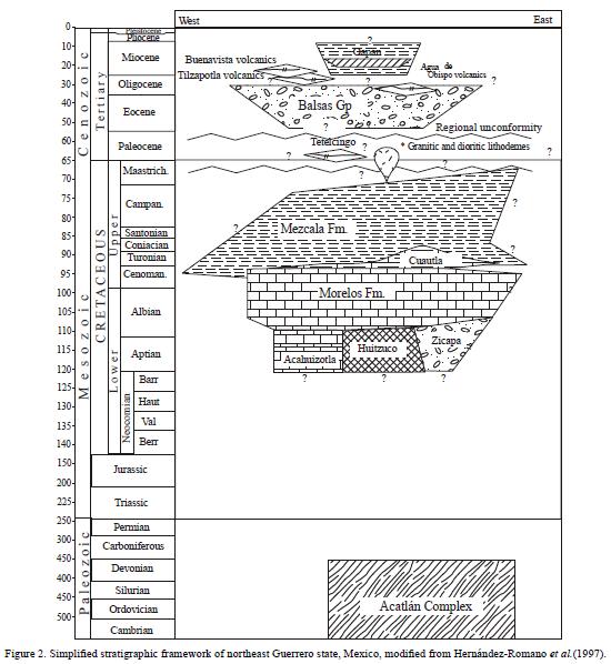
Cenozoic strata in northeastern Guerrero state have been assigned in ascending stratigraphic order to the Tetelcingo Formation, the Balsas Group, the Tilzapotla Rhyolite, and the Oapan Formation (Figure 2). The Balsas Group, the subject of this article, overlies volcanic bearing continental strata of the Maastrichtian–Paleocene Tetelcingo Formation (Ortega–Gutiérrez, 1980), or folded Cretaceous strata of the Morelos and Mezcala Formations along a widespread regional unconformity (Figure 2). Previous works indicate that Balsas strata are not affected by compressional deformation, although strata are locally folded, tilted and faulted (Cerca–Martínez et al., 2004). Balsas strata are locally overlain in angular unconformity by volcanic deposits of the Tilzapotia caldera, which are dated at ca. 34 Ma (Morán–Zenteno et al, 1999, 2003) or by coeval volcanic products from other sources. Where volcanic rocks are absent, lacustrine strata of the Oapan Formation of assumed Miocene age (de Cserna et al., 1980) unconformably overlie the Balsas Group. Edwards (1955) studied "the Taxco red conglomerate", that is now considered part of the Balsas Group. This conglomerate overlies the Acamixtla ignimbrite, dated at 38 Ma (Alaniz–Álvarez et al, 2002). The age of the Balsas Groups has thus been assumed to be Paleocene to upper Eocene.
Linares and Urrutia–Fucugauchi (1981) reported a K–Ar age of 49 ± 3 Ma for the Tilzapotia rhyolite, and assumed Balsas strata in the area north of Taxco (Figure 1) to be lower Eocene, but those ages are no longer considered reliable due to the more coherent group of dates (38 to 32 Ma) reported later (Alaniz–Álvarez et al., 2002). Additional radiometric data are available for the Balsas Group in the Copalillo basin (Cerca–Martínez, 2004). Plagioclase concentrate for an ignimbrite that overlies limestone boulder conglomerate near Tuzantlán (Figure 3) yields a 40Ar/39Ar date of 32.5 ± 0.3 Ma, but the spectra suggests excess Ar; a similar rock was dated by Campa–Uranga et al. (2002), who reported in an abstract an age of ca. 35 Ma. Because no sufficient data are provided by Campa–Uranga et al. (2002), these data should be viewed with caution. Near Atenango del Rio (Figure 1), Cerca–Martínez (2004) reports a date of 37.6 ± 0.3 Ma for andesites that appear to be intercalated with rocks considered by him correlative with the Balsas Group. Thus, available radiometric data restrict the Balsas Group to the Late Eocene and Early Oligocene.
The usual interpretation of the tectonic setting of the Balsas Group is as a post–orogenic molíase deposited in intermontane basins, after the Laramide orogeny. Basin margins or depocenters have not been, however, well described in the literature; nor facies or thickness variations have been published with sufficient detail. Jansma and Lang (1997) suggested that Balsas strata accumulated in depressions formed by "basin and range" style extension. These authors typify this style of deformation and deposition in the Arcelia graben, in north central Guerrero, northeast of Altamirano City (Figure 1). In this area, deposition of Paleogene clastic strata (assigned to the lowerBalsas Group) appears to be controlled by north to north–northwest trending normal faults of pre–Oligocene age (Jansma and Lang, 1997). Nonetheless, no widespread extension, grabens, or large–scale normal faults have been documented in other areas of Balsas deposition. Furthermore, Cerca–Martínez et al. (2004) have proposed that deformation linked to transpressive stress occurred during Balsas deposition in northeastern Guerrero, an area that includes the Tuzantlán–Copalillo basin. Centeno–García et al. (2004) have shown that the use of Balsas Group for continental strata in the Arcelia region, south of Morelia (Figure 1), is inadequate; deposits characterized by limestone conglomerate and coarse sandstone facies can be shown biostratigraphically to be of Cretaceous to Paleocene(?) age. Centeno–García et al. (2004) proposed instead the use of the name Cutzamala Formation for these upper Cretaceous and Paleocene strata. The Cutzamala Formation contains abundant volcanic clasts; it may thus be partially coeval with the Tetelcingo Formation of northern Guerrero.
FACIES DISTRIBUTION AND PREVIOUS STRATIGRAPHIC FRAMEWORK OF THE TUZANTLÁN–COPALILLO BASIN
Dávila–Alcocer (1974), Fitz–Diaz (2001), and Cerca–Martínez (2004) have identified and mapped basins where Cenozoic strata accumulated in the region between Paso Morelos and Copalillo, in northeastern Guerrero (Figure 1). The Copalillo basin (Cerca–Martínez et al, 2004), the most eastward of the basins, is bordered to the east by the Papalutla fault and by uplifted metamorphic rocks of the Acatlán complex (Figure 1). The Tuzantlánbasin is bordered to the west by a domal structure characterized by thick exposures of carbonate rocks of the Morelos Formation (Figure 1). Outcrops of Oligocene volcanic rocks poorly define the northern margins of the basins, and the basins are connected to the south with the upper Balsas–Mezcala river basin. It is evident that after deposition of the Cenozoic sequences, the basins were modified by normal, reverse, and strike–slip faulting. A facies reconstruction presented below suggests that during deposition of the Balsas Group the basins behave as a single basin, with sediment sources to the west and a depocenter near the town of Copalillo. We thus refer collectively to these basins as the Tuzantlán–Copalillo basin, whilst Fitz–Diaz (2001) referred to it as the Zacango synclinorium.
The fill of the Tuzantlán–Copalillo basin along the western margin is characterized by polymictic, limestone boulder, matrix–supported conglomerate, well exposed near Paso Morelos (Figure 1), which overlies folded strata of the Mezcala Formation. Conglomerates are massive or poorly bedded, and the matrix is coarse to medium sandstone of red color. An intraformational angular unconformity exposed south of Paso Morelos indicates active tectonism during deposition (Figure 3a). These conglomeratic facies grade laterally, towards the east, into clast–supported interbedded pebble and boulder conglomerate and conglomeratic sandstone (Figure 3b). Channel–filling conglomerate deposits are clearly identified within this section. A section of this facies is well exposed west of Tuzantlán where strata dip gently (<10°) to the east. Common sedimentary structures in this sequence include trough and planar cross stratification, clast imbrication, normal grading, and sand waves. Transport direction is to the east–northeast. Facies associations suggest deposition in alluvial fans and bajadas, grading eastward into braided stream deposits. Previous workers have assigned these deposits to the Balsas Group.
In the valley east of the town of Tuzantlán, the gravels of the Balsas Group are disconformably covered by flat–lying green mudstone, sandstone, tuff, and locally by a lithic–poor, pumice–bearing crystalline ignimbrite. We correlate these volcanic rocks with the ignimbrite dated by Cerca–Martínez (2004) and Fitz–Diaz (2001) inca. 35 Ma. The contact between the flat–lying green mudstones and the Balsas gravels is illustrated in Figure 3c. It is thus well established that a fine–grained greenish tuffaceous sequence overlies the Balsas Group. Elsewhere in the Mezcala–Balsas river basin, strata that overlie the Balsas Group have been assigned to the Oapan Formation (Nájera–Garza, 1965).
Previous workers (Dávila–Alcocer, 1974; Fitz–Diaz, 2001; Cerca–Martínez, 2004) mapped the fine–grained sequence that overlies the Balsas conglomerate beds between Paso Morelos and Atenango del Rio (Figure 3 c) as the Oapan Formation, although lithologic similarities between rocks originally defined as the Oapan Formation and the rocks exposed near Tuzantlán are weak. The original definition of the Oapan Formation at San Agustín Oapan (Figure 1) applies to predominantly lacustrine claystone, gypsum, limestone, and green tuffaceous sandstone (Nájera–Garza, 1965). More typical throughout the Tuzantlánbasin, there are exposures of greenish–gray sandstone interbedded with mudstone, also mapped as Oapan Formation (e.g., Fitz–Diaz, 2001).
Near the apparent basin depocenter, north of Atenango del Rio, a 150 m thick sequence consisting of several fining–upward, 10 to 20 meter–thick cycles composed of a basal red, coarse to medium, conglomeratic, lenticular, cross–bedded sandstone, fine sandstone sheets, and a thick package of red mudstone have been assigned to the informal Zacango beds (Fitz–Diaz, 2001). The Zacango beds overlie andesite flows and a thick–bedded, greenish red sandstone sequence. In turn, these beds underlie a rhyolitic ignimbrite that we correlate with the ignimbrite dated by Fitz–Diaz (2001) in ca. 35 Ma. The sequence is well exposed along the Amacuzac river valley dipping gently (27°) to the north (Figures 1 and 3f). The correlation of the Zacango beds in the Tuzantlán–Copalillo with either the Oapan Formation or the Balsas Group is partly the motivation of this article.
A section of strata mapped as the Oapan Formation in the Tuzantlán–Copalillo basin is illustrated in Figure 3d and 3e. We interpret sandstone beds in this sequence as shallow–channel fluvial deposits. Sandstone beds are 30 cm to about 1 meter thick, and they are greenish gray. The beds contain basal erosive surfaces with thin basal gravel–lag deposits, and display sedimentary structures such as trough cross bedding, horizontal lamination, and sand waves. Mudstone intervals are about 1–2 meters thick, they are locally horizontally laminated, and are interpreted by us as overbank deposits. The architecture of the deposits includes about the same proportion of channel and overbank deposits. Thus sedimentary structures and facies relations indicate that these are fluvial deposits with frequent avulsion and a relatively fine load. They are thus apparently different facies than those originally described for the Oapan Formation; nonetheless they are in similar stratigraphic position. Lag deposits in the channels include ignimbrite, rhyolite clasts, and abundant chalcedony. Sedimentary structures indicate east to southeast sediment transport.
For the Zacango beds, the sandstone bodies at the base of each cycle contain basal erosive surfaces and lag deposits. The siltstone–claystone deposits are characterized by paleosols which contain carbonate nodules, root marks and small (3 cm deep and 1 cm in diameter) cylindrical burrows, differentially cemented, interpreted as arthropod burrows. Facies associations of the Zacango beds suggest to us deposition in meandering stream systems. The fining–upward cycles are interpreted as fluvial deposits consisting of channels and sand point bars, splay deposits, and thick overbank deposits. The channels are probably deep, judging by the thickness of the sandstone beds (2 to 4 m; Figure 3f). Paleocurrent data indicate sediment sources to the west and east–northeast flowing streams. Plant remains are scarce, which in combination with the presence of carbonate nodules suggest deposition in arid continental climates. Conglomeratic sandstones in the Zacango beds do not contain volcanic clasts; here limestone clasts are dominant.
Lacustrine facies as those typical of the Oapan Formation at its type locality are not abundant in the sections that we studied, but Fitz–Diaz (2001) recognized a horizon of lacustrine limestone in the Zacango beds along the Amacuzac valley (Figure 1). In an abstract, Campa–Uranga et al. (2002) reported palynomorphs of Eocene age from these deposits north of the village of Zacango, but assigned the rocks containing these fossils to the Oapan Formation, despite the fact that they underlie an (undated) ignimbrite.
Thick siltstone and mudstone deposits, reddish gray, locally laminated but often lacking sedimentary structures are also present in the eastern part of the basin around Copalillo (Figure 3g). These strata may be interpreted as lacustrine, but we carried only reconnaissance work in this area. We refer to these strata as the Copalillo beds (informal). Cerca–Martínez (2004) mapped these rocks as the Tetelcingo Formation; we note however that volcanic material in the sequence is absent and contradicts the definition of the Tetelcingo Formation.
REVISED STRATIGRAPHIC FRAMEWORKAND FACIES RECONSTRUCTION
Correlation of conglomeratic strata between Tuzantlán and Paso Morelos with the Balsas Group based on lithologic similarities and stratigraphic position is straightforward. We assign the red sandstone and mudstones of the Zacango beds also to the Balsas Group. Petrographic description of the coarse sandstones of the Zacango beds show that they are lithic quartzarenites with a large component of limestone grains and no volcanic material, in marked contrast with the greenish gray lithic sandstones west of Tuzantlán assigned by other workers to the Oapan Formation.
The fluvial deposits east of Tuzantlán (Figure 3e) and at Zacango (Figure 3f) are two distinct sequences. The differences between the sequences include color, clast composition and sandstone petrology, bedding style, sedimentary structures, and overall architecture of the deposits. Furthermore, the sequence east of Tuzantlán is tuffaceous, the sequence at Zacango is not, and chalcedony is also not present in the Zacango sandstones.
The distribution of facies along the east–west transect along State Highway 1 (Figure 4), limited paleocurrent data, and evident lateral facies changes suggest that the conglomeratic Balsas facies grades eastward into sandstone–conglomerate Balsas facies; this facies grades eastward into sandstone–mudstone facies formerly included in the Zacango beds. Based on these observations, we propose that the Tuzantlán–Copalillo basin consists on its base of an eastward prograding wedge of alluvial fans and bajada deposits, that change laterally (eastward) and upward to east–northeastward flowing braided stream deposits, which in turn grade upward and eastward into meandering stream channel and overbank deposits. The sequence is approximately 200 m thick, but may be thicker along the western margin of the basin.
Depositional environments changed significantly in response to emplacement of the volcanic products of the Tilzapotla caldera and coeval volcanic fields in northern Guerrero. Volcanic rocks have been recognized within the Tuzantlán–Copalillo basin, and are well exposed along State Highway 1. Ash fall deposits can be recognized within a road cut near Tuzantlán, and a 3 m thick, welded, pumice–rich ignimbrite outcropping east of Atenango del Rio has been correlated with the eruption of the Tilzapotla caldera, about 60 km northwest of this locality. Fluvio–lacustrine deposits, mapped as the Oapan Formation by previous workers, overlie this ignimbrite deposit. It is thus apparent that distal caldera deposits decreased relief and blocked drainages; in turn basin deposits became lower–energy facies such as the Oapan lacustrine and fluvial beds. We note however, that mapping these rocks as the Oapan Formation requires a broader definition of this unit, a definition that recognizes fluvial facies as an important component. Redefinition of the Oapan Formation is beyond the scope of this article.
The correlation of the thick sequence of fine–grained (non–volcanic) siliciclastic rocks described as the Copalillo beds (Figure 3g) with the Balsas Group is uncertain. Available data does not allow to relate them conclusively to a particular depositional cycle (Tetelcingo, Balsas or Oapan). A pre–Cenozoic age can be ruled out by available radiometric data (Cerca–Martínez, 2004). Cerca–Martínez (2004) reports a pre–Eocene age for an andesitic dike that intrudes limestones below the base of the Copalillo sequence, and a Paleocene age for a biotite separate from a lithic tuff intercalated in a volcanic breccia that underlies the red mudstone sequence.
We note however, that a thick and coarse clastic wedge of limestone boulder conglomerate as that exposed in the western margin of the basin is absent in the east near the Papalutla fault. This suggests that the highlands presently east of the Copalillo basin, exposing Cretaceous limestone and basement rocks of the Acatlán Complex, were not a source of coarse elastics during deposition of the red siliciclastic mudstone sequence of the Copalillo beds. It also appears that an unamed sequence of greenish brown sandstone, conglomerate and mudstone, tilted eastward, overlies the mudstone sequence of Copalillo. Rhyolite clasts in the unnamed sandstone sequence suggest that it post–dates the main volcanic episode in this region (Late Eocene – Early Oligocene). This would place the underlying Copalillo mudstone sequence (Figure 3) in the same stratigraphic position as the Balsas Group. We thus tentatively assign the Copalillo beds to the Balsas Group.
To what extend the Tuzantlán–Copalillo basin can be prolonged to the south has not been established in the course of this work, but a similar southward variation in facies distribution can be recognized along the toll road to Acapulco (Highway 95–D) between Paso Morelos and the Balsas–Mezcala River. Conglomeratic facies grade southward into interbedded coarse sandstone and conglomerate. Further south, red to greenish red fluvial channel and over–bank deposits with interbedded gypsum beds are present. A section exposed along the highway north of the Mezcala river (Figure 3h), and overlying Cretaceous strata, is dominated by thick red sandstone facies and red mudstones with secondary gypsum. The highway section includes a 3 m thick pumice rich ignimbrite that we sampled for 40Ar/39Ar geochronology (Highway locality, Figure 1). The sequence that overlies the ignimbrite at this locality is lithologically similar to the sequence beneath it. It does not resemble the rocks assigned to the Oapan Formation at Tuzantlán by previous workers, nor the sequence assigned to the Oapan Formation near San Agustín Oapan. The Oapan Formation crops out further south of the Mezcala river along Highway 95–D where it consists of cyclic deposits of mudstones, lacustrine limestone and laminated gypsum.
PALEOMAGNETIC SAMPLING AND LABORATORY METHODS
We collected samples for 12 paleomagnetic sites from a section of the Zacango beds along the Amacuzac River, north of Atenango del Rio (18°11' N – 99°3.5' W) and 17 sites from a lithologically similar section at a road cut along the toll road México–Acapulco, at 17°58' N – 99°19' W, about 65 km southwest of the Amacuzac river section. Both sections are assigned to the Balsas Group. Samples were drilled in the field with a gas powered portable drill and oriented in situ with magnetic and sun compasses and an inclinometer. Sites (=one bed) consist of 5 to 7 oriented samples drilled preferentially in medium to fine–grained sandstone beds, and spaced through the section at irregular intervals averaging about 5 meter. Sampling locations are shown in Figure 1 and sampled sections are sketched in Figures 5a and 5b. As mentioned above, a 3 m thick, pumice–rich ignimbrite, with quartz, plagioclase, sanidine, and biotite crystals occurs within the toll road section and is overlain by an altered rhyolitic flow. Samples of the ignimbrite were collected for radiometric dating.
The paleomagnetic samples were prepared in the laboratory and pilot samples were subjected to stepwise alternating field (AF) and thermal demagnetization. Natural remanent magnetizations (NRMs) of pilot samples were measured in a cryogenic magnetometer at the paleomagnetic laboratory of the University of New Mexico, Albuquerque, using a cryogenic 2G Enterprises magnetometer. The rest of the samples were demagnetized and measured at the laboratory of the Centro de Geociencias, UNAM, in Querétaro, Mexico, using a spinner JR5 magnetometer.
The vectorial composition of the NRM was analyzed using orthogonal demagnetization diagrams and the directions of the magnetization components determined using standard principal component analysis software (Kirschvink, 1980). Mean directions were calculated assuming the distributions of directions are well described by a Fisherian distribution. Polarities were interpreted as normal (north directed and downwards) or reverse (south directed and upwards), whereas boundaries between normal and reverse polarity zones were placed halfway between sites of opposite polarity.
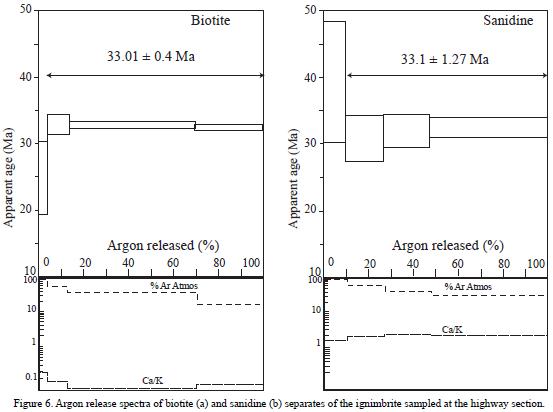
Geochronological data were obtained for biotite and sanidine separates, although later inspection revealed that the sanidine separate contained plagioclase. These minerals were concentrated and cleaned by standard techniques and later selected by careful handpicking under a binocular microscope to ensure the purity of the samples. Sample fractions ranged in size from 40–100 mesh, and were obtained at the mineral separation laboratory of the Centro de Geociencias (Querétaro, Mexico). Mineral separates were loaded into Al–foil packets and irradiated together with Mac–83 biotite as a neutron–flux monitor at the McMaster Nuclear Reactor (Hamilton, Ontario). 40Ar/39Ar analyses were performed by standard laser step–heating techniques, described in detail by Clark et al. (1998), at the Geochronology Research Laboratory of Queen's University, Kingston, Ontario, Canada. All data have been corrected for blanks, mass discrimination, and neutron–induced interferences. For the purposes of this paper, a plateau age is obtained when the apparent ages of at least three consecutive steps, comprising a minimum of 55% of the 39Ar released, agree within 2o error with the integrated age of the plateau segment.
RESULTS
Geochronology
The biotite and sanidine separates provide relatively noisy apparent age spectra and do not conform to strict plateau criteria. The biotite produced a climbing–spectrum for the first steps, suggesting Ar loss and an apparent pla– teau date of33.01±0.36Ma (Table 1, Figure 6) from the three highest temperature steps. An isochron provides a statistically similar date. The isochron date is 32.58 ± 0.64 Ma, with initial 40Ar/36Ar = 301.6 ± 16.33, MSWD = 1.05, (Figure 6) and the sanidine (and plagioclase?) separate produced a concordant date as expected at 33.10 ± 1.27 Ma. The isochron date is 33.83 ± 3.06 Ma, with initial 40Ar/36Ar = 291.43 ± 62.07, MSWD = 3.81. While only four steps were obtained for the sanidine, since the crystals became clear and therefore we could not heat them with the laser anymore to release more Ar, the Ar release spectrum does not provide good indications of either Ar loss or alteration. Even though contamination by plagioclase is apparent in the relatively high Ca/K ratios of about 2. The best estimate of the age of emplacement is 33 Ma.
Paleomagnetic results
The characteristic magnetization (ChRM) of samples of the Amacuzac section is nearly univectorial. The ChRM is of high maximum but distributed unblocking temperatures (200–650 °C; Figure 7a and 7b). AF demagnetization to 115 mT does not remove a significant fraction of the remanence. The ChRM is directed to the northwest and is of, in situ, moderate to steep inclination. Beds dip at shallow angles (25°) to the northwest, and a tilt correction shallows the inclinations. The magnetizations are of uniform normal polarity (Figure 8).
Rocks of the highway section are typically made of two magnetization components, a soft, low unblocking temperature (< 300 °C) magnetization, north directed and of shallow inclination, and a dual polarity characteristic magnetization with unblocking temperatures between 300 and 550 °C, and moderately high coercivities (Figures 7c–7e). In the majority of these samples, the ChRM is of reverse polarity, south directed and of negative inclination. Not in all the samples can the magnetization be estimated by fitting a line to the origin because no stable end point direction is reached due to unstable behavior at high temperatures, or because of persistent overlap in the coercivity or unblocking temperature spectra of the north directed overprint and the reverse polarity magnetization. Nonetheless, polarity interpretations are unambiguous at all sampling levels. Site mean directions were estimated using great circle trajectories (poles to great circles are plotted in Figure 8)
Isothermal remanence acquisition curves for samples collected do not saturate with maximum inductions of 3 T, but a large fraction of the IRM is acquired with inductions of 0.1 T, indicating the presence of a significant fraction of a cubic phase such as magnetite or maghemite. Demagnetization behavior and rock magnetic data indicate that the characteristic remanence resides primarily in hematite, whilst the north directed overprint likely resides in coarse–grained magnetite or maghemite grains.
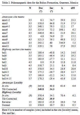
The ChRM is interpreted as a chemical remanent magnetization acquired soon after deposition. Magnetizations clearly predate tilt, as in the case of the Amacuzac section the in situ direction does not resemble the late Tertiary or a younger field direction but the tilt corrected direction does (Table 2). An angular unconformity within conglomeratic strata near Paso Morelos suggests that faulting is locally contemporaneous with deposition. This, in turn, suggests that rocks were tilted soon after deposition; the magnetization is thus interpreted as a primary, or near primary remanence. Site means and overall means are listed in Table 2. For the Highway section, samples for six adjacent sites were combined in three, in order to provide a combined mean of stable end–points and great circle site means. For the Amacuzac section two sites were excluded from the overall mean as they do not provide sufficient samples with a well–defined ChRM.
Magnetostratigraphy
The magnetic polarity zonation of the columns studied is compared with the global polarity time scale (GPTS, Cande and Kent, 1995) in Figure 9. A composite section is built assuming that the highway section overlies the river section. This assumption is based on the reported presence of an ignimbrite at Zacango up–section from the locality where we collected at the Amacuzac river valley. Because of the relatively uniform bedding direction of Zacango beds at the Amacuzac river locality, where we sampled, and the Zacango locality of Fitz–Diaz (2001), the studied section must be older than the ignimbrite exposed about 2 km to the north. In turn, the Amacuzac river section must be older than the highway section. We grant, however, that this assumption is weak. There is no apparent reason to believe that the Amacuzac and the highway sections overlap in time; in fact, the base of the highway section is of opposite polarity than the top of the Amacuzac section. We nonetheless assume that the gap between both sections is of relatively short duration. Again, this assumption is weak and cannot be tested directly.
The polarity zones are labeled A through C, from bottom to top (Figure 9). Two data can be used to correlate the Balsas section to the GPTS. These are the date reported by Cerca–Martínez (2004) for andesites below the base of the Amacuzac section, and the unnamed ignimbrite of site bal6 at the highway section. The radiometric data indicates that the Amacuzac section cannot be older chron C17n; in turn, radiometric data for the Highway section is consistent with our assignment of the reverse polarity magnetozone B– to chron C12r.
The composite magnetic polarity sequence of the Balsas Group does not provide a unique correlation to the GPTS. A long normal polarity zone at the Amacuzac section is overlain by a long zone of predominantly reverse polarity with two normal events at the highway section. The sampling interval is relatively open, thus short polarity events may have escaped detection. We present three possible correlations between the magnetic polarity zonation in the composite sections and the GPTS; these are labeled 1 to 3 in Figure 9. Within the resolution provided by geochronological data, the polarity zonation may correlate with chrons clónto cl3r, as indicated by dotted lines in Figure 9 (correlation 1). This correlation suggests a short interval of deposition of approximately 3 millionyears, and would suggest that the sequence records the complete chron sequence. At the other extreme is correlation 2 (dashed lines in Figure 9). The correlation suggests that several gaps exist and that the sequence corresponds to chrons C17n to C11r. Yet, considering the ages of the dated volcanic units, the prevalence of normal polarities at the base and reverse polarities on the top is consistent with the proposed correlation that makes the section span chrons C17n to C12r (correlation 3 in Figure 9). This correlation, would indicate a long interval of deposition of the Zacango beds in the Copalillo–Tuzantlán basin of approximately 5 million years, and would suggest that some short chrons eluded sampling. We lack sufficient elements to argue in favor of either correlation, but we favor the later. Thus, deposition of the Balsas Group in the Tuzantlán–Copalillo basin occurred during the Late Eocene and Early Oligocene, between about 37 and 32 Ma.
Regional correlations
Near the village of Amacuzac, about 70 km northwest of the study area, Monter–Ramírez et al. (2004) reported a thickness of 2.5 km for the Balsas Group. This sequence is significantly thicker than the section studied at the Amacuzac river valley, where it is about 200 m. The section near Amacuzac studied by Monter–Ramírez et al. (2004) includes a lower sequence and an upper sequence. The lower sequence is conglomeratic at its base and thins upward, becoming dominated by sandstones and mudstones. The upper sequence is again dominated by coarse elastics, overlain in angular unconformity by ignimbrites that yield K–Ar dates between 34 and 35 Ma. The sequence includes andesite and rhyolite flows, and ignimbrite deposits similar to the volcanic rocks of the Taxco and Tilzapotla volcanic fields. The Balsas Group is interpreted here as alluvial fan deposits forming the fill of intermontane basins. The coarse deposits at the base of the lower sequence of the Amacuzac section may correlate with the conglomeratic Balsas facies near Paso Morelos. But it is evident that the coarse elastics that post–date the volcanic episode belong to different environments than the Oapan Formation in the Tuzantlán–Copalillo basin. We note, however, that those deposits are proximal with respect to the Tilzapotla caldera.
DISCUSSION OF TECTONIC IMPLICATIONS OF THE PALEOMAGNETIC DATA
Mean directions obtained for rocks of the Balsas Group can be compared with the expected directions calculated from the reference apparent polar wander path of North America. Discordant directions, if present, may thus be used to validate tectonic models proposed for the region or to propose new models. The section of the Balsas Group sampled at the Amacuzac river valley gives an overall well defined mean directed to the north and of moderate inclination (dec=340.8°, inc=34.3°; k=62.6, n=9, α95=6.6°). The Balsas Group at the highway section, gives an overall mean of (dec=351.0°, inc=39.9°; k=70.4, n=9, α95=6.2°), which is equally well defined. These data supersede a previous estimate of the mean paleomagnetic direction for the Balsas Group (Urrutia–Fucugauchi, 1980) for which not sufficient laboratory and sampling details are available. The directions observed at both localities are statistically distinct with a level of significance of 5%, due mostly to a difference in declination. These data suggests that there is a small relative tectonic rotation between both localities.
When compared with the expected field direction of D=354.7° and 1=32.8°, the Balsas mean at the highway section is concordant. In contrast, the Amacuzac section indicates a small counterclockwise rotation (13.2° ± 8°), evident by declinations to the northwest and insignificant inclination anomaly (1.5° ± 9°). The rotation occurred in the Oligocene or at a later time.
Similar counterclockwise rotations, but of larger magnitude, have been reported in southern Mexico for Cretaceous (Molina–Garza et al, 2003) and Tertiary rocks (Urrutia–Fucugauchi, 1983; Molina–Garza et al, 2004). Counterclockwise rotations have been also reported for plutons along the Pacific coast (Bohnel etal, 1989). Infact, in nearly all localities studied in southern Mexico west of the Papalutla thrust, paleomagnetically determined rotations are counterclockwise. These data are summarized in Molina–Garza et al. (2003). Rotations have generally been interpreted as local rotations, that is, rotations of crustal blocks of relatively regional extension (tens of kilometers) that rotate about a vertical axis. Paleomagnetically determined rotations are of the order of 20° for Cretaceous strata, but reach values as high as 55° (Molina–Garza et al., 2004). An important observation is that the Balsas Group does not record rotations as high as those observed in older rocks. This observation partly constraints the timing of rotation. On one hand, it demonstrates that they are not restricted to the Laramide kinematics. On the other, it demonstrates that the driving mechanism (s) was waning by Early–Oligocene time.
The close uniformity in rotation (counterclockwise) sense is suggestive of a common forcing mechanism. The principal mechanisms that produce rotations of crustal blocks with respect to vertical axis have been amply discussed in the literature (Butler, 1992, and references therein). In general, rotations are linked to en–echelon geometries that involve strike–slip faults, distributed shear in a region bounded by strike–slip faults, fault drag, and to transpression or transtension. Some observations in the Guerrero–Morelos platform suggest that crustal block rotation has occurred at variable scales, such as the deflection of Laramide structures apparent in Figure 1, north and south of Chilpancingo (Cerca–Martínez et al., 2004), which is also supported by paleomagnetic data for Mesozoic strata (Molina–Garza et al, 2004).
Left lateral strike–slip motion has been proposed for several northwest to west–northwest trending structures in southern Mexico (e.g., Meschede et al., 1997; Martiny et al., 2000; Alaniz–Álvarez et al, 2002; Nieto–Samaniego et al, 2005), thus the geometries required to explain counterclockwise rotation can be tested against available paleomagnetic data. A possible mechanism linked to transpression is illustrated in Figure 10; here, sampling sites in southern Mexico are framed within a broad left lateral shear system (Figure 10a), and Laramide structures that trend north–south are required to accommodate a small right lateral component in order to explain counterclockwise rotation (Figure 10b). Right–lateral faults have been reported by Nieto–Samaniego et al. (2005) in the northeast portion of the Guerrero–Morelos platform, and we observed similar structures, yet small, affecting the Amacuzac section. Alternatively, a greater amount of shortening must be accommodated by the thrust faults in the southern part of the rotated domain (Figure 10c). Greater amount of shortening in the southern part of the platform is rather evident (Cerca–Martínez, personal communication 2005).
The magnetostratigraphy provides the means to estimate the rate of deposition. The preferred correlation between the magnetic polarity zonation in the Balsas Group indicates a rate of deposition of about 20 m/My, the alternative interpretation indicates a slightly higher rate of about 30 m/My. Both rates are relatively low for a tectonically active basin, or one that subsides rapidly.
CONCLUSIONS
The Balsas Group in the Tuzantlán–Copalillo basin consists of alluvial fan, bajada, and fluvial deposits. Sedimentation was contemporaneous with deformation. The sequence was probably deposited in Late–Eocene to Early–Oligocene time, in the lapse between the chron sequence C17n to C12r. Continental clastic deposition in northern Guerrero was influenced by the emplacement of volcanic rocks of the Tilzapotla caldera and correlative volcanic fields. Units mapped as the Oapan Formation in the Tuzantlán–Copalillo basin post–date the main volcanic episode, but their age is most likely Oligocene. Paleomagnetic directions for the localities studied constrain the timing of counterclockwise rotation in southern Mexico, in the Guerrero–Morelos platform and its surrounding region.
ACKNOWLEDGEMENTS
This research was supported by a grant to R. S. Molina–Garza by the PAPIT–UNAM program. The 40Ar/39Ar analytical work was supported by a Natural Sciences and Engineering Research Council of Canada Major Facilities Access grant and a Discovery grant to JKW Lee, and an individual CONACyT–33–100T research grant to M. A. Ortega–Rivera. We thank Arturo Martín Barajas, Dante Morán Zenteno and Susana Alaniz Álvarez for comments than improved to the original version of this manuscript.
REFERENCES
Alaniz–Álvarez, S.A., Nieto–Samaniego, A.F., Morán–Zenteno, D.J., Alba–Aldave, L., 2002, Rhyolitic volcanism in extensión zone associated with strike–slip tectonics in the Taxco region, southern México: Journal of Volcanology and Geothermal Research, 118, 1–14. [ Links ]
Böhnel, H, Alva–Valdivia, L., González–Huesca, S., Urrutia–Fucugauchi, J., Morán–Zenteno, D., Schaaf, P., 1989, Paleomagnetic data and the accretion of the Guerrero terrane, southern México continental margin, in Hillhouse, J.W. (ed.), Deep Structure and Past Kinematic of Accreted Terranes: American Geophysical Union, Geophysical Monograph Series/International Union of Geodesy and Geophysics (IUGG), 5, 73–92. [ Links ]
Butler, R.F., 1992, Paleomagnetism; Magnetic domains to geologic terranes: Cambridge, Massachusetts,Blackwell Scientific Publications, 319 p. [ Links ]
Campa–Uranga, M.F., Fitz–Díaz, E., Martínez, E., 2002, Revisión de la edad de la Formación Oapan y su significado en el graben de San Agustín Oapan y el Sinclinorio de Zacango, Estado de Guerrero (abstract), in III Reunión Anual de Ciencias de la Tierra, Puerto Vallarta, Jal., México, Libro de Resúmenes: Unión Geofísica Mexicana, GEOS, 22, p. 165. [ Links ]
Cande, S.C., and Kent, D. V., 1995, A revised calibration of the geomagnetic polarity timescale forthe Late Cretaceous and Cenozoic: Journal of Geophysical Research, 100, 6093–6095. [ Links ]
Centeno–García, E., Benammi, M., Altamira–Areyán, A., Martínez–Hernández, E., Morales–Games, M., Callejas–Moreno, J., 2004, Evolución tectono–sedimentaria de la cuenca continental cretácica de Tierra Caliente, Michoacán. Resultados preliminares (abstract), in IV Reunión Anual de Ciencias de la Tierra, Juriquilla, Querétaro, México, Libro de Resúmenes, p. 217. [ Links ]
Cerca–Martínez, M., 2004, Deformación y magmatismo Cretácico Tardío – Terciario temprano en la zona de la Plataforma Guerrero Morelos: México, D.F.,Universidad Nacional Autónoma de México, Posgrado en Ciencias de la Tierra, Ph.D Thesis, 175 p. [ Links ]
Cerca–Martínez, M., Ferrari, L., Bonini, M., Corti, G., Manetti, P, 2004, The role of crustal heterogeneity in controlling vertical coupling during the Laramide shortening and the development of the Caribbean–North American transform in southern Mexico; insights from analogue models, in Grocott, J., Taylor, G., Tikoff, B. (eds.), Vertical Coupling and Decoupling in the Lithosphere: Geological Society London, Special Publication, 227, 117–140. [ Links ]
Clark, A.H., Archibald, D.A., Lee, A.W., Farrar, E., Hodgson, C.J., 1998, Laser probe 40Ar/39Ar ages of early– and late–stage alteration assemblages, Rosario porphyry copper–molybdenum deposit, Collahuasi District, I Region, Chile: Economic Geology, 93, 326–337. [ Links ]
Dávila–Alcocer, V.M., 1974, Geología del área de Atenango del Río, Estado de Guerrero, México: México, D.F., Universidad Nacional Autónoma de México, Facultad de Ingeniería, Tesis Profesional, 79 p. [ Links ]
De Cserna, Z., Ortega–Gutiérez, F., Palacios–Nieto, M., 1980, Reconocimiento geológico de la parte central de la cuenca del Alto Río Balsas, Estados de Guerrero y Puebla, in V Convención Geológica Nacional, Libro–guía de la Excursión Geológica a la Parte Central de la Cuenca del Alto Río Balsas, estados de Guerrero y Puebla: México, D.F., Sociedad Geológica Mexicana, 1–33. [ Links ]
Edwards, J.D., 1955. Studies of some early Tertiary red conglomerates of central Mexico: United States Geological Survey, Professional Paper, 264–H, 183 p. [ Links ]
Fitz–Díaz, E., 2001, Evolución estructural del sinclinorio de Zacango en el límite oriental de la Plataforma Guerrero Morelos: México, D.F., Instituto Politécnico Nacional, Escuela Superior de Ingeniería y Arquitectura, Tesis Profesional, 103 p. [ Links ]
Fries, C, 1956, Bosquejo geológico de la región entre México D.F. y Taxco, Gro., in XX Congreso Geológico Internacional, Libreto Guía de las excursiones A4 y C2: México, D.F., Universidad Nacional Autónoma de México, 11–36. [ Links ]
Fries, C, 1960, Geología del Estado de Morelos y de partes adyacentes de México y Guerrero, región central–meridional de México: México, D.F., Universidad Nacional Autónoma de México, Boletín del Instituto de Geología, 60, 236 p. [ Links ]
Hernández–Romano, U., Aguilera–Franco, N., Martínez–Medrano, M., Barcel–Duarte, J., 1997, Guerrero–Morelos Platform drowning at the Cenomanian–Turonian boundary, Huitziltepec area, Guerrero State, southern Mexico: Cretaceous Research, 18, 661–686. [ Links ]
Jansma, P.E., Lang, H.R., 1997, The Arcelia Graben; new evidence for Oligocene Basin and Range extension in southern Mexico: Geology, 25, 455–458. [ Links ]
Kirschvink, J.L., 1980, The least–squares line and plane and the analysis of paleomagnetic data; examples from Siberia and Morroco: Geophysical Journal of the Royal Astronomical Society, 62, 699–718. [ Links ]
Linares, E., Urrutia–Fucugauchi, J., 1981, On the age of the Riolita Tilzapotla volcanic activity and its stratigraphic implications: Isochron West, 32, 5–6. [ Links ]
López–Ramos, J., 1979, Geología de México, Tomo 2: México, DF., Tesis Rezendis, 454 p. [ Links ]
Martiny, B., Martínez–Serrano, R., Morán–Zenteno, D.J., Macías–Romo, C, Ayuso, R., 2000, Stratigraphy, geochemistry and tectonic significance of the Oligocene magmatic rocks in western Oaxaca, southern Mexico: Tectonophysics, 318, 71–98. [ Links ]
Meschede, M., Frisch, W., Herrmann, U., and Ratsbacher, L., 1997, Stress transmission across am active plate boundary; an example from southern Mexico: Tectonophysics, 266, 81–100. [ Links ]
Molina–Garza, R.S., Bohnel, H., Hernández–Treviño, T., 2003, Paleomagnetism of the Cretaceous Morelos and Mezcala Formations, southern Mexico: Tectonophysics, 361, 301–317. [ Links ]
Molina–Garza, R.S., Ferrari, L., Cerca–Martínez, M., 2004 A paleomagnetic test of the role of crustal heterogeneity in controlling strain transfer in a wide left lateral shear–margin, southern Mexico (abstract): Geological Society of America, Abstracts with Programs, 36(5), p. 435. [ Links ]
Monter–Ramírez, A., Morán–Zenteno, D.J., Alba–Aldave, L., Centeno–García, E., 2004, Revisión de la estratigrafía del Grupo Balsas en el área de Amacuzac, Estados de Morelos y Guerrero (abstract), in IV Reunión Anual de Ciencias de la Tierra, Juriquilla, Querétaro, México, Libro de Resúmenes, p. 126. [ Links ]
Morán–Zenteno, D.J., Toisón, G., Martínez–Serrano, R.G., Martiny, B., Schaaf, R., Silva–Romo, G., Alva–Aldave, L., Hernández–Bernal, M.S., Solís–Pichardo, G.N., 1999, Tertiary arc magmatism of the Sierra Madre del Sur, Mexico, and its transition to the volcanic activity of the Trans–Mexican Volcanic Belt: Journal of South American Earth Sciences, 12, 513–535. [ Links ]
Morán–Zenteno, D.J., Martiny, B., Alva–Aldave, L., González–Torres, E., Hernández–Treviño, T, Alaniz–Álvarez, S., 2003, Tertiary magmatism and tectonic deformation along the Cuernavaca–Acapulco transect, in Geologic transects across cordilleran Mexico, Guidebook for the fieldtrips of 99th Geological Society of America Cordilleran Section Annual Meeting, Puerto Vallarta, Jalisco, Mexico, April 4–6: México, D.F., Universidad Nacional Autónoma de México, Instituto de Geología, Fieldtrip 11, 261–280. [ Links ]
Nájera–Garza, J., 1965, Estudio geológico del área de San Agustín Oapan, Estado de Guerrero, México: México, D.F., Instituto Politécnico Nacional, Escuela Superior de Ingeniería y Arquitectura, Tesis Profesional, 47 p. [ Links ]
Nieto–Samaniego, A.F., Alaniz–Alvarez, S.A., Silva–Romo, G., Eguiza–Castro, M.H., Mendoza–Rosales, C.C., 2005, Latest Cretaceous to Miocene deformation events in the eastern Sierra Madre del Sur, México, inferred from the geometry and age of major structures: Geological Society of America Bulletin, 118, 238–252. [ Links ]
Ortega–Gutiérrez, F., 1980, Rocas volcánicas del Maestrichtiano en el área de San Juan Tetelcingo, Estado de Guerrero, in Sociedad Geológica Mexicana, Libro guía de la excursión geológica a la parte central de la cuenca del alto Río Balsas, in V Convención Geológica Nacional, Libro–guía de la Excursión Geológica a la Parte Central de la Cuenca del Alto Río Balsas, estados de Guerrero y Puebla: México, D.F., Sociedad Geológica Mexicana, 34–38. [ Links ]
Urrutia–Fucugauchi, J., 1980, Paleomagnetic studies of Mexican rocks: United Kingdom, University of New Castle upon Tyne, Ph.D. Thesis, 689 p. [ Links ]
Urrutia–Fucugauchi, J., 1983, Preliminary paleomagnetic study of Lower Tertiary volcanic rocks from Morelos and Guerrero states: Geofísica Internacional, 22, 87–110. [ Links ]
Zijderveld, J.D.A., 1967, A.C. demagnetization of rocks; analysis of results, in Collinson, D.W., Creer, K.M., Runcorn, S.K. (eds.), Methods in Rock Magnetism and Paleomagnetism: Amsterdam, Elsevier, 254–286. [ Links ]

