


Servicios Personalizados
Revista
Articulo
 texto en
  Inglés (pdf)
 Artículo en XML
 Referencias del artículo
 Enviar artículo por email
Indicadores
-
 Citado por SciELO
 -
 Accesos
Links relacionados
-
 Similares en
SciELO
Similares en
SciELO
Compartir

 Permalink
Problemas del desarrollo
versión impresa ISSN 0301-7036
Prob. Des vol.47 no.184 Ciudad de México ene./mar. 2016
https://doi.org/10.1016/j.rpd.2016.01.002
Articles
The City System and Urban Networks in Mexican Economic Models
aInstituto de Investigaciones Económicas de la UNAM, México
This paper analyzes how the structure and functioning of the system of cities in Mexico has changed in the framework of the economic models implemented in the country, drawing on the results of spatial interaction models. This article reviews three studies based on data obtained in 1966, 1986, and 2006 through classic gravity models, which permit a comparative analysis that reveals the transition from a hierarchical cities model in the closed-economy model to the emergence of regional-urban systems organized into networks in the midst of trade liberalization. Finally, it reflects on some causal explanations.
Keywords: System of cities; regional urban development; spatial interaction; networks of cities; economic models
En el presente artículo se analizan los cambios en la estructura y el funcionamiento del sistema de ciudades de México, en el marco de los modelos económicos aplicados en el país y con resultados de modelos de interacción espacial. Se revisan tres estudios elaborados con datos obtenidos en 1966, 1986 y 2006 mediante modelos gravitacionales clásicos que permiten un análisis comparativo que revela la transición de un modelo jerárquico de ciudades en el modelo de economía cerrada, a la emergencia de sistemas urbano-regionales organizados en redes en el marco de la apertura comercial y se reflexiona sobre algunas explicaciones causales.
Palabras clave sistema de ciudades; desarrollo urbano regional; interacción espacial; redes de ciudades; modelos económicos.
Dans le présent article sont analysés les changements survenus dans la structure et le fonctionnement des villes du Mexique, dans le cadre des modèles économiques appliqués dans le pays et avec des résultats de modèles d'interaction spatiale. Il est procédé à la révision de trois études menées sur des données obtenues en 1966, 1986 et 2006 à travers des modèles gravitationnels classiques permettant une analyse comparative qui révèle la transition d'un modèle hiérarchisé de villes à l'économie fermée vers l'émergence de systèmes interurbains régionaux organisés en réseaux dans le cadre de l'ouverture commerciale, et il est mené une réflexion sur quelques explications causales.
Mots clés système de villes; développement interurbain régional; interaction spatiale; réseaux de villes; modèles économiques.
No presente artigo se analisam as mudanças na estrutura e funcionamento do sistema de cidades do México, no marco dos modelos econômicos aplicados no país e com resultados de modelos de interação espacial. Revisam-se três estudos com dados obtidos em 1966, 1986 e 2006 através de modelos gravitacionais clássicos que permitem uma análise comparativa que revela a transição de um modelo hierárquico de cidades no modelo de economia fechada, a emergência de sistemas urbano-regionais organizados em redes no marco da abertura comercial e se faz uma serie de considerações sobre algumas explicações causais.
Palavras-chave sistema de cidades; desenvolvimento urbano regional; interação espacial; redes de cidades; modelos econômicos.
本文在墨西哥实施的经济模式框架内,采用空间相互作用模式的结果,分析墨西哥城市系统的运行及其结构变化。本文对三项研究进行了回顾分 析,这三项研究通过经典引力模型于1966年、1986年和2006年获得了相 关数据,利用这些数据进行的对比分析揭示了城市系统由封闭经济模式下 的阶级模式向贸易开放框架下网络式 区域城市系统的过度。此外,本文就 过度原因进行了思考。
关键词 城市系统; 区域城市发展; 空间相互作用; 城市网络; 经济模式
INTRODUCTION
The urban-regional development process in Mexico has historically been unequal and has promoted concentration in big cities, which can be explained in large part by the economic models adopted in the country. Under the Import Substitution Model (ISM), the most dynamic regions were generally those that accumulated capital, concentrated infrastructure and urban services, and specialized in a few industrial manufacturing or extractive activities (mining and oil) produced for the domestic market. On the other hand, under the Trade Liberalization Model (TLM), in place for three decades now, export regions with a strong manufacturing industry experienced the fastest growth, especially in the central and northern regions of Mexico, thanks to trade with the United States, as well as in some metropolitan regions specialized in services (financial, commerce, and tourism) tied to global capital circuits. These discrepancies are reflected in the spatial distribution patterns of the population and economic activities in Mexico, which have shifted from a high degree of agglomeration-in a few cities with a hierarchical structure in a closed model-to a more open model with weaker convergence and city networks that have emerged in some of the most dynamic regions.
In this context, this paper will address three studies that draw on classic spatial interaction models, and which also share some aspects of the methodology in order to compare the results over time. The data express changes between periods of approximately 20 years, pursuant to the economic policies Mexico has adopted, looking at hierarchies and the major links between the largest cities, their zones of influence, and their economic and demographic significance.
ECONOMIC MODELS IN MEXICO
Throughout the twentieth century, Mexico implemented various economic models, each of which has prompted its own urban development patterns and dynamics in terms of territorial inequality. Mexico is generally said to have advanced through three models: a) the Primary Export Model in the post-revolution era (1900-1939), marked by slow urbanization and rural predominance; b) the Import Substitution Model (1940-1984), notable for rapid and widespread urbanization that produced conditional convergence; and c) the Trade Liberalization Model (1985-2014), with moderate and diversified urbanization, which in the first half of the period displayed regional divergence and, in the second half, weak conditional convergence. The latter half consisted of three phases: a) macroeconomic structural adjustment, trade liberalization, and deregulation (1983-1994), as Mexico signed the first General Agreement on Tariffs and Trade (GATT) and then the North American Free Trade Agreement (NAFTA), pursuant to the directives of the Washington Consensus, 1 marked by major banking crises and external shocks, as well as average Gross Domestic Product (GDP) growth of 2.6%; b) the intensification of structural change (1995-2000) with lower inflation and an increase in imports and exports; and c) economic stagnation (2001-2015), with moderate urbanization, but expanded and diversified metropolization, the rise of city networks, weak regional conditional convergence, legislative paralysis for two six-year terms, and a major international financial crisis (see Table 1).
Table1 Economic and Urban Models in Mexico

Source: Created by the autor base don ONUH-Hábitat, Sedesol, 2011; Villareal, 2012; Mendoza, 2012; and Solis, 2014.
In the framework of Mexico's economic models, the urbanization process has gradually shifted from a highly hierarchical system of cities in a closed economy to a more disperse and diversified structure of urban-rural networks in the midst of trade liberalization. This evolution has been characterized by cycles of convergence and divergence. In the current neoliberal phase, inequality is prevalent and gaps between the regions have widened, although these developments have taken place concurrent to the rise of new metropolitan hubs and the emergence of urban networks, no less exempt from severe socioeconomic and environmental problems.
STUDIES ABOUT THE CITY SYSTEM IN MEXICO
Mexico's cities have been studied at various points in time to characterize their structure, functioning, dynamics, and interactions. Multiple studies have applied spatial interaction models to determine the hierarchy and inner workings of these human settlements, drawing on data regarding the exchange of goods, services, or information, as well as mobility. These models are idealized and synthesized representations of movements or communications about the space in which decisions are made. Flows are caused by centrifugal and centripetal forces, as well as various other factors, such as the supply and demand for goods and services in the territory, availability and quality of infrastructure, transportation times and costs, connectivity, and more. These models apply descriptive-deterministic assumptions and display the gravitation proposed by W.J. Reilly (1931), inspired by Isaac Newton's Universal Law of Gravitation, which states the following: "the force with which two bodies attract each other is directly proportional to the product of their masses and inversely proportional to the square of the distance between them."
Some studies of city systems in Mexico conducted pursuant to this logic combine, in an eclectic fashion, these theories and variants proposed by Walter Isard (1971), take into account the General Systems Theory (Bertalanffy, 1986), and maintain a formal tie to the Central Place Theory (Christaller, 1933; Lösch, 1954), with ideas related to Innovation Diffusion (Hägerstrand, 1966), or spatial population distribution laws, such as the Rank-Size rule (Zipf, 1949), among others. 2
These papers estimate the interactions between pairs of cities and characterize the system, which is defined as a set of integrated, interrelated, and interdependent human settlements, with a network of flows that comprise a unit whole, and which organize the territory into a complex structure consisting of central places that play a certain role in achieving a common objective, each of which has its own zones of influence (Berry, 1964; Bertalanffy, 1986). 3
In general, gravity models provide consistent descriptive results about the workings of urban systems, which can be analyzed using alternative theoretical approaches. In fact, when the historical conditions of social formation are modified, new analytical paradigms are needed, such as dynamic networks. 4
Interaction models take into account the functional relationships with indicators for flows of all types (capital, labor, information, trade, transportation, services, etc.), which shape the links between the urban centers operating in the value chains. These connections are the raison d'être of cities and therefore cannot be examined in isolation; this is even more true in the context of globalization, which requires operational support (Friedman, 1995; Taylor, 2004; Sassen, 2010; Parnreiter, 2014). 5
The three studies described here apply gravity models pursuant to the information available at the time they were conducted and with a time interval of approximately 20 years between each study (see Table 2).
Table 2 Studies of the city System in Mexico

Source: Created by the author based on Unikel, Garza, and Ruiz, 1978; Conapo, 1991; and Sedesol, IIEc, UNAM, 2012
Below are the principal results of the research studies described, followed by an integrated analysis.
The City System and the Urban Hierarchy, 1971
In pioneering studies in Mexico published in the book El Desarrollo Urbano de México (Urban Development in Mexico)coordinated by Luis Unikel, gravity models were used to determine the position and potential of 38 cities (which had 50,000 residents or more in 1960) in the force field of the "economic space" of the national urban system, by estimating with multiple regressions of five matrices the vehicle, passenger, and tons of industrial cargo traffic flowing between pairs of urban centers, while also drawing on information collected between 1963 and 1968, when Mexico was still operating under the import substitution model. In addition, four values with gravity masses were obtained for: population, hotel beds, industrial production, and amount of sales in trade, which is why the principal components method was used to determine a single value for the potential of a city. In turn, this method was used to characterize central places (in the sense of Christaller), with an urbanism index, and a standard of living index was also calculated for social, educational, and housing variables (Unikel and Necochea, 1971).
The results revealed that: a) with a high correlation (r=0.84), when the size of the city's population increased, so too did the number of specialized economic, financial, and cultural activities of regional and national importance; b) larger cities had higher standard of living, with a weaker association (r=0.57); c) there was strong demographic, social, and economic centralism, with Mexico City in the top group and significantly so (20 times higher than Guadalajara and 12 times higher than Monterrey, and responsible for over half of national trips), two cities in the second group, eight in the third, and 27 in the fourth, which represented a distribution characteristic of an underdeveloped country; d) cities in the central region were dependent on the capital of the country; e) there were subsystems of cities in the Bajío (north/central) region, towards the Pacific coast, and around Veracruz, but with weak integration; f) cities such as Mérida, Durango, and Villahermosa were notably isolated; and g) in terms of potential, Mexico City stood out for its large population and economic weight, Monterrey for its industry, and the port of Acapulco for its significance in the national and international tourism industry (Unikel, Garza, and Ruiz, 1978).
The City System and the Spatial Distribution of the Population, 1991
In 1991, the National Population Council (Conapo) published another study, which characterized the system of cities in Mexico, drawing on the Central Place theory, the Innovation Diffusion theory, and Systems theory. The result was a document entitled Sistema de ciudades y distribución espacial de la población en México (The City System and the Spatial Distribution of the Population in Mexico) (Conapo, 1991), together with the guidelines of the National Population Program 1989-1994, aiming to make Mexico's population distribution more balanced, taking on concentration and sprawl with policy proposals to promote small and medium-sized cities pursuant to their growth potential and some other aggregate territorial variables related to the economic, social, and natural resources realms.
This study also applied a gravity model with data on population size by city, telephone calls between pairs of urban hubs, and the shortest highway distance between them. 6 The results established a functional hierarchical ranking of the cities and defined 31 subsystems of cities as areas of influence for the central places on a different order, as well as eight functional regions with state borders.
The classification of the 79 central places was as follows: Rank 1 included the Metropolitan Region of Mexico City (MRMC), which played a prominent role and accounted for 6.6 times the population of the next highest city in the ranking; Rank 2, which included three metropolitan regions: Monterrey, Guadalajara, and Puebla, all of which exercised significant influence in their larger regions; Rank 3, which included eight cities primarily located in the central and northern regions of Mexico and which played a role as articulators or integrators between lower-level cities and towns; Rank 4, with 12 cities, linked to other larger or smaller cities within their state, and if tied to cities in another state, the amount of interaction declined as distance grew; Rank 5, whose 18 cities were distributed throughout various regions of Mexico and, although able to offer goods and services, constituted small regions within their own states; and finally, Rank 6, where the 37 towns did not have enough power of concentration and the supply of goods and services were rather like small cities specialized in a single economic activity, generally traditional, and spread throughout the country with average potential to retain or absorb the population.
The National Territorial Strategy, 2012
The Social Development Ministry and the Institute for Economic Research at the National Autonomous University of Mexico partnered to produce the document Estrategia Territorial Nacional (National Territorial Strategy) which revealed, among other results, the outcome of a gravity model that took into account the following variables: a) as gravity masses, the gross added value estimated for 2005 and the population per city using data from the Second Population and Housing Census from the same year; b) the distance between pairs of city by highway and the shortest route going point to point as per the Ministry of Communications and Transportation (SCT, 2010); and c) overland traffic with income generated for cargo and passenger transport services between city pairs, calculated based on 2006 data reported in the Annual Transportation Survey 2007 (INEGI, 2007). In this study, Mexico's city systems were analyzed based on the Principal Urban System (PUS) cities (including cities with over 50,000 residents), because they constitute the nucleus of the socioeconomic and demographic dynamics in the country. In 2005, the system had a population of over 67 million inhabitants, accounting for 65.5% of the national total, and consisted of 128 cities sorted into six groups by functional ranking.
Rank 1 contained the Metropolitan Area of the Valley of Mexico (MAVM); Rank 2 included the metropolitan areas of Monterrey and Guadalajara; Rank 3 encompassed another seven cities; in Rank 4 were nine urban centers; in Rank 5, another 37; and in Rank 6, the remaining 72. A description of the hierarchy of the cities by rank and the principal information about them is found in Table 3.
Table 3 Mexico, Population, EAP, and Gross Added Value by Functional Hierachy of Cities, 2005.

Source: Created by the author based on Sedesol, IIEc, UNAM, 2012
Rank 1. This group maintains the national importance of the MAVM as a demographic, socioeconomic, political, and administrative hub, which in 2005 was home to 18.6% of the national population and generated 30.3% of the national gross added value. This metropolitan area is the center of the system of cities with direct or indirect influence, to a greater or lesser extent, on the entire country. It is the principal destination of traffic coming from the majority of urban centers.
Rank 2. This group includes the metropolitan areas of Monterrey and Guadalajara as important services centers with macro-regional influence, which account for high portions of the population, and also complement some of the functions carried out by the MAVM. In terms of their importance for the workings of the system, the metropolitan area of Monterrey receives first-order traffic from 20 cities, second-order from 37 cities, and third-order from 15, making it the primary node in the northeast area of the country. As such, it has benefitted as one of the winners in the trade liberalization game, and is located in the most dynamic corridors of NAFTA. The metropolitan area of Guadalajara is the hub linking the western part of Mexico's territory, and although it does not receive first-order traffic, it does receive traffic from 15 and 24 cities on the second and third order, respectively. The gap between the MAVM and Monterrey was twice as wide, while it was three times as wide for Guadalajara.
Rank 3. The cities in this group have a rather smaller area of influence, which generally does not go beyond the state borders of each place. Of the seven cities in this hierarchy, five of them are located within the direct influence zones of cities that exert greater gravitational force. This is the case of the metropolitan areas of Puebla and Toluca, which are tied to the MAVM, and the metropolitan areas of Saltillo and Reynosa, which are part of the metropolitan area of Monterrey. In turn, Chihuahua and Ciudad Juárez complement each other and constitute a subsystem in the border state.
Rank 4. This group of cities contains two main types of behavior. The first consists of a subgroup linked to other but less powerful hubs, such as the metropolitan areas of León, San Luis Potosí, Querétaro, Veracruz, and Mérida; the second consists of cities that are subordinated to others ranked higher in the hierarchy, such as the metropolitan areas of Tijuana, La Laguna, Nuevo Laredo, and Matamoros.
Rank 5. The cities in this group account for 14.9% of the national population and 15.8% of the gross national added value, and are located throughout the Mexican territory in a more balanced fashion. In some regions, principally in the southern part of the country, they serve as the central hub, especially in state city systems, like in the metropolitan areas of Morelia, Acapulco, Oaxaca, and Tuxtla Gutierrez, and in the north of the cities of Hermosillo and Los Mochis.
Rank 6. The influence zone of this group of central places is rather smaller and their role is limited to linking nearby places within the same state, even though they are spread throughout the entire national territory (see Map 1).
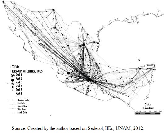
Although the gravitational weight 7 of these cities in Mexico has shifted throughout the period, the overall structure in which the MAVM is the apex of the workings of the national urban system has persisted, even as a nascent network of urban hubs with complementarities, interactions, and rising economic power has also emerged, especially in El Bajío and in the northeastern part of the national territory. This confirms the existence of an eclectic model of cities through the coexistence of traditional economic activities alongside more modern activities tied to the impacts of globalization in some regions.
The Shifting Gravitational Forces of Cities
The three aforementioned studies allow for a comparison of the major cities in Mexico at different time periods through the lens of similar approaches and measurement methods. Although the data are not entirely comparable, the changes observed in the urban structure reveal a clear trend towards a relative decline in the hierarchy of the cities located in the central swath of the country, the growing importance of various urban hubs throughout the north, and modest growth for those located in the south.
The gravitational weight of cities located in the central section of the country fell from 78.4% in 1966 to 67.8% in 1986, and to 48.3% by 2006, entailing a total decrease of 30.1% over these 50 years. This reduction is principally due to the fact that the MAVM became relatively less important as compared to the other 38 cities considered in the study in 1966, 8 such that its hierarchical weight dropped from 63.5% to 27.9%, and then to 25.6% in the same three years (if all cities are taken into account, the relative share of the MAVM falls even more). The cities located in the north of Mexico saw functional importance rise from 19.8% to 46.9%, that is, a gain of 27.2% over the four decades covered by these studies. In the southern portion of the country, the major cities grew modestly from 1.8% to 4.7%, in other words, a 2.9% increase in the same time period (see Table 4).
Table 4 Mexico: Changes in the Gravitational weight of Principal Cities, 1966-2006. a_/

a_/The only cities considered are the 38 analyzed in the 1966 study Source: Prepared
Some metropolitan areas, like those surrounding Guadalajara, Puebla-Tlaxcala, León, Veracruz, and Xalapa saw their functional importance rise between 1966 and 1986, but then fall again over the next 20 years, while other zones, like Toluca and Querétaro, saw an overall increase in relevance. In the north, some cities experienced an increase in gravitational force during the trade liberalization period in the framework of NAFTA. This was the case of the metropolitan areas of Monterrey, Reynosa-Río Bravo, Saltillo, Tampico, Matamoros, and Nuevo Laredo, all of them located in the most dynamic economic corridor between Mexico and the United States; to a lesser extent, the same was true of Chihuahua, Ciudad Juárez, La Laguna, and Ciudad Victoria; likewise, the cities along the Pacific coast saw relatively modest growth.
From the Hierarchical System to the Emerging Network of Cities
The hierarchized system under the ISM gave rise to another emerging system in some regions where city networks began to take shape. By the time Mexico had transitioned to the TLM, in 2006, there 128 cities with over 50,000 inhabitants, that is, 90 more than the 38 originally considered in 1966, a clear sign of a more diversified and decentralized urban system, with cities that grew rapidly under trade liberalization.
The city system displayed a basic organizational structure, with three major metropolitan regions generating 53.0% and receiving 39.1% of the national total of overland cargo and passenger traffic. These areas include the MAVM (37.5% and 20.4% of traffic, respectively), Monterrey (10.1% and 10.4%), and Guadalajara (5.4% and 8.3%). The metropolitan areas of Cuernavaca, Tlaxcala, Toluca, Pachuca, Puebla, and Querétaro gravitate around the MAVM; Tampico, Saltillo, and Reynosa around Monterrey; and León and Morelia, principally around Guadalajara. The top ten metropolitan areas alone accounted for 38.4% of all highway traffic in the PUS (see Table 5).
Table 5 Mexico. Overland Cargo and Passenger Traffic of the 10 Principal Metropolitan Areas, 2006. Percentage. a/

a./ Includes intra-metropolitan flows. Source: Estimates made by the author.
The changes in the infrastructure and functioning of Mexican cities over the past three decades can be explained in large part by the implementation of the liberalization model. The country signed the GATT in 1986 and this measure was accompanied by the structural reform of economic liberalization, reduced intervention by the State in the economy, the privatization of state enterprises, and, after NAFTA took effect in 1994, the elimination of tariffs and the promotion of exports. The outcome of this model for Mexico was to intensify the exchange of goods and services with, more than any other country, the United States. Mexican exports to its northern neighbor increased four-fold between 1993 and 2013; foreign direct investment (FDI) rose ten-fold in the same period (half coming from the United States), and in per capita terms, was higher than that entering the BRICS. Moreover, the macroeconomic variables in Mexico-such as interest rate, exchange rate, and inflation-tend to converge with those of the United States and Canada; likewise, the economic cycles of the three countries are in tune with one another, especially for industrial production between Mexico and the United States (Serra, 2015).
The economic impact of NAFTA has been tremendous. However, trade liberalization and economic integration had a lesser effect on economic growth and job creation, and also generated some negative consequences, including the exacerbation of social, labor, and regional inequalities, both in terms of the structural gap and in disparate growth rates.
In the territorial realm, it is vital to highlight the emergence of a few hubs and city networks. These can be observed in the systems that generated the greatest amount of highway traffic for both origin and destination, and which had the greatest number of cities of different orders: MAVM-Toluca-Cuernavaca (32.6% of total traffic with 10 cities), Monterrey-Saltillo-Reynosa (17.9% with 10 cities), Veracruz-Xalapa-Coatzacoalcos (7.3% with 13 cities), Guadalajara-Manzanillo-Puerto Vallarta (6.7% with 11 cities), Chihuahua-Ciudad Juárez (5.5% with 6 cities), and Querétaro-León (4.7% with 15 cities).
These metropolises have their own gravitational force and their own respective areas of influence, shaping the 20 functional regional urban systems, which can be separated into three broad swaths of the Mexican territory pursuant to the Regional Development Programs for North, Center, and South-Southeast, 2014-2018, prepared by the Ministry of Agrarian, Territorial, and Urban Development (see Table 6).
Table 6 Regional Urban Systemes by the Geographic Area and Overland Traffic from Origin and Destination, 2006.

1/Data estimated with a gravity model; 2/the regional divisions provided in the Regional Development Programs from 2013 are considered. Source: Created by the author based o Sedesol, IIEc, UNAM, 2012.
The central region displays systems influenced primarily by the MAVM and the metropolitan area of Guadalajara, comprising a growing regional urban network that explains why major multinational and national companies choose to invest and set up offices in the region. These systems demonstrate more horizontal and complementary interactions among urban centers, which permit the emergence of economies of agglomeration, specialization, and cooperation with innovation and human capital.
Bajío is home to a network of cities that has seen the rise of a major agroindustrial, automotive, manufacturing, electronics, aerospace, mining, footwear, and biotechnology corridor, among other sectors (as well as the traditional agriculture and livestock, food industry, and tourism), having seized on its advantageous location, skilled human resources, better quality of life, infrastructure, and a wide range of government support to attract both national and international corporations. This region has experienced the multiplicative effects of increased competitive cooperation among businesses with linkages and exchanges with cities of various sizes that act as hubs of economic activity. The national and foreign investment rate has remained high, stimulating the creation of local enterprises. For example, in the auto parts sector, many small and medium-sized enterprises, with the potential to grow and export their goods, and which pay better relative wages and favor the articulation of regional production chains by requiring leather components, such as seats and steering wheels, have been opened. In this sense, the role of local governments in promoting and generating favorable conditions to attract investment and develop the regional potential has been fundamental, as have been scholarship programs and employee training, support with subsidies and infrastructure, and the formation of venture capital funds drawing on public and private resources to start up or expand companies, among other measures.
As compared to more dynamic regions, the south has fairly low articulation and limited integration among its city systems, which is a factor in the low development found in the territory, which also has low production levels and the highest rates of poverty and marginalization in the country, despite enjoying significant natural resources, especially in the states of Guerrero, Oaxaca, and Chiapas.
DISCUSSION ABOUT TERRITORIAL CHANGES
Under the trade liberalization model, in general, the location of production tended to be closest to the relevant market for Mexican products, in other words, the United States. For that reason, the border states to the north have grown faster than the national average and more than the states in the south of Mexico. The border states in the north enjoy the advantages of proximity to destination markets, the ease of integrating with the cross-border productive chains, experience in the maquiladora industry that dates back to the 1970s, the maturity of the local labor market, the provision of productive infrastructure, and the existence of an environment and policies conducive to the creation or attraction of companies under the cluster model. It also displays other important factors, like information and communication technologies, that facilitate connectivity with global networks. In turn, the northern border carries out the highest value added economic activities, which require better-skilled laborers and technology, while labor-intensive and low-wage jobs predominate in the south.
In this regard, some research has examined the spatial differences in countries with closed and open economies through the application of inter-regional trade models, with growing yields at scale, which assume urban agglomeration and that costs increase as a function of distance. In conditions where there are trade protections, two types of industrial hubs develop. The first, the primary type, produces for the domestic market in a concentrated fashion, while the other consists of small cities specialized in exportation, with low costs, located in regions nearby the international market. With trade liberalization, the economy grows and the productive profile of both types of urban centers shifts, such that production and employment fall in the former and rise in the latter, in the cities tied to the global markets (Hanson, 1994; Krugman and Livas, 1996; Rodríguez-Pose and Sánchez-Reaza, 2005).
Before Mexico joined NAFTA, the relative wages for manufacturing in Mexican states for were negatively correlated with the distance to Mexico City and the northern border of the country, while once trade liberalization began, this effect declined with respect to the capital and intensified with respect to the distance from the northern borders. Under the ISM, many companies were located in the MAVM, despite being home to higher wages, in response to the high demand for their products, the availability of suppliers, and skilled labor. Once liberalization began and companies started to produce for the global markets, as well as purchase inputs from abroad, alongside rising land prices in the central area of the country, this prompted a dispersion effect. As such, the new stable equilibrium came about through divergence, as the predominance of the MAVM fell and economic activities in other regions with easy access to foreign markets rose, especially along the border with the United States and at maritime ports. With NAFTA, the product per worker grew more in the cities along the northern border, as a result of: bigger economies of agglomeration (positive externalities), education, dissemination of knowledge, the existence of public assets, increasing population density, and lower transportation costs, because these cities were located close to their destination markets. Likewise, foreign direct investment accentuated the centrifugal forces that favored the decentralization of the territory, pushing up demand for specialized labor, but broadening regional and wage inequality in Mexico (Hanson, 1997; Brakman et al., 2009; Garduño, 2014).
These approaches explain the transition from a primary hierarchical model to a different model of a city network in Mexico, and can be confirmed with studies, such as those that apply a random effects panel model and incorporate the heterogeneity of the regions. From 1970 to 1985, the value was -2.70, which entails convergence under the protected trade model; from 1985 to 2001, during liberalization, the value was estimated to be 1.01, which expresses divergence; and, finally, between 2001 and 2010, the value was -0.49, a sign of a new phase of conditional regional convergence, but weaker this time, and with low economic growth, as Mexican states tied to the external sector lost competitiveness as a result of lower growth in the North American economy and competition from Asian products, as well as the momentum gained by mid-level economies in terms of income per capita. In turn, the gap between the rich and poor states in the country remained constant. "Between 1970 and 2010, the states converged around their own GDP per inhabitant in equilibrium (stationary state), with movements among the wealthier regions, but apparent stability among the poorer group" (Mendoza, 2012: 41).
A sigma convergence analysis indicates that the inequality in the product per capita between Mexican cities has maintained an upward trend, falling only at two key moments (1998 and 2008), which both coincide with crises. This means that inequality fell because the most dynamic cities slowed down, and not because the lagging cities caught up; in other words, this is a downward equalization. Among the principal factors that explain the divergent behavior of GDP per capita among regions and cities are differences in labor productivity associated with technology and spatial location, which during trade liberalization, favored the states and cities in the north and central-northern region of the country, thanks to their interactions with the United States (Quintana, 2013).
Liberalization drove the export model, but also prompted the dismantling of the domestic production chain and an assembly manufacturing model with a pro-import bias. The income-elasticity of imports rose from 1.26 to 4.58, between the ISM and the TLM, thereby reducing the multiplicative effects of exports for the national industry. The increase in the international flows of goods, inputs, and raw materials stimulated the economic growth of cities located with better access to global markets, excluding the poorer regions (Villareal, 2012).
This confirms that this proximity (cost/time) encouraged the growth of the urban centers that were most integrated with the North American economy, especially those located in the corridor running from the MAVM to San Antonio, Dallas, and Houston in Texas, United States, and which extends throughout the entire east coast of that country. By dividing the territory from north to south, it emerges that the East Coast contains 31 states that generated 69.3% of the total real GDP between 2010 and 2013, while the West contains 20 states that accounted for 30.7% (BEA, 2015). This confirms the prevailing forces of attraction in that country with the higher demand and economic sectors linked with those in Mexico, especially in states located near the Gulf of Mexico, where development has taken off in the framework of NAFTA. However, there are also cross-border relationships between the United States West Coast and the Mid-West and Mexican cities such as Tijuana, Ciudad Juárez, and Chihuahua.
In general, the new balance of centripetal and centrifugal forces has led to a new functionality for Mexican cities, but has also produced various problems derived from the growth and socioeconomic restructuring processes. Morphologically, city-regions, metropolitan areas, sub-centers, nodes, and borders emerge and mature to form cities that are increasingly poly-centric, but to varying degrees. Phenomena such as fragmentation, polarization, segmentation, segregation, diffusion, precarization, and peri-urbanization are just some of the features of this transformation, which entail social underdevelopment and risks for governability.
FINAL REFLECTIONS
The system of cities in Mexico has undergone unequal and concentrated development in the framework of the economic models adopted in the country. The ISM favored a hierarchical city model with urban hubs that accumulated capital, concentrated infrastructure and services, or specialized in a few manufacturing, extractive, or tourism activities. During the TLM, more opportunities became available for the emergence of city networks that have taken advantage of exports, which grew with the maquiladora industry, manufacturing, and services that are plugged into global circuits, although with lower economic growth and weak integration in regional productive chains. Some cities and states, especially in the central and northern regions of the territory, have advanced in forming clusters, with economies of agglomeration and positive externalities.
However, various challenges lie ahead. Macro-policies must consider how to promote growth-with special mind paid to industry-, draw on financing from development banks, and focus on small and medium-sized enterprises, support for innovation, science, and technology, and investment in infrastructure and furnishings, as well as the recovery of real wages to strengthen the domestic market.
In the territorial realm, socioeconomic inequality has intensified within the structure and dynamics of the national urban system. It will be important to prevent the development gap among the north, center, and south from widening. Regional development could be promoted through various measures, including the expansion of connectivity with corridors that attract investment, integrate productive change, and encourage the movement of people, goods, and services within the Mexican regions, while promoting improved socio-spatial equilibrium. Three connections to strengthen stand out: the northern border that connects the cities of Tijuana, Mexicali, Nogales, Ciudad Juárez, Piedras Negras, Nuevo Laredo, Reynosa, and Matamoros; the connection between Mazatlán and Matamoros, from Sinaloa to Tamaulipas; and the Isthmus of Tehuantepec, which would support better integration in the south.
Finally, the national urban system has undergone a transformation from a primary hierarchical model displaying strong concentration to the formation of city networks, with greater spatial decentralization. The challenge will be to foster territorial convergence by exploiting the positive aspects of liberalization, but with adequate urban-regional planning to enable Mexico to achieve the central objective of development, which is to improve the welfare of its people, regardless of where they live in the country.
REFERENCES
Brian Berry. Cities as Systems within Systems of Cities. Papers of Regional Science Association. 1964; 13, 1:146p [ Links ]
Ludwig Bertalanffy. Teoría general de los sistemas. México: Fondo de Cultura Económica; 1986. 311p [ Links ]
Steven Brakman, Garretsen Harry, Marrejwik Charles van. The New Introduction to Geographical Economics. England: Cambridge University Press; 2009. 551p [ Links ]
Bureau of Economic Analysis (2015), Real GDP by State, 2010-2013, disponible en https://www.bea.gov/newsreleases/regional/gdp_state/gsp_newsrelease.htm. [ Links ]
Roberto Camagni. Economía urbana. Barcelona: Antoni Bosch; 2005. 302p [ Links ]
Consejo Nacional de Población (Conapo) (1991), Sistema de ciudades y distribución espacial de la población, tomo I, México, pp. 146. [ Links ]
Walter Christaller. Central Places in Southern Germany. NJ, Prentice Hall: Englewood Cliffs; 1933. [ Links ]
John Friedman. Wher we Stand: A Decade of World City Research. World Cities in a World System. England: Cambridge University Press; 1995. 21p [ Links ]
Rafael Garduño. La apertura comercial y su efecto en la distribución regional de México. El Trimestre Económico. 2014; LXXXI (2),:413p [ Links ]
Torsten Hägerstrand. Aspects of the Spatial Structure of Social Comunication and the Diffusion of Information. Papers and Proceedings of the Regional Science Association, XVI. 1966; 16:27p [ Links ]
Gordon Hanson. Localization Economies, Vertical Organization, and Trade. Working Papers Series, núm 4744. Cambridge: National Bureau of Economic Research; 1994. 39p [ Links ]
Gordon Hanson. Increasing Returns, Trade and Regional Structure of Wages. The Economic Journal. 1997; 107:113p [ Links ]
Instituto Brasileiro de Geografía e Estatística (2008), Regioes de influencia das ciudades, 2007, Río de Janeiro. [ Links ]
Walter Isard. Métodos de análisis regional. Una introducción a la Ciencia Regional. Barcelona: Editorial Ariel; 1971. 815p [ Links ]
Paul Krugman, Raúl Livas. Trade Policy and the Third World Metropolis. Journal of Development Economics. 1996; 9:137p [ Links ]
August Lösch. The Economics of Location. New Haven and London, Massachusetts: Yale University Press; 1954. 517p [ Links ]
Miguel Ángel Mendoza. La dinámica económica regional de largo plazo en México: 1940-2010. Análisis espacial y regional. México unam,: Plaza y Valdés Editores; 2012. 21p [ Links ]
ONU Hábitat, Sedsol [ Links ]
Christof Parnreiter. ¿Network or Hierarchical Relations?. A Plea for Redirecting Attention to the Control Functions of Global Cities. Tijdschriftvoor Economischeen Sociale Geografie. 2014; 105:398p [ Links ]
Quintana, Luis (2013), “Las ciudades mexicanas y algunos de sus problemas básicos”, en Boletín Ciudades y Regiones, núm. 5, Jul-agosto, disponible en http://www.saree.com.mx/unam/node/61. [ Links ]
William J. Reilly. Law of Retail Gravitation. New York: William J. Reilly Co; 1931. [ Links ]
Andrés Rodríguez-Pose, Javier Sánchez-Reaza. Economic Polarization through Trade: Trade Liberalization and Regional Growth in Mexico. Spatial Inequality and Development. Oxford: Oxford University Press; 2005. [ Links ]
Saskia Sassen. Global Inter-city Networks and Commodity Chais: Any Intersections?. Global Networks. 2010; 150p [ Links ]
Secretaría de Comunicaciones y Transportes (2010), Rutas punto a punto, México, disponible en http://aplicaciones4.sct.gob.mx/sibuac_internet/ControllerUI?action=cmdEscogeRuta. [ Links ]
Secretaría de Comunicaciones y Transportes (2012), Comparativo de modos de transporte, México, disponible en https://www.google.com.mx/#q=sct+modos+de+transporte+2012. [ Links ]
Jaime Serra. El tlc y la formación de una region. México: Fondo de Cultura Económica; 2015. [ Links ]
Leopoldo Solís. La economía mexicana, en Reporte macroeconómico de México. México Universidad Autónoma Metropolitana. 2014, Ene; 5:9p [ Links ]
Peter J. Taylor. World City Network: a Global Urban Analysis. London: Routledge; 2004. 256p [ Links ]
Luis Unikel, Andrés Necochea. Jerarquía y sistema de ciudades de México. en Revista Demografía y Economía, México. 1971; 1:27p [ Links ]
Luis Unikel, Gustavo Garza, Crescencio Ruíz. El desarrollo urbano de México. México: El Colegio de México; 1978. 476p [ Links ]
René Villareal. El modelo económico del cambio. México: cecic; 2012. 197p [ Links ]
John Williamson. Latin American Adjustment: How much has happened?. Institute for International Economics, Conference Volume. 1990. [ Links ]
John Williamson. Democracy and the ‘Washington Consensus’. World Development. 1993; 21:1329p [ Links ]
George K. Zipf. Human Behavior and the Principle of Least Effort. Oxford, England: Addison-Wesley Press; 1949. 573p [ Links ]
1The Washington Consensus consisted of: i) budgetary discipline with no inflation tax; ii) the redirection of public spending towards highly economically profitable sectors with potential to improve income distribution (health and basic education and infrastructure); iii) tax reform to improve incentives and horizontal equality with a broader tax base of taxpayers and moderate taxes, as well as the taxation of capital flight as a medium-term priority; iv) financial deregulation and interest rates determined by the market; v) a unified and competitive exchange rate governed by the market to induce rapid growth in non-traditional sectors and exports; vi) trade liberalization with progressive tariffs; vii) opening up to foreign direct investment and permitting the entry of international companies to compete under equal conditions with national companies; viii) the privatization of state enterprises; ix) the deregulation of markets that were impeding the entry of new companies or competition and guarantees of security standards, environmental protection, or oversight of financial institutions; and x) security for ownership rights without excessive costs and available to the informal sector (Williamson, 1990 and 1993).
2Studies of hierarchy and areas of influence have been conducted using this method in various countries. One particularly noteworthy study of this kind in Latin America is published by the Brazilian Institute for Geography and Statistics, since 1966, most recently: Regiões de influência das cidades, 2007 (IBGE, 2008).
3"The gravity model and its derivations offer a synthesized expression and empirical measurement of the principle of spatial interaction, based on an analogy to gravitational physics...which is...an intrinsically weak point of this model"...(however)..."it is possible, through an analytical consideration of its logical elements, to come up with some comparative statics or quasi-dynamic reflections about the variations that may be produced in the hierarchy itself as the result of the temporal dynamics of economic and demographic variables" (Camagni, 2005: 84 and 117).
4 The "city networks" approach is defined as "[...] sets of horizontal and non-hierarchical relationships between complementary or similar hubs, relationships that realize the formation of economies or externalities related to, respectively, the specialization/division of labor and synergies/cooperation/innovation" (Camagni, 2005: 126). Although "[...] the network model is not a model of 'total' organization of the territory," it adapts well to some advanced sectors of industry and higher tertiary sectors in more developed countries or regions, and it juxtaposes with the hierarchical model that responds to the traditional sectors of lagging countries, so the overall model that emerges is of the eclectic type.
5The classic method used to characterize city systems is the gravity model, which assumes that the force of attraction of a city is the product of the masses divided by the square of the distance between them, such that the formula is: Where: Iij = Observed flows between cities i and j. (Pi Pj) = Product of the masses of cities i and j. (Dij) = Distance between cities i and j. K = Constant of proportionality derived from the propensity of people to interact. α and β = Parameters that weight the effect of the product of the masses by the measure of interaction and distance between them.
6The use of highway distances in the interaction models in Mexico is justifiable considering that, between 1995 and 2012, 98% of passengers traveled with this mode of transportation, and 56% of cargo was self-transported overland, as compared to 33% by maritime transport and 11% by rail (SCT, 2012).
7The gravitational weight is defined as the average of interactions between origin and destination, calculated with gravity models by city for all interactions in the matrix; the ranking from highest to lowest is used to divide the urban hierarchy into ranks.
Received: June 22, 2015; Accepted: October 05, 2015
 This is an open-access article distributed under the terms of the Creative Commons Attribution License
