


Servicios Personalizados
Revista
Articulo
 Inglés (pdf)
 Artículo en XML
 Referencias del artículo
 Enviar artículo por email
Indicadores
-
 Citado por SciELO
 -
 Accesos
Links relacionados
-
 Similares en
SciELO
Similares en
SciELO
Compartir

 Permalink
Hidrobiológica
versión impresa ISSN 0188-8897
Hidrobiológica vol.21 no.3 Ciudad de México sep./dic. 2011
Analysis of the effect of El Niño and La Niña on Tecocomulco Lake, central basin, Mexico
Análisis del efecto de El Niño y La Niña en el Lago de Tecocomulco, cuenca central de México
Guadalupe de la Lanza-Espino,1 Gabriela Gómez-Rodríguez,2 Arturo Islas Islas,3 Vicente Escalante Richards3 and Salvador Hernández Pulido1
1 Instituto de Biología, Tercer Circuito Exterior, Universidad Nacional Autónoma de México (UNAM). C.P. México D.F., 04510. México. e-mail: gdlle@unam.mx
2 Instituto de Geografía, Circuito Exterior de la Coordinación de la Investigación Científica, UNAM. C.P. 04510, México D.F.
3 Consejo Estatal de Ecología del Gobierno del Estado de Hidalgo. José Ma. Iglesias No. 100 Col. Centro, C. P. Pachuca, Hgo., 42000. México.
Recibido: 29 de octubre de 2010.
Aceptado: 02 de agosto de 2011.
ABSTRACT
Tecocomulco Lake is a relic of the great basin of the central plateau of Mexico. Its surface area changes in response to both the variation in the inputs from inland areas and the effects of the climatic phenomena of El Niño and La Niña. It is endorreic, with a low rainfall and a low and intermittent fluvial input, a high evaporation, and a considerable influx of sediment due to deforestation and a bad management of the basin. The most important plant species is Schoenoplectus californicusthat grows massively in muddy areas, decreasing the depth and reducing the flooded area. The lake is visited by birds from USA and Canada, that arrive to nest and reproduce. During the extremely dry years that coincide with the El Niño, approximately 9% of the dry surface is used by the local inhabitants as cropland, which generates a social problem during the extremely rainy years that coincide with the La Niña when the lake area increases and floods the cultivated land. In the 2001-2002 El Niño, the surface of Tecocomulco Lake decreased by 37% and the depth was 0.75-1 m. This may be associated with a higher temperature, and in consequence a high evaporation, a situation that requires corroboration through future studies.
Key words: Mexican lake, El Niño and La Niña.
RESUMEN
El lago de Tecocomulco es un relicto de la gran cuenca central de México. Su superficie varía en respuesta tanto de la variación en los aportes terrestres como de los efectos de los fenómenos climáticos El Niño y La Niña. Es endorreico, con una baja precipitación y un aporte fluvial bajo e intermitente, una alta evaporación, y una contribución considerable de sedimentos debido a la deforestación y a un mal manejo de la cuenca. La vegetación más importante es Schoenoplectus californicus que crece masivamente en áreas lodosas, disminuyendo la profundidad y reduciendo el área inundada. El lago es visitado por aves procedentes de EUA y Canadá, que llegan para anidar y reproducirse. Durante los años extremadamente secos coincidentes con el fenómeno de El Niño, las áreas desecadas son usadas por los habitantes locales en un 9% de su superficie aproximadamente para cultivos, generando un problema social durante los años extremadamente lluviosos coincidentes con La Niña, cuando el área del lago aumenta e inunda las tierras cultivadas. En El Niño 2001-2002, la superficie del Lago de Tecocomulco se redujo un 37%, generando una baja profundidad de 0.75-1 m que puede ser asociada con una mayor temperatura, y en consecuencia una alta evaporación, situación que debe ser corroborada con más estudios.
Palabras clave: Lago mexicano, El Niño y La Niña.
INTRODUCTION
The basin of Mexico lies in the southern section of the Mexican High Plateau (central part of the Trans-Mexican Volcanic Belt), between 19°01'18" and 20°09'12" N, and between 98°31'58" and 99°30'52" W. Its surface covers 9,560 km2 over four Mexican states. The basin, approximately 2240 meters above sea level, is the highest in the state of Hidalgo, and is surrounded by mountains higher than 5000 m. The average annual temperature is 15 °C. Most of the 700 mm of rain that fall every year in the region are concentrated in a few intense storms that regularly occur from June to September. Rainfall is scarce or absent the rest of the year.
The 11 lakes that constitute the basin of the Valley of Mexico have been extensively studied. The most important of these are Chalco, Xochimilco, Xaltocan and Zumpango. Tecocomulco Lake in Hidalgo has only recently been the object of research. It is considered to be one of the last natural wetlands of the old lake ecosystem that predominated in the basin of Mexico. The surface area of Tecocomulco Lake has undergone great changes, not only from year to year during the Holocene period, but also in inter-annual shorter periods. The lake's surface area tends to decrease as a result of significant variations in the distribution of Schoenoplectus californicus Meyer et Sojak (called "tule") in response to weather conditions and eventual climatic phenomena, and recently due to intensive human activities such as hydraulic management and agriculture. On the other hand, the lake's surface may increase as a result of the high rate of deforestation that takes place around the subbasin causing silting. Thus, although rainfall rates remain unchanged, the lake's surface increases as its depth decreases, a situation that is particular to this lake.
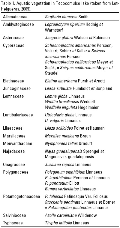
The state of Hidalgo has a distinctive biodiversity due to its location between two physiographic regions, the "Eje Neovolcanico" and the "Sierra Madre Oriental" that are located between the Nearctic and Neotropical biogeographic regions. Tecocomulco Lake lies in the Nearctic region. Its vegetation is mainly S. californicus and it is associated with other communities of emergent, leaf-floating, submerged or free-floating hydrophytes (Table 1).
It is a nesting and reproduction site for migratory birds from northern Mexico, the USA and Canada, some of which remain in the area while others migrate southwards (CONAGUA, 2008). Six resident bird species and 42 migratory bird species have been identified in this area (Table 2). The 32 aquatic migratory species start to arrive on the second week of October and leave during March. Ten migratory species stay during Spring and arrive in Autumn to reproduce, and are joined by numerous Winter migratory flocks (Jiménez-Fernández et al., 2005).
The most diverse and abundant bird species are ducks (12 species). They are all Winter migrants and, because of their abundance, the target for hunters and a source of food for the local inhabitants.
The green and blue winged teals (Anas crecca Linnaeus, 1758 and A. discors Linnaeus, 1766) constitute nearly 70% of the ducks hunted during Autumn and Winter. The American coot (Fulica americana Gmelin, 1978) is the most abundant of the Rallidae family during Winter, with up to 3000 individuals. Another important group is that of the egrets with nine species, five of them migratory. The rest of the 33 species account for only 5% of the abundance.
The SEMARNAT-UMA-2006 ZF, Zona Federal and the DGFS (Direccion General de Fauna Silvestre) of the INE-SEMARNAT, established the hunting season for 2010-2011 for the state of Hidalgo from November 5th, 2010 to March 6th 2011, for 11 bird species: Anas acuta Linnaeus, 1758; A. americana Gmelin, 1789; A. clypeata Linnaeus, 1758; A. crecca, A. cyanoptera Vieillot, 1816; A. discors, A.platyrhynchos Linnaeus, 1758; A. strepera Linnaeus, 1758 and Oxyura jamaicensis Gmelin, 1789 (Jiménez & Juárez, personal communication).
The rapid growth of S. californicus (due to the climate) causes a significant reduction in the lake's surface, despite government efforts to keep it under control. It has become necessary to cut it back, while taking care of the natural habitats for birds, amphibians and reptiles.
Tecocomulco Lake is an "Area of Importance for Bird Conservation" (AICAS, acronym in Spanish) as well as a RAMSAR site. For management and preservation purposes, several limnological and environmental impact studies have been carried out. The programme for Ecological Restoration of the Tecocomulco Lake includes specific steps to safeguard the aquatic animal species that have been assigned protection status in the Mexican legislation (NOM-059-SEMARNAT, 2001), through rescue and relocation if they are affected by the tule cuts, and in accordance with management measures. The programme is focused on aquatic migratory and resident bird species of the Anatidae (Anas acuta, A. discors and A. americana), Rallidae, Podicipedidaea and Ardei-dae families, the fish Menidia jordani Woolman, 1894 (charal), and the amphibians Ambystoma mexicanum Shaw et Nodder, 1798 (ajolote) and Rana catasbeiana Shaw, 1802 (bull frog) (Consejo Estatal de Ecologia del Gobierno del Estado de Hidalgo). The goal of this programme is to reduce mortality to less than 5%.
Integrative studies of inland water bodies that consider environmental conditions such as hydrology, biology, climatological phenomena and management aspects, are scarce.
El Niño is an erratically cyclic climatic phenomenon that occurs in 2 to 7 year cycles. It changes the patterns of oceanic and atmospheric circulation and affects both coastal and inland areas, as a result of the modifications it generates in the meridional and zonal cells that affect tropical and equatorial regions, respectively. These, in turn, regulate the amount of rainfall and the thermal conditions of both coastal and continental regions. Mexico is one of the countries where the ENSO (three phases: El Niño, La Niña and Neutral) generates disturbances (Adams et al., 2003; Magana et al., 2004).
However, studies on the influence of the El Niño and La Niña events on inland water bodies are scarce in Mexico. Alcocer & Lugo (2003) found empirical evidence that the El Niño and La Niña events affect the limnological dynamics of Lake Alchichica, Mexico. Another example of climatic disturbances of the ENSO was found in a high altitude lake in Chile during the 1986-1987 event, when a significant decrease in volume was recorded (Dorador et al., 2003). However, Adams et al. (2003) mentioned that the ENSO benefits some states in Mexico, especially with respect to agriculture. Based on the above, this paper describes the effect of climatic variations on the behaviour of the surface of Tecocomulco Lake in terms of the El Niño/La Niña oscillation, and how it affects agricultural activities. Examples are presented with figures published elsewhere by the authors of this paper, in order to emphasize the effect of the ENSO phenomenon on Mexican inland waters.
MATERIALS AND METHODS
Tecocomulco Lake is in the state of Hidalgo, in the north-western region of the Great Basin of the Valley of Mexico. Its basin covers 564 km2 or 5.49% of the total area of the great basin (CNA, 2002). It lies between 19°42'13.7" and 19°59'30" N, and between 98°11'46.2" and 98°27'30" W (Fig. 1). It is endorreic, with diverse fluvial inputs (from the rivers Cuatlaco, Tepozan, Toronjil and Canoas) that carry small amounts of water in response to a low precipitation, a high evaporation and a high soil permeability. The first two rivers, however, are permanent. According to Huizar-Álvarez & Ruíz-Gonzalez (2005), the lake has several underground water sources. Those with the largest flows are the Alcantarillas, Reposan, Rancho Nuevo, Piedra Ancha and the Mexicano, with flows that decrease during the dry months. These authors also indicated that it is a shallow lake, with a mean depth of 70 cm, and a variable surface area sometimes reaching 27 km2. De la Lanza-Espino & Gómez-Rodríguez (2005) considered it can extend to 35 km2 in response to the intense rainfall generated by a moderate to strong La Niña phenomenon, as that of 2001.
The origin of the lake is volcanic-tectonic and it is surrounded by faults running in a NE-SW direction (García-Palomo & Macias-Vázquez, 2005). A network of channels has been built on the plains to stop the agricultural fields from flooding.
Its climate is temperate sub-humid, with four local subtypes and Summer rains, and a few areas with a semi-arid climate (Caballero-Miranda et al., 1999). Mean annual precipitation is 700 mm, with an altitudinal spatial distribution and a maximum evapo-transpiration in May.
Depending on the depth and topography of the lake, different plant associations are present: Schoenoplectus californicus is the main emergent hydrophylous plant, whereas Typha latifolia Linnaeus (common cattail) and Schoenoplectus americanus Persoon, Volkart, Schinz et Keller (chairmaker's bulrush) are important in areas clearly altered by humans. There are dense stands of Scirpus californicus Meyer in permanently covered areas. Najas guadalupensis Sprengel (southern water nymph), Potamogeton foliosus Rafinesque (leafy pondweed) and Stuckenia pectinatus Linnaeus et Bberner (sago pondweed) are found in open areas and among the tule. Floating species are Lemna gibba Linnaeus (swollen duckweed). Polygonum punctatum Elliott (dotted smartweed), P. lapathifolium Linnaeus (curlytop knotweed) and Lilaea subulata Humboldt et Bonpland (awl-leaf lilaea) are present along the margins. Azolla carolineana Willdenow (Carolina mosquito fern) is frequent in seasonally flooded areas.
Forests with plant associations of pine-oak (Pinus teocote Schiede ex Schlecht et Cham-Quercus crassifolia Humboldt et Bonpland), pines (Pinus patula Schiede ex Schlechtendal et Champagne-Abies religiosa Schlechtendal et Champagne) and juniper-oak (Juniperus flaccida Schlechtendal, Quercus crassipes Humboldt et Bonpland) are located to the north of the lagoon (Lot-Helgueras & Novelo-Retama, 1978).
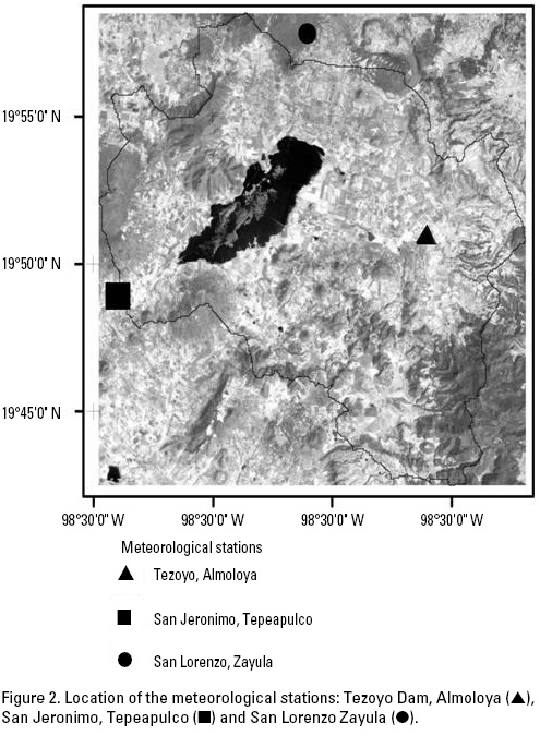
Climatic analysis. The temperature and precipitation data recorded from 1971 to 2000 at the three meteorological stations of San Lorenzo, San Jeronimo and Tezoyo Dam (Fig. 2) were considered alongside the inter-annual frequency of El Niño and La Niña during the same 30 years, in order to detect possible associations. The presence and intensity of the El Niño and La Niña were recorded through the Multivariate ENSO Index. The El Niño Southern Oscillation (ENSO) is the most important coupled ocean-atmosphere phenomenon to cause global climate variability on inter-annual time scales. Here, we attempt to monitor ENSO by basing the Multivariate ENSO Index (MEI) on the principal six observed variables over the tropical Pacific. These six variables are sea-level pressure (P), zonal (U) and meridional (V) components of the surface wind, sea surface temperature (S), surface air temperature (A) and total cloudiness fraction of the sky (C). These observations have been collected and published in the ICOADS (International Comprehensive Ocean-Atmosphere Data Set) for many years. The MEI is computed separately for each of twelve sliding bi-monthly seasons (Dec/Jan, Jan/Feb, Nov/Dec). After spatially filtering the individual fields into clusters (Wolter, 1987), the MEI is calculated as the first unrotated Principal Component (PC) of the six observed fields combined. This is accomplished by normalizing the total variance of each field first, and then performing the extraction of the first PC on the co-variance matrix of the combined fields (Wolter & Timlin, 1993). In order to keep the MEI comparable, all seasonal values were standardized with respect to each season and to the 1950-93 reference period. The MEI is extended during the first week of the following month based on near-real time marine ship and buoy observations (courtesy of Diane Stokes at NCEP), and is summarized into ICOADS-compatible 2-degree monthly statistics at NOAA-ESRL PSD. Caution should be exercised when interpreting the MEI on a month to month basis, since the input data for updates are not as reliable as COADS, and the MEI has been developed mainly for research purposes. Negative MEI values represent the cold ENSO phase (La Niña) and positive MEI values represent the warm phase (El Niño) (NOAA http://www.cdc.noaa.gov/people/klaus.wolter/MEI/mei.html).
De la Lanza-Espino & Gómez-Rodríguez (2005) used satellite images (LANDSAT) taken during the dry and rainy seasons of different years, and integrated the results with the GIS Arcview 3.2, in order to determine the short-term variations of the water surface, the vegetation distribution and land use changes.
The surface of Tecocomulco Lake undergoes great changes. There are large desiccated areas and the type of vegetation varies according to the water level. It is to be expected that the distribution of emerged hydrophylous plants should also change inter-annually. In order to estimate these changes in the lake surface throughout 30 years, the following LANDSAT satellite images were used: LANDSAT MSS, November 23rd 1973; LANDSAT MSS, October 30th 1985; LANDSAT MSS, November 21st 1990; LANDSAT ETM+, March 21st 2000; LANDSAT ETM+, August 20th 2002.
After co-registration of the images, they were visually interpreted and the outline of the lagoon was drawn on screen. To assess the nature of the changes, the differences between the normalized vegetation indices (NDVI) for 1985 and 2002 were analyzed. Unsupervised classifications were performed in order to discriminate between different types of cover within the lake.
The tule in the lake was cut back both manually and mechanically, with care in order to minimize adverse effects on migratory and resident birds, amphibians and reptiles. Vulnerable nests and chicks were moved to the new nesting places that had been prepared in order to maximize nest survival and avoid abandonment by the adult birds, therefore minimizing mortality rates.
Nests, chicks and juvenile birds of the 12 families that nest in the area (Podicipedidae, Pelecanidae, Phalacrocoracidae, Ardei-dae, Threskiornithidae, Rallidae, Charadridae, Recurvirostridae, Anatidae, Phalaropodidae, Laridae and Alcedinidae) were selected for rescue and relocation. The following aquatic fauna was also included (Ardea herodias Linnaeus, 1758; Rallus longirostris Boddaert, 1783; Anas acuta; A. discors; A. americana; Aythya af-finis Boie, 1822; Ambystoma mexicanum; A. tigrinum Green, 1825; Rana moctezuma Baird, 1854; R. catesbeiana Shaw, 1802; Mycte-roperca jordani Jenkins et Evermann, 1889 and Ciprinus carpio Linnaeus, 1758. In order to rescue amphibians and reptiles, it was necessary to identify the areas where most were present. This was done carefully when cutting back the tule, displacing them so that they would hide and survive. It was especially important to relocate individuals of A. mexicanum, A. tigrinum, R. moctezuma, R. catesbeiana, Algansea tincella Valenciennes, 1844 (xouilin), Girardinichthys viviparous Bustamante, 1837 (cuitlapetotl), Chirostoma humboldtianum Steindachner, 1894 (amolotl), C. jordani (Woolman, 1894) and C. carpio. This last fish species must be eradicated as it represents a menace to the delicate ecosystem of Tecocomulco Lake.
The impact was assessed after relocation and other actions were taken, including environmental education.
RESULTS AND DISCUSSION
The meteorological station near the lake, San Jeronimo, recorded a tendency to a temperature increase during 1971-2000, particularly during the 1990s (Fig. 3). It recorded annual mean temperatures of 12.1°C in 1977 and 13.7°C in 1998, associated only with the presence of the El Niño in its longest period (1990-1995) and in 1998. The total annual precipitation was markedly variable, with the highest records coinciding with the El Niño of 1983 and 199293. However, a marked decrease was recorded in 1998-1999 under extreme conditions of El Niño followed by a La Niña.
According to Magana et al. (2004), the Winter rains were more intense and the Summer rains were weaker during the El Niño period, with the opposite taking place during the La Niña years.
Some Winter rains were associated with El Niño events (Fig. 4). Although the correspondence is not precise, it can be seen that in the Winter of 1978-1979, notwithstanding a low index (0.8), there was a significant increase in precipitation as occurred during the longest El Niño period of 1990-1993. The MEI indices corresponded to a medium El Niño.
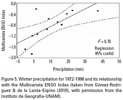
The opposite situation was recorded with the La Niña, although it was only with the most negative indices (-2.0) that there was less precipitation during the Winter, as occurred in 19731974, 1975-1976, 1988-1989 and 1999-2000. This is corroborated by the significant correlation (r = 0.705) shown in Figure 5. The association was not clear in the case of the Summer rains, although precipitation increased with less negative indices or less intense La Niña's, such as those of 1974, 1984, 1985, 1989 and 1999.
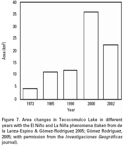
Rainfall decreased significantly during the Summer and Winter of the El Niño 1982-1983 (which had a MEI of 0.063-3.148, one of the highest measured last century), as occurred in 1973 when the surface of Tecocomulco Lake was scarcely 4.5 km2 (Figs. 6 and 7). It is presumed that from 1982-1983 until 1985, when the surface area was only 11.3 km2, the ENSO influenced the decrease in surface area, although in 1985 La Niña was predominant with an index of -0.71 to -0.73 and there was a rainy Summer. The year 2000, when the lake had a surface area of 36 km2, was a La Niña year, with an index of -0.016 to -1.133, which was felt even in 1999 (MEI of -0.384 to -1.208) when the Summer precipitation was greater and led to an increase in surface area that remained until 2000. The surface area decreased slightly in 2002, corresponding to a moderate El Niño event. Between 2001 and 2002, Tecocomulco Lake had a depth of 0.75-1 m and a 37% reduction in surface area. This is greater than the 6% reduction calculated by Dorador et al. (2003) for Chungara Lake in Chile, where the maximum depth is 35 m. The high temperature, the scarce precipitation, the high evaporation and the shallowness of Tecocomulco Lake are the possible answer to the marked reduction in surface area observed during the ENSO of 1982-1983. However, this requires further study and corroboration during other ENSO phenomena.
Climatic variations impose a challenge to the management of this area, which not only has a very high biodiversity, but also human communities. The land has been used mainly for agriculture, and the marked variations in the surface area of the lake change the area of agricultural land from year to year. The impact of this kind of agricultural practice on wildlife is yet to be studied.
The management of S. californicus in order to maintain areas of clear water has taken into account the nesting places of birds.
The goal of this programme is to reduce the mortality of chicks to under 5%.
Given that the basin area is highly deforested, erosion is high. According to Ruíz-Gonzalez & Huizar-Álvarez (2005), soil loss in the sub-basin amounts to approximately 40 thousand tons and, if deposits from erosion continue at a rate of 3.4 cm/m2/year, Tecocomulco Lake could be completely silted up in 18 years. Agricultural activities have increased by 9.3% over approximately three decades, and there has been a wide variation in the lake surface area with only 21.2% of unaltered vegetation (Fig. 8).
Based on the previous analyses, it is possible to state that the surface of Tecocomulco Lake is closely associated with the variability of the climate. This has allowed agriculture to advance, particularly in the El Niño years events, with a gradual tendency to a reduction in the lake area as a result of the construction of dikes that delimit the land gained by agricultural activities, and prevent flooding and increases in the water level up to the usual surface during the rainy years, as occurs at present. This situation will result in a loss of aquatic vegetation surface and of bird habitats, for resident as well as migratory species, in spite of efforts directed towards the conservation of reproduction, growth and feeding areas. This imbalance between environmental conservation and anthropogenic activities in a relict lake will require strict normative measures to regulate the legal management of this RAMSAR site.
ACKNOWLEDGEMENTS
The authors thank J.C. Gómez Rojas for helping to edit the text and to prepare the illustrations, Andrea Raz-Guzmán for English translation, Noemi Chávez for the reviewed bird composition, Dra Alantida Coll-Hurtando Editor of Investigaciones Geograficas scientific review and Dra. Elena Centeno García Director of Instituto de Geologia to permit us the figure and tables reproductions in this paper.
REFERENCES
Adams, R. M., L. L. Houston, B. A. McCarl, M. Tiscareno, J. Matus & R. F. Weiher. 2003. The benefits to Mexican agriculture of an El Niño-southern oscillation (ENSO) early warning system. Agricultural and Forest Meteorology 115: 183-194. [ Links ]
Alcocer, J. & A. Lugo. 2003. Effect of El Niño on the dynamics of Lake Alchichica, central Mexico. Geofísica Internacional 42 (3): 523-528. [ Links ]
Caballero-Miranda, M., S. Lozano-García, B. Ortega-Guerrero, J. Urrutia-Fucugauchi & J. L. Macías-Vázquez. 1999. Environmental characteristics of lake Tecocomulco, northern basin of Mexico, for the last 50,000 years. Journal of Paleolimnology 22: 399-411. [ Links ]
CNA (Comisión Nacional del Agua). 2002. Determinación de la Calidad del Agua en el Acuífero de Tecocomulco, Hgo. Gerencia de Aguas Subterraneas. (http://www.conagua.gob.ma/CONAGUA07/Noticias/DR_1319.pdf). [ Links ]
C0NAGUA (Comisión Nacional del Agua). 2008. Comisión de Cuenca de la Laguna de Tecocomulco, 2008. Gobierno del Estado de Hidalgo, México. 19 p. [ Links ]
De la Lanza-Espino, G. & G. Gómez-Rodríguez. 2005. Analysis of short term geo-environmental evolution of an endorrheic basin using satellite images: the case of Tecocomulco lagoon, Mexico. Investigaciones Geográficas 58: 66-79. [ Links ]
Dorador, C., R. Pardo & I. Vila. 2003. Variaciones temporales de parametros físicos, químicos y biológicos de un lago de altura: el caso del lago Chungara. Revista Chilena de Historia Natural 76 (1): 15-22. [ Links ]
García-Palomo, A. & J. L. Macías-Vázquez. 2005. Estratigrafía y geología estructural de la región de Apan: subcuenca de Tecocomulco, Estado de Hidalgo. In: Huizar-Álvarez, R., E. J. Jiménez-Hernández & C. Juárez-López (Eds.). La Laguna de Tecocomulco. Instituto de Geología, Universidad Nacional Autónoma de México, México, pp. 21-32. [ Links ]
Gómez-Rodríguez, G. & G. de la Lanza-Espino. 2010. Laguna de Tecocomulco y sus variantes climáticas, hidrologícas y de vegetación a través de imágenes de satélite. In: Aguirre-Gómez, R. (Ed.). Utilización de sensores remotos en el estudio de los remanentes de cuerpos de agua en el Valle de México. Instituto de Geografía, Universidad Nacional Autónoma de México, pp. 91-11. [ Links ]
Huizar-Álvarez, R. & J. E. Ruíz-González. 2005. Aspectos físicos y socio-económicos de la subcuenca de Tecocomulco. In: Huizar-Álvarez, R., E. J. Jiménez-Fernández & C. Juárez-López (Eds.). La Laguna de Tecocomulco. Instituto de Geología, Universidad Nacional Autónoma de México, pp. 9-20. [ Links ]
Instituto Mexicano de Tecnología del Agua (IMTA). 2006. Extractor Rápido de Información Climatológica (ERIC). Servicio Meteorológico Nacional, México. http://www.csva.gob.mx/sih/info/pag_ficha_datos.php?xficha=905. [ Links ]
Jiménez-Fernández, E.J., C. Juárez-López & L. Alonso-Montesinos. 2005. Ornitofauna y fauna acuática de la Laguna de Tecocomulco: aspectos de conservación aprovechamiento. In: Huizar-Álvarez, R., E. J. Jiménez-Fernández & C. Juárez-López (Eds.). La Laguna de Tecocomulco. Instituto de Geología, Universidad Nacional Autónoma de México, pp. 179-191. [ Links ]
Lot-Helgueras, A. & A. Novelo Retama. 1978. Laguna de Tecocomulco, Hidalgo. Guías Botánicas de Excursiones en México. Sociedad Botánica de Mexico. 19 p. [ Links ]
Lot-Helgueras, A. 2005. Vegetación acuática de la laguna de Tecocomulco. In: Huizar-Álvarez, R., E. J. Jiménez-Fernández & C. Juárez-López (Eds.). La Laguna de Tecocomulco. Instituto de Geología, Universidad Nacional Autónoma de México, pp. 141-147. [ Links ]
Magana, V., J. L. Pérez, J. L. Vázquez, E. Carrisoza & J. Pérez. 2004. El Niño y el Clima. In: Magana, V. (Ed.). Los Impactos de El Niño en México. UNAM, SEP-CONACyT, IAI, EMBU, México, pp. 23-68. [ Links ]
NOAA. 2008. (http://www.cdc.noaa.gov/people/klaus.wolter/MEI/mei.html). [ Links ]
NOM-059-SEMARNAT. 2001. Norma Oficial Mexicana para la Protección ambiental-especies nativas de Mexico de flora y fauna silvestres categorías de riesgo y especificaciones para su inclusión, exclusión o cambio lista de especies en riesgo. [ Links ]
Ruíz-González, J. E. & R. Huizar-Álvarez. 2005. La erosión en la subcuenca de Tecocomulco. In: Huizar-Álvarez, R., E. J. Jiménez-Hernández & C. Juárez-López (Eds.). La Laguna de Tecocomulco. Instituto de Geológia, Universidad Nacional Autónoma de México, pp. 73-88. [ Links ]
Wolter, K. 1987. The Southern Oscillation in surface circulation and climate over the tropical Atlantic, Eastern Pacific, and Indian Oceans as captured by cluster analysis. Journal Climate Applied Meteorology 26: 540-558. [ Links ]
Wolter, K. & M. S. Timlin. 1993: Monitoring ENSO in COADS with a seasonally adjusted principal component index. Proceedings of the 17th Climate Diagnostics Workshop, Norman, OK, NOAA/NMC/CAC, NSSL, Oklahoma Clim. Survey, CIMMS and the School of Meteor., University of Oklahoma, pp. 52-57. [ Links ]

