


 nueva página del texto (beta)
 Inglés (pdf)
 Artículo en XML
 Referencias del artículo
 Enviar artículo por email
 Citado por SciELO
  Similares en
SciELO
Similares en
SciELO 
 Permalink
Introduction
Protected areas are a cornerstone of current conservation efforts and will continue to play an important role under climate change and biodiversity loss (Bicknell et al., 2017). In these areas, the high biodiversity “provide multiple services to humans, including climate regulation, nutrient cycling, and stable supplies of fresh water” (Collins & Mitchard, 2017). As such, managing them well is vital for human well-being and the continued functioning of the global ecosystem and economy. The ecosystem services (ES) that protected areas provide to humans are dependent on the integrity and quality of the natural environment (Rannow et al., 2014). Putting in place appropriate management practices in these areas is thus a high priority. In protected areas, soil functions support the delivery of ES, such as soil carbon sequestration, climate regulation, water regulation (Amundson et al., 2015), food production and security (White et al., 2012), and biodiversity preservation (Ibáñez et al., 2012). Soil ES depend on soil properties and interactions and are greatly influenced by soil use and management. Soil erosion and decreased soil carbon and water retention lead to soil degradation, which is a serious global challenge to ecosystem sustainability (Adhikari & Hartemink, 2016). They also play a key role in at least seven of the nine planetary boundaries (Bouma, 2014). Despite their importance, soils are often an overlooked component in studies on ES and policy decisions (Adhikari & Hartemink, 2016).
To design management strategies that ensure ecosystems to deliver multiple ES, it is necessary to understand the interactions between their abiotic and biotic components. Smith et al. (2015) mention that “this knowledge is critical to inform the sustainable long-term management of natural resources, to manage trade-offs and synergies between different services, and to design ecosystem management strategies”. The ES approach offers opportunities to develop broader constituencies for conservation, expand the possibilities of influencing decision-making (Reyers et al., 2013), and promote the sustainable management of ecosystems outside protected areas (Smith et al., 2015).
Climate change will make the management of protected areas even more challenging. Thus, it is important to adopt a transparent and scientifically rigorous monitor, as well as to reassess and respond to change and alter management (Tanner et al., 2017). This approach will give decision-makers in policy, practice, and business enough evidence to enable them to assess the impact of different management decisions (Smith et al., 2015). Assessing the impacts of policies and decisions on the sustainable use of natural capital and the provision of ES is essential for testing assumptions and enabling ongoing learning and adaptive management (Guerry et al., 2015). It is a fundamental information to understand how the biotic and abiotic attributes of natural capital influence the capacity of ecosystems to supply different services (Smith et al., 2015). However, almost all forest restoration initiatives have lacked systematic monitoring, thereby eliminating the possibility of assessing the effectiveness of forest restoration efforts and learning from experience (De Luca et al., 2010; Stanturf et al., 2019).
The Iztaccíhuatl-Popocatépetl National Park (NP) is the most important remnant of high-mountain conifer forests and grasslands in central Mexico. It provides ES related to water, carbon sequestration, and erosion regulation, which are vital to the survival of Mexico City, one of the world’s largest metropolises. Sometimes, external drivers such as management practices push the ecosystem into a state where one ES is favored over another (Bennett et al., 2009). Such is the case of the Iztaccíhuatl-Popocatépetl NP’s management program, where it was decided to give priority to a “Rainwater Harvesting” project aiming to increase aquifer recharge. In this project, government, companies, and civil society promoted the construction of ditches without defining criteria for the conservation or recovery of water bodies (Comisión Nacional de Áreas Naturales Protegidas [Conanp], 2015).
Ditches have been constructed for thousands of years to collect rainwater in arid and semi-arid areas (Critchley & Siegert, 1991). This practice is used to reduce the length of water course (Dollinger et al., 2015), collect runoff water and reduce erosion processes (Pizarro et al., 2004), improve the efficiency of rainwater use (Bulcock & Jewitt, 2013), conserve water and support biomass production and the afforestation of degraded lands (Singh et al., 2013), and control runoff water in urban areas (Chahar et al., 2012). Although no study to date has shown the benefits of this practice to soil quality, various studies have found that it has negative environmental impacts, such as reduced soil moisture retention, possible mineralization of organic carbon, and erosion of sediments on the ridges (Cotler et al., 2013, 2015; Galván-Díaz, 2016; Ramírez-Santiago, 2016). In response to these studies, Mexico’s National Forestry Commission (Comisión Nacional Forestal, [Conafor]) advised against constructing ditches in the Trans-Mexican Volcanic Belt, and in 2015, it modified its operating rules accordingly (Conafor, 2018a). However, ditches are still being constructed in other protected natural areas and in other forest areas in the country (Cotler et al., 2020).
The construction of ditches results in many negative impacts. Among them, the excavation of the first 40 cm of soil for the construction of the ditches removes large amounts of material that is exposed to the erosive effect of the rain and can mobilize between 60 ton/ha-123 ton/ha (Cotler et al., 2015). At this depth, 50% of the soil organic carbon is stored (Balbontin et al., 2009). The exposure of removed soil exposure can cause its mineralization (Geissen et al., 2013; Robert, 2001), so the removal can cause the exposition of 0.4 ton/ha-6.3 ton/ha of soil organic carbon, which is susceptible to mineralization (Cotler et al., 2015). The mineralization process releases CO2 into the atmosphere, turning the soil into a net emitter of this gas instead of a sink (Bedard-Haughn et al., 2006; Robert, 2001).
In terms of hydrologic regulation, ditches are classified under different categories: a hydrological-forestry practice (Pizarro et al., 2004), a mechanical practice (Loredo et al., 2005), or a water harvesting technique (Jha et al., 2014; Oweis et al., 1998; Singh et al., 2013). Some authors even consider it a solution for the recharge of aquifers (Cota et al., 2011), but there is very little field evidence of its effectiveness due to the difficulty of measuring the recharge (Dagès et al., 2009); and due to the negative impacts identified at the basin level, it is considered an issue that has to be carefully addressed because the ditches will change the water balance within a watershed (Glendenning et al., 2012). In addition, ditches do not improve the soil moisture retention capacity, and given the complexity of the soil-plant interactions, the best way to conserve soil moisture is by minimizing its disturbance (Delgado et al., 2013; Hartfield et al., 2001). Monitoring and scientific assessment are an essential pathway to building an adaptive management framework that promotes collaborative learning and enables transformations (Salafsky et al., 2002; Wernes et al., 2021).
In this context, this study assesses the impact of constructing ditches on the hydrological regulation (infiltration), erosion regulation, and carbon sequestration ecosystem services provided by the Iztaccíhuatl-Popocatépetl NP at the regional scale, using both secondary data analyzed in geographic information systems and primary data collected in the field by Galván-Díaz (2016) and Ramírez-Santiago (2016).
Materials and methods
Study area and description of ditches in the Iztaccíhuatl-Popocatépetl NP
The Iztaccíhuatl-Popocatépetl NP is located in the center of the Trans-Mexican Volcanic Belt at an elevation between 3000 m. a. s. l. and 5480 m. a. s. l., covering an area of 39 819.1 ha. In this mountain range, the Nearctic and Neotropical realms meet, which results in high ecosystem diversity and biological richness, thereby promoting endemism and the presence of populations typical of temperate zones (Conanp, 2013). The dominant soil types are andosols (51.6%) and luvisols (23.8%) (Instituto Nacional de Estadística y Geografía [INEGI], 2009).
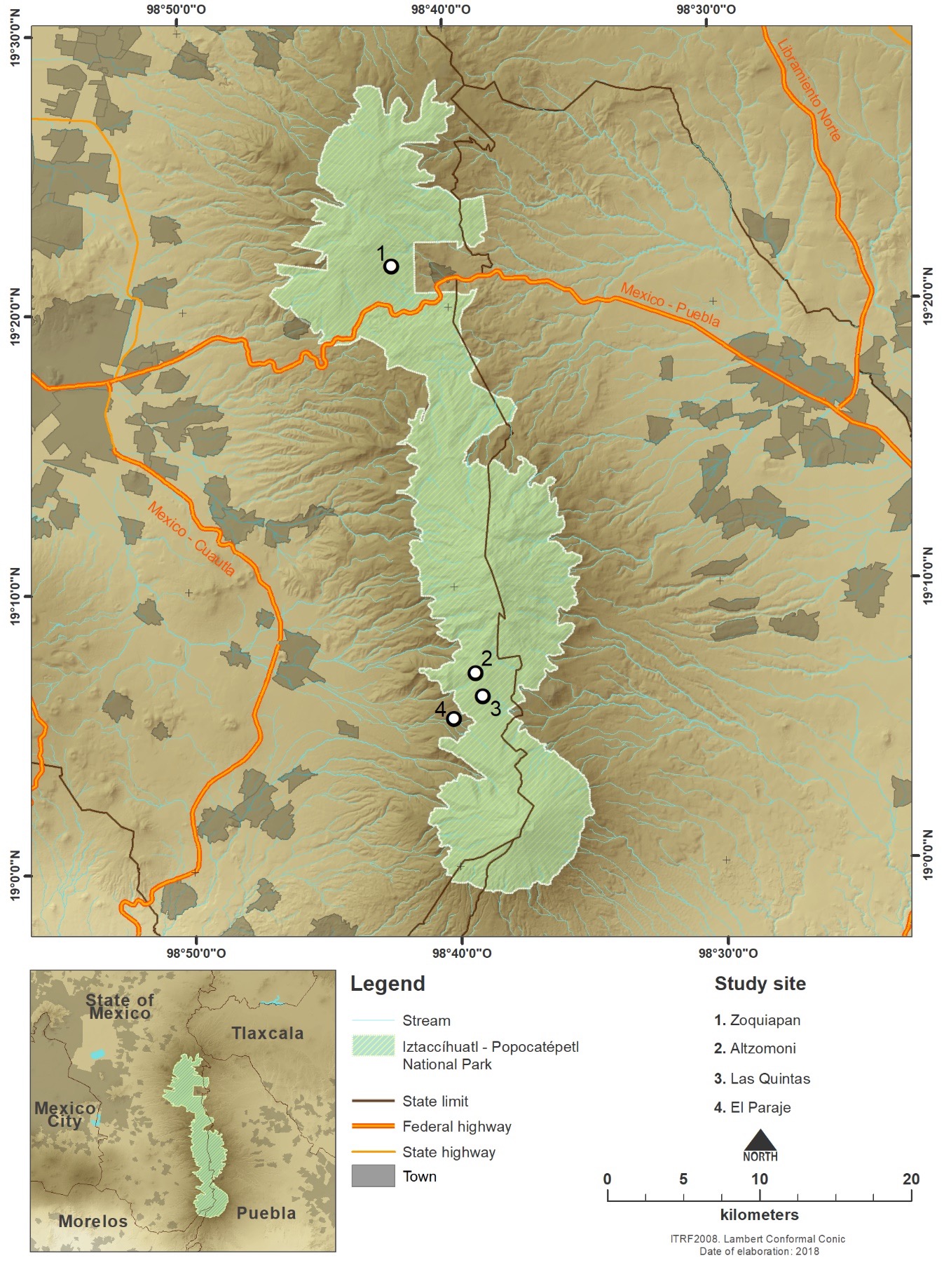
This protected area is the most important remnant of high-mountain conifer forests and grasslands in central Mexico. In this area, infiltration and runoff processes allow the formation of rivers and recharge of the aquifers that supply water to the populations of Mexico City and the city of Puebla. Despite this, water scarcity has become a very serious issue, with the flow of water from springs, wells, and runoff decreasing from day to day because of both overdemand and unfavorable conditions for aquifer recharge. There is limited information available on this issue (Conanp, 2013). This area’s strategic value in providing ES, particularly water provisioning to millions of people and main agricultural valleys, led to the implementation of the “Water Factory” project (Conanp, 2013), which consisted in constructing water-infiltration basins (ditches) on mountain slopes. This project was a joint initiative of the social, public, and private sectors (Figure 1).
Source: Autor’s own elaboration.
Figure 1 Study area and location of ditches in the Iztaccíhuatl-Popocatépetl National Park, Mexico. Figure based on data from Conanp (2015).
These basins (ditches) were constructed for the purpose of recharging the aquifers, but with no scientific information or basis to support this decision, and without considering that working the soil may alter the ES it provides, namely carbon sequestration, water infiltration, and erosion regulation.
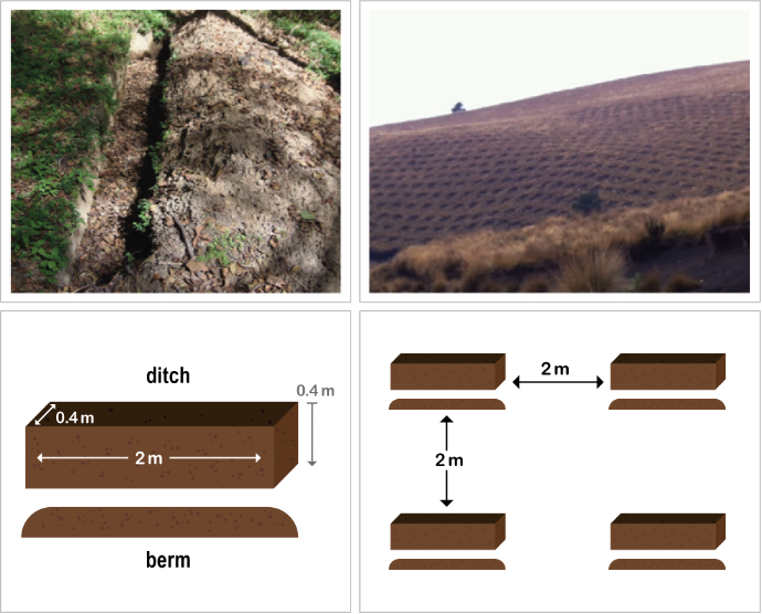
The constructed ditches are excavations (0.4 m wide × 0.4 m deep × 2 m long) along contour lines and perpendicular to the slope, separated from each other by 2 m and alternating so that each ditch is opposite to the space between ditches in the rows above and below (Conafor, 2018b).
The extracted material was thrown up into a ridge along the lower edge of the ditch, where reforestation activities were carried out (Figure 2).
Source: Autor’s own elaboration.
Figure 2 Ditch (left), ditches on a slope (right), and ditch construction design (below) in the Iztaccíhuatl-Popocatépetl National Park, Mexico.
A total of 3786.77 ha of drainage ditches were constructed in this protected area, covering 9.5% of the NP’s total area. These ditches are located at the following sites: Zoquiapan, Altzomoni, El Paraje, and Paso de Cortés (Table A, annexes). Their construction was funded by a non-profit organization (Pronatura México), government entities (Conanp and Conafor) and private corporations (Grupo Bimbo, The Coca-Cola Company, Volkswagen, and Grupo Televisa) (Ramírez-Santiago, 2016).
Ecosystem Services framework
The ES framework is a powerful policy tool since it makes the invisible benefits of nature become visible to society (Lara-Pulido et al., 2018). The importance of ES in policy making is recognized at the highest level of the Mexican government, where they are considered a pillar of sustainable development (Diario Oficial de la Federación [DOF], 2020). The ES framework aims to provide the tools to enable multiple stakeholders to apply the concept of ecosystem services in their planning and management practices (Maynard et al., 2010). This framework builds an interdisciplinary research bridge between natural science and social science, which can help decision-makers better integrate the concept of ES into decision-making (Potschin-Young et al., 2018; Zhang et al., 2022). The ES framework produces maps of spatial data that identify and illustrate the linkages between ecosystems, ecosystem functions, ecosystem services, and people’s well-being (Johnson et al., 2019; Maynard et al., 2010).
We showed assesses of the impact of ditches on three ES: a) hydrological regulation (infiltration), b) erosion regulation, and c) carbon sequestration. The study analyzes the sites with ditches located in Zoquiapan, Las Quintas, Altzomoni, and El Paraje. Results of small-scale in situ studies, indeed, can provide databases for a regional-scale study on soil ES using the right indicators and suitable models (Heuvelink, 1998). The methodological approach to obtain information on the three ES evaluated is presented in Figure 3 and developed in the next sections.

Water regulation (infiltration) modeling
Many hydrological models are currently used to assess the impact of climate and soil properties on hydrological processes and water resources (Devia et al., 2015). These models can be defined as sets of equations that allow hydrological variables to be estimated based on various parameters describing a particular basin’s characteristics. The two main entries required by all these models are precipitation data and drainage area, but parameters such as soil properties, land-use/land-cover (LULC), the river basin’s topography, soil moisture content, and characteristics of the underground aquifer, among others, are considered as well.
One of these models, the Soil & Water Assessment Tool (SWAT), simulates hydrologic processes that require a large number of spatial and temporal data of different types and sources, integrated in a geographic information system (GIS) environment. This model, currently used worldwide to study the most diverse river basins, comprises a considerable number of parameters and submodels designed to analyze and predict the flow of water, sediments, and agrochemicals (Arnold et al., 2011; Douglas-Mankin et al., 2010). In the SWAT model, water infiltration is defined as the difference between precipitation and runoff and is estimated by the rate at which water enters the first soil horizons until saturation is reached. It was thus necessary, as a first step, to undertake climate modeling (Gabriels et al., 2021).
The SWAT model uses data on elevation, soil type, and LULC, as well as on climate data such as precipitation, solar radiation, relative humidity, wind speed, and temperature. It divides the basin into subbasins, which in turn are divided into hydrologic response units (HRUs); from these, the model estimates a very wide range of variables related to the water cycle, such as runoff, evapotranspiration, infiltration, lateral flow, percolation, sedimentation, and potential erosion, among others. The results of this model are expressed in monthly terms, so the water cycle can be simulated monthly. Implementing the model in a GIS environment allowed water infiltration rate and potential erosion to be estimated in a spatially explicit setting (Table 1).
Table 1 Summarized inputs, processes, and sources used for modeling water (infiltration) and erosion regulation in the Iztaccíhuatl-Popocatépetl National Park, Mexico.
| Information | Input | Source |
| Digital elevation model (DEM) | Official Mexican Digital Elevation Model from INEGI. Mexican Elevation Continuum 3.0 with a 30-m resolution | Mexico’s National Institute of Statistics and Geography (Instituto Nacional de Estadística y Geografía, INEGI) |
| Land-use/land cover | Supervised classification of a Landsat 7-ETM+ image with a 30-m resolution, dated December 3rd 2013 | USGS Global Visualization Viewer (GloVis) https://glovis.usgs.gov/ |
| Soil data Secondary data Field data | Interpretation of vector soil data set, scale 1:250 000 Soil profile data set, Series II, scale 1:250 000 Organic carbon, saturated hydraulic conductivity, and soil structure |
INEGI (2009);
INEGI (2013) Ramírez-Santiago (2016) and Galván-Díaz (2016) |
| Climate data | Precipitation information obtained from the CLICOM database | Climate Computing Project (CLICOM) http://clicom-mex.cicese.mx/ |
Source: Autor’s own elaboration.
Climate data were obtained from 12 stations distributed around the study area (five in Estado de Mexico, four in Puebla, two in Morelos, and one in Hidalgo), hence ensuring adequate spatial coverage and altitudinal range. The daily mean precipitation values and daily extreme temperatures obtained covered between the years 1982-2014. To work with series that were as complete as possible in both space and time, all the precipitation and temperature series available were processed to consistently fill the gaps and extend them starting the Climate Computing Project (Clicom), a climate data management software system developed by the United Nations (Clicom, 2018).
Based on a digital elevation model (DEM) (Table 1), the study area was divided into various subbasins using a threshold value of 68 ha. Each subbasin was in turn divided into HRU, each representing a unique combination of soil type, land cover, and slope. Each subbasin thus contained at least one HRU. Each output variable was predicted separately for each HRU and routed based on the DEM to obtain the subbasin’s total value, allowing greater precision in the spatial description of the water balance.
To determine LULC mapping data, a Landsat 7 ETM+ image (Table 1) was banding-corrected and then atmospherically corrected using FLAASH®. To conduct a maximum-likelihood supervised classification on the Landsat image, regions of interest (ROI) were defined using RapidEye images with a 5-m resolution, dated December 2013. The ROI were located so that samples could be obtained for calibrating and then validating 11 different types of land cover: 1) irrigated agriculture; 2) rain-fed agriculture; 3) urban area; 4) planted forest; 5) temperate forest; 6) area without apparent vegetation, or bare soil; 7) natural grassland; 8) temperate forest with secondary arboreal vegetation; 9) temperate forest with secondary shrub vegetation; 10) high-mountain grassland; and 11) snow.
As mentioned above, the SWAT model also requires data on LULC classes. Because of the very large number of characteristics defining each of these types, calibrating them at the scale of the study area was not feasible. The LULC classes identified in the study area were thus assigned to the model’s default categories.
Erosion regulation modeling
Erosion caused by rainfall and runoff was computed by the modified universal soil loss equation (MUSLE). The USLE predicts average annual gross erosion as a function of rainfall energy; in the MUSLE, rainfall energy is replaced with a runoff factor which improves the sediment yield prediction (Neitsch et al., 2011). For this model, field data on soil organic carbon (SOC), soil structure, and saturated hydraulic conductivity were used (Table 2).
Table 2 Soil and ecological characteristics of the study sites in the Iztaccíhuatl-Popocatépetl National Park, Mexico. * Classes: FAO (2015).
| Site | Soil Conditions | Slope (%) | Vegetation | Elevation (m. a.s.l.) | |||
| Texture | Organic carbon (%) | Bulk density (g/cm3) | Infiltration rate (mm/min)* | ||||
| Altzomoni | Loam sandy | 3.3 | 0.95 | 17.45 (fast) | 15-20 | Grassland; Forest (Pinus hartweggi) | 3774-3800 |
| Zoquiapan | Sandy loam | 7.7 | 0.83 | 19.4 (very fast) | 27 | Forest (Pinus hartweggi) with shrub species | 3445 |
| El Paraje | Sandy loam | 2 | 0.92 | 11.47 (medium) | 25 | Grassland | 3500 |
| Las Quintas | Loam sandy | 3.8 | 0.8 | 12.7 mm/min (fast) | 30-35 | Forest (Pinus hartweggi) with shrub species | 3793 |
Note: Based on data from Galván-Díaz (2016) and Ramírez-Santiago (2016).
Source: Autor’s own elaboration.
Soil types were reinterpreted by relating soil profile data generated by Mexico’s National Institute of Statistics and Geography (Instituto Nacional de Estadística y Geografía [INEGI], 2013a) to the dominant soils. Then, soil profile characteristics were calibrated based on field studies carried out by Ramírez-Santiago (2016) and Galván-Díaz (2016).
Carbon sequestration modelling
The ES of carbon sequestration was quantified exclusively from field data on the impact of ditches on the carbon content that can potentially mineralize. In the study area, the first soil horizons have a higher soil organic carbon (SOC) content (Galván-Díaz, 2016; Ramírez-Santiago, 2016), which becomes exposed to the weather once the soil is extracted and thrown up into a ridge.
For each ditch, the amount of soil removed (t/ha) and the amount of SOC exposed to the weather (t) were calculated following these steps (Cotler et al., 2015):
Volume of soil horizon (cm3) = (Ditch width: 40 cm) * (thickness of soil horizon [cm]) * (Ditch length: 200 cm)
Weight of removed soil (kg) = (Volume of soil horizon [step 1]) * (BD [g/cm3] / 1000)
where BD = the bulk density of each soil horizon.
3. The average weight of soil removed (t) was calculated both per ditch and per site based on the number of ditches constructed.
The amount of exposed SOC was estimated following these steps:
where the percentage of SOC is that of each soil horizon. The average exposed SOC (%) was calculated both per ditch and per site.
Results
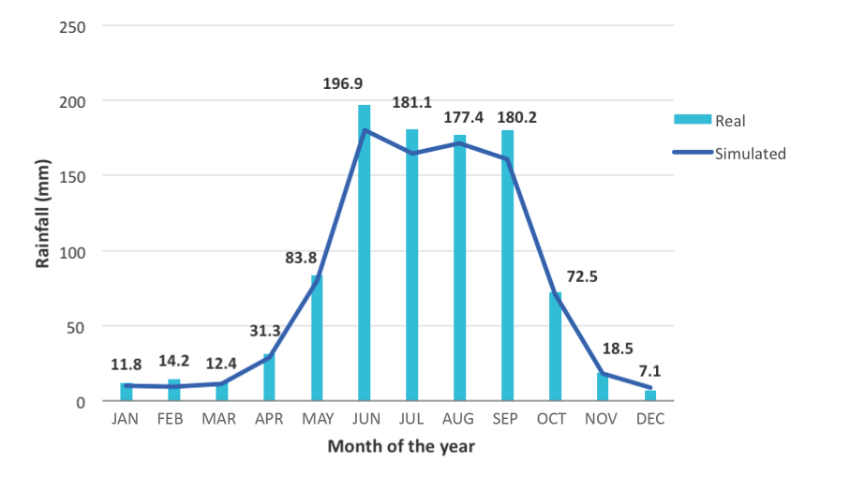
In the study area, between 1982 and 2014, precipitation ranged from 0 mm to 122.5 mm per day and averaged 914.18 mm per year, while temperature ranged from -11.5 °C to 40.5 °C and averaged 14.9 °C. It is worth noting that this precipitation level is consistent with that reported by the Climiforad (2014). Figure 4 compares the simulated precipitation with real precipitation data observed at the 12 climate stations from 1982 to 2014. The SWAT model estimated an average precipitation of 884 mm per year, with a coefficient of determination reaching 99.8%, which indicates that the model correctly replicates the observed data and can be regarded as a good model for predicting the water cycle in the study area.
Source: Autor’s own elaboration.
Figure 4 Monthly rainfall in the Iztaccíhuatl-Popocatépetl National Park, Mexico, between 1982 and 2014. Figure based on data from the Servicio Meteorológico Nacional’s (SMN) Climate Computing (Clicom) database.
Table B (annexes) shows the correspondence between the classes of LULC identified in the study area and the SWAT model’s default categories. It can be observed that temperate forests, forests with secondary shrub vegetation, natural grasslands, and forests with secondary arboreal vegetation dominate in the study area.
In the Iztaccíhuatl-Popocatépetl NP, vegetation types are distributed according to slope exposure and elevation. High-mountain grassland is the main vegetation type between 4000 m. a. s. l. and 4500 m. a. s. l.; conifer forests dominated by Pinus hartweggi are distributed on moister slopes, between 3500 m. a. s. l. and 4000 m. a. s. l.; and conifer forests exhibit a higher diversity of pine species as well as shrub species, between 2300 m. a. s. l. and 3500 m. a. s. l. (Escaramilla, 2007; Franco, 2005).
Reinterpreting INEGI’s soil map with detailed soil profile data (Galván-Díaz, 2016; Ramírez-Santiago, 2016) allowed the study area’s main soil types to be determined, with andosols and luvisols covering more than 75% of the area (Table C, annexes). As mentioned above, the study sites, where ditches were constructed, are located on andosols. These soils are characterized by a high organic content and a very high soil moisture storage capacity (Food and Agricultural Organization of the United Nations [FAO], 2015).
The sites analyzed were located on soils type andosol with grassland and conifer forest vegetation (Table 2).
Water regulation (infiltration) modeling
Average infiltration rate was 319 mm/year in the study area, with large variations between subbasins. Figure 5 and Table 3 show that ditches were constructed in subbasins with highly variable natural infiltration rates, ranging from very low (55 mm/year-183 mm/year in Altzonomi) to very high (439 mm/year-935 mm/year in Las Quintas) (Table 4). Thus, the infiltration capacity of soils was not a criterion for choosing suitable sites for constructing ditches. On the other hand, field data revealed that all study sites had a very high average infiltration rate, from 15.9 mm/min to 18.7 mm/min, indicating suitable natural infiltration conditions (Galván-Díaz, 2016; Ramírez-Santiago, 2016).

Source: Autor’s own elaboration.
Figure 5 Water infiltration in the Iztaccíhuatl-Popocatépetl National Park, Mexico.
Table 3 Infiltration modeling results for each studied subbasin in the Iztaccíhuatl-Popocatépetl National Park, Mexico.
| Vegetation Type | Infiltration Rate in the Subbasin (mm/year) | |
| Altzomoni | Alpine grassland | 55-183 |
| Las Quintas | Temperate forest | 439-935 |
| El Paraje | Alpine grasslands with shrub species | 336-439 |
| Zoquiapan | Temperate forest with shrub species | 336-439 |
Source: Autor’s own elaboration.
Table 4 Modeled potential soil erosion and potential soil erosion caused by the construction of ditches in the Iztaccíhuatl-Popocatépetl National Park, Mexico.
| Site | Simulated Potential Erosion (tons/ha) |
Potential Erosion Caused by the Construction of Ditches (tons/ha) |
Vegetation Type |
| Altzomoni-A | 0.02-7.08 | 421.8 | Grassland |
| Altzomoni-E | 14-33.93 | 381.9 | Grassland |
| Las Quintas-E | 0.02-7.08 | 133.4 | Forest |
| El Paraje-A | 33.93-63.08 | 197.2 | Grassland |
| Zoquiapan-A | 63.08-613.36 | 85.6 | Forest |
Note: Table based on Soil & Water Assessment Tool (SWAT) modeling and field data from Ramírez-Santiago (2016) and Galván-Díaz (2016).
Source: Autor’s own elaboration.
These values are consistent with those reported by García-Hernández et al. (2008) for similar ecosystems (35 mm/min in forests and 22.7 mm/min in grasslands). The construction of ditches can alter infiltration processes in two different ways. On the one hand, once ditches are constructed, deep soil horizons remain on the surface of the ridges which, according to Galván-Díaz (2016), Ramírez-Santiago (2016), and Cotler et al. (2013, 2015), have a higher bulk density, especially in grassland areas. This reduces water infiltration, which has been shown to be negatively correlated with bulk density (Bodhinayake & Cheng, 2004; Chyba et al., 2014; Li et al., 2015). On the other hand, the ditches covered an area of 3548 m2/ha in grasslands and 806 m2/ha in forests, and the construction of ridges led to an additional 1436 m2/ha-2815 m2/ha of grassland and 599 m2/ha-1210 m2/ha of forest being covered by soil. Thus, in total, the construction of ditches caused natural soil conditions to be altered in an area of 4984 m2/ha-6363 m2/ha in grasslands and 1405 m2/ha-2016 m2/ha in forests (Galván-Díaz, 2016; Ramírez-Santiago, 2016).
Erosion regulation modeling
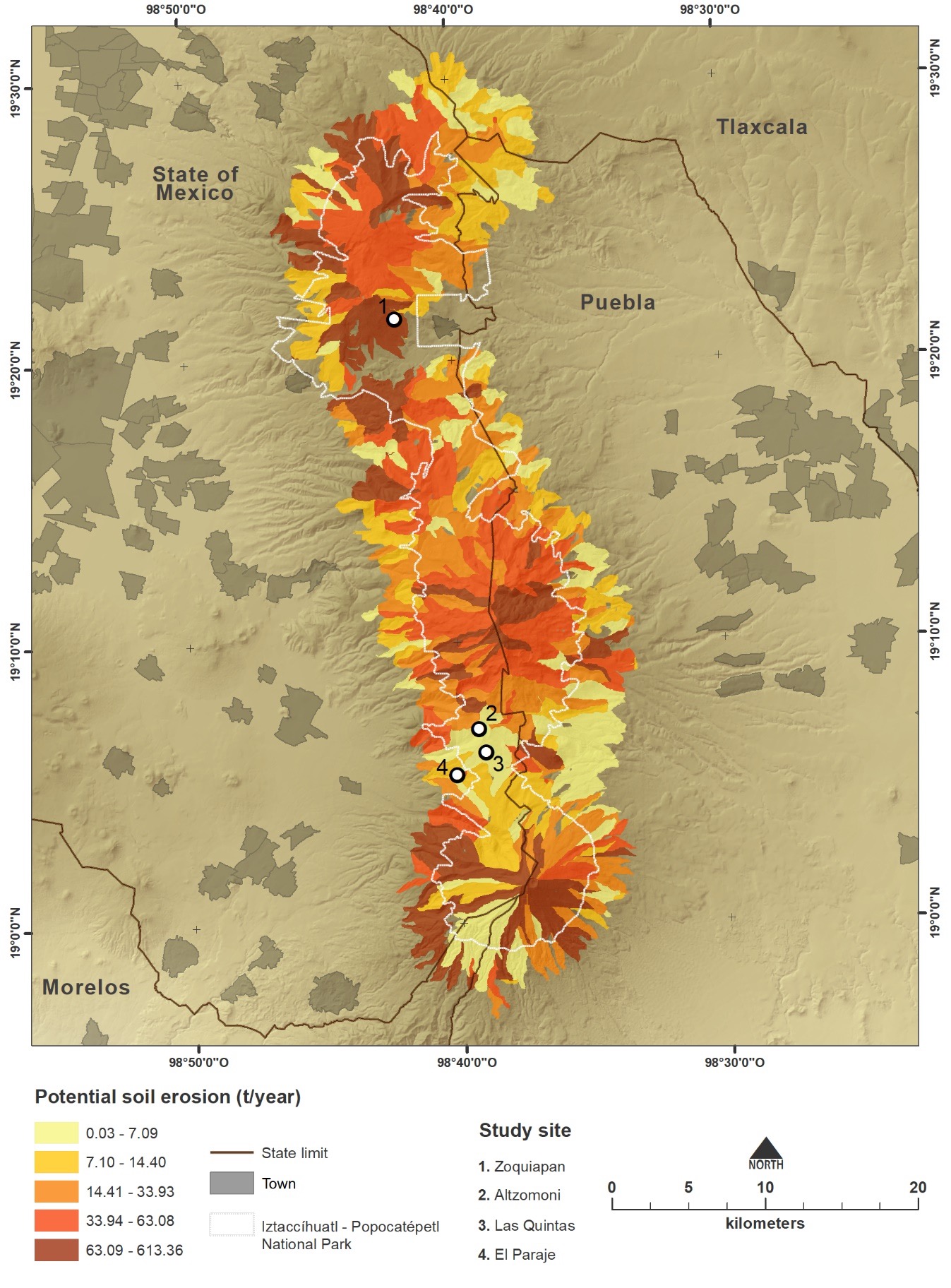
The results of the erosion model (Figure 3) reveal that the average potential erosion was 42.5 t/ha in the Iztaccíhuatl-Popocatépetl NP. However, because of the area’s topographical, soil, climatic, and land-use diversity, potential erosion levels varied widely from one subbasin to another, from 0.02 t/ha to 613 t/ha. It thus appears that the ditches were constructed indiscriminately in subbasins with minimum or maximum potential erosion.
There was a larger number of ditches constructed in grassland areas (528) than in forest areas (217) (Galván-Díaz, 2016; Ramírez-Santiago, 2016). The soil characteristics and number of ditches at each site explain why the removed, extracted, and mobilized soil amounts to 197 t/ha-421 t/ha in grasslands and 85 t/ha-133 t/ha in forests. The amount of soil extracted and disaggregated by the ditches is thus larger in grasslands than in forests.
The excavation of ditches leads to the destruction of soil aggregates which, by becoming exposed on the ridges, are more vulnerable to erosion. Except for Zoquiapan, the construction of ditches always resulted in a higher potential erosion than the modeled one, reaching values up to 60 times higher (Table 4).
Areas of bare soil, typical of ridges, tend to export water and sediment (Cerdà, 1997; Pueyo et al., 2008). Also, areas with patchy vegetation are at increased risk of developing gullies and other erosion structures, resulting in irreversible soil degradation (Cammeraat & Imeson, 1999). Such forms of erosion caused by the construction of ditches are already visible in the Iztaccíhuatl-Popocatépetl NP (Figure 7).
Source: Autor’s own elaboration.
Figure 6 Potential soil erosion in the Iztaccíhuatl-Popocatépetl National Park, Mexico.

Soil organic carbon sequestration
Excavating the top 40 cm of soil to construct ditches removes large quantities of soil, which become exposed to the erosive effect of rainfall. Increased soil disturbance by farming -or in this case excavations- is the main factor for the mineralization of organic matter (Bedard-Haughn et al., 2006; Robert, 2001).
In the Iztaccíhuatl-Popocatépetl NP, the excavation of ditches was found to have exposed 3.7 t-12.5 t and 1.92 t-3.3 t of organic carbon/ha in grasslands and forests, respectively (Galván-Díaz, 2016; Ramírez-Santiago, 2016). Considering the area of grasslands and forests affected by ditch construction, the amount of exposed organic carbon was estimated at 8944.3 t-30 217.1 t and 2631 t-4522.3 t in grasslands and forests, respectively, for a total of 11 575.3 t to 34 739.4 t.
This loss of soil organic carbon is more severe in that it is the main factor in maintaining basic soil functions (Janzen, 2006), especially since sources of organic carbon are by definition very limited on degraded (e.g., grazed, deforested) lands, with little vegetation left (Balbontín et al., 2009). The loss of several tons of organic carbon per hectare will thus undoubtedly hamper the recovery of these soils’ functions. For this to happen, all soil conservation practices should seek to recover, maintain and/or increase the amount of organic matter in the soil (Chabbi & Rumpel, 2009; Delgado et al., 2013; Jandl et al., 2007), which is not possible with ditches.
In summary, we can state that the construction of ditches leads to negative effects on ecosystem services related to water regulation, carbon sequestration, and regulation of soil erosion, as shown in Table 5.
Table 5 Negative impacts of constructed ditches on ecosystem services provided by the Iztaccíhuatl-Popocatépetl National Park, Mexico (estimated for the total area with ditches).
| Vegetation Type |
Loss of Natural Infiltration (m2/ha) |
Potential Soil Erosion (t/ha) |
Exposed Organic Carbon (t) |
| Grassland | 4984-6363 | 197-421 | 8944.3-30 217 |
| Forest | 1405-2016 | 85-133 | 2631-4522 |
Source: Autor’s own elaboration.
Discussion
For 11 years, government entities, companies, and non-governmental organizations (NGO) implemented the Rainwater Harvesting project to increase aquifer recharge in the Iztaccíhuatl-Popocatépetl NP. At the end of this period, about 10% of the Park’s area was modified by the construction of ditches. This program was carried out neither with a prior assessment nor with a final evaluation at the end of the program.
After assessing the impacts of such a project, our analysis concluded that far from increasing water infiltration, the program induced the opposite result. Moreover, not only water infiltration was lost but also soil erosion and carbon liberation occurred. This is a fine example of what the policy literature refers to as a public policy bearing “perverse effects'' (Vedung, 1994). Thus, there are two clear policy lessons to be learned: a) It is not “conventional wisdom” but rather sound scientific advice that should be at the design stage of any conservation project, and b) effective conservation is enhanced by implementing adaptative management measures, since this approach enables the timely correction of possible deviations from original goals, increasing the possibility to avoid unintended results and thus achieving greater effectiveness.
In this study, two of the most common methods for modeling ES were used in an integrated manner: one based on well-known causal relationships established between environmental variables from secondary data sources, mainly geographical databases, and one based on the extrapolation of primary data collected in the field (Martínez-Harms & Balvanera, 2012). The availability of both secondary and primary data relating to the Iztaccíhuatl-Popocatépetl NP allowed the spatial heterogeneity of constructed ditches to be better captured. While GIS can be a powerful tool for mapping and assessing ES, it may be most effective when implemented as part of a methodological framework that integrates technical information at multi-scales with variables and field measurements for estimating ES values with value-driven decisions and accounts for uncertainty (Nemec & Raudsepp-Hearne, 2013; Martínez-Harms et al., 2016; Uriarte et al., 2011).
Modeling ES linked to water regulation (infiltration) and potential erosion made the environmental heterogeneity of the Iztaccíhuatl Popocatépetl NP visible at the regional level. In this region, ditches were constructed on soils types andosol and luvisol, whose infiltration and potential erosion rates vary from low to very high. This means that the ditches were not constructed keeping in mind particular soil conditions, the need to control erosion, or the improvement of water infiltration. As has already been suggested, a poor initial design and lack of clarity regarding goals are two of the three main problems hindering monitoring effectiveness.
According to Lindenmayer & Likens (2009), the solution lies in what they term “adaptive monitoring”, that is, a monitoring linked to the protection of ES. Here, constructing ditches was shown to have negative impacts on the three ES studied.
With respect to soil erosion, defined as the total amount of soil material dislocated and removed some distance (Trimble, 1975), potential erosion following the construction of ditches was almost always found to be higher -up to 60 times- than modeled potential erosion. These results coincide with those found by Muñoz-Salinas & Castillo (2018), who through methods of fallout 137Cs and optically stimulated luminescence (OSL) strongly suggest that ditches, trenches, and afforestation dramatically modify the natural mechanisms of sediment transfer and favor soil erosion. They conclude that these are not effective conservation practices because they are promoting soil erosion instead of reducing it.
Furthermore, soil erosion leads to the breakdown of structural aggregates, increasing mineralization and the emission of CO2, whereas the prevalence of anaerobic conditions during sedimentation results in increased methanogenesis and denitrification, leading to the emission of CH4 and NO2, both of which are gasses having greater global warming potential than CO2 (García-Ruiz et al., 2017). Large quantities of carbon can be liberated to the atmosphere when soil is detached and transported, although “there is no scientific consensus on the global net balance effect of erosion on the carbon cycle” (Naidoo et al., 2008).
Regarding the ecosystems studied, the impact of ditches differed between grasslands and forests, being the loss of ES always greater in grasslands than in forests. The management of protected areas is “likely to become more complex because of the range of new factors to be considered” (Hagerman et al., 2010) and the urgent need for action despite the lack of information available. Thus, effective conservation requires adaptative management, i.e., “to constantly monitor, reassess, respond to change and alter management [...], and be explicit, transparent and scientifically rigorous in treating risk and uncertainty if we are to begin to deal with climate change impacts” (Tanner-McAllister et al., 2017).
In the context of adaptative management, it is necessary to strengthen the relationship between practitioners and researchers, with the challenge of developing “conservation practitioners with adaptative-management knowledge and skills” (Salafsky et al., 2002). The creation of a network of practitioners and researchers was precisely the objective of the Forum on Adaptative Management in Protected Natural Areas of the Central and Trans-Mexican Volcanic Belt Regions, which took place in 2016. This forum provided the opportunity to discuss the impacts of ditches, soil conservation objectives and the best way to meet them. Such initiatives should be further strengthened and extended to other protected areas, with a view to monitor and assess management practices to propose better ones aiming to co-design a transdisciplinary management plan to promote the interaction between community, researchers, and governance.
Conclusions
The construction of ditches has many negative environmental impacts. We assess the impact of constructing ditches on three ecosystem services provided by the Iztaccíhuatl-Popocatépetl NP at the regional scale, using both secondary data analyzed in the geographic information systems environment and primary data collected in the field. Our results confirm that ditch construction has many spatially differentiated negative impacts on the landscape, such as alteration of the natural conditions that allow infiltration, increased potential erosion, and mineralization of organic carbon on the ridges. These results confirm the need to evaluate and monitor the impacts of government programs aiming to propose best practices with the general objective of implementing co-constructed management plans in order to guarantee a better future for protected areas and the ecosystem services they provide.
Clonflicts of interest
None of the authors has any conflict of interests.

