


 nueva página del texto (beta)
 Inglés (pdf)
 Artículo en XML
 Referencias del artículo
 Enviar artículo por email
 Citado por SciELO
  Similares en
SciELO
Similares en
SciELO 
 Permalink
Introduction
Real-estate industry always surpasses any possibilities of conducting urbanization under a well-planned system according to the directions of urban planning, and this is even more evident in the boundaries of municipalities. The interventions intended to improve the boundary of urban system not always bring improved occupation conditions, that is, the experience of living in the periurbanization sometimes is usually hostile (González & Asprilla, 2016; Zulaica & Celemín, 2008).
Consequently, it is possible to talk about the right to occupy the habitable space or the right to have a house as a universal priority, which is linked to the liabilities of a State. However, private interests such as those of the real-estate sector or the financial sector, as well as the power of the control or monitoring organizations, result in a combination of isomorphism in operative procedures, and housing becomes a commodity that depends on a cost-benefit assessment.
In the Mexican case, housing access has been studied from two different upturn views, allowing to discern characteristics and nature in order to identify the development of historical background. On the one hand, there is a vision that belongs to the State as a nationalist defender and protector of social positions in favour of the population’s welfare (Catalán, 1993). On the other hand, there is another trend which upholds that housing policies must be considered and administrated as a governmental measure of control in favour of social sectors and less favoured classes (Pradilla, 1982).
In accordance to the above, between the decades 1940s and 1980s of the last century, cities like Mexico City, Guadalajara and Monterrey experienced major demographic developments (Alba, 1979; Arroyo, Winnie & Velázquez, 1986; Vázquez, 1989); Mexico City’s population, for instance, grew up an average of 6.5%, reaching a population of 2.9 million people (Garza, 2003). This trend put on the State a higher pressure to provide urban housing, so it was necessary to implement the first housing programs in which institutions in charge had to provide around 53 622 social houses for rent (García, 2010). This led to the real-estate sector to become the main actor in the creation and funding of housing, which, in turn, led to the Infonavit (an organization for the promotion of housing) to stop acting as the Housing Fund and performed as a source of resources and funding for the building industry.
During the first decade of the XXI century, the World Bank prescribed that housing funding should expand funding to include the informal sector and the population with limited resources (Monkkonen, 2011). These directions were adopted by the Mexican State, which played a key role in the privatization of housing funding and, thus, benefiting the real-estate sector more than the targeted population; even real-estate or mortgage entities persuaded people to acquire a first or a second mortgage no matter their borrowing capacity; notwithstanding, large companies such as Corporacion GEO S.A. de C.V., Consorcio ARA, Desarrolladora Hogares Méxicanos S.A. de C.V.(HOMEX) and others suffered considerable capital losses with the financial collapse of 2009, triggered by the financial crisis in the United States which stroke Mexican real estate companies by the network effect given by the interconnection of global markets (Sassen, 2009).
In 2013, in the Official Newspaper of the Federation, it was mentioned that the second decade of the XXI century has been characterized by a change in public policies, privileging compact residential housing. However, the flexibility in the application of housing policies has favoured property speculation by increasing the cost of land, and favouring peri-urban building; and this has occurred even though when urban policies tend to adopt a focus in the “containment of uncontrolled growth of boundary urban areas, the consolidation and the compacting of the cities, and the diversification of hosing alternatives, and the attention of the rural housing” (Diario Oficial de la Federación[DOF], 2018).
Only keeping in mind the situation in Mexico, and from a socio-economic perspective, it is possible to identify some spontaneous residential settlements in the peri-urbanization, some others correspond to social constructions, and a number of others can be considered suburban (Signorelli, 1999). From the first two groups, it can be distinguished that there are three types of housing:
A group of constructions that come from the modality of subsidized housing. These houses are occupied by low income people who have access to a type of credit. These settlements were called by Giglia (2012) as a type of rationalist housing. The design of these houses has very little creativity and is a model which is constantly repeated, the design of these houses is a kind of copy-paste model providing access to some of the most basic utilities for the residents.
On the other hand, it is possible to find in these areas a type of construction known as self-construction, these houses are built according to the economic possibilities of the dwellers, and the conditioning of equipment and infrastructure of these constructions always occurs after the purchasing of the corresponding portions of land. These are houses built by their owners with their own resources in a progressive way (Rodríguez, 1994); in other words, this is what Giglia (2012) calls progressive housing.
At the same time, Barranco & González (2016) found in their empiric work a combination of both classifications; this is what they call progressive and rational occupation. The authors consider this system can be called rationalist (or rational), these areas are always offered through a public policy in order to have access to a private property provided with basic utilities. These units can be inhabited as neighbourhoods although they can also be progressive; in fact, dwellers usually equip their houses with something particular through progressive renovations and/or extensions by gradual improvements according to the family’s needs and budget possibilities.
As a matter of fact, housing in these areas is linked to the conditions of the construction and the possibility to have access to the utilities required by the dwellers. According to Oriolani (2016), housing is understood as a set of social and economic factors within environmental, special and physical conditions affecting the quality of life of residents; therefore, urban housing considers two main components: habitat and use. The first definition implies the space system and the resources chosen by a group of people for living. It responds to the needs to carry out individual and collective projects. In this way, the habitat is circumscribed to a specific geographical place, and it satisfies specific and general needs. On the other hand, use can vary in time and space and it determines occupancy of soil and different ways to interact with the environment. Habitat, therefore, implies several social and individual activities (contracts and codes) that allow human beings to interact in an organized society on the occupied portions of soil (Zulaica & Celemín, 2008).
When analysing the so-called progressive and rational use of soil, it can be considered the concept of use as a component that sets the resources and utilities and deals with the environmental and social problems in peripheral areas where the constant incorporation of land, not destined for urban purposes, invade the productive land (agricultural purposes), change ecosystems and, consequently, change the conditions of habitability of the local population. In many cases, it can be considered that these places are occupied by low-income people who settle their dwellings in unsafe soils and susceptible to natural disasters (Hernández & Vieyra, 2010).
After the metropolitan area, in the Mexican Valley, the second big city with higher rates of growth is Guadalajara (AMG). In these areas of periurbanization, the location of industries has become a big factor of attraction for a large number of the population and, in turn, there have been corresponding consequences in the environmental, social and financial fields, which indeed affect the day to day process of soil use. Additionally, the growing demand of soil for housing purposes has led to the eradication, substitution and extrapolation of original activities. This work, therefore, is intended to identify the hostile forces (entropic forces) AMG peri-urban dwellers experience, especially because it is supposed that these forces of entropic character produce entropy in the process of occupying the periurbanization. For the purpose of this study, the locality known as Galaxia-Bonito-Jalisco was chosen (GBJ), this locality is part of El Salto municipality, which is one of the nine municipalities composing Guadalajara; this location was chosen because at the inspection in situ, it was confirmed that the place meets the required conditions of peri-urban growth.
In this context, the entropy has been conceived as a force of disorder of anthropic origin, that unsettle the homeostasis of the system (González, 2017). This has led to strategically resume the conceptual precepts of the theory of the systems, where the boundary, or peri-urban area, would be pressed by the flux of the matter and energy (environment-system and system environment) and dependable of the interactions of the metropolitan outputs and the extra-urban inputs.
Materials and Methods
For the identification of this set of hostile forces, the compilation of an index of occupancy was necessary, composed by a variety of related conditions in connection with the periurban use (GBJ) by the analysis of the main components that synchronise the access to resources and urban services and select the variables of the population census and housing 2010, which shows the situation in which local inhabitants are living.
The indicators selected in the occupancy index (OI) include three dimensions, each having three indicators for each dimension: health, education and occupancy. These dimensions are related with the problems experienced locally, in terms of social and urban development. The indicators that measure sanitation quality and housing quality are directly related to the environmental hardships experienced in the peri-urban area, such as: a) coverage of some utilities and b) the quality of life within the house.
On the other hand, the indicator of the level of schooling allows to measure the vulnerability of the social groups, by the moment the dwellers enter in the labour market (Table 1).
Table 1 Dimensions, indicators, and variables for analysis
| Dimension | Indicator | Analisys Variables |
|---|---|---|
| Health | Sanitary Quality | 1. Population with no
access to health services. 2. Dwellers with access to tap water in residential areas. 3. Dwellers that have toilet services and access to water and drainage in their houses. |
| Schooling | Level of Schooling | 1. Average level of
schooling. 2. Dwellers aged 15 or more with basic incomplete education. 3. Dwellers with employment aged 12 or more with at least one approved grade in primary school. |
| Habitability | Description | 1. Number
of inhabited houses. 2. Dwellers in inhabited houses. 3. Number of inhabited houses with two or more bedrooms. 4. Number of inhabited houses provided with electricity, tap water and access to the drainage network. |
Source: Author’s own elaboration. Compilation based on the data of the Population and Housing Census 2010 (INEGI, 2010).
The construction of the OI used the statistics application SPSS helps to analyse the selected variables in order to provide a series of procedures and models of multivariate nature that reduce dimension and allows a better interpretation of the available data. Thus, after the revision of the components and the factorial analysis, it is possible to find new variables called main components and factors which, in a reduced number (reduction of dimension), simplify the information contained in the variables; and when carrying out the descriptive analysis, the factorial analysis remains the same by the extraction of the main components (Véliz, 2017). Once these variables were regularized, and after the descriptive analysis, the factorial analysis goes on by the extraction of the main components. Additionally, an execution test was obtained by applying the Kaiser-Mayer-Olkin (KMO), and another one was obtained for each dimension by using the Barlett sphericity test.
Accordig to Véliz (2017), the KMO index measures the partial correlation of the two variables, as follows:
If KMO < 0.5, the application of the analysis is inappropriate.
If 0.5 ≤ KMO < 0.7, the application is partially accepted.
If KMO ≥ 0.7, the convenience of the application is accepted.
In this framework, Bartlett’s test evaluates whether the matrix of correlations is significantly different from the identity matrix. Therefore, if the determiner of the correlations or covariance matrix is near to 0, the analysis is accepted (Table 2).
Table 2 Test of the analysis
| KMO and Bartlett Test | Health | Schooling | Habitability | IH |
|---|---|---|---|---|
| Kaiser-Meyer-Olkin measure of sampling | 0.715 | 0.507 | 0.827 | 0.911 |
| Bartlett sphericity test (Chi Sq aprox.) | 1503.711 | 293.479 | 1815.707 | 5651.821 |
| Gl | 3 | 3 | 6 | 45 |
| Sig. | 0.000 | 0.000 | 0.000 | 0.000 |
Source: Author’s own elaboration. Compilation based on the data of the Population and Housing Census 2010 (INEGI, 2010).
Finally, once the IH is calculated, the georeferencing of the result in the ArcMap is carried out. The scale were the blocks of the GBJ locality, and the result was two maps showing which blocks have the highest rates of habitability as well as the level of induction.
Results
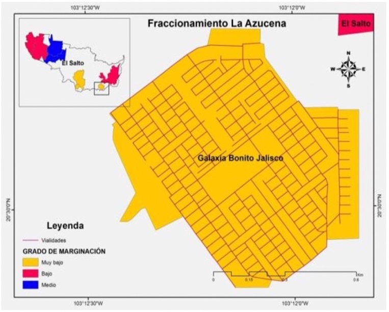
The GBJ urban locality known as La Azucena is located towards the Southeast of the AMG, and it is three kilometres away from El Salto, municipal capital (Figure 1). It is possible to access this locality by El Salto of Juanacatlan and Los Sabinos motorway. This locality is made of five basic geo-statistical areas (AGEB). It is surrounded by properties of the communal type and is adjacent with Las Pintas canal, which is the mouth of the Santiago River. Its population is 9082 inhabitants; 4624 men and 4443 women. The economically active population is 39.06%, and the population not economically active represents a 26.28%. The educational conditions of the population is 78.24%, with an average degree of primary school that is between 8 and 9 years of age, although 25.51% does not have any type of schooling (Instituto Nacional Estadística y Geografía [INEGI], 2010). The typical houses found in this place belong to the category of social scope and are equipped with basic utilities. The level of marginality in this area is considered as low, according to the Consejo Nacional de Población (Conapo, 2010). This means that there are not poverty conditions of social vulnerability for its residents (Figure 2).

Source: Author’s own elaboration. Compilation based on the data from Science 2010 (INEGI, 2010).
Figure 1 Studied Area; Galaxia-Bonito-Jalisco
Source: Author’s own elaboration. Compilation based on the data from Science 2010 (INEGI, 2010).
Figure 2 Conditions of social development according to their degree of marginalization
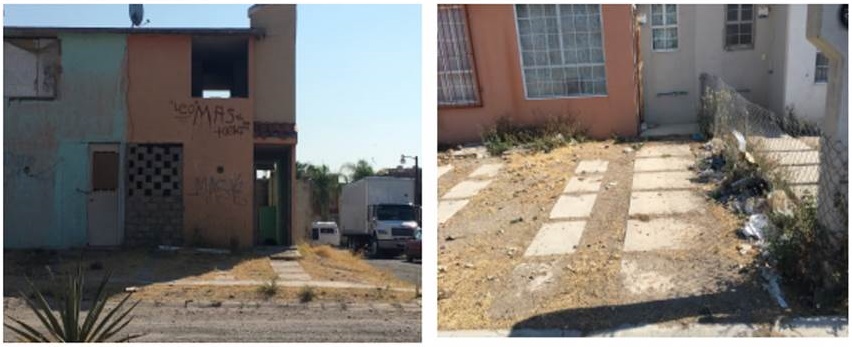
In the fractioning, there is a total of 4339 houses of one or two levels; from this number, 2404 houses are inhabited (55.40%) and 1197 have one bedroom and 863 two bedrooms (INEGI, 2010). Most of the houses have been modified from the original model (progressive and rational occupation); nonetheless, there are troubles in terms of roadways connectivity, there are some paths that lead to nowhere, all this causing access difficulties. In terms of urban conditions, it can be seen some care neglected areas such as roads, tall grass, and there is a lot of trash on the streets, waste lands and some other risky areas. According to available information, the area with more population corresponds to the main roadways, in contrast with those located near Las Pintas canal, which are less inhabited areas (Figures 3 and 4).
Source: Author’s own elaboration. Fieldwork research, december 2016.
Figures 3 and 4 Entropies in the rationalist-progressive occupancy in La Azucena
According the results given by the OI, there are two main components in which the most representative variables of the occupancy conditions are those known as the characteristics and the prize of the house. These variables were grouped into two main groups. In the component 1, the variables included are: population with incomplete education, dwellers in a house with tap water, houses provided with a toilet, inhabited houses, and more complete houses provided with basic utilities as tap water, electricity and drainage system. These houses are strongly related with the IH. In the component 2, there are not any tangible association of variables but something to highlight is the level of schooling, which is variable and in itself does not provide any level of significance on component 1; however, it contributes to the general model (Table 3).
Table 3 Components Matrix
| Variables | Component | ||
|---|---|---|---|
| 1 | 2 | ||
| Population with incomplete basic education | 0.956 | -0.0166 | |
| Population with some level of primary education | 0.879 | -0.236 | |
| Population with no access to health care services | 0.909 | -0.002 | |
| House dwellers with tap water | 0.992 | 0.068 | |
| Houses with a toilet | 0.993 | 0.066 | |
| Inhabited houses | 0.989 | 0.062 | |
| Dwellers in ihabited houses | 0.992 | 0.068 | |
| Inhabited houses with two or more bedrooms | 0.811 | 0.345 | |
| Houses provided with water, electricity and drainage | 0.989 | 0.065 | |
| Average educational background | -0.001 | 0.961 | |
Source: Author’s own elaboration. Compilation based on the data of the Population and Housing Census 2010 (INEGI, 2010).
The model of the main components shows two components in the studied variables:
In the first component, the variables with a higher representation are those higher in values. The highest value is 0.993, followed by the next figures: 0.992, 0.989 and 0.956. In these values group, there are six variables describing inhabited houses provided with basic utilities with a population with incomplete education. In other words, the type of housing in the GBJ is aimed to a low-class population.
In the second component, the most outstanding value in the model is the level of education which is represented by the variable according the average level of schooling. This confirms that most of the members in the population in this locality has an incomplete level of education.
On the other hand, the locality is attached to harsh urban infrastructure conditions, complex, and almost impossible to live, where access to basic utilities such as urban equipment, education, health care, trade, cultural activities or entertainment is critical (Table 4).
Table 4 Utilities in the localilty of Galaxia Bonito-Jalisco
| Type of facility | Number | Sector |
|---|---|---|
| Education | 2 pre-primary education schools | Public |
| 2 schools combining different grades of education | Public | |
| 1 secondary school | Público | |
| 1 school combining different grades of education | Private | |
| Health | 1 office of specialized medicine | Private |
| Commerce | 148 retail shops,
bakeries, tortilla shops, markets, stationeries, coffee shops,
internet cafés, hardware shops, and clothing and shoe shops. |
Private |
| Entertainment | 2 fitness centers | Private |
Source: Author’s own elaboration. Compilation based on the data provided by Directorio Estadístico Nacional de Unidades Económicas DENUE, 2014.
On Table 4, it can be observed the equipment assigned to preschool educational centers, as well as primary and secondary school. Nonetheless, there is not a high school for the inhabitants to continue with their secondary studies. However, in the private field, there is a school offering educational programs for different levels of teaching. On the other hand, there are no records of public health care installations in this area, the only exception is a specialized medicine office and the Desarrollo Integral de la Familia center (DIF), which provides services as a community center. Finally, this area is nurtured by formal and informal trade, the research in situ identified formal and informal kinds of business offices and stores.
The locality is subject to hostile and uninhabitable urban infrastructure conditions where access to basic services such as urban facilities, education, health, commerce, culture or recreation are not the best. These conditions represent the anthropic forces associated with social vulnerability, and manifest in entropy or disorder of the colony.
Discussion
According to Cerda & Marmolejo (2010), García (2000), Garrocho & Campos (2006) and Ramírez (2006), access can be an easy to understand concept; however, when it is required, to define and measure this concept is not so easy, because it is linked to a number of other fields like geography, economy, physics and urban planning. Access becomes a concept and a basic element of focused planning, and it might be defined as the distance that separates people from the place where they are and the place they need to relate for any kind of reason (Ramírez, 2006). At the same time, access is considered as the element that articulates transport within urban structures; nevertheless, this concept has been changing within the time, both in the conceptual and in the methodological aspects.
The emerging locality of GBJ was conceived as rationalist occupancy (Giglia, 2012), since it was built in a fractioned way according to the needs of the people, based on their social conditions. However, the conditions of the peri-urban areas are not always the best. In La Azucena, for instance, real-estate investors have generated complex conditions for occupancy to the extent that some dwellers consider there is not enough space in the original house, consequently, they tend to appeal (within their possibilities) to the progressive style of occupancy, which configures the aforementioned progressive rationalist occupancy.
In this type of dwelling it can be identified entropic components associated with the provision of hydro-sanitary, road, organizational, and security infrastructures. There is evidence of water scarcity for human consumption, recurring floods, the flooding of the stream Las Pintas, and the weakness of the drain infrastructure. In the organizational field, it is evident the lack of a social structure committed with the local environment; these hostile forces contribute to complex scenarios are considered in Table 5.
Table 5 Entropic Forces
| Dimension | Indicator | Entropic Forces |
|---|---|---|
| Health | Sanitary quality | Health public policies focused in attending urban needs. Frequent shortage of medicine and slow processes and bureaucracy that encourage private sectors intervention. |
| Education | Level of schooling | Lack of community integration, lack of teams or neighbourhood organization. |
| Occupancy | Housing type | Housing construction at minimum costs and maximum profit. Housing is sold as a product without overcrowding considerations due to the fact of dimensioning and complementary infrastructure conditions (hydro-sanitary installations, roads, entertainment, etc.) |
Source: Research Project, 2016. Author’s own elaboration.
Conclusions
Currently the characteristic of the periurban boundary increasingly threatens the homeostatic working of the constituent components, and this occurs due to the fact that the growth in the population is rapidly increasing along with its needs in terms of occupancy, mobility, water consumption, energy sources, food sources, etc. Indeed there are anthropic actions pretending to counteract their own behaviour, known as negenthropic (González, 2017), for example, water treatment, recycling, the application of ecotechnies, newer regulatory directions for the use of space, or the culture of scarcity which tends to decrease the entropy in the system.
In this context, the boundary (peri-urban area) which sets the rural-urban limit is an area that is located within the limits of the system where the process of urbanization occurs. The social panorama of these population nodes in the locality Bonito-Jalisco, which is rationalist and progressive, identifies problems in the process of using the soil. Even though the index of marginalization shows social stability, the inspection in situ points to conditions of poverty and serious environmental problems, especially because through the OI it is possible to show that the type of housing given in the locality of GBJ is used by a popular portion of the population of low income, where the majority of the population only has an incomplete type of schooling. These hostile conditions worsen when the public policy of the State, in matters such as health care, focusses on the urban system. This entails medicine shortage and benefits the intervention of the private sector. In addition, the lack of community integration and collaborative work and the instrumentalization of mechanisms of neighbourhood organization contribute to hostile situations in the process of inhabiting the periurbanization.

