


Servicios Personalizados
Revista
Articulo
 texto en
  Inglés (pdf)
 Artículo en XML
 Referencias del artículo
 Enviar artículo por email
Indicadores
-
 Citado por SciELO
 -
 Accesos
Links relacionados
-
 Similares en
SciELO
Similares en
SciELO
Compartir

 Permalink
Investigaciones geográficas
versión On-line ISSN 2448-7279versión impresa ISSN 0188-4611
Invest. Geog no.110 Ciudad de México abr. 2023 Epub 26-Jun-2023
https://doi.org/10.14350/rig.60692
Articles
The Volcanoes of Alexander von Humboldt and Johann Moritz Rugendas. The Humboldtian Landscape Complex

* Instituto de Investigaciones Estéticas, Universidad Nacional Autónoma de México, UNAM. Ciudad Universitaria, Circuito Mario de La Cueva s/n, Coyoacán, 04510, Ciudad de México, México. Email: omarolivaressandoval@comunidad.unam.mx
Landscape history and theory have included thoughts on their parallel development as analytical concepts and as a visual and pictorial genre. In this context, the work of the polymath Alexander von Humboldt is a reference since he considered that landscape aesthetics and epistemology were central elements of his notion of "physiognomy". Through the cases of Humboldt and the Bavarian painter Johann Moritz Rugendas, including the drawings of the latter for Christian Sartorius's book, this article analyzed the development of landscape aesthetics as part of the interdisciplinary framework of Geography and Geology, and their networks of agents, which were interested in the interdependence of scientific knowledge and industrial development. The selected approach explores the visual construction of landscape and the scientific and social trajectories involved in its production. The case of the Jorullo volcano illustrates how landscape aesthetics was used to generalize the geological knowledge, along with a geographic approach for the colonization of Mexico. Likewise, the case of the Colima volcano serves to analyze the simultaneous production of landscape, geological, geographic, and cartographic observations, as well as viewpoints on industrial modernization. This constellation is named the “Humboldtian landscape complex”.
Keywords: Landscape; Alexander von Humboldt; Johann Moritz Rugendas; physiognomy
La historia y teoría del paisaje han incluido reflexiones sobre su desarrollo paralelo como concepto analítico y como género visual y pictórico. En tal contexto, el trabajo del polímata Alexander von Humboldt es un referente, al haber considerado a la estética y la epistemología del paisaje como elementos sustanciales de su noción de “fisionomía”. A través de los casos de Humboldt, del pintor bávaro Johann Moritz Rugendas y de sus imágenes para el libro de Christian Sartorius, este artículo propone un análisis del desarrollo del paisaje en el marco interdisciplinario de la geografía y la geología y sus redes de agentes interesados en la mutua dependencia de conocimientos científicos y el desarrollo industrial. El enfoque adoptado explora el modo de construcción visual del paisaje y las trayectorias científicas y sociales involucradas en su producción. A través del caso del volcán Jorullo, se presenta la forma en que la estética del paisaje fue usada para generalizar conocimientos geológicos y, en paralelo, una geografía para la colonización del país. Asimismo, a partir del caso del volcán de Colima, se analiza la producción imbricada de paisaje, observaciones geológicas, geográficas y cartográficas, al igual que puntos de vista sobre la modernización industrial. A esta constelación de relaciones se denomina: “complejo humboldtiano del paisaje”.
Palabras clave: paisaje; Alexander von Humboldt; Johann Moritz Rugendas; fisionomía
INTRODUCTION
We owe a large part of the meaning of the word landscape to Alexander von Humboldt, a concept understood as a physical reality expressing the inner order of nature and as a visual expression of this same order and unity through depictions and graphics resulting from the aesthetic abilities of the subject. According to Chunglin Kwa (2005), Humboldt was the main creator of the “natural landscape” concept, that is, conceiving the landscape, until then used to refer to the artistic genre as a natural unity. The role that the "physiognomy" concept played in this transformation has been discussed (Havenon and Lubowski, 2014; Lubowski, 2009; Dettelbach, 2005). Without a comprehensive theoretical analysis of physiognomy (physionomie), Humboldt adopted it as a central concept, referring to the one “who comprehends nature at a single glance, and knows how to abstract from single phenomena":
As we recognize in distinct organic beings a determinate physiognomy, and as descriptive botany and zoology, in the restricted sense of the terms, consist in detailed analysis of animal and vegetable forms, so each region of the earth has a natural physiognomy peculiar to itself. (Humboldt, 1849, 2, p. 13).
It has been pointed out that the closest origin of the concept corresponds to the method that Pastor John Caspar Lavater proposed to infer the moral nature of a person by drawing the silhouette of his/her face (Lubowski, 2014: 49; Kwa 2005, p. 153; Dettelbach, 2005, p. 492). Similarly, Humboldt proposed physiognomy as an operation stemming from the visible to gain access to the invisible, that is, the “underlying essence” of the natural order. (Dettelbach, 2005, p. 494; Garrido, 2018, p. 283). Hence, he considered in his Cosmos that “to apprehend these characteristics, and to reproduce them visibly, is the province of landscape painting” (Humboldt, 1849, 2, p. 456). Thus, Kwa states: “Humboldt projected painted landscapes on nature [… ]" (Kwa, 2005, p. 153). In his writings, Humboldt frequently used the terms physiognomy, landscape, zone, region, district, or plant types interchangeably; these indicate relationships between particular elements (plant species, minerals, monuments) and "general descriptions" (the fern regions, the tropics, the North). (Humboldt, 1999, p. 255). Given the implication of physiognomy in a process that interrelates view, abstraction, synthesis, and representation, it is necessary to approach its production practices.
The more succinct history of practices related to this geographic landscape matrix opens up multiple avenues that can still be explored. Previous works have sought to visualize Humboldt and Rugendas in their practical worlds (Podgorny and Schäffner, 2000). Historian Patrick Anthony observes the closeness of Humboldt’s innovations (such as his geography of plants) to the practices of Prussian mining schools and their collaborative networks. Anthony coined the term "underground Enlightenment of central European mining", which seeks to characterize aspects bypassed by the "Humboldtian science” concept (Dettelbach, 2000), by differentiating Humboldt’s practices from an abstract European "Enlightenment". (Anthony, 2018, p. 31). Despite this interpretative shift, it can be pointed out that Humboldt's updating of ancient knowledge as physiognomy complicates the notion of enlightenment in the broadest sense of "scientific" practices (Hartley, 2001; Stemmler, 1993). On the other hand, it is presumed that "enlightenment" was not only European but also American and that Humboldt was "enlightened" by his contacts with American savants and his dense network of collaborators. (Achim and Goldin, 2023, p. 235; Nieto, 2018, pp. 203-247). By presenting two cases on the physiognomies of the Jorullo and Colima volcanoes, the aim is to analyze some processes that relate landscape and geographic, geological, and volcanological knowledge in the first half of the nineteenth century.
It is worth mentioning that mountains and volcanoes have been considered central objects of Humboldt’s disciplinary project (Farinelli, 2021, p. 60; Debarbieux, 2012).
Humboldtian reflection is part of the extensive questioning of the origin of mountain ranges and the role of volcanic activity in the first decades of the 19th century. The mountain, which is also the scenario of the Humboldtian “geography of plants”, as Bernard Debarbieux (2012, p. 21) states, “goes hand in hand with knowledge of the world” and mankind for Humboldt. Although the volcano is a key element in the Humboldtian discourse, it is not a stable object in it. Moreover, when linked to aesthetics as the sublime, it is frequently displayed as the very limit of the utterable (Heringman, 2003, p. 104), which makes it an ideal object for an approximation, such as that of physiognomy, which seeks to communicate the observable with a hidden reality.1
THE JORULLO LANDSCAPE AND GEOLOGY
On September 19, 1803, five men: Humboldt, Aime "Bonpland", Ramon Espelde (from Nueva Vizcaya), and two "Natives" whose names were not transcribed, climbed the Jorullo volcano (near today's Patzcuaro, Michoacán) and recorded the height, temperature, acidity, and composition of rocks and air. Strapped on a rope, Humboldt went down to the bottom of the crater to obtain measurements: height, 575 "toises"; temperature, 34 degrees reaumur; and one in particular, "the most interesting one and for which I wanted to descend into the crater": the composition of the air emanated from the volcano. The subsequent reading yielded an abundance of carbonic acid (carbon dioxide) that was not found, for example, in Pico del Teide, in the Canary Islands.
After the visit, after recording measurements and collecting gases and rocks, the Jorullo volcano appeared as an object refined in the discourse and visible in the famous Vues de cordillères et monumens des peuples indigènes de l’Amerique (Views of the Cordilleras and Monuments of the Indigenous Peoples of the Americas) (1810-1813). There, the volcano was depicted as part of the Earth’s natural order, as “one of the most singular catastrophes in the physical history of our planet." It was also part of an overall phenomenon: an "subterraneous fire" that "pierced through an enormous crevice, which exists in the bowels of the Earth between 18°59’ and 19°12’, and stretches from the Pacific to the Atlantic Ocean" (Humboldt, 1814), p. 101-103).
The path from particular observations to the production of general statements is not straightforward but a laborious weave of sources, testimonies, instruments, concepts, theories, and images. For example, two documents recorded by Humboldt in his diary are Rusticatio Mexicana (1782) of the Jesuit Rafael Landivar and the description by Juan Antonio Riano, published in Gazeta de México, from which Humboldt obtained the chronology of the volcano’s birth. In his Views, this same chronology was adopted without reference to those sources.
On the other hand, since 1799, Humboldt had focused on carbonic acid sampling throughout the world, first to know its content in the atmosphere and then being interested in its presence in volcanic gases. (Roquette, 1869, pp. 122-123). An entry in his diary already reports the gas composition (“0.015 carbonic acid and 0.9 oxygen”), showing that he was interested in knowing the gaseous chemistry of the volcano for comparison with other cases. If various measurements were to be obtained along the described “subterraneous fire” corridor, it could be empirically demonstrated that volcanism was not a local phenomenon. Thus, timely measurement recording became the starting point of physiognomic generalization.
In the case of Jorullo, Humboldt emphatically refrained from adopting a geological theory without having obtained sufficient measurements with instruments (Humboldt, 1816 [1810], p. 528). From the 1820s onwards, he put forward more systematic reflections on volcanic activity from the comparison of global observations. He could then advocate a "positive geognosy" that revalued Werner's empiricism while placing Neptunist and Plutonic systems on the side of “geogony” (Humboldt, 1826, p. 306). The landscape of Vues was related to this empirical work, which also sought a synthesis.
It does not seem haphazard that the engravings of geological topics in Vues were commissioned to Wilhelm Friederich Gmelin; his brother, Carl Christian — a botanist and mineralogist — was the first director of the Museum of Natural History in Karlsruhe (Schmid, 2011) (Figure 1). Nor is it fortuitous that Gmelin was part of the circle of German artists in Rome, close to Jakob Philipp Hackert, a participant of a Neoclassical aesthetic and an “ideal landscape” (Nulman, 2022, pp. 155-166; Bourguet, 2017, p. P. 165; Mattos, 2008, p. 31). In 1805, during his stay in Rome after his American trip, Humboldt brought with him his notebooks and drawings, planning the first great synthesis of his work. He must have been well aware of Hackert and his Roman circle and of his participation in celebrated works, such as that of William Hamilton, Campi Phlegraei (1776-1779) (Mattos, 2008, p. 45).
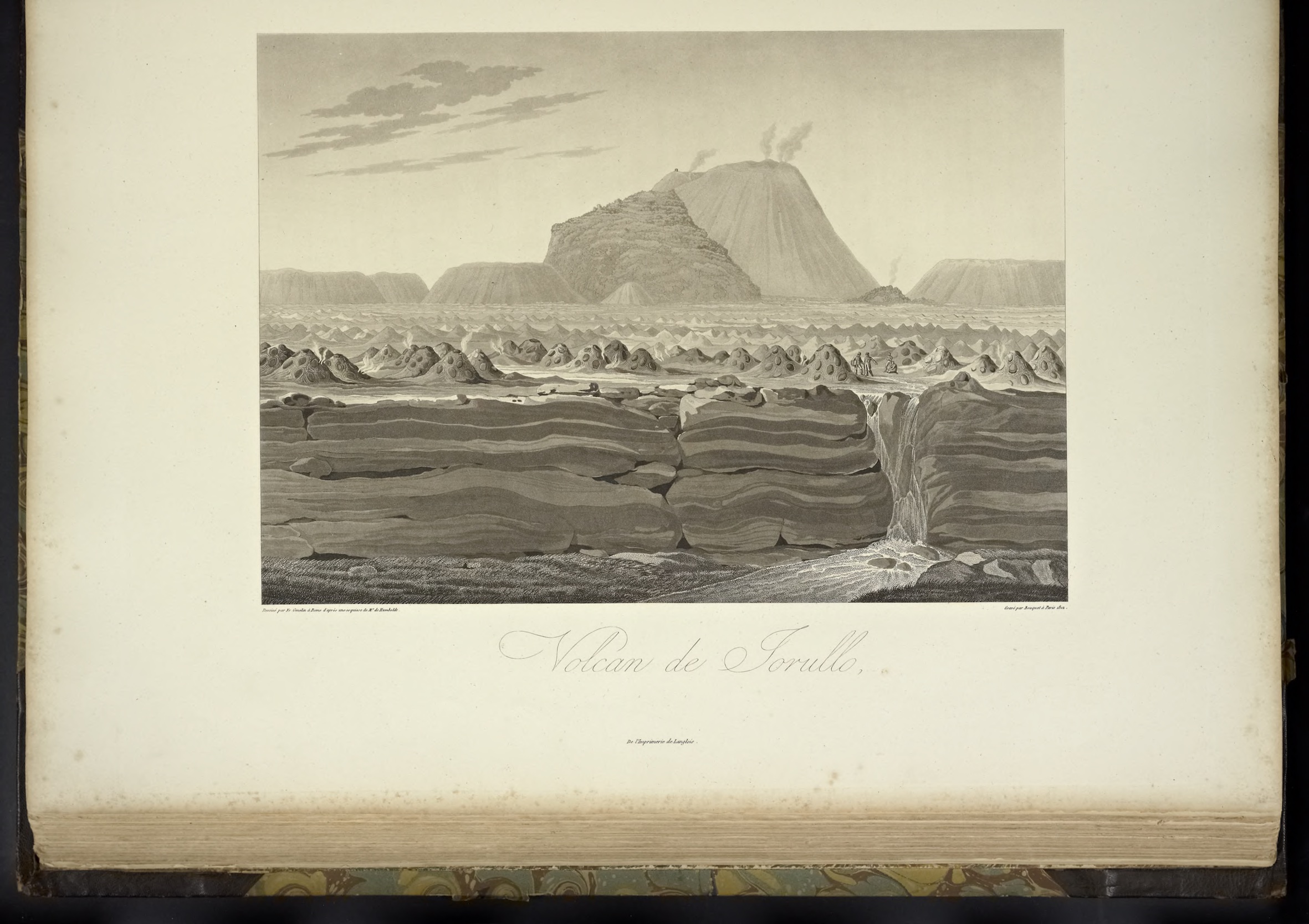
Figure 1 Wilhelm Friedrich Gmelin (drawing), Louis Bouquet (engraving), “Vue de Volcan Jorullo” (View of the Jorullo volcano), in Alexander von Humboldt’s, Vues de cordillères et monuments des peuples indigènes de l’Amérique (Views of mountain ranges and monuments of native peoples of the Americas), v. 2, [Planche XIV], 1810. (Biodiversity Heritage Library).
A visual program was created in Rome involving the relationship of landscape aesthetics with the synthesis of observations and measurements. At this time, the challenge was twofold. On the one hand, Vistas aimed to translate field notes and drawings into significant visual sequences for the public used to the works of Hackert, Gmelin, Johann Christian Reinhart, and Joseph Anton Koch, authors of detailed landscapes of the alpine region and the Roman province. (Bourguet, 2017, pp. 160-161). On the other hand, the engravers had to solve the issue that the veracity that presupposes this ideal is achieved by observing nature, being forced to consider the traveler’s drawings and preparatory sketches.
Humboldt’s sketches disappeared, but fragmentary images of the Jorullo volcano remained in his travel diary, on the sidelines of sheets among lists of measurements or descriptions. One of them is a drawing of "Los Hornitos", a word that Humboldt transcribed from his local interlocutors (Humboldt, 1803, p. IX [88] 55v.) next to Jorullo’s most conspicuous peak (Figure 2). There is a close resemblance between the notebook sketch and the one in Gmelin’s final composition. By contrast, the transformation lies in that the particular image went from a context where it coexisted with graphs and numbers to a framework in which its meaning is linked to the values of certain landscape aesthetics. Undoubtedly, the standard was the “ideal” Neoclassical landscape of the German painters in Rome (the Deutschrömer). their approach was used as a tool to adapt a specific and remote observation to a representation system apprehensible for a community and its visual codes.
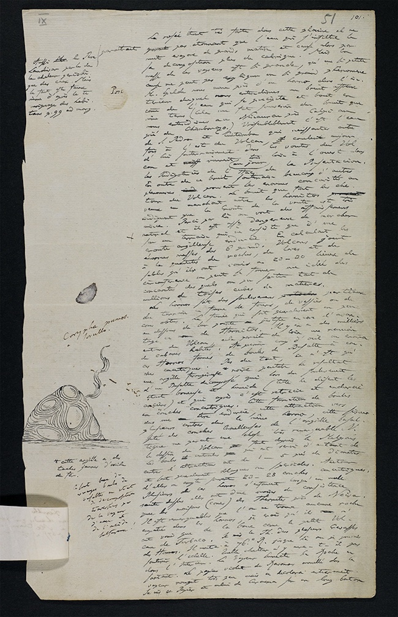
Figure 2 Alexander von Humboldt’s Tagebuch (1803, p. IX, [269] 51 r), Berlin State Library. Available at https://digital.staatsbibliothek-berlin.de/
It is evident that the characteristics of this landscape follow an ideal perspective, a “bird’s eye view”. The typical elements of the landscapes by Gmelin and his group are present in the daring perspective and the representation of figures: the necessary staffage or or figures that communicates scale and monumentality without disengaging the figures in the scene and without presenting them as allegorical matters. To note, with this convention in both the treatment of figures and the perspective, the viewer must accept that the observer of this “natural landscape” faces two contradictory but complementary situations: as a subject that is part of the landscape, or inner observer (the figures portrayed) and as a subject outside the scene. This contract with the viewer is validated on the premise that what is observed in the landscape can be transferred to a painting or an engraving; in the words of the geographer Franco Farinelli, “there is sufficient consistency between the functioning of the world and what is visible” (Farinelli, 2022, p. 62). Thus, it is understood that the idealism depicted in the scene did not diminish the realism of the landscape; on the contrary, there was correspondence between the landscape as a synthetic perception (Totaleindruck), a work of art, and a natural unit. This correspondence is extensive to the physiognomic landscapes of the Vues and the coding of the American spaces (Diener, 2007). The enthusiasm expressed by Leopold von Buch, Humboldt's friend and colleague, after reviewing the images produced reflects this confidence in the full similarity between the knowledge of physiognomy and its visual dimension as a landscape, which were "authentic works of art" for Buch. (Bourguet, 2017, p. 166).
There are indications that the Jorullo landscape was relevant to the geological knowledge of Buch and Humboldt. These come to light through the comparison between the view of Jorullo and the way Buch conceptualized the volcano as a geological phenomenon of the Earth (Buch, 1836, p. 516). In the view located in a place described by
Humboldt as "malpais", the observation opened up to different elements: the uplifting of the land (creating a slope), six main volcanoes, the "hornitos”, later described as “ferruginous clay” mounds, the diversion of the rivers that previously ran across the area, a fracture to the center. Later, in 1826, expanding the volcanic activity concept with the argument that it is impossible to conceive that all the geological “formations” resulted from a single type of eruption, Humboldt proposed that in the Jorullo
[…] three major phenomena were present: the general uplifting of malpais, including thousands of small basaltic cones; the accumulation of slags and other incoherent materials on the hills farthest away from the great volcano, and the lithoid lava expelled by this volcano as a flow (Humboldt, 1826, p. 340).
In a lengthy essay outlining an overview of “positive geognosy” (an empirical science, as opposed to the previous geological systems that seemed speculative), a discussion about the Jorullo was addressed in the final chapter. In particular, the subject of the uplifting of the ground — one of the core elements of Gmelin's composition — was a sensitive topic, as it challenged the idea that the Jorullo's formation type was due to an eruption of lava from a single point, as Jean-François d'Aubuisson de Voisins first thought, who, by not “consulting the cross sections I described in my publication on the Jorullo volcano”, said Humboldt, “assumed that I misinterpreted an uplifted ground with a pile of debris of increased thickness as one approaches the volcanic mouth” (Humboldt, 1826, p. 341). Both Humboldt and Buch argued that the strip of volcanoes running toward the Pacific was the product of a major “crevice”, as mentioned above (Buch, 1836, p. 299), or a “great cleft” in the deep interior of the Earth (Humboldt, 1811, p. 26). The "twenty-five to thirty feet" leap (Humboldt, 1826, p. 338), visible in the Vues landscape, was evidence that the uplifting of the entire malpaís ground resulted from a more general phenomenon and “neither the result of ancient fragments of lava flows nor the result of the breakdown of articulated basaltic prisms or of the fortuitous accumulation of ejections from a distant crater." (Humboldt, 1826, p. 340). Humboldt argued that the "elastic force of vapors" produced the uplift, just as a gas escapes from a viscous surface.
In order to access the unity of the phenomena, the full identification between landscape composition and conceptualization emerged, with both being proof that “the same general laws, according to which the different strata of the Earth’s crust sustain each other, break down as veins or rise due to elastic forces” (Humboldt, 1825, p. 30). Similarly, for Buch, the Jorullo could have a place in his general theory of “elevation craters,” which supposed that the uplifting of the ground results from an internal pressure in the Earth’s crust (Garcia, 2016, Greene, 1982, p. 83). It can be noted how the landscape format, as a physiognomy, when passing from the particular to the general, gave greater significance to the jar of Jorullo gas collected and the notes and drawings, which would otherwise still be disconnected observations. However, as regards the aesthetics of landscape, it is worth noting that, for the sake of achieving a total coincidence of visual forms and the unity of phenomena, all sorts of omissions, translations, and transformations were out of focus, such as transforming an object in accordance with the values of Neoclassical aesthetics, as well as erasing or transforming the proper names of people and objects. An example is that in the later explanation of the volcano in 1826, “hornitos” were later described as Kugelbasalt, replacing their formal description for geological terminology. In that same narrative, the only ones exploring the Jorullo crater were Humboldt and Bonpland, without mentioning their companions, such as the "natives" that carried their instruments.
RUGENDAS AND HARKORT ON THE COLIMA VOLCANO
An oil painting by Rugendas on the crater of the Colima volcano, located on the border of today’s state of Jalisco, painted in 1834, focused on the opening of the volcano’s mouth. The composition is part of the sublime canon; it shows the dangerous proximity to the fire of the Earth's interior. A common feature of Rugendas' work is that the foregrounds are dark, contrasting with a light background. There, a perspective opens up to the vastness of the mountain formations. This technique, carried out with thick brushstrokes as the journey proceeds, serves here to catch the viewer's eye to the center of the volcano, which emits fire and a column of smoke (Figure 3).
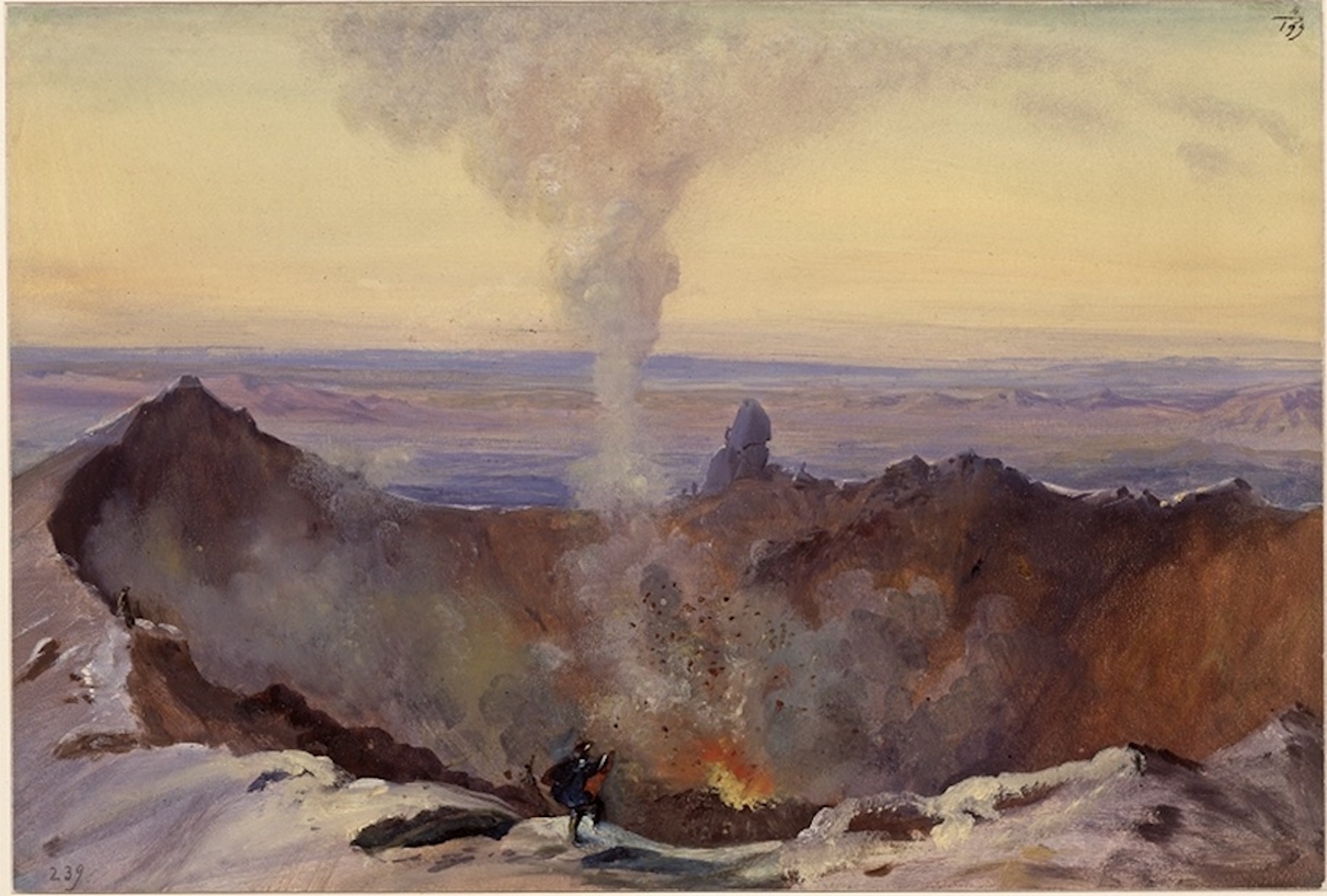
Figure 3 Johann Moritz Rugendas, “Blick in den Krater des Vulkans von Colima” (January- February 1834), Kupferstichkabinett, Staatliche Museen zu Berlin, [VIII E 2617], Berlin.
Between January and February 1834, when Rugendas climbed the Colima volcano, the painter approached from different perspectives, seemingly imposed by the itinerary.
Like Humboldt, Rugendas was not a lonely traveler; he did not live isolated from the social world he explored, and these relationships are also part of the visual material of his landscapes. Although Rugendas’ social relationships were broad, this section focuses on his relationship with Eduard Harkort, a multifaceted miner, geognost, surveyor, serviceman, and entrepreneur. This encounter makes it possible to involve another dimension of the physiognomical in Rugendas' landscapes.
A well-known passage of the correspondence between Humboldt and Rugendas in which the painter recommends him not to travel beyond “10 degrees North latitude and 15 degrees South latitude”, that is, from Central America to southern Peru, has implied that Rugendas’ painting project was almost preconceived according to the valued characteristics of “regions combining palm trees, ferns, cacti, snowy peaks, and volcanoes” (Humboldt, 1830). Nearly the area comprised in the famous Tableau physique des Andes, in the Essai sur la géographie des plantes (Essay on the geography of plants): the focus on mountains and their environmental layers, which was crucial for the development of the new discipline. The correspondence between the scientist and the painter reflects a deep mutual appreciation and a mentor-disciple relationship. It also reveals Rugendas' concerns and objectives (refer to Lima, 2016; Magnin, 2016; González, 2001; Löschner 1992, 1988).
After his return from Brazil and the publication of the Voyage Pittoresque du Brésil, a work that made him known in the travel literature market and earned him some money, Rugendas set out to develop an “American iconography” through a second, more ambitious, journey in which economic interest and fame also prevailed. In this period, before his second trip, Humboldt was not only a model for Rugendas but also acted as his commercial agent, who recommended him and got him buyers and recognitions. On his return from his second trip, fifteen years later, Humboldt continued being a counselor and agent. He proposed to Rugendas to sell his thousands of paintings to the Museum of Natural History in Paris in exchange for a pension; he got him commissions and distinctions with the Prussian monarchy (Humboldt, 1854). Before they represented a fusion between art and science, according to Humboldt's objectives, the value and meaning of these objects were built within his social and commercial networks.
Like Humboldt, Eduard Harkort undertook academic education at the Mining Academy in Freiberg. In 1827, he was awarded a degree with his thesis on using the torch to accurately determine the composition of minerals (Harkort, 1827). He arrived in Mexico in 1828, originally hired by the mining company English Mexican Company. However, he quickly broadened his field as a surveyor, cartographer, and serviceman for Antonio Lopez de Santa Anna, who appointed him chief of engineers of his army (Diener, 1994, p. 100).
After his rise to the presidency in March 1833, Santa Anna was estranged from Harkort, which led to the capture of the latter in May 1835, followed by his deportation (Brister, 2000, p. 124). He first lived in New Orleans and later joined the Texas independentists (Brister, 2000, pp. 14-17), spending his time between battles and trigonometric measurements.
Harkort traveled for four months with Rugendas, from January to April 1834, from Mexico City to the Pacific slope, visiting places such as Valladolid (Morelia), Pátzcuaro, Chapala, and the Colima volcano. During this time, the geognost was commissioned by the municipality of Colima to elaborate a topographic map (Vega, 1842, p. 5). From Colima, on February 9, 1834, Harkort addressed an enthusiastic letter to his Freiberg tutor, August Breithaupt, stating: "A week ago we (of all mortals!) successfully climbed the famous volcano of Colima for the first time. It erupted the last time in 1829. Herr Rugendas made some sketches and paintings on these travels; I made some geographic and geological studies" (Brister, 2000, p. 116). In his letter, Harkort omitted two officials of the Colima City Council who accompanied them, one by the surname Parga and the other Estrada (Vega, 1842, p. 12). Although Harkort's mention of Rugendas attested to a close and mutual collaboration, neither of them was a lone traveler in distant lands; instead, they moved on local circuits and, at the same time, were correspondents of the European knowledge networks, and they also worked as a source of knowledge. However, both were fragile bridges, as the unfortunate fate showed.
With all the materials collected over the trip, Harkort planned to write a book to be entitled “Episodes in the history of the republic of Mexico”, which he never completed. He said to Breithaupt:
"Please tell Professor Kuhn that I have become something of a volcanologist as far as porphyry and basalts are concerned. It is almost impossible not to be, when one sees for hundreds of leagues nothing but large and small volcanoes, nothing but lava flows, porphyry of all sorts, trachyte, and basalts. From my topographical and geognostical map I have set up a geological system on the formation of the whole district of Mexico down to the coast here. My system will be set out in greater detail in my aforementioned book” (Brister, 2000, p. 119).
These lines outline Harkort’s most ambitious project: propose a geological explanation, a true “system” to address the great questions about the dynamics of volcanoes and the origin of minerals that were pressing for scientists (Kruse, 1922, p. XCV, Rudwick, 2005, pp. 181-237). Rugendas' oil paintings can be perceived as physiognomies produced concurrently with Harkort's project. A "central topographic aspect" pointed out by Harkort — the "countless ravines" — led him to propose the geological explanation that these were produced by the volcano's rise over an ancient lagoon whose waters “were altered by volcanic eruptions and followed their course and support at the foot of the limestone mountains, carving the extraordinary ravines through which they now run” (Vega, 1842, p. 10). One of Rugendas’ oil sketches adopted this perspective toward the ravines in the areas descending from the volcano (Figure 4). The pictorial features and the viewpoint selected are important. Through his unique display of light in his oil paintings, a dark foreground is shown that serves as a stage or window toward a broad space traced by the course of the river, which carefully recreates the folds of the relief and the shades of the ground and vegetation. The pastoral scene reflects the transalpine aesthetics of local landscapes of the previous decades and its topographical detail (Mitchell, 1993, pp. 131-133). It is the landscape and physiognomic parallel of what Harkort intends to represent on his map. A copy of this elaborated in 1854 shows Harkort's geographic interests: the volcano, as the driver shaping the region, with the rivers represented in the surroundings, the topography drawn up to the Pacific coast, and, finally, the borderline, in red, of Colima's territory proposed by the author (Figure 5).
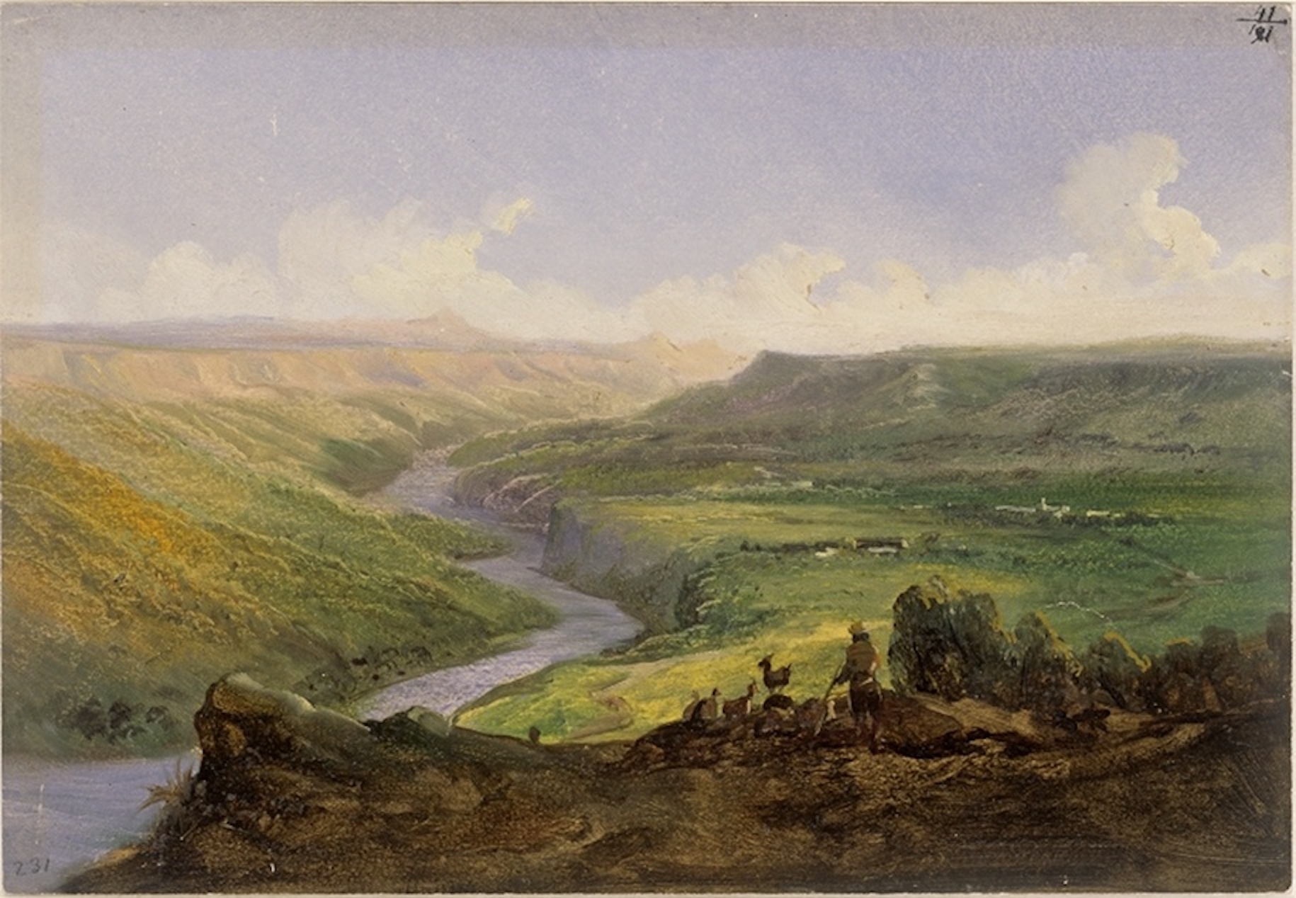
Figure 4 Johann Moritz Rugendas, “EIN Flusstal bei Colima” (January- February 1834), Kupferstichkabinett, Staatliche Museen zu Berlin, [VIII E 2610], Berlin.
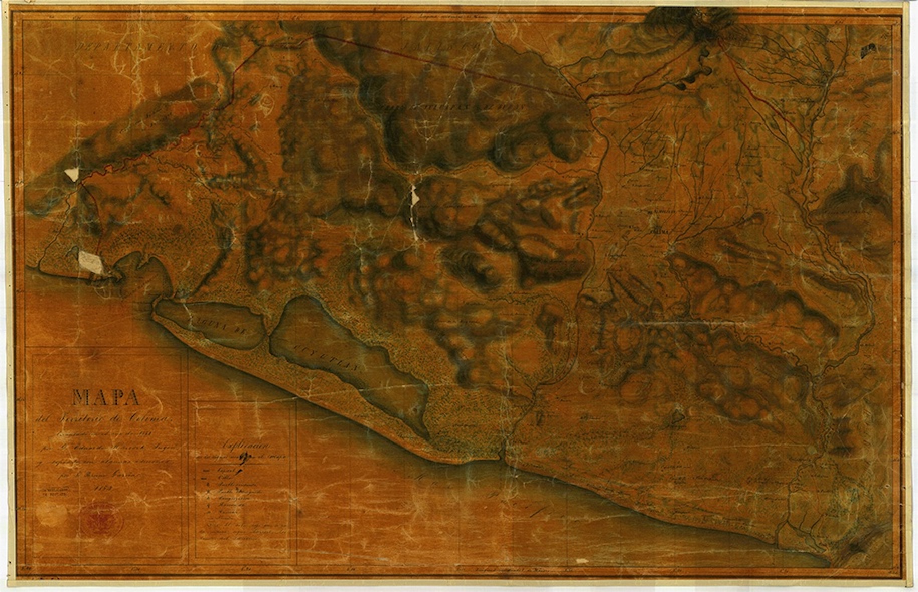
Figure 5 Bruno Garcia, “Mapa del territorio de Colima, levantado en el año de 1834 por D. Eduardo Harcort Ingen., y copiado con algunas adiciones (Map of the territory of Colima, built in 1834 by D. Eduardo Harcort, engineer, and copied with some amendments”, 1854, Mapoteca Manuel Orozco y Berra, No. 1675-OYB-7233-A.
Rugendas adopted perspectives of the volcano that depicted the different types of vegetation according to the change of altitude toward the coast. An oil painting from Zapotlán (Jalisco), north of the volcano, shows vegetation contrasting with that of the Pacific slope, visualized from Tecomán (Colima), including vegetation made of palm trees plus lakes and tropical birds (Figures 6 and 7). In this respect, Harkort describes that "the territory of Colima, small as it is, comprises all the climates, from the snow of volcanoes and the river of the neighboring ranches, the temperate and benign temperament […] to the heat of the coastal beaches and the depths of ravines". This recalls the sort of Humboldt's observation of plant geography; however, this interest was consistent with commercial possibilities, "lucrative things," as he stated. "As a Mexican citizen, I consider myself in the duty to contribute as much as I can to the best knowledge of the country’s resources,” he said, with climates that produce all kinds of agricultural products, with the renovation of the port of Manzanillo and the roads, and with the establishment of a naval school “By improving trade and the navy on the Pacific coast, Mexico will one day become the primary owner of all its waves.” It only takes one mathematics lecturer with his respective instruments, he says. “Harcort offers his services in this regard” (Vega, 1842, p. 19).

Figure 6 Johann Moritz Rugendas, “Indianerdorf am Vulkan von Colima, zwischen Zapotlan und Atenquique im Bereich der Terra Fria” (January-February 1834), Kupferstichkabinett, Staatliche Museen zu Berlin, [VIII E 2608], Berlin.
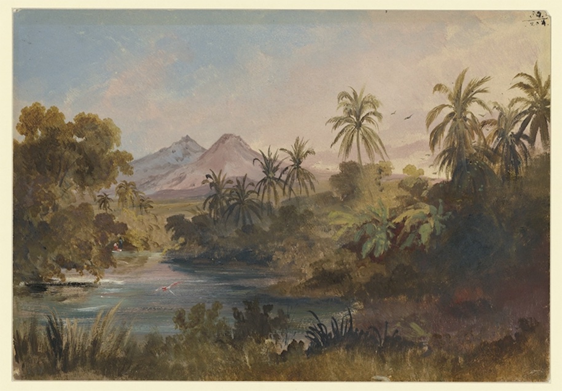
Figure 7 Johann Mortiz Rugendas, “Der Rio Colima mit dem Vulkan und dem Nevado de Colima beim Rancho Cajitlan nahe Tecoman”, (January-February 1834), Kupferstichkabinett, Staatliche Museen zu Berlin, [VIII E 2622], Berlin.
Harkort linked public utility and scientific education from an industrial perspective. The course of events went in a different direction. Harkort had to turn suddenly from an industrial promoter and Mexican citizen into a Texan colonel. Rugendas' itinerary, intended to continue to the northern Pacific coast and California, whose Humboldtian perspective was beginning to be integrated into geographic surveys supported by the local authorities, had to seek other horizons, those of Chile. The geology of volcanoes demonstrated that an event in one place affected another. Harkort argued that the Colima volcano, "through its weight and mass, closed down the way for the interior fire. Consequently, it was forced to find another way out, in the large volcanic vein, and found it in the Jorullo plains” (Vega, 1846, pp. 6-20). Like Humboldt, Harkort, and Rugendas explored the geography of volcanoes.
THE JORULLO OF RUGENDAS AND SARTORIUS
Rugendas collaborated in Christian Sartorius' work entitled Mexico, Landscapes and Sketches on the Life of the People (Mexiko. Landschaftsbilder und Skizzen aus dem Volksleben), published in German in 1852 and later republished in 1855 as Mexico and the Mexicans (Mexico und die Mexicaner), translated into English and Spanish. Sartorius had arrived in Mexico in 1825, fleeing Metternich’s conservative regime (Covarrubias, 2002). He founded a sugar farm in Veracruz and promoted agricultural and industrial modernization. Sartorius presented his work as a synthesis of the country, as a continuation of Humboldt’s Ensayo político de la Nueva España (Political Essay of New Spain) (1811). Moreover, he adopted a regionalization according to different physiognomies: the coast, savannas, perennial forests, pines, and plateaus; he divided his work into chapters based on it and described the volcanoes, particularly the Jorullo and Colima volcanoes. In the section on the Jorullo volcano, he recovered the description of the volcano published in Vues de cordillères and emphasized the changes that were apparent since Humboldt had visited the place, both in the progressive cooling of rocks and the recovery of the vegetation in the area. The engraving, based on a drawing by Rugendas, records a new physiognomy, which then was a basis for the colonization of the territory (Figure 8).

Figure 8 Johann Moritz Rugendas, Jorullo Volcano, Carl Christian Sartorius, Mexico and the Mexicans (London: Trubner & Co, 1859), metal engraving by G. M. Kurz (Internet Archive).
Sartorius was involved in several colonization projects through dense commercial, diplomatic, and scientific networks, such as the Smithsonian Institution and the Berlin Botanical Garden. According to Sartorius, unlike the United States, where German migrants were forced to assimilate, Mexico was a destination where language and traditions could be preserved (Kruse, 1923, p. LXXXIX). Despite this optimism, the relationships of Prussian minister Friederich von Gerolt with the Mexican government showed distrust about the entry of non-Catholic groups, as well as ambivalence, on the Prussian side, between the interest in curbing the U.S. colonization in Mexico and a perception of the poor security offered by the government. (Kruse, 1923, p. LXXXVII). Although it was not what Sartorius and his community expected, the various translations and reissues of his work and Rugendas’s landscapes are evidence of extensive dissemination in Mexico.
In the background, at the center of the painting, we can see the outline of a smoking Jorullo, no longer bare as in Humboldt's lithography but covered with vegetation, with a palm tree (Sabal pumos) standing out at the center and an oak tree on the left, both of which occupy a large area. In his oil sketches on the Jorullo, Rugendas did not emphasize the usual foreground elements. Some versions depict four travelers on horseback, heading toward the volcano. Others only display a scene without persons, emphasizing the topographic elements and the distribution of vegetation (Figure 9). Thus, in the final version of the engraving, Sartorius likely added specific botanical species from other drawings and paintings about the population of the region, which he segregated into races from a physiognomic standpoint. Among those, Sartorius perceived Creole as the country's subject. According to his account, the Creole was a Spaniard transformed by "climate and soil.", a subject who has been nothing but Mexican and rides the central plateaus; they are lawyers, government officers, tradesmen, manufacturers, miners, owners, and architects. What he depicted as the Jorullo's foreground was a "small ranch" that he defined as a type of property corresponding to the local climate. This was a very fertile soil that, "in a small area", produces "a large set of nutritious fruits"; in such a favored region, "all the land could be united through agriculture” and yet it was not exploited (Sartorius, 1859, pp. 48-61). Sartorius stressed the need to colonize this abundant tropical land through an argument stemming from physiognomy.
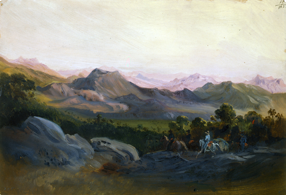
Figure 9 Johann Mortiz Rugendas, “Der Vulkan Jorullo", (1834), 24,3 x 35,5 cm, Kupferstichkabinett, Staatliche Museen zu Berlin, [VIII E 2584], Berlín.
A brief essay to promote German emigration, published by Sartorius in 1849, was translated and printed in the country in 1851 by Augustine S. de Tagle, who dedicated it to Mariano Galvez, then Secretary of colonization and industry (Sartorius, 1852) (the Dirección de Colonización, which preceded the Ministerio de Fomento, was created in 1846) (Burden, 2007). It was later published in José Joaquin Pesado’s Revista Mexicana de la Sociedad Promovedora de Mejoras Materiales (Mexican Journal of the Society Promoting Material Improvements) in 1852 (Langman, 1949). Sartorius' meteorological observations on his estate were published in the Boletín de la Sociedad Mexicana de Geografía y Estadística (Bulletin of the Mexican Society of Geography and Statistics); these were even taken up and compared with new measurements in 1882, seeking to find the best climate to establish an Italian colony in Veracruz (Bárcena and Ruiz, 1882). This process shows how the Humboldtian visual knowledge was turned into a powerful argument for capitalist modernization or the implementation of “more liberal business principles,” as Sartorius stated (1859, p. 178).
It is not mere rhetoric that Sartorius concluded his work by depicting a mine as the backbone of the society:
The miners, however, bring forth the nervus rerum, which, like a powerful magnet, attracts and animates. At length come the arts and sciences, bestowing civilization on the shapeless mass, producing order in the chaos, introducing mind into that which could hitherto be regarded as matter only. Shooting up overnight like a huge fungus, a mining-town affords us an image of the organic life of human society, elsewhere developing itself slowly, but according to the same laws (Sartorius, 1859, p. 202).
This expression is part of a Humboldtian complex that combines physiognomy, landscape, race, economy, and progress. Rugendas’ paintings of the mines of central Mexico could be interpreted from this perspective.
CONCLUSIONS
Thinking of a “Humboldtian landscape complex” allows for assessing the effects of the disciplines projected by Humboldt in large communities, as well as in the development of Geography and Geology through different initiatives and local institutions. Likewise, understanding the Humboldtian landscape as a setting of dynamic social interrelations allows for analyzing its historical changes instead of subjecting it to prescriptive concepts such as "Humboldtian science". Thus, it is hereby proposed that thinking about the "Humboldtian landscape complex" involves becoming aware of a heterogeneous social knot and a field of trajectories instead of a stable representation. This also allows qualifying the views of those who contend that the representation of the American landscape only obeys the colonial ideology or of those who observe Humboldt's visual epistemologies without referring to his practical, political, and social worlds.
It has been stated that the romantic and picturesque landscape was key in the visual construction of American nature, seen as a source of colonial and neo-colonial riches (Araujo, 2015; Sutter, 2014; Wilie, 2009; Arnold, 2006; Stepan, 2001; Heizer and Ormindo, 2018; Driver and Martins, 2005). The historian David Arnold (2006, p. 6) has stated that these picturesque landscape representations were strategies for legitimizing the power of colonizers over those colonized and arguments for the necessary modernization of the latter. The cases of Harkort, Sartorius, and Rugendas offer nuances to such processes.
As Amar Wahab (2010, p. 12) affirms about the Caribbean, the landscape, with its economy of gestures, “does not always preserve the dialectical power relations between both subjects [the one that represents and the one who is — or which is — represented] in the same way in any given moment”. It should be noted that these representations were linked to the most open forms of colonization only surreptitiously and should be understood in a broad spectrum of academic, mining, and industrial practices carried out through dense networks of collaborators. It can also be observed that the interplay between landscape, knowledge of Geography and Geology, and the role of the colonizer was used in various ways by local institutions.
In summary, it has been seen that the Neoclassical landscape of German painters in Rome was used to add meaning to the specific observations of Humboldt and Bonpland.
Beyond illustrating the places visited, the landscape was related to the epistemology of fieldwork. In the case of the Jorullo volcano representation, the landscape, as physiognomy, was involved in the synthesis of the geological explanation. Later, although Rugendas’ journey has been interpreted as the continuation of Humboldt’s mission about the American landscape, the painter’s social world shows that the development of this genre also responded to the market (i.e., the demand for paintings) and to a network of relations in the geopolitical space. Likewise, the geological and geographic research that involved this landscape was imbued with mining practices and their role in industrial development. This is represented by Eduard Harkort, a character moved by the interest of the transnational mining companies after the opening of the colonies, as well as by the sudden political circumstances of the country.
Humboldt, Harkort, Sartorius, and indeed Rugendas belonged to societies marked by industry and, especially, mining. The objective of the present work was to outline the relationship between key concepts put forward by Humboldt, such as physiognomy, and the industrial and practical horizons in which such concepts emerged and evolved. As Patrick Anthony argues: "Like many before and after him, Humboldt walked the fine line between what he described as the ‘outer’ and ‘inner aims of the sciences’, between his investment in utility and the authority he gained from disinterestedness” (Anthony, 2018, p. 31).
Finally, this article points out how the Germans living in Mexico, such as Carl Christian Sartorius, used the same physiognomic concept of the landscape to promote the regionalization of the country and a typology of its population to promote agricultural and industrial colonization. Remarkably, this perspective was adopted by various Mexican actors and institutions. The empiricist and scientific landscape had become a social and political geography that articulated representations of global political and economic interrelations.
REFERENCES
Achim, M, Goldin, G. (2023). Air in a Flask. The Mexican Making of Humboldt’s Objects of Knowledge. En M. Thurner y J. Cañizares-Esguerra (Eds.), The Invention of Humboldt. On the Geopolitics of Knowledge (pp. 233-258). Routledge., [ Links ]
Anthony, P. (2018). Mining as the Working World of Alexander von Humboldt’s Plant Geography and Vertical Cartography, Isis, 108(1), 28-55. [ Links ]
Araujo, A. L. (2015). Brazil through French Eyes: A Nineteenth-century Artist in the Tropics. University of New Mexico Press. [ Links ]
Arnold, D. (2006). The Tropics and the Traveling Gaze. India, Landscape, and Science, 1800-1856. University of Washington Press. [ Links ]
Bárcena, M., Ruíz, G. (1882). Estudio físico-médico de los terrenos de Huatusco y el Tizar en el estado de Veracruz. Anales del Ministerio de Fomento de la República mexicana, 7, 271-305. [ Links ]
Bourget, M. N. (2017). Le monde dans un carnet. Alexander von Humboldt en Italie (1805). Éditions du Félin. [ Links ]
Brister, L. E. (1986). In Mexican Prisons. The Journal of Eduard Harkort, 1832-1834. Texas A&M University Press. [ Links ]
Buch, L. v. (1836). Description Physique des Îles Canaires, suivie d’une indication des principaux volcans du globe. F. G. Levrault. [ Links ]
Burden, D. K. (2007). Reform Before La Reforma: Liberals, Conservatives and the Debate over Immigration, 1846-1855, Mexican Studies, 23(2), 283-316. DOI: https://doi.org/10.1525/msem.2007.23.2.283 [ Links ]
Covarrubias, J. E. (2002). Carl Christian Sartorius y su comprensión del indio dentro del cuadro social mexicano. En M. Ferrer, La imagen del México decimonónico de los visitantes extranjeros: ¿un Estado-nación o un mosaico plurinacional? (pp. 217-236). Instituto de Investigaciones Jurídicas, UNAM. [ Links ]
Debarbieux, B. (2012). Figures et Unité de l’idée de montagne chez Alexadre von Humboldt, Cybergeo, 617, 2-25. [ Links ]
Dettelbach, M. (2005). The Stimulations of Travel: Humboldt’s Phyisological Construction of the Tropics. En L. Martins y F. Driver, Tropical Visions in an Age of Empire. The Universtiy of Chicago Press. [ Links ]
Dettelbach, M. (2000). Humboldtian Science. En N. Jardine, J. A. Secord y E. C. Spary, Cultures of Natural History (pp. 287-304). Cambridge University Press. [ Links ]
Dettelbach, M. (1999). The Face of Nature: Precise Measurement, Mapping, and Sensibility in the Work of Alexander von Humboldt, Stud. Hist. Phil. Biol & Biomed. Sci., 30(4), 473-504. [ Links ]
Diener, P. (1994). Rugendas: imágenes de México, Bilder aus Mexico. Conaculta, INAH, Instituto Goethe. [ Links ]
Diener, P. (2007). The picturesque as an aesthetic category in the art of travelers: notes on J. M. Rugendas’s work, Historia, 3, 285-309. [ Links ]
Diener, P., Costa, M. F. (1998). Juan Mauricio Rugendas, Pintor y dibujante. Hamburg Gráfica. [ Links ]
Diener, P., Costa, M. F. (2012). Rugendas e o Brasil, Capivara Editora. [ Links ]
Driver, F, Martins, L. (2005). Tropical Visions in an Age of Empire . The University of Chicago Press. [ Links ]
Farinelli, F. (2022). Polifemo cegador. La geografía y los modelos del mundo, [trad. Clara Ferri]. Geografía para el siglo XXI, Textos universitarios, 31. Instituto de Geografía, UNAM. [ Links ]
García, C. M. (2016). Leopold von Buch (1774I-1853), las islas Canarias, y el origen de la teoría de los cráteres de elevación, ILUIL, 38(83), 73-101. [ Links ]
González, B. (2001). La escuela de paisaje de Humboldt. En El regreso de Humboldt. Museo de la Ciudad de Quito. [ Links ]
Greene, M. T. (1982). Geology in the Nineteenth Century. Changing Views of a Changing World. Cornell University Press. [ Links ]
Harkort, E. (1827). Die Probirkunst mit dem Löthrohre oder Versuch einer Anweisung, wie man Erze, Mineralien und Hüttenproducte mit Hülfe des Löthrohrs auf verschiedene Metallgehalte mit hinreichender Genauigkeit unterfuchen kann, von Eduard Harkort. Gerlach. [ Links ]
Havenon, G. de, Lubowski, A. E. (2014). Unity of Nature: Alexander Von Humboldt and the Americas. Americas Society, Kerber Verlag. [ Links ]
Heizer, A., Ormindo, P. (2018). Natureza, ciência e arte na viagem pelo Brasil de Spix e Martius 1817-1820. Andrea Jakobsson Estudio. [ Links ]
Heringman, N. The Style of Natural Catastrophes, Huntignton Library Quarterly, 66(1/2), 97-133. [ Links ]
Humboldt, A.v (1803) Tagebuch IX 1803-1804 [Diario de viaje IX 1803-1804] Biblioteca estatal del Berlín: https://humboldt.staatsbibliothek-berlin.de/work/?lang=en [ Links ]
Humboldt, A. v. (1830). Carta de Alexander von Humboldt a Johann Moritz Rugendas, Berlín, 8 de marzo de 1830, [1 v]. http://resolver.staatsbibliothek-berlin.de/SBB0002D4BD00000000 (Digitalisat) [ Links ]
Humboldt, A. v. (1854). Carta de Alexander von Humboldt a Johann Moritz Rugendas, Berlín, 25 de febrero de 1854. https://edition-humboldt.de/v8/H0019728. [ Links ]
Humboldt, A. v. (1816 [1810]). Vues de Cordillères et monumens des peuples indigenes de l’Amérique (2 vols). N. Maze. [ Links ]
Humboldt, A. v. (1825). Sobre la estructura y la acción de los volcanes en distintas zonas de la Tierra. En O. Lubrich y T. Nehrlich (Eds.), (2021), Alexander von Humboldt. Escritos (v. 2, pp. 24-52). Herder, Instituto Goethe. [ Links ]
Humboldt, A. v. (1849). Cosmos: A Sketch of a Physical Description of the Universe (5 vols.). Henry G. Bohn. [ Links ]
Humboldt, A. v. (1999). Cuadros de la naturaleza. Siglo XXI, SEP. [ Links ]
Kwa, C. (2005). Alexander von Humboldt’s Invention of the Natural Landscape. The European Legacy, 10(2), 149-162. [ Links ]
Kruse, H. (1923). Deutsche Briefe aus Mexiko. G. D Baedefer. [ Links ]
Langman, I. K. (1949). Dos figuras casi olvidadas en la historia de la botánica mexicana, Rev. Soc. Mex. Hist. Nat., 10(1-4), 329-336. [ Links ]
Lima, A. C. (2016). A floresta sublime nos óleos de Rugendas A influência da cultura alemã na criação do artista. Novas Edições Acadêmicas. [ Links ]
Löschner, R. (1988). Alexander von Humboldt. Inspirador de una nueva ilustración de América. Artistas y científicos alemanes en Sudamérica y México. Instituto Ibero-Americano Patrimonio Cultural Prusiano. [ Links ]
Löschner, R. (1992). Johann Moritz Rugendas in Mexiko. Ein Maler aus dem Umkreis von Alexander von Humboldt. Ibero-Amerikanisches Institut zu Berlin. [ Links ]
Lubowski, A. E. (2009). The Picture of Nature: Alexander von Humboldt and the Tropical American Landscape. Tesis doctoral, New York University, Institute of Fine Arts. [ Links ]
Magnin, L. (2016). Les peintures de paysages de Johann Moritz Rugendas: un exemple de transferts artistiques entre Europe et Amérique latine au XIXe siècle, Artl@s Bulletin 5(1), 24-37. [ Links ]
Mattos, C. V. (2008) Goethe e Hackert. Sobre a Pintura de Paisagem. Atelié Editorial. [ Links ]
Mitchell, T. (1993). Art and science in German landscape painting 1770-1840. Oxford Clarendon Press. [ Links ]
Nieto, M. (2018). Orden natural y orden social. Ciencia y política en el Seminario del Nuevo Reyno de Granada. Ediciones Uniandes. [ Links ]
Nulman, A. (2021). Eugenio Landesio y la teoría del paisaje. Tesis de doctorado, UNAM. Disponible en http://tesiunam.dgb.unam.mx/ [ Links ]
Ortiz, E. (2013). Memorias de un artista apasionado, J. M. Rugendas. Luna Libros. [ Links ]
Podgorny, I. y Schäffner, W. (2000). La intención de observar abre los ojos. Narraciones, datos y medios técnicos en las empresas humboldtianas del siglo XIX. Prismas, 4, 217-227. [ Links ]
Porter, M. (2005), Windows of the Soul. Physiognomy in European Culture 1470-1780, Clarendon Press, Oxford. [ Links ]
Roquette, M. d. l. (1869). Oeuvres d’Alexandre de Humboldt. Correspondance Inédite Scientifique et Littéraire, L. Guérin et Cie. Éditeurs. [ Links ]
Rudwik, M. J. S. (2005). Bursting the Limits of Time. The Reconstruction of Geohistory in the Age of Revolution. The University of Chicago Press. [ Links ]
Sartorius, C. (1852). Importancia de México para la emigración alemana, Tipografía del Editor, Exconvento del Espíritu Santo. [ Links ]
Sartorius, C. (1859). Mexico. Landscapes and Popular Sketches. Trübner & Co. [ Links ]
Schmid, F. C. (2011). Wilhelm Friedrich Gmelin, Print Quarterly, 28(2), 203-205. [ Links ]
Stepan, N. L. (2001). Picturing Tropical Nature. The University of Chicago Press. [ Links ]
Sutter, P. (2014). The Tropics: A Brief History of an Environmental Imaginary. En A. C. Isenberg, The Oxford Handbook of Environmental History (pp. 178-204). Oxford University Press. [ Links ]
Vega, R. d. l. (1842). Noticias geográfico-políticas del territorio de Colima, escritas por el coronel ingeniero D. Eduardo Harcort, en el año de 1831, publicadas en 1842, por Don Ramón de la Vega. S. Pérez. [ Links ]
Wahab, A. (2012). Colonial Inventions: Landscape, Power and Representation in Nineteenth-Century Trinidad. Cambridge Scholars Publishing. [ Links ]
Wilie, L. (2009). Colonial Tropes and Postcolonial Tricks: Rewriting the Tropics in the novela de la selva. Liverpool University Press. [ Links ]
Zerpa, J. J. (2016). La obsidiana en la investigación de los volcanes europeos e hisspanoamericanos (1735-1799), Letras históricas, 14, 51-86. [ Links ]
1As Martin Porter investigates, the physiognomy concept can be traced back to hermeticism. Directly referring to Humboldt's case, he states: "It can be said that a more 'esoteric' form of physiognomy has contributed to the growing definition of parameters in the development of scientific knowledge of nature” (Porter, 2005, p. 31).
Received: February 14, 2023; Accepted: March 15, 2023; Published: March 29, 2023
 Este es un artículo publicado en acceso abierto bajo una licencia
Creative Commons
Este es un artículo publicado en acceso abierto bajo una licencia
Creative Commons
