


Servicios Personalizados
Revista
Articulo
 texto en
  Inglés (pdf)
 Artículo en XML
 Referencias del artículo
 Enviar artículo por email
Indicadores
-
 Citado por SciELO
 -
 Accesos
Links relacionados
-
 Similares en
SciELO
Similares en
SciELO
Compartir

 Permalink
Investigaciones geográficas
versión On-line ISSN 2448-7279versión impresa ISSN 0188-4611
Invest. Geog no.110 Ciudad de México abr. 2023 Epub 26-Jun-2023
https://doi.org/10.14350/rig.60678
Articles
Saving, Filing and Collecting Old Maps. Routes in the Conformation of Map Libraries: Two Cases in Chile and Argentina

*CONICET-HiTePAC. Instituto de Investigaciones en Historia, Teoría y Praxis de la Arquitectura y la Ciudad, Facultad de Arquitectura y Diseño, Universidad Nacional de la Plata, Argentina.
**Universidad de Chile. Centro de Estudios Culturales Latinoamericanos, Facultad de Filosofía y Humanidades. Email: alvega@uchile.cl
***HiTePAC-UNLP. Instituto de Investigaciones en Historia, Teoría y Praxis de la Arquitectura y la Ciudad, Facultad de Arquitectura y Diseño, Universidad Nacional de la Plata, Argentina. Email: terezweifel@gmail.com
This study discusses the Ancient Map category that is recurrent in the literature on the history of cartography. To this end, we analyzed two cases — one in Chile and the other in Argentina — which, despite their unique characteristics and differences between them, share common features. These allow for concluding that the designation of maps as old does not strictly refer to the passage of time but results from a set of factors, including ideological, institutional, contextual, and material aspects. In this sense, this article contributes to the field of studies addressing the history of cartography, the history of collections and archives, and their intellectual foundations in a period spanning from the late 19th century to mid 20th century.
The first map library analyzed corresponds to the collection gathered by the bibliophile, editor, and historian José Toribio Medina (1852-1930), which today is part of the Medina Room at the National Library of Chile. This collection was created in the last decade of the 19th century and is currently one of the main cartographic collections of Chile, along with the Map Library of the National Archive and the Map Library of the National Library.
The second map library belongs to the Department of Historical and Cartographic Research of the Province of Buenos Aires (Geodesy Archive). In this case, the cartographic collection corresponds to an archive and is the result of the submission of materials derived from the work of the surveying technicians, who were requested to deliver a copy to the institution. José Maria Prado (1896-2002), a government officer credited with reevaluating these materials for new uses of technically obsolete maps, was involved in the review of this archive.
We analyzed the texts related to the conformation of both map libraries: notes, descriptions, catalogs, and other documents of the time. The analysis of these materials revealed that the formative processes of both map libraries share at least two common aspects: the unintentional, unplanned practice that gave rise to them; and the close relationship between the valuation of the cartographic collection and the aim to recount a history of cartography and the territory; the combination of both characteristics defines the antiquity of the map. When identified as ancient, the cartographic material was available to undergo various historiographical processes. These maps would be used to build genealogies of the national or provincial present by becoming a material imprint of past truths or ancient testimonies of lasting truths; or, by evidencing their obsolescence, introducing a critical distance from past events.
As a result, a patina was recognized that granted these maps renewed validity and legitimacy, regardless of their effective material characteristics. This conception even justified that besides the maps that had already been given the ancient status, others could be added, which, being contemporary, were bound to become obsolete through time.
Keywords: Argentina; Chile; ancient maps; colection; archive
Esta investigación discute la categoría de Mapa Antiguo que encontramos de manera recurrente en la bibliografía referida a la historia de la cartografía. Para ello se analizan dos casos -uno chileno y otro argentino- que, si bien tienen singularidades y diferencias, comparten algunos aspectos que nos permite concluir que lo antiguo de los mapas no remite al paso del tiempo en sentido estricto sino que es el resultado de un entramado de cuestiones, en las que intervienen determinantes ideológicas, institucionales, coyunturales y materiales. En tal sentido, este artículo contribuye al campo de estudios de la historia de los mapas, de la historia del coleccionismo y los archivos y de sus fundamentos intelectuales en un periodo que abarca desde finales del siglo XIX a mediados del siglo XX.
La primera mapoteca analizada corresponde a la colección reunida por el bibliófilo, editor e historiador José Toribio Medina (1852-1930), y que hoy forma parte de la Sala Medina de la Biblioteca Nacional de Chile. Esta colección se compuso desde el último decenio del siglo XIX y es actualmente -junto a la Mapoteca del Archivo Nacional y la Mapoteca de la Biblioteca Nacional- uno de los principales acervos cartográficos de Chile.
La segunda mapoteca corresponde al Departamento de Investigaciones Históricas y Cartográficas de la Provincia de Buenos Aires (Archivo de Geodesia). En este caso, el acervo cartográfico corresponde a un archivo y es resultado del sedimento de materiales del trabajo de los técnicos agrimensores que, por obligación, debían entregar un ejemplar en la institución. Sobre este archivo, interviene José María Prado (1896-2002), funcionario a quien se le atribuye la revalorización de dichos materiales para nuevos usos de mapas técnicamente obsoletos.
Se procedió analizando los textos producidos como correlato de la conformación de ambas mapotecas: notas, descripciones, catálogos y otros documentos de época. El análisis de estos materiales permitió observar que los procesos formativos de ambas mapotecas comparten al menos dos aspectos en común: la práctica no intencionada, no planificada, que les da origen, y la estrecha relación que se establece entre la valoración del acervo cartográfico y la pretensión de contar una historia de la cartografía y del territorio. Es en la conjunción de ambas características que se define lo antiguo del mapa. Al identificarse como antiguo, el material cartográfico quedaba habilitado para sustentar diversas operaciones historiográficas. Con estos mapas se podría construir genealogías del presente nacional o provincial al constituirse en huella material de verdades pasadas o testimonios antiguos de verdades duraderas, o bien, al explicitar su obsolescencia, introducir una distancia crítica respecto de lo ya acontecido.
Como resultado, se les reconoció una pátina que, con cierta independencia de sus características materiales efectivas, les otorgaba renovada vigencia y legitimidad. Incluso, esta concepción justificaba que al lado de los mapas que ya habían adquirido la condición de antiguos, pudieran figurar otros que, siendo contemporáneos, estaban llamados a tornarse obsoletos con el paso del tiempo.
Palabras clave: Argentina; Chile; mapa antiguo; colección; archivo
INTRODUCTION
We take it for granted that ancient maps exist and that they constitute a valuable testimony of knowledge and practices of understanding and representation of the space in the past. These are portrayed as such by their being found in repositories or institutions that so acknowledge it and by sharing characteristics with other materials assigned to the same status: historical and documentary heritage. In Françoise Choay, we find a “nomadic” definition of heritage that takes over the historical contexts in which it is defined, invoking both an institutionality and a mentality (2007, p. 7). This conception allows us to advance with respect to the assertion that the ancient object “is where it is to conjure time”, as Jean Braudrillard (1969, pp. 83-84) pointed out, recognizing that this attribute is an effect rather than a starting point. It can even be a transient condition. Referring particularly to the universe of maps, we adopted the proposal of Carla Lois (2015a), who recalls that these have an unstable meaning, subject to their uses and interpretations.
In his studies on the history of cartography, Harley (1987) argued that there was an interest in earlier maps since the Renaissance, although their historical value was not immediately apparent but became evident over time (p. 7). Their connection with the ideas of time and historicity can be inserted within the framework of that general displacement that placed historical evolution and progress categories at the core of the interpretation of being human. Identifying certain objects as ancient maps had to be reinforced as the notion of the map as a scientific and precise instrument was consolidated. This vision supported the formalization of cartography as a discipline in the nineteenth century (Edney, 2005, p. 15; Harley, 1987, p. pp. 12-15) that, in Latin America, was linked to the formation of the Republican State and the political map of the nation (Muñoz Arbeláez, Díaz Ángel y Nieto Olarte 2013; Lois, 2014, 2015b; Mendoza Vargas, 1993, 2000; Moncada Maya, 2002; Sagredo, 2009). In this context, the ancient map concept was used to evaluate different types of cartographic materials and identify those that did not depict the territory as the Republican State intended.
This was the context where the revaluation of pre-existing cartographic archives and the consolidation of map collecting took place. In the first case, archives emerged as the forgotten material of various cartographic practices that acquired heritage value due to the interaction between different actors and institutions, the latter mostly state agencies. In the second, the antiquarian vocation admitted the collection of certain artifacts of the past that was being shaped and defined in specific areas, such as the collecting of maps, dialoguing with the development of a task that claimed scientific validity (Edney, 2021; Harley, 1987; Podgorny, 2011).
Archiving. Collecting. Both practices currently enjoy the prestige conferred by the patina of the old1. As a dimmed version linked to the manual and material endeavor, we rescue the term “safeguard”. In its nineteenth-century sense, safeguarding was “taking care of something or someone, monitoring and defending it. Keeping something where it is safe. Maintaining, observing. Preserving or retaining something” (Dictionary of the Spanish Language, 1869, 1914, and 1992). Our reflection in the present article focuses on this practice —and the emergence of ancient as a feature.
This article aims to analyze two map libraries corresponding, respectively, to a collection and an archive2: The cartographic collection of the Medina Room of the National Library of Chile, which started in the late nineteenth century, and the archive of the Department of Historical and Cartographic Research of the Province of Buenos Aires, hereafter Geodesy Archive, which largely corresponds to an institution of the first half of the twentieth century. Other than the specific studies of the authors (Vega, 2018; Zweifel, 2021), there are no works critically addressing these collections.
On the one hand, it seeks to understand how the cartographic heritage concept was forged in relation to the work and storage practices in each case. On the other hand, we explore the impact of the expectation of elaborating a historiographic account in the formalization of these repositories. The relationship between cartographic production and national-state narrative is already common in the history of cartography (Anderson, 1993; Harley, 1987; Lois, 2002, 2014; Nadal and Urteaga, 1990; Sagredo, 2009, 2018a). In this case, we explore an extension of this idea in relation to the formation of specific map libraries in Latin America.
The perspective adopted leads us to recognize two players — José Toribio Medina and José Maria Prado — as players of specific historical processes. In the words of Terry Cook (2010): “the ‘archive’ (singular) of society cannot be found [simply] in ‘archives’ (plural). Archivists significantly shape and modify this archive” (p. 154). Along these lines, the present study seeks to locate the archiving works that both actors deployed as an expression of practices framed within a cultural and institutional horizon in which they made sense.
CARTOGRAPHIC COLLECTION OF THE JOSÉ TORIBIO MEDINA AMERICAN LIBRARY: FROM ARCHIVING TO COLLECTING ANCIENT MAPS
The Sala Medina of the National Library of Chile safeguards a collection of about 2,200 maps (Biblioteca Nacional de Chile, 2006, p. 38). Along with the Map Library of the National Archive and the Map Library of the National Library, it concentrates a large part of the cartographic heritage of Chile (Vega, 2018). The collection is part of the donation by José Toribio Medina to the National Library of Chile, which was gathered in a patrimony room. Its materialization is the result of Medina’s archiving practices between 1870 and 1920, as described below.
José Toribio Medina (1852-1930) is recognized as a bibliophile, collector, author, translator, and editor of bibliographic series, documentary collections, and catalogs, and has an extraordinarily prolific production by any standards (Rovira, 2002; Sagredo, 2018b). Son of a lawyer, he studied law and was given the opportunity to join the political work of the country as a deputy, which he rejected. Instead, he took another path commonly followed in the intellectual field of those years, assuming various commissions and appointments in the government organization, both in Chile and abroad (Rovira, 2002, pp. 53-55). In Chile, these were the years of oligarchic rule in a context marked by the economic modernization and infrastructure project promoted by this elite. These were also the years of a “new and active process of the intellectual and symbolic construction of the nation” (Subercaseaux, 2011, p. 10). It was within this framework that Medina built his cartographic collection.
In the whole of Medina’s intellectual work, cartography was given a secondary place. The first certain news about his maps dates back to 1889, when he published his Ensayo de una mapoteca chilena (Essay on a Chilean Map Library). Ó sea, de una colección de los títulos de los mapas, planos y vistas relativos á Chile arreglados cronológicamente, con una introducción histórica acerca de la geografía y cartografía del país (That is, from a collection of the chronologically arranged titles of maps, drawings, and views relating to Chile, with a historical introduction to the country’s geography and cartography (hereinafter Essay)3. As stated in the foreword of that work:
Over the course of my research on the history of Chile, I had the opportunity to record the titles of maps and drawings related to this country that caught my attention, with no intention of writing a book. After a while, I realized that my notes had grown to such an extent that it seemed to me that by organizing and completing them with the titles of the maps I owned or that I knew existed scattered in more-or-less known works, they could form a body of interest for our cartographic history, which is currently missing (Medina, 1889a, p. v).
Three issues are worth highlighting from this fragment: 1) Medina reports that “he had maps”; 2) he states that, in the beginning, he had no intention of writing a book from the cartographic material in his possession or that he knew by reference. To endorse the somewhat incidental, unintentional, and non-priority character of his enterprise, he acknowledges, almost surprised, having found “that my notes had grown to such an extent ”; and adds: “Thus, I do not intend, in any way, that the work appears comprehensive”, arguing, among the causes, that “other more relevant tasks demand my working hours” (Medina, 1889a). Finally, it is interesting to note that Medina conceived his collection of map titles within the framework of a specific intellectual project: the history of Chile and the claim of the national territory. Sagredo has already proposed that this work should be placed in a context where Latin American states need to build previous data to defend positions in the border disputes they face (2021, p. 233). We believe this is also a key aspect in the conception of the cartographic collection as such.
We do not know when Medina acquired his first maps or under what conditions. Given the lack of documentary evidence, we can only imagine him starting the work that would consolidated in its cartographic collection around the same period when he planned his huge research and compilation program on American printed books and the copying of textual manuscript documents on the colonial history of Chile (Rovira, 2002, p. 62). Events that should be considered milestones in this process are his stay in Lima and the first of his trips to several cities in the United States and Europe (1874-1877), followed by his appointment as Secretary of the Chilean legation in Spain between 1884 and 1886 (Donoso, 1915, pp. 38-41).4
Medina does tell us that during these trips, he “recorded the titles of maps and drawings relating to this country” (Medina, 1889a, p. v), which he ended up publishing in two formats in 1889: as the main body of the Essay and, separately, as a Catálogo de la colección de mapas, planos y vistas relativos a Chile (Catalog of the collection of maps, drawings, and views relating to Chile), which was published that same year (hereafter, the 1889 Catalog). These works comprise five cartographic5 sections, each including a list of maps numbered following a temporal sequence.
We ignore which were all the map libraries visited by Medina during his travels, nor how these visits influenced his understanding of cartographic material. What we do know are the institutions mentioned as archives of the direct sources of his Essay: the General Archive of the Indies, the Hydrographic Archive of Madrid, the Depôt-General de la Marine, and the catalogs of the E Dufosse Library of Paris, the Hydrographic Office of the Admiralty of London, the British Museum Library, and what he describes as “the rich cartographic collection” of Manuel Rico and Sinobas in Madrid (Medina, 1889a, p. viii).
All the maps owned by him were identified in the collection of titles of the Essay and the 1889 Catalog by the mark “(Col.)”.
Probably, after the publication of this first catalog in its two 1889 editions, his next trips allowed him to continue collecting some of the new maps that were to add to his collection: to Argentina (1892) and Spain (1896), different Latin American capital cities, France and Italy (1902 to 1904) and again Spain (Donoso, 1915, pp. 40-44).
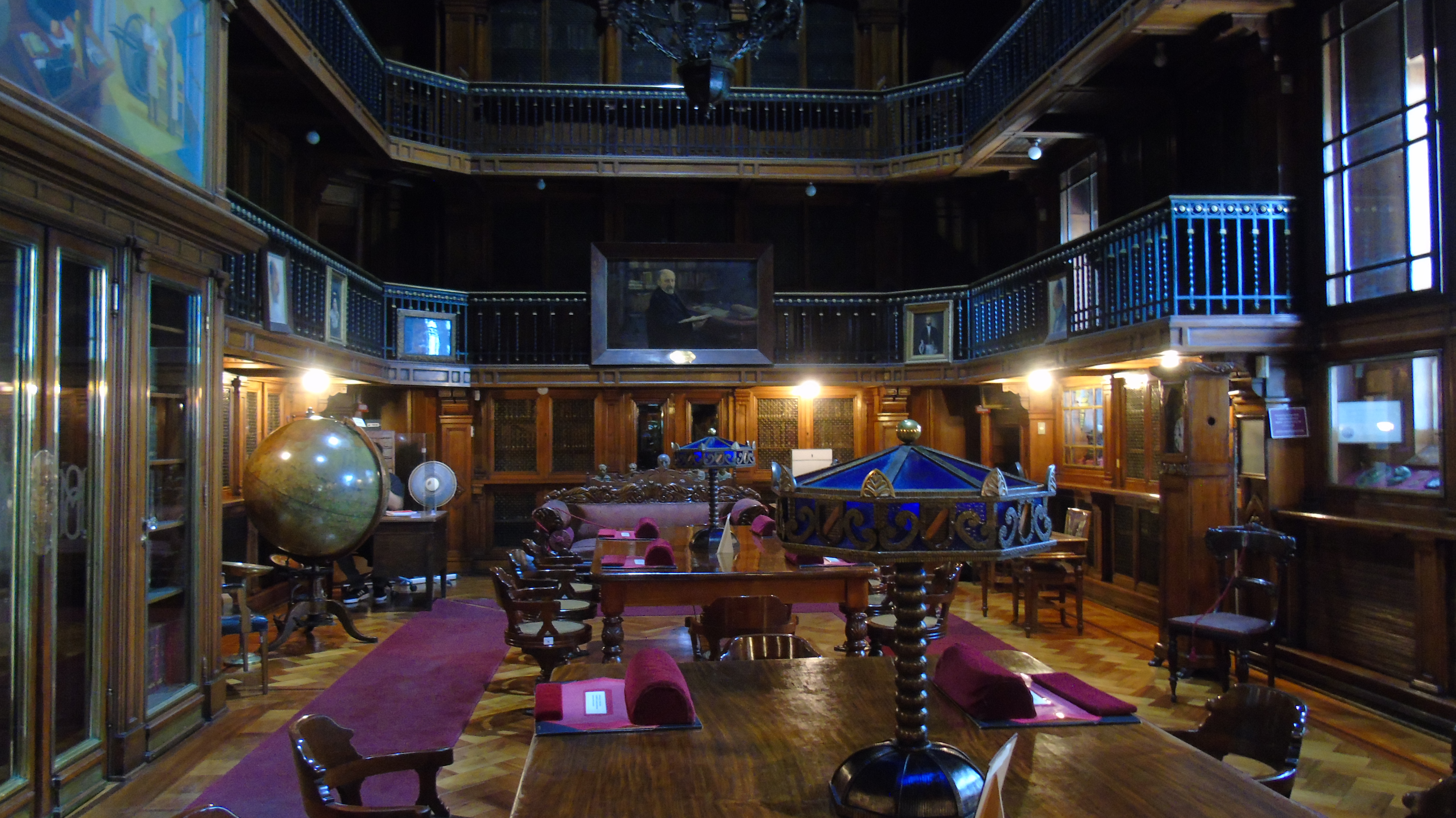
These cartographic materials arrived and were kept in his house, in the rooms adapted to gather his bibliographic collection. However, there are no textual references to this situation. A chronicle published in 1915 describes the rooms “filled with books [... ] piled up to the roof ” (Donoso, 1915, p. 47) without mentioning specific furniture for maps. The photographs included in this publication do not reveal the presence of maps in Medina’s house. A casual reference from 1926 to a map “within a frame” suggests that at least it may have been exhibited in one of those rooms before being deposited at the Library (Medina, 1926, II, p. 439).
That crowded house-library safeguarded Medina’s books and papers that were later handed to the National Library. The donation of Medina’s collection in 1925 imposed very detailed conditions (Rovira, 2002, p. 79; Sagredo, 2018b: pp. 50-52), including the provision to publish a catalog, which was prepared by Medina himself (Medina, 1926, I, p. xxiii).

Source: Donoso (1915, p. 37).
Figure 1 Photograph taken in 1915 of a corner in the library of Medina’s house (anonymous author). It illustrates the chronicle entitled “Talking with Don José Toribio Medina. Memories of his intellectual life.”
This was printed in 1926 in seven volumes. Medina conceived it as a “simple note” (Medina, 1926, I, p xi) intended for consulting the material. At the end of volume II, all the materials other than books are listed: Numismatics, Map Library, Stamps, and portraits. This list includes the other collections of Medina, including the collection of maps he had been gathering during his main activities as a bibliophile. Again, he resorted to the “map library” expression to identify this cartographic collection. This term now referred to the collection of maps he kept rather than the list of titles or his writings on geographic and cartographic history, which was the meaning he originally used in 1889.
About this “Map Library” section of the Catalog, he warned:
As for the map library, it clearly lacks annotations on the size of the maps, the scale depicted, and some other scientific detail; in this regard, the Colección de mapas, planos y vistas relativas a Chile (Collection of maps, drawings, and views relating to Chile) published in 1889, which, as a rule, mention these data, should be considered an integral part of this Section (Medina, 1926, I, p. xii).
Medina overlooked the fact that the list published in 1889 far exceeded his personal collection. And that, between the two dates, he had acquired other maps.6
Most importantly for our case, it made no mention of the fact that he had omitted some data when transferring the information from one catalog to the other in aspects other than the extension of each record.
Indeed, between 1889 and 1926, Medina modified what he considered his collection.
On the one hand, except for the atlases, he did not consider the maps contained in books, which ceased to appear as recognizable cartographic units. Two examples are the nine maps included in Alonso de Ovalle’s Histórica Relación del Reino de Chile (Historical Account of the Kingdom of Chile) in 1646 and Tomás López’s Mapa de una parte de Chile, que comprehende el terreno donde pasaron los famosos hechos entre españoles y araucanos, compuesto por el mapa manuscrito de Poncho Chileno“ (Map of a part of Chile covering the land that witnessed the famous events between Spaniards and Araucanos, composed of the manuscript map by Poncho Chileno”, included in the 1776 edition of La Araucana (Medina, 1889a, pp. 44-59). Given a choice, the maps contained in his book collection were no longer recorded as ancient maps, as preserving the integrity of the printed book was preferred.
The same logic led him to exclude from the new catalog the maps printed on the pages of periodicals such as Anuario Hidrográfico (Hydrographic Yearbook) and Anales de la Universidad de Chile (Annals of the University of Chile), which gave an account of the cartographic advances of Chile and were included in the 1889 listing. These were subsumed in the periodicals in which they had been printed and cataloged in a separate section. What was included were some of these maps when they had been printed separately.
Were these latter maps ancient, if they were printed in the late 19th century and the first years of the 20th? It seems that, in Medina’s view, they may become so and, in this sense, be included in the cartographic collection. Referring to a topographic and geological map of Chile produced by Amado Pissis at the request of the government, printed in 1870, Medina states:
It is easy to understand that a work of this nature is certainly neither complete nor can it be free of errors of some sort; however, as it stands, it can be considered the best of its class currently available for South America. The country and the government that supported its development and those who subsequently promoted it can be legitimately proud of it” (Medina, 1889a, p. CXXVI).
We understand that this approach implies that, sooner or later, these maps would stop being current, even those produced by scientists or technical bodies that Medina explicitly valued, so they were meant to enlarge the collection of ancient maps. We can guess, then, that Medina understood that to tell the geographic and cartographic history of Chile in the future, different maps would be necessary, including those that appeared then as the most recent, technically reliable, and updated, although their material conditions (simple prints with materials that did not seek to be eye-catching), did not make them objects of heritage value.
With the publication of his Essay, in 1889, Medina had undertaken a historiographic work, tracing the geographic and cartographic history of Chile from the maps he identified and was familiar with. That same historiographic work now opened up as a possibility by consolidating his collection of maps as part of the American Library at the National Library. The environment could not be more favorable: the inauguration of the new Library building as one of the milestones of the renewed investment in public works in Chile’s capital city.
In this regard, Guillermo Feliu Cruz, the first curator of the Medina Room, points out that “[the] bibliographer was born from here. Convinced that the literary history of America could not be established without a first recount, so to speak, of the intellectual production of the continent” (Feliu Cruz, 1933, p. 25). Similarly, as facts and testimonies of its time, the collection of maps would serve to trace a cartographic history of the country. Conceived as “cartographic documents” (Medina, 1924, p. 9), Medina studied them again when a Cartografía hispano-colonial de Chile (Spanish-colonial cartography of Chile) was published by the General Inspectorate of Geography of the Ministry of Industries and Public Works in two volumes. The first volume contained a “preliminary historical news” of each printed map, authored by Medina itself, while the second, as an atlas, reproduced maps of the Medina collection (except for one that belonged to the British Museum) (Greve, 1924, pp. 6-7). In this way, the ancient map, the collection, and the country’s history were unmistakably intertwined.
JOSE MARIA PRADO AND THE GEODESY ARCHIVE. FROM ARCHIVIST TO HISTORIAN OF ANCIENT MAPS
The Geodesy Archive houses more than 20,000 maps drawn at different scales, in various formats and with a range of references (Ministerio de Obras Públicas de la provincia de Buenos Aires,7 1945). It is one of the major cartographic repositories of Argentina.8 As an archive, its origin and scope were markedly different from the Medina collection. Its materialization was the result of a technical task that left a documentary repository. These materials were subjected to criteria that assigned them under the category of ancient maps. In some cases, this new status did not prevent the drawings from being used for solving issues related to territory ownership and features. In other words, the Geodesy Archive was not the result of the aim of gathering heritage maps but of the interest of those technicians who set out to revalue, from a historical perspective, some materials that had been accumulating.
Among these technical actors, the work of José Maria Prado (1896-2002) stands out, whose management resulted in the incorporation of the Department of Historical and Cartographic Research to the organization of the Directorate of Geodesy in 1985. Prado was born in Galicia, Spain. He migrated to Argentina with his family in 1896, and after completing his primary and high-school education, he started his career in the Province’s public administration. His joining the Archive was neither due to his qualifications nor to his interest in history or cartography, but was marked by the evolution of his work in the public administration. As a cadet in the Directorate of Schools of La Plata, he progressed to fulfill writer duties in the Ministry of Public Works of the Province. There, he had to dedicate himself to organizing the Archive at least once a day (Thill, 1994, p. 30). In 1931, he finally moved to the Archive Section of the Geodesy Directorate as an Auxiliary Archivist, a position he held until 1937, when he was promoted to Principal Archivist. Unlike Medina, Prado’s role lies within a framework of state expansion with a populist and redistributive orientation, which meant both the growth and the strengthening of the state apparatus. Although the Argentine State had started to consolidate its technical offices specialized in cartography since the early twentieth century during the period between wars, a consecration occurred that included the specialization and incorporation of technical bodies and the continuation of a policy that linked culture and nation.
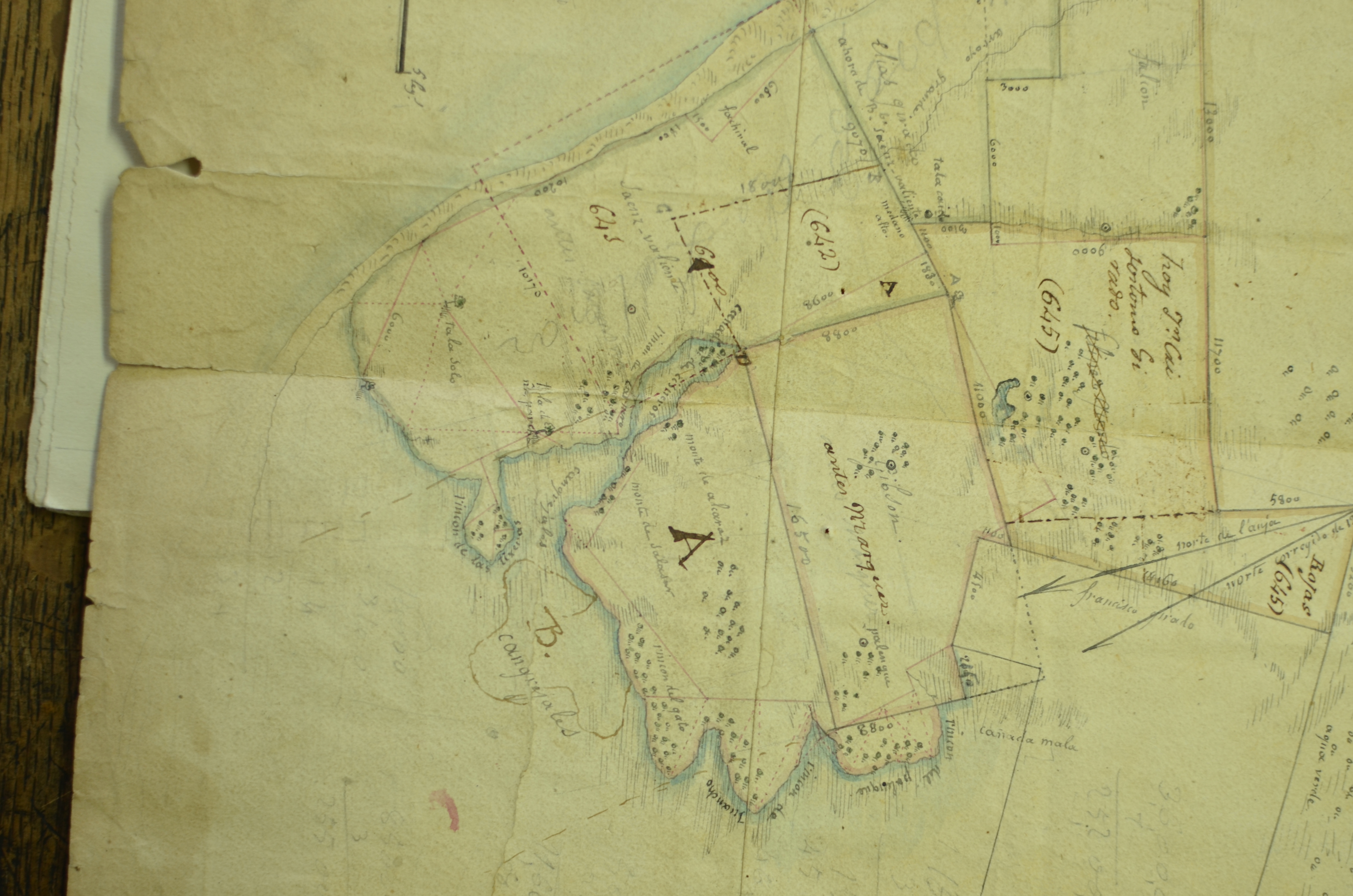
Source: Department of Historical and Cartographic Research of the Province of Buenos Aires.
Figure 4 Duplicate measurement by Jorge Gibson, recorded by Ambrosio Cramer, 1830 (Gral. Lavalle, Measurement 49).
When Prado was incorporated as an employee in the cartographic institution, he found materials from the Topographic Commission of 1824 that became the Topographic Department (DT)9 of the Province in 1826, with “a historical and regulatory repository to preserve all the drawings and statistical information used to make such cartography” (Dirección de Geodesia, Catastro y Tierras 1943, p. 6).
This repository is considered the beginning of the Archive (Direction of Geodesy, Cadastre y Tierras, 1943, p. 6)10 and was to be completed, among other things, with duplicates of the work of the surveyors. The rule remained in force — and when the DT was abolished in 1875 and replaced by the Department of Engineers (DI) — the figure of the Archivist was also contemplated. It was determined that its role was to “manage all the documents and drawings of the Department and provide any data requested by authorized experts in their professional work” (cited in DGCyT, 1943, p. 10). The Engineering Department was reorganized in 1890, and the Geodesy Section was split into two sub-directorates, one of which was named the Archive.
This technical Archive kept work material. It was built from the continuous work of the technical surveys on the field, according to the logic of the departmental division of the Province. The role of this Archivist technician was very important in the institution because the documentation he safeguarded was legally sensitive for involving land tenure. In fact, the only persons authorized to enter the Archive were the Archivist and the head of Topographic Drawing. According to a provision issued in 1858, they could not provide copies of documents either (DGCyT, 1943, p. 5).
How did the idea of an ancient map emerge in the Geodesy Archive? We believe measure recordings became obsolete as measurement methods evolved and the reality of land tenure changed. Still outdated, the measures were the background for the conduction of new measurements and made it possible to continue referring different legal instances to the territory. However, these materials clearly lost some of their technical functions while acquiring new ones when they started to be reviewed as testimonies of the past.
In 1937, a review of Prado was published in the Memoirs of the Ministry of Public Works, which praised the historical value of the materials safeguarded in the Archive he led:
not only interesting documentation kept on its shelves but, because of its origins going back to a distant time — almost dating back to the foundation of the Spanish colony by don Juan de Garay —, it is priceless for laying the grounds for historical or cadastral information (MOP, 1937, II, p. 65).
This condition had been enabled by significant institutional innovations: in 1928, the Geodesy Office’s Archive of duplicates opened to the public, and, in 1932, it was free. And it reached a peak when, in 1945, the Catálogo General de Mensuras de la Provincia de Buenos Aires (General Catalog of Measurements of the Province of Buenos Aires) was published, organized by subjects. In addition, it included an appendix called “Ancient measurements.” Although these did not correspond to the Province, Prado included them for considering them “elements of worth for historical research or studies on Mercedes that warrant going back to the origin” (Prado, 1945, p. iii). This section included the founding acts of the Topographic Commission of 1824 and the titles that enabled the first surveyors to conduct measurements in the territory of Buenos Aires.
The header of this section indicated that it contained
“Old measurements according to books 1 and 2 of the Topographic Department, corresponding to several areas of Province a, Santa Fe and Banda Oriental, submitted for registration to the Topographic Commission in 1824, whose location has been difficult for this work due to the lack of a map or because of inaccurate data,” (MOP, 1945, s/p).
According to this text, the designation as “old” was based on three elements: they were the books that inaugurated the measurement series; their date was before the creation of the Topographic Department; and they were characterized by lacking a precise location.
Although only the first two sections of the Archive were described as “ancient”, the whole catalog collection fitted this assignment. In fact, in the letter by Prado addressed to the Director of Geodesy and included at the beginning of the Catalog, he asserted that the work
“will have an immediate benefit to the professionals of Law 4048, the related national and provincial centers, and the guild, scientific and cultural associations and institutes of research and historical dissemination on the topography, toponymy, and first settlers of our once inhospitable and extensive pampa bonaerense (Buenos Aires plains” (Prado, 1945, P. iii).
Indeed, the Catalog would have a double function: it would bring technical benefits for professionals who were able to consult the measurements more easily and would allow for reconstructing the genealogy of that “pampa bonaerense”. By including these ancient documents, the Directorate started setting a cartographic tradition since it had clearly been one of the first institutions addressing cartographic matters in Argentina that measured and granted the authorization to do so.
In this dual function, the Archive continued receiving cartographic material. On the one hand, some new measurements were entered until at least the decade of 1960. Undoubtedly, the legal stability of the property and the smaller number of subdivisions contributed to limiting the production of new surveys11. On the other hand, explicitly obsolete materials were received — and therefore, conceived as old — by taking in the archives of retired surveyors who donated the works they had conducted throughout their professional life.12
The work of Prado should not be interpreted as an isolated case but is framed in a political context of state expansion and consolidation that implied, as mentioned above, the strengthening of technical knowledge, where the cartographic knowledge of Argentine was no exception. This strengthening involved the emergence of institutions and the organization of national scientific meetings that included different exhibitions of ancient maps in their agenda13. In fact, in parallel with Prado’s work, conferences were held involving specialists in cartographic matters. In these conferences, Prado played a marginal role, if at all.14 It was only in 1953, when the Second National Congress of Cartography was held in the city of Cordoba, that Prado participated among the representatives of the Archive.
Prado used various strategies to position the Archive as a historical source and position himself in relation to his work on these matters. In 1955, he organized the first of many cartographic exhibitions of the Archive. According to the account of anecdotes entitled “José Maria Prado. Su vida y su obra (His life and his work)”, on that occasion, the Jesuit Guillermo Furlong, a renowned specialist in ancient cartography, would have highlighted:
[The] magnificent display of cartography, with maps that had never been exhibited before (...). Not only for having displayed this cartographic treasure to the public for the first time, but for having rescued and preserved it from civil servants on duty, who, ignoring its relevance, abandoned everything in wet and gloomy warehouses, that is, as garbage, similar to the case of Federal Capital archives (cited in Thill, 1994, p. 35).
How true this was, we do not know for sure. In any case, we observe a certain positioning of Prado in the field of history and national cartography. In 1957, the Argentine Cartography Center (CAC) visited the Archive and launched efforts to establish the National Cartography Day, in commemoration of the creation of the Topographic Department. One year later, these links led him to organize the cartographic exhibition in La Plata within the framework of the III National Congress of Cartography.
In 1962, Prado published Documentos para la Historia del Departamiento Topográfico (Papers for the History of the Topographic Department). There, along with the CAC members, he proclaimed himself a pioneer of “a consciousness of Argentine Cartographic History” highlighting, in a heroic mood, the difficulties faced due to lack of space, furniture, and staff (Prado, 1962, p. I). These limitations were partially solved when the Archive was transferred to the new building of the Ministry of Public Works in 1960 and by the hiring of additional staff. There, the Archive maintained a sort of ordered disarray in which the location of items was subject to material limitations and was only known by Prado and his assistants.
The truth is that, at that time, the Archive had left its technical condition to become what Prado called “Historical Consultancy”. In 1971, the director of Geodesy issued a Provision that made the Consultancy official:
[Due to the] specific nature and the multiplicity of tasks in charge of the Department of Historical and Cartographic Research, it was essential to allocate additional personnel to those already exercising these functions, familiar with the study and selection of background information and documentation related to historical works, thus officializing in the structure of Distribution (Thill, 1994, p. 58).
Prado was appointed head of the Consultancy in 1974, a distinction that would make him a senior officer and a historian. Prado remained in office until 1984. A decade later, he donated all his personal collection to the Department of Historical and Cartographic Research without specifying what kind of materials were included in the donation or whether there were ancient cartographic records. The truth is that the keeping work made it possible to consolidate a collection of ancient maps. This characterization emerged as a contextual and flexible condition emanating from what was expected from the cartographic material rather than an intrinsic quality derived naturally from its date of elaboration. For several decades, in the Geodesy Archive, a measurement could or could not be an ancient map, depending on how it was used. This ductility ended up leaning toward the affirmation of the historical value of measurements, which served as testimonies of the continuous territorial history of both the Province and Argentina.
CONCLUSION
This article reconstructed the processes that resulted in the creation of two map libraries that involve different formation logics — archive and collection. Despite these differences, both map libraries share at least two common aspects: the unintentional and unplanned practice that gave rise to them and the close relationship between the valuation of the cartographic collection and the aim to recount a history of cartography and the territory.
Indeed, the collection of maps gathered by the Chilean scholar José Toribio Medina was consolidated through time as a byproduct of the work that captured the focus of this Americanist bibliophile, “with no intention of writing a book”, in his own words. In the case of José Maria Prado, his activities related to the maps of the Province of Buenos Aires were linked to his work as a public officer in charge of the documents of the Directorate of Geodesy. This work led him to carry out, little by little, over the years and, as he himself highlights, patient and modest studies on history and to seek the protection of the maps that told the history of the institution and the Province’s territory.
Medina gathered, kept privately, and then donated to the National Library of Chile the materials he treasured in his house-library, including his collection of maps. The catalogs of 1889 and 1926 show that the scope of the collection changed between the two dates, not so the idea that contemporary maps had a place in a collection of maps, nor the close relationship that Medina sought between the safeguarding and the value assigned to the cartographic collection and the possibility of constructing a historiographic narrative.
On the other hand, Prado sought a way to treasure cartographic objects with which he had daily contact in an institution that accumulated them and then left them in oblivion, as he wrote. To this end, he worked as a watchman and advertiser and produced the catalog that gathered the measurements and materials from 1826 to 1945 kept by the institution. His work was no less effective than Medina’s when he made these materials visible to narrate a past and justify their existence. In the long run, the historical Archive comprised not only the two sections of “Old measurements” identified in the 1945 catalog, but also the set of materials housed in the Geodesy Archive.
The collections studied are related to different political-ideological contexts: the one dealing with modernization in an oligarchic key in Chile at the turn of the century; and the one related to the redistributive and growth policies of the State apparatus of the period between wars, in Argentine’s case. However, both Medina’s collection and the Archive institutionalized by Prado are materializations of the same conceptualization of the ancient map, which stands out for its flexibility. We contend that this idea allowed for identifying, in a contextual and variable way, repertoires of different cartographic documents to which heritage value was attributed, using criteria that were far more complex than merely dating.
When designated as ancient, the cartographic material was subjected to various historiographical processes. These maps would be used to build genealogies of the national or provincial present by becoming a material imprint of past truths or ancient testimonies of lasting truths; or, by evidencing their obsolescence, introducing a critical distance from past events. As a result, they were recognized as having a patina that granted them renewed validity and legitimacy, regardless of their true characteristics. This conception even justified that besides the maps that had already acquired the ancient status, others could be added which, being contemporary, were bound to become obsolete through time. Contrary to what a heroic institutional account might suggest, we observed that, in both cases, the notion of cartographic heritage is an effect of working practices in dialog with the idea of an ancient map rather than a background assumption. Therefore, it constitutes a relevant analytical category for studying the history of cartography.
ABOUT AUTHORSHIP
The authorship of this article is arranged in alphabetical order. According to the rules of PLOS and the International Committee of Medical Journal Editors (ICMJE), the three authors participated in: 1. Conceptualization. Ideas, formulation, or evolution of the general research objectives and goals. 2. Formal analysis. Application of statistical, mathematical, computational, or other formal techniques to analyze or summarize study data. 3. Research. Conduct of the investigation and research process, specifically running experiments or data and evidence collection. 4. Writing - Original draft. Preparation, creation, or presentation of the published work, specifically the writing of the initial draft (including substantive translation). 5. Writing - Review and editing. Preparation, creation, or presentation of the published work by members of the original research group, specifically critical review, comment, or review. It is contemplated to include the stages before or after the publication.
ACKONOKWLEDMENTS
This article is the result from a joint collaboration by the authors on the collection of maps and the creation of map libraries, previously presented in the IX Ibero-American Symposium on the History of Cartography held in Lima in April 2022. We appreciate the comments received on the occasion of this presentation and the comments and suggestions of the reviewers who supported the current version of the text.
REFERENCES
Aliata, F. (2006). La ciudad regular. Arquitectura, programas e instituciones en el Buenos Aires posrevolucionario, 1821-1835. Buenos Aires: Prometeo-Universidad Nacional de Quilmes. [ Links ]
Anderson, B. (1993). Comunidades Imaginadas. Reflexiones sobre el origen y la difusión del nacionalismo. México D.F.: Fondo de Cultura Económica. [ Links ]
Baudrillard, J. (1969). El sistema de los objetos. México D.F.: Siglo XXI. [ Links ]
Biblioteca Nacional de Chile. (2006). Biblioteca Nacional de Chile: historia de las colecciones: Colección José Toribio Medina: 193 años de historia 1813-2006. Santiago: La Biblioteca. [ Links ]
Canedo, M. (2014). El ‘Restablecimiento’ del Departamento topográfico de Buenos Aires. Política y Gestión de un proyecto con consenso (1852-1857). Andes, 25(2). Recuperado en: https://www.redalyc.org/articulo.oa?id=12738569003. [ Links ]
Choay, F. (2007). Alegoría del patrimonio. Barcelona: Gustavo Gili. [ Links ]
Cook, T. (2010). Panoramas del pasado: archiveros, historiadores y combates por la memoria. Tábula, 13, 153-166. [ Links ]
D’ Agostino, V. (2014). Expansión estatal, política de tierras y desarrollo de la repartición topográfica en Buenos Aires, siglo XIX. Población & Sociedad, 21(2), 15-48. [ Links ]
D' Agostino, V. y Banzato, G. (2015). Funcionarios y políticas sobre el territorio en la Provincia de Buenos Aires: El Departamento de Ingenieros, 1875-1913. Decimoquinto Congreso de Historia de los Pueblos de la Provincia de Buenos Aires, 23 al 24 de abril de 2015, La Plata, Argentina. Recuperado en https://www.memoria.fahce.unlp.edu.ar/trab_eventos/ev.4113/ev.4113.pdf [ Links ]
Diccionario de la lengua castellana por la Real Academia Española, 1869, 1914 y 1992. Recuperado en Nuevo Tesoro Lexicográfico, https://apps.rae.es/ntlle/SrvltGUISalirNtlle. [ Links ]
Dirección de Geodesia, Catastro y Tierras. (1943). Guía de la Dirección de Geodesia. Antecedentes de la Repartición y Archivo. La Plata: La Dirección. [ Links ]
Donoso, A (1915). Conversando con Don José Toribio Medina. Recuerdos de su vida intelectual. Crónica y entrevista a Medina. Pacífico Magazine, s/n, 34-48. [ Links ]
Edney, M. (2005). Putting “Cartography” into the History of Cartography: A H. Robinson, David Woodward, and the Creation of a Discipline, Cartographic Perspectives, 51, 14-29. DOI: https://doi.org/10.14714/CP51.393 [ Links ]
Edney, M (2021). Origins of Map Libraries in the mid-Nineteenth Century. En: Mapping as Process. A blog on the study of mapping processes: production, circulation, and consumption. Recuperado de https://www.mappingasprocess.net/blog/2021/6/23/origins-of-map-libraries-in-the-mid- nineteenth-century. [ Links ]
Esteban, F. (1962). El Departamento Topográfico de la Provincia de Buenos Aires. Su creación y desarrollo. Buenos Aires: Dirección de Geodesia. [ Links ]
Favelukes, G. (2021). El plano de la ciudad: formas y culturas técnicas en la modernización temprana de Buenos Aires (1750-1870). Buenos Aires: Ediciones Digitales del Instituto de Arte Americano e Investigaciones Estéticas-Universidad de Buenos Aires. [ Links ]
Feliú Cruz, G. (1933). Medina y la historiografía americana. Un ensayo acerca de la aplicación del método. Santiago de Chile: Imprenta Universitaria. [ Links ]
Greve, E. (1924). Dos Palabras en J. T. Medina, Cartografía hispano-colonial de Chile: texto con noticias históricas (pp. 5-7). Santiago: Imprenta Universidad. [ Links ]
Harley, J. B. (1987). The Map and the Development of the History of Cartography en J. B. Harley y D. Woodward (eds.). The History of Cartography, I (pp. 1-42). Chicago: The University of Chicago Press. [ Links ]
Instituto Geográfico Militar. (1952). Memoria del Primer Congreso Nacional de Cartografía y de la 1° Exposición Nacional de Cartografía. Buenos Aires: El Instituto. [ Links ]
Lois, C. (2002). De desierto ignoto a territorio representado. Cartografía, Estado y Territorio en el Gran Chaco argentino (1866-1916). Buenos Aires: Instituto de Geografía, Facultad de Filosofía y Letras de la Universidad de Buenos Aires, Cuadernos Territorios 10. [ Links ]
Lois, C. (2014). Mapas para la nación. Episodios en la historia de la cartografía argentina. Buenos Aires: Editorial Biblos. [ Links ]
Lois, C. (2015a). El mapa, los mapas: Propuestas metodológicas para abordar la pluralidad y la inestabilidad de la imagen cartográfica. Geograficando. En Memoria Académica. Recuperado en: http://www.memoria.fahce.unlp.edu.ar/art_revistas/pr.6714/pr.6714.pdf. [ Links ]
Lois, C. (2015b). Un mapa para la nación argentina. Notas para una interpretación crítica de la historia del mapa político y de las políticas cartográficas. Huellas, 19, 193-215. [ Links ]
Martínez Sierra, R. (1975). El mapa de las pampas, Buenos Aires: EUDEBA. [ Links ]
McCracken, G. (1990). Culture and Consumption: New Approaches to the Symbolic Character of Consumer Goods and Activities. Indiana: Indiana University Press. [ Links ]
Medina, J.T. (1889a). Ensayo de una mapoteca chilena. Ó sea de una colección de los títulos de los mapas, planos y vistas relativos á Chile arreglados cronológicamente. Con una introducción histórica acerca de la geografía y cartografía del país. Santiago de Chile: Ercilla. [ Links ]
Medina, J.T. (1889b), Catálogo de la colección de mapas, planos y vistas relativos a Chile. Santiago de Chile: Impreso en casa del autor. [ Links ]
Medina, J.T. (1924). Cartografía hispano-colonial de Chile: texto con noticias históricas . Santiago: Imprenta Universidad . [ Links ]
Medina, J.T. (1926). Catálogo Breve De La Biblioteca Americana Que Obsequia J. T. Medina. Santiago de Chile, 1926. [ Links ]
Mendoza Vargas, H. (1993). El surgimiento del Estado de México y los trabajos cartográficos de Tomas Ramón del Moral, en V.M. Ruiz Naufal (dir.), Cartografía Histórica del Estado de México. Atlas General del Estado de México (pp. 91-140). Toluca: Gobierno del Estado de México. Secretaría de Finanzas/Instituto de Información e Investigación Geográfica y Catastral. [ Links ]
Mendoza Vargas, H. (comp.). (2000). México a través de los mapas. México D.F.: Plazas y Valdés /Instituto de Geografía, Universidad Nacional Autónoma de México. [ Links ]
Ministerio de Obras Públicas de la Provincia de Buenos Aires (1937). Memorias. Buenos Aires: El Ministerio. [ Links ]
Ministerio de Obras Públicas de la Provincia de Buenos Aires (1945), Catálogo General de Mensuras existentes en el Archivo de la repartición entre 1824 al 30 de junio de 1944. La Plata: El Ministerio. [ Links ]
Moncada Mayo, J. O. (2002). La construcción del territorio. La cartografía de México independiente, 1821-1910. En H. Mendoza Vargas, E. Ribera Carbó y P. Sunyer Martón (eds.), La integración del territorio en una idea de Estado. México y España (1820-1940). (pp.122-130). México D.F.: Universidad Nacional Autónoma de México/ Instituto Mora/ -Agencia Española de Cooperación Internacional. [ Links ]
Muñoz Arbeláez, S., Díaz Ángel, S. y Nieto Olarte, M. (2013). Desensamblando la nación. El caso del Atlas geográfico e histórico de Colombia de 1889. En O. Restrepo (ed.), Ensamblado en Colombia. Ensamblando Estados, vol. 1. (pp. 143-178). Bogotá: Universidad Nacional de Colombia. [ Links ]
Nadal, F. y Urteaga, L. (1990). Cartografía y Estado. Los mapas topográficos nacionales y la estadística en el siglo XIX. Geocrítica, 88. Recuperado de http://www.ub.edu/geocrit/geo88.htm. [ Links ]
Pesoa Marcilla, M. (2020). La necesidad de un mapa para la provincia. La institucionalización del conocimiento cartográfico y catastral durante el siglo XIX en la Provincia de Buenos Aires. Geograficando, 16(2). https://doi.org/10.24215/2346898Xe083 [ Links ]
Podgorny, I. (2011), Fronteras de papel: archivos, colecciones y la cuestión de límites en las naciones americanas. Historia Crítica, 44, 56-79. [ Links ]
Prado, J.M. (1945). Al señor Director de Geodesia, Catastro y Tierras, Ingeniero José Luis Burgueño, S/D. En Ministerio de Obras Públicas de la Provincia de Buenos Aires, Catálogo General de Mensuras existentes en el Archivo de la repartición entre 1824 al 30 de junio de 1944. (pp. III-IV). La Plata: El Ministerio . [ Links ]
Prado, J.M. (1962). Documentos para la Historia del Departamento Topográfico. Buenos Aires: Dirección de Geodesia . [ Links ]
Rovira, J. (2002). José Toribio Medina y su fundación literaria y bibliográfica del mundo colonial americano, Santiago de Chile: Dirección de Bibliotecas y Museos/Centro de Investigaciones Diego Barros Arana. [ Links ]
Sagredo, R. (2009). Geografía y nación. Claudio Gay y la primera representación cartográfica de Chile. Estudios Geográficos, LXX(266): 231-267. [ Links ]
Sagredo, R. (2018a). El futuro de Chile delineado en un mapa. Revista de Geografía Norte Grande, 69, 49-69. [ Links ]
Sagredo, R. (2018b). J. T. Medina y su Biblioteca Americana en el siglo XXI. Prácticas de un erudito. Santiago de Chile: Ediciones Biblioteca Nacional. [ Links ]
Sagredo, R. (2021). La Mapoteca Chilena de Medina, reflejo de un americanista. Ariadna Histórica. Lenguajes, conceptos, metáforas, 10, 225-254. Recuperado de https://ojs.ehu.eus/index.php/Ariadna/article/view/23281. [ Links ]
Subercaseaux, Bernardo (2011). Historia de las ideas y la cultura en Chile. Vol. II. Santiago: Editorial Univesitaria. [ Links ]
Thill, J.P. (1994). Anecdotario. En R.G. Correbo, J.P. Thill y J.M. Tonelli (eds.). José María Prado su vida y su obra (pp. 28-131). La Plata: Consejo Agrimensura de La Plata. [ Links ]
Vega, A. (2018). Mapotecas en Santiago de Chile: regímenes de visibilización del corpus cartográfico y sus mediaciones conceptuales y materiales. Revista de Geografía Norte Grande, (69), 71-97. Recuperado de https://dx.doi.org/10.4067/S0718-34022018000100071. [ Links ]
Zweifel, T (2021). Ordenar y dar a ver un archivo. El rol de Joé María Prado como director del Archivo de Geodesia en la Provincia de Buenos Aires (1931-1984). En C. Montaner y C. Lois (eds.). El mapa como elemento de conexión cultural entre America y Europa. Actas del 8º Simposio Iberoamericano de Historia de la Cartografía (pp. 102-107). Barcelona: Generalitat de Catalunya/Institut Cartográfic i Geológic de Catalunya. Recuperado de https://www.icgc.cat/bd/pubs/icgc_m_40_8_iberoamerica.pdf [ Links ]
1Patina as a materially incarnated status: something that is deposited on the surface of things that attests to its ancient condition, a sign of legitimacy. Similar to a Pierce icon, it is a sign that shows the imprint of what it means (Mc-Cracken, 1990).
2We use the term “map library” as a generic descriptor for a cartographic collection, including both cartographic collections and cartographic archives. Vega (2018) discussed the distinction between collection and archive and its relevance for the understanding of cartographic collections. The former responds to a collection of materials whose primary function is overshadowed by the criteria and circumstances that organize the collection of cartographic pieces; the second refers to the cartographic documentation produced by an agent in the exercise of its functions, which becomes filed evidence or documentary footprint.
3This work was the subject of a presentation by Alejandra Vega entitled “Medina y el Ensayo acerca de una mapoteca chilena (1889) (Medina and the Essay on a Chilean Map Library, 1889) at the 7th Symposium on Ibero-American History of Cartography held in Quito, Ecuador, in 2018. Tensiones en la articulación entre libro, mapa, historia y territorio en el siglo XIX” (Strains in the articulation between book, history and territory in the 19th century). Sagredo (2021) studies this presentation as an expression of the practices of Americanist scholars.
4Sagredo reconstructs the bibliophile practice of Medina in cultural history from the American Library and its bib- liographic and documentary collection, characterized as the main work of José Toribio Medina. His books were “the most eloquent outcome of his efforts, interests, research, and concerns as a historian, bibliographer and scholar” (Sagredo, 2018b, pp. 22-23 and 157).
5The sections are: “South America in general”, “Maps in which Chile appears along with other countries of South America”; “Chile proper”; “Western Patagonia - Strait of Magellanes - Tierra del Fuego” and “The Pacific Islands belonging to Chile”.
8In this country, the cartographic heritage is not deposited in a single institution. These collections include the Mitre Archive. with 2612 cartographic pieces; the General Archive of the Nation, with 1571 items; and the National Library, which houses 12 000 items (according to their respective website catalogs). On the other hand, provincial institutions such as the General Archives of the Provinces contain the documents of the Topographic Departments, such as the Entre Rios province.
9For the history of the DT of the province of Buenos Aires, refer to Esteban (1962); Martínez Sierra (1975); Aliata (2006); Canedo (2014); Favelukes (2021). About the later Department of Engineers, refer to D’Agostino (2014); D’ Agostino y Banzato (2015); Pesoa Marcilla (2020).
11In the online version of the catalog, the Department of Olavarria records measurements of 1948, 1952 and 1969, while the Party of Pilar records measurements corresponding to 1970.
13To note, these exhibitions were displayed around the concepts of “historical cartography” or “ancient cartography”, rather than the ancient map, at a time when these concepts still lacked a sufficiently precise profile.
14Examples are the first Argentine Conference of Cartographic Coordination held in 1936 and the first National Congress of Cartography and the first National Exhibition of Cartography in 1951, in which Prado was not part of the delegation of the Directorate of Geodesy (Military Geographic Institute, 1952, p. 8).
Received: October 13, 2022; Accepted: January 13, 2023; Published: March 03, 2023
 Este es un artículo publicado en acceso abierto bajo una licencia
Creative Commons
Este es un artículo publicado en acceso abierto bajo una licencia
Creative Commons
