


Services on Demand
Journal
Article
 text in
  English (pdf)
 Article in xml format
 Article references
 Send this article by e-mail
Indicators
-
 Cited by SciELO
 -
 Access statistics
Related links
-
 Similars in
SciELO
Similars in
SciELO
Share

 Permalink
Investigaciones geográficas
On-line version ISSN 2448-7279Print version ISSN 0188-4611
Invest. Geog n.108 Ciudad de México Aug. 2022 Epub Sep 12, 2022
https://doi.org/10.14350/rig.60490
Articles
The Territorial Organization of Nopal Pad production in Tlalnepantla, Morelos

* Facultad de Filosofía y Letras, Universidad Nacional Autónoma de México, Cto. Interior s/n, C.U., Coyoacán, 04510, Ciudad de México, CDMX, México. Email: aguilarsanchez.daniel@gmail.com
** Instituto de Geografía, Universidad Nacional Autónoma de México. Circuito Exterior, s/n, Ciudad Universitaria, CP 04510, Ciudad de México, CDMX, México. Email: mtss@geografia.unam.mx
The municipality of Tlalnepantla has evolved from an economic structure based on self-consumption agriculture and forestry to the extensive production of nopal (prickly pear) pads for national and international consumption. This shift has changed its primary economic sector and fostered a new territory organization around this activity. This research aims to analyze the territorial organization process of the production chain of nopal pads grown in this municipality and its main implications regarding its territory and the producers involved. The study involved a survey of the physical and historical factors that have influenced the evolution of this activity. Additionally, information was directly collected in the field through the experiences of different types of producers. This was supplemented by data collected from statistical and bibliographic information to conduct a cartographic analysis and summary of the current territorial organization of nopal pad production in the municipality of Tlalnepantla. The results of our research revealed that the territorial organization of nopal pad production is partly managed by local producers, which, in addition to its closeness to Mexico City, has benefited the production and commercial conditions. However, at the same time, it has resulted in the marginalization of another sector of nopal pad producers because of political factors and direct competition within the national market of this vegetable.
Keywords: territorial structure; territorial processes; production chain of the nopal pad; agricultural changes; commercial agriculture
El municipio de Tlalnepantla ha transitado de una estructura económica basada en la agricultura de autoconsumo y la actividad forestal hacia la producción, en grandes extensiones, de nopal verdura para consumo nacional e internacional. Con ello ha modificado su sector económico primario y ha propiciado una nueva organización de su territorio en torno a esta actividad. El objetivo de esta investigación es analizar el proceso de organización territorial de la cadena productiva del nopal verdura que se cultiva en este municipio y sus principales implicaciones tanto en su territorio como en los productores involucrados. Para ello, el trabajo se apoyó en un reconocimiento de los factores físicos e históricos que han impulsado el desarrollo de esta actividad y, posteriormente, se recopiló información directa en campo a través de las experiencias de diferentes tipos de productores, la cual se complementó con datos recopilados de fuentes de información estadística y hemerográfica, a fin de analizar y sintetizar cartográficamente la organización territorial actual de la producción de nopal verdura en el municipio de Tlalnepantla. Los resultados de la investigación revelaron que la organización territorial de esta actividad destaca por ser manejada en parte por los productores locales, lo que sumado a su cercanía a la capital del país, ha beneficiado sus condiciones productivas y comerciales, pero al mismo tiempo, ha derivado en la marginación de otro sector de productores de nopal como resultado de factores políticos y de la competencia directa en el mercado nacional.
Palabras clave: estructura territorial; procesos territoriales; cadena productiva; cambios agrícolas; agricultura comercial
INTRODUCTION
The prickly pear (hereafter nopal) cactus (Opuntia ficus-indica) is a plant that was domesticated sp,e 8000 years ago in central Mexico (Reyes, Aguirre and Hernández, 2005). It is currently grown in at least 26 countries as a result of its environmental and nutritional value and its resistance to drought, with over 3 million hectares planted worldwide (FAO, 2017).
In Mexico, the production volume for consumption as a vegetable has increased over the past decades,1 from 174 630 tons to 853 495 tons between 1990 and 2018, while its crop area grew from 6132 to 12 853 hectares. It is produced mainly in the states of Morelos, Mexico State, Puebla, and Hidalgo, and in Mexico City (SIAP, 2020). The volume of international exports of Mexican nopal pad doubled from 21 thousand to 45 thousand tons between 2010 and 2016, while its value tripled from four to 14 million dollars. It is currently grown in 26 countries (SIAP, 2017).
The municipality of Tlalnepantla, located in the state of Morelos, is the main producer of nopal pad at the national level, contributing about 33.5% to the country's production in 2018 (SIAP, 2020). This activity has given a new turn to the primary sector of this territory, formerly characterized by forest exploitation and subsistence agriculture. Today, nopal cultivation drives the socioeconomic dynamics of the municipality; for this reason, research has been carried out on this activity in the study area from different approaches. Freeman (2000) addressed the impact of globalization on agriculture in the municipality of Tlalnepantla from the anthropological perspective. Ramos (2011) explored the productive reorganization of the municipality and the role of the main social actors from the approach of local agri-food systems. Tovar (2010) analyzed nopal agriculture from the perspective of the territorial components and the impact of the organization of peasants and inhabitants as key elements in local development. Pérez and Salazar (2013) explored the influence of the community's intangible capitals as key elements for the development of the municipality. Finally, Ramirez (2018) investigated the pollution issues associated with agrochemicals in nopal production in Tlalnepantla and the challenges producers currently face in shifting their practices toward organic agriculture.
Although these studies have stressed that nopal pad production has boosted the economic development of Tlalnepantla, it has also revealed that the benefits have not been evenly distributed for all involved (Freeman, 2000; Ramos, 2011; Tovar, 2010). This is a symptom of a heterogeneous organization of this activity, in which not all the persons/sectors involved have the same conditions and means to foster their economic development.
To understand the root causes of these differences, we deemed it necessary to determine the process that has governed the territorial organization of nopal production. To this end, we addressed the processes that have led to the development of the current territorial structures, the spatial patterns adopted, and the main characteristics, needs, and interests of the stakeholders involved in nopal management. In this sense, the study of the territorial organization of the production chain of nopal pad produced in Tlalnepantla helps interpret how this activity is spatially organized and the reasons and consequences of it.
Based on the above, the central question addressed was: What are the main processes that have governed the organization of the nopal pad production chain in the municipality of Tlalnepantla and the elements and characteristics of the associated territorial structure? This work analyzed the processes that have influenced the organization of nopal agriculture in this area and the territorial structures that have shaped it.
Conceptual Framework and Methodology
The research was developed from the economic geography perspective, which explores the spatial arrangement of economic activities based on the analysis of the economic processes, the key agents, and the relationships between the economy and the territory that run its organization. Its objectives include the analysis of the causes and consequences of the inequalities derived from the formation of particular territorial structures resulting from the historical, social, cultural, and political dimensions of society (Méndez, 1997).
On the other hand, territorial organization is a concept that refers to the conditioning of space to meet the needs of society (Troitiño, 2006); it is transformed from the settlement of human groups and the various elements through which they carry out their activities (George, 2003). This concept provides the methodological basis for studying geographic-economic facts by interpreting how societies manage the territory (Aponte, 2010). Kostrowicki (1986) emphasized that territorial organization can be studied from the identification of its guiding principles: structure and territorial processes.
Source: Own elaboration based on Palamarchuk, Gorlenko, Privalovskaya, and Runova (1976); Boisier (1981); Kostrowicki (1986); Aguilar (1989); George (2003); Troitiño (2006).
Territorial processes are the intangible or abstract dimension that has guided the development of the structure, including its history, the needs and objectives of society, and the changes in the territory during its reconstruction, including the various events that shape the social dynamics and spatial organization of their activities (Kostrowicki, 1986). The analysis of territorial processes makes it possible to understand how the organization of the territory has been shaped during the evolution of society and the needs to which it responds.
The territorial structure includes the physical and tangible elements distributed in a given area, occupied by society and its activities. It involves the natural resources of the territory, human settlements and their characteristics (dimension, distribution, and social conditions), production activities and their territorial arrangement (infrastructure and spatial distribution), and the fluxes between these elements (Palamarchuk et al. 1976; Boisier, 1981; Aguilar, 1989). As a whole, the territorial structure seeks to meet the needs of society (Kostrowicki, 1986).
In the particular case of the organization of the rural territories, Schejtman and Berdegué (2003) have emphasized that the demand for food outside the rural territory directly influences the economic organization of these spaces, being a central element for their conservation and development. However, since the organization of rural areas also expresses the identity and purposes shared by the local population, it should be recognized that the territorial structure that supports agricultural activities is organized according to endogenous and exogenous territorial processes.
Since cities generate the greatest demand for food, the link between urban and rural areas is essential in the organization of the agricultural territory. In this relationship, proximity is key for establishing bonds between these two areas. The French economic geography has developed a series of proximity approaches, which understand the territory as a strategic economic, cultural, political, and social resource in urban-rural relations. Proximity is understood in two ways: spatial or geographical proximity, i.e., the physical distance between the areas of food production and consumption; and organizational proximity, understood as the number of stakeholders involved in production chains (Delgadillo, 2019).
Production chains involve the stakeholders and territories involved in good production and exchange processes; studying them requires a description of the structure of each link involved (inputs, production, marketing, and industrialization). In this sense, proximity approaches are essential in the analysis of production chains to understand the relationships between the stakeholders involved in the chain and analyze the efficiency in the distribution of the capital generated by these circuits.
On the other hand, the territorial organization of the production chains is not necessarily neutral for all the stakeholders since it is shaped by specific interests and objectives. Parnreiter (2018) emphasizes that the territorial organization of economic activities takes place in environments where control over activities or areas with the greatest capacity to produce economic benefits is constantly disputed. Therefore, the study of territorial organization cannot be limited to pointing out the territorial processes and structures that shape it but should also address the confrontation of interests and their influence on the territorial configuration of a given activity.
METHODOLOGY
We followed a qualitative methodology to address the research question from cabinet work supplemented with primary information obtained during fieldwork in Tlalnepantla from August 23 to 25, September 7 to 14, and October 11 to 13, 2019.
The territorial organization concept provides a methodological basis for exploring how societies manage their territory to perform economic activities. Since the territorial organization is built from historical facts and is supported by material structures allowing the development of human activities, its study requires analyzing its past and recognizing its current configuration. Accordingly, the methodology of the present investigation comprised the following phases:
Cabinet work: From statistical and geographic information of the municipality, the physical and socioeconomic conditions of the study area were characterized in general terms to identify the features of the municipal territorial structure that set the context for nopal production.
Cabinet work: The review of various official written sources and local information media revealed the agricultural history of the study area to identify the key processes in the current territorial organization of nopal pad production in this municipality. Based on this information, we reconstructed the evolution of this activity and the spatial patterns that remain in force.
-
Fieldwork in the local community to identify its territorial structure and functioning: The objective was to investigate the main characteristics and elements that make up the territorial structure of nopal production in Tlalnepantla through interviews with 25 nopal farmers. The data collection techniques used were field observation, interviews, and recording geographic coordinates. Sampling for interviews was conducted using the snowball technique, which consists of initial contact with subjects who share several distinctive features with other individuals. To reduce to some extent the bias involved in this sampling technique, nopal production was not the only feature of interest considered; we also contemplated the participation of farmers in organized groups of producers and their place of residence.
From the above, we collected information on physical elements (places, infrastructure, services, stakeholders involved, and flows of goods or persons across the territory) involved in the organization of the activity. The main features identified were the linkages with other producers, the destination of production, the distribution of nopal crops, the main retail outlets, industrial projects, and the use of inputs.
Mapping and graphic representation of the information obtained: We used the software QGIS version 3.4.4. and database files of the 2018 geostatistical framework of the Instituto Nacional de Estadística y Geografía (Mexico’s National Institute of Statistics and Geography; INEGI, for its acronym in Spanish) for the delimitation of administrative units (municipalities and states) and the 2018 National Road Network to construct maps and figures displaying the key elements in the territorial organization of nopal pad production in Tlalnepantla. The rest of the layers were built from the information obtained in the field. The results were discussed from the treatment of the information obtained.
RESULTS AND DISCUSSION
Geographic Characteristics of the Study Area
The Tlalnepantla municipality is located in the north of the state of Morelos (Figure 2), comprising an area of 124 km² and consisting of four main localities and fractionated land (Figure 3). It maintains regional links with Mexico City, particularly with the Milpa Alta municipality, leveraging its proximity to the country's capital city to market agricultural products. Its main communication road is the Mexico-Oaxtepec section of Federal Highway No. 113, which connects each locality with the country's capital and the interior of Morelos, facilitating the flow of goods.

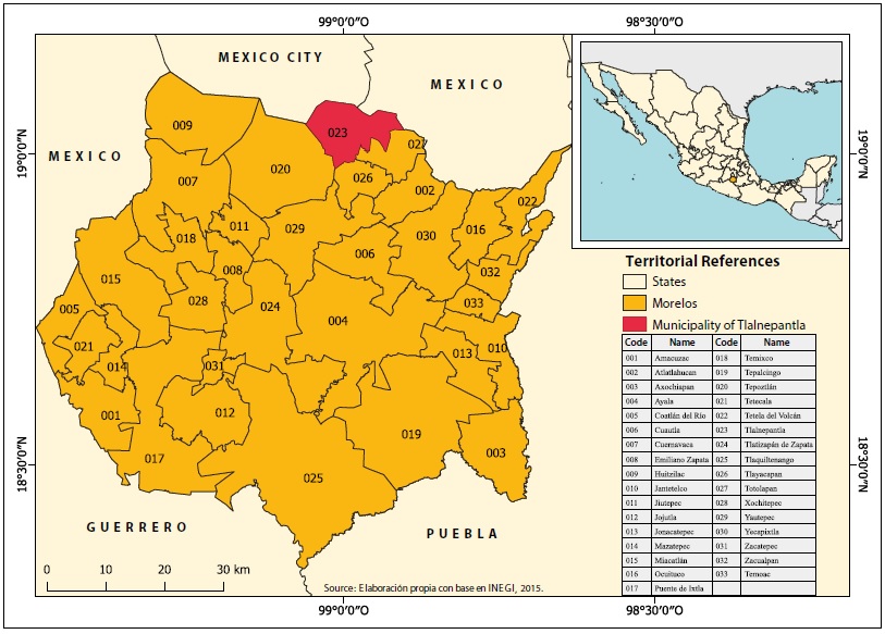
Source: Own elaboration based on INEGI (2015).
Figure 2 Location of the Tlalnepantla municipality, Morelos.

The proximity of Tlalnepantla to Milpa Alta, with which it shares a series of cultural ties established through family relations and population movements between the two areas, led to the establishment of nopal crops.
Nopal agriculture in this territory has been developed because of the physical features of the municipality, which have favored its adaptation and subsequent expansion. The relief of Tlalnepantla is mainly flat and semi-flat (84%) (INAFED, s.f.), while the nopal cactus can grow in areas with even steeper slopes (>5%) as well as in warm and dry environments (Centro del Nopal y Tuna del Estado de México, 1981). In addition, the soil types in the municipality are mostly suitable for the nopal pad production (Andosol, Feozem, and Lithosol) (INIFAP-CONABIO, 1995), which favors high production yields.
On the other hand, the climate of Tlalnepantla is semi-humid, with a mean annual precipitation of 2341 mm (Garcia and CONABIO, 1998), which can influence the high production volume in the municipality. However, excess water for a plant adapted to dry environments may involve a high use of agrochemicals to mitigate pests or diseases caused by the high volume of water available.
Tlalnepantla is a rural municipality with a total population of 7166 inhabitants (INEGI, 2015), a condition that, according to Gutiérrez de MacGregor and Gonzalez (2001), is reflected in a lag in their living conditions. However, these have improved between 1990 and 2015. For example, the average education level increased from 5.3 to 7.7 years, and illiteracy dropped from 13% to 7% (INEGI, 1990; 2015). Housing conditions also improved gradually, although the lack of piped water in more than half of the households, high overcrowding levels, and the high percentage of the employed population earning less than two minimum wages made Tlalnepantla the only Morelos municipality classified as highly marginalized in 2015 (CONAPO, 2016).
The municipality stands out for being primarily oriented toward the primary sector of the economy. In 2015, almost 70% of the employed population worked in production activities and, according to Pérez and Salazar (2013), about 90% of the inhabitants were linked to nopal pad production. On the other hand, 83% of the land in the municipality is socially owned: 33.1% ejidal and 50.2% communal (INEGI, 2007).
Historically, land ownership in Tlalnepantla has been mostly communal; Ávila (2001) highlighted that in the late nineteenth century (Porfirio Dìaz's ruling), the state of Morelos's territory consisted of haciendas (>50%), small property (25%), and mostly communal mountains in the rest of the area. The latter, where Tlalnepantla is located, lacked large haciendas, and most of the land was communal property; later, the agrarian reform from the Mexican Revolution slightly reshaped land ownership. The Coatepec hacienda (an area that currently harbors the San Felipe Neri town) was looted, burned, and abandoned, remaining under the custody of its workers, to whom the land was subsequently distributed to work (H. Ayuntamiento Municipal de Tlalnepantla Morelos, 2014).
In theory, land under social ownership is intended to work the land for the benefit of the community that owns it and set the grounds for the cooperation of peasants as members of the same community (Chacón, 2014). This scheme has been leveraged in Tlalnepantla, where peasants have collectively organized themselves to produce oat, nopal pad, and avocado (Ramos and Torres, 2014). Thus, the social property scheme has been perpetuated through land use for the benefit of the community, which has prevented cropland abandonment.
Outline of Agriculture and Nopal Production in Tlalnepantla, Morelos
From pre-Columbian times to the last decade of the 20th century, the economic and agricultural structure of the municipality remained with few in-depth changes. Since the emergence of the first settlements in the area currently occupied by the Tlalnepantla municipality, agriculture included mostly maize, chile, beans, and squash, supplemented by forestry. During the colonial period, given the climatic and orographic conditions in northern Morelos, the intensive sugar cane production that characterizes the rest of Morelos did not occur in Tlalnepantla; instead, this area supplied fuelwood and labor for sugar cane agriculture practiced in other areas of the state. Self-consumption agriculture was conducted in the area to produce basic crops and others from Spain (Avila, 2001). Tomato was the only crop incorporated into the local agriculture since 1930, which became important in the local economy for the high value of the harvest and its growing demand in Mexico City (Guzmán and León, 2009).
Tlalnepantla's role as an area that supplied forest products was maintained until the end of the 20th century. Then, the "Chichinautzin Biological Corridor" was formed by a presidential decree in 1988, covering part of the municipal territory (Ramos, 2010). In addition, tomato production started declining due to the competition with tomato production from Sinaloa (Guzmán and León, 2009). The impossibility of continuing exploiting forest resources and the issues related to tomato production forced the population to engage in a different activity, i.e., nopal cactus production.
The nopal cactus was introduced in Tlalnepantla from Milpa Alta through the family bonds between the population living in both areas; it spread steadily across the municipality in parallel with the reduction of areas used for growing maize, beans, oat, tomato, and wheat (Ramos, 2010). Areas dedicated to nopal cactus crops increased from 39% to 69% of the total municipal area between 2003 and 2018; the value of pod production rose from 63% to 89%. For its part, the municipal area dedicated to cereal production dropped from 41% in 2003 to 20% in 2018 (SIAP, 2020), the extent of tomato production underwent an 80% decrease between 1998 and 2018, and they are for peach production decreased by 92% over the same period (INEGI, 1999; SIAP, 2020).
The above data illustrate the expansion achieved by the nopal monoculture in the Tlalnepantla municipality, becoming the predominant economic activity that governs much of the local social dynamics. However, this activity has given rise to social conflicts among nopal producers over access to better production and marketing conditions.
The most emblematic conflict occurred in 2003 during the electoral process to elect the municipal president. According to the Standing Committee of the LIX Legislature (2004), the main reason was the confrontation of economic interests and the dispute over controlling the sales of nopal pads produced in the municipality. The candidates involved represented different groups of nopal producers, so winning the electoral contest meant gaining control of nopal production. This conflict gave rise to the creation of two groups of nopal producers with their own production and marketing processes (Ramos and Torres, 2014), which has had major consequences on the territorial organization of this activity.
After this event, the territorial structure of this activity has continued to evolve. Aspects worth highlighting include the development of agro-industrial projects to process raw nopal; the conversion of new agricultural spaces to nopal pad production; and the recent recognition of nopal as a staple and strategic product in article 42 of the Law on Sustainable Rural Development of the State of Morelos, an action expected to boost the allocation of public resources for improving production conditions and expanding nopal pad export markets (Tapia, 2019).
Analysis of the Territorial Structure of Nopal Production Activities
The brief historical synthesis of Tlalnepantla's economy identifies the processes that have shaped its current nopal pad production, creating the structure that defines the territorial organization of its production chain.
The establishment of the Chichinautzin biological corridor and the geographic proximity between Tlalnepantla and Mexico City are two factors that directly boosted nopal pad production in this area. The first factor translated into lower income from forest exploitation and the need to reorganize the economic sector. The proximity between Tlalnepantla and Mexico City was pivotal for expanding nopal agriculture in the municipality. Indeed, part of its production volume is marketed in the Valley of Mexico Metropolitan Zone (ZMVM, for its acronym in Spanish), ensuring a continuous demand for this product. On the other hand, the current expansion of this vegetable product has only been possible thanks to the physical-geographic features of this area. Both characteristics have been key to establishing a large part of the nopal pad production chain in the Tlalnepantla municipality.
However, despite being an activity that occupies about 70% of the crop area in the municipality, the territorial structure of nopal pad production is highly concentrated in the areas surrounding the municipal capital (the town of Tlalnepantla, Figure 4). The distribution of nopal production has derived from a characteristic historical feature of this area, i.e., its highly concentrated population in the municipal city. Between 1990 and 2010, 80% of the population settled in the municipal capital (INEGI, 1990; 2010), which resulted in the spatial heterogeneity in the availability of labor and potential nopal pad producers in the municipality by replicating the pattern of spatial concentration of nopal plots and their production and marketing structure. Thus, these plots are not evenly distributed throughout the municipality but are concentrated mainly in the central and southern zones, around the municipal capital, and even in areas classified as forest use, while nopal crops are less abundant to the north and west of the municipality.

Source: Own elaboration based on fieldwork, Google Earth, and Ramos (2011).
Figure 4 Territorial structure of the nopal production chain in Tlalnepantla.
On the other hand, the organization of the local inhabitants is one of the cultural features of the territory, which has been more accentuated in the municipality capital. At different times, the Tlalnepantla inhabitants have been organized to address security issues, use of forest resources, and negotiations with external economic stakeholders. This organization approach has also been adopted by nopal producers, who have formed groups incorporating key elements in the organization of nopal production in this area.
However, the expansion of nopal crops and market saturation led to new disputes among nopal producers seeking to improve their production and marketing conditions. Such was the case of the 2003 political conflict mentioned above, in which the control of nopal production activity was disputed. As noted above, this incident had a major impact on the territorial organization of nopal production - the first link in the production chain - and on the formation of different producer groups (i.e., organized and "excluded"), the differences of which are reflected in the rest of the links in that chain.
Figure 4 shows organized producers as those associated in groups, some of which regulate the access to a part of the production chain structure (mainly points of sale) through a set of rules. In 2003, they decided to support Conrado Pacheco as municipal president in a community meeting (not formalized through the electoral process). The so-called excluded producers are those who supported the PRI candidate, Elías Osorio, who won the elections and was subsequently dismissed for acts of violence against the opposition group. This organized group perceived his appointment as a violation of the decision made by the community assembly, leading to a series of sanctions against the group of producers that supported him. For their part, “free” producers are those who did not align with any candidate and were not sanctioned when the conflict ended.
The three types of producers - organized, excluded, and free - have marked differences in how their activities are organized, including the use of inputs for production, the location of their retail outlets, and their participation in collective projects such as the industrialization of nopal pads. They also show differences in spatial distribution, with free producers usually located outside the municipal capital and excluded and organized producers congregated in the center of the municipality.
Part of the territorial structure of nopal production activities has been built to a greater or lesser extent through government actions and the joint work of government agencies with local producers. Specifically, the construction of the road infrastructure in the municipality has facilitated the connection between nopal plots and destination markets. The road section connecting the town of Tlalnepantla with Mexico City is strategic for the circulation of trucks collecting and distributing nopal pads across Morelos and the rest of the country. In addition, the main collection centers and sales points for this product are located on roadsides (Figure 4), and some producers are installed along this road to sell their nopal.
An additional factor is road infrastructure development in the municipality connecting nopal plots with distribution sites, which displays a radial arrangement centered on the municipal capital and the nopal collection center located at its periphery. Some 4 million pesos of federal resources were invested between 2018 and 2019 in paving municipal roads (Transparencia Presupuestaria, 2020).
With the expansion of the nopal production activities, Tlalnepantla has become an attraction pole for temporary migrants, who arrive from the interior of Morelos and states such as Guerrero and Oaxaca to work as laborers in nopal production plots to support plant care and pad harvest. Likewise, the marketing structure linked to these activities has stretched beyond the municipal borders, involving the Mexico City's Produce Distribution Center (Central de Abastos; CEDA, for its acronym in Spanish), to which only a part of the producers have direct access to sell their products to buyers who visit this key produce distribution center every day.
With regard to the agricultural process, the use of agrochemicals and other inputs for nopal production increased as a result of the loss of soil fertility and the need to produce larger quantities of nopal. As a result, several businesses have been established to sell these inputs, which are also concentrated in the municipal capital. Six of the eight businesses supplying agricultural inputs and services are located in the municipal capital, and the remaining two are located in the locality of El Vigia. The most important of these businesses is the Casa de Insumos de Tlalnepantla (Tlalnepantla Supplies House), where farmers can purchase agrochemicals at discount prices because the municipal government directly participates in the supply of these inputs.
Another example of the centralization of supplies for nopal pad production is the distribution of federal resources for the primary sector in the municipality. In 2008, 87% of the 3 million pesos of federal resources allocated for Tlalnepantla crops went to different aspects of vegetable nopal production, such as hiring advisory services and applying technology to crop production. This amount was distributed in 37 systems that support nopal producers, 27 of which were concentrated on productive projects located in the municipal capital - eight in El Vigía and two in Felipe Neri (Transparencia Presupuestaria, 2009).
The economic and organizational differences between nopal producers are reflected in the contrasts in the use of inputs and the allocation of government resources. Seventy-six percent of those interviewed during fieldwork used agrochemicals in their plots, 68% received advisory to improve cultivation practices, and 56% used the so-called “motocultor” (a machine used to crush nopal pads and reincorporate them into the soil as organic manure); 40% of the respondents used all three types of inputs and machinery. As shown in Figure 3, the three types of inputs and machinery are used more extensively by organized producers and in crops around the municipal capital, while the rest of the producers use them less frequently. In this regard, we detected that some producers are not satisfied with how government resources for nopal production are allocated. Some contend that these allowances are granted“only to those [producers] in the municipality (municipal capital) or to “friends[of government authorities] and not to the poorest nopal farmers, who are affected and not left to work in peace”(statements recorded on September 13, 2019, in the localities El Vigía and Tlalnepantla, respectively).
Conflicts of this sort are also replicated across the marketing link of the production chain. One of the main sanctions imposed on nopal producers excluded after the 2003 conflict is the suspension of their rights to market their crops in the municipal distribution centers and Mexico City’s CEDA.
Organized farmers sell their produce in the municipal distribution centers, and some also sell them at CEDA (some within and others outside CEDA's facilities). Free producers have access to the municipal distribution centers but not to CEDA, while excluded nopal producers are not allowed to sell their produce at any of these sites. Consequently, they regularly do so in roadside stalls located along the Mexico-Oaxtepec highway or at their own plot, which involves a higher uncertainty regarding sales prices, so nopal pad is usually sold at a lower price than in the other distribution centers.
Access to better retail outlets is key to ensuring profitability, especially in a highly competitive context. Generally, the best nopal selling prices are found inside the CEDA and vary according to the season, ranging from 30 to 200 pesos per hundred pads; only some organized producers have access to this facility. Selling nopal pads in sidewalk stalls outside of the CEDA facilities also yields profits but involves several inconveniences, such as fixed sales hours and increased vulnerability to bad weather, which may affect sales price to as much as one-half the price inside the CEDA. Consequently, some producers allowed to sell their products outside the CEDA have opted to do so in the municipal distribution centers, where the price paid for the product is lower but is unaffected by the conditions mentioned above. Nopal price fluctuates broadly throughout the year, ranging from 20 to 300 pesos per box, which usually contains more than 200 pads. Producers selling nopal pads in stalls placed on roadside stalls or their plots aim to offer their products at the same price as in the Tlalnepantla distribution center but usually have to lower their prices by as much as 50% to encourage buyers to purchase their product.
The establishment of these barriers to gain access to part of the nopal marketing structure exemplifies the consolidation of strategies set to control key areas and processes that have been disputed within the community, where the interests of different stakeholders seeking to meet specific needs are confronted. This has brought about unequal economic benefits and development among the producers involved.
On the other hand, the nopal pad retail outlets are related to the geographic target (Figure 5). In 2019, nopal pads produced in Tlalnepantla were distributed to at least thirteen states across the country and abroad. According to the Board of Agricultural Development of the state of Morelos (Sedagro, for its acronym in Spanish), at least 70% of Tlalnepantla's nopal pad was marketed outside the state of Morelos (Zona Centro Noticias, 2015).

Source: Own elaboration based on fieldwork and Gobierno de Morelos (2020).
Figure 5 Target markets for nopal pad produced in the municipality of Tlalnepantla.
Despite the diversity of target markets and conditions in which each producer sells its crop, most marketing networks involve intermediaries as a means of access to the final consumer. Within the state of Morelos, producers transport nopal pads to the local markets, where buyers are mostly the end consumers. As the distance between the production areas and end consumers increases, the broad participation of intermediaries reduces the proximity between producers and consumers, affecting the profits of the former. As a consequence, most of the economic value from nopal pad sales is concentrated outside production areas. For example, an average of 15% of the value generated by Tlalnepantla's nopal pad production ended up in the hands of producers, while 85% was distributed among the wholesale and retail intermediaries involved (SIAP, 2020b).
On the other hand, the overseas marketing of nopal pads faces different issues. The most important is the content in nopal pads from Morelos of chemicals not allowed on international markets; the Food and Drug Administration has already detected this in the product exported to the United States (Ramirez, 2018). The coordinator of the Programa de Inocuidad Agrícola del Comité Estatal de Sanidad Vegetal del Estado de Morelos, A.C. (Agricultural Safety Program of the State Committee on Plant Health of the State of Morelos), Eduardo Martinez Tenango, has acknowledged that the nopal production has faced compliance issues regarding the quality standards demanded by international markets (Ruiz, 2019a). For his part, the municipal president of Tlalnepantla (2018-2021) stated that the probability of exporting this product was extremely low given the lack of health certificates required (Ruiz, 2019b).
Exports of nopal pad have declined gradually. From November 2002 to March 2003, 440 tons of nopal pads were exported (Pérez, 2003). Later, in 2014, according to Sedagro, 323 tons of nopal from Morelos were exported (El Regional, 2015); by 2019, Sedagro reported that exports of nopal pad reached only six tons (Gobierno de Morelos, 2020).
Since phytosanitary standards regulate the export of food products, government authorities have insisted on improving the production conditions of nopal cactus through safety programs, good agrochemical use and management practices, and organic production. In fact, local Morelos deputies and SEDAGRO officers have prepared initiatives to increase the possibility of exporting nopal pads from Morelos to international markets (Bacaz, 2019). However, according to Ramirez (2018), implementing these practices requires producers to own plots of at least three hectares for the activity to be profitable. This contrasts with reality, as the average nopal plot size reported by INEGI (2016) was 2.3 hectares, an area that varies widely depending on the case; for example, the size of nopal plots in the sample considered during fieldwork ranged between 0.5 and 6 hectares per producer.
Finally, in Tlalnepantla, several industrialization projects have been developed to transform nopal pads into a product with added value --seeking an alternative route to the saturated marketing circuits. Two agro-industrial projects led by the same nopal producers have been developed. Nopimor is managed by some producer families who own an industrial plant that started operating in 2019 in San Felipe Neri, a location that contrasts with the typical spatial concentration of the activity. Nochtlimex is a company created from the alliance between the state government and 375 organized nopal producers of Tlalnepantla, with facilities inaugurated in 2010. It has operated irregularly thereafter because of constant disputes within its organization and with potential buyers, which have hampered its development and consolidation (Expreso de Morelos, 2011).
Given the conditions of both projects, their social-territorial effects in Tlalnepantla are still slight, processing a small volume of nopal (Nopimor uses approximately 15 hectares of nopal production while Nochtlimex operations are currently suspended). However, both companies represent potential territorial transformation elements to the extent that they integrate larger nopal plots and consolidate their marketing links.
The territorial organization of this activity is schematically shown in Figure 5, displaying the main territorial processes shaping the various elements of the nopal pad production chain. Some features are initially similar for all producers involved, such as physical conditions and road infrastructure, but there are also specific processes that have resulted in multiple circuits due to the characteristics of the different producers and their conditions.
Not all producers are integrated into the chain under similar conditions, which determines the outcome of their activity. These differences affect the territorial organization of this activity, as shown in Figures 4 and 6, highlighting the creation of particular links and unique characteristics within the crowded territorial structure of the nopal production activity in Tlalnepantla.
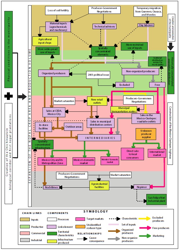
Source: Own elaboration based on fieldwork.
Figure 6 Territorial organization of the nopal pad production chain in Tlalnepantla.
Within this heterogeneity, there is a higher complexity in the networks of organized producers, who have greater access to different types of inputs, more marketing channels, and projects that supplement the sales of raw nopal. Moreover, the nopal production chain in Tlalnepantla has been organized territorially largely based on the objectives of this producer group in collaboration with different government levels.
The institutional linkages established and other actions undertaken by nopal production stakeholders have enabled organizational processes to face the power relations that marginalize the most disadvantaged groups of agricultural producers. However, new exclusion patterns have been replicated and affected these producers, reflected in the differences in their links and the issues they face relative to those of the most favored producers.
CONCLUSIONS
The territorial organization of nopal cactus agriculture in the Tlalnepantla municipality has been built based on endogenous attributes and processes, such as physical-geographic conditions and social dynamics. On the other hand, the proximity to Mexico City has been equally decisive in the establishment of nopal agriculture at different times of its development.
As nopal production is an activity governed by social production, its territorial organization has resulted from the objectives and needs of nopal producers, which are reflected territorially in the construction of infrastructure that has improved the production and marketing conditions. The organized nopal producers based mainly in Tlalnepantla have better access to the key structures of the nopal pad production chain. In addition, they have established a set of rules for accessing this chain, resulting in the emergence and replication of inequality and exclusion patterns affecting a segment of producers.
REFERENCES
Aguilar, A. (1989). Las Bases del Ordenamiento Territorial. Algunas Evidencias de la Experiencia Cubana. Revista Geográfica, 109, 87-111. [ Links ]
Aponte, M. (2010). Organización espacial de la región geográfica de la Alta Guajira colombiana. Perspectiva Geográfica, 15, 157-176. [ Links ]
Ávila, H. (2001). La agricultura y la industria en la estructuración territorial de Morelos. Morelos, México: UNAM-CRIM. [ Links ]
Bacaz, V. (2019, 11 de marzo). Morelos busca «plan B» para exportar nopal a otros países. El Financiero. Recuperado el 8 de julio de 2019 de https://cutt.ly/hRJyNJt [ Links ]
Boisier, S. (1981). La planificación del desarrollo regional en América Latina. En Experiencias de planificación regional en América Latina (pp. 21-66). Santiago: NU, CEPAL, ILPES y SIAP. [ Links ]
Centro del Nopal y Tuna del Estado de México. (1981). Perspectivas de la utilización del nopal y la tuna. México, DF: SAIMEX. [ Links ]
Chacón, D. (2014). La propiedad social en México ¿vuelta a la función social para resolver la crisis del agro? Estudios Agrarios, 55-56, 71-86. Recuperado el 23 de octubre de 2020 de https://cutt.ly/VmSbTBt [ Links ]
Comisión Permanente de la LIX Legislatura. (2004, enero 4). Informe sobre el conflicto en Tlalnepantla, Morelos. Recuperado el 23 de junio de https://cutt.ly/4mSQuUY [ Links ]
CONAPO. (2016). Índice de marginación por entidad federativa y municipio 2015. Recuperado el 22 de junio de 2020 de https://cutt.ly/ImFQV7c [ Links ]
Delgadillo, J. (2019). Producción y consumo en áreas metropolitanas. Una aproximación tipológica desde el enfoque de proximidad. Estudios Sociales, 29(53), 2-32. [ Links ]
El Regional. (2015, 15 de junio). Campesinos de Morelos exportan con éxito producción agrícola. Recuperado el 21 de julio de 2019 de https://cutt.ly/wmFcIp0 [ Links ]
Expreso de Morelos. (2011, junio). Detenida Comercialización del Nopal, dice Comité de Nopaleros de Tlalnepantla. Recuperado el 18 de mayo de 2020 de https://cutt.ly/ImFn7A6 [ Links ]
FAO. (2017). Es hora de poner cactus en el menú. Food and Agriculture Organization of the United Nations. Recuperado el 29 de mayo de 2022 de https://cutt.ly/3GTRi1y [ Links ]
Freeman, C. (2000). El oro verde. El nopal como agente articulador entre el mercado capitalista y el campesinado: el caso de Tlalnepantla, Morelos. Etnografía de Licenciatura. México: Universidad Autónoma Metropolitana-Unidad Iztapalapa. [ Links ]
García, E. y Comisión Nacional para el Conocimiento y Uso de la Biodiversidad (CONABIO), (1998). Climas (clasificación de Koppen, modificado por García). Escala 1:1000000. México. [ Links ]
George, P. (2003). Diccionario Akal de Geografía. Madrid: Akal. [ Links ]
Gobierno de Morelos (2020, 20 de febrero). Destaca Morelos por su oferta exportable. Recuperado el 23 de noviembre de 2020 de https://cutt.ly/WmFcJ80 [ Links ]
Gutiérrez de MacGregor, M. T. y González, J. (2001). Propuesta para fijar diez mil habitantes como límite de una localidad urbana. Investigaciones Geográficas, 1(44), 103-118. [ Links ]
Guzmán, E., y León, A. (2009). Desarrollo campesino y construcción de ciudadanía en el norte de Morelos. Argumentos, 22 (61), 223-246. [ Links ]
H. Ayuntamiento Municipal Tlalnepantla Morelos. (2014). Plan Municipal de Desarrollo 2013-2015. Recuperado el 10 de mayo de 2022 de https://cutt.ly/cHtrvTk [ Links ]
INAFED. (s.f.). Enciclopedia de los municipios y delegaciones de México. Consultado el 13 de julio de 2021 en https://cutt.ly/JmSvBiK [ Links ]
INEGI. (1990). XI Censo General de Población y Vivienda 1990. Aguascalientes, México. Recuperado el 28 de febrero de 2018 en https://cutt.ly/RmHOdne [ Links ]
INEGI. (1999). Anuario estadístico de estado de Morelos. Edición 1999. Aguascalientes, México: INEGI. [ Links ]
INEGI. (2007). Censo Ejidal 2007. Aguascalientes, México. Recuperado el 15 de octubre de 2021 en https://cutt.ly/emHYVF0 [ Links ]
INEGI. (2010). Censo de Población y Vivienda 2010. Aguascalientes, México. Recuperado el 28 de febrero de 2018 en https://cutt.ly/OmHOKsW [ Links ]
INEGI. (2015). Encuesta Intercensal 2015. Aguascalientes, México. Recuperado el 23 de enero de 2019 de https://cutt.ly/wmFDRlQ [ Links ]
INEGI. (2016). Actualización del Marco Censal Agropecuario 2016. Aguascalientes, México. Recuperado el 3 de mayo de 2020 de https://cutt.ly/bmHYnZq [ Links ]
Instituto Nacional de Investigaciones Forestales y Agropecuarias (INIFAP) y Comisión Nacional para el Conocimiento y Uso de la Biodiversidad (CONABIO). (1995). Edafología. Escalas 1:250000 y 1:1000000. México. [ Links ]
Kostrowicki, J. (1986). Un concepto clave: Organización espacial. México: Instituto de Geografía, UNAM. [ Links ]
Méndez, R. (1997). Geografía económica: La lógica espacial del capitalismo global. Barcelona: Ariel. [ Links ]
Palamarchuk, M. M., Gorlenko, I. A., Privalovskaya, G. A. y Runova, T. G. (1976). The role of environment and natural resources in territorial organization of the USSR economy. Geoforum, 7(3), 167-173. [ Links ]
Parnreiter, C. (2018). Geografía económica: una introducción contemporánea. México: Facultad de Economía, Universidad Nacional Autónoma de México. [ Links ]
Pérez, M. (2003, 14 de agosto). Se internacionaliza el precio del nopal. La Jornada. Recuperado el 23 de noviembre de 2020 de https://cutt.ly/1mFcxWp [ Links ]
Pérez, A. y Salazar, L. (2013). Desarrollo endógeno y clausura operativa territorial. Una aproximación al estudio del desarrollo desde la perspectiva sistémica (el caso de Tlalnepantla, Morelos, México). Revista de Economía del Caribe, 11, 144-180. [ Links ]
Ramírez, I. (2018). Residuos y curvas de disipación de plaguicidas en nopal verdura [Opuntia ficus-indica (L.) Mill.] en Morelos, México. Tesis de Doctorado. Cuernavaca: Universidad de Autónoma del Estado de Morelos. [ Links ]
Ramos, H. (2010). De la Producción Agroalimentaria al Afianzamiento de Redes de Cooperación Solidaria en una Comunidad de México. AgEcom Search. Recuperado el 5 de enero de 2018 de https://cutt.ly/MmSmKMo [ Links ]
Ramos, H. (2011). La producción de nopal como impulsor en la construcción de nuevas dinámicas sociales en la comunidad de Tlalnepantla, Morelos. Tesis de doctorado. México: Centro de Investigaciones y Estudios Superiores en Antropología Social. [ Links ]
Ramos, H. y Torres, G. (2014). Gobernanza de los Sistemas Agroalimentarios Localizados: El caso de los productores rurales de nopal en Tlalnepantla, Morelos. México: UNAM. [ Links ]
Reyes, A., Aguirre, J., y Hernández, H. (2005). Systematic notes and a detailed description of Opuntia ficus-indica (L.) Mill. (Cactaceae). Agrociencia, 39(4), 395-408. [ Links ]
Ruiz, E. (2019a, 3 de junio). Frenada la comercialización de nopal en Los Altos de Morelos. El Sol de Cuernavaca. Recuperado el 8 de julio de 2019 de https://cutt.ly/RmFx6on [ Links ]
Ruiz, E. (2019b, 26 de septiembre). Por esta razón Tlalnepantla no exportará nopal. El Sol de Cuernavaca. Recuperado el 4 de mayo de 2020 de https://cutt.ly/DmFcrKx [ Links ]
Schejtman, A., Berdegué, J. (2003). Desarrollo Territorial Rural. Santiago, Chile: RIMISP. [ Links ]
SIAP. (2017). Boletín de exportaciones nopalitos 2017. Recuperado el 11 de julio de 2019 de https://cutt.ly/LmFWzOo [ Links ]
SIAP. (2020). Cierre de la producción anual agrícola (1980-2018). Recuperado el 10 de enero de 2020 de https://cutt.ly/0mFWnz8 [ Links ]
SIAP. (2020, marzo). Márgenes de Comercialización (Nopalitos). Recuperado el 18 de mayo de 2020 de https://cutt.ly/dQiLEg3 [ Links ]
Tapia, G. (2019, marzo 8). Buscan ley para considerar al nopal como producto básico y estratégico de Morelos. Diario de Morelos. Recuperado el 8 de julio de 2019 de https://cutt.ly/ZmSQhDr [ Links ]
Tovar, C. (2010). Pobreza y desarrollo local: El caso de Tlalnepantla, Morelos. Tesis de Maestría. México: Universidad Nacional Autónoma de México. [ Links ]
Transparencia Presupuestaria. (2009). Informe sobre la Situación Económica, las Finanzas Públicas y la Deuda Pública, Morelos. Recuperado el 28 de diciembre de 2020 en https://cutt.ly/fRnGS6o [ Links ]
Trasparencia Presupuestaria. (2020). Recursos del Ramo 23 para Entidades Federativas y Municipios. Recuperado el 28 de diciembre de 2020 en https://cutt.ly/jRFLmA2 [ Links ]
Troitiño, M. Á. (2006). Ordenación del territorio y desarrollo territorial: La construcción de las geografías del futuro. Geocalli. Cuadernos de Geografía, 7(14), 17-68. [ Links ]
Zona Centro Noticias (2015, 31 de marzo). Morelos exporta el 70% de su producción de nopal a otras entidades de país. Zona Centro Noticias. Recuperado el 12 de enero de 2021 de: https://cutt.ly/BmFJz7m [ Links ]
Received: November 02, 2021; Accepted: April 21, 2022; Published: May 27, 2022
 Este es un artículo publicado en acceso abierto bajo una licencia Creative Commons
