


 nueva página del texto (beta)
 Inglés (pdf)
 Artículo en XML
 Referencias del artículo
 Enviar artículo por email
 Citado por SciELO
  Similares en
SciELO
Similares en
SciELO 
 Permalink
INTRODUCTION
Human interference in the hydrological regime by means of changes in river channels, and in the form of land use and land occupation of the river basin (Ren et al., 2019) may change sediments flow, which is naturally controlled by hydroclimatic and geomorphological factors (Surić et al., 2020)
The regulated river discharge by dams is a component of policy development preventing flooding and ensuring water supply over a certain period of time in order to produce energy. However, it is also responsible for changing the sedimentary regime of the ecosystem (Ji et al., 2018).
Due to this modification in the rivers of its natural state by water storage, the amount of material carried in suspension has decreased, since most part of the sediment is trapping by dams. This problem is also commonly found in large rivers (Wang, Rhoads, Wang, Wu, y Zhang, 2018). In fact, river discharge characteristics play a crucial role in the formation and maintenance of the morphology of the river channel and the sediment transport (Chen, Chen, Li, y Hong, 2018; Dai, Mei, Darby, Lou, y Li, 2018; Higgins, Overeem, Rogers, y Kalina, 2018)
The natural dynamics of the river involves the aspects of water quality and flow, as well as the ecological and geomorphological processes, taking into account the erosive processes that occur along the river basin (Massé et al., 2020). The river bank erosion is the result of the relationship between erosion and the lowering of the water level, which exposes slope toes to the invasion of the water flow, and in the case of the São Francisco River, which had its hydrological system changed due to the construction of dams, the suspended sediment load are directly related to the river discharge (Holanda et al., 2020). The lowering of the water level, which exposes the slopes and the banks to the impact of water waves, has aggravated and accelerated sediments transport. This exposure has triggered erosion processes in the form of collapse of large blocks and, consequently, the input of sediment toward the river channel (Baumann, Bonadonna, Cuomo, y Moscariello, 2020; Rocha, Holanda, Rolim, Lino, y de Araújo Filho, 2018).
Hydrosedimentological changes are not an exclusive characteristic of the São Francisco River; this is a global problem that affects large rivers worldwide that had their geomorphological characteristics changed over their courses, and a problem which also potentiates new dynamics of Suspended Sediments Load to the river’s mouth (B. B. D. Santos, Miranda, Estigoni, Villela, y Mauad, 2019). The transport of suspended sediment load is a natural factor related to the erosion rates, and this, in turn, is influenced by climatic factors, as well as by anthropogenic activities (Cassel y Sharma, 2018).
Sediment input in the Lower São Francisco (LSF) is the result of discharge changes in that stretch of the river basin, and of the local bank erosion, which is also intensified by anthropogenic activities, such as illegal occupation of the river margin and riparian vegetation removal for the expansion of agriculture (Souza y Folharini, 2019). These factors can accelerate erosion processes and modify the morphology of the river channel. In addition to the damage to the aquatic ecosystem, sediment input directly affects river bank communities, since river silting reduces the navigation area, and the availability of fish habitats as well (Mello et al., 2018).
In order to mitigate the problems of slopes and river banks erosion, soil engineering techniques have been employed. These techniques use a mixture of inert materials, such as rocks, wood, natural fiber or synthetic photodegradable geotextile, with biological materials, such as shrubs or poaceae seedlings, as well as plant cuttings, seeds etc. (A. M. Carvalho, Santos, Holanda, Pedrotti, y Antonio, 2020; Janssen, Cavaillé, Bray, y Evette, 2019). The efficiency of the techniques used to control erosion may vary depending on the slopes, as well as on the natural dynamics of rivers. The most widespread techniques used in research are the Vegetated riprap, Live Cribwall, live fascines, brush layer, live stakes, coconut fiber rolls and brush mattress (Cavaillé et al., 2018; Ku et al., 2018). The adoption of these measures promotes decrease in erosion rates, altering in the sedimentological dynamics, and in the recovery of the vegetation cover and protection of banks and slopes (Termini, 2019; Yang, Li, Jin, y Sun, 2018)
The objective of this study was to evaluate the input of suspended sediment from the slope toe to the São Francisco River channel under different soil bioengineering techniques.
MATERIALS AND METHODS
Study area
This study was carried out in the banks of the São Francisco River, in the municipality of Amparo de São Francisco (coordinates W 36o50`25.335” and S 10o13`34.081”) (Figure 1), in Sergipe state, northeastern Brazil, downstream the Xingó Hydroelectric Power Plant. According to Moura et al. (2017) where practices of inadequate management have led to degradation of cultivated areas and riparian forests, with consequent advance of erosive processes along the river banks. The Universal Soil Loss Equation (USLE, the studied sites are located in an area occupied by Fluvic Entisol (Soil SurveyStaff, 2014), with mostly sandy soil layers.

The climate is as type, tropical climate, with two well defined seasons, dry summer and rainy winter, according to the Köppen classification, in which the greatest rainfall occurs between April and September (744 mm.ano-1), with an average annual temperature of 25ºC. The vegetation is characterized as semideciduous forest (MMA, 2004).
COLLECTION, PROCESSING AND DATA ANALYSIS
In order to study the suspended sediment load supply, sediments were collected in the years of 2013, 2014 and 2015, in five transects in five points of each transect previously defined in a side channel of the São Francisco River, starting on the right bank downstream, in points with different slope treatments: A- Vegetated slope (Width - 24.56 m, Length - 65.4 m), B- Vegetated Riprap (Width - 23,17 m, Length - 58,2 m), C- Eroded Slope (Width - 23,4 m, Length - 58,8 m), D- Live Cribwall (Width - 25,20 m, Length - 69,88 m) and E - Vetiver grass contour line (Width - 20,86 m, Length - 72,97 m). Each transect was traced, starting from the right river bank (RM) toward the sandbars on the opposite bank side of each treatment (LM), as shown in Figure 2.
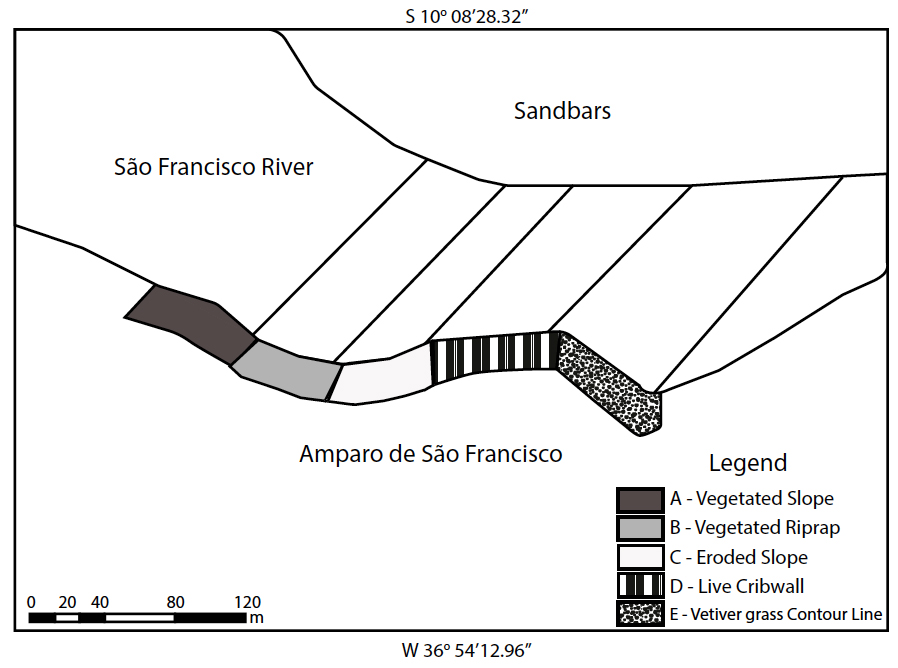
Figure 2 Representation of transects with the points of sediment collection in the experimental area in the the São Francisco Riverbank.
Among the evaluated treatments Vegetated riprap (B), Live cribwall (D) and Vetiver grass contour line (E) as soil bioengineering techniques and vegetated slope (A), and Eroded slope (C), located in the right margin (Figure 3). Vegetated Riprap is one of the most widespread soil bioengineering techniques, which are characterized by the use of rocks to protect the base of unstable slopes, and which are commonly associated with other techniques that use live stakes or geotextile in third middle and upper slope. Live Cribwall used inert materials, such as rocks as riprap (at the slope toe), wooden logs and clamps, together with biological materials also associated to brush layer for slope stabilization. The vetiver grass contour line is per- Georeferencing of each treatment was carried formed by Vetiver grass (Chrysopogon zizanioides out using the GPS Garmin eTrex Vista HCx, and of (L.) Roberty)) planted in contour lines, obeying the transects, which were delimited with the aid of the concavity of the river margin. an optical level Geodetic_Arise model, a compass, and stakes to mark the beginning and the end of each transect, enabling the correct orientation for the collections. Bathymetry or cross-section profiles of the river channel was carried out according to the orientation of each transect, using the Eagle_cuda 242 echo sounder to measure the depth of the channel in the period of 2013 to 2015.

Figure 3 Evaluated treatments: Vegetated slope (a), Vegetated riprap (b), Eroded slope (c), Live cribwall (d) and Vetiver grass contour line (e).
The sampling of the suspended sediments load was carried out at five different points along each transect (P1 = riverbank, P2 = beginning of the thalweg, P3 = middle of the thalweg, P4 = end of the thalweg, and P5 = margin of the sandy bar) at 20, 40 and 60% depth (Figure 4). The thalweg corresponds to the line of greater depth of the river with stronger flow.

Figure 4 Representation of the collection points: (P1 = river-bank, P2 = beginning of the thalweg, P3 = middle of the thalweg, P4 = end of the thalweg, and P5 = margin of the sandybar) RM = Right Margin the LM = Left Margin (Sand bar).
Collection was not carried out in some stretches of the banks which had strong presence of aquatic macrophytes. To make up for this problem, collection was carried out in points located immediately prior to the occurrence of dense vegetation, and another immediately after, in the direction previously established by the transect, and the three predetermined depths.
The collection of water-sediment samples was carried out by the Van Dorn bottle (Aquatic BioTechnology, 2020) and tape measure to get the correct depth of the collection. Samples were then packed in 1L polystyrene bottles, properly identified, and stored in coolers with ice, in order to prevent algae growth, and then stored during up to one week, in a refrigerator for further sediment concentration analysis.
Water-sediments samples were homogenized, and 100 ml subsamples (aliquot) were collected in three replications each, and placed in glass flasks, properly identified, weighed on a precision scale, and placed in an oven to dry at 105±2°C for complete water evaporation ( adapted from Wetzel y Likens, 2013).
Before placing the samples in the glass flasks, the recipients were thoroughly washed with distilled water, and placed in an oven to dry at 105 ± 2°C, and subsequently weighed on precision scale. After water evaporation, the flasks were removed from the oven for cooling in order to be weighed again (Carvalho, 1994).
The amount of suspended sediment load (SS) of each sample was calculated by the difference between the weight of the flask with the sediments and weight of the flask without the sediments. The average of the three replications was obtained. Afterwards, the total suspended sediment load was calculated considering the river discharge, by the equation proposed by Carvalho (2007):
Total suspended sediment load (g/day) = 86400 x Q x C, (Eq. 1) In which:
C = concentration, in mg/L; and 86400 = total seconds in 24 h.
All results were converted to tons per day.
The data were systematized and subjected to analysis of variance to determine significance at the 5% level (Test F) by the Tukey (Tian et al., 2018), using the statistical program SISVAR (Ferreira, 2011).
RESULTS AND DISCUSSION
The progressive decrease in the São Francisco River discharge is due to several years of low rainfall throughout the river basin, especially the upper and middle stretch facing upstream, which are responsible for more than half of the river discharge. In the years of 2013, 2014, 2015 and 2016, the discharge, in the Lower São Francisco (LSF) River were 1200 m3/s, 1100 m3/s, 900 m3/s and 800 m3/s, respectively (ANA, 2016). This situation has led to the decrease of the river water level, which contributed to change in its geomorphological and hydrosedimentological dynamics. By that time, the lower course of the São Francisco River has suffered progressive water level reduction, resulting in a small changes in the channel bathymetry explained by its low river discharge with water velocity below 0.75 m/s (ANA, 2016) (Figure 5).
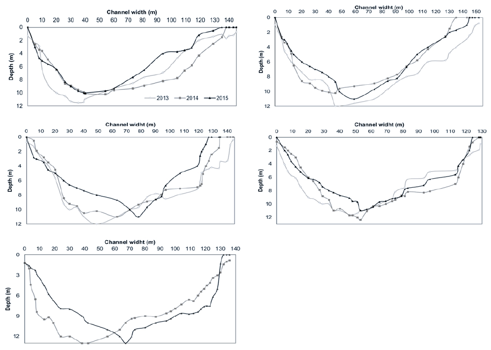
Figure 5 Cross-section profile of the transects in the period of 2013 to 2015. Vegetated Slope (a); Vegetated Riprap (b); Eroded Slope (c), Live Cribwall (d); Vetiver grass contour line (e).
Downstream discharges of the Xingó Hydroelectric Power Plant are made up of two parts: water flow (liquid discharge), and sediments flow (solid discharge), both interacting with each other and with the channel morphology. This interaction results in changes in the processes and in the morphology of the channel (Prasad, Lohchab, Singh, Nain, y Kumari, 2019). During the low flow, it was observed that the relation between the strength of the discharge and its sediment load released by the reservoir decreased over the years, and has greatly influenced the geomorphology changes in the river channel, justified by the ratio between the erosivity of the discharge and the erodibility of the banks.
To the evaluation of changes in the river channel by its cross-section profile by the time, morphological changes in the channel were found, and the Transects B (Vegetated Riprap) and C (Eroded Slope) showed the greatest depths in the year of 2013, when compared with other transects, showing a slight distance from the thalweg to the riverbank. This behavior in the river channel morphology was reported by Xie et al. (2018) when analyzing the Lower Yellow River (LYR), and by Akhter et al. (2019), when studying the Teesta River, proving that changes in the river discharge are affected by changes in the channel morphology.
On the transects starting in the banks with Vegetated Riprap (B) and Live Cribwall (D), the displacement of the thalweg was very slight. However, in the case of the transect starting in the Eroded Slope (C), the distance from the thalweg to the side bank was higher charactering a change in the cross-section. In the transect starting in the bank of the Vetiver grass contour line (E), related to the data of the years 2014 and 2015, the change in the cross-section is even more remarkable, deepening the channel toward the other river bank, explained by the largest concavity of the bank at this site. Once the river is a dynamic body, and despite the low river discharge, it has active erosion, and it carves its channel changing its morphology.
There are also changes in the sediment dynamics, in different depths, as well as the proximity or distance from banks, influencing sediments concentration, as it was also verified by Tran y Strom (2019). Geomorphological changes are also intensified by sediment deposition in fluvial processes (Bomer, Wilson, y Datta, 2019), which contributes to the changes in the river channel. Thus, in relation to the suspended sediment load, it is always found a connection to dams operation since they control the hydrological regime of the watercourse (Forján et al., 2018; Gonchukov, Bugaets, Gartsman, y Lee, 2019)
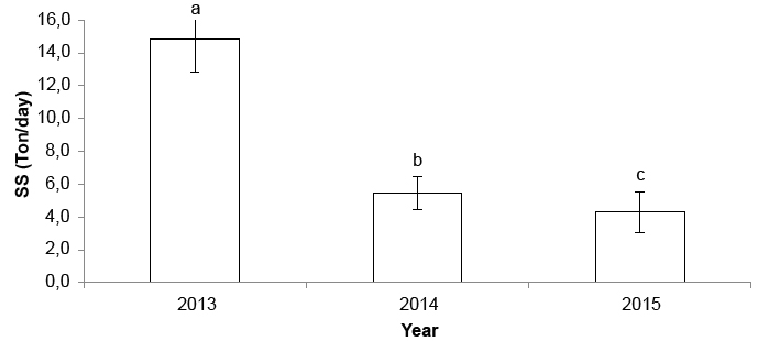
Higher sediment input was observed in 2013, which was statistically different when compared to the three years of collection (2013, 2014 and 2015), and this was the year with the highest flow, 1200 m3/s during the evaluated period. In subsequent years, the LSF river discharge reduced, with decreasing values in sediment input (Figure 6). The same response was reported by Grilli et al. (2020) and Theuring et al. (Khan et al., 2018), who found that the periods of higher flow rates corresponded to greater amounts of sediment transported. Medeiros et al. (2011), when analyzing the suspended sediment load supply in the Lower São Francisco, over the years of 2001, 2004 and 2007, also observed significant changes in water discharge and suspended sediment load in the coastal zone, in this case, associated with climate spatial variability with drought and flood events.
By analyzing the suspended sediment load input in the different treatments, where the transects start, the greatest value in transect A (32,14 tons/ day) in the year of 2013 was observed (Figure 7). In addition to the progressive reduction of the flow in the period of 2013 to 2015, which contributed to the reduction of suspended sediment load, it is inferred that the strong presence of aquatic macrophytes species at the slope toe may have contributed to the decrease in sediment input in this stretch, since the presence of these species strongly increased during this period, and thus reducing water turbidity.
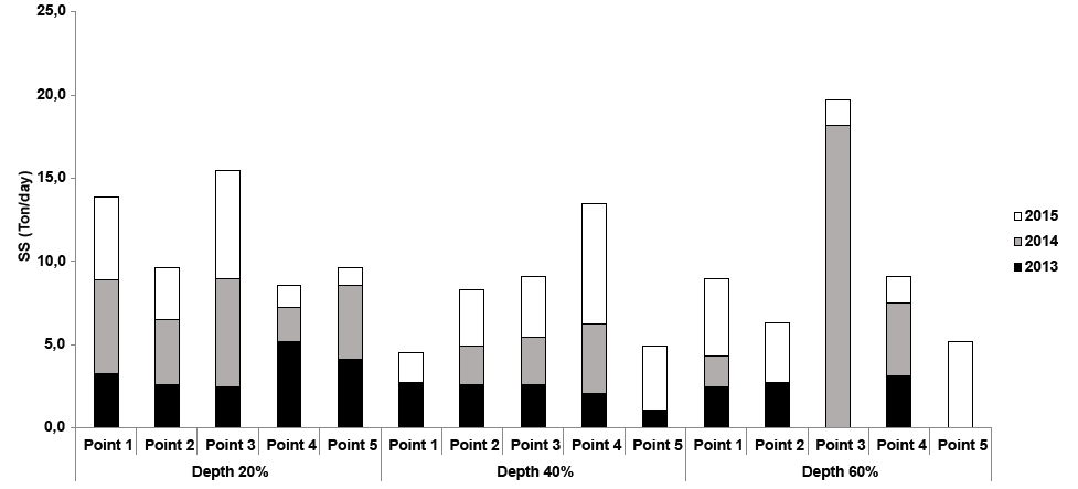
Figure 7 Suspended sediment load in the cross-section profile in Transect A (Vegetated slope) at five collection points, in the years of 2013, 2014 and 2015.
The presence of aquatic macrophytes is important, as nursery and food for the development of the aquatic fauna, and also helps to protect the slopes, since their biomass forms a barrier that dissipates the kinetic energy of water movement, before it reaches the slope (Jones, Consuegra, Börger, Jones, y Garcia de Leaniz, 2020; Jung, Fernandes, Möller, y García-Rodríguez, 2020). Carniatto et al. (2020) also associated the reduction in the amount of sediment by the presence of macrophytes in their studies.
By assessing the river bank, at the slope toe, where soil bioengineering techniques were build (Vegetated Riprap, Live Cribwall and Vetiver grass contour line), there was lower sediments input, confirming the effectiveness of these techniques in stabilizing slopes, avoiding or reducing undercutting, and consequently controlling erosion processes. In transect B, which starts at the Vegetated Riprap, the low suspended sediment load was found. In fact, Riprap is one of the most widespread soil bioengineering techniques, which are characterized by the use of rocks to protect the base of unstable slopes, and which are commonly associated with other techniques that use live stakes or geotextile in third middle and upper slope.
When Point 1 (river bank) of Transect B (Vegetated Riprap) was analyzed, it was observed that the largest sediment input occurred in the last year sampling, although no statistically significant difference was found when compared to the other sampling points (Figure 8).

Figure 8 Suspended sediment load in the cross-section profile of Transect B (vegetated Riprap) at five collection points, in the years of 2013, 2014 and 2015.
In order to build the vegetated Riprap in the slope toe, in the year of 2011, the volume and the depth range of rocky material considered the values of minimum average water level that were higher than those currently observed, going through a long drought period.
By assessing the sediment input of Transect D (Figure 9), which starts at the point where it was build the Live Cribwall, a gradual increase was observed at point 1, at 20% depth, but with no relevance.

Figure 9 Suspended sediment loads in the cross-section profile in Transect D (Live Cribwall) at five collection points, in the years of 2013, 2014 and 2015.
Among the soil bioengineering techniques build in the studied area, Live Cribwall is the most recent one. With the progressive reduction of the river discharge in the past three years, this technique, which uses inert materials, such as rocks as riprap, wood and clamps, together with biological materials as brush layer for slope stabilization, presented the slope toe exposed to the ebb and flow of water, by reducing the presence of aquatic macrophytes that covered and protected the slope, promoting increase in sediment input at 20% depth.
In the Eroded Slope a decrease of the input of suspended sediment loads was observed at a depth of 20% at point 1, due to the low discharge, i.e., low water volume and low flow rate, and hence erosion processes (Figure 10). Moreover, the presence of aquatic macrophytes also contributed to minimize the ebb and flow of the water at the slope toe, preventing the undercutting and collapsing of soil blocks, as also mentioned by Santos et al. (2020), also important for ecological features, such as in the increase of the biodiversity and other ecological important services as well.

Figure 10 Suspended sediment load in the cross-section profile in Transect C (Eroded Slope) at five collection points, in the years of 2013, 2014 and 2015.
In the transect E (Vetiver grass contour line), samples were collected only in the years of 2014 and 2015. At points 1 and 2, which reflected the influence of this soil bioengineering technique, it is noticed a decrease in sediment input (Figure 11). Another characteristic of this transect is that towards downstream Xingó Hydroelectric Power Plant, Transect E is the last site of the studied bank, which is influenced by the volume of sediment transported from the other treatments upstream.

Figure 11 Suspended sediment loads in the cross-section profile in Transect E (Vetiver grass contour line) at five collection point, in the years of 2014 and 2015.
The Vetiver grass contour line is located in a concave margin, where fluvial erosion is more intense (Figure 3). Moreover, at this point, the soil has a more sandy texture and low cohesion, which facilitates the detachment of individual particles by the water movement on the banks.
For suspended sediment loads transport in the thalweg, there was significant difference for the three years of collection. The year of 2013 presented the highest transported sediment rate, and was then correlated with the highest river discharge that occurred in that year, with a decrease in the following years. This condition is related to its own energy originated in the hydraulic turbulence, which also acts on the characterization of sediments transport(Seo, Ko, y Son, 2020).
Finer particles are found in bank areas, where the hydrodynamic energy pattern is lower. Since the thalweg is an area of great kinetic power of the water, sediment concentration would occur by sands of medium, thick and very thick grains with gravels, poorly selected, in the bed of the river channel (Kumar y Ojha, 2019; Maity y Maiti, 2017; Naganna, Deka, Ch, y Hansen, 2017). Sediment transport is directly related to the hydraulic flow of the river, and this can be influenced by hydrological factors, such as the amount of rainfall and its frequency and intensity, and by human activities, such as improper use of the banks. These conditions may intensify erosive processes, and thus increase the erosion rate and hence increase suspended sediment loads (Wu et al., 2018)such as hydraulic structure design, flood control and reservoir operation. The rainstorm modes along the upper mainstream of Yangtze River (UMYR).
CONCLUSIONS
Sediment transport was higher in 2013, the year of the highest river discharge, when the highest flow occurred, which presented progressive reduction in the following years.
The Vegetated Riprap technique proved to be the most efficient protection to the riverbank, with the lower suspended sediment input, followed by Live cribwall, Vetiver grass contour line being efficient to control the erosion processes in the slope toe, among the soil bioengineering techniques.
The observed distance between thalweg and the river bank contributed to the reduction of erosion in the bank and the sediment supply as well.
The changes in the river discharge are very important to the amounts of sediments originated from the river banks, and for the quantification of transported sediments originated from the upstream discharge. The lowering of the water level is of the great concern regarding to the possible recurrence of erosion processes due to the ebb and flow at the slope toe, since the river discharge was below the minimum average practiced in the last 40 years.
DATA AVAILABILITY STATEMENT
The data that support the findings of this study are openly available in Discover Mendeley Data at DOI:10.17632/xxbcj8nnjh.1, reference number Mendeley Data, V1.

