


 nova página do texto(beta)
 Inglês (pdf)
 Artigo em XML
 Referências do artigo
 Enviar este artigo por email
 Citado por SciELO
  Similares em
SciELO
Similares em
SciELO 
 Permalink
Introduction
The mangroves forest are ecosystem service providers such as regulation of droughts and land degradation and supporting services that include soil formation, nutrient recycling, and cultural, recreational, spiritual, religious and other non-material benefits (MEA, 2005; Moreno-Casasola and Infante-Mata, 2009; Vo et al., 2012). The effects of changing climate generate new uncertainties regarding environmental stability and they increase the vulnerability of critical habitats. In this context, mangroves help to reduce the vulnerability of coastal communities to sea level rise, storm surges and debris movement (Prato, 2008; Yañez-Arancibia et al., 2010 and Spalding et al., 2014).
To understand the importance of the environmental services supplied by mangroves, it is necessary to analyze the not explicitly link and the equilibrium between the ecosystem function and integrity on the one hand, and on the other hand the goods and services they provide, social benefits and human well-being to local human settlements (Mori and Takemi, 2015; Costanza and Folke, 1997; EFECT, 2005; Vo et al., 2012; Schmidt, 2016).
In the Ecosystem based adaptation (EbA) approach, biodiversity and ecosystem services, are part of a strategy that could help people to adapt to the adverse effects of climate (CBD, 2009; Lhumeau and Cordero, 2012). Although the EbA lacks a specific methodological and conceptual framework, sees the people, their society and their culture as an integral part of ecosystems, linking the ecological systems and socio-cultural (Lhumeau and Cordero 2012). In Mexico, the EbA is increasingly integrated in institutional structures and has emerged as a multifunctional and efficient tool that promotes the reduction of the impacts of climate change on the lives and livelihoods (Munang et al. 2013, Wamsler et al 2014, Ojea 2015, Brink et al. 2016) and the security of peoples who are in a situation of vulnerability to climate change, as well as other environmental stressors. The principles of the EbA, have been taken up in this research, applied on study of the social perception, using an analysis of a different geographic scale, over effects of extreme weather events and the identification of anthropogenic hazards. The principle of participatory planning from EbA was used on the analysis of adaptation strategies considering the interests of the stakeholders and in this sense, was supplemented by the implementation of surveys to recognize the perception of the people about the appropriation of the resources, the hydrometeorological hazards in the region and the environmental services of protection that they are provided by the mangrove (Schliep, 2008). La Encrucijada is a biosphere reserve located in Pacific coast near Guatemala frontier. The mangrove is well preserved and is considered as the tallest in North America, reaching heights of 20 to 40 m (Tovilla et al., 2009; Adame et al., 2015). But as in other mangroves on the country, there are logging problems, no regulated fishing and some pollution, nevertheless, reforestation programs have a great promotion, community perception of local capabilities to face climate extremes has not been studied. People’s perceptions of ecosystem contribution to livelihoods, of risk and adaptive capacity should be at the core of initiative design and performance evaluation systems and this would provide insight on the social determinants of adaptation (Villanueva, 2011). The above because sometimes the concern of the people does not match the threats in the area, and therefore the actions of government to manage risk, are not successful (Schliep, 2008, Tam and McDaniels, 2013). Although the components of the perception of risk are multiple and are related to the objectives of the study concerned, it being understood as an interpretation built as a result of a social process that may differ from the actual objective and probability of occurrence of the phenomenon. It has been shown that the outrage, the acceptability of the risk, cultural aspects, exposure to a hazard, confidence and preference are variables that influence the perception of the risk of a population against various threats. The perception of risk has been defined as a subjective assessment of the probability of being victims of a particular type of event and the magnitude of the consequences (Zebrowitz, 1983, Tam and McDaniels 2013, Salvador-Ginez et al. 2017). A few international agencies have promoted empowering strategies to diversify local economy (CONANP, 2015), but adaptive strategies do not contemplate a sense of belonging to socio-organizational structures or traditional perspectives. In Mexico, 60 of the 176 protected areas are wetlands that by their ecological characteristics are important in the conservation of global biological diversity (SEMARNAT, 2014), these areas are inhabited by autochthone rural people (Bezaury-Creel et al., 2009) which economic activities and use of resources are limited by local and national regulations to protect biodiversity and conservation status.
The present study discusses the role of La Encrucijada Biosphere Reserve as a socio-ecosystem capable of producing a wide range of goods and services for communities due to its biophysical condition. We focused on taking advantage from local perception of its inhabitants of being part of their capabilities to face the climate variability change and extreme climate events. The three objectives of this study are: 1) To get a diagnosis of socioeconomic conditions to evaluate its local vulnerability to climate extremes; 2) To applying questionnaires to local people to clarify the social perception of their environment and how they can identify the protection services from the mangroves and; 3) To evaluate coastal ecosystem functionality thought land use change evaluation, as a protection against hurricanes, sea level rise and storm surges.
This approach would contribute to eager communities living in protected areas, to be engaged and to be proactive in promoting the ecosystem conservation and, thereby, to adapt to the changing climate.
Study area
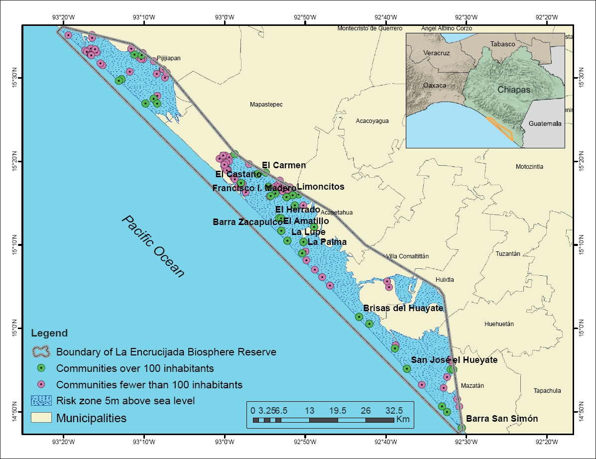
The Biosphere Reserve named La Encrucijada is in the State of Chiapas, Mexico, in the Pacific Coastal Lowlands physiographic region it was declared a protected area by the Mexican federal government in 1995, and was established as a RAMSAR site in 1996 (Figure 1). This Biosphere Reserve covers 144,848 ha stretching over the six municipalities of Pijijiapan, Mapastepec, Acapetahua, Villa Comaltitlan, Huixtla and Mazatan. It includes two elongated coastal lagoon systems that correspond to two core areas, La Encrucijada and Palmarcito. It is characterized by an area covered by mangroves and patches of deciduous seasonal and lowland forests, as well as tropical freshwater forested wetlands, floating and underwater vegetation, coastal dune vegetation and water bodies. The marine area extends over 29,214 ha. Five coastal lagoons connected by a system of seven rivers and the two lagoons and estuarine systems of Chantuto-Panzacola and Carretas-Pereyra. The main economic activities are agriculture and fisheries (CONANP, 2008; Adame et al., 2015). The reserve is located in the coastal region known as Costa de Chiapas that according to Ortiz and de la Lanza (2006) “is characterized by extensive sandy beaches with a steep slope and thick and medium texture due to its exposure to the southern waves and it is a barrier coast parallel to the coast that receives the waters of the Suchiate River towards the sea with sediment transport”.

Figure 1 Communities surveyed about environmental services in La Encrucijada Biosphere Reserve, Chiapas, Mexico.
The climate is warm and humid, with abundant summer rains. The maximum annual rainfall is 3000 mm distributed from May to November (Magaña and Caetano, 2005). The average annual temperature is 28°C, remaining constant throughout the year and generally above 22°C. To be a coastal region, is exposed to tropical cyclones although are rare, 3 to 8 is the frequency of direct incidence of tropical cyclones from 1 January 1940 until 31 December 2007 of any intensity (Cotler, 2010). However some extreme events have affected the region, for example: the rivers in the region have been subjected to intensive rectification following hurricanes Mitch (1998) and Stan (2005). The first protection levees were built along the Novillero, San Nicolas and Coatan rivers. The main environmental hazards are tropical storms, and lagoon and mangrove sedimentation and siltation enhanced by extreme hydrometeorological events. The three afore-mentioned rivers, together with the Pijijiapan and the Vado Ancho, have a high level of pollution due to agrochemical products and, to a lesser extent, organic wastes from the communities (CONANP, 2003). The persistent, bioaccumulative and toxic pesticides like 2,4-D, atrazine and paraquat are present. Concentrations exceeding the ecological criteria for sediments have also been detected for DDT metabolites in the Coatan river outlet, as well as for chlordane and DDT metabolites (both obsolete) in the Huixtla river outlet in the Hueyate estuary (IMTA, 2007; Hernandez, 2014). Forest fires are another threat to the biodiversity of the region. These are lit in order to capture wildlife for local consumption and to extend the croplands and pastures (Mendez, 2005; Barrios, 2015). Agriculture has intensified the conversion of the original vegetation to planted crops or pasture paddocks. Agricultural land expansion is limited by the presence of mangroves, cattail marshes and nearby saline lands. This vegetation is frequently felled and the wood is sold for house building and for posts on which to dry tobacco leaves (CONANP, 2003; Tovilla et al., 2009).
Data and methods
From a hermeneutic approach (Carcamo, 2005, Angel, 2011) and with descriptive statistics, we identified and analyzed information from official statistical sources from the National Institute of Statistics, Geography and Informatics; INEGI and National Council for the Evaluation of Social Development Policy; CONEVAL and results of the application of a written questionnaire and interviews, about: the social, cultural and economic situation of the communities in the region, their relationship with the surrounding ecosystems and how the people use the mangrove resources, as well as their level of information regarding environmental protection services and their perceptions regarding subsistence and hydrometeorological events. On next activity the size, structural integrity and the level of conservation of the original composition of species, was used indirectly to analyze the functionality of the ecosystem. If the mangrove is preserved ecosystem services will be maintained, including protection against tropical storms, sea level rise and storm surges (Vo, 2012; IPCC, 2014; Schmidt, 2016). Thirdly, once the causes of social vulnerability from the communities were identified, local actions must be proposed. This activities method entailed the following:
Connectivity: The structural connectivity among coastal plant communities was analyzed along seven transects of different length due to variation in the vegetation coverage; wetland vegetation profiles were obtained to identify the state of conservation and landscape structure, from analyzed the different types of coastal vegetation presence according to the arrangement and physical distribution (Grimaldi, 2015): a) changes in vegetation type (biological, phenological and growth form, in tree species height and in mangroves condition of the aerial roots), b) the local representativeness of the species for each type of vegetation (mangrove, tropical freshwater forested wetland, coastal dune vegetation, low tropical forest, spiny shrubs and crops), c) connectivity identifying the continuity between the different types of coastal vegetation or break continuity by anthropic use, d) change in vegetation coverage generated by anthropic uses or by natural events e) integrity of the vegetation determined by the contact with potentially adverse land use (Rodriguez-Zuñiga et al. 2013) as ecotourism, human settlements, lighthouse, crops or livestock and f) microtopography on the basis of the information of the escarpment beach (millimeters) and profiles of the slope. The transects were placed transversely to the barrier islands, according to the different types of land use. On each transect, micro-topography was determined with a hose level (Flores-Verdugo and Agraz-Hernandez, 2009), and changes in vegetation type (biological, phenological and growth form) were recorded. The height of the trees in the mangrove forest was recorded by hypsometer in sites near transects, on the barrier islands and on the mainland, with the technique of the nearest neighbor analysis, ten trees measured in every site on a perimeter of 40 m.
Land cover change: The change on mangroves that cover the reserve, was analyzed from SPOT-5 satellite images from the year 1975 to 2008 Series I and Series V from INEGI, were masked to select portions with a high probability of presence of mangrove (data available from CONABIO). The images were processed with ArcGis, based on the Digital Terrain Model (DTM) from INEGI (1:250,000 scale, 15 m resolution) and through the classification by CONABIO to then add the areas corresponding to the vegetation of interest.
Hazards: Information on tropical storms was obtained from the National Meteorological Service and the System of Inventory of Effects of Disasters (DESINVENTAR, 2015). We compared these data with the results of the surveys and interviews that we conducted, to explore the perception of the people of communities and those responsible for the civil protection system of each of the municipalities regarding (a) hazards in the region, and (b) environmental protection services against intense winds, floods and high waves.
Diagnosis: Information from official statistical sources such as regulatory, climatic and socio-environmental allowed description of the communities within the reserve: population, housing conditions, economic activities, economically active population, social cohesion and poverty indicators (INEGI, 2010; CONEVAL, 2014). Information available for all the towns of the reserve was analyzed statistically and mapped with ArcGis.
Social perception: Perception of the environmental services (April 28th to May 3rd, 2014 and June 22th to July 3rd, 2015) (Zebrowitz, 1983, Schliep, 2008, Bayon, 2016, Marin-Muñiz et al. 2016) was investigated through 162 semi-structured written questionnaires in 9 communities in the core area (Figure 1). The study sample was non-probabilistic and consisted of 162 older people, 82 women (50.6%) and 80 men (49.4%), between 18 and 85 years of age, with an average of 43.11 years and a standard deviation of 15.65 years. All participants were asked for their consent, after information of the study and agreed to participate (Salvador-Ginez et al 2017). The sample size was obtained by two methods (Hernandez et al., 2010 and STATS®), for a confidence level of 90% with a maximum acceptable error of ±10; this level was chosen because the respondents were selected by being older than 18 years, live permanently in the towns of La Encrucijada and depend economically of activities linked directly with the Biosphere Reserve.
Local Civil Protection System: Authorities’ from Civil Protection System representing the six municipalities were interviewed through an open-ended questionnaire with guiding questions (June 22nd to July 3rd, 2015) about damage caused by hydrometeorological events, and about early-warning systems and infrastructure that each municipality applies under extreme events, and how the warning mechanisms operate at the community level.
Adaptive Capacity: The ability to adapt to climate variability expressed as the degree of dependence on mangroves was evaluated through the comparison of statistical socioeconomic diagnosis and survey results. The surveys and interviews were applied according to the perception of: a) use of mangroves, recognition of the authority and identification of civil organizations, b) sense of belonging to the place, c) existence of educational campaigns, and d) willingness to participate in mangrove conservation and restoration in enhanced resilience initiatives.
Results
Connectivity
This Reserve is part of a biological corridor of coastal wetlands that have continuity with saws and marine environments while maintaining ecotones of great importance for the ecosystem services. This continuity coastal has a hydrologic level by the continental shelf of the Gulf of Tehuantepec, and the continental shelf between the basins from the Sierra Madre Occidental and the Sierra Madre of Chiapas, extending this biological corridor to Guatemala (CONANP, 2008). The coastal plain is characterized by being a plain of little slope (CONANP, 2008). The conservation status of the vegetation, was evaluated in 7 transects considering the connectivity of the different ecosystems of the wetlands on the island of barrier of La Encrucijada. Two types of connectivity were observed: continuity and break continuity by anthropic use. In five of the transects monitored we noted the continuity between the different types of vegetation and although the mangrove covers variable lengths, depending on the width of the island of barrier and the mangrove forest is noted in a good state of conservation. In the two transects with human settlements, appreciated the break in the continuity of the wetland vegetation. On the transect 4 the mangrove was not found and although in the transect 6 was observed in a band disturbed mangrove on 23 meters. This vegetation is being kept artificially, because it belongs to the ecotourism center called Barra de Zacapulco.
On the microtopography the height of the escarpments of beach in 6 of the transects are between 0.53 to 3.53 m (Figure2) which allows this elevation to provide protection against flooding by sea level rise and storm surges, it was noted that the highest level on the transects was found in the vegetation of the low tropical forest or with agriculture and was descending toward the area of mangrove or lagoon. The synthesis of the results of the characteristics analyzed to assess the structural connectivity among the transects are presented in Table 1. Data related with structural connectivity of coastal plant communities are combined with a summary of environmental services provided by these different types of vegetation in Figure 3. Survey respondents identified most of the environmental services provided and the uses they gave each of the mangroves ecosystems, and they showed an interest in keeping in a good condition the ecosystems on which they depend.
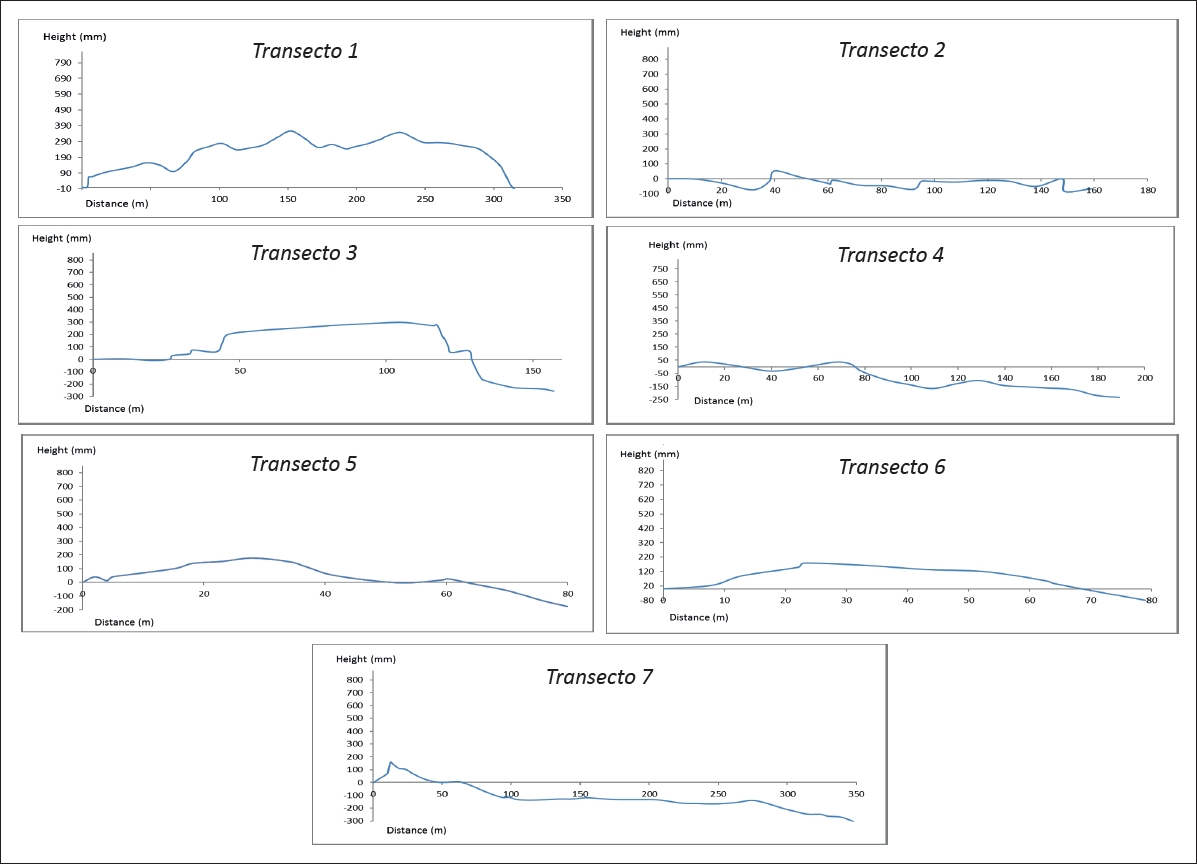
Table 1 Characteristics to structural connectivity over transects.
| Aspects analyzed | Description | Transect 1 | Transect 2 | Transect 3 | Transect 4 | Transect 5 | Transect 6 | Transect 7 |
| Changes in vegetation conditions | Biological, phenological and growthform,intreespecies height and in mangroves conditionoftheaerialroots | Dune vegetation ( 10 to30cm),spinyshrubs (7 m), low tropical forest in good condition(10to15m), mangrove in good condition(16t021m), seedlings, flooded 40 cm,aerialrootsofup to 1m | Dune vegetation in good condition (10 to 30 cm), spiny shrubs (2 m) low tropical forest in good condition (10 m) | Dunevegetation(20 cm),spinyshrubs(7to 8 m), mangrove in goodcondition(13to 36 m) , seedlings, flooded60cm,aerial rootsofupto1.5m | Dune vegetation disturbed | Dune vegetation in goodcondition(10to 30 cm), low tropical forest in good condition(10to15m), mangrove forests in good condition, seedlings, flooded 40 cm,aerialrootsofup to 1m | Without dune vegetation, palmar presence isolated, mangrove disturbed, average height 20 m, dead trees, flood 30 cm, roots with height up to 40 cm | Dune vegetation ( 10 to30cm),spinyshrubs (7 to 10 m) and low tropical forest (10 to 15 m) in good condition,crops,wide extensionofpalmarof 10 to 15 m height, mangrove forests in good condition 18 to 31 m), seedlings, flooded40cm,aerial rootsofupto2m |
| Representativeness of species according to type of coastal vegetation | Based on Grimaldi, 2015 | Dune, spiny shrubs, lowtropicalforest, mangroves | Dune, spiny shrubs, low tropical forest | Dune, spiny shrubs, mangroves | Dune | Dune, low tropical forest, mangroves | Mangroves | Dune, spiny shrubs, lowtropicalforest, mangroves |
| Connectivity | Continuity and break continuity by anthropic use | Continuity between the different types of coastal vegetation | Continuity between the different types of coastal vegetation | Continuity between the different types of coastal vegetation | Break continuity by anthropic use | Continuity between the different types of coastal vegetation | Break continuity by anthropic use | Continuity between the different types of coastal vegetation |
| Change in vegetation coverage* | Anthropic changes or by natural events | Anthropic changes | - | - | Anthropic changes | - | Anthropic changes | - |
| Integrityofthevegetation* | Contact with potentially adverse land use (ecotourism, human settlements, infrastructure, crops, livestock) | Lighthouse | - | - | Human settlements | - | Ecotourism | Crops, Palmar |
| Microtopography | Escarpment beach in millimeters (mm) | 356 | 53 | 246 | 37 | 176 | 179 | 162 |
* Modified from Rodriguez-Zuñiga et al. 2013

Land cover change
The vegetation observed was mangroves, tropical freshwater forested wetlands, coastal dune vegetation, tropical low forest, spiny shrubs, crops and aquatic vegetation. The core and buffer zones are predominantly mangroves and tropical freshwater forested wetlands. The rate of vegetation conversion from 1975 to 2000 was 0.65% (620 ha/year), with a total transformation of 15,500 ha over those 25 years. Biosphere Reserve was established over the period of 1992-2000, and the rate of transformation decreased to 0.50% (441 ha/year); 2,200 ha were changed from mangroves to seasonal agriculture and 336 ha for pastures (CONANP, 2003). The cumulative changes in land use from 2000 to 2008 (Figure 4) affected 5,128 ha (641 ha/year).

Figure 4 Cumulative changes in land use from 2000 to 2008 in La Encrucijada Biosphere Reserve, Chiapas, Mexico.
The main changes occurred in the tropical freshwater forested wetlands (957 ha), palm groves (398 ha), mangroves (318 ha) and dune vegetation (115 ha), mostly due to conversion to grassland for agriculture. Fires caused by humans burned the native vegetation and were frequently precursors of those changes (CONANP, 2003).
Hazards
The most hazardous events perceived by the communities are related with extreme hydrometeorological events and those associated with anthropogenic environment modification. Only 8% of the population surveyed perceived tropical storm as danger, the threats perceived were the increase in sea level, flash flooding and heat waves. Of those surveyed, 58% perceive a loss of mangroves and 66% an increased sedimentation in mangroves in response to extreme events. Almost all inhabitants recognize that mangroves protect against floods (89%), intense winds (99%) and storm surges (81%). Only 8% of communities However, the intense rainfall that comes with tropical storms usually triggers flash flooding, mud and rockslides along the reserve watersheds. The river rectification program started in 1975 allows a large quantity of sediment to be transported downstream creating major problems such as siltation, a decrease in water quality and an increase in chemical pollutants. These problems were aggravated during hurricanes Paulina (1997) and Mitch (1998). During Hurricane Stan (2005), a cumulative rainfall of 1300 mm caused great damage in the reserve. The Civil Protection authorities have established that land below 5 m above sea level is at risk from flooding (Figure 5), and this could involve 116 of the 298 localities (39% of the population of the reserve; INEGI, 2010).
Diagnosis
The 16,250 inhabitants of the reserve are distributed among 298 communities. There are differences in the access to services of localities analyzed. In the Villa Comatitlan municipality 37.3% live in poverty. Huixtla has the largest percentage experiencing social poorness (22.7%) and the lowest percentage with access to electricity (21.8%). Pijijiapan has 36.7% illiteracy and 82.3% have an income below subsistence level, whereas 53.5% of the population of the whole reserve have incomes below that level. Mazatan has the lowest percentage with access to health services (CONEVAL, 2014). The average duration of schooling of the population of the reserve aged 15 years or over is 5.03 years; 93.8% have television, 74.7% have radio, 28.3% have a cell phone, 14.9% have a landline telephone and only 1.7% have a computer with internet connectivity. Regarding the shortcomings of services, 76.3% of dwellings do not have water inside the building, 37.5% have a compacted earth floor, 22.5% have no sewerage and 6.1% have no electricity (Figure 6). The economically active population is between 15 and 64 years (INEGI, 2010). Only 32.7% of the population is economically active: 29.1% male and 3.6% female. Women head 4.1% of the households.
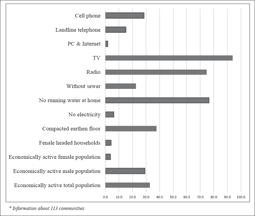
Figure 6 Economics and community services in 113 communities in La Encrucijada Biosphere Reserve (data from INEGI, 2010).
Social perception
We carry out 162 surveys in nine communities located in the core area of La Encrucijada in order to determine the use of mangroves. According with survey the mangrove is most frequently used as a source of wood for fires (52%), or construction (44%), although there are other uses such as food or medicine (4%). Effects of remote high-energy swell events, such as those of May 1st and 12th, 2015, were observed by the inhabitants and for which a specific survey regarding this phenomenon was conducted. These events originate in extra-tropical systems on the eastern coast of Australia, propagate to the western coast of South America and reach the southern coast of Mexico (Innocentini et al., 2016). A questionnaire indicated that 87% know where to obtain permission to use mangrove products, 56% is aware of the support given to the community to use and conserve mangroves, and 51% identified tourism activities carried out in the community. They know that the services provided by the dune areas include retention against flooding and tides, protection from pollutants, and freshwater extraction, although they do not recognize fresh water as an environmental service.
Local Civil Protection System
Owing to a lack of equipment and personnel, Civil Protection authorities are not able to provide timely assistance to the population living on the coast. Since these authorities are located inland in municipalities, the evacuation from risk areas is very complex and, in most cases, it requires boats. In addition, the people surveyed have no contact with the Civil Protection authorities or warning information on environmental threats. In addition, media coverage is insufficient and only a few presidents of fishing communities have shortwave radio.
Adaptive Capacity
Of the surveyed population, 38% are engaged in fishing, 11% in trade, 9% in ecotourism (hosteling services), 8% in crop production, 2% in livestock and 2% in reforestation or environmental promotion. Housewives make up 26% of the surveyed population and are involved in handicrafts, medicinal plant crops and other products obtained from mangroves, or have backyard chicken, duck or turtle hatcheries. 87% of the population is aware that a permit issued by the authorities is required for the use of resources. More than one-half of the respondents knew that government support is provided to the population for the use and conservation of the mangroves. Overall, 61% of the surveyed population is engaged in some conservation activity, and of those who are not, 4% are willing to do so. Only 36% know of organized groups for mangrove conservation and 76% know that educational activities take place in their communities. Of those of productive age (18-59 years old) 85% have a sense of belonging and plan to continue to live in their community.
Local vulnerability
According to the municipality poverty indicators, only 32.7% of the population is economically active, and 3.6% of this percentage are women most in activities that are considered informal or temporary, support programs or temporary employment promotes some by different agencies (e.g. sustainable fisheries, cleaning of beaches, mangrove reforestation). All respondents to the survey reported some activity that generates economic benefits for their families. However, the fishing cooperatives obtain nearly all the financing and the rest of the population feels excluded; these programs should be restructured to provide for all community members. Almost 50% of the surveyed population is economically active compared with only 32.7% in Mexico as a whole. This discrepancy may be attributed to the short-term and informal economic activities within the reserve, related to mangroves (medicinal uses, handicrafts and cooking for tourists). Official statistics exclude the role of women apart from household activities, whereas women within the reserve also contribute in additional resources such as food and handicrafts sales, ecotourism, agriculture, fishing, animal breeding and conservation activities supported by the government.
Although these communities are not fully able to assess the environmental services, they understand the need to preserve the reserve, they identify themselves as part of the reserve and they are aware that their incomes depend on their relationship with the mangroves. Over 80% of the 162 respondents are conscious of the protection that mangroves provide against extreme hydrometeorological events, and are willing to participate in conservation actions and to diversify their economic activities. They realize that slow but continuous degradation of the ecosystem could reduce the goods and services provided and affect community interests.
The underlying cause of the change in land use is related to the establishment of feed pastures for livestock and of crops (watermelon, sesame, melon). These activities are inconsistent with guidelines of the Mexican Protected Areas Law. In addition, the inhabitants pointed out the effects of the intensive management of rivers. With the levee constructions along the rivers one would expect that the communities near the banks would be protected against floods. However, the changes in the river flow have produced undesirable effects, including increased sedimentation along the riverbeds near the coast (Mendez 2005), siltation of coastal lagoons, reduced fishing productivity, a loss of mangroves areas that help groundwater recharge, increased salinization of the water consumed by the communities, and the disappearance of flood buffer zones. All this has greatly increased the vulnerability of the reserve. Other concerns expressed by the population refer to the reforestation of the tarquinas (areas of material dredged from rivers and lagoons to remedy lagoon sedimentation). The perception of the community is that the tarquinas reduce the lagoon areas. A lack of exchange of information on sustainable fishing techniques among fishermen has limited the possibility of establishing responsible and sustainable fishing in the region. Of major concern to the inhabitants are discharges of pollutants into some lagoons (from banana and papaya crops and mining), and the culture of African palm (Elaeis guineensis Jacq.), an exotic, invasive and highly competitive species. The vulnerability of the region is strongly influenced by the socioeconomic activities and the exposure to hazards identified in this survey. Income from fishing, the most important economic activity (over 50% of population reserve), is declining as a result of the environmental degradation of the lagoons. The population is positive about participating in activities associated with mangrove conservation in order to maintain and improve the environmental services system. The communities are also willing to continue using resources from mangroves and coastal areas for their livelihoods in sustainable ways. Only 36% of respondents identified organized groups, and this may indicate weak social cohesion concerning conservation issues promoted by non-governmental organizations. The sense of belonging and participation of the population expressed by 85% of those of working age should be harnessed. The consumption of native freshwater turtles and iguanas was not referred to in the surveys, although this has traditional and cultural roots and is common in the region.
Discussion
EbA has emerged as an efficient and multifunctional tool that promotes the reduction of the impacts of changing climate on livelihood (Munang et al., 2013; Wamsler et al., 2014; Ojea, 2015). In Mexico, some governmental or non-governmental organizations want to incorporate this approach in studies of vulnerability and adaptation (Brink et al., 2016) particularly in regions of environmental vulnerability. In 2010, Mexico had 56 RAMSAR sites with mangrove vegetation covering ~522, 397 ha (Rodriguez-Zuñiga et al., 2013). The presence of the escarpment on the beach combined with the extensive coverage of vegetation in a good state of conservation, as well as the connectivity that exists between the different types of vegetation, have been sufficient to provide the service for the protection of floods, on the contrary in areas where there is no coverage of vegetation and the beach escarpment is low, people perceived that the floods is a menace to their homes and facilities. Since 39% of the inhabitants of the La Encrucijada Biosphere Reserve may be exposed to flooding, the Family and Community Plans for Civil Protection and a warning system against hydrometeorological hazards should be implemented. Data gathered through community-based mangrove monitoring should become a fundamental component of the warning system. This would help the communities to improve the conservation and to manage the environment, and would also benefit end-users of the data, particularly those engaged in ecosystem and biodiversity conservation and adaptation to climate change. The large potential female workforce should be engaged in implementation of adaptive strategies and enhancement of the local economy.
Mexican authorities have developed a first approach through the “Program of adaptation to climate change in the protected natural areas of the Sierra and Coast of Chiapas complex” (CONANP et al., 2011). Although it is a good effort, the measures proposed are very general and do not have the necessary local structure to operate. The program lacks the vision and information that would enable promotion of specific actions to address the civil protection of the populations, as well as to build the capabilities required to harmonize conservation of mangroves and wetland ecosystems with sustainable economic development in order to reduce the vulnerability of the region. The region is subject to a range of hazards associated with hydrometeorological events, and lack of investment in prevention creates vulnerability as a precondition to disaster (Landa et al., 2008). Future work must build environmental, economic and social indicators, to determine the vulnerability of the reserve. Local vulnerability is heavily influenced by the activities of the population, the use of ecosystems, the economic situation, the lack of education, the closeness of communities to the sea and the exposure of the region to river flooding caused by storm surges and waves. Although several studies have provided evidence (Mendez, 2005; Tovilla et al., 2009; Carbajal-Evaristo, 2014; Machuca, 2014), the next steps are to plan relocation of the exposed communities in case of need, as well as to evaluate and monitor the protection services available in the reserve regarding the hazards that have already been identified by the communities. The present research group is studying through biophysical parameters, the effects of winds and tides on coastal ecosystems to evaluate the mangrove vegetation protection services over human settlements within the reserve. Evaluation measures, environmental monitoring and the establishment of actions for the economic activation of the area have been recommended to local authorities because of the present study. The following are recommendations to aspects that are of concern to the communities of the reserve and that were manifested at the time of the surveys: about the rate of siltation of the lagoons, should be studied in order to identify the effects in fishing potential of lagoons. Quality and control of sedimentation should be analyzed, even with a cost-benefit analysis that should include any possible solutions. Programs directed towards economic recovery and risk management require communication campaigns and awareness of the benefits of the environmental services provided by the mangroves as well as awareness of any actions that may cause the deterioration of the systems. Land use and fire control and a restructuring of economic activities are issues that also need to be addressed. Mechanisms should be established for the people to venture into alternative economic activities including planting vegetable crops as well as breeding iguana, freshwater turtle and even crocodile where safe, to replace the declining fisheries. Several inhabitants supported this opinion and expressed their interest in establishing farms for breeding of freshwater turtles for human consumption. Establishment of these hatcheries could be an alternative source of protein now that the fisheries are declining; they would be consistent with mangrove conservation and the guidelines for the reserve, particularly considering the geographic location and its remoteness from supply centers and the decreasing fisheries that make it difficult to obtain protein products. The shortage of good-quality local food is a limiting factor for ecotourism here, so these hatcheries may represent another area of opportunity.
Conclusion
Vulnerability coastal reduction through the restoration of coastal habitats such as mangroves can be an effective measure against storms, saline intrusion and soil erosion. Since human communities live in coastal protected areas, the EbA, a bottom-up approach, can identify the problems the communities face and the local conditions required for sustainable change. Surveys of local perceptions determine the needs of the communities and detect aspects they perceive as major concerns, given that the cultural values and the status quo can be barriers in adaptation planning. Communities in natural protected areas are restricted in terms of economic activities, and their major concern may be access to adequate food, rather than long-term aspects such safety from hydrometeorological events. To assist community engagement in the conservation of mangroves, the government must implement participatory tools based on consultation of local inhabitants. Individual perceptions of possible hazards and how these may relate to the local environment could assist the development of capabilities in human communities, generating a strategy that enables people to progress from perception to the realization of structured actions. The La Encrucijada Biosphere Reserve has a conserved coastal wetland with the tallest mangroves in North America. Reforestation and conservation dominate the activities in the region but marginalization indices are dominant in the population. Although the local communities are conscious of the ecosystem services obtained from this vegetation, they take no action against undesirable sedimentation or illegal logging, and their fishing practices are not sustainable. The EbA approach can evaluate local vulnerability to climate extremes, climate change and surges, and focuses on developing capabilities for a warning system. Previous studies in Mexico have not combined a consideration of, on the one hand, mangroves as a natural system capable of producing a wide range of goods and services for coastal environments and communities with, on the other hand, evaluation of eco-socioeconomic aspects relevant to the well-being of the population and to long-term adaptation measures. Development of local capabilities and appropriate financial mechanisms for coastal ecosystems are still controlled by the Mexican central government; national strategies must enable local populations to adapt and meet the challenges of climate change. Sustainable conservation of mangroves based on EbA should be applied to all Mexican coasts, protected coastal areas and RAMSAR sites where there are settled populations, with the aims being to maintain the environmental services, to preserve the mangroves and to protect those coastal zones.

