


Serviços Personalizados
Journal
Artigo
 Inglês (pdf)
 Artigo em XML
 Referências do artigo
 Enviar este artigo por email
Indicadores
-
 Citado por SciELO
 -
 Acessos
Links relacionados
-
 Similares em
SciELO
Similares em
SciELO
Compartilhar

 Permalink
Investigaciones geográficas
versão On-line ISSN 2448-7279versão impressa ISSN 0188-4611
Invest. Geog no.75 Ciudad de México Ago. 2011
Geografía física
Hydrologic response of the drainage basins that intersect Las Grutas town, Argentina
Respuesta hidrológica de las cuencas de drenaje que intersectan el balneario Las Grutas, Argentina
Sibila A. Genchi*, María E. Carbone**, María C. Piccolo**, Gerardo M. E. Perillo***
* Instituto Argentino de Oceanografía, CC 804, CCT–CONICET–BB, Edif. E1, B8000FWB, Camino la Carrindanga km. 7.5, Bahía Blanca, Argentina. E–mail: sgenchi@criba.edu.ar.
** Departamento de Geografía y Turismo, Universidad Nacional del Sur, B8000FWB, and Instituto Argentino de Oceanografía, Bahía Blanca, Argentina.
*** Departamento de Geología, Universidad Nacional del Sur, and Instituto Argentino de Oceanografía, Bahía Blanca, Argentina.
Received: 14 April 2010
Final version accepted: 2 November 2010.
Abstract
The town of Las Grutas, in a semiarid region on the north west coast of San Matías Gulf (Argentina), is intersected by two drainage basins that are activated immediately after intense rainfall events. These events generate flows capable of producing local flooding, such as the flood of April 2004. The purpose of this study is to establish the hydrologic behavior of these geoforms and the manner in which the land use interacts with them. The lack of hydrometric records necessitates the explanation and prediction of hydrologic responses through empirical approaches such as fluvial morphometry and the USDA Soil Conservation Service curve number (1972), supported by Geographical Information System technology. The study area has characteristics that favor the concentration of runoff into streams during extreme events. First–order segments play an important role in the hydrologic response, showing great potential to receive surface runoff. The effect of urbanization produces an additional runoff of 17.3% and 2.1% in the respective basins. A potential increase in the number of these extreme events in the future due to climate change may lead to more disturbances in the urbanized area. The results of the present study will contribute to the implementation of measures to mitigate the consequences of floods.
Key words: Drainage basin, hydrologic response, fluvial morphometry, direct runoff, Las Grutas town.
Resumen
La localidad de Las Grutas está emplazada en una región semiárida, en la costa Noroccidental del Golfo San Matías (Argentina) y es intersectada por dos cuencas de drenaje que responden ante eventos de precipitaciones intensas. Estos eventos generan flujos capaces de producir riesgos de inundación local, tal como la inundación de abril de 2004. El objetivo de este trabajo es establecer el comportamiento hidrográfico de dichas geoformas y la manera en el cual los usos de la tierra interactúan con ellas. La falta de registros hidrométricos conduce a explicar y predecir respuestas a través de aproximaciones empíricas como el análisis morfométrico fluvial y el número de curva del Servicio de Conservación del Suelo de los Estados Unidos (1972), apoyados en sistemas de información geográfica. El área en estudio presenta características que favorecen la concentración del escurrimiento en cauces durante eventos extremos. Los segmentos de primer orden juegan un rol importante en la respuesta hidrológica. El efecto de la urbanización produce un efecto adicional del 17.3 y 2.1% de escurrimiento en cada cuenca. El incremento potencial del número de eventos extremos en el futuro debido al cambio climático, podría conducir a mayores perturbaciones en el área urbanizada. Los resultados contribuirán a implementar medidas que mitiguen posibles consecuencias de los peligros de inundación.
Palabras clave: Cuenca de drenaje, comportamiento hidrológico, morfometría fluvial, escurrimiento directo, Las Grutas.
INTRODUCTION
The drainage basin is a well defined entity in which every component element affects its hydrologic response to rainfall input, in a complex interaction that tends to reach a dynamic equilibrium. Within the context of fluvial landscape, anthropogenic processes may result in irreversible changes to the land surface and drainage pattern (Larson and Booth, 2001). Las Grutas town, located in a semiarid climatic region on the north west coast of San Matías Gulf, Argentina, is intersected by two drainage basins hereafter called North Basin and South Basin (Figure 1). These fluvial systems are activated immediately after intense rainfall events, which generate flows capable of producing urban flooding, such as the one in April 2004.
Fluvial systems can be described and measured in various ways (White et al., 1998). Particularly in arid and semiarid lands where extreme rainfall events occur, non–gauged basins are often studied empirically (e.g., Navarro, 1986; Durbude and Purandara, 2001; Perucca and Paredes, 2005; Ayala et al., 2006; Esper, 2008). In the present study, the lack of hydrometric records necessitates the explanation and prediction of hydrologic responses through empirical approaches such as fluvial morphometry and the application of the USDA Soil Conservation Service (SCS) Curve Number (CN), (1972), supported by Geographical Information System (GIS) technology.
Preliminary results concerning the hydrographic characteristics of the two study basins were documented in Genchi et al. (2008). Only a few studies have been reported in the study area but they are at regional scale and merely highlight the temporary regime of the drainage networks (e.g., Gelós et al., 1992; Schillizzi et al., 2003; Kokot, 2004).
The purpose of this study is to establish the hydrologic response of the NB and SB and the manner in which the land use interacts with them. Extreme rainfall events are becoming more common as a result of climate change, and it can be expected that this will lead to more disturbances in the urban area. The present results will contribute to the implementation of measures to reverse local effects of flood hazards on property values.
MATERIALS AND METHODS
A quantitative study of the drainage basins that intersect Las Grutas town was based on information available in cartographic products (e.g., geological and topographic charts) and aerial photos which were systematized with a GIS through the ArcGis 9.0 application. This research was complemented by direct observations and measurements on the ground.
The climatic data were obtained from the National Meteorological Service of Argentina. The only weather station in the region, San Antonio Oeste station, is 4.5 km from the town (40° 44'S; 64° 67'W) at 20 m above mean sea level (a.s.l.) (Figure 1). Decadal climatic statistics over a period of 40 years (1961–2000) and daily rainfall records (1981–2008) were used in this study.
The morphometry of the two drainage basins was analyzed. The drainage basins were delineated according to topographic criteria. Digital elevation models, aerial photographs (1:80 000) and topographic charts (1:100 000) were employed to identify fluvial geoforms. Direct measurements of morphometric parameters (e.g., area and perimeter of the basin, length and number of streams) were automatically obtained from GIS and visually controlled later, to detect possible interpretation errors. Indexes based on variables related to terrain relief, network topology and basin geometry were calculated (Tables 1, 2 and 3).
The SCS–CN (1972) method was employed to estimate the direct runoff for an isolated storm. Soil types within the study area, based on the Río Negro Province soil map (1:250 000), were classified into SCS hydrologic soil groups. Land use classes were mapped on the basis of visual interpretation of black and white aerial photos (right angle) at scales of 1:80 000 for the years 1963, 1986 and 2007.
Direct runoff was determined by (Chow et al., 1994)
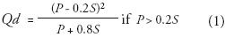
where Qd is the direct runoff (mm), P is the storm precipitation (mm) and S the potential maximum retention (mm). CN and S are related by
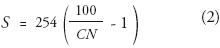
where CN is a variable coefficient based on land use, soil group and vegetal cover. This CN is adjusted to the previous moisture conditions in terms of the accumulated rainfall for a period of five days before the storm event (dry, < 13 mm; normal, 13 to 28 mm; wet, > 28 mm). Accumulated rainfall prior to the selected event indicates a wet condition. Thus, the adjustment to this condition is expressed by
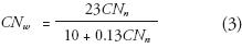
where CNw and CNn correspond to wet and normal conditions, respectively. Lastly, the weighted CN value of each basin was calculated as

where AHsg is area of the hydrologic soil group (%).
STUDY AREA
Geomorphology and Geology
The study area is on the north west coast of San Matías Gulf, over a littoral pediment (Genchi et al., 2008) which is joined to the foot of an ancient alluvial plateau. The area is characterized by a low topographic relief with a mean slope of 1.6%. There are two isolated hills called Bandera and Dirección, whose elevations are 50 and 100 m a.s.l., respectively (Figure 1). The coastal area is strongly dominated by landforms that result from marine erosion, such as active cliffs and wave–cut platforms.
The pediment is covered mostly with Holocene colluvial deposits, which come from the alluvial plateau and lower units such as Tertiary marine and fluvial sediments (Martínez et al., 2001). The pediment originated through tectonic, fluvial and aeolian processes (Ayesa et al., 1995). Marine sandy–clay sediments corresponding to the Gran Bajo del Gualicho geological formation come to the surface, sometimes half covered with Quaternary colluvial material (Martínez et al., 2001).
Climate
The study area is in a semiarid zone under marine influence. In terms of the Gaussen (1954) aridity index, this area is subdesert with approximately 270 dry days. The months of May, June and July are considered semi–wet. The continentality index of Currey (1974), expressed as the amplitude of the annual oscillation of temperature, is 1.03, which indicates a type of oceanic climate.
The mean annual temperature is 15.1° C. The mean annual relative humidity is 57% and reaches its maximum values in winter (70%). The mean monthly evapotranspiration estimated according to the Christiansen (1968) equation ranges from 180 mm in summer to 35 mm in winter. The predominant wind direction is north–west from March to November, and south–east during summer months. The mean annual wind speed is 5.05 m s–1.
The study area is at the southern boundary of the South Atlantic subtropical anticyclone. Precipitation occurs as rain with a mean annual value of 227.2 mm for the period 1910–2000. Annual precipitation had a positive trend over that period (Figure 2). Variation among months is moderate (Figure 3), with a standard deviation of 4.6 for the twelve mean monthly values.
The extreme daily rainfall for each month over the period 1981–2008 (Figure 3) ranged between 33 and 102 mm d–1. The heaviest rain (102 mm d–1) represented 46% of the total annual precipitation for the year 2004. In addition, this event of intense and abundant rainfall corresponds to the historical maximum.
Type and hydrologic soil group
Aridisol is the main soil order in the low rainfall zone of Argentine Patagonia, east of the Andes range. These soils have little pedogenetic development and very low organic matter content (<1%). The soil domains are Calciorthids (Typical subgroup), Paleargids (Petrocalcic subgroup) and Camborthids (Lithic subgroup). The former consists of coarse texture on the surface (fine gravels) and silt loam in deeper horizons. It is well drained and belongs to hydrologic group B with moderate permeability (Monsalve, 1999). Paleargid soil contains petrocalcic and argillic horizons that were formed under climatic conditions that differed from the present ones (Tchilinguirian and Pereyra, 2001). It, too, belongs to hydrologic group B. Lithic Camborthid soils occur in the upper part of the basins between streams. The marine clays present evidence of translation and deposition (Martínez et al., 2001). This soil corresponds to hydrologic group C with low permeability (Monsalve, 1999) and occupies an area of approximately 1.13 (13.8%) in the NB and 0.83 km2 (8.3%) in the SB (Table 4).
Vegetal cover
The study area belongs to the Monte phytogeographical Province, Estepa Arbustiva (shrubby steppe) District, Monte Austral Típico Unit (Cabrera, 1976; León et al., 1998) which is characterized by a shrubby steppe with several strata and low vegetal cover. The lower and middle strata, with heights varying between 0.5 and 1.5 m respectively, have the greater coverage (León et al., 1998). The upper stratum reaches 2 m in height and has a dispersed distribution. The shrub stratum is dominated by Larrea divaricada, a perennial < 1.5 m in height, whose leaves are adapted to arid conditions.
Land use
The economy in the study area is dominated by tourism in search of sunshine and beaches, and it is significantly associated with urban land use. The boom in tourism has led to accelerated urban expansion during the past two decades, primarily parallel to the coastline; the urbanized area was only 0.07 km2 in 1963, 1.4 km2 in 1986, but 3.7 km2 in 2007 (Figure 4). Urbanization represents 5.6% of the NB and 2.4% of the SB (Table 4).
Rural activity has little economic importance and is limited by low precipitation. Agriculture is confined to irrigated crops under intensive production systems with conservation treatment. Olive groves (Olea europaea) occupy 0.86 km2 (8.6%; Table 4 and Figure 4). Extensive livestock production, mainly sheep, is geographically dispersed near the town (Plunkett and Gastaminza, 2004).
MORPHOMETRY OF THE DRAINAGE BASINS AND STREAM NETWORKS
The town of Las Grutas is intersected by two fluvial systems that drain to the sea. The NB and SB cover an area of 8.2 and 10 km2, respectively (Genchi et al., 2008), (Figure 1), and are elliptical to circular (Table 1).
The hydrographic basins have a NW–SE orientation that follows the morphostructure (Figure 1). The altitudinal range is 0–80 m in the NB and 0–100 m in the SB, and their highest elevations are in the contact zone at the edge of the alluvial plateau. The mean slope of the NB (1.9%) is similar to that of the SB (2.4%).
The stream system is ephemeral and influent (Aparicio, 1997). The streams carry water only immediately after intense rainfall events (Hoyt, 1942; Wisler and Brater, 1959; Aparicio, 1997; Raghunath, 2006). The water table lies permanently below the streambed throughout. Water table depth varies between 60 and 85 m (Olivares and Sisul, 2005).
The drainage networks are composed of narrow streams whose maximum width at the mouth varies between 6 and 8 m. Most of the low–order streams are not well defined. Their cross–section is usually U–shaped. The slope above this is steep in the middle–low stretch. Accumulated sediments spatially discontinuous in the lower basin section take the form of debris cones showing the highest degree of erosive activity. During heavy storms, debris and fine material frequently become mobilized.
The drainage network is dendritic in both basins (Howard, 1967; Figure 1). It is associated with a soft structure with horizontal layers of Holocene colluvial deposits and Tertiary marine and fluvial sediments. The angles of confluence between two streams are approximately 45° (Figure 1). According to the Strahler method of ordering, the fluvial systems are fourth–order basins (Genchi et al., 2008). The variation of the logarithm of number of streams and the logarithm of mean stream length against orders indicates a strong relationship in both basins (Figure 5). These relationships confirm the Horton geometric progression laws (Horton, 1945).
The mean bifurcation ratio, which indicates the average variation of the number of segments between consecutive orders (Horton, 1945; Strahler, 1964), has a relatively high value in both NB and SB (Table 2). The drainage frequency, defined as the ratio between the number of streams of all orders and the basin area (Horton, 1932), is 5.3 km–2 for the NB and 7.6 km–2 for the SB. The torrential coefficient (Romero and López, 1987), represented by the drainage frequency of first–order segments, encompasses approximately 75% of the total drainage network (Table 2). Drainage density, defined as the ratio between the total stream length and the basin area (Horton, 1932), is approximately 3 km km–2 in each basin (Tables 2, 3; Figure 6).
The main stream length measured from baseline to the farthest point in the basin (Schumm, 1956) is 5.4 km for the NB and 7.3 km for the SB. The mean slope of the main stream is low in both cases (Table 2), although it reaches values of up to 4 in the upper part of each basin (Figure 7). The NB presents partial slopes with values slightly higher than in the SB, although the gradient of the main stream of the SB is not constant and is significantly steeper in the middle part (Figure 7a).
The time of concentration is defined as the time required for a parcel of water originating at the most remote part of the drainage basin to reach the basin outlet (Singh, 1992). According to the Kirpich (1940) formula the time is 71 min for the NB and 96 min for SB, while according to Johnstone and Cross (1949) the time is 59 min and 75 min, respectively. In contrast, the Témez (1978) formula indicated values of 142 min (NB) and 147 min (SB), (Table 2).
DIRECT RUNOFF FROM THE HYDROGRAPHIC BASINS FOR AN ISOLATED STORM
The direct runoff from a watershed depends on the total rainfall, land use, vegetal cover, hydrologic soil group and previous humidity. The selected storm corresponds to the historical maximum (102 mm d–1). Accumulated rainfall prior to this storm was 44 mm, which indicates a wet condition. A uniform distribution of rainfall across the surface of the NB and SB was assumed, taking into consideration the relatively small surface covered in both.
The amount of precipitation falling as rain totaled 102 mm over a period of 18 hours, with a persistent character between 22:00 (April 4th) and 05:00 h (April 5th), (Figure 8). According to the storm hyetograph, the highest intensity was 0.30 mm min–1 between 00:00 and 03:00 h (Figure 8).
The weighted CN for normal moisture conditions is 59.4 in the NB and 59.8 in the SB (Table 4), whereas the adjusted CN for wet conditions is 77.4 and 77.1, respectively. According to the latest values, the potential maximum retention is 75.3 and 74.3 mm. The direct runoff is 61.1 (NB) and 61.6 mm (SB). The mean runoff coefficient estimated as the ratio between drained volume and fallen precipitation is 0.51 for both basins.
DISCUSSION
The present functioning of fluvial geoforms depends on their history (Hoffmann et al., 2008) and evolves in a complex interaction that tends to reach a dynamic equilibrium. Both NB and SB are inherited from earlier climatic periods. It is clear that, with the advent of dry conditions the contemporary fluvial landscape was abandoned (Cooke et al., 1993) by the processes that formed it. The drainage probably changed from perennial to ephemeral, with the stream system apparently retaining its form, particularly the drainage density.
The study area consists of a low–energy fluvial environment in which massive discharges were the important land–forming agents. The present–day functioning of the fluvial systems is characterized by a temporary regime whose streams exhibit surface flow after extreme rainfall events. Sometimes, these events represent up to 20–40% of the total annual precipitation. In addition, the path of the storms usually exhibits a movement from NW to SE, coinciding with the orientation of the fluvial systems.
The morphometric properties of the two drainage basins are similar. The runoff is affected by maximum discharges, typical in small basins (Chorley, 1971). First–order segments are important in the hydrologic response. In both basins, these segments concentrate the highest density (~50%) and frequency (~75%), (Table 3), showing great potential to receive surface runoff during extreme rainfall episodes. The resultant time of concentration, which is influenced by the low slope of the main stream principally on the middle and lower segments, tends to raise the discharge time. Therefore, in the presence of heavy rainfall, all these characteristics indicate a potential increase in peak discharges and in durations of high flows in the lower stretches of the drainage networks. In addition, the U–shaped cross sections also show that the potential deepening of the valley during a storm is rapidly obliterated by post–storm conditions such as sedimentation of material, which is transported by the wind.
The dominant hydrologic soil group is B, which is characterized by moderate infiltration and slight runoff. The remaining soil group (C), of moderately high runoff potential, occupies a small area in the headwaters. The basins are covered mainly by shrubby steppe whose hydrologic condition is constant in response to the widespread prevalence of the extensive production system. The sparse cover favors surface runoff; however, the predominance of the hydrologic soil group B reduces the value of CN. Although the weighted CN obtained for the two basins are similar, they do differ somewhat (Table 4). The effect of urbanization (Chow et al., 1994) produces an additional runoff of 17.3% for NB and 2.1% for SB; the significantly greater effect in the NB is due to a major urban area and to a large number of paved roads, which cause a progressively greater fraction of precipitation to enter the channel rapidly. In contrast, the CN value for the SB is higher in the presence of cultivated land.
The direct runoff resulting from the isolated storm was estimated at about 60% of the total rainfall (102 mm d–1) in both basins. This extreme runoff event, which was exacerbated by wet antecedent conditions, caused urban flooding with significant water depth and velocity in zones of flow concentration, especially in the lower area of the NB. In addition, the rapid runoff on saturated soils made it very erodible.
Rapid urbanization of the town in the past two decades has caused its margins to reach both fluvial systems (Figure 4). Urbanization did not change the natural disposition of the streams but a large number of buildings are situated near the main stream. In addition, anthropogenic disturbances in the lower parts of the drainage basins (e.g., small channeled stretches, artificial fillers and stabilization of the bank with blocks) obstruct and redirect the runoff into the surrounding areas and contribute to increased flooding risks.
CONCLUSIONS
The study area presents characteristics that favor the concentration of runoff into streams during extreme events. The possibility of large flows is affected mainly by the physical property of the basins, whereas the anthropogenic effects are still small, but are increasing rapidly. Flood risks are higher in the lower basin of each fluvial system. The lack of a urban management plan best suited to the geomorphologic environment has allowed buildings to be constructed in vulnerable areas.
A risk factor is always present. An event of unprecedented severity may occur at any time (Chow et al., 1994). In this sense, the potential increase in the number of these extreme events in the future due to climate change may lead to more disturbances in the urbanized area that have to be taken into account in the field of spatial planning.
Morphometric analysis and the SCS–CN method provide a quantitative physical description of fluvial landforms, which is able to explain and predict potential hydrologic effects (Maderey, 1973; Linsley et al., 1988). However, further research focusing on the elements of complex fluvial response is needed. A suitable understanding of the hydrologic behavior requires stream discharge gauges and a detailed temporal scale within each extreme rainfall event, which will be systematized in hydrological models.
ACKNOWLEDGEMENTS
The authors thank Roberto Schillizzi and Jorge Spagnuolo for their contributions to the cartographic and photographic material. Also, the authors are grateful to Abel Molas, in charge of San Antonio Oeste weather station, for daily rainfall records. The research is supported by grants to M.C. Piccolo.and G.M.E. Perillo from Consejo Nacional de Investigaciones Científicas y Técnicas and Agencia Nacional de Promoción Científica y Tecnológica, Universidad Nacional del Sur
REFERENCES
Aparicio Mijares, F. J. (1997), Fundamentos de hidrología de superficie, Noriega, México. [ Links ]
Ayala, R., G. Páez and F. Araque (2006), "Análisis geomorfológico de la microcuenca El Guayabal, a propósito de la ocurrencia de las lluvias excepcionales de febrero de 2005. Cuenca del río Mocotíes, estado Mérida–Venezuela", Revista Geográfica Venezolana, núm. 48, Instituto de Geografía y Conservación de Recursos Naturales, Universidad de Los Andes, Venezuela, pp. 59–82. [ Links ]
Ayesa, J., D. Bran, C. López, A. Cingolani, G. Eiden, S. Clayton and D. Sbriller (1995), Evaluación y cartografía del estado de la desertificación. Transecta Provincia de Río Negro, Argentina, Proyecto Ludepa, INTA, EEA Bariloche–GTZ, Argentina. [ Links ]
Cabrera, A. L. (1976), "Regiones fitogeográficas Argentinas", in Parodi, L. R. (ed.), Enciclopedia Argentina de Agricultura y Jardinería, Acmé, Buenos Aires, Argentina. [ Links ]
Chorley, R. J. (1971), "The drainage basin as the fundamental geomorphic unit", in Chorley, R. J. (ed.), Introduction to fluvial processes, Methuen and Co. Ltd., London. [ Links ]
Chow, V. T., D. Maidment and L. Mays (1994), Hidrología aplicada, McGraw–Hill, New York. [ Links ]
Christiansen, J. E. (1968), "Pan evaporation and evapotranspiration from climatic data", Proc. Nat. Conf. Am. Soc. Civil Engrs., no. 94, Irrigation and Drainage Division, pp. 243–265. [ Links ]
Cooke, R., A. Warren and A. Goudie (1993), Desert Geomorphology, Butler and Tanner Ltd., England. [ Links ]
Currey, D. R. (1974), "Continentality of extratropical climates", Annals of the Association of American Geographers, no. 64, pp. 268–280. [ Links ]
Durbude, D. G., B. K. Purandara and A. Sharma (2001), "Estimation of surface runoff potential of a watershed in semi–arid environment. A case study", Journal of the Indian Society of Remote Sensing, no. 29, pp. 47–58. [ Links ]
Esper Angillieri, M. Y. (2008), "Morphometric analysis of Colangüil river basin and flash flood hazard, San Juan, Argentina", Environmental Geology, no. 55, pp. 107–111. [ Links ]
Gaussen, H. (1954), "Théorie et classification des climats et des microclimats du point de vue Phytogéographique", Actes du VIII Congrès International de Botanique, Paris, pp. 125–130. [ Links ]
Gelós, E. M., J. O Spagnuolo and R. A. Schillizzi (1992), "Las unidades morfológicas de la costa Oeste del Golfo San Matías y su evolución", Revista de la Asociación Geológica Argentina, no. 47, Asociación Geológica Argentina, pp. 365– 371. [ Links ]
Genchi, S. A, M. E. Carbone, G. M. E Perillo and M. C. Piccolo (2008), "Study of the temporary hydrographic networks as a conditioner of the urban morphology. Case Las Grutas beach resort, Argentina" (Abstract), Estuarine and Coastal Sciences Association 44 Congress, Instituto Argentino de Oceanografía, Bahía Blanca, Argentina. [ Links ]
Gravelius, H. (1914), Flusskunde. Goschensche Verlagshandlung, Berlin. [ Links ]
Hoffmann, T., A. Lang and R. Dikau (2008), "Holocene river activity: analysing 14C–dated fluvial and colluvial sediments from Germany", Quaternary Science Reviews, no. 27, pp. 2031–2040. [ Links ]
Horton, R. E. (1932), "Drainage basin characteristics", Transactions American Geophysical Union, no. 13, pp. 350–361. [ Links ]
Horton, R. E. (1945), "Erosional development of streams and their drainage basins; hydrophysical approach to quantitative morphology", Geological Society of America Bulletin, no. 56, pp. 275–370. [ Links ]
Howard, A. D. (1967), "Drainage analysis in geologic interpretation: a summation", American Association of Petroleum Geologists, no. 51, pp. 2246–2259. [ Links ]
Hoyt, W. G. (1942), "The runoff cycle", in Meinzer, O. (ed.), Physics of Earth. Hydrology, Mc Graw–Hill Book Company, New York. [ Links ]
Johnstone, D. and W. P. Cross (1949), Elements of applied hydrology, Ronald Press, New York. [ Links ]
Kirpich, Z. P. (1940), "Time of concentration of small agricultural watersheds", Civil Engineering, no.10. [ Links ]
Kokot, R. R. (2004), "Erosión en la costa patagónica por cambio climático", Revista de la Asociación Geológica Argentina, no. 47, Asociación Geológica Argentina, pp. 715–726. [ Links ]
Larson, M. G. and D. B. Booth (2001), "Effectiveness of large woody debris in stream rehabilitation projects in urban basins", Ecological Engineering, no. 18, pp. 211–226. [ Links ]
León, R. J. C., D. Bran, M. Collantes, J. M. Paruelo and A. Soriano (1998), "Grandes unidades de vegetación de la Patagonia extra andina", Ecología Austral, no. 8, Asociación Argentina de Ecología, pp. 125–144. [ Links ]
Linsley, R., M. Kohler and J. Paulhus (1988), Hidrología para ingenieros, McGraw–Hill Interamericana de México, México. [ Links ]
Maderey Rascón, L. E. (1973), "Obtención de los elementos físicos que influyen en el régimen hidrológico. Cuenca del río Pabellón, afluente del río Aguascalientes", Recursos hidráulicos, no. 2, pp. 166–177. [ Links ]
Martínez, H., C. Náñez, A. Lizuain, C. Dal Molin and A. Turel (2001) "Nacional de Cartas Geológicas de la República Argentina. Hoja geológica 4166–II (1:250000) San Antonio Oeste", Boletín 254, Instituto de Geología y Recursos Minerales, Buenos Aires, Argentina. [ Links ]
Miller, V. C. (1953), A quantitative geomorphic study of drainage basin characteristics in the Clinch Mountain area, Virginia and Tennessee, Technical Report, Office of Naval Research, Geography Branch, Columbia University, New York. [ Links ]
Monsalve Sáenz, G. (1999), Hidrología en la Ingeniería, Alfaomega, Colombia. [ Links ]
Navarro Hervás, F. (1986), "Flujos hídricos potenciales en una cuenca fluvial semiárida. Río Guadalentín", Papeles de Geografía Física, no. 11, Universidad de Murcia, pp. 35–43. [ Links ]
Olivares, G. and A. Sisul (2005), "Los recursos hídricos en el sector costero rionegrino", in Freddy Masera, R., J. Lew and G. Serra Peirano (ed.), Las mesetas patagónicas que caen al mar: la costa rionegrina, Ministerio de Familia–Gobierno de Río Negro, Viedma, Argentina. [ Links ]
Perucca, L. P. and J. Paredes (2005), "Peligro de aluviones en el departamento Pocito, provincia de San Juan", Revista de la Asociación Geológica Argentina, no. 60, Asociación Geológica Argentina, pp. 64–71. [ Links ]
Plunkett, S. and S. Gastaminza (2004), Ordenamiento y Protección de los Recursos Naturales de la Costa Atlántica de Río Negro, Pre–diagnóstico ampliado–Proyecto Viedma, Argentina. [ Links ]
Raghunath, H. M. (2006), Hydrology principles, analysis and design, New Age International Ltd., India. [ Links ]
Romero Díaz, A. and F. López Bermúdez (1987), "Morfometría de redes fluviales: revisión crítica de los parámetros más utilizados y aplicación al Alto Guadalquivir", Papeles de Geografía Física, no. 12, Universidad de Murcia, pp. 47–62. [ Links ]
Schillizzi, R. A., E. M. Gelós and J. O. Spagnuolo (2003), "Procesos de retracción de los acantilados patagónicos entre la desembocadura de los ríos Negro y Chubut. Argentina", Revista de la Asociación Argentina de Sedimentología, no. 11, Asociación Argentina de Sedimentología, pp. 17–26. [ Links ]
Schumm, S. A. (1956), "Evolution of drainage system and slope in badlands at Perth Amboy, New Jersey", Bulletin Geological Society of America, no. 67, Geological Society of America, pp. 597–646. [ Links ]
Singh, V. P. (1992), Elementary Hydrology, Prentice Hall, New Jersey. [ Links ]
Strahler, A. N. (1964), "Quantitative geomorphology of drainage basins and channel networks", in Chow, V. T. (ed.), Handbook of Applied Hydrology, McGraw–Hill, New York. [ Links ]
Témez, J. R. (1978), Cálculo hidrometeorológico de caudales máximos en pequeñas cuencas naturales, Ministerio de Obras Públicas y Urbanismo, Dirección General de Carreteras, España. [ Links ]
Tchilinguirian, P. and F. X. Pereyra (2001), "Geomorfología del sector Salinas Grandes–Quebrada de Humahuaca, provincia de Jujuy", Revista de la Asociación Geológica Argentina, no. 56, Asociación Geológica Argentina, pp. 3–15. [ Links ]
USDA, Soil Conservation Service (1972), Hydrology, in National Engineering Handbook, Us Govt., Printing Office, Washington, D. C. [ Links ]
Wisler, C. and E. Brater (1959), Hydrology, John Wiley and Sons, USA. [ Links ]
White, I. D., D. N. Mottershead and S. J. Harrison (1998), Environmental systems. An introductory text, Stanley Thornes Ltd., United Kingdom. [ Links ]

