


Serviços Personalizados
Journal

Artigo
 Inglês (pdf)
 Artigo em XML
 Referências do artigo
 Enviar este artigo por email
Indicadores
 Citado por SciELO
 Links relacionados
-
 Similares em
SciELO
Similares em
SciELO
Compartilhar

 Permalink
Investigaciones geográficas
versão On-line ISSN 2448-7279versão impressa ISSN 0188-4611
Invest. Geog no.70 Ciudad de México Dez. 2009
Unpackaging residential segregation: the importance of scale and informal market processes
Segregación residencial: la importancia de las escalas y de los procesos informales de mercado
Peter M. Ward*
* Department of Sociology, The University of Texas at Austin, 78712 N60 Austin, Texas. E–mail: peter.ward@mail.utexas.edu.
Abstract
This paper addresses two principal issues: a) the scale at which one examines urban segregation; and b) how informality, specifically accessibility to land markets and the process of land appropriation by low–income groups in Latin American cities, influences segregation patterns. Using Mexico City as a case study for Latin America, it shows that macro residential segregation levels are not becoming more polarized as many believe, due to informality of the market place and the weak state intervention through planning and zoning. However, there is a hardening of boundaries between adjacent neighborhoods as people turn to gated communities, largely for security reasons.
Case study material from three Mexican cities are presented to examine how the nature of residential land costs and market segmentation contributes to segregation in Latin American cities. In a second case study, data from peri–urban low–income self–build settlements (colonias) in Texas cities demonstrate how existing inequality patterns can be reproduced by differential access to land markets. They further argue a case that such isolated (rural) settlements serving nearby urban labor market, should also be included in any analysis of urban segregation patterns, even if they do not form part of the contiguous urban area.
Key words: Urban segregation, land market, scale.
Resumen
Este artículo se enfoca principalmente en dos temas: a) la escala a la que se examina la segregación urbana, y b) cómo los patrones de segregación están influenciados por la informalidad, especialmente en lo que se refiere a la accesibilidad al mercado de la tierra y a los procesos de apropiación de la misma por los grupos de menores ingresos en las ciudades de América Latina. Se toma a la Ciudad de México como estudio de caso de América Latina, y se muestra que los niveles macro de segregación residencial no se polarizan cada vez más –como se podía prever– debido a la informalidad del mercado y a la débil intervención del Estado a través de esquemas de planificación y zonificación. No obstante, se da un refuerzo de las fronteras entre barrios adyacentes conforme la gente encierra sus comunidades por razones de seguridad.
Se presenta material de tres estudios de caso en ciudades mexicanas para demostrar cómo la naturaleza de los costos de la tierra residencial y la segmentación del mercado contribuyen a la segregación en las ciudades latinoamericanas. En otro estudio de caso, los datos de unos asentamientos periurbanos, de bajos ingresos, autoconstruidos (colonias) de algunas ciudades de Texas, demuestran cómo se reproducen los patrones de inequidad debido a accesos diferenciales al mercado de la tierra. Asimismo, esos datos sirven para argumentar que los asentamientos aislados (rurales) que atienden un cercano mercado laboral urbano, deberían ser incluidos en el análisis de los patrones de segregación urbana, incluso si no forman parte del continuum del área urbana.
Palabras clave: Segregación urbana, mercado de la tierra, escala.
INTRODUCTION: STUDYING RESIDENTIAL SEGREGATION-PAST AND PRESENT
At different periods in the twentieth century various disciplines have taken an ephemeral interest in analyzing residential segregation patterns in cities. For example, drawing upon the ecological and botanical analogies of the late nineteenth centuries, the Chicago School of social ecologists held sway in the 1920s–30s with their representation of the urban mosaic starting with the classic work Robert Park in 1915– The classic model developed by his colleague E.W. Burgess' (1925) depicted a predominant concentric pattern in which the poor lived in the city center and the better off occupied rings of increasingly higher status as one moved outwards, driven by processes of invasion and succession of poorer and immigrant groups into the central core area. In the 1930s fellow sociologist Homer Hoyt added sectors to the Burgess model, these axes following topographical spines and communications routes, while his colleagues Walter Firey and others drew attention to the role of cultural and historical markers as anchor points for the elite in some city centers —such as Beacon Hill in Boston (see also Amato, 1970 for Bogotá). But having laid the pathway towards residential spatial analysis it seems as if sociologists largely lost interest at this point, and turned back to their more traditional métier of seeking to understand the behavior of social institutions, and the nature of social change, particularly as an outcome or urbanization and the impact of urbanism as a way of life (Wirth, 1938). By the 1960s this was leading to some of the classic sociological and anthropological works of the 1960s by Gans, Suttles, Whyte and others.
It was at this time that geographers principally took up the reins. Building upon Alonso's (1964) model of economic spatial patterns of cities (itself a throwback, of course, to Von Thunen's agrarian models of intensities of land usage), geographers began to experiment with different methods of spatially representing socio–economic and housing data spatially. Computing advances during the late 1960s into the early 1970s greatly increased geographers' capacity to generate "factorial ecologies" of cities (Berry and Kasarda, 1977; Clarke, 1966, 1971, 1973). These maps provided quite nuanced and disaggregated depictions of social patterns in cities based, as they were, upon factor–analysis correlations of clusters of variables that seemed to be closely interrelated. These clusters usually comprised race and ethnicity; socio–economic status; age and "stage" in the life cycle. And while they hinted at underlying processes, they never truly began to explain why people chose to live where they did, or how those aspirations were shaped, etc. Enter stage left a host of geographers whose survey work and research into cognitive behaviors sought to explain these underlying patterns (Robson, 1973; Timms, 1971; Downs and Stea, 1977).
This research by geographers, together with major advances in information processing and modeling techniques has created the multi– and interdisciplinary interest in the analysis of residential patterns and social processes that we observe. Indeed, sociologists in particular are looking with renewed interest at what geographers were doing during between the 1970s and the 1990s. While in the USA much of the initial interest hinged around the analysis of racial and ethnic patterns and heterogeneity, the advent of research by William Julius Wilson (1987) and others in the late 1980s shifted the focus away from just ethnic and racial heterogeneity and began to look more widely at socio–economic segregation (even those this was often correlated with ethnic and racial spatial patterns). This shift was important for two reasons: first, because it obliged us to look at the interrelationship between space and social sorting —the enquiry about the processes that drive segregation; and second, because we began to appreciate that living in particular residential spaces can lead to important outcomes in terms of access to education, economic, attitudes and aspirations, indeed to life chances in general. This is particularly true for the poor and for lower income groups who have less mobility to overcome negative externalities. Residential space is not only the medium for socio–economic separation with a sea of heterogeneity, but it also leads social segmentation among social groups within that residential area, and to the reproduction of social inequality.
Since that time the tools of analysis offered by GIS and remote sensing, improved modeling capacities and algorithms, and actual measures of residential segregation have all become much more sophisticated (Fossett, 2006). Contributions by sociologist/demographers such as Douglas Massey (Massey and Denton, 1988), John Iceland (2009), Sean Reardon (Reardon and Firebaugh, 2004) to mention just a few mark a renewed interest by sociologists in the importance of space, and in understanding the intersections between spatial and social impacts (Gieryn, 2000; Katzman and Reta–moso, 2005). My own department of sociology at the University of Texas is a good example of how the intersection between geography and sociology appears to be leading to the creation of a new cadre of doctoral students whose expertise combines sociological and demographic theory with a high level of sophistication in GIS and spatial modeling (Flores, 2008; Peters 2009; Aliaga 2010). Just to take their work as an example. Carolina Flores' work analyzes spatial heterogeneity in Santiago, Chile, and does so with great sophistication. But the core research question is to analyze the effects of Chile's school voucher system in overcoming the impact of residential segregation (where you live) and schools embedded within certain neighborhoods (where you go to school) has upon the outcomes of children's education, parental and teacher attitudes. Paul Peters' (2009) research in Lima and in Santiago is also highly sophisticated both in measuring residential segregation, but also in modeling change over time and the impact of political decision making, planning, housing production and transportation upon residential segregation patterns, and the direction in these patterns appear to be headed. And Lissette Aliaga's research in Bogotá and Lima uses sophisticated GIS techniques to depict and characterize how informal economic activities are embedded in neighborhoods, and to examine the relationship between petty commodity enterprises and the homeplace and the neighborhood.
The work of these three former students is an excellent segue to the themes and issues that I wish to address in this paper. First I want to assess whether residential segregation in Latin American cities is increasing –often assumed in the past. Second, to examine how informal land development processes that were rife from the 1950s onwards have shaped urban residential patterns, spatial segregation and social segmentation in cities. A third and interrelated issue when analyzing and measuring residential segregation is to clarify the scale of analysis, since measures of segregation are likely to be different at the macro and micro scales. If the traditional adage "space matters" still applies, then we need to know the why, the how, and at what level?
LATIN AMERICA: SCALE AND PROCESS
This aforementioned thematic and disciplinary tracking of residential patterns and segregation in cities can also be traced in work on Latin America. Classic studies by Schnore (1965) for a number of cities argued in favor of a reverse Burgess model in cities since the elites traditionally lived in and around the city center while the poor lived in the expanding periphery of proletarian self–help communities (Johnston, 1973; Clarke, 1983). And while largely true then (and today), this model, too was far too overdrawn: many elites had moved out to the peripheral suburbs, usually sectors in a la Hoyt; middle classes invaded those former elite homes through a process of "filtering" rather than "invasion"; while the poor migrants moved into tenements in the city center, and invaded or bought land at the periphery where they built and consolidated their homes and neighborhoods creating different rings of working class housing in which the most recent and least consolidated was further out. Often overlain by a number of sub–center urban nuclei comprising old towns absorbed by city growth or satellite suburban centers a la Harris and Ullman (1959), these residential processes offered a broad–brush "new" Latin American ecological model of the 1970s and 1980s (Ward, 1998; Clarke and Howard, 1999; Clarke, 2006; Griffin and Ford, 1981; Pacione, 2001).
Since that time, city growth, globalization and post–modernism; commercial developments, rising insecurity, and our technical capacity to capture data more effectively and at a more disaggregated level, has allowed us to generate much more nuanced understandings of Latin American city structures and residential segregation patterns. The hallmark of Latin American urban models today is that they are increasingly complex and fragmented (Ford, 1996; Clarke and Howard, 1999; Janoschka, 2002; Meng et al., 2006, Peters and Skop, 2007). Janoshchka's (2002) fragmented model is an almost unfathomable rendering of the classic one by Ford's (1996), but it is helpful in drawing attention to the multiple "islands" of land–uses that exist today: islands of production (industrial spaces); "new" residential islands (high class condos and gated communities); islands of commerce (shopping centers); and islands of poverty (social housing, especially poor neighborhoods, etc.) within broad belts of low income residence.
Until relatively it was not possible to undertake serious ecological or residential segregation analysis in the region since the data were rarely available at a sufficiently disaggregated level comprising small sufficiently spatial units. Thankfully this is no longer the case in most cities, and increasingly data are available for what in Mexico are defined as AGEBS (Áreas Geográficas Estadísticas de Base) that allow us to undertake a more nuanced analysis of the residential mosaic. These AGEBS and their equivalent in other cities usually display data at the neighborhood and sub–neighborhood level. In some cases it is possible to view data at the block (manzana) level although confidential protocols are usually (and rightly) in place to limit public access. This paper will take up two principal issues: a) the scale at which one examines urban segregation; and b) how informality, specifically accessibility to land markets and the process of land appropriation by low–income groups in Latin American cities, influence segregation patterns.
First, that of scale and the level at which one seeks to measure residential segregation in cities of the Americas. At a macro (general) scale I will argue that there are good reasons to explain why segregation is not intensifying in most large Latin American cities —despite knee–jerk assertions to the contrary. Using the case of Mexico City I will show how the existence and nature of informal land supply reduces the capacity of the market to distribute land according to regular bid prices which, if left unfettered, would generate a growing polarization of residential segregation. With one or two exceptions (that prove the rule —the Federal District of Lucio Costa's Brazilia, or Dictator Pinochet's Santiago, and other occasional ad hoc eviction programs throughout the region), the state has generally allowed informality to proceed, and neither dirigiste interventions nor widespread public sector housing provision have come to shape the city fabric– as they so often did in European cities with large scale municipal housing programs, for example.
At the micro–scale, however, there is growing evidence for sharper segregation between settlements of different social classes. In essence one observes an internal homogenization process within middle and upper–income neighborhoods, as well as a withdrawal process behind gated communities. Today, access between adjacent different class neighborhoods that are cheek–by–jowl is ever more restricted. "Gating" and heavily restricted access —a common feature in the US– is increasingly visible in Latin American cities. Interestingly, too, this is not just a phenomenon of the wealthy, since recent evidence from Santiago de Chile and elsewhere shows that even poor (self–help) neighborhoods (that are more internally heterogeneous) are increasingly dividing themselves off from their same class neighbors whom they see as a threat.
Neither of these two scales of analysis is new, of course. However, I also intend to argue that we should extend our scale of analysis of the urban to include the new peri–urban areas that are actually located beyond the urban fringe. In many cities today, it is arguably the semi–rural penumbra of metropolitan areas that experiencing dynamic changes —new job and factory locations, commuter or flexible time service industries, inmigration, new residential first– and second–home development, new recreational opportunities, etc. (Aguilar and Ward, 2001). While the move to rural commuter belts has long since been the case for upper–income residential markets in many countries, my own recent work in the USA suggests that it is these peri–urban locations that increasingly being targeted for land sales for poor would–be homesteaders (Ward, 2004; Ward and Peters, 2006). Thus, there is a centrifugal movement not just to the suburbs, but also to what might be best be called the 'meta'–suburbs. These pockets of city working–class home owners living in rure should by my reckoning be considered as part and parcel of a macro level analysis of segregation.1 This point is developed in the final part of the paper.
The second issue that I propose to address is one of "process"; namely, how does access to particular segments of the land market shape one's capacity to engage in spatial mobility that might have led to a reduction or increase in segregation and social stratification patterns. Looked at another way, how far do the assets that one acquires through residential land markets serve to reduce or heighten inequality? Recent US research has argued that certain racial groups are systematically disadvantaged by their lesser opportunities to mobilize human and social capital resources and investments, and that this plays a significant role in reproducing enduring class divisions along racial lines (Oliver and Shapiro, 1997; Conley, 1999). Drawing upon land price (1989) data for a number of low–income (irregular) settlements in three Mexican cities, as well as more recent (2000) data for Texas peri–urban quasi–formal homestead subdivisions, I will analyze both the upside and downsides of poor people's participation in home ownership. Ultimately, though, my argument is that compared with formal middle and upper–income segments of the land market, the lower valorization over time of low–income land markets, formal or informal, actively serves to reproduce social inequality and urban segregation.
RESIDENTIAL SEGREGATION IN POOR CITIES: THE CASE OF MEXICO CITY
From the outset it is important to recognize that residential segregation is commonplace, nor is it axiomatic that its consequences are undesirable. Marcuse (2001) differentiates between segregation that is involuntary and hierarchically–imposed, embedded as it is within unequal power relations in society, and which he views as objectionable, versus segregation that is more voluntary (non–hierarchical clustering), which is generally innocuous. The spatial outcomes of these processes range in a continuum from loose clustering, to quartering and enclaves, to ghettos and "citadels" at the other extreme (see also Boal, 2001).
A common assumption is that poor cities are highly segregated cities. Granted, in some cases segregation is pronounced –under former apartheid rules in South Africa, for example. But elsewhere it is not immediately obvious whether the levels of residential segregation in Latin American cities are greater than that of developed cities; or if they are becoming more or less segregated over time. Mexico City affords some interesting and perhaps counter–intuitive insights in this respect. In Mexico City, as elsewhere, segregation a not new phenomenon: in the pre–industrial and nineteenth century city although the rich and poor resided in close proximity and rubbed shoulders in the streets, they did not live cheek–by–jowl. The poor lived apart in discrete barrio areas at the then northern and eastern edges of what came to be the city's core or First Quarter (Primer Cuadro). Perhaps the principal difference today is that sub–urbanization has reproduced neighborhoods and social segregation over a much larger area.
The existing pattern of social segregation is readily demonstrated when one maps the distribution of population according to income levels (Ward, 1998:75, not reproduced here; see also Rubalcava and Schteingart, 2000:287). The highest income areas of Jardines de San Ángel, Las Lomas (de Chapultepec, de Reforma and de Tecamachalco) are all clearly differentiated as are the more numerous second category of areas such as Nápoles, Polanco, Satélite, etc. In contrast, the poorest areas are to be found in the eastern and northern peripheries. The greater heterogeneity in the inner–city generates leads to more mixed income distribution, and there is also evidence that low–income groups living in and around the city center are significantly better off than their counterparts who live at the periphery.
This spatial distribution may be depicted as a series of zones, sectors, and nuclei that form the broad pattern of the city's ecology (Ward, 1998:76). Poorer areas have developed as a series of concentric zones in the east and north. As one moves outwards, so the settlements become poorer and more recently established. Hence their level of physical integration is lower (measured in terms of levels of urban infrastructure, residential consolidation, population densities, etc.). Generally speaking, these zones expand through new housing production at the periphery with increasing densities in the inner and intermediate zones. Those groups in the upper–income bands also provide a leitmotif for urban expansion, creating new areas of exclusivity in which symbols of wealth and 'cachet' may be displayed. However, the desirability for clearly defined neighborhoods that may be protected against encroachment from other groups has led to the emergence of wedge–shaped sectors following the contours of the land and using natural barriers as divides. Some 'elite' residential development is also occurring through the gentrification and in–fill in the more attractive ex–pueblo cores such as San Angel and Tlalpan. Gentrification of the inner–city is relatively unusual compared with that observed in Europe and in some North American cities (Ward, 1993). Some formerly exclusive elite areas (like Polanco and Lomas de Chapultepec) have moved slightly down–market as upper–middle–income groups 'filtered' into residences and plots that were vacated by their would–be elite peers who have moved out to more recently developed and ever–more 'exclusive' areas.
By far the most systematic attempt to analyze these processes of social differentiation in the case of Mexico City between 1970 and 1980 was made by Rubacalva and Schteingart (1987), using census data and factor analysis of some 18 variables (subsequently reduced to 7). This analysis was later extended (2000) to include data for 1990. In the first two decades, two broad factors of differentiation emerged: a) 'urban consolidation' associated with variables such as levels of home ownership; dwellings with water service; persons per room, and b) 'socio–economic development' linked with the proportion of economically active persons; proportion with primary education; proportion earning more than six times the minimum salary.
Between them these two 'factors' explained almost three–quarters of the total variation, with urban consolidation emerging as the most important way of differentiating socio–spatial patterns in the city. Unfortunately, in their earlier analysis the data were aggregated and displayed at the level of delegación and municipality so that the resulting patterns were rather generalized (Ibid.). Nevertheless, the factor 'urban consolidation' did show a sharp differentiation between the better off levels recorded in the three western downtown delegaciones of Miguel Hidalgo, Cuauhtémoc and Benito Juárez, but was lower across a broad west–east divide. Factor 2 (socioeconomic development) showed even more clearly the sharp divide between western political entities and those of the north and especially the eastern municipalities. More significant, perhaps, was the finding that up until 1970 there was a tendency towards greater polarization between social areas, but that the evolution of the urban area during the 1970s and 1980s had begun to reverse this process. In particular they noted a tendency for the position of middle–income groups to improve between 1970 and 1980 at the expense of the upper–income and lower–income groups. They concluded that there had been "a decline in the spatial and social differences, despite the fact that extreme disparities remain for important indicators between the zones" (Rubacalva and Schteingart 1987:114; but cf. Esquivel, 1995).
While the 2000 study of 1990 data used the same factor analysis methodology, it revealed important differences to the previous models. Moreover, it was a much more nuanced analysis since the data were disaggregated at the AGEB (neighborhood) level (Rubacalva and Schteingart, 2000). However, although the resulting analysis is much more informative, the authors draw no conclusions about the direction that segregation is taking. Their analysis shows that the former two–fold factor analysis explanation has been reduced to one covering five variables that are more associated with the urban fabric ('consolidation') and less with factors emphasizing socio–economic differentiation particularly those weighted to the high end of the income spectrum (Ibid.:288). The overall spatial depiction of socio–spatial stratification patterns is very broad brush since the unit of analysis is the delegación and municipality, but the authors do conclude that there has been a intensification of the differentiation between the east (poorer) and west (richer) sides of the city. But they are also the first to emphasize that these differences mask greater internal heterogeneity —as the AGEB analysis demonstrated. While their maps confirm the broad east–west social divide in the city, its real significance is that it also reveals the considerable mixing of socio–economic levels that occurs within individual sections of the city. Moreover, it is important to appreciate that these AGEB data portray a single stratum predominating in that individual unit, but this often covers several thousand people such that the portrayal can easily gloss–over important internal socio–economic variation. Indeed, analysis of the three highest socio–economic stratum delegaciones of the center (Benito Juárez, Miguel Hidalgo, and Cuauhtémoc) revealed major internal variations when broken down at the AGEB level (Ibid.:295). And knowing these delegaciones well, as many Mexican readers will, one quickly appreciates that even individual AGEB units are far from internally homogeneous. The study also confirms this, and shows that the level of internal homogeneity/heterogeneity observed, whether within the delegación/municipality or within AGEBs, is more pronounced in the "very poor" and "poor" strata units of analysis: "In the highest (income) delegaciones considerable gradations of socio–economic variation are to be found. On the other hand, those zones with AGEBs in the very poorest category, only very exceptionally include other income groups that are not either poor orverypoor" (Ibid.:29A, my translation). This distinction between sections of the city in which there is considerable internal variation, versus poor zones that are more homogeneous, points towards an apparent paradox of no significant overall increase in segregation at the macro–level, yet a sharper division and differentiation between neighborhoods at the micro level. Thus the paradox that needs to be explained here is to how there can be an intensification of socio–spatial segregation locally (through walling out, gating, and exercising other exclusionary devices), while at the same time having little overall effect in segregation levels at the broader (macro–) metropolitan level.
There are a number of factors that help to explain greater or lesser segregation. State intervention to screen out certain groups and to designate them to certain areas may further polarize spatial segregation (as in Santiago, Chile, under the military [Sabatini, 1998]). Local (city) fiscal policy may also lead to the intensification of exclusive elite enclaves as it did in Chacao, Caracas (Mitchell, 1998). Zoning laws and ordinances such as minimum (large) lot sizes for example, where enforced, can accentuate elite and upper income residential enclaves. On the other hand, state policies to build working class housing in certain parts of the city, or to permit illegal land occupancy etc., can also serve to reduce socio–spatial polarization.2 In the aforementioned analysis of Mexico City the authors also tentatively explain the changing significance of the variables selected as being due in the withdrawal of the state during the 1980s, reinforcing inequalities derived from more systematic operations of the market place. However, although theoretically this might be expected to lead to greater segregation, such a trend is not yet observable, at least not at the macro level.
Moreover, even if left to the private sector and the market place, decisions by realtors and developers do not make greater polarization axiomatic, as Sabatini (2001, 2006) shows for Santiago, Chile. There, as elsewhere, land is socially produced by agents and is not a simple an outcome of supply and demand. Thus, in Santiago since the late 1970s upper–income groups have been moving to ex–urban places (farms, leisure homes etc.) while developers have promoted middle income housing projects in the south and west of the city–areas formerly given over to low–income housing. The decentralization of commercial sub–centers is further adding to the heterogeneity of Santiago. As we will observe below, my own work tracking land prices and residential land market behavior in Mexican cities also suggests that the ways in which social actors (realtors, developers, low–income land invaders and sub–dividers) intervene to produce urban space does not automatically intensify broad patterns of social segregation. In short, perhaps the most surprising feature of many Latin American large cities is that they are not much more highly segregated.
In Mexico City one of the most important reasons why social areas are not so sharply polarized, is the existence of social property (ejidal) land to which middle–income groups have had limited access (since its development would be illegal). This is largely (although not exclusively) a preserve of low–income housing development, and has allowed for major incursions of working class settlement into the south, west and north–west, balancing, at least modestly, the expansion of poor irregular settlements to less desirable urbanized land in the east. Even the fact that ejidal land may now be sold legally does not appear to have led to an incursion of better–off groups into those portions of the land market (Jones and Ward, 1998; Jones, 1999). Our data for other cities suggests that, thus far at least, there is little evidence of higher income or other sector 'raiding' of ejido lands (Jones and Ward, 1998). Nor is that new legislation made a dramatic difference in the Federal District, since much of it was already been urbanized.
Thus when analyzing social segregation, scale is an important consideration. While the overall level of residential segregation in poor cities may not be increasing significantly, the segmentation, separation, and dividing line (barriers) between rich and working class neighborhoods does appear to be increasing. Mexico City, like many Latin American cities, has seen a dramatic rise in violence levels in the 1990s (Alvarado, 2000; Briceño, 1999). Private security firms are increasingly being hired to secure the perimeters of upper and middle income residential neighborhoods, making them in effective no–entry zones for working class and outsider populations (Caldeira, 2000; see also Blakeley and Snyder, 1998). Moreover as a growing number of urban services are contracted out to private operators, this serves to segment still further the transactional separation of rich and poor.
Nevertheless, the finding that there has been no detectable increase in socio–spatial differentiation is important because it underlines the fact that conditions in Mexico City may not be deteriorating inevitably and inexorably in the manner often claimed by Marxist theorists (Esquivel, 1995). In making this point, I am not seeking to extenuate the existence of the clear disparities that exist. Nor am I suggesting that, left to its own devices and market mechanisms, these spatial inequalities will gradually be resolved. But it does underscore the need to take account both of the complexities of the processes involved in the evolution of the large cities, and to analyze the social production of urban space, as well as the need to disaggregate the scale at which one is seeking to make generalizations and seek to unravel the processes that inter–settlement segregation, as well as internal heterogeneity or homogeneity. I shall return to this point in the latter part of the paper.
Case study I: land market performance, land prices, and urban segregation in Mexico
The relationship between land prices and residential segregation
Since the mid to late 1980s there have been a number of land price studies of low–income settlements in Mexico. Where these analyses have taken account of inflation real land price trends in low–income areas were relatively 'flat' over time (Gilbert and Ward, 1985). Somewhat counter–intuitively the evidence for 'tightening' access to land markets was not reflected by rising land prices, but instead appeared to be largely circumstantial through other variables such as declining plot size and by delayed entry into 'ownership'. In that work we expressed our surprise that declining supply was not translated into rising prices as we had expected, and as received wisdom would have had us believe. We suggested that hidden variables, such as market imperfections in price setting, and other considerations probably accounted for the lack of a sharp upward trend in prices given the growing scarcity of land. Whatever the cause, we urged caution about not jumping to conclusions about the inevitability of land price increases and the resulting spatial polarization (segregation) that might arise as a result.
Subsequent work corroborated our general propositions and argument for caution (Dowall and Leaf, 1991), and has also demonstrated that periods of economic recession and austerity can have a sharp negative impact upon land prices (Jones et al, 1993). Moreover, working specifically in Mexico our work concluded that land price changes appeared to be cyclical (Jones et al., 1993; Jiménez, 2000). We further concluded that the cyclical pattern was especially marked in middle and upper–income subdivisions in each city, and were also apparent when combined data curves were produced for household survey information drawn from low–income neighborhoods such as private sub–divisions and colonias populares—albeit to a lesser extent. Prima facie, prices in middle–income and elite subdivisions appeared to be much more macro market–driven, and responded more consistently in the expected direction with less likelihood of local perturbation. Illegally–generated settlements, on the other hand, showed a greater inconsistency, but even here when the data for low–income settlements were combined, prices also moved broadly in a similar direction as the wider market. This lower consistency suggested that other social factors determine price fixing in irregular settlements, thereby mitigating to a certain extent the overriding effect of the wider market. These include a lower acuity to price setting by low–income residents and land agents than their more experienced middle income and formal real estate counterparts.3 Sometimes, too, knowing the vendor personally, or having a mutual friend, would result in a lower than market price being struck. Thus the informal nature of transactions impacts upon prices and affordability. Also, we argued that the overall power and level of organization of the principal actors involved in the land development process, shaped the coherence of performance of the illegal land market. In the Mexico case, for example, where the ejidal sector was relatively strong and well represented through the CNC or through the local branch office of the Agrarian Reform Ministry, then a more systematic and less atomistic application of market bidding appear to be the rule, and vice versa.4
Another particularly important consideration in comparing formal and informal land market operations in Latin American cities is how informality reduces the actual "costs" of land purchase. It is not unusual to find relatively modest differentials between the unit land price per square meter of fully–serviced and legally developed land compared to that of informally developed un–serviced land. However, the actual cost of accessing those segments is sharply differentiated due to the much larger size of the lot (1 000 m2 cf 200 m2), the transaction costs (high versus negligible); the existence or not of other "costs" such association dues; the phasing of service consumption costs and property taxes (high and immediate in formal settlements versus low and gradual increasing informal areas; not to mention the housing costs themselves related to formally produced mortgage purchase versus informal self–help out of earnings, etc. Thus more than land price changes per se, it is the actual costs and affordability of leveraging access to land for particular types of land and housing development that is crucial. And informality lowers the costs of access to land for poor people in Latin American cities, even if the price of land is relatively expensive (considering its un–serviced nature and illegal mode of development).
In order to analyze land price trends and their impact upon segregation, data were collected in 1989 for the period the 1970s onwards in three moderate to large–sized industrial cities in Mexico (Puebla, Toluca and Querétaro). These data (over 5 000 readings) were derived from land price advertisements in newspapers for different middle–class neighborhoods and were analyzed separately according to the market segment to which they pertained (middle–income subdivisions, upper income subdivisions, lower income land subdivisions, etc.).5 In addition, in order to gather information about land sales and prices in low income 'irregular settlements' we conducted surveys with owner households in 17 settlements across the three cities, most of who had arrived at the early period of the settlement's development.
Here my concern is not to analyze those trends since these have been discussed in depth elsewhere (see Jones et al., 1993). Instead, I want to unpack the implications of these price fluctuations and price setting arrangements in terms of their possible impact upon residential segregation patterns. Briefly, my argument is that the ways in which actual real residential land prices "between" and "within" different segments of the land market of cities also have an important impact upon the propensity for: a) segregation between residential areas (sub–markets); and b) the level of social "mixing" (heterogeneity/homogeneity) that is likely to occur within individual settlements. How so?
My proposition is as follows. Where absolute real land prices (and the actual costs of acquiring a lot) in different segments of the residential land market are sharply differentiated (between, say upper–income land sub–divisions, those of middle income groups, and those of the poor), then this is likely to shape the degree of socio–economic heterogeneity that exists within any given neighborhood, as well as the possibilities for mobility between populations of those different segments of the market. Other things being equal, and in the absence of concerted state action to redress imbalances, in those cases where absolute land prices are sharply differentiated, then the effective market access (affordability) of a lower–order income group into residential subdivisions targeted and occupied by a higher–order income group is likely to be restricted. In this way sharply differentiated prices between low and middle– income groups or between middle and upper income groups are likely to result in greater segregation since there will be less opportunity for upward "filtering" by "wannabes". In Marcuse's terms (2001), there will be greater likelihood of 'quartering'.6 For the same reasons, there will be greater intra–neighborhood homogeneity of social classes or income groups in those segmented markets, with the exception of the first rung lower–level 'popular' land market which is always likely to contain a wide mixture of low–income households for whom any economic mobility is more likely to be expressed in housing consolidation (and differentiation) rather than in physical (outward) mobility into a lower–middle income neighborhood.7 And the opposite also applies: lesser differentiation between the cost of accessing segments of the market leads to greater osmosis between populations, less strongly differentiated land markets, and greater internal mixing —other things being equal.8 This is the proposition in theory, but thus far few researchers have analyzed the relationship between land values, housing and land costs and the issue of urban segregation and residential mobility in less developed countries.
In an attempt to assess the empirical validity of these propositions let us turn in detail to the case study cities and settlements. Our analysis for those three cities showed that for elite and upper–income sub–divisions absolute land prices in the 1970s and 1980s were broadly similar in each city, with a slightly lower average cost in Querétaro. As one would expect, there were important variations in prices recorded between individual settlements which reflect a variety of factors–social cachet, distance from the city center, and level of social mixing versus exclusivity that has evolved or has been socially produced by developers. These variations tend to undermine any consistent pattern from emerging when one tries to map land value changes over time. Latin American cities, with their weak or non–existent zoning laws, free market development, and high levels of informality do not make it easy for different classes to regulate their desire for exclusivity and to create highly segregated cities. Moreover, and corroborating the point raised earlier about the moderation of macro–level segregation patterns in Mexico City, the opportunity for low–income populations to acquire ejidal land or land in former villages now incorporated into the urban area (pueblo cores), has meant that high and low land–value settlements may be located in close proximity to each other.
Nor does land appear to be sharply valorized over time (through urban development and state intervention), and this further reduces the expected differential between current and past peripheral land. Although land at the periphery is cheaper than that nearer the center, it is not always markedly so. Thus, when we mapped land prices spatially in each city for different time horizons, we found that relatively low–cost land had often been available at a variety of locations, and not just at the periphery. Nor was the city center consistently in the highest land price category. This led us to conclude that the price of land is more likely to be determined socially by promoter/developers according to tenure, the type of development and the social class targeted, rather than being the result of bid rents and location according to any distance–decay function of land–use outwards from the city center.
In order to disaggregate these processes further, and particularly to relate them to land costs and affordability for the poor, we examined the absolute (real) price of residential land for low–income segments of the market (Ward et al., 1994). Our findings show that in those cities where low–priced land is freely available and affordable, then the result is likely to be accentuated spatial and social inequality. While the average unitary price of land for settlements in low–income areas was found to be roughly similar in Toluca and Puebla (at around 250 [1978] pesos per square meter, it was very much lower in Querétaro ($35 [1978] pesos per sq. meter –data not reproduced here, see ibid 170–71). In the latter city, land prices for low–income groups were significantly lower than elsewhere, and this led to a much sharper differential (or gradient) between the average price of land in poor versus that of middle–income districts. Thus, the prospects for market driven (land price) segregation was higher in Querétaro.
In the same vein, we found greater social heterogeneity within neighborhoods in Puebla and Toluca than we did in Querétaro. In the latter, given the higher level of social segregation due to the city's strongly segmented market in which the poor (and the very poor) had relatively easy access to low–priced land, there was little or no possibility for them to move up into the middle–income subdivisions. In Puebla and Toluca, on the other hand, the possibility of'filtering' exists, and such filtering is both up and down, and includes an important downward flow of lower middle–income households. These households appear to be willing to trade–off a small and serviced in a middle–income subdivision for a much larger one and for the opportunity of a larger dwelling–to–land ratio –albeit in an irregular and probably poorly serviced settlement. But the greater absolute poverty and the greater distribution of poor households in Querétaro irregular settlements makes lot purchase and downward "raiding" by middle–income groups in those neighborhoods virtually unthinkable for class and social status reasons (see also Ward, 1993). Another factor is that Querétaro experienced an over–expansion of the middle–class residential land market that generated a greater supply of plots. This in turn led to the somewhat lower unitary price of land than in either Puebla or Toluca, and most middle–income households were able to 'shop around' for a plot they could afford: they did not need to consider 'raiding' into a lower–class settlement as would their counterparts in the other two cities.9
To conclude, these data suggest that it is not just varying real land price costs that shapes segregation, but also the nature of the land production process (formal and informal, serviced, strategies of sale, etc.), and the resulting cost gradient or differentiation between those segments of the market. Where the differential between better off working class and lower middle or middle income is relatively narrow, then macro level segregation is likely to be lower between neighborhoods, while filtering up and down may lead to greater heterogeneity within each neighborhood. The converse also applies: sharply differentiated land values between segments will result in greater social demarcation between neighborhoods and lesser willingness or opportunity to trade up or down, resulting in higher internal neighborhood homogeneity.10
These conclusions appear to be confirmed by Jiménez' study of Aguascalientes which is especially interesting since it involves one of the few, if not the only case of a highly segregated city in Mexico. The state capital of Aguascalientes comprises 68% of the total state population and its modern industrial development has received strong support from the federal government over almost two decades. Its size within the state, its strategic importance and relatively late (post 1980s) expansion, and the weakness of the popular an ejidal corporatist organizations, has meant that the city carries the footprint of a more dirigiste and active state government than is usual for Mexican cities. Active State intervention has occurred in the creation of massive land reserves largely in the east of the city that have been allocated to worker housing. The latter comes in various forms: subsidized formal state worker housing or serviced plots; private sector formal; and informal with or without services, etc. Although a range of types of low–income housing access exists, and these are differentially priced, the large–scale promotion of "popular" housing has meant that there is virtually no "irregular" settlement in the city (less than 1% according to Jiménez). But state intervention to promote access for the poor exclusively in the east of the city means that the city is sharply segregated —not so much by the market place but by the state in this case. In this sense, at the macro level, the segregation observed in Aguascalientes is an exception that proves the rule.
Jimenez's case study also sheds light on how sharply differentiated land prices in different segments of the land market further inhibit mobility and accentuate segregation. Using the same methodology as our own she presents very similar findings to the data for Querétaro reported above. She shows how, in Aguascalientes, average prices for land steps–up sharply from one segment of the land market to the next. In 1996, prices ranged from 113–328 constant (old) pesos a square meter for the different modalities of popular low income housing described above, stepping–up to an average of around 600 pesos in the middle income market, and to around 900 pesos in the upper end of the market (Ibid.: 124–5). This sharply differentiated segmentation of land prices between different types of residential development has led to lack of mobility between those types, as well as homogeneity of population within them —as in the case of Querétaro. Only in the lower income "popular sector is there any heterogeneity, but even this mixture is vested in a single swathe of settlements in the east of the city.
These two sets of case studies appear to suggest that that there is a strong relationship between levels of segregation observed and: a) the formality or informality in the land development process which is itself a reflection of the relative power and propensity of the local state to intervene in the land market; and b) the absolute real costs of residential land and lot acquisition, and its relative differentiation between segments of the market. The first factor shapes the macro level of socio–spatial segregation that is observed, while the second one impacts upon mobility between land and housing markets (propensity for local segregation) as well as the social mixing within neighborhoods.
Case study II: peri–urban land and housing markets in Texas and the US: the "new"urban segregation?
Colonias and Informal Homestead Subdivisions in the US
In this section I want to make the case any analysis of urban segregation increasingly needs to take account of non–contiguous peri–urban areas and exurban populations. The agricultural and sparsely urbanized area beyond the urban fringe of cities should today be viewed as part of the urban environment. If we perceive them as such, then we must also begin to recast our scale of analysis of urban segregation. Of course, this is not new: we have long understood that some middle and upper income households have fled the city and the suburbs for the rural environment, commuting to work. They are the "urbes in rure" that Pahl (1965) described so many years ago. Similar centrifugal moves have been widely described for the US, and many Latin American analysts could readily point to similar situations outside of the major metropolitan cities, although here the transportation networks are less conducive to long distance daily commuting. But these relatively wealthy peri–urban dwellers are not usually regarded as being part of the urban landscape, nor do they form part of the urban ecology. With the exception of apartheid cities where peri–urban townships were constructed to accommodate black populations, low–income peri–urban settlements have not usually been considered as part of the urban residential fabric, and therefore, they do not figure in analyses of urban residential segregation.
In Latin American cities, of course, the urban poor generally live in the contiguous city, and if they wish to enter the residential market they do so in irregular settlements, often at the expanding periphery. But my recent work into residential land market development for low income homesteaders in the US has begun to shed light on an important and expanding form of urban segregation, albeit an invisible one (Ward, 1999). It is invisible because these comprise poor informal settlements, which are often quite small (less than 40 lots), and are being developed in rural areas of counties several miles beyond the city boundaries. They are self–help or self–managed settlements, comprising modest (1/8; ¼, or ½ acre lots), invariably without adequate utilities of water, sewage, electricity, street paving etc. Households are among the poorest Americans earning less than $20 000 (total household) per year, and often less than half that amount.11 They are the working poor, engaged in low paid (minimum wage) jobs in nearby cities. Less and less are these migrant or agricultural workers. Buying land from a developer, and then later occupying it and self–building a home, or living in a camper or trailer on the lot, constitutes the only effective way in which poor people can break into the contemporary land and housing markets as owners. As for their Latin American counterparts, affordability is achieved by the low cost of the land and by its un–serviced nature, although in the US case acquisition is usually a legal process. The lack of low–cost ownership housing alternatives means that self–managed (if not actual self–help) housing is their only route to the American Dream. They trade off the lack of services, the distant peri–urban location, and the need for private transport for the opportunity to become owners, to create equity and, they hope, to valorize their properties through sweat equity. The parallels to irregular settlement are obvious. The alternative is rental in low cost apartments, often sharing at high densities, or in rental trailer parks.
To date the salience of these areas has been almost exclusively associated with Mexican and Mexican American populations in the Texas–Mexico border city hinterlands, in the so–called colonias, of which today there are estimated to be over 1 600 housing almost half–a–million people (Davies and Holz, 1992; Ward, 1999). In New Mexico and Arizona, too, colonias are becoming the focus of analysis and public policy concern, although here the scale is less dramatic. Even more recently I have begun to demonstrate that the rationale and logic for the existence of these settlements extends far beyond the border and exclusively Hispanic populations (Ward, 2001, 2004). Informal Homestead Subdivisions form an important part of the peri–urban landscape of many (if not most) large US cities. In short, one might predict their existence wherever the following circumstances apply: an expanding low–waged service economy; weak political jurisdictions with little capacity to prevent their development; a demand for home ownership from low–income populations; entrepreneurs and developers sharp enough to exploit the homestead demand; a lack of public sector interest or capacity to provide alternatives; and some demonstration effect –provided largely in this instance by Mexican households settling permanently in the US. Today, one finds "colonia "–type developments throughout Texas including the capital Austin, as well as far flung from the border in the interior of the country such as Knoxville (Tennessee), Jacksonville (Florida), Albuquerque and Santa Fe in New Mexico, etc. In Arizona they are called "wildcat" settlements outside of the major cities. In short, the hypothesis is that this is a national, although as yet an undocumented phenomenon, and that it is one that is sure to grow as globalization and informality expand (Ward, 2000; Larson, 2002; Ward and Peters, 2007).12
My argument to link the growth of these settlements to the issue of urban segregation is twofold. First, that they should be seen as part of the city notwithstanding the fact of their being buried in the rural hinterland. Second, that just as in urban land markets in the city proper, the ways in which they are inserted into the residential land market, while generally positive in terms of opening–up opportunities for home ownership, also creates a downside. This downside occurs in so far as the dynamics of this segment of the housing market is stunted; it does not operate efficiently; and it offers a lower valorization (real price increments) than do other formal middle–income markets, where the tax credits are also much higher. Thus, the irony is that this "bootstraps" method of gaining access to housing ownership actually stratifies the poor still further, and while they can no longer be considered "have–nots" in the property owning sense, this particular segment of the poor see little or no convergence between themselves and the "haves"; indeed, the gap gets wider.13
The peri–urban location of informal subdivisions: segregation or just isolation?
These settlements are produced by developers in peri–urban locations for a number of reasons. Briefly, these are: a) cheap agricultural land to ensure low land costs (affordability); b) the weak or absent land use controls of county jurisdictions; c) the (sometimes) complicity between county officials and developers; d) and most important of all, the fact that their development would be prohibited in city jurisdictions. Compared with counties, cities are much more powerful entities in the US with planning powers, land–use and ordinance controls, etc. City authorities recognize that such low–income settlements are a major fiscal drain on local resources, since the tax–base derived income does not cover the installation and maintenance costs of utilities. Nor do dwellings generally comply with local codes and standards. Thus, even where cities are growing fast and the extra–territorial jurisdiction14 encroaches upon existing colonia–type developments, it is very rare for the city to embrace them and to annex. Indeed, in Brownsville the city limits were actually gerrymandered around a large colonia —Cameron Park— in order to avoid annexation (Ward, 1999:52, Figure 4). The colonias in Laredo (Webb County) are located several miles outside of the city limits along Highway 359 and off Highway 83– This is a quite typical pattern, not only in the border region but also for other cities in the heart of Texas —Austin, Copperas Cove, Lubbock, etc. Two of the Webb County colonias, Rio Bravo and El Cenizo are among the largest in the state with around 1000 lots each, and their populations are sufficiently large as to have allowed them to (self) incorporate as cities, thereby taking upon themselves responsibilities for service provision, raising local taxes. In effect, therefore, they secede from county jurisdiction.
Not all peri–urban settlements are so large, however, and our analysis of a major dataset compiled by the Texas Water Development Board revealed that no less than 46% of all colonias were small (less than 40 lots, housing 13% of the total population), and that barely 7% of all colonias large (over 300 lots), although these housed 35% of the total colonias population (Ward et al., 2000). While colonias are sometimes home for migrant workers who are absent for several months each year (Richardson, 1999), our data suggest that this represents a relatively small proportion of any settlement's population, and that most colonia residents work in nearby cities. In the border region, such employment is primarily in low–paid service occupations, but elsewhere they may also work in manufacturing and food processing activities.15
Compared with their Mexican colonia counterparts, densities in these peri–urban settlements are often very low. The much larger lots size, together with the large number of vacant lots (between 15–30% is commonplace), and the statewide restrictions upon lot sub–division, sharing and renting, means that average densities are around 10–12 persons per acre (several times lower than in Mexico). Isolated as they are, "social" densities are also low, so much so that I have argued that they comprise "settlements" rather than "communities". In short, these are dormitory settlements with workers commuting in private transport (public transport would be an exception that proves the rule). School District Buses collect and deliver children daily, although if roads are impassable, they may have to walk several blocks from the main entrance to their homes.
Thus although they are isolated, low density, and rural, these informal homestead subdivisions constitute dormitory settlements that accommodate workers for nearby cities. Hence my argument that they should be considered within a segregation framework. Not to do so artificially draws a construct of urban settlement that is both shortsighted and misleading. Increasingly cities are likely to be intimately tied with their peri–urban hinterland, and we must seek to understand how residential settlements are part–and–parcel of either working–class segregation, or of middle and upper–income separation, both representing integral patterns of overall segregation in the 21st Century.
Segregation and the reproduction of inequality in Texas colonias
Finally, as in the preceding case of Mexican land market performance, I want to examine land price–changes in colonia–type sub–divisions, and to explore how segmented land and housing markets may reproduce inequality. Although not described in detail here, household survey data were gathered from a stratified sample of 400 lot owners in 15 colonias across seven counties, of whom 151 were "absentee" owners, and 261 were active colonia residents (Ward et al., 2000). Inter alia, detailed information was gathered about the decisions related to lot purchase, relations with the developer, the price of land, etc.
Table 1 shows the median and trimmed average costs of land purchase for absentee owners (AOs) for different time periods. Only AOs are analyzed since we can be sure that these were unimproved (vacant) lots. The data show that the real price of land has risen, and that later buyers have usually bought slightly smaller lots in order to maintain the unitary cost at around 60¢ (mean) or 42¢ (median). Here is not the place to disaggregate this analysis (see Ward et al., 2000). Instead, Table 2 shows the rate of return that would have been achieved on this form of land investment over an extended period. The real cost of lots purchased by AOs in 1999 terms are measured against two comparators: first, with the self–assessed lot values ($16K) provided by actual current residents (who invariably had a good idea about what lots would sell for in the neighborhood); and second, with tax appraisal lot values ($1 1K). Our question was to assess the extent to which colonia land purchase appears to constitute a viable and profitable investment that is valorized over time.

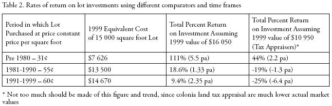
Table 2 suggests that in real terms, those absentee owners who bought prior to 1980 paid much less than those who came later —about half as much in some cases. For them it seems likely that the decision to buy early has resulted in a modest return. Assuming that an individual bought a lot of, say, 15 000 square feet at a constant price for the period of 31¢, at today's rates would mean an effective purchase price of $7 626. Comparing that amount with what contemporary residents self–assessed lots ($16 050) in their locality and or with tax appraisals ($10 950) for a similar sized piece of land, then that individual would have earned an approximate 110 percent or 44 percent increase on his investment over the twenty or more years respectively (see Table 2). But this only a 5.5 percent or 2.2 percent increase per annum over that period. Those who bought in 1980s (1.33 per cent per annum assuming 14 yrs) and 1990s (2.35 percent increase per annum over 4 years) would not have fared so well. Indeed, against appraised tax values they would have lost money.
Thus the important point for this discussion is that these rates of investment return are relatively low —derisory some might argue– certainly when measured against other forms of formal investment (CDs, blue–chip stocks, etc.), let alone against the rise in land values in other sectors of the real estate market over the years. However, it must be recognized that although they do not offer even a modest rate of return, buying into a colonia is one of the few (if only) opportunities for investment among the poor —given the relative ease of purchase, the low monthly rates, the virtually non–existent closing costs, etc., and the fact that other formal modes of investment are effectively closed to them. Nevertheless, there seems little doubt that for both absentee owners as well as for actual residents the sluggishness of the colonia land market as well as the lack of direct valorization of property values through mutual aid, self–help, and state–sponsored upgrading, in effect penalizes the poor and locks them out of benefits that many other social classes derive from property ownership. It is especially punitive to actual residents who struggle long and hard to improve their colonia and housing situation, and who leverage little more than the use value of their lots.
There is also the question of the capacity to sell one's home in the market. Much of the euphoria associated with Hernando de Soto's (2000) ideas on the benefits of property title and property ownership is predicated upon mobilizing one's home as equity against which to borrow, and/or the extra security that being able to sell one's home brings to vulnerable households. For such benefits to be actualized, however, one needs to be able to demonstrate the following: a) low–income people actively borrow against their home equity; and b) that there is a fluid market of lot and dwelling sales. In Latin American irregular settlements both are dubious assertions (Gilbert, 1999, 2001). Although lots often appear to sell freely in the earlier stages of settlement development, so called "consolidated" homes are less easy to sell on the open market. As Gilbert (1999) suggests, in effect a home may be "forever". Similarly, few low–income households seem well disposed to borrow against their housing asset, whether legalized or not. So much for the Mystery of Capital.
My data for Texas colonias suggests that the land market is "stunted", and that low–income homeowners in peri–urban settlements do not achieve the same benefits as do better off investors in upper and middle–income segments of the property market. Although realtor' signs in colonias are not unusual, they invariably look as though they have been in place for a long time, suggesting little effective movement. And, as we have observed above, the returns are modest, at best. My conclusion is that this segregation in quasi–formal homestead subdivisions, although offering genuine advantages to the poor, is both a facet of urban segregation, as well as an unwitting mechanism for reproducing inequality.
CONCLUSION
In this paper by drawing upon Latin American and US examples I have sought to demonstrate that there are various scales at which segregation should be unpackaged. At the macro level the lack of an apparent intensification in segregation levels is quite logical when tied to conditions of informality of land production processes on the one hand, and to a weak state/planning authority on the other. However, if we use an even broader optic and frame of reference to measure segregation that also includes the urbs in rure, namely rural settlement in the peri–urban areas (whether these be elite commuter sub–divisions or working class homestead settlements), then an intensifying urban segregation may become apparent —as I exemplify in the case of poor homestead subdivisions and colonias outside of US cities. Of course, adding–in this meta–urban scale may make no appreciable difference to overall segregation, but my point is that we should include the production and appropriation of the rural hinterland spaces in any analysis of that nearby city's residential mosaic.
At the micro level there seems little doubt, however, that lines are being drawn in the sand between neighborhoods. If higher order socio–economic groups cannot rely on either the market place or the state to inure them from their less well off or outright poor counterparts, then the rich groups will take matters into their own hands, by closing off streets, creating no–go access zones, and by barricading themselves behind high fences and armed guards. This may be undertaken ex–post, or deliberately planned for by developers as a commercialization tool. Although the trappings differ, middle and lower–middle income segments in the market place act similarly. Even the poor may do so, as in Santiago, Chile, through closing off a street behind chained gates so that residents may park their cars more safely outside their homes, and keep out undesirables (usually youth gang members). Whether for rich or poor populations, neighborhood exclusion practices and "walling out" harden the segregation lines at the local level, even if there is not appreciable difference in macro (city–wide) segregation patterns.
Finally, I have also demonstrated that land prices and market access may shape internal homogeneity of settlements and the propensity for movement between different segments of the market. Drawing upon survey data for a number of Mexican cities, this paper has demonstrated the ways in which the absolute price of land on the one hand, and degree of differentiation (price gap) between one segment of the market and the next one up or down, also shapes the 'hardness' of segregation between subdivisions, as well as their relative level of internal socio–economic heterogeneity or mixing. In general, when price differences are substantial between sub–segments, and where the cost of land for the poor is low and affordable, then little mobility is likely between segments. And, in these cases, with the exception of the bottom end of the market where many levels of the poor are trapped, internal homogeneity is the rule.
This segmentation of populations within respective land markets, and the reduced possibilities of making trade offs —say lot size or amenity of dwelling— by moving between segments is important. This is not only because it determines the relative hardness of social divisions between groups, but also because it help to reproduce inequality and stratification patterns in the urban arena. To the extent that certain segments of the market are more rapidly or more substantially valorized, so those locked–in or out will benefit, or will be left behind.16 As I hope I have demonstrated, this lower level of capital gain is particularly true in the case of Texas homestead subdivisions, notwithstanding the use–value benefits and advantages that their "sweat equity" strategy offers them. Ultimately they are slipping behind middle and upper income groups for whom the so–called "American Dream" is more likely to be in full Technicolor, rather than gray and white of low–income homestead settlements. In this sense segmentation reinforces stratification.
Even poor self–help settlements that comprise such a large part of the built up area in Latin American cities, and that are generally regarded as a rationale response to poverty may not be leveraging the capital gains of their own sweat equity to the extent formerly imagined. While lot and home sales are commonplace in the earlier phases of a settlement's development trajectory (when other poor are willing to buy–out earlier occupants) and do lead to significant profits against the social costs of living in an un–serviced and often illegal settlement, once consolidated (i.e. some 10–15 years later), the home and lot price are likely to be way beyond the range of other low–income would–be owners. Thus, there is no effective market for these homes, unless one is lucky enough to be bought out by a purchaser who wants to develop the lot for commercial purposes. As we have seen, some settlements are quite well located in what are otherwise middle income districts. Where this applies —as in Tlalpan in the south of Mexico City for example– then there is likely to be a more viable resale market, and better–off working classes and even middle–income households will be interested to buy–in and replace the dwelling with one more suited to their needs and lifestyle. But in the broad working class districts of Netzahualcóyotl in the east, or in Chalco (further east), the effective demand is likely to be minimal —thereby keeping prices low and penalizing (sweat) investors in that particular market.
Only by analyzing the way in which land markets are structured and function can we begin to better unpack our understanding of existing segregation patterns, as well as get handle on how accessibility to housing both reflects social inequality and may even lead to its intensification.
AKNOWLEDGEMENTS
I am grateful to the following for their constructive and close reading of the paper in an earlier form: Martim Smolka, Edith Jiménez and Peter Marcuse. The usual disclaimers apply.
REFERENCES
Amato, P. (1970), "Elitism and settlement patterns in the Latin American City", Journal of the American Institute of Planners, no. 36, pp. 96–105. [ Links ]
Aguilar, A. and P. Ward (2003), "Globalization, regional development, and mega–city expansion in Latin America: analyzing Mexico City's peri–urban hinterland", Cities, 20, 1, pp. 3–21. [ Links ]
Aliaga Linares, L. (2010), Unveiling the informal city a comparative analysis of the changing socio–spatial patterns of neighborhoods' underground economy in Lima and Bogotá, Doctoral dissertation in preparation, Department of Sociology at the University of Texas at Austin. [ Links ]
Alonso, W. (1960), "A theory of urban land markets", Paper and Proceedings of the Regional Science Association, no. 6, pp. 149–158. [ Links ]
Alvarado, A. (2000), "La Seguridad Pública", in Garza, G. (ed.), La Ciudad de México en el fin del segundo mileno, Departamento del Distrito Federal/El Colegio de México, México, pp. 410–419. [ Links ]
Berry, B. and J. Kasarda (1977), Contemporary Urban Ecology, Macmillan. [ Links ]
Boal, E (2001), Urban ethnic segregation and the scenarios spectrum", International Seminar on Segregation in the City, Lincoln Institute of Land Policy, Cambridge, Massachusetts, July 25–28. [ Links ]
Briceño León, R. (1999), "Violence and the right to kill: public perceptions from Latin America", International Research Workshop "Rising Violence and the Criminal Justice Response in Latin America: Towards an Agenda for Collaborative Research in the 21st Century, University of Texas at Austin, May 6–9. [ Links ]
Blakely, E. and G. Snyder (1995), Fortress America: gated and walled communities in the United States, Lincoln Institute of Land Policy. [ Links ]
Burgess, E.W. (1925), "The growth of the city", in Park, R. E., E.W. Burgess and R. D. McKenzie (eds.), The city: suggestions for investigation of human behavior in the urban environment, pp. 47–62. [ Links ]
Caldeira, Teresa Pires del Rio (2000), City of walls: crime, segregation and citizenship in Sao Paulo, University of California Press, Berkeley. [ Links ]
Clarke, C. (1966), "Population pressure in Kingston, Jamaica: a study of unemployment and overcrowding", in Transaction of the Institute of British Geographers, no. 38, pp. 165–182. [ Links ]
Clarke, C. (1971), "Residential segregation and intermarriage in San Fernando, Trinidad", Geographical Review, no. 61, pp. 198–218. [ Links ]
Clarke, C. (1983), "Urbanization", Chapter 7 in Dickenson, J. P. et al., A Geography of the Third World, Methuen, London and New York. [ Links ]
Clarke, C. (2006), Kingston Jamaica: urban development and social change, 1692–2002, Ian Randle Published, Kingston and Miami. [ Links ]
Clarke, C. and D. Howard (1999), "Color, race and space: residential segregation in Kingston in the late colonial period", Caribbean Geography, 10, 1, pp. 4–18. [ Links ]
Dalton, C. (1999), Being black, living in the red: race, wealth, and social policy in America, University of California Press, Berkeley & Los Angeles. [ Links ]
Davies, C. S. and R. Holz (1992), "Settlement evolution of 'colonias' along the US–Mexico border: the case of the Lower Rio Grande Valley of Texas", Habitat International, 16, 4, pp. 119–142. [ Links ]
De Soto, H. (2000), The Mystery of Capital, Basic Books. [ Links ]
Dowall, D. and M. Leaf (1991), "The price of land for housing in Jakarta", Urban Studies, no. 28, pp. 707–722. [ Links ]
Downs, R. and D. Stea (1977), Maps in minds: reflections on cognitive mapping, Harper and Row, New York. [ Links ]
Esquivel Hernández, M. T. (1995), "Dinámica socioespacial de la zona metropolitana de la ciudad de México y patrones de segregación 1980–1990", Anuario de Estudios Urbanos, núm. 2, pp. 297–315. [ Links ]
Flores, C. (2008), Residential segregation and the geography of opportunities: a spatial analysis of heterogeneity and spillovers in education in Santiago, Chile, Unpublished doctoral dissertation, The University of Texas at Austin. [ Links ]
Ford, L. (1996), "A new and improved model of the Latin American city structure", Geographical Review, 86, 3, pp. 437–440. [ Links ]
Fossett, M. (2006), "Ethnic preferences, social distance dynamics and residential segregation: theoretical explorations using simulation analysis", Journal of Mathematical Sociology, no. 30, pp. 185–274. [ Links ]
Gieryn, T. F. (2000), "A space for place in sociology", Annual Review of Sociology, no. 26, pp. 463–496. [ Links ]
Gilbert, A. (1999), "A home is for ever? Residential mobility and homeownership in self–help settlements", Environment and Planning A, 31, pp. 1073–1091. [ Links ]
Gilbert, A. (2001), "On the mystery of capital and the myths of Hernando de Soto" what differences does legal title make?", ESF/N–AERUS International Seminar on "Coping with Informality and Illegality in Human Settlements in Developing Cities", Leuven, 23–26 May. [ Links ]
Gilbert, A. and P. Ward (1985), Housing, the state and the poor: policy and practice in three Latin American cities, Cambridge University Press. [ Links ]
Griffin, E. and L. Ford (1981), "A model of Latin American city structure", Geographical Review, 70(4), pp. 397–432. [ Links ]
Harris, C. and E. Ullman (1959), "The nature of cities", in Mayer, H. M. and C. F. Kohn, Readings in Urban Geography, University of Chicago Press, Chicago, pp. 277–286. [ Links ]
Iceland, J. (2009), Where we live now: immigration and race in United State, University of California Press, Berkeley. [ Links ]
Janoschka, M. (2002), "The new model of Latin American city: fragmentation and privatization", EURE–Revista latinoamericana de Estudios Urbano Regionales, 27(85), pp. 11–29. [ Links ]
Jiménez, E. (2000), El principio de la irregularidad: mercado de suelo para vivienda en Aguascalientes, 1975–1998, Universidad de Guadalajara, Juan Pablos Editor, Centro de Investigaciones y Estudios Multidisciplinarios de Aguascalientes. [ Links ]
Johnston (1973), "Towards a general model of intraurban residential patterns. Some cross–cultural observations", in Board, C., R. Chorley, P. Haggett and D. Stoddart (eds.), Progress in Geography, 4, Edward Arnold, London, pp. 83–124. [ Links ]
Jones, G. (1998), "Resistance and the rule of law in Mexico", Development and Change, 26, 3, pp. 499–523. [ Links ]
Jones, G., E. Jiménez and P. Ward (1993), "The land market under Salinas: a real estate boom revisited?", Environment and Planning A, 25, pp. 627–51. [ Links ]
Jones, G. and P. Ward (eds.; 1994), Methodology for land and housing market analysis, University College London Press, London. [ Links ]
Jones, G. and P. Ward (1998), "The privatization of the commons: reforming the ejido and urban development in Mexico", International Journal of Urban and Regional Research. [ Links ]
Katzman, R and A. Retamoso (2005), "Spatial segregation, employment and poverty in Montevideo", CEPAL review, no. 85, pp. 125–141. [ Links ]
Larson, J. (1995), "Free markets in the heart of Texas", Georgetown Law Journal, 84 (December), pp. 179–260. [ Links ]
Larson, J. (2002), "Informality, illegality and inequality", Yale Law and Policy Review 2002, pp. 137–82. [ Links ]
Massey, D. and N. A Denton (1988), "The dimensions of residential segregation", Social Forces, 67, 2, pp. 281–315. [ Links ]
Marcuse, P. (2001), "Enclaves yes, Ghettos, no: segregation and the State", International Seminar on Segregation in the City, Lincoln Institute of Land Policy, Cambridge, Massachusetts, July 25–28. [ Links ]
Meng, G., G. B. Hall and S. Roberts (2006), "Multi–group segregation indices for measuring ordinal classes", Computers, Environment and Urban Systems, no. 30, pp. 275–299. [ Links ]
Mitchell, J. (1998), "Political decentralization: a new tool for the segregation of urban space? The Case of Chacao in Caracas, Venezuela", 1998 meeting of the Latin American Studies Association, Congress, September 24–26, The Palmer House Hilton Hotel, Chicago. [ Links ]
OAG (1993), Socio–economic characteristics of Colonia areas, White Paper, Office of the Attorney General, Austin, Texas. [ Links ]
OAG (1996), Forgotten Americans: life in Texas Colonias, Office of the Attorney General Texas. [ Links ]
Melvin L., O. and T. M. Shapiro (1997), Black wealth, white wealth: a new perspective on racial equality, Routledge, New York. [ Links ]
Pacione, M. (2001), "The internal structures of cities in the Third World", Geography, no. 86, pp. 189–209. [ Links ]
Peters, P. and E. Skop (2007), "The geography of poverty and segregation in Metropolitan Lima, Peru", Journal of Latin American Geography, 6, 1, pp. 149–171. [ Links ]
Peters, P. (2009), Spatial segregation in complex urban systems: housing and public policy in Santiago, Chile, Unpublished doctoral dissertation, The University of Texas at Austin. [ Links ]
Rubacalva, R. M. and M. Schteingart (1987), "Estructura urbana y diferenciación socioespacial en la zona metropolitana de la ciudad de México (1970–80)", in Garza, G. (ed.), El atlas de la Ciudad de México, Departamento de Distrito Federal/El Colegio de México, México, pp. 108–115. [ Links ]
Rubalcava, R. M. and M. Schteingart (2000), "Segregación socioespacial", in Garza, G. (ed.), La Ciudad de México en el fin del segundo milenio, Departamento del Distrito Federal/El Colegio de México, México, pp. 287–296. [ Links ]
Paul, R. (1965), Urbs in rure: the Metropolitan Fringe in Hertfordshire, Longman. [ Links ]
Reardon, S. F. and G. Firebaugh (2004), "Measures of spatial segregation", Sociological Methodology, 34, 1, pp. 121–162. [ Links ]
Richardson, Ch. (1999), Batos, bolillos, pochos, y pelados: class and culture on the South Texas Border, UT Press, Austin. [ Links ]
Robson, B. (1973), Urban growth: and approach, Methuen, London. [ Links ]
Sabatini, F. (1998), "Urban land prices and spatial segregation: the case of Santiago, Chile", 1998 meeting of the Latin American Studies Association, Congress, September 24–26, The Palmer House Hilton Hotel, Chicago. [ Links ]
Sabatini, F. (2001), "Residential segregation pattern changes in main Chilean cities: scale shifts and increasing malignancy", International Seminar on Segregation in the City, Lincoln Institute of Land Policy, Cambridge, Massachusetts, July 25–28. [ Links ]
Sabatini, F. (2006), The social spatial segregation in cities of Latin America, Washington D.C., The Interamerican Development Bank (IADB) Sustainable Development Department, Social Programs Division. [ Links ]
Schnore, L. F. (1965), "On the spatial structure of cities in the two Americas", in Hauser, P. and L. Schnore (eds.), The Study of Urbanization, John Wiley, New York, pp. 347–398. [ Links ]
Siembieda, W. (1994), "Measuring the price and supply of urban land markets: insights on sources", in Jones, G. and P. Ward (eds.), Methodology for land and housing market analysis, University College London Press/ Lincoln Institute for Land Policy, pp. 146–158. [ Links ]
Timms, D. (1971), The urban mosaic; towards a theory of residential differentiation, Cambridge UP. [ Links ]
Ward, P. M. (1993), "The Latin American inner city: differences of degree or of kind?", Environment and Planning A, 25, pp. 1131–1160. [ Links ]
Ward, P. M. (1998), Mexico City, Second Revised edition, Wileys, revised and translated in 2004, México, Megaciudad: desarrollo y política 1970–2002, El Colegio Mexiquense, Miguel Ángel Porrúa, México. [ Links ]
Ward, P. M. (1999), Colonias and public policy in Texas and Mexico, University of Texas Press. [ Links ]
Ward, P. M. (2001), "Dysfunctional residential landmarkets Colonias in Texas", Landlines, 13, 1, pp. 4–7. [ Links ]
Ward, P. M. (2004), "Informality of housing production at the urban–rural interface: the not–so–strange case of colonias in the US: Texas, the border and beyond", in Annanya, R. and N. AlSayyad (eds.), Urban Informality, Lexington/Center for Middle Eastern Studies, UC Berkeley, pp. 243–270. [ Links ]
Ward, P. M., Jiménez and G. Jones (1994), "Measuring residential land price changes and affordability", in Jones, G. and P. Ward (eds.), Methodology for land and housing market analysis, University College London Press/Lincoln Institute for Land Policy, pp. 159–178. [ Links ]
Ward, P. M. and J. Carew (2000), "Absentee lot owners in Texas colonias: who are they, and what do they want?", Habitat International, no. 24, pp. 327–345. [ Links ]
Ward, P. M. (in collaboration with Stevenson, R. and A. Stuesse) (2000), Residential land market dynamics, absentee lot owners and densification policies for Texas Colonias, An LBJ School of Public Affairs Policy Report. [ Links ]
Ward, P. M. and P. Peters (2007), "Self–help housing and Informal Homesteading in Peri–Urban America: settlement identification using digital imagery and GIS", Habitat International, pp. 141–164. [ Links ]
Wilson. W. J. (1987), The truly disadvantaged: the inner city, the underclass, and public policy, University of Chicago Press. [ Links ]
1 In contrast with "Urbe in Rure" described by Ray Pahl (1965) in his classic study of London urbanites lining in commuter villages.
2 It can also work the other way, of course. Marcuse (2001) points out that public sector urban renewal programs, housing project development, transportation policy providing for "flight", have exacerbated ethnic segregation problems in US cities.
3 Also, we found evidence for non–monetary considerations to enter the negotiation process relating to land transactions among the poor. Sometimes this included another good in part–exchange (car, a gas cooker and in one a case a suit of clothes!).
4 It seemed likely that Salinas' 1993 reform of Article 27 of the Constitution which made possible the privatization of the ejido would dramatically shape land prices trends in this particular segment of the market. Certainly one would have expected prime ejidal land to be open to middle income and elite residential sub–divisions in ways that were not possible before. However, subsequent analysis (Jones, 1998; Jones and Ward, 1998) suggest that was not happening on any appreciable scale.
5 For reasons of brevity, methodological and data management issues related to this analysis are not described here. See Ward et al., 1994:160–164 for specific details. Also, Siembieda (1994) for a review of different sources of land price information and for "multiple sourcing" techniques.
6 He defines Quartering as the division of urban space into quarters created by the operation of the private market in real estate and housing, based on the income or wealth of households.
7 The marked heterogeneity of households and dwelling improvement levels in low income irregular settlements is a widely noted feature.
8 Of course other things often are not equal since racial or ethnically produced segregation processes may reduce this mobility. Red lining would be one example, association ordinances demanding every larger lot sizes (and therefore costs) or prohibitions upon smaller home sizes, rental subdivision, etc.
9 We explain the lower absolute cost of land in Querétaro as primarily an outcome of the historical weakness of ejidatarios and their allied interest groups (the CNC) in that city, and the relative strength of the 'popular' sector (the CNOP/UNE). This balance of forces meant that the PRI enjoyed good and relatively un–conflictive relations with the irregular settlements, and the state and municipal governments had far greater success in achieving land regularization and servicing program than was the case in either Puebla or Toluca where peasant groups proved to be better able to resist state interventions that threatened to undermine the land development interests of their followers (the ejidatarios).
10 Questions arise about causality here. Does the (social) price setting mechanism by land producers create segregation, or do exogenous price trends and the relative affordability of segments of the market confer a greater propensity for segregation? My own belief is that it can be both. The social production of land is crucial, but it is often not readily articulated, not least in informal and weak local state conditions that apply in Latin America. Here the nature of segmented land markets can, of itself, create or reduce segregation and internal heterogeneity.
11 The median annual household income for a typical colonia household of 5–6 people is $7 000 to $11 000 (SMA Data Book, cited in Larson, 2002:19). The federal government considers a family of five to be living in poverty if the annual household income is less than $19 520 and $22 340 for a family of 6 (Federal Register, vol. 64, 52, March 18, 1999, 13428–13430). Average per capita incomes in some of the border countries in 1997 were as follows: $12 857 FOR Cameron; $12 005 for Hidalgo; $12 999 for Webb (Laredo, the second fastest growing city in the nation), El Paso $15 216. Of course, per capita incomes are considerably lower in colonias.
12 The focus of a workshop at the Lincoln Institute of Land Policy, Cambridge, Massachusetts, September 20–23, 2001.
13 Elsewhere in the US recent research has argued that certain racial groups are systematically disadvantaged by their lesser opportunities to mobilize human and social capital investments, and that this plays a significant role in reproducing enduring class divisions along racial lines; see Melvin and Shapiro (1997), Danton Conley (1999).
14 A varying width fringe area beyond the city boundary over which the city can exercise development rights of annexation etc.
15 In the border most of the industrial employment is undertaken by Mexican workers in the maquila industries in Mexico 'twin' cities.
16 This assumes a generally upward trend, of course; if the market drops then certain groups may be more exposed to the problems of negative equity than others.

