


Servicios Personalizados
Revista
Articulo
 Inglés (pdf)
 Artículo en XML
 Referencias del artículo
 Enviar artículo por email
Indicadores
-
 Citado por SciELO
 -
 Accesos
Links relacionados
-
 Similares en
SciELO
Similares en
SciELO
Compartir

 Permalink
Investigaciones geográficas
versión On-line ISSN 2448-7279versión impresa ISSN 0188-4611
Invest. Geog no.55 Ciudad de México dic. 2004
Geografía física
Impact of land-use changes on the climate of the Mexico City Region
Impacto del uso del suelo en el clima de la Ciudad de México
Ernesto Jáuregui*
* Center Atmospheric Sciences, National University (UNAM), Cd. Universitaria, 04510, Coyoacán, México, D. F. Email: ejos@atmosfera.unam.mx
Recibido: 17 de junio de 2004
Aceptado en versión final: 21 de septiembre de 2004
Abstract
It is well established that anthropogenic land-use changes directly affect the atmospheric boundary layer at the mesoscale dimensions. Located in the high lands of Central Mexico, the basin of Mexico (7 500 km2) has undergone a widespread conversion of natural vegetation to urban and agricultural land by deforestation. While the urban extension of the capital city occupied 6% of the basin in 1960, at the end of the twentieth century the urban sprawl had increased considerably to 20% of the total area. This phenomenal growth has impacted on the thermal climate of substantial portions of the basin. In this paper using annual temperature and precipitation data for a 25 year period, an attempt is made to identify interdecadal climate changes. Results show that large areas of the basin have changed toward a warmer drier climate. While afternoon temperatures have increased at a rate of 0.07° C/yr in the suburbs of the city the corresponding area averaged value for the rural sites is somewhat less: 0.06° C/yr. The afternoon temperature increase for the total number of stations used was 0.06° C/yr. The area-averaged minimum temperature increase in suburban stations (3) was 0.15° C/yr while that corresponding to surrounding rural sites was 0.08° C/yr for period 1961-1985.
This last result illustrates the relevant role the heat island phenomenon has had in changing the thermal climate as compared with that observed in the rural environment.
Key words: Climate change, land-use changes, urbanization, deforestation, precipitation trend.
Resumen
Es conocido el hecho de que los cambios de uso del suelo tienen un impacto directo en la capa planetaria alterando el régimen de temperatura y precipitación a escala local. Ubicada en el altiplano central del país, la cuenca de México (7 500 km2) ha sufrido una intensa conversión de la vegetación natural por áreas agrícolas o urbanas mediante la deforestación. Para dar una idea de dichos cambios, la capital del país ocupaba en 1960 un 6% del área de la cuenca mientras que al finalizar el siglo XX la extensión de la urbe era ya del 20% de la superficie total. Este incremento fenomenal del área urbanizada ha impactado el régimen termal en grandes porciones de la cuenca. Utilizando datos de temperatura y precipitación para un periodo aproximado de 25 años, en este trabajo se intenta documentar los cambios climáticos interdecadales inducidos por las modificaciones del uso del suelo. Los resultados muestran que en extensas áreas de la cuenca las temperaturas máximas anuales mantienen una tendencia positiva (de 0.07° C/año). Este contraste se hace más marcado cuando se utiliza la temperatura mínima donde en sitios suburbanos el incremento promedio por áreas es 0.15° C/año mientras que en áreas rurales el cambio correspondiente es casi la mitad (0.08° C/año) para el periodo 1961-85. Este resultado ilustra el mayor impacto que ha tenido el fenómeno de la isla de calor en el cambio climático observado en comparación con el correspondiente al ámbito rural.
Palabras clave: Cambio climático, cambio de uso del suelo, urbanización, tendencia de la temperatura.
INTRODUCTION
Previous investigations in various geographical regions have shown that landuse changes at the regional scale have altered the local rainfall and temperature patterns (Pielke et al., 1999). During the second half of the twentieth century the Mexico City Basin has undergone a widespread conversion of natural vegetation on the plains (as well as at the piemont of mountains surrounding the basin) to urban and agricultural land by deforestation. While reducing the moisture sources these changes have caused a large portion of the available solar radiation to be used for heating the air and therefore the impact has been toward a warmer and drier climate. In this paper an attempt is made to detect temperature changes at the decadal scale that may have occurred in the basin and their possible cause.
GEOGRAPHICAL SETTING AND CLIMATE
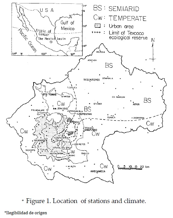
Mexico City is located in an elevated (2 250 masl) inland basin in central Mexico in the tropics (19Q20'N) covering an area of 7 500 km2 (Figure 1). The basin of Mexico encompasses parts of the states of Tlaxcala, Hidalgo, Puebla, Mexico and the Federal District. Mexico City and its conurbation concentrates 95% of the total population of the basin (Valverde and Aguilar, 1987).
The basin of Mexico is not a continuous unit. Different geological origins, soil composition and climates determine a mosaic of environments frequently characterized by different vegetation types (Ezcurra et al., 1999).
Volcanic ranges surround the lacustrine plains on the east, south and west. To the north the basin is bounded by discontinuous ranges. The main forests occupy the upper piedmont above 2 500 m to the west (Serranía de las Cruces) south (Ajusco) and east (Sierra Nevada) and harbor temperate plant communities of pines, fir and junipers (Figure 2). The vegetation of the basin has been throughly described by Rzedowski, 1975; Sanders 1976. See also a short description in Ezcurra et al. 1999. On the semiarid plains, chaparral and shrub vegetation occur and salt resistant vegetation prevails in the lower parts of the basin, mostly on the beds of ancient lakes (eg. Texcoco) that now remain dry during winter and spring. This is the area located on the eastern city limits where a land reclamation project named Plan Texcoco has been set up since the 1970's. Part of the project consisted in the construction of a lake (~1 000 ha) and repasturization of around 8 000 ha. Among the benefits to the environment are the considerable reduction of dust storms that plagued the city at the end of the dry season and an increase in the humidity on the eastern suburbs (Jáuregui, 1971; 1989; 1990/91). As a result of growing occupation of agricultural land by urban expansion, the proportion of the basin land used for agriculture and cattle raising has decreased. In spite of the above, traditional agriculture still occurs in the southeast and to the north. Around the small scattered settlements in the basin, especially to the south where the more humid temperate climate prevails, different varieties of corn are still harvested in addition to chili and squash, oats, tomatoes, beans, potatoes, agaves and opunti (in southern Milpa Alta; Ezcurra et al., 1999). Also native fruit such as Crataegus mexicana (tejocote), Prunus capulli (capulin; García-Mora 1978, 1979; Pisanty, 1979).
The southern districts of Tepetlixpa, Atlautla, Nepantla and Ecatzingo where rainfall is more abundant are important producers of fruit such as apricots, pears, apples, peaches plenis and avocadoes (Ezcurra et al., 1999). These authors mention the harvest of agricultural weeds as food supplements following the traditional usage of Aztec agriculture. Some weeds are edible and others are used in traditional medicine and most of them are harvested as fodder for domestic animals. However, agricultural land use is fast disappearing (at an annual rate of decrease of 7.4%) in their extent and agropastoral fields have almost disappeared, (Ezcurra and Mazari, 1996).
The climate
Mexico lies in the tropics/subtropics therefore is under the influence of both tropical air masses during summer (May-Oct.) and the midlatitude cold air masses from North America during winter.
The climate in the study area is semiarid (BS) on the central plains and northern portions with annual precipitation ranging from 550 to 600 mm while to the west, south east and south the climate is more humid (Cw) where rainfall increases to 1000-1300 mm/yr near the water-shed. Figure 1 shows distribution of climate types.
THE URBANIZATION DEVELOPMENT
During the period 1960-1990 for which temperature/precipitation data were available the urban area added to the city was 834.7 km2. The city had experienced its highest growth rate during the 1970's when an area of 397 km2 of urbanized land was added to the capital city mainly toward the north and east. The population rate of growth declined in the city in the following decade (the 1980's) to 2.28 million per decade (especially after the 1985 earthquakes). The population of the metropolis at the end of the XXth century was 17.95 inhabitants, an increase of 4.96 million inhabitants with respect to 1980. While in 1960 Mexico City and its conurbation covered 470.7 km2 by the end of the 1980's it expanded to around 1 305.4 km2, an increase of 834.7 km2 (Table 1).
It is only to be expected that this tremendous rate of substitution of natural landscape into urban elements from 1960 until the end of the XXth century (in addition to the increased deforestation) have gradually changed the local climate of the basin. These dramatic land-use changes can be visualized at a glance of landuse maps of the basin for 1976 and 2000 shown in Figure 3.
Urban-induced temperature changes
It is well established that the urbanization process affects the partitioning of water and energy fluxes in the urban boundary layer resulting in a dominance of heat and net storage fluxes that lead to higher urban temperatures. Aspects of space and time variations of Mexico City's heat island have been documented by the present author (Jáuregui, 1986, 1993, 1997, 2000). The urban/rural minimum temperature contrasts have increased their intensity from 1.2° C at the end of the 19th century to around 9° C in the early 1980's as the urbanization grew from 27.14 km2 to 1 150 km2 during the same period. The mean annual temperature over this period has augmented at the rate of 2° C/100 years (Jáuregui, 1986). The warming rate averaged over all stations (31 named in Figure 1) on the plains (some on the piedmont) of the basin was 0.49° C/decade. This rate of increase is more than twice the global warming as estimated for the tropics by WMO (WMO-No.920).
Urban-induced precipitation
A considerable number of studies have suggested that large urban areas induce changes in rainfall (Kratzer, 1956; Landsberg, 1956, 1970; Chagnon and Huff, 1986). Jáuregui and Romales 1996, have attempted to find evidence of Mexico City urban-induced increases in convective precipitation using daily and seasonal precipitation. In their paper 24-hour isoye-tal analysis showed the existence of not infrequent one or several cells of maximum precipitation located near or downwind of the heat island; moreover, they were able to show that the frequency of intense rain showers (>20 mm/hr) had increased five-fold from 4 per decade in the 1940's to 20 per decade in the 1980's as shown in Figure 4. These authors also found a significant positive trend of the May-October precipitation series for urban station Tacubaya for period 1940-85. However analysis applied to the rest of pluviometric stations in the basin showed trends to be below the 90% level of significance. Therefore in this paper discussion of trend analysis is limited to the maximum/minimum temperatures series showing significant trends above 90%.
METHOD
Using mean monthly and annual temperature data for 21 stations in the Mexico Basin (see Figure 1 for location) for period 1961-1985, an attempt is made to show that increasing urbanization/deforestation may be at the origin of an increase in morning and afternoon temperatures observed during the period mainly on the southern portions of the basin.
RESULTS
Temperature trend
The maximum temperature
Figure 5 shows distribution of the mean maximum annual temperature trend in the Mexico Basin (° C/century). Afternoon temperatures have increased on the central plains and to the northeast to the east where urbanization is minimal but agricultural activities may have augmented thus turning the albedo of agricultural lands toward higher values during the dry season. A marked area of positive values is centered over Mexico City where the urbanization effect (e.g. heat island) is dominant. The area of negative trend to the east and west of the capital city could be explained by the combined effect of the interception/absorption of solar radiation and increase in albedo of the air pollution layer over the years. Positive decadal variation of mean annual maximum temperature and trend are shown in Figure 6a for selected rural stations on the plains of the Mexico basin and away from the influence of the city, these trends are significant to levels above 90% (see Table 2). Figure 6b shows negative maximum temperature trends for those stations located in the vicinity of the capital city but somewhat distant from the heat island effect and where the smog layer increase in albedo might be dominant (see Figure 1 for location) thus tending to reduce afternoon temperatures.
The minimum temperature trends
Figure 7 shows interdecadal variability of mean annual minimum temperatures for selected suburban (Tacubaya)/rural stations in the basin (see Figure 1 for location). All stations (8) show a positive trend (significant level >95%) suggesting that morning temperatures are getting warmer not only in the realm of the large metropolis (due to the urban heat island) e. g. urban /suburban stations Egipto, Moyoguarda and Calacoaya) but also in the rural areas surrounding the capital city (Table 3) due to the increasing absorption of outgoing long wave radiation of the surface by the smog layer, which has become denser over the years. While the Tmin trend for the suburban stations (3) shows an average of 0.15° C/yr that corresponding to the rural sites is considerably lower: 0.08° C/yr. The area average maximum temperature trend for suburban stations (6) is 0.07° C/yr while that corresponding to the rural areas (represented by 8 stations) is slightly lower: 0.06° C/yr (see Table 2). The area-averaged minimum temperature increase for all stations was 0.11° C/yr.
DISCUSSION
The potential impacts on climate of deforestation/urbanization in a large (7 500 km2) tropical basin are examined. The Mexico Basin has experienced drastic land use changes due to urbanization/deforestation especially during the second half of the XXth century. Anthropogenic activity such as changes in landscape to agricultural and grazing areas have also contributed to changes of climate on the regional scale. These changes affecting the partitioning of water and energy seem to have caused an increase in maximum temperature not only in the large conurbation where the heat island is located (Jáuregui, 1997; 1993) but also in extensive areas of the semiarid plains to the NE where deforestation and agricultural practices seem to have changed the incoming energy partitioning toward a warmer climate. The destruction of plant cover reduces the shading of the soil surface thus increasing the availability of energy to heat the air and in addition accelerating runoff due to less interception of rain water. As a consequence soil moisture levels are likely to decrease resulting in more energy being available to heat the soil and air (sensible heat) than to evaporate the water (latent heat). This increase in temperature would lead to a cycle of drying. The warming of the climate is also evident in the positive trend shown by the morning temperatures in urban stations under the influence of the heat island but also manifest in rural areas distanced from the city where it is likely that the dominant impact is the increasing density of the smog layer acting as a screen to the surface outgoing long-wave radiation in the morning hours. On the other hand (although trend tests show a low 75% level singnificance) precipitation on the plains of the basin seems to have declined as well as on the forests to the south. These results seem to be in agreement with the hypothesis that the observed land use changes (urbanization/ deforestation) have impacted in the direction of a warmer and drier climate in the Mexico Basin. Even though results of the analysis seem logical in some instances (eg. positive afternoon temperature trends over the city and its surroundings due to the increasing heat island effect) as the city grew in extension, similar positive temperature trends are also observed on the semiarid northeast corner of the basin and on the forested areas to the south. These positive trends could be explain-ned by the increasing grazing (on the northeast) and to clearing due to logging on the elevated forests of the south. However data on such land-use changes are not available to support this hypothesis.
Since maps of vegetation cover for the Mexico Basin are only available for 1976 and 2000 it is not possible to estimate vegetation changes that occurred during the whole period for which climatological data were available. It is unfortunate that the network of climatological stations was drasticaly reduced after the mid-eighties so that it was not possible to extend the temperatures/precipitation trends up to the 1990's when urbanization/ deforestation continued at an accelerated rate.
ACKNOWLEDGMENTS
The author is grateful to Elda Luyando and Mario Casasola for processing data, to Alfonso Estrada for doing the maps. Gabriela Gómez from de Institute of Geography elaborated the land use maps provided by INEGI.
REFERENCES
Cardoso, D. y E. García. (1982), "Vegetation and climate in the Mexico Basin", in Proceed. Latin American Regional Conf. IGU, Brazil, Geographical Topics of Mexico City, pp. 19-25. [ Links ]
Chagnon, S. A. and F. Huff (1986), "The urban-related nocturnal rainfall anomaly at St Louis", J. Climate Appl. Meteorol., 25, 1985-1995. [ Links ]
Ezcurra, E. and M. Mazari (1996), "Are megacities viable? A cautionary tale from Mexico City", Environment, 38, 1, 6-15:26-35. [ Links ]
Ezcurra, E., M. Mazari-Hiriart, I. Pisanty and A. Aguilar (1999), "The basin of Mexico. Critical and environmental issues and sustainability", United Nations University Press, J. Kasperson, R. Kasperson and B. Turner (eds.), pp. 12-22. [ Links ]
García-Mora, C. (1978), El medio y los barranqueríos en San Miguel Atlanta, Informe CISINAH, México. [ Links ]
García-Mora, C. (1979), "Notas sobre la antropología ecológica de la subcuenca Chalco", Biótica, 4, 1, pp.13-22. [ Links ]
Garza, G. (coord.; 2000), Ámbitos de la extensión territorial. La Ciudad de México en el fin del segundo milenio, GDF/Colmex, pp. 237-246. [ Links ]
Jáuregui, E. (1971), "Soil erosion by wind in the dry plains of exlake Texcoco", Ingeniería Hidráulica en México, vol. 25, 2, pp. 103-117. [ Links ]
Jáuregui, E. (1986), "The urban climate of Mexico City", in Oke, T. (ed.), Proceedings of the WMO Technical Conference on Urban Climate, WMO, no. 652, pp 63-86. [ Links ]
Jáuregui, E. (1989), "The dust storms of Mexico City", Int. J. of Climatology 9, pp. 169-180. [ Links ]
Jáuregui, E. (1990/91), "Effects of revegetation and new artificial water bodies on the climate of NE Mexico City", Energy and Buildings, 15-16, pp. 447-455. [ Links ]
Jáuregui, E. (1993), "Mexico City's heat island revisited", Erdkunde, 47, pp. 185-195. [ Links ]
Jáuregui, E. and E. Romales (1996), "Urban effects on convective precipitation in Mexico City", Atmos. Environment, 30, 20, pp. 3383-3389. [ Links ]
Jáuregui, E. (1997), "Heat island development in Mexico City", Atmos. Environment, 31, 22, pp. 3821-3831. [ Links ]
Jáuregui, E. (2000). El clima de la Ciudad de México, Col. Temas Selectos de Geografía de México (I.4.1), Instituto de Geografía/Plaza y Valdés, México. [ Links ]
Kratzer, A. (1956), "The climate of cities", Am. Met. Soc. [ Links ]
Landsberg, H. (1956), The climate of towns. Man's role in changing the face of the earth, University of Chicago Press, pp. 584-603. [ Links ]
Landsberg, H. (1970), "Man-made climatic changes", Science, 170, pp. 1265-1274. [ Links ]
Lowry, W. (1998), "Urban effects on precipitation amounts", Progress in Physical Geography, 22, 4, pp. 477-520. [ Links ]
Pielke, R., R. L. Walko, L. Steyaert, P. Vidale, G. Liston, W. Lyons and T. Chase (1999), "The influence of anthropogenic landscape changes on weather in South Florida", Mo. Wea. Review, 127, pp. 1663-1673. [ Links ]
Pisanty, I. (1979), Introducción al estudio de los ecosistemas transformados en el área Chalco-Amecameca: el maíz, Unpublished thesis, Facultad de Ciencias, UNAM, México. [ Links ]
Rosenfeld, D. (2000), "Suppression of rain and snow by urban and industrial air pollution", Science, 287, pp. 1793-1796. [ Links ]
Rzedowski, J. (1975), "Flora y vegetación de la cuenca del valle de Mexico", en Memoria de las obras del Sistema de Drenaje Profundo del D.F., vol. I, Talleres Gráficos de la Nación, México, pp. 79-134. [ Links ]
Sanders, W. T. (1976), "The natural environment of the Basin of Mexico", in ER (ed.), The valley of Mexico: studies in prehispanic ecology and society, University of New Mexico Press, Albuquerque, pp. 59-67. [ Links ]
Valverde, C. and A. G. Aguilar (1987), "Localización geográfica de la Ciudad de México", en Garza, G. (ed.), Atlas de la Ciudad de México, P.D.F. y Colegio de México, México. [ Links ]
WMO (2001), WMO statement on the status of the global climate in 2000, WMO No. 920, Geneva. [ Links ]

