


 nueva página del texto (beta)
 Inglés (pdf)
 Artículo en XML
 Referencias del artículo
 Enviar artículo por email
 Citado por SciELO
  Similares en
SciELO
Similares en
SciELO 
 Permalink
Introduction1
This article forms part of the literature about urban agglomerations at national borders, which examines the social, demographic, spatial, and economic processes in the urban border area (Bustamante, 1989; SELA, 2011). The border is not only a limit on national sovereignty, but an territory that makes up portions of two or more states, in which activities are developed that simultaneously affect cultural, economic, social, and environmental dimensions of each border country (Grimson, 2000; Garduño, 2003; Bartolomé, 2005; Newman, 2003; OIM, 2012).
Borders nowadays are not only influenced by interactions that take place on a local scale, but by processes on a global scale, multilateral relations, and political decisions on national and regional scales (Carrión, 2013; Perrier, 2013). In this sense, urban border agglomerations articulate with the networks of the global economic system under a framework of local conditions. Also, the agglomerations' sociospatial dynamics operate like nodes for the f low of goods, persons, and information. They also operate under the dynamics of territorial localization of activities, within legal, illegal, and criminal markets (Castells, 1999).
In Latin America, the literature about these issues has emphasized two types of study: the border between Mexico and the United States, and-to a lesser extent-the triple border between Brazil, Paraguay, and Argentina. The first case has given rise to discussions in relation to what Herzog (1990) called cross-border metropolises.2 The triple border has received particular attention due to the informal economic activities that are established there, and its important population growth through investment in infrastructure in the zone (García, 2014).
This article addresses the case of the conurbation of the cities of Zarumilla and Aguas Verdes, located in the department of Tumbes, on the northern Peruvian coast, and their interrelation with the Ecuadorian city of Huaquillas. The importance of this case lies in the transformations the border zone has experienced in recent decades in its socioeconomic and territorial dimensions. It has changed from being a border characterized by military tensions between Peru and Ecuador throughout the 20th century to an open border or one of greater porosity as a result of the signing of a definitive peace treaty between both countries in the 1990s.3
The peace process was preceded by three armed conflicts (1941, 1981, and 1995); all this was resolved with the signing of the Acta de Brasilia [Brasilia Protocol] in 1998 (Congreso de la República del Perú, 1998). Also signed was a series of treaties seeking to help create the conditions for the border area between both countries to adapt to the requirements of the globalized world (Hocquenghem and Durt, 2002). Another important occurrence-which took place before the end of the armed conflict between both countries-was the creation of the district of Aguas Verdes in 1985, which involved dividing the territory of the district4 of Zarumilla in two and a greater independence for the management of the border area closest to the dividing line. The aim of this work is to analyze how, in the framework of these processes, there have been changes in the dynamics of settlement and in how the Peruvian population has become attracted to the border area. Also, it is interesting to see how these transformations occur in the daily and seasonal activities of the population, in the sense that the border conurbation functions as one urban system.
This article is organized into four sections. First, it discusses the literature about borders, and in particular about border cities. Second, it describes the methodology used in the research, taking note of the scope and limitations of this work. Third, it presents three axes of analysis: 1) the formation of the district of Aguas Verdes and the Peruvian-Ecuadorian peace process, tied to urban expansion and border conurbation, 2) the population growth of the districts of Zarumilla and Aguas Verdes, and the reasons the border zone became attractive, and 3) the daily and seasonal dynamics of mobility between the border cities. Finally, some conclusions about the main dynamics that characterize this territory are presented.
The border conurbations in the context of globalization
The understanding of the new territorial dynamics in border areas requires a mul-tiscalar approach, which takes into account the relationships between different actors and their logics of action, as well as the main processes on a global scale that have affected the dynamics and the ways of understanding borders. This allows discussion of border urban agglomerations that places emphasis on how the specialized literature has been addressing the study of the f lows of persons and goods associated with the processes of urbanization and conurbation at borders.
In the last two decades, the research on borders has stopped referring to them as a boundary area of the nation-state and rather addresses them as a space and territory of articulation of human activities on different scales (Newman, 2003). This appears to have overcome what van Schendel (2005) and Perrier (2013:3-4) have called "the territorial trap"; that is, conceiving of the borders as spatial limits of the states, which involves a series of biases that hinder the understanding of the particularities of these zones. To the contrary, borders are recognized as territories with their own dynamics influenced by political decisions and dynamics of formal and illegal markets that articulate with the local, national, and international scale (for the committed adjacent countries) as well as the global one.
The borders are characterized by a certain spatial stability, but also are subject to variations over time, which are the manifestation of new forms of territoriality (Perrier, 2013). In recent decades, these new forms of territoriality are associated with the characteristics that the globalization process adopts (Bradshaw and Linares, 1999; Ramírez, 2008; Carrión, 2013; Perrier, 2013), and that involve the articulation of border spaces with global systems (Carrión, 2013). In general, two types of articulation between borders and global processes predominate. On the one hand, globalization has involved the articulation of borders with global networks and also has served as a node for some legal, illegal, and criminal markets (Castells, 1999). On the other hand, as Brenner (1999) suggests, globalization has meant spatial reorganization at different scales of the socioeconomic and political-administrative dimensions inside and outside the nation-state. This has translated into a process of decentralization, in which local governments assume an essential role in attracting and managing global economic flows. In other words, processes at the subnational scale, such as the articulation of cities with cross-border networks, occur within the dynamics of globalization (Sassen, 2007).
Nevertheless, the processes that affect borders do not all happen in the same way. This is seen with greater clarity depending on the territorial scales of analysis. A way of establishing different scales of analysis for the border is to consider the following typology: 1) border strip, the smallest unit closest to the border line, 2) border zone, which is the border conurbation, and 3) border regions, the broad territory articulated to the border areas and strips (OIM, 2012). But the scales also can refer to the political-administrative units, which involve the design of policies with scopes and interests defined by the level of government, namely, international, national, regional, and local (Brenner, 1999; van Schendel, 2005; Perrier, 2007).
Also, the physical manifestations of these new forms of territoriality are not always the same, and they are conditioned by topographical, historical, and political characteristics, and by the border's own dynamics. To differentiate between them, the Latin American and Caribbean Economic System (SELA, 2011) proposes a typology of border situations, using variables such as the type of area settled (urban or rural), socioeconomic characteristics of the population that occupies it (native, peasant, or urban communities) and by the level of interrelationship between the residents on both sides of the border (for example, borders under construction or consolidated ones). To this are added border situations in which the boundaries have become porous-the national limits are crossed without issue for f lows of commerce, persons, and information-and closed borders, where the military presence or control has hardened or been maintained (Garduño, 2003; Newman, 2003; SELA, 2011; García, 2014).
In this framework, urban areas have increasingly become an important dimension for the study of borders (Dilla, 2015). There are various concepts that have been used to capture the main characteristics of this dimension. Dilla (2015), for example, coined the concept of urban cross-border complexes to refer to territories with similar environmental characteristics and a high level of spatial articulation, to which is added economic interdependence, strong primary relationships between residents on both sides of the border, and institutional relationships, among other characteristics. Another common concept in these works is that of binational cities (Ehlers and Buursink, 2000), referring to territories with cultural, historic, and social unity, but divided by national limits. Similar to this last example is the concept of international cities, utilized by Chiarella (2005) to refer to urban agglomerations, which include portions of territory of different countries whose dynamics make joint public management necessary or possible.
One of the concepts that has generated greater debate is that of cross-border metropolises, coined by Herzog (1990), utilized by authors such as Sohn (2014), and which refer to urbanized areas on both sides of the border line whose connection is established by the daily activities of the residents and natural resources, among other characteristics.5 A last example is that of border cities, utilized, among other authors, by Vergel-Tovar (2008), defined by settlements at a point of encounter of two or more countries, where the settlements are far from the centers of decision-making of each country. In terms of the review of these proposals, this work utilizes the term border city to refer to an urban settlement close to or even far from the boundaries of a nation-state where there are dynamics of intensive economic f lows and those of persons and goods with the closest city on the other side of the border.
In relation to the above, it is important to ask why larger urban agglomerations emerge in some places but not in others. In principle, border areas, and in particular border cities, become important points of attraction because of the possibilities involved for migrating to another country (Mendoza, 2004), for the possibilities a border zone offers for living due to the supply of and access to services (Chiarella, 2005; Perrier, 2007), or for the business dynamics that are established, be they formal, informal, or illegal (Giménez, 2011; García, 2014).
These conditions are possible thanks to the relationships of complementarity and comparative advantage. The first refers to the production and exchange of different goods for each territory involved in the border zone, that is, goods are produced in one territory that are lacking in the other (Chavarría, Casquero, and Martínez, 2012:77). The second refers to each territory's producing goods or services "for those who have the cost advantage, or for those who have the lesser disadvantage" (Chavarría, Casquero, and Martínez, 2012:77). The conjunction of both phenomena is what is understood as "complementary asymmetries" (Carrión, 2013).
The complementary asymmetries are exploited by residents, who define the border area through their daily movements, in search of satisfying their needs for services and employment (Gerber, Klein, and Carpentier, 2012), but also because of illegal markets (van Schendel, 2005; Giménez, 2011; García, 2014). In the Peruvian case, there is a set of studies built on cross-border mobility as an axis of analysis of the dynamics in these territories; but while Bijsterbosch (2007) and Berganza and Cerna (2011) focus on the labor reasons for cross-border trips, Chiarella (2005) emphasizes the access to services.
Border cities are spaces of interconnection on different scales and are important nodes of articulation with various legal and illegal markets (van Schendel, 2005). This multiscalar interconnection means that the analysis of these agglomerations does not assume that their socioeconomic and territorial dynamics are independent; on the contrary, it is important not to lose sight of decisions made at the level of the nation-state, and of the new scales that emerge as a product of globalization. One example of this is the policies of colonization of the border areas, particularly pushed during the greater part of the 20th century in Latin America (Aramburú, 1979; Valcuende, 2008; Perrier, 2013). These policies, together with the demarcation and control of borders, have had an important role in the collective national imagination and the discourse about national identity (Perrier, 2007). Similarly, the importance of how policies or processes carried out in a determined country can significantly affect the dynamics of border areas should be highlighted. For example, the presence and coordination (or lack thereof) between the various states involved can be determinant for the greater or lesser development of formal exchanges (Hedayatzadeh and Khodaparasti, 2010; Tandia, 2010) or criminal ones (Dilla and Cedano, 2004).
The process of globalization does not mean the loss of the importance of space. To the contrary, it involves a new hierarchical reorganization (Brenner, 1999; Perrier, 2007, 2013), which can also be seen at borders, and more precisely, in border cities. Their territorial dynamics (physical, social, economic, political, and cultural, among others) are affected by processes on different scales, and vary both in the geographical characteristics of the place and in the complementary asymmetries that they establish.
Due to the above, this research has taken into account both a historical and spatial review of the process of conurbation of Zarumilla and Aguas Verdes, as a study of the dynamics of migration and population growth in recent decades. In this stage, special attention was paid to the political, economic, and social processes on different scales, as well as the main actors that have driven and intensified these changes. To that was added work to identify the current relationships of complementary asymmetries, beginning with daily and seasonal movement of residents of both cities. This allows an advance in understanding about the processes and mechanisms-on different scales-tied to the border cities of Zarumilla and Aguas Verdes, resulting in a single urban system.
Methodology
In accordance with the proposed objective-to give an account of the physical and functional articulation that brings about the constitution of an urban system of greater complexity and a border conurbation-the methodological strategy's purpose was to provide an account of the functioning of this urban and social system where daily and seasonal activities that can be formal, informal, or illegal take place. To do this, instruments for gathering qualitative and quantitative information were used.6 Fieldwork realized in October 2014 in the districts of Zarumilla and Aguas Verdes carried out the following: 1) a survey of homes,7 2) interviews with key interviewees, and 3) observation guides in the area of the border crossing in both districts. Additionally, secondary sources of information were used, such as mapping information from both districts, and the population and housing censuses of 1993 and 2007. The results from the survey were complemented by and developed in greater depth with information obtained through interviews and focus groups, as well as the secondary material. It should be made clear that the study paid greater attention to the processes that affected the border zone beginning in the 1980s, due to the greater changes in population and the urban expansion that took place at that time.
Before continuing, it should be noted that the information collected and the analysis put forth was centered on Peruvian territory. This means that it is still necessary to examine the processes behind the border conurbation incorporating information from the Ecuadorian side in the future. Despite this limitation, the information presented allows the process of urban expansion in the border area to be characterized, highlighting the particularities of this process.
Discussion and results
The findings of the investigation allow discussion of the links between policies and border areas-how they mutually influence themselves (Newman, 2003)-and what principal spatial effects they carry with them. This work has been organized into three subsections: the first studies the process of urban expansion and its relation to policies and processes on different scales; the second describes the population growth and dynamics of migratory attraction of the Zarumilla-Aguas Verdes conurbation; the third discusses the importance of the daily and seasonal mobility of the residents.
The urban expansion of Zarumilla and Aguas Verdes
In this section the process of expansion of the urban areas of the districts of Zarumilla and Aguas Verdes and their consequent conurbation are addressed. These dynamics have been influenced by bilateral decisions between Peru and Ecuador which, in turn, form part of a global dynamic. A first step is to make reference to the recent history of bilateral conflicts between Peru and Ecuador. Although it is possible to trace these conflicts to the beginning of the 19th century, it is the tensions that occurred in the 20th century that help us better understand the process of settlement in the border area under study. In 1941, the first conflict between the two countries broke out, bringing about the signing of the Rio de Janeiro Protocol in 1942. This document had an outline of the border that was not recognized by Ecuador, which means that the conflict over the boundary remained latent. The next conflict was that of Falso Paquisha, in 1981, and it was followed by a third clash, in 1995, known as the War of Alto Cenepa. Hocquenghem and Durt (2002:41-42) maintain that these conflicts did not halt the then-limited flows of commerce and of persons, but did generate a series of obstacles, a situation made worse in 1995.
Thus, it is hardly surprising that, following the first conflict in 1942, the province of Zarumilla was founded; its territory includes today's cities of Zarumilla and Aguas Verdes, as well as a region of rural settlement and of mangroves, which includes large shrimp farming areas. That same year, Tumbes (which is part of Zarumilla province) was officially declared a department. These are facts that express the reaffirmation of sovereignty and control of the state over these spaces (Perrier, 2007), given that it deals with an area that was claimed by Ecuador. In the context of this conflict, there was an important military presence that together with the new political and administrative autonomy are symbolically important.
It is worth mentioning that in the period in which the first conflict broke out, the city of Zarumilla's land was predominantly agricultural. According to information gathered through interviews, the land of today's Zarumilla province was populated with farm housing. That is, it had to do with houses linked to important extensions of land used for primary activities.
The urban fabric of the Zarumilla district in 1969 (Map 1) correlates with the current central plaza of Zarumilla and its outer blocks, with a more or less typical checkerboard pattern, like most Peruvian cities. The urban sprawl patterns suggest that the farm type of housing began to disappear, giving way to a compact urban fabric. In 1983, 14 years later, two important characteristics were seen: 1) the expansion of the central core of today's city of Zarumilla and 2) a first expansion toward the east in the region, in what is now the city of Aguas Verdes. This led to another important process, which largely occurred during the 1980s: Aguas Verdes' independence as a district [created in 1985, through Law No. 24074 (Congreso de la República del Perú, 1985) ]. According to various interviewees, the creation of this district was due to the demand of Aguas Verdes residents, who were mainly migrants, motivated by business aspirations. Also, the creation of a district involved having a political authority in the zone (a mayor with an apparatus of municipal management and administration). This represented an important shift in how the control of space was organized; it had been mainly under the armed forces. An Aguas Verdes municipality official summarizes the characteristics of this area at that time:
Aguas Verdes was a neighborhood ... that did not have services, because this zone was purely agricultural and precisely when I came, in the year '85, '86, it was a zone of conflict with Ecuador. The international boundaries still were not defined ... We were in conflict and this ... was a zone practically administered by the Army (Interviewee A, interview, 2014).
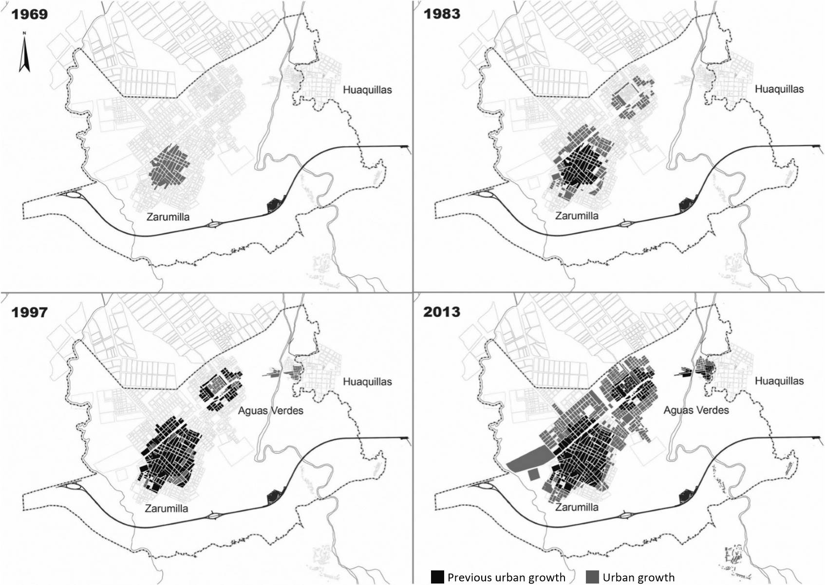
Source: Compiled by the authors with information from the municipality of Zarumilla (2013).
Map 1 Conurbation Process of Zarumilla and Aguas Verdes, 1969-2013
The above date allows an appreciation of two important points: the predominant agricultural use of the land and the importance of the military presence in the area. During the first Ecuadorian-Peruvian conflict in the 20th century, the military presence at the entire border became more and more important as a strategy and interest of the Peruvian state to populate and control the zone in political and military terms. This is part of the process of drawing boundary lines in the sense of Newman (2003); that is, the importance of this situation is that it sought to be both an act of the definition of sovereignty (drawing lines between two groups), but also propitiated the presence and establishment of people in that territory.
It is important to caution that even when there were tensions between Ecuador and Peru, the border zone was attractive due to the opportunities or commercial expectations that it generated in the population-mainly the migrants (Hocquenghem and Durt, 2002). In other words, the military presence and the low permeability of the borders did not necessarily mean that they did not operate as spaces of integration, as they continued to generate economic expectations that were reflected in commercial activities.
This makes it worthwhile to take a look at the last stage of the Peruvian-Ecuadorian conflict, the War of Cenepa (1995). This brief armed conflict ended with the Itamaraty Peace Declaration, in Brasilia, in February 1995. This was the first accord and brought about a set of bilateral agreements between Ecuador and Peru; these had direct effects on the border area, beginning with the signing of the peace accord in October 1998. In this framework, the Comprehensive Agreement on Border Integration, Development and Neighborly Relations, in which the intention of both countries to liberalize the f lows of goods, persons, and services is made explicit (Hocquenghem, 2009; Hocquenghem and Durt, 2002).
Afterward, the Binational Plan for the Development of the Peru-Ecuador Border Region was signed, which had its origin in the signing of the peace accord of 1998 and was originally designed to bring about development during the 2000-2008 period; in its final year the accord was extended for five more years, and in 2012, it was extended again, for 10 years, until 2021. The major objective of the plan, in its Peruvian and Ecuadorian chapters, is to improve the quality of life of the population in border areas, through interventions in axes such as health, education, transportation, water, and sanitation, among others (MRE, 2006). Nevertheless, its focus has mainly centered on projects of social and productive inffrastructure, as well as the promotion of private investment (MRE, 2006). Thus, it is possible to say that the investment in infrastructure has not been articulated with the development of social programs or improving the management of public services (Hocquenghem, 2009; Hocquenghem and Durt, 2002).
Together with the signing of the peace accord, pacts were signed such as the Comprehensive Agreement on Border Integration, Development and Neighborly Relations, and the Convention to Hasten and Deepen Free Trade between Ecuador and Peru (Hocquenghem and Durt, 2002). In the same years as those agreements, some changes took place with respect to the spatial structure and form of the border area (Map 1, 1997 chart). The image shows a moderate expansion of some settlements that surround the urban core of Zarumilla, and a greater consolidation of the urban framework of Aguas Verdes. The first important developments in the border strip with Ecuador, which now form the business areas of the district, connected with the business zone of the Huaquillas municipality. During this period new human settlements such as Los Algarrobos appeared, and others were consolidated, such as la Curva, Villa Primavera, and Complejo Habitacional Fronterizo, among others. The following quote describes the process of urbanization that took place between 1983 and 1997, which caused land that had been used for agriculture to be divided into lots and, in some cases, given titles.
It was a wooded zone ... then everyone, the people came and cleared it with their machetes and they located there. No one told them not to. At that time there was no control. Little by little they went positioning themselves. When we began to make the regulatory plan, which was in 1986, and it was around the end of the certification process, we had to make a development plan with Zarumilla. A land survey of this place was done, that was in 1994, those areas got titles; before landholding was by possession, it was not regularized (Interviewee A, interview, 2014).
That is, the urban expansion in recent decades has been characterized by a precarious delimitation of land uses, added to the necessity of the settlement of residents who had migrated, and of some others who had expectations to relocate as close as possible to the border line. These processes are the result of the interaction of actors who operate on different scales such as the residents, businesspeople, and the government in its various subnational levels (local, provincial, and regional) and national ones.8
With respect to the abovementioned, there are two central phenomena that characterize the pattern of the occupation of the border conurbation from the 1990s to 2013. The first has to do with nature and refers to the phenomenon of El Niño, which affected the Peruvian coast in 1998 and caused the flooding of a large part of the business zone of Aguas Verdes, classified as a vulnerable area. The relocated population settled in places such as Nuevo Aguas Verdes and Villa Primavera, physically connected with the fabric of the city of Zarumilla.
The second phenomenon is of an economic character and is related to the complementary asymmetries characteristic of the border: the dollarization of the Ecuadorian economy9 and the intensive commerce in products from one side of the border to the other. In accordance with the information gathered through interviews and focus groups, it is commonplace to associate this last occurrence with the deepening of migratory flows toward the conurbation.
After 2000, the vulnerable land of the Aguas Verdes business zone was resettled and various human settlements expanded, some of them almost at the edge of the shrimp farming areas close to the ocean. Urban expansion was characterized by the occupation of hazardous and vulnerable spaces, affecting neighboring ecosystems.
The agreements resulting in the peace accord between Peru and Ecuador responded to new objectives, in a context where boundary conflicts diminished worldwide, with its becoming more important to integrate and develop borders in socioeconomic terms. This generated economic expectations in certain sectors, and, in the case studied, influenced-together with topographical characteristics of the territory-in the type of urban expansion of the cities of Zarumilla and Aguas Verdes. What most clearly shows this is the location of business zones: next to the boundary on both sides.
This analysis of urban expansion helps identify how the processes of international scale-multilateral decisions-and national scale affect the settlement patterns of border zones. In the case of Zarumilla and Aguas Verdes, important changes can be seen beginning with events such as the Peruvian-Ecuadorian peace process, natural phenomena such as El Niño, and policies implemented on the other side of the border line, such as the dollarization of the Ecuadorian economy. All these helped intensify the dynamics of population growth and urban expansion.
On a more micro scale, the process of conurbation between Zarumilla and Aguas Verdes was studied. Similarly, information was obtained that suggests that these phenomena serve both as factors of attraction in the logic of complementary asymmetries, such as the pattern of urban expansion following a logic of slum development, but in constant negotiation with the authorities, where business-people-migrants are established as important actors, and patronage relationships as a strategy of access to land.
Population growth and attraction of the border conurbation
The abovementioned is seen in the demographic changes occurring in this area; the population of the districts of Aguas Verdes and Zarumilla has grown in recent decades. Population growth during the years between censuses shows that the most important growth rates are for the periods 1961-1972 and 1972-1981, at 4.37 and 5.57, respectively (INEI, 2010). These rates surpass those of the province of Zarumilla for the same periods (3.51 and 4.36, respectively) and of the department of Tumbes (2.91 and 3.45).
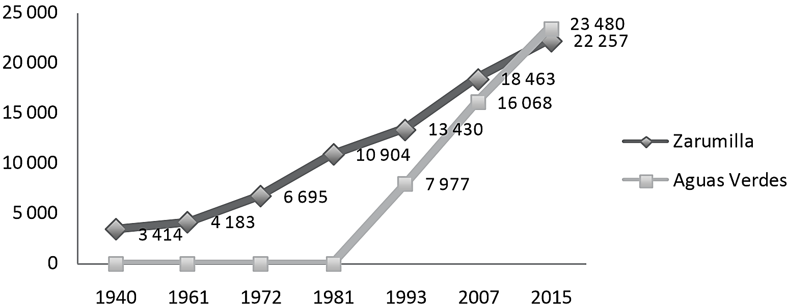
Note: For 2015, projections made by INEI (2010) are used.
Source: Drawn up based on INEI (1940-2007).
Graph 1 Population Growth of Zarumilla and Aguas Verdes, 1940-2015
Graph 2 shows that before 1984, most of those surveyed lived in the district of Zarumilla. The main reason for this is because Aguas Verdes was not formed as a district until 1985. For the following periods, the population of Aguas Verdes grows at a greater number than Zarumilla and with a greater difference in the last period (2004-2014). This shows that both political and economic factors can be linked to these migration processes toward the border area.
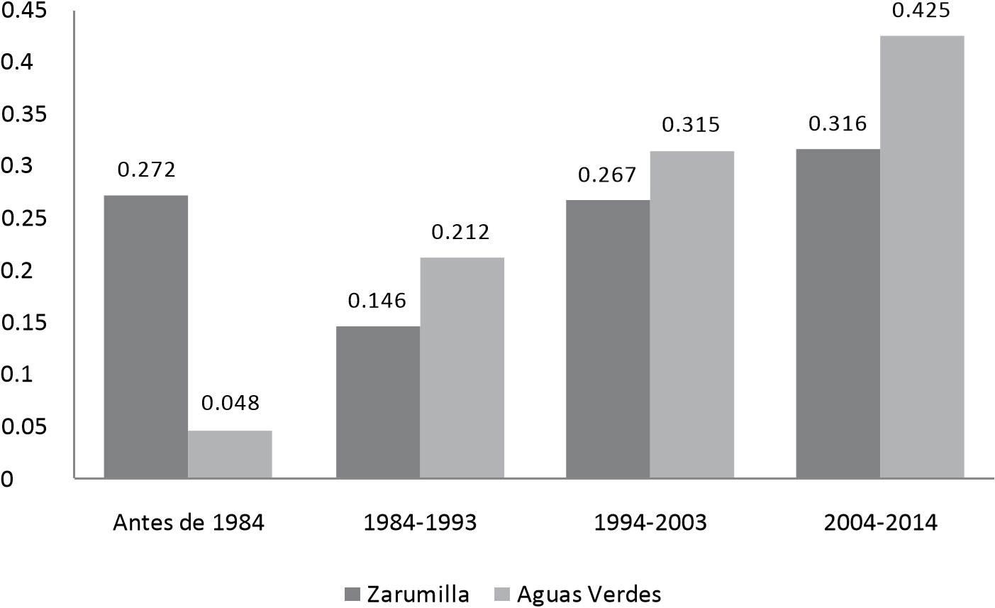
Source: Bensús and Dammert (2014)
Graph 2 Year of Migration According to District of Residence (by periods)
An important issue to explore is internal migration toward Zarumilla and Aguas Verdes. About 40 percent of the residents were born in the neighboring department of Piura, which shows how migration toward the border area mainly comes from the regions in the north of the country. An examination of the periods of migration shows that the number of people who have migrated from Piura is the greatest. Of the total number of migrants who moved before 1984, only 20 percent came from Piura; for the 2004-2014 period, this percentage grew to 50 percent. This presents a reverse pattern of the case of persons who migrated from the rest of the department of Tumbes: It sent 77.8 percent of the migrants born before 1984, but 24.4 percent for the period 2004-2014.
Table 1 Year of Migration per Time Period and Place of Origin (percentage) (before 1984-2014)
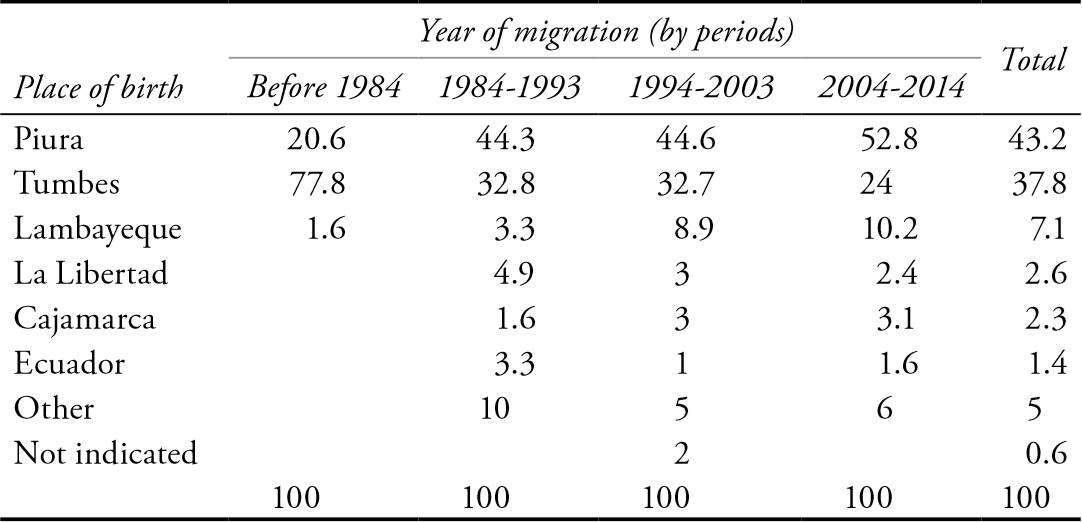
SOURCE: Bensus and Dammert (2014).
The main reason behind decisions to migrate has been work issues (employment or search for employment), followed by family reasons or to be with a partner. Zarumilla and Aguas Verdes are poles of attraction due to their border business activities, and for the family social ties formed through these activities.
Mobility toward the border: Huaquillas as part of the urban continuum
The population growth of the border districts of Zarumilla, and mainly Aguas Verdes, has its own mobility dynamics. Ninety-five percent of those surveyed say they have crossed the border into Ecuador at least once, which means that three of every four persons cross the border at least once a month, with most crossings having to do with the temporary movement of labor.
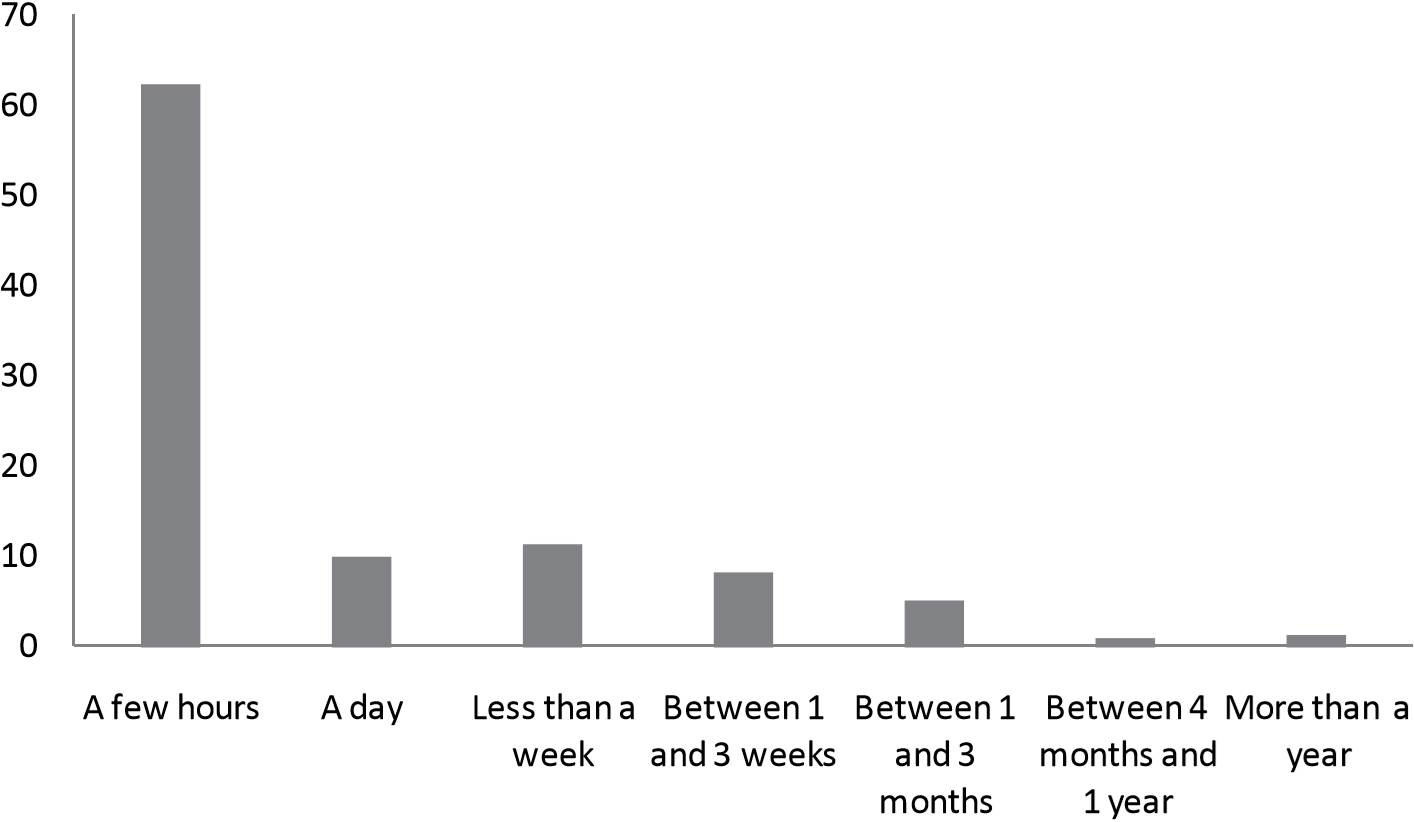
Source: Bensús and Dammert (2014).
Graph 4 How Long Did People Stay after Crossing the Border? (percent)
The activities they do on the Ecuadorian side of the border are limited, and are mostly done the same day. This is a situation that acquires greater importance when it is seen that for many of the residents interviewed, Huaquillas (Ecuador) is not viewed as being outside of Peruvian territory. That is, it is not symbolically recognized as part of Ecuador. The continuum, in terms of daily activities that residents of Peruvian districts realize with respect to Huaquillas, shows the "porous" character of the border, in which this district operates, as previously noted, continuously and not as a break of space belonging to another country.
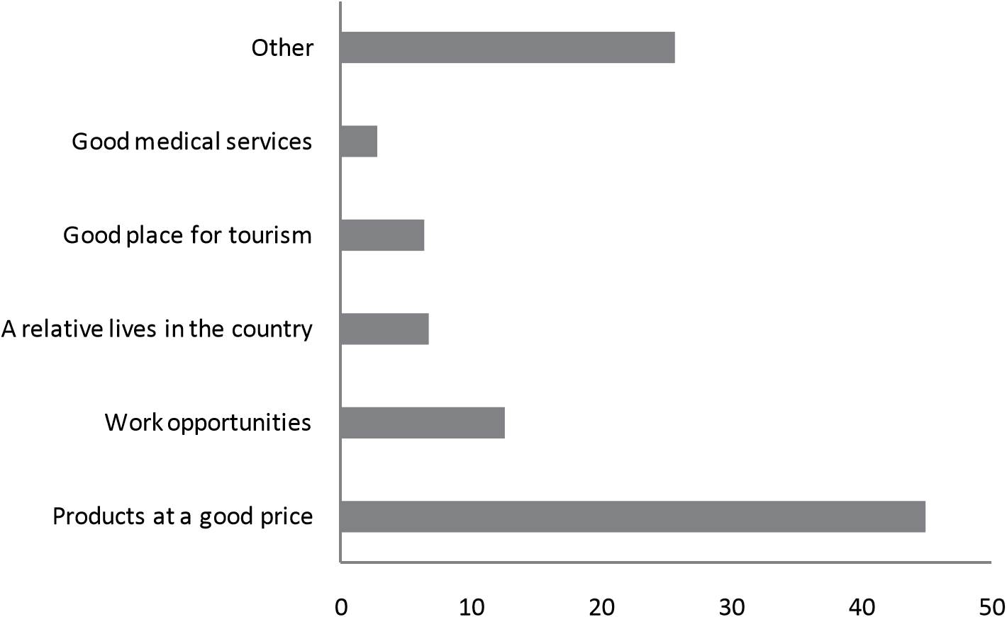
In terms of the destinations on the Ecuadorian side, the main one is Huaquillas (conurbated border zone with Aguas Verdes). The reasons people cross to that zone are mainly that they find lower prices for some products (45.1 percent) (milk, diapers, meat, bananas; also, other products sold in hardware stores). It is worth noting that 12.8 percent indicate that they go for work reasons and 6.8 percent for family reasons. An interviewee provides some information about these economic dynamics that involve a relationship of complementary asymmetry between both parts of the border.
My family makes its living from business, and we buy and manufacture here, and we take the products to Ecuador. In comparison with the Peruvian market, which is super exploited, in addition to being very saturated, we opted for Ecuador, because if we buy it for a sol, there we sell in dollars, we export (Interviewee B, interview, 2014).
With respect to making trips for recreational purposes, purchases, and public services, the following information was obtained from the residents of Zarumilla and Aguas Verdes: In the case of trips to make purchases, it was found that the majority are made to Aguas Verdes, both for residents of Zarumilla and Aguas Verdes,10 emphasizing and confirming the commercial attraction this district has. Similarly, the percentage of trips made to Huaquillas for shopping is far greater than for trips made there for recreational purposes.
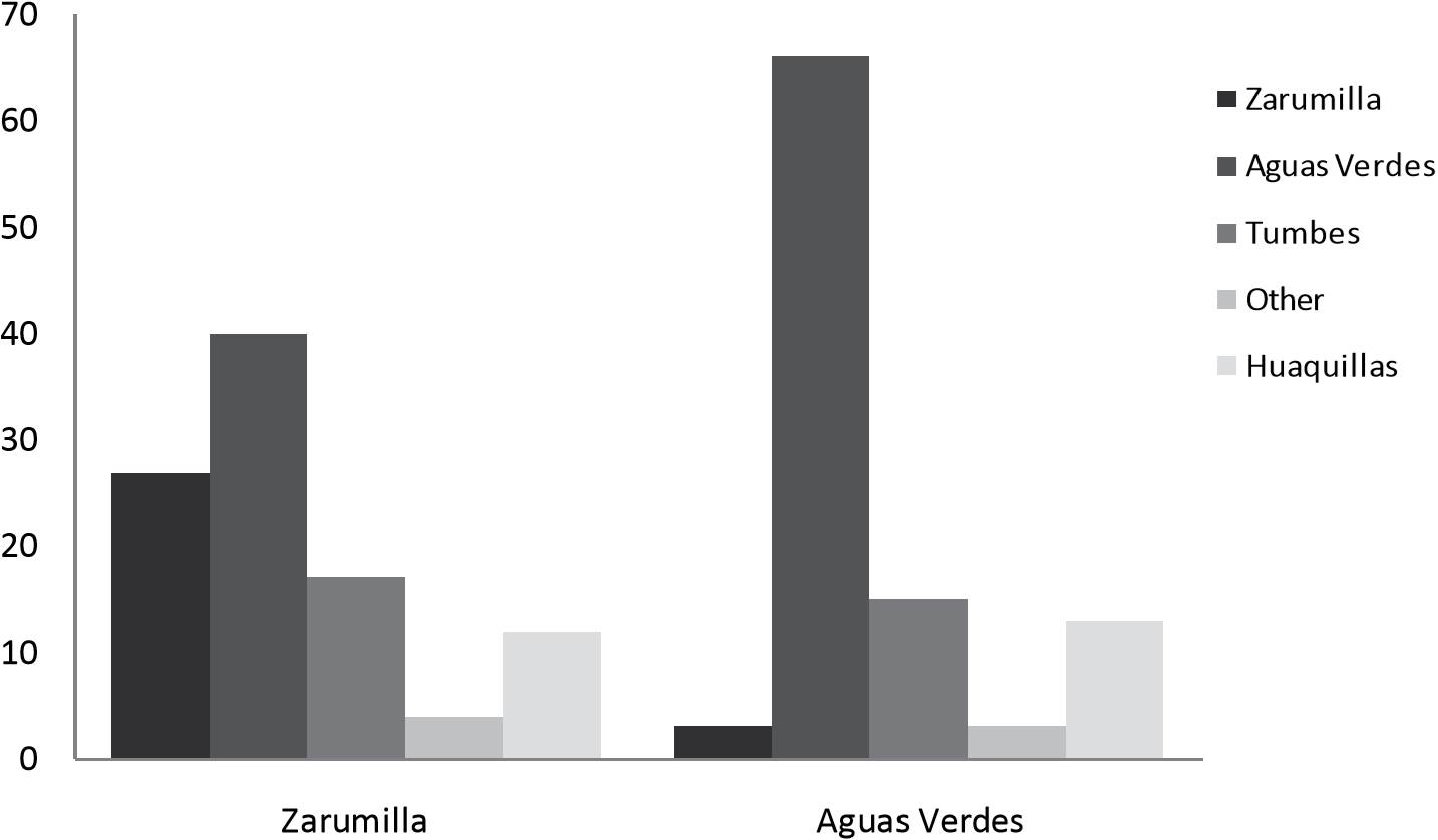
Note: Total trips from Zarumilla: 537. Total from Aguas Verdes: 384.
Source: Bensús and Dammert (2014).
Graph 6 Destination of Trips for Purchases According to Place of Residence (percent)
In terms of recreational activities, Zarumilla is seen as a destination for the inhabitants of both Zarumilla and Aguas Verdes. Nevertheless, for purchases, Aguas Verdes is the greater point of attraction, while Tumbes has become known for services or transactions. On the one hand, this shows how the Zarumilla-Aguas Verdes conurbation presents mobility patterns according to the activity its inhabitants undertake and shows the distribution of facilities and establishments on each side. On the other hand, this draws attention to Huaquillas' importance as a node in terms of recreation and, mainly, for purchases. Figures about the frequency of border crossings indicate that the percentage of trips to Huaquillas may have been greater; nevertheless, it is possible that this was because a large part of the border crossings are for work reasons.
Conclusion
Borders are territories that present different types of human settlement. One of them is that of conurbated border cities, or, simply, border conurbations. Below, some of the central ideas of this work will be enumerated. First, the influence of processes of different scales in the border dynamics, discussed by authors such as Perrier (2007, 2013) and van Schendel (2005), should be recognized. A historical review of urban expansion and the analysis of population growth find that important changes in the border zone were produced as a result of the creation of the district of Aguas Verdes (as a consequence of local demand and the state's interest in having a greater presence and settlement in the border area) and of the resolution of the boundary conflict with Ecuador (international scale). On the one hand, the establishment of a business zone in the border strip brought about a significant urban expansion. On the other hand, the population grew, particularly in the corresponding territory of Aguas Verdes district. These events were the result of negotiations, political decisions, and collective actions by economic and social actors, among other phenomena on various scales. The border zone or border conurbation is articulated with the processes and actors that cut across it and include the local scale and what directly affects it (Carrión, 2013; van Schendel, 2005).
Second, the bulk of the population of the conurbation has a migratory origin. The main departments this sector of the population comes from are Piura, Tumbes (from different districts than the conurbation), and Lambayeque. The main attraction is the employment possibilities associated with living in the conurbation. The second-most important attraction has to do with family decisions, which suggests the importance of social capital as a motive for migration, something future studies should examine in more detail. This only confirms the type of attraction the urban border area has for migrants.
Third, the analysis of the daily and seasonal mobility of the residents of Zarumilla and Aguas Verdes shows several interesting points. Crossing the national border is done frequently and does not involve very long stays. Also, the perception of Huaquillas as being part of a single urban system is shown in the difficulty those surveyed and interviewed had in identifying the municipality as Ecuadorian territory. That being said, it is important to address that the same survey shows that the city is not the principal destination for activities such as recreation and purchases; this could be related to the costs involved when the Ecuadorian currency is the dollar. In contrast, the city of Tumbes-the departmental capital-generates an important attraction of flows, which involves a regional scale of border influence.
Finally, the study allows an understanding of the link between the border space and socioeconomic and political relations on different scales. That is, global processes (expansion of markets) and international ones (peace process and, later, dollarization of the Ecuadorian economy) permitted the development of commercial activities based on complementary asymmetries between the two sides of the border. The increase in business activity was closely tied to the creation of the district of Aguas Verdes and its capacity to manage the border area for business purposes. All the above-mentioned processes involve a greater ability to attract the migrant population to the zone. This migratory process has had two effects. The first is the accelerated expansion of the urban fabric in recent decades. The second is linked the dynamization of business activity, and, also, illegal markets. The spatial dynamics are not only an effect, but what sustains and strengthens business activities in the border zone and vice versa.

