


Servicios Personalizados
Revista
Articulo
 Inglés (pdf)
 Artículo en XML
 Referencias del artículo
 Enviar artículo por email
Indicadores
-
 Citado por SciELO
 -
 Accesos
Links relacionados
-
 Similares en
SciELO
Similares en
SciELO
Compartir

 Permalink
Frontera norte
versión On-line ISSN 2594-0260versión impresa ISSN 0187-7372
Frontera norte vol.27 no.53 México ene./jun. 2015
Artículos
The Argentina-Uruguay Border Space: A Geographical Description
El espacio fronterizo argentino-uruguayo: Una descripción geográfica
Alejandro Benedetti
Consejo Nacional de Investigaciones Científicas y Técnicas / Universidad de Buenos Aires alejandrobenedetti@conicet.gov.ar
Date of receipt: April 23, 2014.
Date of acceptance: June 24, 2014.
ABSTRACT
This paper is part of a more extensive research project being carried out at the Institute of Geography of the University of Buenos Aires, whose purposes are 1) to describe and analyze the South American border spaces and 2) to understand what role they play in national territory-building. A geographical description of the Argentina-Uruguay border space will be presented, using a model that considers six components: territorial differentiation, frontierization, subnational territory, supranational territory, border places, and mobility. The conclusions will show the main spatial continuities and discontinuities identified there.
Keywords: 1. border space, 2. delimitation; 3. frontierization, 4. Argentina, 5. Uruguay.
RESUMEN
Este trabajo forma parte de una investigación más amplia que se está desarrollando en el Instituto de Geografía de la Universidad de Buenos Aires, la cual tiene como propósitos: 1) describir y analizar los espacios fronterizos interestatales sudamericanos, y 2) comprender su función en la construcción de los territorios nacionales. Aquí se presentará una descripción geográfica del espacio fronterizo argentino-uruguayo, siguiendo un modelo de análisis que considera seis componentes: diferenciación territorial, fronterización, territorios subnacionales, territorios supranacionales, lugares de frontera y movilidades. En las conclusiones se expondrán las principales continuidades y discontinuidades espaciales allí identificadas.
Palabras clave: 1. espacio fronterizo, 2. delimitación, 3. fronterización, 4. Argentina, 5. Uruguay.
INTRODUCTION
This article will offer a geographic description of the Argentina-Uruguay border space. The idea of border space is preferred to that of border, considering that, in most South American countries, this last term defines the strip, adjacent to the boundary, that extends toward the national interior. Border space includes the boundary established through mechanisms of diplomacy or war between two entities that, simultaneously, exercise their territoriality. In this case the countries involved are Argentina and Uruguay, states established as part of the system of nations that has been evolving since the 19th century. In addition to the international boundary, another constituent element of the border space is the zone or district that each state established next to the boundary as part of its policies of linking with its neighbor, be they for defense or integration. Clearly, many other elements take part in shaping the border space and exceed the confines of the national states concerned. The generic expression border spaces (and not border territory) is used because spatialities of a diverse nature get established there: Some are shared in common or are necessary for the permanence of the state territories, whereas others, on the contrary, challenge the control capacity of one or both states in this space. In short, border space is a generic, broad category that looks to focus on nation-state territorial action (that is, the exercise of power through use of space), but without a fetishistic attachment, considering the state to be the only agent with the capacity for territory-building. Businesses, societal organizations, churches, and other social agents challenge each other over the control of people and resources in those spaces where the states established the international dividing line and the two national borders.
The theoretical-methodological perspective guiding these considerations comes from two approaches of contemporary geography, one of which can be called relational and the other political-cultural. It is not the intention of this text to develop a theoretical-methodological approach for the study of the borders, a subject that has been examined in other recent publications (Benedetti, 2014; Benedetti and Salizzi, 2011, 2014).
The work published here arose from a medium-term project to study southern South American border spaces —of Argentina and its five neighboring countries, sometimes called the Southern Cone— being carried out at the University of Buenos Aires. The objective is to reconstruct and to describe South American border spaces, considering the system of international boundaries and national borders, jointly with the multiplicity of associated territorialities that have been established in the southern end of Latin America from the 19th century. In this article a geographical description will be made of the Argentina-Uruguay border space (henceforth to be called EFAU, the Spanish initials for espacio fronterizo argentino-uruguayo): This border space is built around the fluvial-marine system of the Uruguay River and the Río de la Plata. It emerged, basically, through the exercise of territoriality there by Argentina and Uruguay. It is a matter of two modern, national states that, as such, base their permanence on exclusive, and excluding, control of a portion of the Earth's surface: The Argentine part is to the west of that axis and the Uruguayan part to the east. As previously mentioned, the generic idea of border space will be put to use, showing the international limit that divides those lands, giving origin to a bipartite organization, a dyad (the Argentinean-Uruguayan space), and of the two national borders (henceforth referred to as border) that those countries established in their respective territories, juxtaposed, from the boundary toward the interior, through various material and symbolic mechanisms. The northern end of the EFAU borders the territory of Brazil. There is a trilateral entity there, a triad, and a tripartite border space, that will be taken into account in a secondary manner.
There are two objectives, then. The first, a subsidiary of the second, is to reconstruct, in very broad strokes, the process of forming the EFAU. The second objective, the main one, is to come up with a description of the geographic organization of the EFAU. Any space, border or not, can be thought of as an inseparable whole, shared yet contradictory in objects and actions, which should not be considered separately, and that form the framework in which social processes occur (Santos, 1996). When focus is placed on a border space, as proposed here, one must pay attention to at least six sets of objects and actions: 1) territorial differentiation; 2) frontierization; 3) inner territory; 4) outer territory; 5) border places; and 6) mobility. A strategy of cartographic reading examining different layers of information was taken: Each one of these sets of objects or actions, which also could be called components of space, is part of a process that has its own temporality and spatiality, but that modifies or is modified by other concomitant processes. This distinction in layers or components, we should clarify, is analytical. In order to undertake the study of these various components of the EFAU, a system was developed to organize a body of information from official sources and nongovernmental organizations, field observations, and bibliographical material. The scope of this paper limits specifying all the theoretical-methodological decisions used in the elaboration of this analytical model. For more information, see Benedetti (2014).
This article is divided into five sections. Components 1, 2, 5, and 6 will be examined separately. Components 3 and 4 will be reviewed in a single section. In the conclusion, a synthesis of the Argentina-Uruguay border space social processes will be made.
TERRITORIAL DIFFERENTIATION
The EFAU emerges where the territories of two national states, Argentina and Uruguay, are juxtaposed; both emerged and consolidated simultaneously. Multiple relationships involving neighbors, mostly friendly, were established over time. Here two sub-components will be identified and described: land distribution and delimitation.
Land Dstribution
The process of differentiation and mutual territorial configuration of Argentina and Uruguay covers two centuries. The creation of the Viceroyalty of Río de la Plata had as its objective, among others, assuring the inclusion of Montevideo and its environs in Hispanic territory. The breakdown of the colonial order was followed by a long process of reorganization, giving rise to various geohistorical entities that ultimately developed into the configuration of these two independent republics. At the beginning of the 19th century, concurrently with the beginning of the independence process in the Viceroyalty of Río de la Plata, the kingdom of Portugal—which had established its main colony in Brazil—was in the process of extending its dominion toward more southerly lands, advancing to the Río de la Plata. These lands were known as the Banda Oriental (Eastern Strip) because of their location on the eastern bank of the Uruguay River-Río de la Plata fluvial system, opposite the side Buenos Aires was on. Control over this zone was consolidated in 1821, and it was incorporated into the Portuguese kingdom under the name of Cisplatina Province. In 1825 a group of soldiers fighting for independence —known historically as the 33 Orientales (Easterners)— proclaimed the independence of the Banda Oriental with the support of Buenos Aires. This led the Empire of Brazil (formed in 1822) to declare war on Buenos Aires Province. That fight extended until 1828, when Great Britain mediated in order to create an independent state that also served as a shock absorber between Brazil and the United Provinces of Río de la Plata, the future Argentine Republic (Madrid, 2004). In this way Uruguay was transformed into a "buffer state" between two lands that over time would become the two biggest and most powerful countries in South America: Argentina and Brazil (Thual, 1996). The Preliminary Peace Convention (Treaty of Montevideo) signed by the belligerents (Gobierno de las Provincias Unidas del Río de la Plata and Imperio del Brasil, 1828), which put an end to the Cisplatine War (or Argentine-Brazilian War), recognized the existence of the Estado Oriental (Eastern State). It established the Uruguay River as a geophysical unit from which Argentine and Uruguayan territory would be differentiated, although it took until 1961 for the republics of Argentina and Uruguay to sign their first border treaty. From 1828, no substantial land redistribution took place in the territories that were consolidated on each side of the fluvial-marine system of the Uruguay River and Río de la Plata. The relevance of these rivers in the history of these countries was shaped, symbolically, in their respective names: Uruguay took its name from the Uruguay River; the name Argentina comes from Río de la Plata [Silver River], (from argentinus, argénteo [silvery], Argentine, that is to say, of silver).
Delimitation
The boundary was not an urgent subject in the bilateral agenda of first half of the 19th century. During the second half of that century, the main issue was, in both countries, the formation and consolidation of both states and the organization of their territory. The rivers were mentioned in constitutional documents. The Constitution of the Republic, names the Eastern State of Uruguay as a formal political entity. In its introduction, it mentions the river of the same name as the western boundary: "We, the Representatives named by the peoples in the Eastern part of the Uruguay River… form a free and independent State…" (República Oriental del Uruguay, 1830). Mention of the Río de la Plata is not made until the Constitution of the Argentine Republic of 1994 (República Argentina, 1994), and even then it is in reference to the early name of the country: United Provinces of Río de la Plata. Once the initial process of state formation had taken place, there were no military conflicts between both countries; this henceforth engendered a diplomatic understanding between the two nations (Cisneros and Escudé, 2000).
At the beginning of the 20th century, the Río de la Plata and the Uruguay River functioned under the principle of common use of their waters. During the first half of the 20th century, the modus vivendi came from traditional use, based on buoys that larger boats navigated around. In 1938 an act was signed that maintained the status quo of the islands in the Uruguay River and that proposed studying a definitive solution to the boundary problem, for which a joint technical commission was created. That commission returned to life in 1946 with the signing of an agreement on the utilization of the rapids of the Uruguay River at Salto Grande, maintaining the principle of common use of its waters and fostering the construction of a binational hydroelectric plant. It was only in 1957 that delegations were formed and began to carry out some studies. In 1961, finally, two documents were signed that allowed a breakthrough in setting the boundary: 1) Joint Declaration on the Outer Boundary of the Río de la Plata (República Argentina and República Oriental del Uruguay, 1961a): It instituted the Plata as a river and not an estuary, leaving it outside treaties on free navigation of the seas, to Great Britain's objections; 2) Uruguay River Boundary Treaty (República Argentina and República Oriental del Uruguay, 1961b): It established a boundary that in its first section (from its beginning to the area of the Salto Grande dam) followed the center of the river channel; from there until Punta Gorda (formally considered to be the start of the Río de la Plata) the boundary follows the main axis of navigation. In 1973, finally, the Treaty of the Río de la Plata and its Marine Front (República Argentina and República Oriental del Uruguay, 1973) was signed, creating the Administrative Commission of the Río de la Plata and the Joint Technical Commission of the Marine Front. This measure kick-started the signing, in 1975, of the respective statute for the Uruguay River, where the Administrative Commission of the Uruguay River was created.
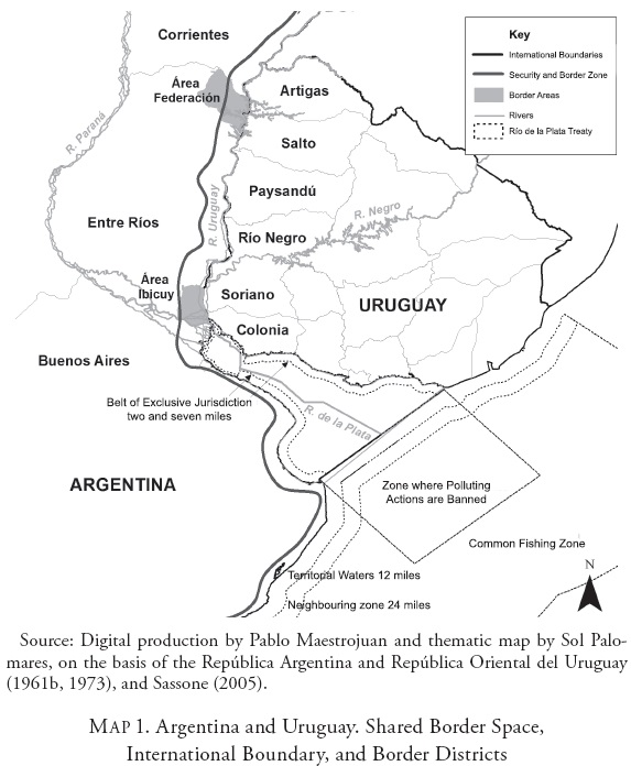
The Argentine-Uruguayan boundary extends for 495 kilometers (308 miles) in the Uruguay River and some 300 kilometers (186 miles) in the Río de la Plata (Map 1). It was one of the first agreements in South America to set a de facto boundary, but one of the last to set a de jure one.
THE ARGENTINE-URUGUAYAN PROCESS OF FRONTIERIZATION
The neologism frontierization (Grimson, 2003) seeks to emphasize the contingent and process-based character of the borders established by both countries. That notion holds that the central powers were establishing, on their border or its vicinity, a set of physical and symbolic elements in order to control access to—and establish—national territory. Three subcomponents will be identified: districts, crossings, and posts.
Border Districts
Here a border district is defined as a division of national territory adjacent to the international boundary. They are established by the states to execute actions such as security, defense, development, urbanization, road planning, or strategic resources protection. In the Argentine case, it went about establishing various border districts (Sassone, 2005): 1) Security Zones (1944), which defined actions for standing guard for security and defense reasons at the boundary and at particular sites in the interior of the country (airports); 2) Border Security Zones (1946), which were strips of different widths depending on the neighboring country, contiguous to the boundary, subject to adjustments: 50 kilometers (31 miles) for the area contiguous with Uruguay; 3) Border Development Zones (1970), defined as part of a more active border policy, advocated in speeches and geopolitical actions; one was not established in the EFAU; 4) Border Areas (1970), created within the aforementioned zones, with the idea of intervening in the case of special situations and conditions that require high-priority promotion for their development; all together there are 11 zones, none of them next to the boundary with Uruguay; 5) Security and Border Zones (1994), through the unification of aforementioned zones; in the zone adjacent to Uruguay, two border areas were established: Ibicuy and Federación (Map 2). Uruguay did not create any border district like Argentina did. However, legislation does exist that has to do with border traffic, and that has a common legal framework for both countries, resolved within the scope of Mercosur through the Decision no. 18/99 of the Common Market Council (CMC, 1999). This norm establishes a radius of 50 kilometers from the border crossings toward the interior of both countries. Within that area, the resident population can acquire a card that allows those who cross the border frequently to do so with greater ease. This measure, however, is not totally effective (Silva, 2014).
Border Crossings
All along the boundary, entry points have been instituted where legal crossings are allowed. Both borders of this space are separated by the Uruguay River-Río de la Plata axis, a hydromorphological discontinuity that operates as a barrier to land travel, but does not offer too much difficulty for a water crossing. In addition, these rivers are a route —some of it a transatlantic one— for the circulation of goods. There are 11 crossings, three of them multimodal (fluvial and highway): 1) Gualeguaychú-Fray Bentos, 2) Colón-Paysandú, and 3) Concordia-Salto (also a rail crossing). The others are only fluvial (Table 1). The city of Buenos Aires is connected, by means of fluvial bridges, with Carmelo, Colonia, and Montevideo.
Control Posts
The control of the crossings presupposes the presence of public administration dependencies in fixed posts. The states have constructed buildings at the crossings or in their immediate environs to establish the agencies invested with the authority to control the movement of people and merchandise that cross the boundary. In addition, there are mobile control posts located at various distances from the boundary, that move around the area, generally at crossroads connected to unauthorized crossings. There are fixed posts of control at all the legal crossings. At the fluvial crossings, there are two sets of controls. Security, and customs and immigration control (through a delegation of powers), is the responsibility of the Argentine Coast Guard (n. d.) and Uruguay's National Navy, respectively. At the three road crossings, three Integrated Control Areas were established as part of Mercosur initiatives: 1) Gualeguaychú-Fray Bentos, 2) Colón Paysandú —both headquartered on the Uruguayan side—and 3) Concordia-Salto—with headquarters on the Argentine side— (Table 1).
SUBNATIONAL AND SUPRANATIONAL TERRITORIES
The national borders coexist with other kinds of territories. Here subnational and supranational zones are overlaid on the border space.
EFAU Border Institutions
There are many state institutions with direct powers along the border (Table 2). Some create their own zones, such as the Argentine National Gendarmerie, which in the Argentine part of the EFAU has established Groups III-Corrientes and V-Entre Ríos. Entre Ríos is subdivided into the squadrons 56-Gualeguaychú, 6-Concepción del Uruguay, and 4-Concordia; the squadron Paso de los Libres, within Group III-Corrientes, is in the northern part and extends to the Argentine-Brazilian border space.
Administrative Territories with Border Implications
It would be impossible to enumerate all the public agencies with jurisdiction in the EFAU. An interesting case is that of institutions involved the conservation of natural areas that, without having a strictly border function, participate in shaping it. On the Argentine side, the most important is El Palmar de Colón National Park; on the Uruguayan side, the natural protected area Esteros de Farrapos e Islas del Río Uruguay National Park (Farrapos Estuaries and Islands of the Uruguay River). These areas have played an important role in the national imagination when it comes to the national landscape.
Subnational Bodies of the EFAU
In the EFAU, a subnational state territorial overlay has been formed, with different degrees of autonomy on each side of the boundary. Argentina, a federal country, has 23 (autonomous) provinces, plus the Autonomous City of Buenos Aires (henceforth referred to as CABA, using its Spanish initials) (República Argentina, 1994); from south to north in the EFAU are: Buenos Aires, CABA, Entre Ríos, and Corrientes. The provinces are divided into municipalities: Entre Ríos has 16 municipalities adjacent to the international boundary with Uruguay; Corrientes has three (Table 3).
Uruguay, whose territorial organization has followed the unitary state tradition, is divided into 19 departments (República Oriental del Uruguay, 1967), each of which is an intendencia, a political-administrative unit governed by a departmental council —with deliberative powers— and a governor (intendente) —with political and administrative powers. The departments next to the international boundary with Argentina are: Colonia, Soriano, Río Negro, Paysandú, Salto, and Artigas, which are divided into local councils, 11 of which are in the EFAU (Table 3). If the Río de la Plata section is included, the departments —from east to west— Maldonado, Canelones, Montevideo, and San José, would be added.
Territories that Cross the Boundary
There are an endless number of supranational territories that cross the Argentina-Uruguay boundary. Among them are: 1) The supranational territories with an area equivalent to the sum of the countries, such as Mercosur or Unasur, which affect borders, for example, by modifying migratory norms; 2) Those that have an area that does not add up to the sum of the countries, such as those created by the states to manage shared basins (Table 4); and, 3) Those created by the national states, where state groupings and private actors, including border commissions, created to resolve operational problems at border crossings and in neighboring cities—in the EFAU such groupings include Bentos-Gualeguaychú, Paysandú-Colón, Salto-Concordia, and Monte Caseros-Bella Unión.
MOBILITY AND THE BORDER
Mobility is a social relationship linked to the change of location of people or their goods between different spaces (Levy, 2000); it is a type of spatial relationship. The border and mobility are necessary and inevitable. International borders can be thought of as mechanisms created by the states, located at agreed-upon international boundaries, in their initial attempt to immobilize everything that looks to move toward or from the interior of the territory. This is where the interior/exterior tension arises, mediated by the border. The exercise of power always implies the manipulation of the opposition between continuity and discontinuity (Benedetti and Salizzi, 2011). Here attention will be paid to two subcomponents: infrastructure and transportation services. They are divided into three categories: interior, bilateral, and multinational.
Interior Mobility
Both sides of the EFAU have good connectivity with their respective interiors, primarily through highways. Railway and fluvial transport are minuscule by comparison. In Argentina, national routes (NR) 9, 12, and 14 constitute a continuous hub of circulation parallel to the Uruguay River that connect all the cities of the EFAU with Buenos Aires, toward the south, and with border cities with Brazil (Paso de los Libres) and Paraguay (Posadas) toward the north. National Routes 130, 18, and 127 connect those same cities with Paraná, capital of the province of Entre Ríos. In Uruguay, National Routes 1, 2, and 3 connect EFAU cities with Montevideo through a radial network. All the riverside localities rely on fluvial ports, mostly used for recreational activities. There also are numerous airports for recreational and productive services. Only those of Concordia and Salto have commercial air service with their respective national capitals or other small cities. Concordia has services with Buenos Aires through the company LAER (n. d.), like Salto does with Buquebus (n. d.) and LAER. In any case, these services only play a small role in medium- to long-distance passenger mobility: the primary mode of transportation for passengers is by bus, with service provided by numerous companies (Map 3). All this infrastructure and transportation services show the dynamism of this border area.
Binational Mobility
The cities of Buenos Aires and Montevideo are connected, via land, through NR 14 and NR 2. To make these links feasible, the building of three bridges on the Uruguay River was essential (Map 3). The Paysandú-Colón bridge was inaugurated in 1975, baptized as General Artigas; inaugurated in 1976 was the General San Martín Bridge between Puerto Unzué (adjacent to Gualeguaychú) and Fray Bentos (Horstmann, 1977; Castro, 1998), under the jurisdiction of the CARU. The third bridge is the upper part of the Salto Grande dam. It is a binational multi-use public work on the Uruguay River, initiated in 1974, that also makes possible the two countries' only rail connection. The first turbine was inaugurated in 1979, the last in 1983, and the bridge in 1982. Of the three bridges, the most important by volume of cargo and the number of people who cross is the General San Martín (the closest to the respective capitals).
Some fluvial ports operate as border crossings, utilized by the local population, and only some have regular transport service, with Carmelo-Tigre and Buenos Aires-Colonia-Montevideo being the most important connections (Map 3). In addition to having passenger service, some fluvial ports are equipped for international trade. The most important ones are on the Uruguayan side. The Argentine fluvial ports with the greatest export potential are on the Paraná River (such as Ibicuy). Of all the EFAU ports, Nueva Palmira is the one that moves the most cargo, because ships with deeper drafts can enter it, although with restrictions because of a lack of river dredging. On the Argentine side, Concepción del Uruguay stands out: it is the second port of Entre Ríos, after Ibicuy (Table 5).
Multinational Mobility
Much of the aforementioned national and binational road infrastructure was improved and redesigned to improve the continent's connectivity. This highlights the policy promoted by IIRSA (n. d.) to design multimodal transportation operating systems to connect port, metropolitan, and interior regions. IIRSA stands for Integration of Regional Infrastructure in South America. The EFAU finds itself involved in two of these systems: 1) The Mercosur-Chile integration hub, mainly organized around the highways that link São Paulo-Buenos Aires-Santiago and that established priority for National Route 14—which became a four-lane highway—in the EFAU; 2) The Paraná-Paraguay Waterway, which goes to the port of Nueva Palmira, which functions as an intermediary port for some cargoes, particularly for Paraguayan and Bolivian exports (Map 3).
BORDER PLACES
Many of today's EFAU agglomerations arose in colonial times. Some were founded through the advance of Jesuit missions along the Uruguay River, such as Villa de Soriano. Colonia del Sacramento, on the other hand, was part of the Portuguese advance along the Río de la Plata, opposite Buenos Aires, between 1680 and 1777 (Pereira, 2003). Other localities of colonial origin are Gualeguaychú and Concepción del Uruguay (on the Argentine side), and Mercedes and Paysandú (on the Uruguayan side). Several of these localities had and still maintain an important function in the shaping of Uruguay, such as Colonia, Fray Bentos, and Paysandú. The cities on the Argentine side were no less important, tied to the consolidation of the province of Entre Ríos, particularly CdU, which was its capital (Table 6).
The central importance exercised by EFAU agglomerations are only partly explained by their border location. Other factors are: the Uruguay River's capacity to be an overseas connection; its transformation into a zone of tourist attractions; and the formation of an agro-industrial zone with its own dynamism. This shows that the national states' activation of their respective borders did not play a role that excluded regional development and, therefore, the process of urbanization.
There are diverse border urbanization processes. Colón-Paysandú and Salto-Concordia are somewhat concentrated binational urban systems, with simultaneous urbanization processes and a strong interaction at various levels, in spite of the physical barrier of the Uruguay River. In the same situation, at the three-way border with Brazil, are Monte Caseros, Bella Unión, and Barra do Quaraí (Brazilian locality); Monte Caseros is connected by boat and the last two are united by a bridge. Gualeguaychú-Fray Bentos-Mercedes are part of a somewhat dispersed urban binational system, made up of distant localities, on both sides of the boundary, but with regular interaction. Cities without a border neighbor, that is, which do not maintain daily interaction with another neighbor across the boundary, are Nueva Palmira and Carmelo, located across from the great Delta of Paraná, a space without urbanization (Map 4).

In the EFAU, in addition, are the two capital cities, Buenos Aires and Montevideo, the nuclei of the extended metropolitan regions, which also could be considered as not having border neighbors. Although these cities are connected by all means of transport, their daily life is not generally marked by daily interaction with border neighbors, which is why a sense of being a border place was not developed in these cities. Colonia, finally, is a different case from the rest: It does not have a close neighboring city, but was transformed into one of the main entryways for Argentinians headed toward Montevideo and its coastal zone, and vice versa, which is why it has a nodal function in the system of binational circulation.
CONCLUSIONS
The conclusions presented here seek to highlight the spatial continuities and discontinuities identified in the EFAU.
The EFAU emerged as a necessary corollary of the construction of two juxtaposed state territorialities. The respective national states formed and maintained their own border spaces along the Uruguay River and Río de la Plata to mark their differences with their neighbor, and also to control all attempts to cross in either direction, even during times of integration. At the same time, this dynamic coexists and negotiates with other local, regional (subnational and supranational), and global dynamics. Unlike most of the South American international boundaries, the one that Argentina and Uruguay share was formally established rather late, only in the 1960s, although it had been functioning as one from the 1830s, at the least.
Argentina and Uruguay, like other South America countries, managed to establish their mutual borders next to the international boundary, overcoming all obstacles, including the lack of orographical ones. Also, like in the rest of the region, the larger effort to plan the shared space was concentrated in second half of the 20th century: the signing of border agreements, organization of the shared management of the Uruguay River and the Río de la Plata, construction of two bridges, and one hydroelectric-highway-railway project. The process of Argentinean-Uruguayan delimitation and frontierization was characterized by friendliness. During almost two centuries of shared history there were only two major conflicts: one, at the beginning of the 20th century, caused by the boundary being undefined; the other, more recent, was caused by the discontent of local actors, of the locality of Gualeguaychú, who shut the international bridge for a prolonged period as a result of the construction of two paper mills. This issue was broadly examined in the academic sphere between 2006 and 2009, when the conflict was the subject of great media attention.
A strong discontinuity in the EFAU between its north and south is hydrographic: the northern sector is built around the Uruguay River, which permits proximity between the national borders and for its cities to have neighbors. Toward the south/southeast, the Río de la Plata opens up, which puts more distance between the border cities. In formal terms, Punta Gorda is seen as the place that divides to both rivers. Using this convention, the Platense sector and the Uruguayan sector can be differentiated. Studies about this border area usually concentrate on the latter.
In the Platense sector are the capitals of both countries, nuclei of metropolitan regions that the EFAU gravitates around. In this sector, river, air, and land movements are intense, while at the same not developing a sense of clearly being border spaces. Buenos Aires and Montevideo do not have a direct road link. The distance between both cities by national routes, via the San Martín Bridge, is 562 kilometers (349 miles). In the Uruguayan sector, there is a much greater sense of a border. This sector has three road connections. In addition, it is crossed and accessed by various national routes, on each side, which guarantee great accessibility and an important connectivity of the border space with the interior of both neighboring countries (and the rest of the Platina Basin), something that is not so common in South America. Throughout that sector are found, from south to north, four sets of cities with certain regional autonomy: Gualeguaychú-Fray Bentos-Mercedes/Concepción del Uruguay-Colón-Paysandú/Concordia-Federación-Salto/Monte Caseros-Bella Unión-Barra do Quaraí (Brazil). This border sector exerts its influence on the national capitals thanks to its localities' closeness, in comparison with other border areas, and also because of its concentration of attractive activities. Latin American border spaces are often thought of as poor or economically marginalized areas. This is not the case of the EFAU: Its agro-industrial, tourism, and port development give the Uruguayan sector its own dynamism. In addition, it has a strategically important area: the Santiago-Buenos Aires-San Pablo corridor.
In order to draw up the international boundary, the neighboring countries chose a hydrographic feature, the Uruguay River, accentuating its function as a physical barrier to east-west circulation, beginning in the colonial period. That function has been maintained, even today. Nevertheless, that did not prevent its adjustment to the necessities of both countries: water transportation, a source for energy generation, a tourist-valued landscape, and a resource for the development of artisan and sport fishing. Taking the international boundary as its axis, the EFAU tended to take a rather symmetrical form. The most important cities have an equivalent on the other side of the river and these are connected to each other by means of bridges or binational river waters, particularly in the Uruguayan River sector. The pairings of neighboring cities do not offer contrasting urban landscapes to each other: all rely on similar services and infrastructure. Other symmetries, in the east-west sense, are due to their productive activities. Like facing mirrors, on both sides of the boundary, from south to north, apiculture, forest, cattle, soy, citrus, and rice zones follow one another. The forms that tourism has taken also have a great similarity on both sides: One example is thermal-waters tourism, which mainly takes place in the Concordia-Salto area. Aside from certain characteristics that can be associated with nationality, there are no noticeable sociocultural discontinuities: Language and accent, clothes and gastronomy, physical appearance, and the migratory origins of the people are similar.
In comparative terms with other South American cases, this is probably the most symmetrical border in sociocultural and productive terms. The asymmetries are rather conjunctural, deriving from the swings of the exchange markets or a boom in some activity that stimulates labor migration toward one side or the other. Another asymmetry that is beginning to occur has to do with the importance National Route 14 is taking on the Argentine side; it is becoming the main articulating hub of Mercosur.
REFERENCES
Alvarado, Raquel, 2009, "La expansión forestal en el Cono Sur. Políticas públicas, intereses transnacionales y transformaciones territoriales," Nueva Sociedad, no. 223, September-October, pp. 76-93. [ Links ]
Administración Nacional de Aviación Civil (ANAC), "Infraestructura y aeródromos," Argentine Republic, Ministerio del Interior y Transporte, available at <http://www.anac.gov.ar/anac/web/index.php/2/70/anac/infraestructura-y-aerodromos>, last accessed on June 10, 2014. [ Links ]
Benedetti, Alejandro, and Esteban Salizzi, 2011, "Llegar, pasar, regresar a la frontera. Aproximación al sistema de movilidad argentino-boliviano," Revista Transporte y Territorio, no. 4, pp. 148-179, available at <www.rtt.filo.uba.ar/RTT00409148.pdf>, last accessed on November 26, 2014. [ Links ]
Benedetti, Alejandro, and Esteban Salizzi, 2014, "Fronteras en la construcción del territorio argentino," Cuadernos de Geografía: Revista Colombiana de Geografía, vol. 23, núm. 2, pp. 121-138. [ Links ]
Benedetti, Alejandro, 2014, "Espacios fronterizos del sur sudamericano. Propuesta de un modelo conceptual para su estudio," Estudios Fronterizos: Revista de Ciencias Sociales y Humanidades, new era, vol. 15, no. 29, January-June, 2014. [ Links ]
Buquebus, n. d., BQB. "Líneas Aéreas," available at <http://www.flybqb.com.uy/BQBFly/web/Home>, last accessed on December 6, 2013. [ Links ]
Carasales, Julio César, 1998, "Comisión Administradora del Río Uruguay: Un ejemplo de integración práctica," Publicaciones de la Comisión Administradora del Río Uruguay, Paysandú, Comisión Administradora del Río Uruguay (Serie de Divulgación, no. 7). [ Links ]
Castro, José, 1998, "Puentes sobre el río Uruguay," Paysandú, Uruguay, Publicaciones de la Comisión Administradora del Río Uruguay (Serie de Divulgación, no. 6). [ Links ]
Cisneros, Andrés, and Carlos Escudé, 2000, "Historia general de las relaciones exteriores de la República Argentina," Buenos Aires, CARI/CEPE, available at <http://www.cema.edu.ar/ceieg/arg-rree/historia_indice00.htm>, last accessed on December 5, 2013. [ Links ]
Comisión Administradora del Río de la Plata (CARP), n. d., "Institucional," Buenos Aires, CARP, available at <http://www.comisionriodelaplata.org/introduccion.asp>, last accessed on June 10, 2014. [ Links ]
Comisión Administradora del Rio Uruguay (CARU), n. d., "Institucional," Paysandú, Uruguay/Colón Entre Ríos, Argentina, CARU, available at <http://www.caru.org.uy/web/institucional/>, last accessed on December 6, 2013. [ Links ]
Comisión Técnica Mixta de Salto Grande (CTM), n. d., "Institucional," available at <http://www.saltogrande.org/perfil.php>, last accessed on December 6, 2013. [ Links ]
Comité Intergubernamental Coordinador de los Países de la Cuenca del Plata (CIC), n. d., "CIC Home," Buenos Aires, CIC, available at <http://www.cicplata.org/?id=home>, last accessed on June 10, 2014. [ Links ]
Consejo del Mercado Común (CMC), 1999, Mercosur/CMC/Dec. no. 18/99: Tránsito Vecinal Fronterizo entre los Estados Partes del Mercosur, Montevideo, CMC, December 7. [ Links ]
CUT Corporación, n. d., "Horarios," Uruguay, Grupo Carminatti, available at <http://www.cutcorporacion.com.uy/Views/Horarios.aspx>, last accessed on June 10, 2014. [ Links ]
Empresa Ciudad de Gualeguaychú, n. d., "Horarios y destinos," available at <http://www.ciudaddegualeguay.com/horariosydestinos.html>, last accessed on June 10, 2014. [ Links ]
Firestone, 2010, Atlas de rutas. Argentina-Bolivia-Sur de Brasil-Chile-Paraguay-Uruguay, Buenos Aires, Megamapa. [ Links ]
Flechabus, n. d., "Mapa de rutas," Argentina, available at <http://www.flechabus.com.ar/organiza-tu-viaje/mapa-de-rutas>, last accessed on June 10, 2014. [ Links ]
Gendarmería Nacional Argentina, n. d., "Principales pasos internacionales," Buenos Aires, Ministerio de Seguridad, available at <http://www.gendarmeria.gov.ar/pasos/index.html>, last accessed on June 10, 2014. [ Links ]
Gobierno de las Provincias Unidas del Río de la Plata e Imperio del Brasil, 1828, Convención Preliminar de Paz, Rio de Janeiro, August 27, available at <http://es.wikisource.org/w/index.php?oldid=466826>, last accessed on November 25, 2014. [ Links ]
Grimson, Alejandro, 2003, La nación en sus límites. Contrabandistas y exiliados en la frontera Argentina-Brasil, Buenos Aires, Gedisa. [ Links ]
Horstmann, Dieter, 1977, "Puente internacional sobre el río Uruguay: Fray Bentos (Uruguay)-Puerto Unzué (Argentina)," Revista de Obras Públicas, Madrid, vol. 124, no. 3143, pp. 169-184. [ Links ]
Iniciativa para la Integración de la Infraestructura Regional Sudamericana (IIRSA), n. d., "Ejes de Integración y Desarrollo," available at <http://www.iirsa.org/Page/Detail?menuItemId=68>, last accessed on June 10, 2014. [ Links ]
Instituto Nacional de Estadísticas (INE), 2004, "Censo 2004. Divulgación de Resultados," Uruguay, available at <http://www.ine.gub.uy/fase1new/divulgacion_definitivos.asp>, last accessed on June 10, 2014. [ Links ]
Instituto Nacional de Estadísticas y Censos (INDEC), 2010, "Censo 2010," Argentina, INDEC, October 27, available at <http://www.censo2010.indec.gov.ar/resultadosdefinitivos_totalpais.asp>, last accessed on June 10, 2014. [ Links ]
Levy, Jaques, 2000, "Les nouveaux espaces de la mobilité," in Michel Bonnet, and Dominique Desjeux, eds., Les territoires de la mobilité, Paris, Presses Universitaires de France. [ Links ]
Líneas Aéreas de entre Ríos (LAER), n. d., "Destinos," available at <http://www.laersa.com.ar/Destinos/Concordia.html>, last accessed on December 6, 2013. [ Links ]
Llosa, Abelardo; Luciano Matías Rey, Ana Laura García Presas, and Federico Raúl Barbará, 2009, "Plan estratégico de concepción del Uruguay. Bases para su revisión 2009. Diagnóstico socio urbano ambiental," CFI-Gobierno de Entre Ríos. [ Links ]
Madrid, Eduardo, 2004, "Las relaciones argentino-brasileñas," in Pablo Lacoste, ed., Argentina, Chile y sus vecinos (1810-2000), vol. I, Mendoza, Argentina, Caviar Bleu. [ Links ]
Merenson, Silvina, 2007, "El 'rincón de la rinconada': Lecturas de la frontera, narrativas de la nación, Bella Unión, República Oriental del Uruguay," Papeles de Trabajo, Buenos Aires, Universidad Nacional de General San Martín, year 1, no. 2, December. [ Links ]
Ministerio de Defensa Nacional, n. d., "Dirección Nacional de Pasos de Frontera," Montevideo, available at <http://www.mdn.gub.uy/?q=dnppff-inicio>, last accessed on December 6, 2013. [ Links ]
Ministerio de Planificación Federal, Inversión Pública y Servicios, n. d., "Listado de puertos habilitados," Buenos Aires, Secretaría de Transporte, available at <http://www.sspyvn.gov.ar/puertos_habilitados.html>, last accessed on June 10, 2014. [ Links ]
Ministerio del Interior y Transporte, n. d., "Pasos Internacionales," Buenos Aires, Dirección de Asuntos Técnicos de Fronteras-Presidencia de la Nación, available at <http://www.mininterior.gov.ar/fronteras/pasos-internacionales.php>, last accessed on June 10, 2014. [ Links ]
Ontur International, n. d., "Terminal multipropósito," Terminal Ontur. Nueva Palmira, Nueva Palmira, Uruguay, available at <http://www.ontur.com.uy/espanol.htm>, last accessed on June 10, 2014. [ Links ]
Pereira Prado, Fabrício, 2003, "Colônia do sacramento: A situação na fronteira platina no século XVIII," Horizontes Antropológicos, Porto Alegre, year 9, no. 19, July, pp. 79-104. [ Links ]
Prefectura Naval Argentina, n. d., "Pasos fronterizos," Buenos Aires, Ministerio de Seguridad, available at <http://www.prefecturanaval.gov.ar/web/es/html/djpm_pasos_fronterizos.php>, last accessed on June 10, 2014. [ Links ]
República Argentina, 1994, Constitución de la Nación Argentina, Santa Fe, Convención Nacional Constituyente, August 22. [ Links ]
República Argentina and República Oriental del Uruguay, 1961a, Declaración Conjunta sobre el Límite Exterior del Río de la Plata, Montevideo, April 7, available at <http://www.dipublico.com.ar/7029/declaracion-conjunta-sobre-el-limite-exterior-del-rio-de-la-plata-1961/>, last accessed on November 26, 2014. [ Links ]
República Argentina and República Oriental del Uruguay, 1961b, Tratado de Límites en el Río Uruguay, Montevideo, April 7, available at <http://www.parlamento.gub.uy/htmlstat/pl/tratados/trat13462.htm>, last accessed on November 26, 2014. [ Links ]
República Argentina and República Oriental del Uruguay, 1973, Tratado de Límites del Río de la Plata y su Frente Marítimo, Montevideo, November 19, available at <http://www.parlamento.gub.uy/htmlstat/pl/tratados/trat14145.htm>, last accessed on November 26, 2014. [ Links ]
República Oriental del Uruguay, 1830, Constitución de la República, Montevideo, September 10, available at <http://www.parlamento.gub.uy/constituciones/const830.htm>, last accessed on November 26, 2014. [ Links ]
República Oriental del Uruguay, 1967, Constitución de la República (con las modificaciones plebiscitadas el 26 de noviembre de 1989, el 26 de noviembre de 1994, el 8 de diciembre de 1996 y el 31 de octubre de 2004), Montevideo, available at <http://www.parlamento.gub.uy/constituciones/const004.htm>, last accessed on November 26, 2014. [ Links ]
Ríos, Gabriel, 2001, "Los escenarios departamentales del desarrollo en la región de Salto Grande: Posicionamiento y jerarquía de los entornos locales," Salto, Argentina, Universidad de la República, December (Documento de Trabajo, no. 47/2001). [ Links ]
Santos, Milton, 1996, A natureza do espaço, São Paulo, Hucitec. [ Links ]
Sassone, Susana, 2005, "Fronteras cerradas, fronteras abiertas en la Argentina: Los desafíos de la integración en el Mercosur," La frontera: Realidades y representaciones, Buenos Aires, Conicet, pp. 221-239. [ Links ]
Silva, Emilio, 2014, "Frontera, integración y dinámicas territoriales. La región de Salto Grande como caso," unpublished document, Salto, Uruguay, Instituto de Estudios del Desarrollo Local y Regional-Universidad Católica del Uruguay. [ Links ]
Terminal de Ómnibus Retiro, n. d., "Informes en Línea," Buenos Aires, Teba, available at <http://www.tebasa.com.ar/paginas/buscador.html>, last accessed on June 10, 2014. [ Links ]
Terminal Tres Cruces, n. d., "Horarios y destinos," Montevideo, available at <http://www.trescruces.com.uy>, last accessed on June 10, 2014. [ Links ]
Thual, François, 1996, Géopolitique de l'Amérique latine, Paris, Economica. [ Links ]

