


Services on Demand
Journal
Article
 English (pdf)
 Article in xml format
 Article references
 Send this article by e-mail
Indicators
-
 Cited by SciELO
 -
 Access statistics
Related links
-
 Similars in
SciELO
Similars in
SciELO
Share

 Permalink
Frontera norte
On-line version ISSN 2594-0260Print version ISSN 0187-7372
Frontera norte vol.26 n.51 México Jan./Jun. 2014
Artículos
Boundaries in Time and Space: Spanish "Minor Sovereign Territories"
Fronteras en el tiempo y el espacio: Las "plazas menores" de soberanía
Francisco José Calderón Vázquez
Universidad de Málaga fjcalderon@uma.es
Fecha de recepción: 11 de diciembre de 2012.
Fecha de aceptación: 25 de abril de 2013.
Abstract
This paper studies the evolution of the border functionality of the Moroccan-Spanish border, one of the most complicated, thought-provoking boundaries in today's world, being the only European frontier in Africa. Among the Spanish-Moroccan border areas, the focal point of this analysis are the Spanish "Minor Sovereign Territories", a set of small border islands that perfectly embody the fluctuations of history in the Mediterranean basin and their reflection in the life and functions of borderland territories and their peoples.
Keywords: borders, border functionality, North/South boundaries, mediterranean conflicts, moroccan-spanish border.
Resumen
En el presente trabajo se estudia la evolución de la funcionalidad fronteriza de una de las fronteras más sugestivas y complicadas del mundo actual: la frontera hispano-marroquí, la única frontera europea en África. Dentro de los territorios fronterizos hispano-marroquíes, el foco de nuestro análisis se centra en las denominadas "plazas menores", un conjunto de pequeños territorios insulares fronterizos que encarnan con perfección los vaivenes de la historia en el Mediterráneo y su reflejo en la vida y funciones de los territorios fronterizos y de su gente.
Palabras clave: fronteras, funcionalidad fronteriza, fronteras Norte-Sur, conflictos mediterráneos, frontera hispano-marroquí.
INTRODUCTION: SOVEREIGN TERRITORIES, AN EUROPEAN BORDER IN AFRICAN SOIL
Establishing borders as a line of isolation-separation-exclusion of "National Territory," and as such, as an expression of territoriality,1 has constituted (and continues to constitute) a central feature in the liturgy of the nation-state, since it implies: the delimitation of the territorial area, the sphere of political influence and the establishment of the sociological, anthropological and cultural realm of the community that "owns" this territory (Calderón, 2010). The border is therefore a substantive expression of "national sovereignty," creating an indissoluble link between "border," "nationality" and "nation-state" (Donnan and Wilson, 1999), without which it would be impossible to understand the last two hundred years of world history.
The evolution of the concept and functions of borders has been conditioned by the technological advances (particularly in military technology) of the second half of the 20th century, together with the progressive globalization of the world's economy, culture and society. If the emergence of global issues (climate change, pollution and environmental problems, population movements, security issues and international control) is added to the above, then the critical re-interpretation of the border fact observed in the past two decades is hardly surprising, since from a global perspective, borders, understood as separating walls or barriers, are indeed anachronistic (Ohmae, 1990).
However, empirical evidence points far more to the conceptual and functional reconfiguration of borders (Anderson, 1995; Lois and Cairo, 2011) than to their deactivation. Thus, despite globalizing doctrines and rhetoric, borders still stand (Newman, 2006), yet with different configurations and functionalities (Newman and Paasi, 1998; O'Dowd, 2010; Cairo, 2001; Lois and Cairo, 2011). These configurations include the Diffuse, Specific border, whereby a border is no longer a thin line on the map, but rather a ubiquitous point or threshold, designed to achieve preventive-selective-discriminatory control of either the mobility of individuals (migratory flows), or licit or illicit commercial traffic. This multiple ubiquity of the modern border makes it possible to transcend the outer limits of the nation-state or the regional blocs into which they are integrated (as provided by the European Union Schengen agreements) and reach deep into the territory of other countries through bilateral or multilateral agreements to control migration, smuggling, criminal activities and international security.
One can therefore assume that borders, as "living" historical products, are continuously evolving and being reinvented. As the circumstances and historical context in which they arose change, they modify their profile, by adapting, losing or incorporating new activities into their functional catalogue, enabling them to evolve from a purely military2 and defensive functionality as a "wall" towards that of an artery for exchanges as a "bridge" and even, in the case of European interior borders, constant transborder interaction3 (Van Houtum and Strüver, 2002).
Spanish territories in North Africa, also known as places of sovereignty, are among the best examples in the world of spatio-temporal boundaries, in other words, historical border places of peace and war between parties as different and contradictory as Europe and Africa.
The territorial set of Sovereign Territories comprises Major sovereign territories, in other words, the border cities4 of Ceuta (19.4 km2) and Melilla (13.4 km2) and Minor sovereign territories, comprising three island nuclei: the Chaffarinas Islands,5 the Alhucemas Islands6 and Peñón de Vélez de la Gomera.7 Overall, Spanish-North African territories comprise an area of 43 km2, housing a population of 160,000 inhabitants, concentrated in Ceuta and Melilla.
Given their small size, they have traditionally been regarded as Spanish "enclaves" in North Africa, although this terminology does not accurately reflect the situation of the Sovereign Territories8 (Cajal, 2003; Del Valle, 2011). The fact they are the only European border in Africa means that they are a particularly complex, peculiar division in which various aspects of potential conflict overlap and coincide, like a succession of Russian dolls: from the marked contrasts between Spain and Europe and North African and Africa (Vives, 2011), to Christian-Western culture as opposed to Islamic-Middle Eastern culture (Vives, 2011), including the colonial or ex-colonial dimension of a colonizing Spain as opposed to a colonized Morocco (Ferrer-Gallardo, 2008).
In addition to this, one should also include the North-South economic disparities (Gold, 1999; Lois and Cairo, 2011), comprising sharp inequalities in terms of income, wealth and living standards on either side of the border (Gold, 1999; Velasco, 2007). These differences serve as a powerful magnet for migration flows attempting to cross the Straits of Gibraltar and reach their coveted goal of Europe, as a result of which North African territories are subject to enormous, steadily increasing migratory pressure.
Since Spanish-Moroccan border interactions span over five centuries, the relational matrix between the two nations presents a clear historical bias weaving, over the time that has elapsed, a complex, tangled web of both conflictive and cooperative relations (Driessen, 1992). It combines geopolitical and geostrategic aspects,9 postcolonial antagonisms border hostilities10 and continuous (albeit erratic) claims regarding the Moroccanness11 of sovereign territories.
This unusual blend of asymmetrical element is spiced with specific violent disagreements, such as the military occupation of Islote del Perejil (2002) by Moroccan forces.12 In this particular Spanish-North-African relational matrix however, disagreements combine with elements of good neighborliness, peaceful coexistence and the intensification of economic relations, with valid, operative examples such as the Spanish-Moroccan Friendship and Cooperation Agreement (1991) and the IX Spanish-Moroccan Top Level Meeting, resulting in the signing of the financial agreement currently in effect.
This article examines the evolution and changes in the border functionality of the Minor Sovereign Territories, focusing on the historical and operational aspects linked to their peculiar status as spatial-temporal borders, while reflecting on their possible future projections.
MINOR SOVEREIGN TERRITORIES. HISTORICAL SETTING
Minor Sovereign Territories stem from the so-called African border, a division designed to serve as an "outpost" or stockade designed to contain the waves of North African and Turkish pirates in situ and prevent them from reaching the coast of Spain (Arqués, 1966; Sánchez, 1991; Alonso, 2003).
The "African projection of Spain" designed by the Castilian-Aragonese monarchs during the second half of the 15th and early 16th century,13 was designed to control the North African coast by attempting to prevent war faring expeditions from grouping together or setting off from the North African coast to the Peninsula (Ubieto et al., 1970). The modus operandi of this plan was to extend the border from the Andalucian coast to the North African shore. This "shifting of the border" would be achieved through a series of military conquest operations that would give rise to a line of Castilian fortresses on the North African coast.14 Despite Spain's intentions, it was no easy task to conquer (and eradicate) the main bastions of Ottoman-Berber piracy while at the same time controlling navigation and trade on the North African coasts because of its high material and human costs. It was therefore decided that the most feasible solution would be a "specific" occupation of the territory, limiting Spanish presence to the perimeter of the fortresses. However, this entailed significant contradictions regarding both maintenance and supplies for the bastions and citadels (Sanz, 1978).
At the same time, this occupation confined to walls amounted to a series of Spanish "dots" nearly lost in the vastness of Africa. These locations served as political-territorial and ethno-cultural borders (García and de Bunes, 1992; Vilar and Lourido, 1994), due to the presence of small, isolated European contingents "in the land of Arab Moors," "foreign bodies" in the North African context, subjected to the constant hostility of their border neighbors (Lourido, 1996).
The citadels and fortresses located on the North African shore belonged in the same category as the Presidios,15 a key institution in the organizational structure of the overseas borders of the Spanish empire (Moorhead, 1975; Powell, 1982; Calderón, 2011).
From the Spanish standpoint, the African border served a dual purpose: on the one hand, it acted as an exclusive border, controlling potentially hostile attitudes towards the mainland. On the other, it served as a bridgehead from which to organize Spain's future domination of North Africa. In addition to these primary functions, it also provided penal confinement for prisoners to serve their sentences, as a result of which the status of "confinees" was created.16 As regards the social composition of the Presidios (Quirós, 1998; Llorente de Pedro, 2008), they constituted a group of Spanish-North African population, comprising military men (and their families), convicts, civil settlers, sailors and members of religious orders, which would give rise, over time, to a small "Scale model of Spain" in North Africa.
Once the Turkish threat had been overcome or at least controlled after Lepanto's naval battle (1571), and the Berbers' pirate raids had been curbed, the interest of the metropolis in its North African possessions declined exponentially. This is logical, given the far more promising horizons, for the Spaniards, in America, the Philippines, the Pacific, Flanders or Italy compared with the arid North African territory. This explains the oblivion of North African possessions, particularly the Minor Presidios, during periods of economic or political crisis (Saruel, 2008) as well as the tendency to question the advisability of continuing them.
Disconnected from the peninsular metropolis in both logistic terms (regularity of supplies, munitions, merchandise, reinforcements, shifts and payment for the garrisons, maintenance of the redoubts, etcetera) and strategic terms regarding assistance in the event of war or sieges, the North African forts fell into a lengthy lethargy, experiencing periods of total penury or precariousness that were particularly difficult for the Minor Presidios, left to languish in isolation until the second half of the 19th century (Alonso, 2003; Sánchez, 1991; Calderón, 2008).
BORDER FUNCTIONALITY OF MINOR SOVEREIGN TERRITORIES EVOLUTION
Exclusion borders: Military redoubts and prisons
As can be seen from table 1, the Minor Presidios were built on headlands or rocky islets, of a small (or minimal) size, on rugged, arid terrain, with no water resources. This geophysical environment provided extremely difficult living conditions for those detached there, since it was barely able to house a few garrisons and small groups of civilians, usually relatives, members of religious orders and prisoners, never numbering above a couple of hundred.
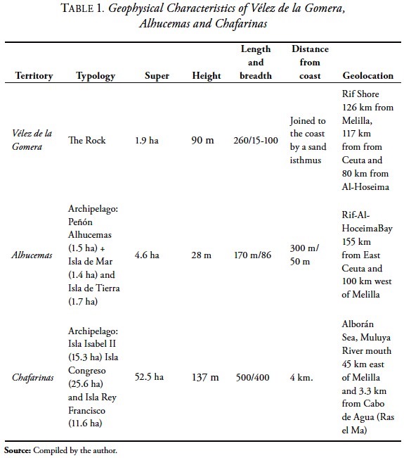
If one combines their status as "isolated islands" with the open hostility of the adjacent coasts, it is easy to understand the tremendous hardship of everyday life in the Minor Presidios (Pezzi, 1893; Gil and Gómez, 1996).
The emphasis on the conquest of Peñón de Vélez de la Gomera (1508) and its subsequent reconquest (1564) can be explained by the fact that the rock was the focus of Berber piracy in the Western Mediterranean. Located in a straight line from Málaga, it directly threatened navigation through the Straits of Gibraltar, Andalusia and the Levant coasts, constituting an enormous problem. Following Linares Quiros (1998), in addition to the island area, the Vélez Presidio included the coastal area adjacent to the Rock, where the "Cantil Fort" was located, a bulwark that made it possible to supply the garrison's water holes and cultivate certain orchards. The loss of this fort (1702) resulted in a period of enormous discomfort for the garrison, since it had to be supplied by sea from Málaga, which proved rather erratic (Sanz, 1978). Hence the succession of penalties to which those billeted there were subjected, marked by hardship, epidemics (Moga, 1995) famine and sieges (Mariñas, 1998), in addition to constant harassment (Sanz, 1978).
The Alhucemas Islands were ceded to the Spanish Crown by the Sultan of Morocco in 1560, but its de facto occupation by the Spaniards occurred later (1673), when the garrison was set up in the Peñón de Alhucemas and subsequently the prison, which, with its obviously political overtones, was the scene of a number of insurrections and dramatic situations, such as the Carlist rebellion of 1838 (Mariñas, 1998).
The latest addition to the "system" of North African enclaves was the Chafarinas Islands (1848), which, like the other minor presidios, served as a military stronghold and place of confinement, while both the garrison and the penal detachment were set up on Isabel II Island (Mir, 1980). In addition to military men and prisoners, the various public works undertaken in Chafarinas attracted civilians, fishermen and traders (Mariñas, 1998).
Chafarinas border functionality comprised a wide range of items ranging from serving as a reception and quarantine area for crews from America to providing a safe haven for those recovering from the Eastern Rif campaigns, through providing a place of exile for Cuban independence fighters. Even though this territory is linked to Melilla, with evidently complementary spatial aspects17 (Quirós, 1998), its official possession by Spain elicited France's antipathy and widespread suspicion among other European possessions with territorial ambitions in the area (Mir, 1980).
Borders with Colonial Interaction: Free Ports and Commercial Establishments
Following the Spanish victory at Wad Ras (1859) and its aftermath: the Tetuán Peace Treaty (1860) and the Madrid Trade Agreement (1861),18 a system of free ports19 was set up in both the Major and Minor Presidios (Donnet, 1912). This introduced a colonial bias into the catalogue of border functions in these enclaves that would serve, from 1863 onwards, as platforms for the expansion of mercantile activities and Spanish presence on North African soil,20 leading in the cases of Vélez and Chafarinas and Alhucemas,21 to mercantile activities with adjacent coasts, territories that would gradually be opened up to Spanish activity and influence.
Central to this new border functionality of the North African Minor sovereign territories was the progressive elimination of their penal functions, reduced during the second half of the 19th century and completely eliminated in 1907, through the transfer of prisoners to Ceuta and the closing of the penal detachments of the Minor Presidios22 (Quirós, 1998).
These circumstances had an extremely positive impact on the significant improvement in living conditions in these areas,23 fostered, in turn, by the increase in frequency-destinations of maritime transport and better communications (cable and telegraph links to Melilla). These two circumstances helped reduce the nearly total isolation characterizing life in these island peripheries.
The expansion of services for the population (housing, educational, health and administrative) coupled with the visible prosperity of the commercial activities in all the minor sovereign territories, particularly during the period from 1900 to 1920, led to an increase in the population and "civilian" life24 in all the enclaves.
This explosion of life and action is clearly reflected in the available statistical data (INE, 2012)25 shown in table 2 and graphic 1.

These tables show that the Spanish population in minor sovereign territories peaked between 1877 and 1920, when the total population of the enclaves exceeded a thousand, reached its highest point in 1919 (1536). As one can see, Chafarinas is the most populous enclave by far, exceeding 700 as opposed to approximately 400 in the others. In the case of Alhucemas, the "new era" enabled it to expand its traditional trade with the coastal cabilas (T.N. a homogenous, politically and socially independent unit occupying a set area). This territory was the site of the market place where North Africans took their produce (such as fruit and vegetables, cereals, honey, charcoal, wood, eggs and fresh meat). Alhucemas was also the port where Spanish manufactured goods bound for the neighboring coasts were unloaded. Alhucemas also established major trade links with Gibraltar (Quirós, 1998).
Until the advent of the free port, Peñón de Velez's trade with adjacent coasts had been modest, given the aggressiveness of the local cabilas towards the garrisons stationed in the fort. This hostility was linked to the limited relational capacity of these detachments. Hence the scant commercial functionality of the fort, due, on the one hand, to the low frequency of the trade that took place there,26 and secondly, to the lack of interplay between supply and demand at this site27 The result was that suppliers had little incentive to sell their goods in Peñon de Vélez, as a result of which it often went for long periods without supplies (Pezzi, 1893).
In the case of the Chafarinas Islands, trade with the coast of Kebdana was unfeasible due to the undisguised hostility of the border cabilas. However, commercial links began to be developed with the ports of French colonial Algeria, particularly Nemours and Kis.
Trade between ports, although feasible, was extremely costly since although no tariffs were levied on Spanish raw materials unloaded in Alhucemas, they were taxed once when shipped to Vélez de la Gomera and again on arrival (Quiros Linares, 1998).
As regards smuggling, according to Pastor Garrigues (2006), "irregular" trade appears to have been well established in the catchment area of the Minor Presidios. This commercial flow was tolerated (not to say encouraged) by the presidio authorities during the last third of the 19th and the early 20th centuries, at least until the Protectorate was fully established. In particular, intense, "irregular" trade took place between the forts in Alhucemas and Vélez, involving smuggled goods, particularly firearms.28 This smuggling elicited numerous complaints from the representatives of the Moroccan sultanate, given the impassivity of the fort authorities (Pastor, 2006).29
Deactivated Borders: The Advent of the Protectorate 1912-1957
Since trade between the Minor Presidios and the adjacent coast was predominantly primary (designed to cover immediate or basic needs) and timely, in terms of the frequency or volume of trade, the commercial functionality of minor forts (with the exception of Al Hucemas), was more wishful thinking than anything else, since their actual access to the mainland market was either limited or nonexistent. Changing the commercial status quo to obtain large, stable, continuous trade flows would require control of the Rifian shore. Which is why basic reception areas and proper marketing, distribution and sales points were established there. The functionality of this equipment required essential parallel transport infrastructure (such as ports, port facilities and warehouses) and communications linking existing domestic markets to the coast. The high cost of this infrastructure and equipment required the more or less peaceful "occupation" of the territory in order to be profitable. To this end, efforts focused on the establishment of the Franco-Spanish protectorate (1912-1957) in Morocco.
The advent of the Protectorate structurally altered the situation and status of the North African enclave system since the Major Sovereign Territories (Melilla and Ceuta), embarked on a period of rapid socioeconomic expansion that was particularly marked in the case of Melilla. This was due to their status as coastal urban centers, equipped with the only significant port infrastructure on this section of the North African coast at the time.
Thus Ceuta and Melilla became the main recipients of the population, commercial and monetary flows from Spain to the territory of the Spanish Protectorate. These flows were designed to set in train massive public works and major economic activities30 and establish joint Spanish-North African territorial administration, (Spanish High Commission and Majzén), for which a large budget was assigned.
By contrast, for the Minor Presidios, officially renamed Minor Sovereign Territories following the Algeciras Conference (1906), the Protectorate signified their gradual abandonment and population depletion, given the better living conditions available to their population in the Protectorate, once hostile and now Spanish. This process was influenced by their loss of military significance.
The turning point for the presence of civilians in Minor Sovereign Territories occurred during the 1920s, when, once the Rif War was over (1927), the emptying of the Minor sovereign territories began to speed up, meaning that they lost 62 per cent of their population between 1920 and 1930. The only remaining inhabitants of the enclaves were military men, civilian officials and relatives of the latter. This process was expedited during the decade from 1940 to 1950, when the overall population of the Minor Sovereign Territories was less than two hundred.
Depopulation would become the dominant trend for Minor Sovereign Territories from the 1930s onward. During the period from 1940 to 1970, this process turned the presidio "towns" into ghost towns, which they are today. The swift depopulation of the enclaves appears to be linked to the shift of commercial activities (and markets) from the islands to the mainland coast. The increase in activities was paralleled by population growth. The Spanish troops' de facto occupation of the coast adjoining the old forts therefore triggered the cycle of cause and effect.
Following Mariñas (1998), on the island of Alhucemas, its civilian population (and commercial activity) moved en masse to the new Spanish city of Villa Sanjurjo, subsequently renamed Alhucemas. A similar case occurred in Vélez de la Gomera, when its civilian inhabitants, having proved the advantages of the new situation, did not hesitate to move to the promising new locations of Puerto Capaz, Torres de Alcalá, Río Martín and Tetuán. In Chafarinas, commercial activity shifted to Cabo de Agua (Ras el Ma), where trade was conducted. This "physical" depopulation, combined with the lack of interest of successive governments during the first half of the 20th century, led to the virtual "dismantling" of the Minor Presidios in the 50s.
Reactivated Borders: Military and Environmental Functionalities (1957-1995)
In the wake of Morocco's independence, (1957), the Minor Sovereign Territories recovered their border status and functionality, reinforcing the garrison detachments (sometimes accompanied by the families of officers and NCOs) and the presence of certain civilians (and their families), usually public employees (such as lighthouse keepers, telegraph clerks, postmen, teachers, bakers and mechanics), ensuring contact between the Major and Minor Sovereign Territories (and the peninsula) through a sea route, with supply and passenger ships linking Ceuta and Melilla to the islands and rocks. This line persisted until the mid-1980s, when, following the entry into force of the Meta Plan (1985), supplies were provided on a weekly basis by military helicopters, supplemented if necessary by boats.
Due to technological advancement coupled with the automation of lighthouses and communications in the late 20th century, islands and islets gradually lost their last civilian residents, which were now unnecessary, leaving only the remaining military personnel, dedicated specifically to guarding and protecting these territories, though increasingly fewer soldiers and civilian staff, a somewhat incomprehensible situation that persists to this day.
Despite their depopulation, the spatial and border functionality of the Minor Sovereign Territories continued undeterred throughout the period from 1957 to 1995, adding new functionalities to the catalogue such as environmental protection,31 particularly active in the Chafarinas Islands, initially declared a National Hunting Refuge (1982), renamed, Special Bird Protection Zone (ZEPA, 1989) and eventually called Place of Community Importance for the Natura Network 2000 (LIC, 2006).32 This obvious ecological wealth has led to the installation of a biological station (complete with scientific and administrative staff), managed by the Autonomous National Parks' Organization, which ensures their conservation and public use from Madrid. During this period, only the presence and experiences of the detachments stationed there (Gonzalo, 2012) or the discovery of a new botanical or zoological species (Tena, 1996; Villora, 1993; Emig et al., 1999), in its rich maritime and terrestrial ecological environment drew the micro archipelagos out of the oblivion into which they had been cast.
EU External Borders: Territorial Control and Migratory Pressure, 1995-2012
Following Spain's incorporation into the EEC, the Spanish-Moroccan border became the external border of the European Union (Driessen, 1996; Ferrer-Gallardo, 2007) , the only European border on the African continent. For the Major or Minor Sovereign Territories, this circumstance translated into an accentuation of their status as a secular border, producing "rebordering" to use the terminology of Lois and Cairo (2011), linking the European mainland dimension to the Spanish-Moroccan bilateral dimension.
In specific (everyday) terms, "rebordering" has involved, on the one hand, a tendency towards the stiffening of border controls, whether land or maritime, in response to immigration and illegal trafficking (Lois and Cairo, 2011; Ferrer-Gallardo, 2008), which was exacerbated following Spain's incorporation into the Schengen Community Space (1991), when the famous fences33 emerged around the land border perimeter of the cities of Ceuta and Melilla. For their part, in the maritime border areas, a sort of "technological fence" has been set up, the Integrated External Surveillance System (SIVE) (Carling, 2007a/b; Ferrer-Gallardo, 2008) . Implementation of these fences, whether metallic or technological, has caused a certain amount of controversy, due both to their high costs and their apparently negligible results (Carling, 2007a/b; Ferrer-Gallardo, 2008), since they have failed to reduce migratory flows despite exacting a high (sometimes extremely high) humanitarian toll.34
At the same time, "rebordering" appears to have triggered an escalade of claims by the Kingdom of Morocco regarding the "Moroccanness" of the set of Sovereign Territories, creating a sort of Moroccan claim fever regarding the Major and Minor Sovereign Territories, and producing a series of border incidents implemented by groups of Moroccan nationalists who have arrived and even symbolically "invaded" Peñón de Vélez de la Gomera (EFE, 2012a). These incidents have led to disturbingly frequent diplomatic friction and disagreements in recent years.
In the case of the Minor Sovereign Territories, "rebordering" has translated into the acceleration of (thitherto unknown) migratory pressure on islands and rocks (EFE, 2012b), reflected in the constant arrival of small vessels in Chafarinas and the Islands of Alhucemas, particularly Isla de Tierra.35 This has elicited the swift activation of migratory border control functions on the islets, coupled with an increase in the presence of police and civil guards in the area (Sánchez, 2012), together with existing maritime rescue devices (maritime rescue, etcetera). This has sparked yet another incident of diplomatic "friction" with the adjacent Kingdom of Morocco (Cembrero, 2012a).
REFLECTIONS AND CONCLUSIONS
Within the set of Spanish-North African border territories (Sovereign Territories) the "Minor Sovereign Territories," border enclaves located on the Moroccan Mediterranean shore are particularly intriguing. These locations perfectly embody Spain's peculiar historic North African experience, reflecting this strange, contradictory zigzag of the Spaniards in this inhospitable part of North Africa. It is contradictory, in that Spanish presence has historically been constructed, in equal measure, with progress on the one hand and setbacks on the other, reflecting as a whole a dynamic of missteps that could end up leading nowhere, given the urgent challenges facing the former Hispania, such as globalization, the challenges of the Euro and the integration (or otherwise) of Europe. This juxtaposition of circumstances requires focusing attention and scant resources in the areas where they will prove most effective.
The evolution of the historical coordinates in which the Minor Sovereign Territories arose, combined with the re-interpretation of the border event undertaken throughout the 20th century, has conditioned the past and present development of these border lands, obliging them and their inhabitants to constantly adjust and readapt their catalogue of border functions to these ups and downs and changes. In this respect, over the past five centuries, the old North African Minor Forts have developed an entire functional catalogue, in which various functions have alternated and followed on from each other, in keeping with the historical moment of reference and the dominant geopolitical and geostra-tegic trends.
As a whole, the range of functionalities have spanned the historic roles of watchtower, protection and custody of the African Border, the control of Berber piracy, curbing Turkish expansion and serving as a place of exile and penal confinement to 19th century functions such as factories or colonial-commercial platforms, together with the modern functions of the control, surveillance and supervision of migratory flows targeting Europe, environmental conservation and protection and the vigilant or alert presence (given the high potential for conflict of Mauritania-Tingitania) of Europe (and Spain) in Africa.
The current importance of these small island enclaves in the news is due as much to the dramatic, accelerated migratory pressure exerted on them (as Spanish and European territories) as to the increase in Morocco's claims to them. This twofold, growing pressure has begun to create a certain state of pressure around the Minor Sovereign Territories, concern over their problematic present since they and their older sisters (Ceuta and Melilla) constitute a constant source of friction (and potential confrontation) with the Kingdom of Morocco), one of Spain's main trading partners (both present and above all, future). This is a realistic concern, given the border fragility and precariousness of these locations, which are indefensible in military terms, given their proximity to the Moroccan coast, a ffew yards in the case of the Alhucemas Island or "stuck" directly to the coast as in the case of Vélez de la Gomera. This territorial "adjacency" to Morocco severely restricts the physical demarcation of its maritime and land border line with the neighboring country.
If one adds to the previous circumstances: the lack of population (excluding military men and biologists), the absence of economic activities in situ and the shortage of transborder relations with the Moroccan border surroundings, the problematic matrix of the Minor Sovereign Territories can be said to be highly complex, given that the confluence of the various factors reviewed has created a sort of socio-economic and relational vacuum around them, which could severely complicate Spain's continuity in these territories, if a cost-benefit variable is introduced into the analysis. Given the high cost of their maintenance at a time like the present, with enormous budgetary pressure for the Spanish nation and worse still, a fairly traumatic horizon of a contraction in public spending.
It is therefore extremely difficult to predict or even suggest the medium and long-term future of these old, forgotten borders, given the complex three-way problem (or four-way if one includes the United States as a player) existing in the Mauritanian-Tingitania zone where they are located.
At the same time, the (more or less overt lack of interest) Spanish public opinion appears to show in this significantly reduces the possibility of a solution to their problems. This disinterest might appear unusual or even shocking from a historical perspective (or for a neutral observer) yet it is fairly logical in a Spain obsessed by more prosaic, worrying everyday issues, derived from the political, economic and social crisis the country is suffering (which also threatens to deactivate it). Thus, although there are favorable opinions regarding the value of the Minor Sovereign Territories (Del Valle, 2011), the majority (or vast majority) appear to be oriented, in the short term, towards placing these island enclaves and their problem in a distant attic, preferably lost in time and space.
REFERENCES
Alonso Acero, Beatriz, 2003, Orán y Mazalquivir en la política norteafricana de España (1589-1639), Doctoral dissertation supervised by Dr. José Alcalá-Zamora y Queipo de Llano, Madrid, Universidad Complutense. [ Links ]
Anderson, James, 1995, "The exaggerated death of the nation-state", In J. Anderson, C. Brook, & A. Cochrane, edits., A Global World?, Oxford, Oxford University Press, pp. 66-86. [ Links ]
Arqués, Enrique, 1966, Las adelantadas de España: Las plazas españolas del litoral africano del Mediterráneo, Madrid, CSIC, Instituto de Estudios Africanos. [ Links ]
Cairo Carou, Heriberto, 2001, "Territorialidad y fronteras del estado nación: las condiciones de la política en un mundo fragmentado", Revista Política y Sociedad, No. 36, pp. 29-38. [ Links ]
Cajal, Máximo, 2003, Ceuta, Melilla, Olivenza y Gibraltar ¿Donde acaba España?, Madrid, Siglo XXI Editores de España. [ Links ]
Calderón, Francisco José [ebook], 2008, Fronteras, iedentidad, conflicto e interacción. Los Presidios Españoles en el Norte Africano, author's edition, available at <http://www.eumed.net/libros/2008c/433/index.htm>, last accesed on September, 2012. [ Links ]
Calderón, Francisco José, 2010, "La Raya luso-hispana, una frontera en transición", Proceedings of International Algarve-Alentejo Andalucía Transborder Cooperation, Congress CBC, Huelva, Publications Service of the Universidad de Huelva, pp. 41-54. [ Links ]
Calderón, Francisco José, 2011, "Presidios, mestizajes y fronteras: referencia entre la Nueva España y la Vieja África", Revista Tecsistecatl, vol. 3, núm. 11, December, available at <http://www.eumed.net/rev/tecsistecatl/n11/fjcv.html>, last accesed on September, 2012. [ Links ]
Carcaño Mas, Francisco et al., 1991, Melilla, rifeñerias: Las plazas menores de Africa, Melilla, Fundación Municipal Sociocultural,/Ayuntamiento de Melilla. [ Links ]
Carling, Jørgen, 2007a, "Migration control and migrant fatalities at the Spanish-African borders", International Migration Review, Vol. 41, No. 2, pp. 316-343. [ Links ]
Carling, Jørgen, 2007b, "The Merits and Limitations of Spain's High-Tech Border Control", Migration Information Source, Washington, DC, Migration Policy Institute, available at <http://www.migrationinformation.org/Feature/display.cffm?id=605>, last accessed on 2 September, 2012. [ Links ]
Cembrero, Ignacio, 2012a, "Marruecos protesta por la presencia de guardias civiles en Chafarinas", in El País, section "Política", July 12, available at <http://politica.elpais.com/politica/2012/07/12/actualidad/1342095357_948269.html>, last accessed on September 5, 2012. [ Links ]
Cembrero, Ignacio, 2012b, "Peñones e islotes: la nueva entrada de los 'sin papeles' en España", in El País, section "Política", August 25, available at <http://politica.elpais.com/politica/2012/08/25/actualidad/1345911736_115632.html>, last accessed on September 5, 2012. [ Links ]
Del Valle Gálvez, Alejandro, 2011, "Ceuta, Melilla, Chafarinas, Vélez y Alhucemas: tomar la iniciativa", Real Instituto Elcano, Madrid, Fundación Real Instituto Elcano, available at <http://www.realinstitutoelcano.org/wps/portal/rielcano/contenido?WCM_GLOBAL_CONTEXT=/elcano/elcano_es/zonas_es/mediterraneo+y+mundo+arabe/ari163-2011>, last accessed on September 7, 2012. [ Links ]
Donnan, Hastings and Thomas Wilson, 1999, Borders: Frontiers of Identity, Nation and State, Oxford, Berg. [ Links ]
Donnet y Pareja, Baldomero, 1912, "Los puertos de España en África", Revista de Obras Publicas, Madrid, publicación técnica del cuerpo de ingenieros de caminos, canales y puertos, year 60, No. 1931, pp. 465- 469, available at <http://ropdigital.ciccp.es/pdff/publico/1912/1912_tomoI_1931_01.pdf>, last accessed on September 7, 2012. [ Links ]
Driessen, Henk, 1992, On the Spanish Moroccan frontier: A study in ritual, power, and ethnicity, New York/Oxford, Berg. [ Links ]
Driessen, Henk, 1996, "At the edge of Europe: crossing and marking the Mediterranean divide", in L. O'Dowd, & T. Wilson, edits., Borders, nations and states, Aldershot, Hampshire, UK, Avebury Publishers, pp. 179-198. [ Links ]
EFE, 2012a, "Cuatro activistas marroquíes detenidos por tratar de 'ocupar' el Peñón de Vélez", in 20minutos.es, August 29, available at <http://www.20minutos.es/noticia/1573714/0/activistas-marroquies/ocupar/penon-de-velez/>, last accessed on September 1, 2012. [ Links ]
EFE, 2012b, "Islas y peñones el nuevo frente de la inmigración en España", en La Razón, section "Asuntos Sociales", September 2, available at <http://www.larazon.es/noticia/6488-islas-y-penones-el-nuevo-frente-de-la-inmigracion-en-espana>, last accessed on September 3, 2012. [ Links ]
Emig, Christian et al., 1999, "The occurrence in the Chafarinas Islands (S.E. Alboran Sea, western Mediterranean) of four species of Phoronida (Lophophorata) and their distribution in the north-eastern Atlantic and Mediterranean areas", Cahiers Biologie Marine, Roscoff, Station Biologique de Roscoff, Vol. 40, No. 2, pp. 129-133. [ Links ]
European Commission, 2003, "Paving the way for a New Neighbourhood Instrument", COM(2003) 393 final, Brussels, Commision of the European Communities, July 1, available at <Instrument http://ec.europa.eu/world/enp/pdf/com03_393_en.pdf>, last accesed on September, 2012. [ Links ]
Ferrer-Gallardo, Xavier, 2007, "Acrobacias fronterizas en Ceuta y Melilla. Explorando la gestión de los perímetros terrestres de la Unión Europea en el continente africano", Documentos de Análisis Geográfico, No. 51, 2008, pp. 129-149. [ Links ]
Ferrer-Gallardo, Xavier, 2008, "The Spanish-Moroccan border complex: Processes of geopolitical, functional and symbolic rebordering", Political Geography, No. 27, pp. 301-321, available at <http://geografia.uab.es/migracions/cas/publicacions%20i%20documents/Ferrer,%20The%20spanish-moroccan%20border%20complex.pdff>, last accessed on September 5, 2012. [ Links ]
García Arenal, Mercedes and Miguel Ángel DE BUNES, 1992, Los españoles y el Norte de África, Siglos XV-XVIII, Madrid, Mapffre. [ Links ]
Gil Ruiz, Severiano y Miguel Gómez Bernardi, 1996, Melilla: Apuntes de su historia militar, Melilla, Ediciones V Centenario. [ Links ]
Gold, Peter, 1999, "Immigration into the European Union via the Spanish enclaves of Ceuta and Melilla: a reflection of regional economic disparities", Mediterranean Politics, Vol. 4, No. 3, pp. 23-36. [ Links ]
Gonzálo, Beatriz, 2012, "Hacer las islas", Tierra, Boletín informativo del Ejército español, Year 27, No. 198, May 24, pp. 8-9. [ Links ]
Instituto Nacional de Estadística (INE), 2012, Censos Oficiales de la Población de 1877-1970, Fondo Documental del Instituto Nacional de Estadística, available at <http://www.ine.es/inebaseweb/libros.do?tntp=71807>, last accesed on September, 2012. [ Links ]
Llorente de Pedro, Pedro Alejo, 2008, "La pena de presidio en las plazas menores africanas hasta la Constitución Española de 1812", Anuario de Derecho Penal y Ciencias Penales, España, Boletín Oficial del Estado, No. LXI, January 2008, pp. 265-330. [ Links ]
Lois, Maria and Heriberto Cairo, 2011, "Introducción. Desffronterización y re-fronterización en la Península Ibérica", Geopolítica(s), Revista de estudios sobre espacio y poder, Vol. 2, No. 1, pp. 11-22. Monográfico: "Las Fronteras Ibéricas". [ Links ]
Lourido Díaz, Ramón, 1996, "Españoles en el Norte de África en la Edad Moderna", in B. López García, coord., Atlas de la inmigración magrebí en España, Madrid, Universidad Autónoma de Madrid, pp. 22-26. [ Links ]
Mariñas Otero, Eugenio, 1998, "Las Plazas menores de soberanía española en África", Militaria, Madrid, UCM Publication Services, No. 12. [ Links ]
Mir Berlanga, Francisco, 1980, "Las Islas Chafarinas. Historia del archipiélago de Chafarinas", Jábega, Málaga, Ed. de la Diputación de Málaga, No. 32, pp. 51-54. [ Links ]
Moorhead, Max, 1975, The Presidio, Bastion of the Spanish Borderlands, United States, University of Oklahoma. [ Links ]
Newman, David, 2006, "The lines that continue to separate us: Borders in our borderless world", Progress in Human Geography, SAGE Publications, Vol. 30, No. 2, pp. 1-19. [ Links ]
Newman, David and Anssi Paasi, 1998, "Fences and neighbours in the postmodern world: boundary narratives in political geography", Progress in Human Geography, SAGE Publications, Vol. 22, No. 2, pp. 186-207. [ Links ]
O'Dowd, Liam, 2010, "From a 'borderless world' to a 'world of borders': Bringing history back in", Environment and Planning D: Society and Space, Vol. 28, No. 6, pp. 1031-1050. [ Links ]
Ohmae, Keinichi, 1990, The Borderless World, London, Collins. [ Links ]
Pastor Garrigues, Francisco Manuel, 2006, España y la apertura de la cuestión marroquí(1897-1904), Doctoral dissertation. Morales Lezcano, V. (Dir.) Universidad de Valencia, Departamento de Historia Contemporánea, available at <http://rodrigo.uv.es/bitstream/handle/10550/15215/pastor.pdf?sequence=1>, last acccessed on September 7, 2012. [ Links ]
Pezzi, Rafael, 1893, Los presidios menores de áfrica y la influencia española en el Rif, Madrid, Fortanet. [ Links ]
Powell, Philip Wayne, 1982, "Genesis of the Frontier Presidio in North America", The Western Historical Quarterly, Vol. 13, No. 2, pp. 125-141. [ Links ]
Quirós Linares, Francisco, 1998, "Los Peñones de Vélez de la Gomera y Alhucemas y las Islas Chafarinas", Ería, Oviedo, Universidad de Oviedo, No. 45, pp. 54-66. [ Links ]
Sánchez Doncel, Gregorio, 1991, Presencia en España en Orán (1509-1792), Toledo, Estudios Teológicos de San Ildefonso. [ Links ]
Sánchez, Paqui, 2012, "La Guardia Civil blindará las Chafarinas contra el tráfico de drogas e inmigrantes", in El Mundo, section "Melilla", September 7, available at <http://www.elmundo.es/elmundo/2012/07/09/espana/1341837758.html>, last accessed on September 8, 2012. [ Links ]
Sanz Sampelayo, Juan Félix, 1978, "Los presidios españoles del Norte de África y su aprovisionamiento de víveres a fines del siglo XVIII", Anuario de Historia Contemporánea, No. 4-5, pp. 101-126. [ Links ]
Saruel Hernández, Fernando, 2008, "El Peñón de Vélez de la Gomera en un manuscrito de 1845", Akros: La revista del museo, No. 7, pp. 49-52. [ Links ]
Tena Medialdea, José [dissertation], 1996, Faunística y ecología de los anélidos poliquetos de los fondos de sustrato duro del Archipiélago de las Chafarinas (S.W. Mar de Alborán), Universidad de Valencia. [ Links ]
Ubieto, Antonio et al., 1970, Introducción a la historia de España, Barcelona, Teide. [ Links ]
Van Houtum, Henk and Anke Strüver, 2002, "Borders, Strangers, Doors and Bridges", Spaces & Polity, Vol. 6, No. 2, pp. 141-146. [ Links ]
Velasco, Juan Carlos, 2007, "Fronteras e inmigración: la sima entre España y África", Bottup.com, available at <http://bottup.com/200708151649/Ciudadania/la-frontera-entre-espa-marruecos-es-una-de-las-mradicales-del-mundo.html#ixzz24ghVGV9U> [ Links ].
Vilar, Juan Bautista and Ramón Lourido, 1994, España y el Magreb. Siglos XVII-XVIII, Madrid, Mapfre. [ Links ]
Villora Moreno, Santiago [dissertation], 1993, "Heterogeneidad del ambiente intersticial y biodiversidad de la meiofauna: el meiobentos de las islas Chafarinas", Universidad de Valencia. [ Links ]
Vives González, Luna, 2011, "White Europe: an alternative reading of the Southern EU border", Geopolítica(s), Vol. 2, No. 1, pp. 51-70. [ Links ]
1 The term "border" implies the control of a concrete territorial zone by a specific, unique human community. By separating it from adjacent communities, this limit produces a division between "us" and "them," the cornerstone of both collective identity and the construction of a nation.
2 In fact, the etymology of the term "border" ("frontera" in Spanish) is "front," in other words, the front that designated the zone of contact and separation from an enemy even though it is a fluctuating line that evolves as a function of the correlation of forces between parts.
3 In the European Union, the rethinking of the border has reconfigured borders (between member countries) as spaces of interaction-connection between adjacent territories and thresholds of flows entering or leaving the territory (European Commission, 2003). It consists of a permeable vision of boundaries, oriented towards the organization of transborder flows, whether mercantile, commercial, human, touristic or migratory.
4 Cities administratively classified as Autonomous Cities. They are medium-sized border cities with a small area: Ceuta (19.4 km2) and Melilla (13.4 km2).
5 The Chafarina Island archipelago consists of three islands: Isla del Congreso (4.5 knr*), Isla Isabel II, (2 km2) and Islote Rey Francisco (0.6 km2).
6 The microarchipelago of Alhucemas comprises "Peñón de Alhucemas" (0,015 km2), "Isla de Tierra" (0.017 km2) and "Isla de Mar" (0.014 km2).
7 Peñón de Vélez de la Gomera (2.2 km2) was originally an island but in the wake of a powerful earthquake in 1934, became a sort of peninsula and is currently linked to the shore by a small, sandy isthmus.
8 In order for a territory to be regarded as an enclave, it must be completely surrounded by the territory of another state. In other words, it must be physically "locked" inside it. This situation does not occur in our case, since the Major Sovereign Territories are open to the sea while the Minor Sovereign Territories are surrounded by the sea. An alternative terminology would be "exclave" or "semi-enclave" (Ferrer, 2007). Another issue is the fact that widespread use of the term means it has been broadly accepted as a common code.
9 Such as the problem of the control of the Straits of Gibraltar or the fight against extremist Islam, which transcend the purely bilateral sphere.
10 As with all types of border problems and friction that lead to the mutual withdrawal of ambassadors, a common tactic during this period (2000-2011).
11 The Moroccan Constitution (2011) calls for the authentic frontiers of the "Great Morocco," a position that led to a permanent attitude of territorial demands targeting Spain.
12 This action elicited a Spanish military reaction, which involved capturing Moroccan military men by armed forces. This war led to the virtual severing of diplomatic (although not economic) relations between Spain and Morocco.
13 A stage of enormous danger for the southwest peninsular shore, which suffered razzias and raids by Berber pirates and the Turkish expansion in the Mediterranean. Circumstances which, linked to the fear of a large-scale Moorish rebellion in the peninsular south and Levant created an enormous sense of insecurity in the emerging Castillian-Aragonese Kingdom, leading to the need to guarantee their territorial security and integrity.
14 These operations led to the capture of Melilla (1497), Mazalquivir (1505), the Peñón de Vélez de la Gomera (1508), Orán (1509), Bujía, Trípoli and the subjection of Algiers (1510). After various North African counterattacks, the African border around the enclaves of Oran-Mazalquivir, Melilla, Vélez del Gomera and Ceuta (subsequently a Portuguese possession until 1640); the Alhucemas Islands were subsequently incorporated into this peculiar "system." (1673). The double fort of Oran-Mazalquivir was abandoned in 1792. Meanwhile, the Chafarinas Islands were incorporated in 1847. This led to the set of "North African forts" as we know them today: Ceuta, Melilla, Peñón de Vélez de la Gomera, Alhucemas Islands and Chafarinas Islands.
15 The term "presidio" can be confusing, since in modern-day Spanish, the term is equivalent to "prison" or "correctional center" whereas in fact it means "fort" or "bastion" located on the borders of the territory.
16 A distinction must be made between exiles, dedicated to the service of arms and convicts dedicated to the construction and maintenance of the forts.
17 Since the inhabitants of Melilla used the islands as an area for leisure and recreation and catching shellfish. The Chafarinas Islands were used as quarries (for extracting stone for construction work or as a port of refuge when, in the event of a storm, it proved difficult to berth in the port of Melilla.)
18 These asymmetrical treaties were very important since their stipulations established, on the other hand, the current delimitation of the Spanish-Moroccan border and on the other, they created a commercial "open door" regime, similar to that currently enjoyed by England in the area, albeit more restrictive, enabling Spanish products to gain free access to the Moroccan market, as a result of extremely low tariffs.
19 Established by the Ministry of Finance Law on May 18, 1863.
20 A very different role from that of the "African border." The old presidios would no longer be regarded simply as "stockades" designed to "curb, contain and control" the Berbers and Turks or to house prisoners. Henceforth, their mission would be to open up the North African market to Spanish exports.
21 Following Eugenio Mariñas (1998), El Peñón de Alhucemas was the only minor fort to engage in intense trade with the North African population in the adjoining area, the kingdom of Nekor. The flourishing trade in the 17th and 18th centuries focused on products such as textiles, salted food, oil and rice among others, from the Peninsula with products from the area such as pickles, wax, raisins, and almonds, creating an abundance of civil population.
22 At the same time, Ceuta Prison was finally closed down in 1911.
23 Vélez, Alhucemas and Chafarinas experienced a "civil-urban expansion" of the Tertiary: in Vélez de la Gomera, there would be shops, businesses and bars. In Alhucemas, branches of banks, boat consignment offices and even a Recreation Circle were opened up. Chafarinas, a "white town" par excellence (with businesses, a theater and a casino) developed as a result of construction work, fishing and trade, etc.
24 Municipal administration of the Minor Sovereign Territories was undertaken by a combined civic-military organization, called an "Excise Board," comprising civilians and military men, which served as a Town Hall and of which the Military Commander of the area was President (Mayor).
25 Taken from the state population censuses of the period from 1877 to 1970.
26 In Peñón de Velez, the border cabila residents only visited the fortress in times of relative peace, usually every month, setting up a small market offering cattle, poultry, eggs, fruit and vegetables that were purchased by the inhabitants of Peñón.
27 Market prices, set by the Military Governor of Peñón de Vélez, remained constant. Moreover, mechandise and food were divided up among the inhabitants of The Rock by peculiar system of distribution, as a function of categories, which led to their fair distribution as a function of the volume to be divided up.
28 The famous Winchester and Remington automatic rifles, whose proliferation among the locals led to the swift loss of authority of the Majzén over the local cabilas.
29 According to Pastor (2006:298-299), Spanish authorities alleged that since they were free ports: "Military authorities could not impose any restrictions or constraints on the boats that came into them every week to unload legally consigned merchandise destined for established tradesmen or individuals in the areas. At the same time, the Army was not authorized to intervene in the free trade undertaken in the garrisons."
30 The point was to develop transport infrastructure (through the construction of highways, bridges, roads, railroads, ports, aerodromes, etc.), urban development (construction of cities and urban nuclei), communications infrastructure (telephony, telegraphy networks and postal service) and basic health and education facilities, thitherto non-existent in the area. As for productive activities, mining production expanded significantly. Likewise, agrarian and livestock production increased steadily until the end of the Protectorate (1958).
31 The islands and the surrounding marine rectangle providing a sanctuary for wildlife, were of unquestionable environmental value. The world's second largest colony of the Audouin Seagull (Larus Audouinii) nest in Chafarinas, with over 2000 breeding pairs). The islands are also home to a large contingent of the rare Cory's Shearwater. These islands also contain a significant breeding nucleus of the rare osprey. Lastly, it contains marine invertebrates in danger of extinction, such as the limpet (Patella ferruginea).
32 The incorporation of Chafarinas into the Network of European Natural Spaces, such as LIC, with a Maritime-Land area of 511 ha, is due, according to the Habitats guidelines (EU) (1991) to the existence in the island enclave of types of habitat of community interest together with contextual flora and fauna of extraordinary value, whose conservation requires the designation of Special Conservation Zones.
33 A double metal fence (triple on the Melilla border perimeter) between 3.5 and 6 m high equipped with high-tech surveillance equipment (infrared cameras, thermal sensors, etc.) and of course the ubiquitous barbed wire.
34 On land, the armor-plating of the border perimeter has heightened the despair of thousands of Sub-Saharans who gather near the border, waiting for an opportunity to attack the fences. This occurs periodically, resulting in death and injury. In the case of the sea, the introduction of SIVE has deviated the migratory traffic in the Straits of Gibraltar, driving smaller vessels (known as pateras) into uncontrolled alternative routes, considerably increasing the danger of the migratory route.
35 This islet can be reached by swimmers or even walkers at low tide, since it is 10-30 meters from the Moroccan shore.

