


 nova página do texto(beta)
 Inglês (pdf)
 Artigo em XML
 Referências do artigo
 Enviar este artigo por email
 Citado por SciELO
  Similares em
SciELO
Similares em
SciELO 
 Permalink
Introduction
Spigelia L. is endemic to the Americas, with the greatest diversity in the tropical areas (Gould, 1997). Around 90 species are recognized, distributed from the southeastern United States of America to northern Argentina (Bravo, 1971; Gould, 1997; Stevens, 2001; Fernández-Casas and Huft, 2009; BFG, 2015). Spigelia can be distinguished from the other genera of Loganiaceae on the continent (Bonyunia R.H. Schomb. ex Progel, Mitreola L. and Strychnos L.), by its herbaceous or small shrubby habit, with opposite or sometimes pseudowhorled leaves below the inflorescence, interpetiolar stipules, inflorescences in scorpioid cymes, with sessile or subsessile flowers, bilocular capsule, with a persistent metastyle (basal portion of the style) and loculicidal, septicidal and circumscissile dehiscence at the same time, which allows the dispersal of the seeds (Henrickson, 1996; Alvarado-Cárdenas, 2007; Fernández-Casas, 2009).
Spigelia has two centers of diversity on the continent: Brazil and Mexico (BFG, 2015; Islas-Hernández et al., 2017a, b; Islas-Hernández and Alvarado-Cárdenas, 2020). Its distribution, despite being continuous throughout the continent, presents an important separation in the components of its diversity, with a group in North/Central America/the Caribbean (NA) and another group in South America (SA). There are 22 species exclusive to NA, 55 are exclusive to SA and seven shared species; two of them are widely distributed from Mexico to Argentina (Bravo, 1971; Gould, 1997; Fernández-Casas and Huft, 2009; BFG, 2015). However, the systematic knowledge of the group is limited or outdated in regional taxonomic treatments (Gibson, 1969; Bravo, 1971; Fernández-Casas, 2003b, 2009; Alvarado-Cárdenas, 2007; Fernández-Casas and Huft, 2009; Islas-Hernández and Alvarado-Cárdenas, 2017, 2018), which do not include the species published in the last ten years, as well as new distribution records.
The aim of this work is to generate a taxonomic review of Spigelia species, distributed in North America, Central America, and the Caribbean (NA). Likewise, novel information on the morphology of the group, a detailed description of the genus, a key for the identification of the species and diagnostic descriptions of the species are presented. Information on its distribution by country and maps of its known distribution in the study area are also included.
Material and Methods
The research was carried out by an exhaustive search of bibliographic information published between 1900 and 2023, to know the number of published and accepted species that are distributed in North America, Central America, and the Caribbean (NA). The bibliographic databases consulted were Google Scholar (2022), Scopus (2022), SciELO (2022), and Web of Science (WoS, 2022). The following keywords were used for the search: "Spigelia", "Loganiaceae", "new species", "North America and America", and "Central America and Mexico".
Subsequently, a review of herbaria in Mexico (CICY, ENCB, FCME, FEZA, HGOM, HUAA, HUAP, HUMO, IBUG, IEB, IMSS, INEGI, MEXU, OAX, QMEX, SERO, UAMIZ, XAL), USA (MO, NY, TEX, US), and Ecuador (QCNE) was carried out (acronym citation follows Thiers (2023)). Specimens were collected in Mexican states of Oaxaca, Puebla, Querétaro, and Veracruz between 2015-2022 (deposited in FCME and MEXU). Virtual collections, such as Global Plants (JStor, 2023), NY (NYBG, 2023), and MO (TROPICOS, 2023) were consulted to obtain information on morphological characters for the taxonomic treatment and detailed description of the traits, as well as geographic information on their known distribution.
A total of 3500 specimens deposited in 23 herbaria were reviewed, including 21 types specimens, besides 15 images of types in virtual collections to obtain the vegetative, flora, palynological and carpological characters. The taxonomic treatment includes the synonymy of the species, with a description, as well as taxonomic keys for all species distributed in NA, divided by their distribution in USA, Mexico, and Central America/the Caribbean. The morphological information obtained from the herbarium specimens allowed us to obtain the measurements and details of the structures for the descriptions, integrating information on characters that had not been previously described and with taxonomic importance to separate between species. However, in some cases, especially in those when only the type material was available, not all morphological data could be obtained. Vegetative, reproductive and dispersal characters are described, based on previous works on the genus (Gould, 1997, 1999; Alvarado-Cárdenas, 2007; Fernández-Casas and Huft, 2009; Alvarado Cárdenas and Jiménez Ramírez, 2015; Islas-Hernández et al., 2017a; Islas-Hernández and Alvarado-Cárdenas, 2017, 2018, 2020), as well as observations of fresh material and herbarium specimens.
The images of the species were obtained from specimens from different herbaria (FCME, IBUG, IEB, MEXU, SERO, US) and photographs from the Naturalist (Naturalista, 2021a) database. Acetolysis was performed on the pollen grains of species with available structures to obtain the characters included in the morphological data matrix. The processed samples were photographed with a Hitachi Scanning Electron Microscope (SEM; Model SU1510 at 10 kV, Japan) to have detailed descriptions of the micromorphological structures of the pollen.
To know in detail some floral structures, to complement the genus description, anatomical sections were made of flowers of Spigelia humboldtiana Cham. & Schltdl. and S. splendens Hort. Wendl. ex Hook., of which material was preserved in alcohol 70%. The flowers were fixed in Glyco-Fixx for two weeks and dehydrated in a series of ethanol (Johansen, 1940) to be embedded in paraffin and sectioned longitudinally and transversely into 12 µm thick segments on a semiautomatic rotation microtome (Leica RM2165, Vienna, Austria). The sections were stained by the quadruple technique of Johansen (1940) and the safranin-fast green technique. They were later mounted on synthetic resin and photographed under a microscope (Leica DM750, Vienna, Austria), with a digital camera (Leica ICC50 E, Vienna, Austria).
With all the vegetative, floral, palynological, and carpological data captures in a database, separating each of the important structures, and with the help of the monographaR package (Reginato, 2016), on the R platform (RC Team, 2013), we obtained the descriptions included in the taxonomic treatment. We followed the species concept of Templeton (1989) to contrast among the similar taxa. The concept suggests different cohesion factors among the individuals that belong to a species. In addition to genetic factors, it proposes phenotypic constraints and habitat distinctiveness. The latter two are applied throughout the synopsis in the species key and taxonomic remarks.
The geographic information of the herbarium specimens was processed through ArcMap v. 10.5 (ESRI, 2010) to obtain the distribution maps included in the synoptic treatment. In addition, the known distribution of the species was analyzed through the GeoCAT program (Bachman et al., 2011). This program allows the generation of risk categories following the criteria of the IUCN Red List (Foden and Young, 2016), based on the Extension of Occurrence (EOO) and the Area of Occupancy (AOO). The results of these analysis were complemented with the information of the habitat to suggest the preliminary risk categories.
Results
Of the nearly 90 species of the genus Spigelia, 29 are reported to occur in North America, Central America, and The Caribbean (Table 1). The genus is homogeneously distributed throughout the NA region, but with an important variation in the number of species present per country (Fig. 1A). Mexico has the greatest diversity with 23 species, followed by the United States of America and Guatemala with six species each, and Costa Rica with five (Fig. 1B).
Table 1: Species of the genus Spigelia L. distributed in North America, Central America, and the Caribbean with their distribution by country. Abbreviations: BHS=Bahamas, BLZ=Belize, CRI=Costa Rica, CUB=Cuba, DMA=Dominica, DOM=Republica Dominicana, GTM=Guatemala, HND=Honduras, JAM=Jamaica, MEX=Mexico, NIC=Nicaragua, PAN=Panama, SLN=El Salvador, USA=United States of America.
| Species | Distribution |
|---|---|
| Spigelia ambigua C. Wright | CUB |
| Spigelia anthelmia L. | BHS, BLZ, CRI, CUB, DMA, DOM, SLN, GTM, HND, JAM, MEX, NIC, PAN, USA |
| Spigelia ayotzinapensis L.O. Alvarado, S. Islas & Bustam. | MEX |
| Spigelia carnosa Standl. & Steyerm. | SLN, GTM, MEX |
| Spigelia chiapensis K. Gould | MEX |
| Spigelia coelostylioides K. Gould | GTM, MEX |
| Spigelia colimensis Fern. Casas | MEX |
| Spigelia dolichostachya Fern. Casas | MEX |
| Spigelia elbakyaniae S. Islas & L.O. Alvarado | MEX |
| Spigelia gentianoides Chapm. ex A. DC. | USA |
| Spigelia guerrerensis L.O. Alvarado & J. Jiménez Ram. | MEX |
| Spigelia hamelioides Kunth | CRI, PAN |
| Spigelia hedyotidea A. DC. | MEX, USA |
| Spigelia humboldtiana Cham. & Schltdl. | BLZ, CRI, SLN, GTM, HND, MEX, NIC, PAN |
| Spigelia loganioides (Torr. & A. Gray ex Endl. & Fenzl) A. DC. | USA |
| Spigelia longiflora M. Martens & Galeotti | MEX |
| Spigelia marilandica (L.) L. | USA |
| Spigelia mexicana A. DC. | MEX |
| Spigelia mocinoi S. Islas & L.O. Alvarado | MEX |
| Spigelia polystachya Klotzsch ex Progel | BLZ, SLN, GTM, HND, MEX |
| Spigelia pygmaea D.N. Gibson | GTM, MEX |
| Spigelia queretarensis Fern. Casas | MEX |
| Spigelia scabrella Benth. | MEX |
| Spigelia speciosa Kunth | MEX |
| Spigelia sphagnicola C. Wright | CUB |
| Spigelia splendens Hort. Wendl. ex Hook. | CRI, SLN, GTM, HND, MEX, NIC |
| Spigelia texana (Torr. & A. Gray) A. DC. | MEX, USA |
| Spigelia trispicata H. Hurley ex K. Gould | MEX |
| Spigelia xochiquetzalliana S. Islas, Lozada-Pérez & L.O. Alvarado | MEX |

Figure 1: Distribution and species richness of the genus Spigelia L. in North America, Central America, and the Caribbean. A. distribution of the genus Spigelia L. in the North-Central America/the Caribbean (NA) region; B. species richness of the genus Spigelia L. by country in the NA region.
The information derived from the observation and measurement of the specimens allowed us to obtain a much more complete and detailed description of the genus Spigelia, covering the vegetative, reproductive, palynological, carpological and seminal structures. These structures were described for each of the 29 species for which descriptions, that include nine vegetative characters and 14 reproductive characters, were generated.
Morphological attributes of Spigelia
Vegetative characters: the species of the genus Spigelia present cylindrical or quadrangular stems, with opposite decussate leaves, with entire margins. In some species pseudowhorled leaves under the inflorescence are observed (Fig. 2); that is, the internode of the leaves below the inflorescence is shortened, giving the appearance of having four leaves at the same node. The lamina varies in shape, from elliptical, obovate, ovate, oblong, linear, to lanceolate. The texture can be membranous to leathery, glabrous, or pubescent. According to the classification of Hickey and Wolf (1975), the venation is eucamptodrome pinnate, similar in all species. The stipules are present at the nodes and vary in shape from linear to deltate, in a few cases they are absent; when present they are membranous, interpetiolar, and sometimes ciliated.

Figure 2: Phyllotaxis of the leaves below the inflorescence. The black arrows show the position of the nodes. A. Spigelia loganioides (Torr. & A. Gray ex Endl. & Fenzl) A. DC., with pseudowhorled leaves (Naturalista, 2019a). B. Spigelia scabrella Benth. with opposite leaves (Naturalista, 2020a). Photographic credits: A) J. Appleget (https://www.naturalista.mx/observations/24228897 CC BY-NC); B) J. Álvarez (https://www.naturalista.mx/observations/55355532 © reproducida con autorización del autor).
Inflorescences: the inflorescences, according to Weberling's (1989) classification, are a drepanium-type cincinnus (Fig. 3), since the flowers develop alternately on both sides of the main axis or monochasium. These can have a terminal or axillary position on the stem, with the presence of bracts and bracteoles.

Figure 3: Drepanium-type cincinnus inflorescence in Spigelia marilandica (L.) L. Illustration: S. Islas.
Flowers: the flowers, both in the family and in the genus, are pentamerous; the calyx is gamosepalous with deeply divided lobes, generally lanceolate, green, or green with purple apex. The corolla is gamopetalous, infundibuliform, hypocrateriform, tubular or rarely urceolate, with white, red or combined colors or purple stripes. There are five stamens, filamentous, sometimes sessile, or subsessile, attached to the corolla tube, exserted, or included, anthers basifixed or dorsifixed, ovate-sagittate, with longitudinal dehiscence. The ovary is superior, with two syncarpous carpels, the number of ovules ranges from 2 to 16; with an axillary placentation, the style is cylindrical, articulated near the base, the length of the style and its articulation may vary depending on the species. The stigma can be capitate or terete; in some species with abundant trichomes (Fig. 4), these have been reported for the secondary presentation of pollen (Erbar and Leins, 1999).
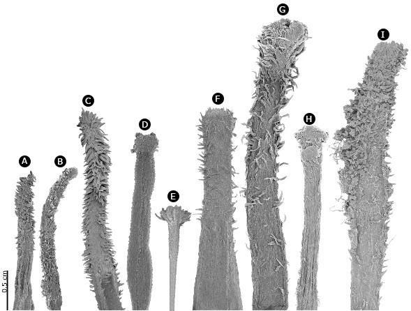
Figure 4: SEM photographs of stigmas of various Spigelia L. species, showing the trichomes along the style in some of them. A. Spigelia anthelmia L.; B. Spigelia hedyotidea A. DC.; C. Spigelia humboldtiana Cham. & Schltdl.; D. Spigelia longiflora M. Martens & Galeotti; E. Spigelia mexicana A. DC.; F. Spigelia scabrella Benth.; G. Spigelia speciosa Kunth; H. Spigelia trispicata H. Hurley ex K. Gould; I. Spigelia xochiquetzalliana S. Islas, Lozada-Pérez & L.O. Alvarado. Photographic credits: B. Mendoza-Garfias.
Pollen: the pollen grains are distributed in monads or tetrads, the shape is sub-spheroidal, occasionally oblate or prolate (Kremp, 1968), with tricolpate openings, sometimes tetracolpate, colpi occasionally with margo, exine 2-6 µm thick, with rugulated, verrucate or foveolate ornamentation (Fig. 5).

Figure 5: SEM photograph of pollen from three species of Spigelia L., A. Spigelia ayotzinapensis L.O. Alvarado, S. Islas & Bustam.; B. Spigelia guerrerensis L.O. Alvarado & J. Jiménez Ram.; C. Spigelia texana (Torr. & A. Gray) A. DC. Scale bar: 15 um. Photographic credits: B. Mendoza-Garfias.
Fruit: the fruits are bilobed globose capsules, the pericarp is thin, smooth, or papillose; the color ranges from green to brown, with loculicidal, septicidal and circumscissile dehiscence at the same time, which allows the dispersal of the seeds. The lower part of the articulation of the style remains in the fruit forming the metastyle (not shown). After dehiscence, the base of the fruit called carpoatlas remains on the peduncle (e.g., Fig. 6B; Fernández-Casas, 2003a), which consists of a hardened disk with a central perforation. In some cases, it usually shows remains of a septal membrane, that separated the two locules, as well as a transverse ridge, two projections in the middle of the carpoatlas that reflect the septicidal dehiscence of the carpels, present only in some species with difference in size. The disc can be flat or concave, and varies in shape depending on the species, ranging from oblong to elliptical or rhombic (Ash et al., 1999).

Figure 6: Morphological characters. Spigelia ambigua C. Wright: A. inflorescence; B. carpoatlas. Spigelia anthelmia L.: C. inflorescence (Naturalista, 2020b); D. carpoatlas; E. seed. Spigelia ayotzinapensis L.O. Alvarado, S. Islas & Bustam.: F. inflorescence. Photographic credits: A), B), D), E), F): S. Islas; C) Joe MDO (https://www.naturalista.mx/observations/52156993 CC BY-NC).
Seeds: the seeds range from 4 to 32 per capsule. The testa has a sulcate, reticulated, rough, scaly or foveolate ornamentation, verrucate or smooth in the depressions. The seeds mainly have a pyramidal shape, where it is easy to distinguish a highly ornamented dorsal and a ventral face where the hilum is in a depression; in some cases, they become compressed (Fernández-Casas, 2003a; Islas-Hernández et al., 2022).
Taxonomic treatment
Spigelia L., Sp. Pl. 1: 149-150. 1753.
TYPE: Spigelia anthelmia L.
≡ Anthelmenthia P. Browne, Civ. Nat. Hist. Jamaica 156. 1756, nom. superfl. = Spigelia P. Browne, Civ. Nat. Hist. Jamaica 367. 1756, non Linnaeus 1753. TYPE: not designated.
≡ Arapabaca Adanson, Fam. 2: 225, 519. VII-VIII. 1763, nom. superfl.
= Montira Aublet, Hist. Pl. Guiane 637, t. 257. 1775. TYPE: Montira guianensis Aublet.
= Heinzelmannia Neck., Elem. Bot. 1: 371. 1790, opus utique oppr.
= Canala Pohl, Pl. Bras. Icon. Descr. 2: 62, t. 142. 1830, non Canalia F. W. Schmidt 1793. TYPE: Canala heliotropoides Pohl.
= Coelostylis Torrey & A. Gray ex Endlicher & Fenzl, Nov. Stirp. Dec. 32. 1839. TYPE: Coelostylis loganioides Torrey & A. Gray ex Endlicher & Fenzl.
= Pseudospigelia W. Klett, Bot. Arch. 3: 134. 1923. TYPE: Pseudospigelia polystachya (Klotzsch) W. Klett (= Spigelia polystachya Klotsch).
Annual or perennial herbs or small shrubs; cylindrical or quadrangular stems, linear or sometimes branched; stipules deltate, lanceolate or reduced to a fringe; leaves membranous, opposite, sometimes pseudowhorled below the inflorescence, simple, sessile, or short petiolate, venation camptodromous, glabrous or pilose; inflorescences scorpioid or monochasium cymes, axillary or terminal; flowers sessile or shortly pedicellate, bracteate; calyx 5-lobed, sepals deltate, lanceolate, linear, or ovate, green, or green with purple apex or margin; corolla gamopetalous, pentamerous, hypocrateriform, tubular, campanulate or infundibuliform, tube elongated, sometimes contracted at the insertion of the filaments, 5-lobulate, petals lanceolate, ovate or deltate, exceeding the calyx, white, purple, red, green, or yellow; stamens 5, epipetalous, inserted below, above or in the middle of the corolla tube, exserted or included, filamentous, sometimes sessile o subsessile, anthers basifixed or dorsifixed, ovate-sagittate or sagittate; pollen in monads or tetrads, subspheroidal, occasionally oblate or prolate, tri- or tetracolpate; ovary superior, globose or ovoid, numerous ovules, style 1, glabrous or pubescent, articulated in the lower half, stigma 1, capitate or terete, glabrous, or pubescent; fruits capsules, globose, ovoid or bilobed, smooth, papillose, verrucous or hirsute, dehiscence septicidal, loculicidal and finally circumscissile at the base, metastyle present, sometimes deciduous, fruit base persistent in a disk called carpoatlas; seeds elliptical, semispherical, ovate, or compressed, with the testa verrucous, tuberculate, or ribbed.
Taxonomic history
The genus Spigelia was published by Linnaeus (1753) in Species Plantarum including one species (Spigelia anthelmia L.), classified within Pentandria Monogynia. Before the publication of Species Plantarum and after it was taken as a start of the botanical nomenclature, the genus had been described under different names as mentioned in the synonymy list (Stokes, 1812; Henrickson, 1996; Gould, 1997; Bernardi, 2000; Fernández-Casas, 2001).
Due to its great morphological variation in vegetative, floral and palynological characters, its position within the family has changed over the years with respect to the rest of the genera (Hutchinson, 1973; Cronquist, 1981; Thorne, 1983; Gould, 1997; Backlund et al., 2000; Fernández-Casas, 2001; Frasier, 2008; Gibbons et al., 2013; Yang et al., 2016). Martius (1826) published the monotypic family Spigeliaceae, at the same time as he described the family Loganiaceae. Meisner (1840) circumscribed Spigeliaceae within the Loganiaceae as the tribe Spigelieae, to which later A. de Candolle added the genera Mitreola L., Mitrasacme Labill., and Polypremum L., previously included in the Rubiaceae family (Gould, 1997).
Hutchinson (1973) considered that the genus Spigelia, together with the genera Mitreola and Mitrasacme, should be taken as an independent family, as Martius had previously published, which could be separated by the valvar corolla, completely united carpels, non-verticillate leaves, interpetiolar stipules, and non-winged seeds. However, this classification changed again with Leeuwenberg and Leenhouts (1980), who agreed with that established by Meisner and A. de Candolle, maintaining the tribe Spigeliae with the same genera mentioned by them. Struwe et al. (1994) carried out cladistic work based on morphology, embryology, anatomy and phytochemistry. Their results showed the tribe to be paraphyletic and as a sister to Strychneae tribe.
More recent phylogenies, based on the chloroplast markers rps16 and petD, have included several species of Spigelia, with some representatives from South America (Popovkin et al., 2011). In these works, the species are grouped as a clade within the Loganiaceae, conforming to the monogeneric tribe Spigelieae and as a sister group to the Strychneae and Loganieae tribes, the latter one including the genera Mitreola and Mitrasacme (Frasier, 2008; Popovkin et al., 2011; Yang et al., 2016). In APG IV (APG, 2016), the classification followed in the present work, the genus remains within the Loganiaceae family, in its monogeneric tribe Spigelieae with about 90 species reported for the American continent (Stevens, 2001). However, the relationships within the group have not yet been resolved, and the proposed sections have been rejected because they are based on few morphological characters (Islas-Hernández et al., 2022), some of which are associated with evolution by convergence (Gould, 1997).
The use and increase of characters, such as pollen and seeds, and the use of other evaluation tools will allow proposing more natural infrageneric classifications. Within the genus Spigelia, the use of carpological morphology has been of great help in the separation of groups that present an important correlation with floral and pollen characters, as well as with their distribution (Islas-Hernández et al., 2022).
Dichotomous key of the Spigelia species distributed in the United States of America
1a. Leaves pseudowhorled below the inflorescence …….…………………………… 2
1b. Leaves opposite below the inflorescence ………………………………… 4
2a. Leaves sessile ………………………………… Spigelia loganioides (Torr. & A. Gray ex Endl. & Fenzl) A. DC.
2b. Leaves petiolate ………………………………… 3
3a. Inflorescence terminal, scorpioid cyme; carpoatlas rhombic; seeds with rugose testa ………………………………… Spigelia anthelmia L.
3b. Inflorescence axillary, monochasium cyme; carpoatlas elliptic; seeds with foveolate testa ………………………………… Spigelia texana (Torr. & A. Gray) A. DC.
4a. Stipules deltate; metastyle shorter than the capsule ………………………………… Spigelia hedyotidea A. DC.
4b. Stipules linear; metastyle longer than the capsule ………………………………… 5
5a. Inflorescence monochasium cyme, pedicellate; sepals green; stamens included; carpoatlas rhombic ………………………………… Spigelia gentianoides Chapm. ex A. DC.
5b. Inflorescence scorpioid cyme, sessile; sepals green with purple apex; stamen exserted; carpoatlas elliptic ………………………………… Spigelia marilandica (L.) L.
Dichotomous key of the Spigelia species distributed in Mexico
1a. Flowers with corollas less than 3.5 cm long ………………………………… 2
1b. Flowers with corollas more than 4.5 cm long ………………………………… 15
2a. Stem cylindrical ………………………………… 3
2b. Stem quadrangular ………………………………… 6
3a. Stipules linear; stamens exserted from the corolla tube ………………………………… Spigelia trispicata H. Hurley ex K.R. Gould
3b. Stipules deltate; stamens included in the corolla tube ………………………………… 4
4a. Corolla hypocrateriform ………………………………… Spigelia dolichostachya Fern. Casas
4b. Corolla infundibuliform or tubular ………………………………… 5
5a. Leaves petiolate; corolla infundibuliform, 1-1.5 cm long, tube and lobes white with purple lines; capsules pubescent at the apex ………………………………… Spigelia anthelmia L.
5b. Leaves sessile; corolla tubular, 3-4 cm long, tube and lobes red; capsules completely glabrous ………………………………… Spigelia splendens Hort. Wendl. ex Hook.
6a. Leaves opposite below the inflorescence ………………………………… 7
6b. Leaves pseudowhorled below the inflorescence ………………………………… 10
7a. Inflorescences terminal ………………………………… 8
7b. Inflorescences axillary ………………………………… 9
8a. Leaves petiolate, lamina elliptic, chartaceous ………………………………… Spigelia elbakyaniae S. Islas & L.O. Alvarado
8b. Leaves sessile, lamina oblong, membranaceous ………………………………… Spigelia queretarensis Fern. Casas
9a. Corolla infundibuliform, lobes lanceolate; stamens filamentous; stigma capitate; carpoatlas oblong ………………………………… Spigelia hedyotidea A. DC.
9b. Corolla campanulate, lobes ovate; stamens sessile; stigma terete; carpoatlas quadrangular ………………………………… Spigelia polystachya Klotzsch ex Progel
10a. Corolla tube and lobes red ………………………………… Spigelia mexicana A. DC.
10b. Corolla tube and lobes white or white with purple sections ………………………………… 11
11a. Corolla campanulate ………………………………… Spigelia pygmaea D.N. Gibson
11b. Corolla infundibuliform ………………………………… 12
12a. Stem pubescent; inflorescence monochasium cyme with 1-2 flowers ………………………………… Spigelia texana (Torr. & A. Gray) A. DC.
12b. Stem glabrous or glabrescent; inflorescence scorpioid cyme with 3 or more flowers ………………………………… 13
13a. Leaves sessile; stigma capitate ………………………………… Spigelia xochiquetzalliana S. Islas, Lozada-Pérez & L.O. Alvarado
13b. Leaves petiolate; stigma terete ………………………………… 14
14a. Stem without lignification; leaves succulent; inflorescences terminal; capsules glabrous ………………………………… Spigelia carnosa Standl. & Steyerm.
14b. Stem with lignification; leaves membranaceous; inflorescences axillary; capsules pubescent ..………………………………… Spigelia coelostylioides K. Gould
15a. Inflorescence monochasium cyme ………………………………… 16
15b. Inflorescence scorpioid cyme ………………………………… 18
16a. Corolla hypocrateriform; sepals green with purple apex; stamens inserted above the middle of the tube of the corolla ………………………………… Spigelia ayotzinapensis L.O. Alvarado, S. Islas & R. Bustamante
16b. Corolla infundibuliform; sepals green; stamens inserted at the middle of the tube of the corolla …………………………………………………………………………..…… 17
17a. Corolla tube and lobes white with purple margin; capsules pubescent; carpoatlas elliptic; pollen with 4 apertures ………………………………… Spigelia guerrerensis L.O. Alvarado & J. Jiménez Ram.
17b. Corolla with tube and lobes purple; capsules glabrous; carpoatlas oblong; pollen with 3 apertures ………………………………… Spigelia scabrella Benth.
18a. Stipules deltate ………………………………… 19
18b. Stipules absent or linear ………………………………… 21
19a. Leaves pseudowhorled below the inflorescence; stamens included ………………………………… Spigelia humboldtiana Cham. & Schltdl.
19b. Leaves opposite below the inflorescence; stamens exserted ………………………………… 20
20a. Stem pubescent; leaves sessile; corolla tubular, red with yellow lobes ………………………………… Spigelia chiapensis K. Gould
20b. Stem glabrous; leaves petiolate; corolla hypocrateriform, pink with lobes pink with white margin ………………………………… Spigelia colimensis Fern. Casas
21a. Stipules absent; corolla with white tube; stamens included ………………………………… Spigelia mocinoi S. Islas & L.O. Alvarado
21b. Stipules linear; corolla with red tube; stamens exserted ………………………………… 22
22a. Corolla hypocrateriform, lobes red; stigma capitate ………………………………… Spigelia longiflora M. Martens & Galeotti
22b. Corolla infundibuliform, lobes yellow; stigma terete ………………………………… Spigelia speciosa Kunth
Dichotomous key of the Spigelia species distributed in Central America and the Caribbean
1a. Leaves pseudowhorled below the inflorescence ………………………………… 2
1b. Leaves opposite below the inflorescence ………………………………… 4
2a. Inflorescence monochasium cyme ………………………………… Spigelia sphagnicola C. Wright
2b. Inflorescence scorpioid cyme ………………………………… 3
3a. Corolla hypocrateriform; stigma capitate; metastyle smaller than the capsule; carpoatlas elliptic ………………………………… Spigelia ambigua C. Wright
3b. Corolla campanulate; stigma terete; metastyle absent; carpoatlas quadrangular ………………………………… Spigelia polystachya Klotzsch ex Progel
4a. Steam cylindrical …………………………………5
4b. Steam quadrangular ………………………………… 6
5a. Leaves petiolate; corolla infundibuliform; carpoatlas rhombic ………………………………… Spigelia anthelmia L.
5b. Leaves sessile; corolla tubular; carpoatlas elliptic ………………………………… Spigelia splendens Hort. Wendl. ex Hook.
6a. Corolla with tube and lobes completely white ………………………………… 7
6b. Corolla with tube white and lobes purple, pink or with purple lines ………………………………… 8
7a. Leaves succulent; corolla infundibuliform; stigma terete; carpoatlas elliptic ………………………………… Spigelia carnosa Standl. & Steyerm.
7b. Leaves membranaceous; corolla campanulate; stigma capitate; carpoatlas oblong ………………………………… Spigelia pygmaea D.N. Gibson
8a. Corolla more than 4 cm long; stigma capitate ………………………………… Spigelia humboldtiana Cham. & Schltdl.
8b. Corolla less than 2 cm long; stigma terete ………………………………… 9
9a. Leaves membranaceous to subcoriaceous; corolla with lobes white with purple margin, ovate; carpoatlas oblong ………………………………… Spigelia coelostylioides K. Gould
9b. Leaves chartaceous; corolla with lobes pink or purple, lanceolate; carpoatlas rhombic ………………………………… Spigelia hamelioides Kunth
Spigelia ambigua C. Wright., Anales Acad. Ci. Med. Habana 7: 102. 1870.
TYPE: CUBA. Pinar del Río, en lagunitas de poca profundidad, s.d., C. Wright 3595 (lectotype: US112904!, designated by Macedo and Buril (2021), isolectotypes: GH-72226!, NY-277648!).
= Spigelia blainii Millsp., Publ. Field Columb. Mus., Bot. Ser. 1: 432. 1900. TYPE: CUBA. Isla de Pinos, s.d., J. Blain 51 (holotype: F-0062128F!).
= Spigelia nana Alain, Mem. Soc. Cub. Hist. Nat. Felipe Poey 22: 116. 1955. TYPE: CUBA: s.l., s.d., E. P. Killip 43875 (holotype: US-00112918!).
Herbs not branched, stem quadrangular, glabrous, without lignification; leaves opposite below the inflorescence, sessile, lamina ovate, membranaceous, 2 cm long; stipules present, deltate; inflorescence terminal, scorpioid cyme, 6-7 flowers, sessile (Fig. 6A); sepals green, ovate; corolla hypocrateriform, 1.2 cm long, tube and lobes white with purple margin, lobes lanceolate; stamen insertion not seen, included, filaments not seen; pollen not observed; stigma capitate, style not seen; capsules glabrous, 3 mm diameter, metastyle present, smaller than the capsule, carpoatlas elliptic (Fig. 6B), transverse ridge absent; seeds not seen.
Distribution and habitat: endemic species of Cuba (Isla de La Juventud, Pinar del Río) (Fig. 7), where it grows in savannas on white sands of almost pure quartz (Fernández-Casas, 1998), from sea level to 50 m elevation.

Figure 7: Distribution map of Spigelia ambigua C. Wright, Spigelia anthelmia L., Spigelia ayotzinapensis L.O. Alvarado, S. Islas & Bustam., Spigelia carnosa Standl. & Steyerm., and Spigelia chiapensis K. Gould.
Conservation status: Critically Endangered (CR). The species is distributed in coastal areas in Cuba (EOO: 106.53 km2, AOO: 403.34 km2), is known from only five specimens preserved in consulted herbaria and has not been collected in the last 70 years.
Taxonomic remarks: Spigelia ambigua was originally described as S. humilis Bentham. However, this taxon was segregated into four species due to its morphological and geographical variability (Fernández-Casas, 1998), leaving S. ambigua as an endemic species of Cuba, unlike the other three taxa, all of them distributed in the Amazon region. Spigelia ambigua can be distinguished from S. humilis by being monopodial herbs (vs. shrubs), with membranous leaves (vs. fleshy leaves), and flowers in scorpioid cymes (vs. solitary flowers).
Specimens examined: CUBA. Province Isla de La Juventud, between Mina de Oro and Playa del Soldado, 6.IV.1954, E. P. Killip 43875 (US); along road to San Francisco de las Piedras, 25.XI.1955, E. P. Killip 45200 (US); Santa Fe, 25.VI.1901, A. A. Taylor 200 (US). Province Pinar del Río, Pinar del Río, C. Wright 2561 (NY), 3595 (US).
Spigelia anthelmia L., Sp. Pl. 1: 149. 1753.
TYPE: BRAZIL. Brasilia, Habitat in Cajenna, s.d., Anonyme s.n. (lectotype: LINN-HL210-2!, designated by Leeuwenberg (1961)).
= Spigelia multispica Steud., Flora 26: 764. 1843. TYPE: SURINAM. Para District, s.d., W. R. Hostmann and H. Kappler 851a (holotype: P-00507680!, isotypes: K-000573349!, MO-694152!).
= Spigelia nervosa Steud., Flora 26: 764. 1843. TYPE: SURINAM. in subhumidis umbrosis, s.d., W.R. Hostmann and H. Kappler 505 (holotype: P, isotypes: BM, K, MO).
= Spigelia anthelmia var. obliquinervia A. DC., Prodr. (A. P. de Candolle) 9: 7. 1845. TYPE: In Carabaeis, ex. gr. Jamaica: Tabago, s.d., Anonyme s.n. (holotype: G-DC00132026!).
= Spigelia anthelmia var. peruviana A. DC., Prodr. 9: 7. 1845. TYPE: PERU. s.l., s.d., H. Ruiz and J. A. Pavón s.n. (holotype: G-DC132037!).
≡ Spigelia anthelmia var. nervosa (Steud.) Progel, Fl. Bras. 6(1): 262. 1868.
= Spigelia stipularisProgel, Fl. Bras. (Martius) 6(1): 262. 1868. TYPE: COLOMBIA. s.l., s.d. J. W. K. Moritz 426 (holotype: B).
= Spigelia multispica var. discolorProgel, Fl. Bras. (Martius) 6(1): 263. 1868. TYPE: FRENCH GUIANA, s.l., VII.1824, Poiteau s.n. (holotype: P, isotype: K-000573348!).
= Spigelia killipiiEwan, Caldasia 4: 302. 1947. TYPE: COLOMBIA. Chocó, forest near junction of Río Condoto and Río San Juan, s.d., E. P. Killip 35101 (holotype: US-1771863!).
Herbs branched, stem cylindrical, glabrous, without lignification; leaves pseudowhorled below the inflorescence, petiolate, lamina ovate-lanceolate, membranaceous, 4-20 cm long; stipules present, deltate; inflorescence terminal, scorpioid cyme, 6-20 flowers, pedicellate (Fig. 6C); sepals green, lanceolate; corolla infundibuliform, 1-1.5 cm long, tube and lobes white with purple lines, lobes deltate; stamens inserted above the middle part of the corolla tube, included, filaments present; pollen in monads, suboblate, with medium polar area, 3 simple apertures, without margo on the colpi; stigma terete, style pubescent; capsules pubescent at the apex, 4.5 mm diameter, metastyle present, smaller than the capsule, carpoatlas rhombic (Fig. 6D), transverse ridge absent; seeds 16, ovate, testa rugose with triangular projections (Fig. 6E).
Distribution and habitat: species distributed in the United States of America (Florida), Mexico (Campeche, Chiapas, Guerrero, Oaxaca, Puebla, Querétaro, Quintana Roo, San Luis Potosí, Tabasco, Veracruz, and Yucatán), Belize (Belize, Cayo, and Corozal; Fernández-Casas and Huft, 2009), Guatemala, Honduras (Fernández-Casas and Huft, 2009), El Salvador (Department La Unión), Nicaragua (León, and Managua), Costa Rica (Alajuela, Limón, Puntarenas, and San José), Panama (Bocas del Toro, Chiriqí, and Panama), Bahamas (Andros Norte and Bimini), Cuba (Fernández-Casas, 2009), Jamaica (Hanover and Saint Andrew), Dominican Republic (La Altagracia), and Dominica (Saint Andrew) (Fig. 7). Outside the study area it is distributed in Venezuela, Colombia, Ecuador, French Guiana, Guyana, Suriname, Peru, Bolivia, and Brazil (Fernández-Casas and Huft, 2009). This species is also introduced in Asia (Liang et al., 2019) and Africa (Leeuwenberg, 1961). It inhabits thorn forest, mountain mesophilic forest, deciduous tropical forest, humid tropical forest, sub-deciduous tropical forest, and grasslands. It can be found from sea level to 1000 m elevation.
Conservation status: Least Concern (LC). This species is widely distributed from Florida in the United States of America to Panama (EOO: 4,806,112.601 km2, AOO: 242,500.00 km2). Populations are not affected by anthropogenic activities, nor by changes in land use, being collected in recent years even on roadsides. Due to this, the species is not considered threatened.
Taxonomic remarks: Spigelia anthelmia, together with S. humboldtiana Cham. & Schltdl., are the most widely distributed species in the American continent. It can be distinguished from the latter by its lanceolate leaves, numerous terminal inflorescences, minutely ciliate calyx lobes, and apex of the fruits papillose. Specimens of S. anthelmia have been misidentified in herbaria as S. polystachya Klotzsch ex Progel, probably because of their similarity in the lanceolate shape of the leaves. However, S. anthelmia can be distinguished by being herbs up to 1 m tall (vs. plants less than 15 cm), with flowers greater than 1 cm long (vs. flowers less than 3 mm long) and apically papillose fruits (vs. completely glabrous fruits).
Specimens examined: BAHAMAS. District Andros Norte, Nicholl’s Town, 26.V.1993, D. Goldman 424 (TEX). District Bimini, in disturbed soil near ferry landing at Yacht Club, D. S. Correll 42069 (TEX); growing among bushes and low plants in what appeared to be a dried wet spot along the road between the airport and the Federal Aviation Agency Station, 13.VII.1964, W. Stimson 716 (TEX); South Bimini Islands, weedy area along the road to the airport where it meets dirt road to Sunshine Inn and Port Royale, this spot about 1-1/3 miles southeast of the northwest tip of island, 30.III.1965, W. Stimson 1106 (TEX). BELIZE. District Belize, 42.5 mi northwest of Belize along Northern Hwy, 27.V.1973, T. B. Croat 23917 (US). District Cayo, about 1 km NE of Iguana Creek Bridge which crosses Belize River, near the town of Black Man Eddy Village, 4.VII.1995, D. E. Atha 958 (TEX); Hummingbird Highway, South of Belmopan at ca. mile 38, 21.VI.1973, J. D. Dwyer 11341 (US). District Corozal, Cerros Maya Ruins. Lowry's Bight, coastal area, 8.IV.1983, C. Crane 520 (TEX). COSTA RICA. Province Alajuela, surubres près San Mateo, P. Biolley 2663 (US). Province Limón, Grape Point (Terrón Colorado), littoral atlantique, 1.IX.1900, H. F. Pittier 14036 (US). Province Puntarenas, finca Victoria Palmar de Osa, 25.II.1972, A. Molina 27406 (US). Province San José, borde del camino, cerca del pozo San José #1, 16.III.1984, C. Cowan 4575 (TEX). DOMINICA. Parish Saint Andrew, roadside field between l'Anse Noire and Pointe Baptiste, 14.VIII.1965, W. R. Ernst 2075 (MEX). DOMINICAN REPUBLIC. Province La Altagracia, growing in open sand and grass by resort houses near the beach at the Punta Cana Beach, 21.III.2001, D. Goldman 1960 (TEX). EL SALVADOR. Department La Unión, woods North of La Union; deep shade, 16.VIII.1938, J. L. Morrison 8765 (US). GUATEMALA. Department Petén, Parque Nacional Tikal, orillando el camino para Tikal, a 55 km, 30.IX.1970, R. Tún 1055 (US). JAMAICA. Parish Hanover, hills behind Sandy Bay, 4.VIII.1963, G. R. Proctor 23894 (TEX). Parish Saint Andrew, University of West Indies Campus, 10.VI.1963, M. R. Crosby 97 (TEX). MEXICO. Campeche, municipality Calakmul, Calakmul Reserve, 28.VI.2002, P. Acevedo-Rodríguez 12227 (CICY, US); 2 km al NW de Narciso Mendoza, camino a Costa Maya, 26.VII.1997, D. Álvarez 250 (MEXU); a 10 km al S del poblado Ler de Fomento Agropecuario, camino a Dos Naciones, 14.X.1997, D. Álvarez 399 (MEXU); a 1 km al N del poblado La Lucha, 1.VII.2002, D. Álvarez 1591 (MEXU, XAL); rancho Las Delicias, a 14 km al E de Xpujil, 22.VIII.2022, D. Álvarez 1931 (MEXU); Conhuas salida a Nadzcaan, carr. Xpujil - Escárcega, 4.X.2002, D. Álvarez 2175 (MEXU); a 8.3 km al E de La Mancolona, camino a Flores Magón, 24.X.2002, D. Álvarez 2283 (MEXU); a 1.1 km al NO del poblado 16 de Septiembre, 31.VII.2003, D. Álvarez 6052 (MEXU); a 0.33 km al NE del poblado 16 de Septiembre, 30.XII.2003, D. Álvarez 7681 (MEXU); km 6 rumbo a Nuevo Becal, 12.X.1997, G. Bacab 134 (MEXU); a 3 km al NE de Pioneros del Río, 17.II.2002, J. Calónico 21531 (MEXU); 500 m al N del poblado 11 de Mayo, 14.X.1997, E. M. Lira 157 (CICY, MEXU), 117 (MEXU), 133 (MEXU); a 9 km al SE de Dos Naciones, camino a El Civalito, 23.X.1997, E. Martínez 27835 (MEXU), 29198 (MEXU); 4 km al S de la Nueva Vida, camino a Xpujil, en el puente Papagayo, 2.VIII.1997, E. Martínez 27978 (MEXU); a 1 km al N de Rancho El Sacrificio, camino a Nuevo Centro de Población Ejidal Ley de Fomento Agropecuario, 5.VIII.1997, E. Martínez 28119 (MEXU); a 13 km al S de Xcan-ha camino a Xpujil, 11.X.1997, E. Martínez 28716 (MEXU); en Puente el Papagayo, a 10 km al S de La Nueva Vida, 12.X.1997, E. Martínez 28752 (MEXU); a 10 km al SE de Ley de Fomento Agropecuario, camino a Dos Naciones, 23.X.1997, E. Martínez 29144 (MEXU); a 10 km al SE de Dos Naciones, camino el Civalito, 23.X.1997, E. Martínez 29310 (MEXU); en Puente Rancuan, a 1 km al W de Puebla de Morelia, carretera Escárcega - Chetumal, 28.X.1997, E. Martínez 29643 (MEXU, TEX); a 2 km al W de Plan de San Luis, en el km 132 de la carretera Escárcega - Chetumal, 26.XI.1997, E. Martínez 30023 (MEXU); pioneros del Río Xno-ha, 6.I.1999, E. Martínez 31791 (MEXU); Puente Castellot, 1 km al O de Castellot, 17.VIII.2002, E. Martínez 35935 (IBUG, MEXU). Municipality Campeche, 4 km al S de Cd. de Campeche, 5.IX.2002, C. Chan 7535 (MEXU); zona arqueológica Edzná, 16.VIII.1992, B. Fausty 121 (CICY); loc. cit., 29.VIII.1992, B. Fausty 201 (CICY); Tixmucuy, 4.XI.1992, B. Fausty 581 (CICY); 2 km al Noroeste de Chiná, 31.VII.1998, C. Gutiérrez 5891 (CICY, XAL); entre Xachá y Mucuychacán, al sureste de Chiná, 9.VIII.1998, C. Gutiérrez 5909 (CICY); 2 km al NE de Chiná, 22.VII.2001, C. Gutiérrez 7475 (MEXU, UAMIZ); crucero de P. Trueba y autopista, Cd. de Campeche, 10.VIII.2003, C. Gutiérrez 7865 (CICY, MEXU, UAMIZ); 4 km al S de Fco. Kobén, 22.VII.2005, C. Gutiérrez 8627 (CICY); San Antonio Ebulá, 11.IX.2002, C. Pavón 37 (MEXU); ejido López Mateos, 10.VIII.1983. A. Puch 1240 (XAL); 2 km al N de China por la carretera a Campeche, 3.IX.2001, J. L. Tapia 1216 (CICY, MEXU, XAL). Municipality Champotón, ejido López Mateos, 10.VIII.1983, E. Góngora 1044 (XAL); 3 km al S de Conhuas, 5.VII.1995, C. Gutiérrez 4468 (TEX, UAMIZ); entre Balankú y Conhuas, 3.VIII.1995, C. Gutiérrez 4591 (CICY, TEX, UAMIZ, XAL); ejido López Mateos, 10.VIII.1993, A. Puch 1240 (CICY); alrededor de la zona arqueológica de Balankú entre el km 93 y 94, 4.VII.1995, P. Zamora 4680 (CICY, TEX, XAL); entre el km 94 y 95 carretera a Xpujil, 3.VIII.1995, P. Zamora 4710 (CICY, TEX). Municipality Ciudad del Carmen, 22 km al O de Francisco Escárcega, sobre la carretera Escárcega - Chetumal, 30.VII.1987, Q. Q. Cabrera 14137 (IEB, MEXU); 4 km al N del desvío de la carretera Candelaria - Monclova, por la vía hacia el Tigre, 22.IX.1999, G. Carnevali 5845 (CICY, XAL); Punta Zacatal a Puerto Rico, 22.III.1985, C. Chan 4930 (CICY); entre el poblado Estado de México y Monclova, a la altura de la desviación a Corralitos, 7.XI.1996, E. P. Zamora 5642 (MEXU, TEX, XAL). Municipality Escárcega, 10 km antes de llegar a Escárcega, carretera Champotón, 28.VIII.1984, C. Chan 3897 (CICY). Municipality Hecelchakan, 3 km al SE de Cumpich, 21.VII.2002, Q. Q. Cabrera 49 (MEXU). Municipality Hopelchén, a 1.19 km al E de X-Mejia, 21.III.2004, D. Álvarez 8629 (MEXU); a 4.46 km al SE de Xcan-ha, 3.VIII.2004, D. Álvarez 10196 (MEXU); Jardín Botánico de Zoh-Laguna a 10 km al N de Xpujil, camino a Dzibalchén, 16.VII.1996, P. Álvaro 363 (MEXU, TEX); 3 km al S de Bolochen de Rejón, cerca de las Grutas de Xtacumbilxunan, por la carretera vía ruinas a Campeche, 25.VII.1986, E. Cabrera 11760 (MEXU, TEX); Dzibalchén y Chunchintok, 27.IX.1995, C. Gutiérrez 4905 (UAMIZ); a 8 km al E de Ucum, camino a Dzibalchén, 10.X.1997, E. Martínez 28604 (MEXU); a 1 km al N de Xcan-ha, camino a Ucum, 10.X.1997, E. Martínez 28654 (MEXU); Dos Aguadas, 16.VI.2005, E. Martínez 37808 (MEXU); a 2.4 km al E de Bel-ha, camino a la Laguna La Valeriana, 27.VIII.2005, E. Martínez 38180 (MEXU); Hopelchen, 10.VIII.1997, S. Villegas s.n. (MEXU). Municipality Tenabo, 1 km, carretera Tenabo - Kanki, 27.X.1997, P. Zamora 5804 (MEXU). Chiapas, municipality Acapetahua, Santa Teresa, 14.VII.1947, E. Matuda 16686 (MEXU). Municipality Amatenango del Valle, en el km 18 al NW del camino a Laguna Chamula, en el km 1-3 sobre el camino a Napite que sale al E de Tulanca, 24.IX.1983, O. Téllez 7225 (INEGI, MEXU). Municipality Catazajá, poblado de Catazajá, 2.XI.1998, C. Gutiérrez 6037 (XAL). Municipality Chiapa de Corzo, El Chorreadero, 16.VII.1981, D. E. Breedlove 51578 (ENCB). Municipality Chicoasén, 2 km al NW de Chicoasén, camino de Solayo a Chicoasén, 10.VIII.1998, E. Martínez 31207 (MEXU). Municipality Jiquipilas, El Ciprés - Las Campanas, 25.VII.1995, O. Farrera 733 (MEXU). Municipality Ocosingo, arroyo de Nuevo Guerrero, a 0.5 km del poblado hacia el S, 28.VI.2002, G. Aguilar 1610 (MEXU); crucero Bethel, 20.X.2002, G. Aguilar 3958 (MEXU); a 3 km del crucero Lacanjá Tsenzal rumbo al poblado, 18.I.2003, G. Aguilar 5044 (MEXU); a 2 km al W de Crucero Corozal, camino a Palenque Boca Lacantum, 2.XII.1984, E. Martínez 8889 (MEXU); Boca Lacantum sobre río Lacantum, 10.XII.1984, E. Martínez 9585 (MEXU); a 2 km al W de Crucero Corozal, camino a Palenque Boca Lacantum, 13.II.1985, E. Martínez 10265 (MEXU). Municipality Palenque, 3-5 km al N de Palenque a lo largo del camino a Catazaja y Villa Hermosa, 28.VII.1972, D. E. Breedlove 26651 (MEXU); 10 km al N de la carretera Palenque - Escárcega, sobre el camino a Palizada, 6.III.1982, E. Cabrera 1975 (MEXU); 8 km al NE de Palenque, sobre el camino a La Libertad y Emiliano Zapata, 20.XI.1986, E. Cabrera 12404 (MEXU); rancho La Estrella, adelante de Pénjamo en terracería hacia Ocosingo y Bonampak, 14.X.1980, C. Cowan 3282 (CICY, MEXU); km 125 carretera Villahermosa - E. Zapata, cerca de Palenque, 22.IX.1971, R. Hernández 1244 (ENCB, MEXU). Municipality Salto de Agua, W de Catazaja en el camino a Villahermosa, 10.XI.1981, D. E. Breedlove 55259 (ENCB). Municipality Tuxtla Gutiérrez, el Zapotal, al SE de Tuxtla Gutiérrez, 15.X.1988, E. Palacios 878 (FCME). Municipality Villa Comaltitlan, carretera Villahermosa - E. Zapata, km 125-127, 22.IX.1971, R. Hernández 1244 (MEXU). Guerrero, municipality Chilpancingo de los Bravo, Cerro del Alquitrán, adelante de Petaquillas, al SE de Chilpancingo de los Bravos, 22.X.1978, W. Schwabe s.n. (MEXU). Oaxaca, municipality Asunción Ixtaltepec, sabanas y matorrales espinosos, al sureste de Nizanda, 28.IX.1999, L. I. López 51 (MEXU); 1.66 km al NW del Morrito, cima cerro Timbón, 13.I.2002, S. H. Salas 4656 (MEXU, SERO). Municipality San Juan Bautista Tuxtepec, Chiltepec, 6.II.1981, L. M. García R. 36T (OAX); Chiltepec and vicinity, 1.VII.1940, G. Martínez 259 (US); 1.66 km al NW del Morrito, cima cerro Timbón, 17.IV.1967, G. Martínez 1364 (FCME, MEXU, OAX, TEX, XAL). Puebla, municipality Hueytamalco, el cerro, 22.X.1980, F. Ventura 17871 (OAX). Querétaro, municipality Jalpan de Serra, Tanchanaquito, 4.X.19881 B. Servín 1369 (IEB, QMEX). Quintana Roo, municipality Bacalar, Bacalar, 28.VII.1974, L. Wolfgang 3207 (MEXU). Municipality Benito Juárez, brecha camino del norte, sobre carretera Cancún - Mérida, 6.XI.1980, E. Cabrera 79 (CICY, MEXU). Municipality Felipe Carrillo Puerto, brecha camino del norte, sobre carretera Cancún - Mérida, 15.XII.1983, E. Cabrera 6293 (MEXU); km 4 Vigía Chico - F. Carrillo Puerto, 31. X.1985, I. Olmsted 57 (MEXU); a 1 km al E de F. Carrillo Puerto, sobre camino a Vigía Chico, 10.VI.1980, O. Téllez 2815 (MEXU). Municipality José María Morelos, a 0.7 km al O del poblado Plan de la Noria a orilla de la laguna, 16.III.2004, D. Álvarez 8249 (MEXU); a 2.78 km al N del poblado Zafarrancho, 19.III.2004, D. Álvarez 8469 (MEXU); a 0.7 km al N del poblado Sabana San Francisco, 19.VI.2004, D. Álvarez 9417 (MEXU); a 1 km al E de F. Carrillo Puerto, sobre camino a Vigía Chico, 10.VI.1982, D. Álvarez 10517 (MEXU); a 3.66 km al SE de Sabana San Francisco, 3.IX.2004, D. Álvarez 10518 (MEXU); a 5.5 km al SSE del poblado Pozo Pirata, 9.IX.2002, D. Álvarez 10621 (MEXU); a 18.2 km al NO de Ukum, 31.V.2005, D. Álvarez 10971 (MEXU); a 3 km al O de Othón P. Blanco, 15.VI.2005, D. Álvarez 11176 (MEXU); a 7.2 km al N de Othón P. Blanco camino a Tigre Grande, 17.VIII.2005, D. Álvarez 11533 (MEXU); a 0.6 km al OSO de La Pimienta camino a Gavilanes, 14.VI.2005, E. Martínez 37726 (MEXU); a 0.73 km al N de Zafarrancho, 22.VIII.2005, E. Martínez 38130 (MEXU). Municipality Lázaro Cárdenas, ejido Kantunilkín, área de reserva del CBTA 186, 14.XI.2002, A. M. Chan 137 (CICY, XAL). Municipality Othón P. Blanco, 20 km al N de la Unión, 22.III.1982, E. Cabrera 2134 (CICY, MEXU); 3-4 km al Oeste de Margarita Maza, unos 11 km al O de Graciano Sanchez (La Pantera), 25.VIII.1999, G. Carnevali 5591 (CICY, XAL); camino Tomás Garrido a Dos Aguadas, 22.XI.1984, C. Chan 4345 (CICY, MEXU); zoológico y Jardín Botánico Payo Obispo, 30.VIII.1989, P. Herrera 20 (MEXU); entre fundo legal Bacalar Límite Sur, 4.VII.1981, M. Narváez 432 (CICY, XAL); a 12 km al S del Ingenio A. Obregón, 11.IV.1980, O. Téllez 1983 (MEXU); en la entrada del camino a Nuevo Becan, a 1 km del límite de Campeche, 13.X.1980, O. Téllez 3594 (MEXU); Cd. de Chetumal, en el zoológico Payo Obispo, Av. Insurgentes con Andrés Quintana Roo, 5.VI.1990, S. Torres 233 (CICY); a 1 km de Limones rumbo a Carrillo Puerto, 9.VIII.1981, E. Ucan 1341 (CICY, XAL). San Luis Potosí, municipality Cárdenas, Poza Azul, cerca de Canoas, 15.IX.1967, J. Rzedowski 24562 (ENCB). Municipality Ciudad del Maíz, El Salto, 31.VII.1960, L. González s.n. (ENCB). Municipality Tamasopo, San Nicolás de los Montes, 28.V.1959, J. Rzedowski 10667 (ENCB). Municipality Tamazunchale, alrededores de Tamán, 28.VI.1959, J. Rzedowski 11011 (ENCB). Municipality Xilitla, 3 km al N de El Lobo, 6.V.1959, J. Rzedowski 10600 (ENCB). Tabasco, municipality Carmen, aproximadamente 17 km al NE de Cd. del Carmen, sobre carretera a Champotón, en la Isla del Carmen, 29.XI.1987, E. Cabrera 15085 (MEXU). Municipality Centro, Villahermosa - Teapa (km 25), 29.III.1973, R. Hernández 1869 (MEXU). Municipality Paraíso, 1 km al NO del Paraíso, sobre el camino a Barra de Topilco, 21.XI.1987, E. Cabrera 14732 (IEB, MEXU). Municipality Teapa, Cerro del Madrigal, cerca de las Grutas, 19.V.1987, H. Cáliz de Dios 9648 (OAX); Teapa, a lo largo del camino entre Teapa y Tacotalpa, 3.1 mi al E de Teapa, ca ¼ mi al S de la autopista, 19.II.1987, T. B. Croat 65337 (MEXU); 0.34 km al E de Chapingo, Universidad Autónoma de Chapingo, 28.I.2002, J. Calónico 21155 (MEXU). Municipality Villahermosa, Tenosique, 2.IX.1986, J. L. Domínguez 236 (XAL); Finca Campo Dorado, 18.VII.1986, R. Guerrero 233 (XAL); centro procesador de Gas Nuevo Pemex, a 5 km al NNE de Reforma, 30.X.1998, A. M. Hanan 1122 (MEXU); ejido Faustino, 27.XII.1996, A. Ramírez 26 (MEXU). Veracruz, municipality Actopan, Pajaritos, 1 km al NE, 18.IX.1998, G. Castillo 18371 (MEXU, XAL). Municipality Alto Lucero, Boquilla, carretera Cardel a Nautla, 2.X.1982, F. Vázquez 698 (XAL). Municipality Catemaco, Monte Pío, 15 km al W de Catemaco, 10.VIII.1964, L. González 1502 (ENCB); Sontecomapan, cerca de Catemaco, 27.III.1956, L. Paray 1937 (ENCB); Arroyo Agrio, 28.V.1969, R. C. Trigos 85 (HUAP). Municipality Dos Ríos, Palo Gacho, 18.VIII.1973, F. Ventura 11801 (IEB, MEXU, XAL); El Aguaje, 8.IX.1975, F. Ventura 8872 (IEB, MEXU, XAL). Municipality Jalcomulco, mesa del barro negro, entre Jacomulco y Tlacotalpan, 26.IX.1984, G. Castillo 3314 (XAL); Cerro del Brujo, 3 km al N de Jacomulco, 12.XII.1991, G. Castillo 8551 (XAL). Municipality Poteapan, San Fernando, 24.IX.1986, M. C. González 176 (XAL). Municipality San Andrés Tuxtla, alrededores de Montepío, 27.III.1964, L. González s.n. (ENCB). Municipality Sontecomapan, Estación Biológica UNAM, 27.II.1969, R. Cedillo 64 (HUAP). Municipality Tlacotalpan, 2 km al SE de Zunupatastla, 5.III.1981, T. P. Ramamoorthy 1746 (INEGI, MEXU). Yucatán, municipality Chankom, camino a Xcopteil, 14.VIII.1984, C. Chan 3841 (CICY). Municipality Chemax, a 12 km al O de Chemax, sobre la carretera Valladolid - Cancún, 16.VII.1985, E. Cabrera 8887 (MEXU). Municipality Chikindzonot, Xcocmil camino a Pop, 26.VII.1983, C. Chan 3472 (CICY, MEXU). Municipality Maxcanú, Chunchucmil hacia el crucero, 5.VIII.1986, C. Chan 6961 (CICY, MEXU, UAMIZ). Municipality Mérida, parque # 3 del Frac. Francisco de Montejo, calle 47 x 50, 15.IX.1998, M. Juan-Qui 1 (CICY, MEXU). Municipality Muna, a 5 km al S de Muna, sobre carretera vía Ruinas a Campeche, 25.VI.1986, E. Cabrera 11705 (MEXU, TEX); km 10 carretera Muna a Opichén, 24.IX.1984, C. Chan 3994 (CICY, MEXU). Municipality Oxkutzcab, alrededores de la zona arqueológica de la Reserva Biocultural Kiuic, a 20 km al SW del pueblo de Xul, 31.X.2005, G. Carnevali 7115 (CICY, MEXU); Xul, 5.IX.1983, F. May 136 (CICY, XAL); Xul - camino antiguo a Tekax 2 km, 10.VIII.1983, O. L. Sanabria s.n. (CICY, XAL). Municipality Tekax, a 0.2 km al SSE de Dos Aguadas, 18.VI.2004, D. Álvarez 9396 (MEXU). Municipality Tizimín, 5 km al NW de la ciudad de Tizimín (por el libramiento), 4.VIII.2005, J. L Tapia M 1653 (CICY, MEXU, TEX, XAL). Municipality Valladolid, sobre el camino a Yalcon, a 4 km al S de Valladolid, 24.IX.1985, E. Cabrera 9314 (MEXU); 2 km al O de Ticuch, sobre la carretera 180, tramo Cancún - Valladolid, 21.VII.1986, E. Cabrera 11524 (MEXU); a 12 km al O de Chemax, sobre la carretera Valladolid - Cancún, 16.VII.1985, E. Cabrera 88887 (CICY); Xuilub, 7.IX.1989, G. Campos-Ríos 1084 (CICY); ejido de Pixoy, 26.VIII.1980, C. Vargas 127 (CICY). Municipality Yaxcabá, en una milpa, 10.VII.1984. J. S. Flores 10231 (CICY). NICARAGUA. Department León, El Velero, at mouth of Estero San José, ca. 10 km by road S of hwy. 32, 9.IX.1984, W. D. Stevens 23090 (TEX, US). Department Managua, Managua, 12.IX.1923, D. Chaves 12 (US). PANAMA. Province Bocas del Toro, NE side of the island, 30.VI.1989, P. M. Peterson 6431 (US). Province Chiriqí, David airport, disturbed grassland and edge of marsh, 14.XII.1966, W. H. Lewis 736 (US). Province Panama, canal zone, Madden Dam, Boy Scout Camp road, roadside woods, 2.VIII.1967, J. D. Dwyer 7519 (US); San José Island, Pearl Archipiélago rocky coastal at East Harbor, 13.VII.1945, C. O. Erlanson 453 (US); Pedro Miguel, C.Z., 6.IV.1921, B. Heriberto 90 (US); Ancon, in streets, 8.VI.1918, E. P. Killip 3328 (US); Ancon Hill, 17.X.1922, E. P. Killip 12109 (US); Taboga Island, Gulf of Panama, 20.V.1911, H. Pittier 3624 (US); laguna de Juan Corso, near Chepo, 1.X.1911, H. Pittier 4669 (US); Balboa, Canal zone, 1.XI.1923, P. C. Standley 25495 (US), 30899 (US); vicinity of Juan Franco Race Track, near Panama, 21.XII.1923, P. C. Standley 27745 (US); vicinity of Miraflores Locks, at the Corrosion Laboratory, 1.VI.1959, W. L. Stern 70 (US). UNITED STATES OF AMERICA. Florida, county Monroe, Key Largo, towards the north end of Key Monroe, 25.X.1973, D. S. Correll 40299 (TEX).
Spigelia ayotzinapensis L.O. Alvarado, S. Islas & Bustam., Phytotaxa 331(2): 244. 2017.
TYPE: MEXICO. Guerrero, Chilapa de Álvarez, Parque Nacional General Juan N. Álvarez, 31.VI.2010, R. Bustamante et al. 414 (holotype: FCME-162178!).
Herbs not branched, stem quadrangular, pubescent, without lignification; leaves opposite below the inflorescence, sessile, lamina ovate-lanceolate, chartaceous, 2.9-3.2 cm long; stipules absent; inflorescence terminal, monochasium, 1-2 flowers, pedicellate (Fig. 6F); sepals green with purple apex, linear; corolla hypocrateriform, 8-10 cm long, tube white with purple lines, lobes white with purple margin, lobes elliptic; stamens inserted above the middle part of the corolla tube, included, filaments present; pollen in tetrads, oblate-spheroidal, with large polar area, 4 simple apertures, without margo on the colpi; stigma capitate, style pubescent; capsules not seen; seeds not seen.
Distribution and habitat: endemic species of Mexico (Guerrero) (Fig. 7), which is restricted to Quercus forest; it has been recorded at 2078 m elevation.
Conservation status: Critically Endangered (CR). Spigelia ayotzinapensis is known only from the type locality. Although the population seems abundant and the area surrounding the municipality is still conserved, the specimen was collected eleven years ago, and the locality is currently severely affected by livestock. We suggest assigning the category of Critically Endangered due to the very restricted area of distribution and the anthropogenic impact to the type locality (Islas-Hernández et al., 2017b).
Taxonomic remarks: this species is similar to Spigelia mocinoi S. Islas and L.O. Alvarado, due to its sessile, ovate-lanceolate leaves without stipules, both endemic to Mexico. They can be easily distinguished by quadrangular stems (vs. cylindrical), chartaceous leaves (vs. membranaceous), monochasium with 1-2 flowers (vs. scorpioid top with 3-5 flowers), green sepals with purple apex (vs. green) and white corolla with purple apex (vs. white corolla). Spigelia mocinoi is restricted to Mexico State, while S. ayotzinapensis is endemic to the state of Guerrero.
Spigelia carnosa Standl. & Steyerm., Publ. Field Mus. Nat. Hist., Bot. Ser. 23: 72. 1944.
TYPE: GUATEMALA. Huehuetenango, dense rich wet woods between Yulhuitz and Maxbal, Sierra de los Cuchumatanes, 15.VI.1942, J. A. Steyermark 48692 (holotype: F-0062160!, isotypes: GH-00107105!, US-00112909!).
Herbs not branched, stem quadrangular, glabrous, with lignification; leaves pseudowhorled below the inflorescence, petiolate, lamina elliptic-lanceolate, succulent, 6-13 cm long; stipules present, deltate; inflorescence terminal, scorpioid cyme, 12-30 flowers, pedicellate (Fig. 8A); sepals green, linear; corolla infundibuliform, 1.9-2.4 cm long, tube and lobes white, lobes ovate; stamens inserted below the middle part of the corolla tube, included, filaments present; pollen in monads, oblate, with small polar area, 3 simple apertures, without margo in the colpi; stigma terete, style pubescent; capsule glabrous, 7-8 cm diameter, metastyle present, smaller than the capsule, carpoatlas elliptic (Fig. 8B), transverse ridge absent; seeds elliptic, testa granulate (Fig. 8C).

Figure 8: Morphological characters. Spigelia carnosa Standl. & Steyerm.: A. inflorescence; B. carpoatlas; C. seed. Spigelia chiapensis K. Gould: D. inflorescence. Spigelia coelostylioides K. Gould: E. inflorescence (Naturalista, 2014); F. carpoatlas; G. seed. Photographic credits: A), B), C), D), F), G): S. Islas; E) F. Manuel (https://www.naturalista.mx/photos/33303999 CC BY-NC).
Distribution and habitat: species distributed in Mexico (Chiapas), Guatemala (Alta Verapaz and Baja Verapaz), and El Salvador (Fernández-Casas and Huft, 2009) (Fig. 7). It inhabits mountain mesophilic forest and semi-deciduous tropical forest at 1300-2500 m elevation.
Conservation status: Vulnerable (VU). Spigelia carnosa is known from less than ten populations in Mexico and Guatemala and has not been collected in the last 30 years. In addition to this, populations are threatened by anthropogenic activities that can reduce the number of individuals. Based on the results of the occupied area (EOO: 19,506.56 km2, AOO: 10,846.11 km2), the extension of the species is very restricted.
Taxonomic remarks: this species is similar to S. humboldtiana when dry. It differs in the number of flowers, which is higher in S. carnosa. In addition to this, S. carnosa is characterized by the thicker leaves (vs. membranous), stalked inflorescences (vs. sessile), and larger seeds.
Specimens examined: GUATEMALA. Department Alta Verapaz, Río Tzimajil, near Cobán, 29.III.1941, P. C. Standley 90272 (US). Department Baja Verapaz, Union Barrios, on hilltop, in high forest, east of km 154, 7.VI.1975, C. L. Lundell 19390 (TEX); Niño Perdido, en Quebrada Seca, high forest, 6 km N, 31.V.1977, C. L. Lundell 21031 (TEX). MEXICO. Chiapas, municipality La Independencia, third ridge along road from Las Margaritas to Campo Alegre, 18.II.1973, D. E. Breedlove 336464 (MEXU). Municipality La Trinitaria, 4 km al E de Laguna Tsiskaw cerca de Dos Lagos, 19.X.1974, D. E. Breedlove 29632 (MEXU, TEX); a 1 km E de la Laguna Tsiskaw, Parque Nacional Monte Bello, 16.XI.1972, D. E. Breedlove 38815 (MEXU). Municipality Las Margaritas, camino de terracería entre La Soledad y Tierra Fría, 6.XI.1984, A. Méndez 7960 (MEXU). Municipality Ocozocoautla de Espinosa, Cerro la Colmena, NE del Rancho Corociño, Reserva Ecológica El Ocote, 27.IV.1983, J. I. Calzada 9638 (MEXU, XAL).
Spigelia chiapensis K. Gould, Brittonia 51(4): 410-411. 1999.
TYPE: MEXICO. Chiapas, Amatenango del Valle, Amawitz, 4 km al O de la cabecera municipal, 12.VI.1988, M. Gómez López 521 (holotype: MEXU-574652!, isotypes: CAS, TEX-00256905!).
Herbs not branched, stem quadrangular, pubescent, without lignification; leaves opposite below the inflorescence, sessile, lamina ovate-elliptic, membranaceous, 2-10 cm long; stipules present, deltate; inflorescence terminal, scorpioid cyme, 7-16 flowers, sessile (Fig. 8D); sepals green with purple apex, linear; corolla tubular, 6-7.5 cm long, tube red, lobes yellow, lobes lanceolate; stamens inserted above the middle part of the corolla tube, exserted, filaments present; pollen oblate-spheroidal, with large polar area, 3 simple apertures, without margo on the colpi; stigma terete, style pubescent; capsule not seen; seeds not seen.
Distribution and habitat: endemic species of Mexico (Chiapas) (Fig. 7). It inhabits coniferous forest and grasslands; it has been collected at 1800 m elevation.
Conservation status: Critically Endangered (CR). This species is known from three localities and has not been collected in the last 30 years. It has a restricted distribution, being an endemic species of the state of Chiapas. The analysis carried out from the known distribution yields a value that is less than 0.1% of the country's area (EOO: 20.94 km2, AOO: 7.09 km2). Considering the restricted area and the absence of new collections of this species, the category of CR is suggested.
Taxonomic remarks: this species is similar to Spigelia speciosa Kunth in the red corolla tube and lighter colored lobes, the base of the persistent style. However, S. chiapensis can be differentiated by shorter sepals, smaller corollas with yellow lobes, no throat constrictions, and longer anthers.
Specimens examined: MEXICO. Chiapas, municipality Amatenango del Valle, Amawitz, 4 km al O de la cabecera municipal, 12.VI.1988, M. Gómez 521 (IMSS); loc. cit., 21.VI.1945, E. Matuda 5886 (TEX). Municipality Teopisca, NW de Teopisca por la Autopista 190, 15.VI.1965, D. E. Breedlove 10520 (ENCB, TEX); pine-oak forest along route 190, about 10 miles east of Teopisca, 24.VI.1960, R. Merrill 3009 (TEX).
Spigelia coelostylioides K. Gould, Brittonia 51(4): 407. 1999.
TYPE: MEXICO. Chiapas, Venustiano Carranza, Aguacatenango, 19.V.1995, K. Gould 139 (holotype: TEX-256906!, isotypes: G, MEXU-854904!, NY).
Herbs branched, stem quadrangular, glabrescent, with lignification; leaves pseudowhorled below the inflorescence, petiolate, lamina ovate-elliptic, membranaceous to subcoriaceous, 1.1-3.5 cm long; stipules present, deltate; inflorescence axillary, scorpioid cyme, 3-12 flowers, pedicellate (Fig. 8E); sepals green, triangular; corolla infundibuliform, 0.6-1.5 cm long, tube white, lobes white with purple margin, lobes ovate; stamens inserted at the middle part of the corolla tube, included, filament present; pollen oblate-spheroidal, with medium polar area, 3 simple apertures, without margo on the colpi; stigma terete, style pubescent; capsule pubescent, 7-8 mm diameter, metastyle present, smaller than the capsule, carpoatlas oblong (Fig. 8F), transverse ridge absent; seeds ovate, testa rugose (Fig. 8G).
Distribution and habitat: species distributed in Mexico (Chiapas, Oaxaca, Puebla, and Veracruz) and Guatemala (Gould, 1999) (Fig. 9). It inhabits tropical deciduous forest, humid tropical forest, and sub-deciduous tropical forest; it has been recorded from 200 to 1500 m elevation.

Figure 9: Distribution map of Spigelia coelostylioides K. Gould, Spigelia colimensis Fern. Casas, Spigelia dolichostachya Fern. Casas, Spigelia elbakyaniae S. Islas & L.O. Alvarado, and Spigelia gentianoides Chapm. ex A. DC.
Conservation status: Least Concern (LC). This species has a broad distribution, extending from central Mexico to Guatemala (EOO: 106,135.14 km2, AOO: 32,500.00 km2). Likewise, it has been collected in different locations in recent years. Therefore, it is not considered under any category of threat.
Taxonomic remarks: this species is similar to S. hedyotidea A. DC. in herbaceous habit, leaf size, and flower appearance (Gould, 1999). However, S. coelostylioides differs from this by being monopod plants (vs. branched plants), with whorled leaves (vs. all-opposite leaves), sessile inflorescences (vs. pedunculate inflorescences), and papillose capsules (vs. smooth capsules). Likewise, S. coelostylioides is restricted to southern Mexico and northern Guatemala, while S. hedyotidea is distributed in northern Mexico and the United States of America.
Specimens examined: MEXICO. Chiapas, municipality Altamirano, El Tiamanil, Lado Norte del poblado ejido Puebla Nueva, 18.IX.1987, A. Pérez 1 (MEXU). Municipality Comitán de Domínguez, camino a Zaragoza de la Montaña, 24.VI.1994, A. Chamé 29 (MEXU); Comitán, 3.IV.1904, E. A. Goldman 822 (US); Trapichito - Comitán, 2.VI.1945, E. Matuda 5760 (MEXU); 18 km al WNW de Comitán, sobre la carretera a San Cristóbal de las Casas, 2.X.1975, J. Rzedowski 33627 (ENCB). Municipality La Independencia, 6-10 km al NNE de la Soledad por el camino de las Margaritas a Campo Alegre, 26.XI.1980, D. E. Breedlove 47799 (ENCB). Municipality Las Margaritas, dirt road from Las Margaritas to La Soledad, ca 8.5 mi from end of paved rd. at the edge of Las Margaritas to rocky, grassy slope, 21.V.1995, K. Gould 140 (TEX). Municipality Ocosingo, en campamento COFOLOSA a 24 km al SE de crucero Corozal, camino a Boca Lacantum, 25.II.1985, E. Martínez 11306 (MEXU). Municipality Oxchuc, paraje Rancho del Cura, 7.VI.1984, S. Luna 33 (IMSS). Municipality Trapichito, Trapichito, near Comitán, 2.VI.1945, E. Matuda 5760 (TEX). Municipality Venustiano Carranza, Venustiano Carranza, 25.V.1965, D. E. Breedlove 10022 (US). Oaxaca, municipality San Lucas Ojitlán, poblado de Vistahermosa, 21.I.1989, J. I. Calzada 14187 (MEXU). Municipality Tuxtepec, Chiltepec and vicinity, 1.VII.1940, A. Arboretum 429 (US). Puebla, municipality Hueytamalco, campo experimental Las Margaritas, INIFAP, 26.IV.2008, G. Cornejo 2781 (IEB, MEXU). Veracruz, municipality Emiliano Zapata, barranca de San Antonio; 1 km al NW de Corral Falso, 8.IV.1976, W. Márquez 876 (XAL). Municipality Huatusco, Río Surco, 1 km al SO de la carretera Huatusco - Coscomatepec, 30.VIII.1979, S. Avendaño 493 (XAL), km 2 camino de terraceria Huatusco - Elotepec, 24.IV.1980, S. Avendaño 786 (XAL). Municipality Teocelo, Teocelo, 20.IV.1982, A. Cruz 409 (XAL). Municipality Uxpanapa, a 3.3 km al SO del Poblado 11, 7.VIII.2007, E. Martínez 39501 (MEXU). Municipality Veracruz, en el km 30-40 carretera Huatusco - Fortin, 1.III.1975, V. Sosa 67 (IEB, XAL).
Spigelia colimensis Fern. Casas, Fontqueria 55(65): 521. 2008.
TYPE: MEXICO. Colima, Tecolapa, Cerro San Miguel, 21.VIII.1987, F. Leger CUIDA-841 (holotype: IBUG-88634!, isotype: IBUG-89167!).
Herbs not branched, stem quadrangular, glabrous, without lignification; leaves opposite below the inflorescence, petiolate, lamina ovate-elliptic, membranaceous, 6-11.8 cm long; stipules present, deltate; inflorescence terminal, scorpioid cyme, 5-14 flowers, pedicellate (Fig. 10A); sepals green, lanceolate; corolla hypocrateriform, 2-4.5 cm long, tube pink, lobes pink with white margin, lobes deltate; stamens inserted above the middle part of the corolla, exserted, filaments present; pollen not seen; stigma capitate, style glabrous; capsule not seen; seeds not seen.
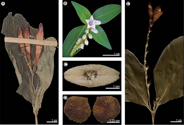
Figure 10: Morphological characters. Spigelia colimensis Fern. Casas: A. inflorescence. Spigelia dolichostachya Fern. Casas: B. inflorescence (Naturalista, 2016); C. carpoatlas; D. seed. Spigelia elbakyaniae S. Islas & L.O. Alvarado: E. inflorescence. Photographic credits: A), C), D), E): S. Islas; B: E. Jiménez (https://www.naturalista.mx/observations/4215055 CC BY-NC).
Distribution and habitat: endemic species of Mexico (Colima) (Fig. 9), where it lives in sub-deciduous tropical forest at 500 m elevation.
Conservation status: Critically Endangered (CR). This species is known only from the type specimen and has not been collected again since nearly 30 years.
Taxonomic remarks: Spigelia colimensis shows characteristics similar to S. longiflora M. Martens and Galeotti, due to the branching stems, membranous leaves and red hypocrateriform flowers. It can be distinguished from the latter by having petiolate leaves (vs. sessile leaves), smaller corollas (vs. longer corollas), and internally white corolla lobes (vs. red lobes).
Spigelia dolichostachya Fern. Casas, Fontqueria 55(23): 129. 2004.
TYPE: MEXICO. Chiapas, Ocosingo, Naja, 2 km al N camino de Chancalá, 17.VI.1986, E. M. Martínez and M. A. Soto 18778 (holotype: MEXU-580222!, isotype: IEB-084136!).
Herbs not branched, stem cylindrical, glabrous, without lignification; leaves pseudoworled below the inflorescence, petiolate, lamina lanceolate, chartaceous, 7 cm long; stipules present, deltate; inflorescence terminal, scorpioid cyme, more than 30 flowers, pedicellate (Fig. 10B); sepals green, lanceolate; corolla hypocrateriform, 1.5-1.7 cm long, tube and lobes white, lobes deltate; stamens inserted above the middle part of the corolla tube, included, filaments present; pollen oblate-spheroidal, with medium polar area, 3 simple apertures, without margo on the colpi; stigma terete, style glabrous; capsule pubescent, 4.5 mm diameter, metastyle present, smaller than the capsule, carpoatlas elliptic (Fig. 10C), transversal ridge present; seeds discoid, testa reticulate (Fig. 10D).
Distribution and habitat: endemic to Mexico (Chiapas) (Fig. 9). It inhabits mountain mesophilic forest at 900 m elevation.
Conservation status: Critically Endangered (CR). This species is known only from one population in the state of Chiapas, in an area with a high anthropogenic impact. In addition, more than 30 years have passed since it has been collected for the last time.
Taxonomic remarks: Spigelia dolichostachya is similar to S. anthelmia in the pseudowhorled leaves below the inflorescence, terminal inflorescences, and papillose capsules at the apex. It can be easily distinguished from it by the monopodial stems (vs. branching stems), chartaceous leaves (vs. membranous leaves), and very long inflorescences with more than 30 flowers on very short peduncles (vs. short inflorescences with less than 20 flowers).
Spigelia elbakyaniae S. Islas & L.O. Alvarado, Phytotaxa 477(2): 278. 2020.
TYPE: MEXICO. Oaxaca, Juchitán, municipio Santa María Chimalapa, camino hacia arroyo San Vicente, 11 km LR SE de la Gringa, 23.III.1995, E. Torres 540 (holotype: SERO!, isotype: OAX!).
Herbs not branched, stem quadrangular, pubescent, without lignification; leaves opposite below the inflorescence, petiolate, lamina elliptic, chartaceous, 5.7-6.8 cm long; stipules present, deltate; inflorescence terminal, scorpioid cyme, up to 10 flowers, sessile (Fig. 10E); sepals green, linear; corolla infundibuliform, 1.3-1.6 cm long, tube and lobes white with purple lines, lobes ovate; stamens inserted below the middle part of the corolla tube, included, filaments present; pollen not seen; stigma terete, style glabrous; capsule not seen; seeds not seen.
Distribution and habitat: endemic to Mexico (Oaxaca) (Fig. 9). It inhabits mountain mesophilic forest, and has been recorded at 900 m elevation.
Conservation status: Critically Endangered (CR). Spigelia elbakyaniae is known from the type locality only. The specimen was collected over 25 years ago in the state of Oaxaca, Mexico. Additionally, the forests where the species was collected is under deforestation due to timber harvesting and farming; it has been subject to social and environmental problems such as the fires of 1988 (Trejo, 2006).
Taxonomic remarks: the species is morphologically similar to S. humboldtiana and S. anthelmia in floral characters. However, it can be distinguished from these by the opposite leaves below the inflorescence, chartaceous leaf texture, pedunculated inflorescences, and style less than 1 cm long. The style size, less than half of the corolla tube, has not been reported in any other species of the genus in the NA region.
Spigelia gentianoides Chapm. ex A. DC., Prodr. 9: 5. 1845.
TYPE: UNITED STATES OF AMERICA. Florida, without specific locality or date, A. C. Chapman s.n. (lectotype: G-00368318!, lectotype designated by K. Gould (1996, p. 418), isolectotype: G-00368317!).
Herbs not branched, stem cylindrical, glabrous, without lignification; leaves opposite below the inflorescence, sessile, lamina ovate-lanceolate, coriaceous, 2-4 cm long; stipules present, linear; inflorescence terminal, monochasium cyme, 1-2 flowers, pedicellate (Fig. 11A); sepals green, lanceolate; corolla infundibuliform, 6-8 cm long, tube pink, lobes pink with purple lines, lobes lanceolate; stamen insertion not seen, included, filaments present; pollen not seen; stigma terete, style not seen; capsule glabrous, 9-9.5 mm diameter, metastyle present, longer than the capsule, carpoatlas rhombic, transversal ridge absent; seeds not seen.
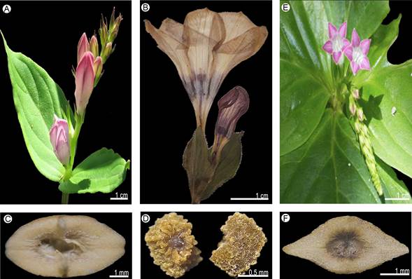
Figure 11: Morphological characters. Spigelia gentianoides Chapm. ex A. DC.: A. inflorescence (Naturalista, 2021). Spigelia guerrerensis L.O. Alvarado & J. Jiménez Ram.: B. inflorescence; C. carpoatlas; D. seed, R. Cruz-Durán 197 (FCME, MEXU). Spigelia hamelioides Kunth: E. inflorescence (Naturalista, 2020c); F. carpoatlas. Photographic credits: A) J. Appleget (https://www.naturalista.mx/observations/76105017 CC BY-NC); B), C), D), F): S. Islas; E) H. Szczygiel (https://www.naturalista.mx/observations/48085957 © reproducida con autorización del autor).
Distribution and habitat: endemic species of the United States of America (Alabama) (Fig. 9), where it lives in pine-oak forest (Gould, 1997); it is recorded at 100 m elevation.
Conservation status: Critically Endangered (CR). Spigelia gentianoides is listed as an Endangered species and is currently being monitored by the Florida Natural Areas Inventory program (FNAI, 2000). The species is endangered by the clear-cutting of the mixed pine-hardwood habitat in northern Florida and its associated replacement with pine monoculture (Gould, 1997).
Taxonomic remarks: Spigelia gentianoides is one of three species endemic to the United States of America along with S. loganioides (Torr. & A. Gray ex Endl. & Fenzl) A. DC. and S. marilandica (L.) L. It can be distinguished morphologically from the latter two by opposite leaves under the inflorescence (vs. pseudowhorled leaves in S. loganioides), white flowers with pink margin of petal lobes (vs. red flowers with yellow lobes in S. marilandica). According to the phylogenetic analysis using the ITS marker, S. gentianoides and S. marilandica are probably sister species (Gould, 1997), sharing their distribution in northern Florida.
Specimens examined: UNITED STATES OF AMERICA. Alabama, county Bibb, rd. 65, 0.6 mi NW of Little Cahab River bridge at Bull Dog Bend, 0.25 mi S on dirt road to river, 0.2 mi downstream, 11.VI.1995, S. Ginzbarg 990 (TEX); glady slope near Little Cahaba River, plants growing in shallow soil on solomite outcrops, 30.V.1996, K. Gould 134 (TEX).
Spigelia guerrerensis L.O. Alvarado & J. Jiménez Ram., Phytotaxa 238(2): 184. 2015.
TYPE: MEXICO. Guerrero, municipio Eduardo Neri, Cerro El Ocotal, 1.05 km al SE de Amatitlán, 11.VIII.1994, M. A. Monroy de la Rosa 384 (holotype: FCME-50441!).
Herbs not branched, stem quadrangular, pubescent, without lignification; leaves opposite below the inflorescence, sessile, lamina ovate-lanceolate, membranaceous, 3-4 cm long; stipules present, deltate; inflorescence terminal, monochasium cyme, 1-2 flowers, pedicellate (Fig. 11B); sepals green, linear; corolla infundibuliform, 4.5-5.2 cm long, tube white, lobes white with purple margin, lobes ovate; stamens inserted at the middle part of the corolla tube, included, filaments present; pollen in tetrads, suboblate, with medium polar area, 4 simple apertures, without margo on the colpi; stigma capitate, style pubescent; capsule pubescent, 6.5-7 mm diameter, metastyle present, smaller than the capsule, carpoatlas elliptic (Fig. 11C), transversal ridge present; seeds ovate-compressed, testa foveolate (Fig. 11D).
Distribution and habitat: endemic species of Mexico (Guerrero, Oaxaca) (Fig. 12), where it grows in coniferous and Quercus forests between 1200 and 1900 m elevation.
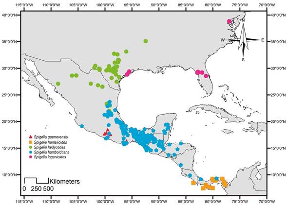
Figure 12: Distribution map of Spigelia guerrerensis L.O. Alvarado & J. Jiménez Ram., Spigelia hamelioides Kunth, Spigelia hedyotidea A. DC., Spigelia humboldtiana Cham. & Schltdl., and Spigelia loganioides (Torr. & A. Gray ex Endl. & Fenzl) A. DC.
Conservation status: Vulnerable (VU). Spigelia guerrerensis is restricted to the states of Guerrero and Oaxaca, where only seven populations and one population, respectively, are known and together cover an area close to EOO: 23,509.99 km2 and AOO: 10,500 km2. Although populations seem abundant, anthropogenic activities in these areas could drastically reduce the number of individuals in the future. In addition, none of the known populations is included in any protected area (Alvarado-Cárdenas and Jiménez-Ramírez, 2015).
Taxonomic remarks: this species is morphologically similar to S. scabrella Benth. due to its infundibuliform corolla, herbaceous habit, shape and size of the leaves. Spigelia guerrerensis can be distinguished by the white color of the corolla, sometimes the margins of the lobes purple, sparsely pubescent styles, inflorescences reduced to one or two flowers and apically hirsute fruits (Alvarado-Cárdenas and Jiménez-Ramírez, 2015).
Specimens examined: MEXICO. Guerrero, municipality Atlixtac, 5 km al E de Atlixtac, camino a Petatlán, 21.VI.2014, R. Cruz-Durán 9186 (FCME); Petatlán, 3.29 km al NO, 19.VII.2002, O. Silva 22 (FCME). Municipality Eduardo Neri, Amatitlán, 11.VIII.1994, R. Cruz-Durán 197 (FCME, MEXU), F. Ramos 197 (MEXU); 11 km al SE de Amatitlán, carr. Amatitlán - Carrizalillo, 13.VIII.1996, R. Cruz-Durán 931 (FCME, MEXU); Amatitlán, 4.7 km al O, 11.VIII.1994, M. A. Monroy 363 (FCME); Cerro el Ocotal, 1.15 km al SE de Amatitlán, 11.VIII.1994, M. A. Monroy 384 (FCME), 392 (FCME). Municipality General Heliodoro Castillo, Los Lavaderos, 5.52 km al N, 18.VII.1999, R. Cruz-Durán 4203 (FCME). Municipality Taxco de Alarcón, Tlamacazopa, 2.VIII.2003, J. A. Almazán 1 (FCME), 6.VII.2002, B. E. Carreto s.n. (FCME). Oaxaca, municipality San Bartolo Yautepec, Tejón, llano para llegar a la reja, 27.VII.2011, D. López 1022 (MEXU).
Spigelia hamelioides Kunth, Nov. Gen. Sp. (H.B.K.) 3: 185. 1818.
TYPE: COLOMBIA. Crescit prope Guaduas Novo-Granatensium, locis temperatis, Alt. 600 hex, floret junio, s.d., F. W. H. A. Humboldt and A. J. A. Bonpland s.n. (holotype: P-0067862!).
= Spigelia multispica Steud., Flora 26: 764. 1843. TYPE: SURINAME. In sylvis distr. Para, s.d., W. R. Hostmann and A. Kappler 851a (holotype: F-790132!, isotypes: G-00368321!, K-00573348!, MO-1686684!, MO-1954958!, P, SR-5848!).
= Spigelia sessilifolia Rusby, Bull. Torrey Bot. Club 25(10): 543. 1898. TYPE: BOLIVIA. Mapiri, 5000 ft., V.1886, H. H. Rusby 1429 (holotype: MICH-1191502!, isotypes: MIN-1002816!, NY-00297400!, NY-00297399!, NY-00297398!, US-00112926!).
= Spigelia filipes Rusby, Descr. S. Amer. Pl. 81. 1920. TYPE: VENEZUELA. Bolivar, Eleanor Creek, lower Orinoco River, s.d., H. H. Rusby and R. W. Squires 145 (holotype: NY-00297394!, isotypes: BM-00757838!, K-00573334!, MIN-1002595!, US-00112912!).
= Spigelia persicarioidesEwan var. insularis Ewan, Caldasia 4: 298. 1947. TYPE: COLOMBIA. Department Nariño, S end of Gorgona island, near sea level, bonk of small stream in dense forest, herb, corolla white, s.d., H. García Barriga and E. Killip 33105 (holotype: US-1770097!, isotypes: BC-635667!, BM-757854!, COL-003969!, MO-112921!, US-00930981!).
= Spigelia killipiEwan, Caldasia 4: 302. 1947. TYPE: COLOMBIA. Chocó, forest near junction of Río Condoto and Río San Juan, alt. 100-150 m, 20.IV.1939, E. Killip 35101 (holotype: US-1771863!, isotypes: BM-00757855!, US-00901886!).
Herbs branched, stem quadrangular, glabrous, with lignification; leaves pseudowhorled below the inflorescence, petiolate, lamina ovate, chartaceous, 10-16 cm long; stipules present, deltate; inflorescence axillary, scorpioid cyme, 20-30 flowers, sessile (Fig. 11E); sepals green, linear; corolla infundibuliform, 0.8-1.8 cm long, tube white, lobes pink or purple, lobes lanceolate; stamens inserted below the middle part of the corolla tube, included, filaments present; pollen not seen; stigma terete, style pubescent; capsule pubescent, 4-6.5 cm diameter, metastyle present, same size as the capsule, carpoatlas rhombic (Fig. 11F), transversal ridge absent; seeds 16, testa rugose.
Distribution and habitat: species distributed in Costa Rica (Limón and Puntarenas), and Panama (Colón, Darién, Panamá, and Veraguas) (Fig. 12). Outside the study area, it is distributed in Venezuela, Colombia, Ecuador, Bolivia, Peru, French Guiana, Guyana, Suriname, and Brazil (Fernández-Casas and Huft, 2009). It lives in humid forests; is recorded from sea level to 160 m elevation.
Conservation status: Least Concern (LC). Spigelia hamelioides is one of the species that is shared between the NA and SA regions (EOO: 350,852.11 km2, AOO: 35,000.00 km2). Its distribution extends to Ecuador, Peru, Bolivia, and Brazil in the Amazon region.
Taxonomic remarks: this species presents morphological characteristics similar to S. humboldtiana in the size of the leaves and flowers, as well as in the pseudowhorled phyllotaxy below the inflorescence. It can be differentiated from the latter by chartaceous leaves (vs. membranous), flowers with pink petals (vs. flowers with white petals), and pubescent capsule (vs. capsule glabrous).
Specimens examined: COSTA RICA. Province Limon, vicinity of Guápiles, 12.III.1924, P. C. Standley 37077 (US). Province Puntarenas, Corcovado, Peninsula de Osa, 16.VIII.1984, P. Acevedo-Rodríguez 487 (US); Parque Nacional Corcovado Sirena, River bank of Río Claro, 6.VII.1991, P. Delprete 5179A (TEX); Osa Peninsula, Corcovado N.P., Sirena Station: Skyway Trail, below intersection with 700 trail from the east, 24.VII.1993, K. Gould 6 (TEX); Osa Peninsula, Corcovado N.P., Sirena Station, Sendero Sal si Puedes, ca. 30-50 m away from the beach, 22.VII.1993, K. Gould 7 (TEX); Osa Peninsula, Corcovado N.P., Sirena Station, Large branch-fall light gap off the Sirena Trail, near the beach, 26.VII.1993, K. Gould 8 (TEX). PANAMA. Province Colón, near mouth of R. Chagres, 15.III.1935, P. H. Allen 902 (US); Chagres, Isthmus of Panama, 1.VI.1850, A. Fendler 283 (US); parque Soberanía, camino del Oleoducto, 3.VI.2015, C. Galdames 7911 (US); mainland opposite Alligandi, from mouth of Alligandi River to 2.5 miles in land, 7.XII.1966, W. H. Lewis 78 (US); vicinity of Forest Sherman, Canal Zone, 15.I.1924, P. C. Standley 30960 (US). Province Darién, vicinity de Pinogana, ca. 20 m, 6.X.1938, P. H. Allen 929 (US); vicinity of Campamento Buena Vista, Río Chucunaque above confluence with Rio Tuquesa, 1.VII.1959, W. L. Stern 812 (US). Province Panamá, Mount Pirri, 12.VI.1912, E. A. Goldman 1962 (US); 12-16 km above Pan - Am hyghway on road from El Llano to Carti-Tupile, 5.V.1973, H. Kennedy 3117 (TEX); deep jungle, Juan Díaz, 6.X.1917, E. P. Killip 3120 (US); summit gardens, weed under cultivated bamboo, 9.IX.1974, S. Morí 1781 (US); Río Tapia, 7.XII.1923, P. C. Standley 28232 (US). Province Veraguas, Rio Pita, 1.3 miles above confluence with Rio Maestra, 14.X.1961, J. A. Duke 4761 (US); Isla de Uva, Contreras group, 11.XII.1911, H. Pittier 5107 (US); Corozal, Canal Zone, 18.XII.1923, P. C. Standley 27389 (US); Río Pedro Miguel, near East Paraíso, Canal Zone, 7.I.1924, P. C. Standley 29926 (US).
Spigelia hedyotidea A. DC., Prodr. 9: 7. 1845.
TYPE: UNITED STATES OF AMERICA. Nuevo Mexico, 1851, C. Wright 1663 (holotype: P-511989!).
= Spigelia coulteriana Benth., J. Proc. Linn. Soc., Bot. 1: 90. 1856. TYPE: MEXICO. Hidalgo, Zimapan, s.d., T. Coulter 962 (holotype: K-00573402!).
= Spigelia lindheimeri A. Gray, Syn. Fl. N. Amer. 2(1): 108. 1878. TYPE: UNITED STATES OF AMERICA. Texas, county Comal, New Braunfels, s.d., F. J. Lindheimer 172 (lectotype: GH-00107111!, designated by Henrickson (1996)).
Herbs branched, stem quadrangular, glabrescent, without lignification; leaves opposite below the inflorescence, sessile or shortly petiolate, lamina lanceolate, coriaceous, 1-2.5 cm long; stipules present, deltate; inflorescence axillary, scorpioid cyme, 5-8 flowers, pedicellate (Fig. 13A); sepals green, linear; corolla infundibuliform, 0.7-1.3 cm long, tube white, lobes white with purple margin, lobes lanceolate; stamens inserted at the middle part of the corolla tube, included, filaments present; pollen not seen; stigma capitate, style pubescent; capsule pubescent, 5.3-6.2 mm diameter, metastyle present, smaller than the capsule, carpoatlas oblong (Fig. 13B), transversal ridge present; seeds elliptic, testa reticulate.

Figure 13: Morphological characters. Spigelia hedyotidea A. DC.: A. inflorescence (Naturalista, 2020d); B. carpoatlas. Spigelia humboldtiana Cham. & Schltdl.: C. inflorescence; D. carpoatlas; E. seed. Spigelia loganioides (Torr. & A. Gray ex Endl. & Fenzl) A. DC.: F. inflorescence (Naturalista, 2019a); G. carpoatlas. Photographic credits: A) T. Eubanks (https://www.naturalista.mx/observations/41206915 © reproducida con autorización del autor); B), C), D), E), G): S. Islas; F) J. Appleget (https://www.naturalista.mx/observations/24228897 CC BY-NC).
Distribution and habitat: species distributed in Mexico (Chihuahua, Coahuila, San Luis Potosí, Sonora, and Tamaulipas) and United States of America (Arkansas and Texas) and (Fig. 12). It lives in tropical deciduous forest from 1400 to 1800 m elevation.
Conservation status: Least Concern (LC). This species has been reported with a broad distribution in the United States of America and Mexico, covering an area of 85,000.00 km2 AOO (EOO: 895,814 km2). Likewise, it has been collected steadily in recent years.
Taxonomic remarks: this species is related to S. texana (Torr. & A. Gray) A. DC. based on the phylogenetic analysis from chloroplast DNA (Gould, 1997). Spigelia hedyotidea can be morphologically differentiated from S. texana by having larger branched stems (vs. monopodic stems), glabrous leaves (vs. papillose leaves), and opposite leaves at the base of the inflorescence (vs. pseudowhorled leaves below the inflorescence).
Specimens examined: MEXICO. Chihuahua, municipality Chihuahua, cerca de Chihuahua, 1.X.1986, C. G. Pringle 839 (MEXU). Municipality Julimes, S slope and top of Sierra del Roque, NNE of Julimes, approaches from Mina Las Playas vía Rancho El Saucito, 19.VI.1973, M. C. Johnston 11389 (TEX); Sierra del Roque N of Julimes and NW of Rancho el Sauz, 24.VIII.1973, M. C. Johnston 12337 (TEX). Coahuila, municipality Cuatro Ciénegas, cañon de la Madera in middle narrow winding portion of Trail Fork, ca. 2.1/4 mi. above jct. with West Fork, 29.III.1975, T. Wendt 842 (TEX). Municipality Sierra de la Gloria, cañón El Cono, a side cyn. of C. Chipitín, draining in from N near El Chipitín, below lowest pouroff several hundred m in steep-walled limestone cyn, 6.IX.1976, T. Wendt 1654 (TEX). San Luis Potosí, municipality Ciudad Valles, San Dieguito, 13.VI.1904, E. Palmer 86 (US), 461 (US). Sonora, municipality Alamos, Arroyo Santa Bárbara, 21.X.1992, P. Jenkins 92-98 (TEX). Tamaulipas, municipality Bustamante, road to Bustamante, 4.8 mi W of hwy 101, steep, W-facing slope overlooking valley, 15.VI.1987, G. Nesom 5989 (TEX). Municipality Gómez Farías, Río Sabinas, bajo el puente en la carretera Mante - Llera, 23.X.1999, A. Mora-Olivo 7759 (MEXU). Municipality Jaumave, Jaumave, 1.V.1930, H. W. Viereck 362 (US). Municipality Tula, 18 km SE of Bustamante toward La Presita and Tula by winding road, 20.V.1973, M. C. Johnston 11158 (TEX), 11172 (TEX). UNITED STATES OF AMERICA. Arkansas, County Conway, near Conway Hillside, 17.V.1931, A. Haas 252 (US). Texas, County Austin, Travis, 6.X.1936, B. C. Tharp 1328 (TEX); loc. cit. 5.IV.1922, B. C. Tharp 44445 (TEX); loc. cit., 9.V.1935, B. C. Tharp s.n. (TEX); along bank of Shoal Cr., 22.III.1916, M. S. Young s.n. (TEX). County Bandera, near contact with the lower part of Fort Terrett Member of Edwards Limestone, canyon of Madrone Creek, in and around minor side drainage, ca. 1.1 air miles SSE to SE of NW corner of park, 4.V.1995, W. R. Carr 14586 (TEX); Love Creek Nature Preserve, 10 miles east of Medina, on hwy. 337, along creek below stand #7, 5.VI.2001, G. Denny 193 (TEX); Love Creek Nature Preserve, 10 miles E of Medina, on hwy. 337, 7.III.2001, G. Denny 309 (TEX); Hill Country State Natural Area, 23.VI.1996, K. Gould 148 (TEX), 157 (TEX). County Bell, training Area LTA 115, along north side of Rappelling Road, 0.5 mi east of Union Hill Roas, 12.V.2008, L. L. Hansen 5903 (TEX). County Bexar, Gouverment Canyon, ca. 0.3 mi NNE of spring, ca. 51 air miles N of intersection of Galm Rd. and R.M. 471, San Geronimo Quadrangle, 22.IX.1992, W. R. Carr 12365 (TEX); Mayberry tract. NE corner of tract, ca. 3.7 air miles NNE of jct. RM 471 and RM 1283, San Geronimo Quadrangle, 17.V.2001, W. R. Carr 19732 (TEX); Government Canyon State Natural Area, at the edge of Govt. Creek just below Zizelman Cottage, 30.VI.2003, E. Lott 4406 (TEX); Government Canyon Natural Area, small W facing cliff just off the road which runs through W side of Park along Government Crek, 16.VIII.2003, E. Lott 4582 (TEX). County Brazoria, Columbia, 24.IV.1900, B. F. Bush 148 (US). County Burnet, 1.3 mi E on dirt road near creek 8.8mi S of Lampasas on 183, 4.VI.1966, J. A. Mears s.n. (TEX). County Gillespie, 1.3 mi E on dirt road near creek 8.8mi S of Lampasas on 183, 2.V.1994, K. Gould s.n. (TEX). County Goliad, at SW corner of tank, E side of road to HQ ca. 2 mi N of its jct. with FM 1351, Naval Auxiliary Landing Field, Goliad, Berclair Quadrangle, 15.IV.1992, W. R. Carr 11814 (TEX). County Guadalupe, Seguin, 28.IV.1942, H. B. Parks 1847 (TEX); near Seguin, 18.VII.1942, H. B. Parks 39592 (TEX). County Hays, Purola Ranch on Hays Co. 187 (McGregor Lane), 2.7 mi N of Hays 101 (Fitzhugh Road), 21.V.2000, B. Harms 3 (TEX). County Johnson, Tank Creek, south of Crawford, astream bank, 7.V.1947, L. D. Smith 558 (TEX). County Karnes, 5.5 miles southwest of Karnes City, 19.IV.1957, D. S. Correll 16055 (TEX). County Kendall, rare in juniper-oak woodland on gentle drysh slopes of shallow, moderately mesic canyon in Glen Rose Limestone, ca. 12 air miles NE to NNE of St. Rt. 46 bridge over Red Bluff Creek, 16.VI.2014, W. R. Carr 34019 (TEX); in dry soil in woodland below Edge Falls, 3.V.1947, B. C. Tharp 17T139 (TEX). County Kimble, Walter Buck wildlife management area, in hunt area 1, near House Blind 1, 12.V.2007, L. L. Hansen 4846 (TEX); loc. cit., 30.V.2009, L. L. Hansen 6580 (TEX). County Kleberg, NE corner of Nimitz ans Sellers, Naval Air Station Kingsville, 1.7 air miles ESE of jct. US Rt. 77 and F.M. 425, 2,1 air miles NE of jct. F.M 1717 and F.M. 1720, Ricardo Quadrangle, 26.III.2007, W. R. Carr 25632 (TEX). County McLennan, middle Bosque River, 1st crossing, north bank, 2.V.1947, L. D. Smith 507 (TEX). County McMullen, W part of US Navy's Escondido Ranch, ca. 2.2 air miles E to ESE of Nueces River crossing of La Salle County line, ca. 3.2 air miles NE of jct. of McMullen, Duval, La Salle, and Webb county lines, Piedra Creel SE Quadrangle, 27.X.2006, W. R. Carr 25288 (TEX). County Palo Pinto, NW Palo Pinto Co. Rocky limestone and sandstone hills above Possum Kingdom State Park, 17.V.1947, R. McVaugh 8342 (TEX). County Parker, ca. 2.9 air miles NNW of US Rt. 377 bridge over Bear Creek, Bear Creek Unit of Dixon Ranch, Cresson Quadrangle, 17.VI.2009, W. R. Carr 28161 (TEX). County Terrell, Meyers Spring Ranch, Meyers Canyon Quadrangle, 20.IV.2005, W. R. Carr 23781 (TEX); cultivated in U.T. Austin Greenhouses, 1.VII.1997, K. Gould 158 (TEX); rocky creek-bed of Independence Creek, 1 mile above its junction with the Pecos River, 22.VI.1989, G. L. Webster 392 (TEX). County Uvalde, W bank of Frio River, 500-1000 ft S. of mouth of intermittent creek S of park HQ, Garner State Park, Magers Crossing Quadrangle, 10.V.1995, W. R. Carr 14624 (TEX). County Val Verde, W-draining canyon E of Grass Patch Springs, 0.1-0.5 mi E of Devils River, Dolan Falls Ranch, Clark Waterhole Quadrangle, 26.III.1997, W. R. Carr 15909 (TEX); NW-facing bluff, in Bluff Canyon ca. 1/4 to 3/4 mi upstream from (NE of) its mouth at Devils River, Telephone Canyon Quadrangle, 6.V.2003, W. R. Carr 22009 (TEX); Grass Patch Springs, ca. 0.8-0.9 air miles S of Dolan Falls, 7.X.2008, W. R. Carr 27245 (TEX); Salmon Peak Limestone, ca. 0.5-0.6 air miles NE of TPWD bunkhouse, ca. 8-9 air miles NW of jet. US Rt. 227 and road to Rough Canyon Recreation Area, 11.IV.2012, W. R. Carr 30330 (TEX); Dolan Falls Ranch, TNC, Canyon of Dolan Creek, just below "Canyon wren family" grotto, 29.V.1994, K. Gould 108 (TEX), 111 (TEX); along bank of Devil's River at Fawcett Ledge 20-30 mi up river, 3.IV.1953, B. H. Warnock 11345 (TEX).
Spigelia humboldtiana Cham. & Schltdl., Linnaea 1(2): 200. 1826.
TYPE: VENEZUELA. Sucre, habitat ad Cumaná, 1799, F. W. H. A. Humboldt and A. J. A. Bonpland 174 (lectotype: BW-3552!, designated by Ewan (1947); isolectotype: P-507553!).
= Spigelia scabra Cham. & Schltdl., Linnaea 1(2): 202. 1826. TYPE: BRAZIL. In provincia Cisplatina Brasiliae, Montevideo, s.d., F. Sellow 1477 (holotype, B, isotype: HAL-69906!).
= Spigelia scabra var. angustataProgel, Fl. Bras. (Martius) 6(1): 261. 1868. TYPE: BRAZIL. Rio de Janeiro, Petrópolis, Caxambu, s.d., A. F. M. Glaziou s.n. (holotype: BR-111043!).
= Spigelia humboldtiana var. obtusifoliaProgel, Fl. Bras. (Martius) 6(1): 261. 1868. TYPE: BRAZIL. Brasilia, ad fl. Paraiba. s.d., P. M. Vidensis s.n. (holotype: BR-6594893!).
= Spigelia humboldtiana var. pubescensProgel, Fl. Bras. (Martius) 6(1): 261. 1868. TYPE: BRAZIL. Brasilia, in prov. Minarum sylvis orientalibus, s.d., F. Sellow s.n. (holotype: MPU-013245).
= Spigelia palmeri Rose, Contr. U.S. Natl. Herb. 1: 342. 1895. TYPE: MEXICO. Colima, in wet places across the lagoon from Manzanillo, s.d., E. Palmer 929 (holotype: US-112919!).
= Spigelia rubelliana Arechav., Anales Mus. Nac. Montevideo ser. 2, 1: 61, fig. 1. 1911. TYPE: URUGUAY. Rivera, Cuchilla Negra, s.d., Anonyme s.n. (holotype: S-I25771!).
= Spigelia chamaedryoides Kraensl., Repert. Spec. Nov. Regni Veg. 14: 293. 1916. TYPE: ARGENTINA. Misiones, Posadas y suburbios, s.d., A. A. Muniez 12 (holotype: G-368322!, isotypes: GH, MO-1686669!).
= Spigelia australis L.B. Sm., Wrightia 2: 101, fig. 19 p-q. 1960. TYPE: BRAZIL. Santa Catarina, collected in pinheiral (Araucaria forest), 33 km W of Cacador, s.d., D. L. Smith and R. Reitz 9104 (holotype: US-2280007!, isotypes: HBR, R).
Herbs branched, stem quadrangular, glabrous, without lignification; leaves pseudowhorled below the inflorescence, shortly petiolate, lamina ovate, membranaceous, 1.5-12 cm long; stipules present, deltate; inflorescence terminal, scorpioid cyme, 5-13 flowers, sessile (Fig. 13C); sepals green, linear; corolla infundibuliform, 4.5-6 cm long, tube white, lobes white with purple lines, lobes ovate; stamens inserted at the middle part of the corolla tube, included, filaments present; pollen in monads, oblate-spheroidal, with medium polar area, 3 simple apertures, without margo on the colpi; stigma capitate, style pubescent; capsule glabrous, 4-4.5 cm diameter, metastyle present, smaller than the capsule, carpoatlas elliptic (Fig. 13D), transversal ridge present; seeds trullate-ovoid, testa reticulate (Fig. 13E).
Distribution and habitat: species distributed in Mexico (Campeche, Chiapas, Colima, Guanajuato, Guerrero, Oaxaca, Puebla, Querétaro, Quintana Roo, San Luis Potosí, Tabasco, Tamaulipas, Veracruz, and Yucatán), Belize (Cayo; Fernández-Casas and Huft, 2009), Guatemala (Alta Verapaz, Baja Verapaz, Izabal, Petén and Quetzaltenango), Honduras, El Salvador (Morazán), Nicaragua (Managua), Costa Rica (Puntarenas and San José), and Panama (Bocas del Toro and Colón) (Fig. 12). Outside the study area, it is distributed in Venezuela, Colombia, Ecuador, Peru, Bolivia, Paraguay, Uruguay, Argentina (Bravo, 1971), Guyana, and Brazil (Fernández-Casas and Huft, 2009). It inhabits thorny forest, mountain mesophilic forest, Quercus forest, deciduous and semi-deciduous tropical forest, humid tropical forest and scrub. It is found from sea level to 2700 m elevation.
Conservation status: Least Concern (LC). This species is widely distributed from Mexico to South America (EOO: 1,770,505.72 km2, AOO: 265,500 km2). Together with S. anthelmia, they are the species with the largest distribution in the continent and introduced in Africa, Asia, and Europe. It is distributed mainly along the coasts and has been recorded in protected areas and botanical gardens. Therefore, it is not considered under any type of threat.
Taxonomic remarks: Together with S. scabra, the species were published simultaneously by Chamisso and Schlechtendal (1826). Blackwell (1967) was the first to place S. scabra in synonymy under S. humboldtiana (Fernández Casas y Huft, 2009), so from that moment the priority of this name is established in accordance with the International Code of Nomenclature for Algae, Fungi and Plants (Art. 11.5; Turland et al., 2018).
In the publication of the species, Chamisso & Schlechtendal mention that, despite its similarity, S. scabra was more robust, which is why they separate them into different entities. Bravo (1971), in his work on the Argentinian species of Spigelia, carried out a quantitative analysis of the variability in S. humboldtiana of different morphological characters (length and width of the leaf, length of the calyx, mature calyx-capsule ratio, roughness, stipules) that were considered for the separation of S. scabra as a different species. The characters analyzed in 201 specimens present a normal distribution and a continuous variation within the species, for which they are not considered of taxonomic importance to differentiate between species. Therefore, here we follow the proposal of Bravo to keep S. humboldtiana as the accepted name, subordinating S. scabra as a synonym.
Specimens examined: BELIZE. District Cayo, in high ridge, on hillside, Hummingbird highway, 1.VI.1954, P. H. Gentle 8193 (TEX); dry creek, Hummingbird highway, 18.X.1954, P. H. Gentle 8407 (TEX); in high ridge, hillside, Hummingbird Gap, Hummingbird highway, 15.VIII.1956, P. H. Gentle 9214 (TEX). COSTA RICA. Province Puntarenas, Corcovado National Park, Osa Peninsula, 8.IX.2000, D. Goldman 1543 (TEX); Corcovado National Park, cultivated in U.T. Austin Greenhouses, 5.VIII.1997, K. Gould 162 (TEX). Province San José, cerca de la Universidad de la Paz, aproximadamente 6 km al suroeste de la Ciudad de Colón (Villa Colón), 15.VIII.1989, O. Dobbeler 1648 (MEX). EL SALVADOR. Department Morazán, Finca of General J. T. Calderón, Montes de Cacaguatique, 27.XII.1941, J. M. Tucker 632 (TEX). GUATEMALA. Department Alta Verapaz, Sebol, bordering Río Sebol, about 12 km below Río Sebol, 11.IV.1964, E. Contreras 4222 (TEX); Chapultepec farm, 62 km of Coban on Sebol Coban Road, in low forest bordering arroyo, 25.V.1964, E. Contreras 4791 (TEX); rest stop, swimming hole at head of trail to caves, 11.V.1994, K. Gould 53 (TEX); Semuc Champey, 11.VI.1994, K. Gould 54 (TEX), 55 (TEX); gravel road from Senahú to Finca Sepcuite, not far up from intersection leading to Sepacuite, 14.VI.1994, K. Gould 58 (TEX), 59 (TEX). Department Baja Verapaz, Union Barrios, on hilltop, in high forest, east of km 154, 15.IV.1975, C. L. Lundell 19204 (TEX). Department Izabal, El Estor, 21.III.1972, E. Contreras 11434 (TEX); Finca El Zapotillo, N shore of Lake Izabal, E of El Estor, 17.V.1966, G. C. Jones 3426 (TEX); along Río Bonita, 21.XII.1941, J. A. Steyermark 41720 (TEX). Department Petén, Dolores, in high forest, between km 83/84 of Machaquila road, 24.IV.1961, E. Contreras 2169 (TEX), 2170 (TEX), 2813 (TEX); Dolores, on Santo Toribio trail, 27.V.1961, E. Contreras 2386 (TEX); Lacandón, on El Caribal, in acahual about 500 m SW, 8.II.1962, E. Contreras 3367 (TEX). Department Quetzaltenango, 16.6 km S of intersection to Zunil at toll booth on hwy. 9S (13.7 km S of S. María de Jesús), 2.VI.1994, K. Gould 20 (TEX); 2.6 km from intersection, S on paved road to El Palmar; at bridge over stream, trail into 2nd growth old banana plantation, 3.VI.1994, K. Gould 23 (TEX). MEXICO. Campeche, municipality Candelaria, Azulillo, 7.VIII.1983, Grupo Roya 37 (XAL). Municipality Tenabo, 1 km carretera Tenabo - Kankí, 27.X.1997, P. Zamora 5804 (CICY). Chiapas, municipality Acacoyagua, cercanías de Acacoyagua, 16.II.1969, R. Hernández 529 (MEXU); Cerro Ovando, polígono zona de amortiguamiento, 22.VII.2005, N. Martínez 941 (FCME, MEXU). Municipality Berriozábal, Berriozábal, 30.VIII.1953, F. Miranda 7880 (MEXU); cerca de Cañón del Sumidero, 2.XII.2000, R. A. Palestina 2338 (XAL). Municipality Cacahoatán, Finca Guatimoc, 28.IX.1956, G. Guzman 115 (ENCB); B. Alpujarraz, 3.XI.1941, F. Miranda 1771 (MEXU). Municipality Chiapa de Corzo, carretera mexicana 190 en el paraje Zinacantán de Muktajok, 26.IX.1972, D. E. Breedlove 27999 (MEXU). Municipality Chilón, Patetehel, 1 km al SE del Templo, 10.IV.1990, L. Ambriz 1 (IMSS, XAL). Municipality Escuintla, Escuintla, 1.XII.1937, E. Matuda 2113 (MEXU); Cacaluta, 3.IX.1947, E. Matuda 16989 (MEXU); Mt. Ovando, 5.V.1948, E. Matuda s.n. (MEXU). Municipality Huixtla, Huixtla, 18.IV.1980, S. Quintero 247 (XAL). Municipality Ixtacomitán, 2 km al E de Ixtacomitán, camino Villahermosa - Tuxtla Gutiérrez, 11.II.1983, E. Martínez 3152 (MEXU). Municipality La Concordia, paraje El Mezcalar, Predio Particular Arroyo Negro, 17.VI.1989, U. Bachem 968 (MEXU, UAMIZ); finca Las Nubes, polígono zona de amortiguamiento, 6.IV.2005, J. Martínez 517 (MEXU); aprox. 1 km al NO del Rancho Buenavista III, 6.IV.2005, J. Martínez 551 (FCME, MEXU); finca Santa Cruz, 25.IV.2005, J. Martínez 789 (FCME, MEXU); aprox. a 300 m antes del Rancho del Vergel, 8.VI.2005, J. Martínez 926 (FCME); a 3.5 km al N del Rancho El Vergel, 5.IX.2005, J. Martínez 1008 (FCME); finca Cuxtepeques, polígono zona de amortiguamiento, 14.VI.2006, N. Méndez 71 (MEXU); a 6 km al N de finca Custepec, sobre el camino a finca El Porvenir, 13.VII.1990, A. Reyes-García 1864 (INEGI, MEXU). Municipality La Independencia, cerca de la carretera, 14.III.1981, F. Madero 1931 (MEXU). Municipality La Trinitaria, cerca de Cinco Lagos, parque Lagos de Montebello, 5.X.1981, D. E. Breedlove 53330 (MEXU, TEX). Municipality Mapastepec, reserva El Triunfo, polígono 1, cañada Honda - El Tomatal, 23.IV.1990, M. Heath 886 (MEXU, OAX, UAMIZ, XAL). Municipality Ocosingo, rancho El Edén a 3 km del poblado Nuevo Guerrero, 8.III.2002, G. Aguilar 87 (MEXU); restaurante La Escondida, en la 11 de Julio camino a Palenque, 12.VI.2002, G. Aguilar 1378 (MEXU); al E del crucero San Javier, 26.VIII.2002, G. Aguilar 2330 (MEXU); El Encaño a 3.2 km al NO de Naité, 20.IX.2002, G. Aguilar 2951 (MEXU), 2952 (MEXU); poblado Chansayab, 19.X.2002, G. Aguilar 3848 (MEXU, XAL); crucero Bethel, 20.X.2002, G. Aguilar 3911 (MEXU, XAL); a 9 km al NO del crucero San Javier, 12.XII.2002, G. Aguilar 4613 (MEXU); a 2.4 km al NE del ejido Mariscal, 16.II.2003, G. Aguilar 5811 (MEXU, XAL); a 1.8 km al E del crucero Bonampak, 19.VI.2003, G. Aguilar 7133 (MEXU); a 2.98 km al S del crucero San Javier, 20.XII.2003, G. Aguilar 9016 (MEXU); a 3.89 km al E del Poblado de Nuevo Guerrero, 25.XII.2003, G. Aguilar 9149 (MEXU); a 1.81 km al S de Frontera Corozal, 13.V.2004, G. Aguilar 10022 (MEXU); a 1.63 km de frontera Corozal al SE, 4.VI.2004, G. Aguilar 10439 (MEXU); a 2.42 km al SE de Frontera Corozal, 21.X.2004, G. Aguilar 11779 (MEXU); a 2.1 km al SE de la comunidad Lacanjá Chansayab, 17.VI.2003, D. Álvarez 5387 (MEXU, XAL); low ridges at the confluence of Río Ixcán with Rio Lacantum (Río Jataté) on the Guatemala border, 14.III.1973, D. E. Breedlove 34122 (MEXU); a 0.6 km al S de Nuevo Guerrero, arroyo la poza, 12.X.2002, J. Calónico 2429 (MEXU); a 4 km al E de Nuevo Guerrero, 5.V.2002, J. Calónico 23126 (MEXU, XAL); a. 3.8 km al SE de Nuevo Guerrero, 5.V.2002, J. Calónico 23251 (IBUG, MEXU, XAL); a 3.7 km al E de Nuevo Guerrero, 17.X.2002, J. Calónico 24596 (MEXU, XAL); a 0.4 km al N de Lacanjá Chansayab, 19.X.2002, J. Calónico 24692 (MEXU); Arroyo Miranda, de la boca a más o menos 8 km adentro, frente al poblado de Chajul, 22.II.1985, G. Castillo 4090 (IEB, MEXU, XAL); comunidad lacandona de Nahá 27 km al SE de Palenque, por la carretera hacia el crucero Chancalá, después de 55.6 km por el camino de terracería hacia Monte Líbano, 14.IV.1995, A. Durán 327 (MEXU); orilla del río Lacantún, estación Chajul, Reserva Montes Azules, 31.X.2003, I. García 111A (INEGI); 1.5 km al SO de Bonampak, rumbo a Lacanjá, 26.III.1990, M. Gonzáles 1008 (MEXU); 1.5 km sobre la desviación a Bonampak, viniendo de San Javier, 7.VI.1990, M. Gonzáles 1092 (MEXU); comunidad lacandona de Lacanha-Chinsayab, a 130 km al SE de Palenque, por la carretera fronteriza hasta el crucero San Javier, después 8 km al O, 20.VII.1995, S. Levy 483 (MEXU); a 4 km al S de ejido Benemérito de las Américas, 18.II.1985, E. Martínez 10761 (MEXU); a 4 km al S de ejido Benemérito de las Américas, camino a Flor de Cacao, 18.II.1985, E. Martínez 10762 (MEXU); a 15 km al NO de Boca Lacantum, camino a Palenque, 13.IX.1985, E. Martínez 13744 (MEXU); en zona Marqués de Comillas, a 4 km al E de Pico de Oro camino a ejido Benemérito de las Américas, Arroyo Salado, 21.I.1986, E. Martínez 16525 (CICY, MEXU); zona Marqués de Comillas, Arroyo el Salado a 4 km al E de Pico de Oro camino a ejido Benemérito de la Américas, 21.I.1986, E. Martínez 16538 (MEXU); a 2 km al N de Naja camino a Chancala, 17.VI.1986, E. Martínez 18778 (CICY); a 50 km al S de Boca Lacantum, 24.VI.1986, E. Martínez 19007 (CICY); a 12 km al E de Pico de Oro camino Benemérito de las Américas, 24.VI.1986, E. Martínez 19028 (CICY, IEB, MEXU); al N de Yaxchilán, sobre el río Usumacinta, límite de los ejidos Ojo de Agua y San Jacinto, 8.V.1988, E. Martínez 22666 (CICY, MEXU); en estación Chajul, 20.VII.1992, E. Martínez 25012 (UAMIZ), 13.XII.1992, E. Martínez 25841 (UAMIZ, XAL); Centro Arqueológico Bonampak, 24.VI.1982, J. Meave 674 (ENCB, FCME, IEB, MEXU, XAL); finca Prusia - Arroyo Chorro, 22.II.1951, F. Miranda 6983 (MEXU); vereda de Puente Hamaca a la Sábana, 31.III.2014, G. A. Salazar 8649 (MEXU); camino a la sabana, s.f., S. Sinaca 1094 (MEXU); alrededor del poblado de Bonfil, 23.XI.1976, F. E. Valdivia 2314 (XAL); 87 mi SW de Tuxtla Gutiérrez, 23.VI.1962, G. L. Webster 11662 (MEXU). Municipality Ocozocoautla de Espinosa, 9 km al NW Emilio Rabasa, 0.5 km al SW El Aquajito, 26.II.1992, S. Ochoa 3812 (XAL); 0.16 km al SE de CNC, 6.XII.2000, R. A. Palestina 2924 (XAL); El Chapopote, km 19 carr. Ocozocoautla - Apic Pac, 1.VIII.1988, F. Pimentel 59 (MEXU); alrededor del poblado de Bonfil, 23.XI.1976, P. E. Valdivia 2314 (MEXU). Municipality Osumacinta, entre Soyaló y la Bombona, camino a Chicoasen, 10 km al W de Soyaló, 7.VIII.1981, D. E. Breedlove 51969 (ENCB). Municipality Palenque, 6-12 km al S de Palenque en el camino a Ocosingo, 27.VII.1972, D. E. Breedlove 26606 (MEXU); en los alrededores de la zona Arqueológica de Palenque, 5.III.1982, E. Cabrera 1927 (MEXU). Municipality Pueblo Nuevo Solistahuacán, cerca de Pueblo Nuevo Solistahuacán, 22.VIII.1967, O. F. Clarke 428 (MEXU). Municipality Reforma, Macayo - Naranjo, 5.X.1996, P. Tenorio 19465 (MEXU). Municipality Salto de Agua, en Mizol-Ha, aprox. 40 km al S de Palenque sobre la carretera Catazaja - Ocosingo, 19.XI.1986, E. Cabrera 12370 (MEXU, TEX); 19.2 km de la desviación a las ruinas, camino de Palenque a Ocosingo, por la Cascada Misolha, 8.X.1984, M. J. Hutt 2423 (MEXU). Municipality Solosuchiapa, steep walled canyon along a fat moving stream, 2-4 km below Ixhuatán along the road to Pichucalco, 8.V.1973, D. E. Breedlove 3489 (MEXU). Municipality Suchiate, Río Cahuacán, 11.VI.1986, E. Ventura 3783 (OAX, XAL). Municipality Tapachula, Mt. Tacana, 1.VIII.1938, E. Matuda 2499 (MEXU); Viva México, 14.VIII.1984, E. Ventura 172 (MEXU); Panpuapa, 20.IX.1984, E. Ventura 318 (CICY, MEXU, UAMIZ, XAL); Nuevo México, 18.VI.1985, E. Ventura 1924 (MEXU, OAX, XAL); Cantón El Tesoro, 3.IX.1985, E. Ventura 2344 (MEXU, XAL). Municipality Totolapa, 6-8 km al W de Teopisca al lado del Cerro Chenek'ultik, 16.VIII.1972, D. E. Breedlove 27025 (ENCB). Municipality Tuxtla Chico, Primero de Cahuacán, 6.VI.1985, E. Ventura 1857 (CICY, MEXU); Río Cahuacán, 11.VI.1986, E. Ventura 3783 (MEXU). Municipality Tuxtla Gutiérrez, sendero al N del mirador los Chiapa, Parque Nacional Cañón del Sumidero, 27.VII.2007, J. A. Espinosa 377 (MEXU); al SE de Tuxtla Gutiérrez, 10.VII.1949, F. Miranda 5363 (MEXU); El Zapotal, al SE de Tuxtla Gutiérrez, 3.VII.1991, E. Palacios 1901 (FCME, IBUG); mirador La Coyota, 15 km al N de Tuxtla Gutiérrez, 8.XII.1980, T. P. Ramamoorthy 1383 (MEXU); en el mirador La Coyota, 17 km al N de Tuxtla Gutiérrez, en el Cañón del Sumidero, 3.VII.1990, A. Reyes-García 1745 (INEGI, MEXU); a 16 km al NE de Tuxtla Gutiérrez, Cañón del Sumidero, 1.X.1984, R. Torres 6368 (MEXU). Municipality Unión Juárez, ejido Talguian, 8.IX.1977, J. I. Calzada 3732 (XAL); Volcán Tacaná, entre Talquién y Toniná, 7.V.1987, E. Martínez 20748 (MEXU); Unión Juárez, 14.VI.1985, E. Ventura 1913 (MEXU, XAL); San Lázaro, 28.VIII.1985, E. Ventura 2319 (HUMO, IEB, UAMIZ, XAL); Cerro del Carmen, 6 km al S de Unión Juárez, 7.VII.1987, E. Ventura 4612 (IEB, MEXU); 1.5 km antes de Unión Juárez, Cacahoatán - U. Juárez, Región Soconusco, 4.XII.1986, A. Vernet s.n. (MEXU). Municipality Villa Corzo, ejido Sierra Morena, en las faldas del Cerro Bola, 4.VIII.2002, L. O. Alvarado 257 (MEXU); cerro La Peña, al O del ejido Sierra Morena, 19.X.2002, L. O. Alvarado 594 (MEXU); a 2.28 km al O de Sierra Morena, 10.VII.2004, D. Álvarez 10014 (MEXU); colonia Vicente Guerrero a los largo del camino a la Finca Cuxtepeques, 11.IX.1976, D. E. Breedlove 40030 (MEXU); rancho San Pascualito, hacia Rancho Palmeiras, 27.IV.2002, F. Hernández 811 (MEXU); La Antorcha, 22.VI.2003, D. N. López 59 (MEXU, XAL); rancho San Rafael, 23.VI.2003, J. Martínez 281 (MEXU); El Amatal, 14.IX.2003, J. Martínez 363 (FCME); Rancho 3 hermanos, 3.X.2003, E. Meléndez 1288 (MEXU); ejido Sierra Morena, 31.V.2002, A. Reyes-García 4854 (MEXU); loc. cit., 12.VII.2004, A. Reyes-García 7111 (MEXU); en el predio Monterrey, cerca al arroyo "Salto Chiquito", 5.VIII.2002, A. Reyes-García 5252 (MEXU). Municipality Villaflores, Reserva de la Biosfera de la Sepultura, 6.VII.2004, D. Álvarez 9709 (MEXU); rancho Concepción (Adelante Caté), 1.X.1950, F. Miranda 6700 (MEXU); en el ejido El Paraíso, 29.V.2002, A. Reyes-García 4745 (MEXU). Colima, municipality Manzanillo, 12 km from Manzanillo, 8.VIII.1938, C. R. Worth 8610 (US). Guanajuato, municipality Artarjea, El Banco, 10 km al SO de Atarjea, 9.XI.1988, E. Ventura 6345 (IEB). Municipality Xichú, 13 km a l W de Xichú, sobre la carretera a San Luis de la Paz, 30.X.1986, J. Rzedowski 41581 (IEB, UAMIZ); Río Álamo, 15 km al N de Xichú, 8.IX.1989, E. Ventura 7255 (IEB, QMEX); 2 km al S de Agua Zarca, por la carretera a Xichú, 20.IX.2006, S. Zamudio 13628 (IEB). Guerrero, municipality Acapulco de Juárez, Acapulco, 21.XII.1944, F. Miranda 3343 (MEXU). Municipality Juan R. Escudero, El Zapote, 15.VII.2010, J. Maldonado 6799 (FCME). Municipality Mártir de Cuilapan, La Esperanza (Reserva campesina), 17.VII.1997, C. Teyuco s.n. (FCME). Oaxaca, municipality Acatlán de Pérez Figueroa, Cerro del Tigre 3 km al este de Acatlán vía Tierra Blanca - Alcatán, 25.VIII.1986, L. Cortés 473 (IEB, MEXU); cerro Concordia, 14.IV.1933, C. V. Morton 2535 (US). Municipality Pochutla, Cerro Espino, al E de la finca cafetalera Montecristo, 24.II.1988, A. Campos 1502 (MEXU); Azulillo Candelaria, 22.IX.1983, Grupo Roya 89 (XAL). Municipality San Felipe Usila, en la periferia de la comunidad Santa Cruz Tepetotutla, 7.V.1995, M. A. Romero-Romero 2908 (MEXU). Municipality San José Tenango, 4.5 km al ONO de San Martín Caballero, 22.V.1994, J. Calónico 894 (FCME); aprox. 600 m al NW de San Martín Caballero, por la vereda a Tenango, 23.IX.1999, X. Munn-Estrada 443 (TEX). Municipality San Juan Bautista Tuxtepec, Chiltepec, 15.VII.1965, G. Martínez 123 (MEXU); loc. cit., 1.I.1941, G. Martínez 226 (MEXU, TEX); loc. cit., G. Martínez 459 (MEXU, TEX); loc. cit., 17.IX.1950, D. Ramírez 5 (MEXU). Municipality San Juan Lalana, senda de Santiago Jalahul al Río Cuñeta, 23.VI.1991, J. I. Calzada 17031 (MEXU). Municipality San Miguel Chimalapa, camino a Chocomanantlán - La Ciénega, ca. 10 km en línea recta al E de Benito Juárez cerca del límite con Chiapas, ca. 40 km al NNE de San Pedro Tapanatepec, 26.III.1985, S. Maya 1427 (MEXU); Las Guayabitas, ca. 2 km al N de Benito Juárez por el Río Portamonedas, ca. 30 km en línea recta al N de San Pedro Tapanatepec, 9.VII.1985, S. Maya 1882 (MEXU). Municipality San Miguel del Puerto, Rancho El Lobo, 500 m al SE, 17.IV.2000, F. López 90 (MEXU); Las Trancas de Santa Rosa, 16.VI.2002, F. López 200 (MEXU); Cafetal el Rosal, 6.VI.2003, J. Pascual 790 (IEB, MEXU); Copalitilla, cascada del río, 26.X.1999, C. Perret 769 (MEXU); Xadani, 2.8 km al W, por la brecha a San Miguel del Puerto, 30.VII.1999, J. Rivera 1784 (MEXU, SERO); La Corocera, Santa Maria Petatengo, 3.VIII.2009, A. Sánchez 2814 (MEXU); finca Montecarlo, 600 m al N, 31.V.2001, A. Saynes 2180 (IEB, MEXU, QMEX). Municipality San Miguel Soyaltepec, 3 km al sur de la hidroeléctrica Temazcal, camino Temazcal - Vertedor, 20.V.1986, L. Cortes 326 (MEXU); cerros kársticos que están enfrente de la caseta de vigilancia de los vertederos de la Presa Miguel Alemán, Temazcal cruzando el puente a mano derecha, 23.IX.1984, R. Torres 6147 (MEXU). Municipality San Pedro Pochutla, Pochutla, a 9 km al NE de Chacalapa por camino a finca Monte Cristo, 1.VII.1984, H. M. Hernández 419 (ENCB); a 5 km de la desv. a Totoltepec, de la carr. Pochutla - Oaxaca, 19.II.1984, P. Tenorio 5499 (MEXU); 1.5 km al E de la desv. a Totoltepec, hacia las fincas Dolores e Independencia, la desv. está 4 km al N de Chacalapa, 19.II.1984, R. Torres 4685 (MEXU, TEX); Cerro Espino, finca Montecristo entrando por Chacalapa 5 km al N de Pochutla carr. a Oaxaca, 31.V.1984, R. Torres 5236 (MEXU, TEX). Municipality Santa María Chimalapa, cerca de Chocomanantlán, en el crucero de caminos que va a Los Pericos y a Benito Juárez, ca. 42 km en línea recta al NNE de San Pedro Tapanatepec, 28.VI.1986, S. Maya 3476 (MEXU); San Antonio Nuevo Paraíso, a 1 km en línea recta al W, por el camino al Plan de la Ceiba, 26.VI.1999, J. Rivera 1347 (MEXU); Cabecera del Río Solosúchil, Arroyo Garrobo, Sierra Tres Picos, 14.IV.1996, P. Tenorio 19241 (MEXU), 19316 (INEGI, MEXU). Municipality Santa María Huatulco, San José Cuajinicuil, 13.9 km N, 1 km antes de llegar a Finca Alemania, 27.X.1999, C. Perret 787 (MEXU). Municipality Santa María Jacatepec, en el poblado La Joya del ejido Corriente Ancha, parcela de Beto Marcelo, 17.VI.1990, J. I. Calzada 15443 (MEXU); milpa 1 km delante de San Agustín, sobre la carretera, 6.X.2014, C. H. Ramos 2689 (MEXU). Puebla, municipality Ahuacatlán, Agua Dulce, 4 km al SE de Ahuacatlán, 12.VI.1985, P. Tenorio 8984 (MEXU); Agua Dulce, 4 km al SE de Ahuacatlán, brecha a Zapotitlán, 2.VII.1987, P. Tenorio 13859 (MEXU); Agua Dulce, 4 km al SE de Ahuacatlán, brecha a Zapotitlán, 2.VII.1987, G. Toriz 581 (INEGI, MEXU). Municipality Atlequizayan, sobre camino a Río Zempoala, 2.IV.2014, L. Caamaño 5033 (HUAP). Municipality Coatepec, Cuic, 500 m al N de Coatepec, 2.VI.2015, L. Caamaño 7196 (HUAP). Municipality Cuetzalan del Progreso, Limonco, 25.V.1980, F. Basurto 76 (MEXU, UAMIZ); Yancuictlalpan, 23.VI.1980, F. Basurto 111 (MEXU); Finca de Las Flores, al SE de Xochica, 18.V.1987, A. Campos 391 (INEGI, MEXU); Yancuictlalpan, 6.III.1978, P. Lamy 4 (MEXU); loc. cit., 30.III.1978, P. Lamy 38 (MEXU); loc. cit., 6.III.1978, M. Martínez 1802 (ENCB); Cuauhtapanaloyan, 15.II.1978, P. Lamy 243 (ENCB, IMSS). Municipality Hueytamalco, El Cerro, 22.X.1980, F. Ventura 17871 (IEB, MEXU). Municipality Ixtepec, 700 m a la salida de Ixtepec, en dirección a Ozelanacaxtla, 1.IV.2014, L. Caamaño 4905 (HUAP). Municipality Jopala, Patla, 14.VIII.1986, E. Meza 557 (HUAP, XAL); loc. cit., S. Vargas 395 (XAL). Municipality Santiago Yancuitlalpan, Santiago Yancuitlalpan, s.f, R. Ibarra 16 (IMSS); loc. cit., 6.III.1978, P. Lamy 4 (IMSS); loc. cit., 16.VI.1978, P. Lamy 255 (IMSS); loc. cit., 20.VI.1977, X. Lozoya 68 (IMSS). Municipality Tlacuilotepec, 5 km antes de San Pedro Petlacotla, 3.XII.2015, L. Caamaño 8177 (HUAP). Municipality Tuzamapan de Galeana, Tuzamapan de Galeana, 19.III.1980, Z. Espadas 90 (IMSS); loc. cit., 16.VI.1978, M. A. Martínez s.n. (IMSS); Tetelilla de Islas, 30.VIII.1975, E. Turra 1632 (ENCB). Municipality Zihuateutla, Kolijke, aprox. 1 km al S de la Hidroeléctrica de Patla, 24.X.2007, J. L. Contreras 9226 (HUAP); Kolijke, área de los equisetos, al final del sendero, aprox 1 km al S de la Hidroeléctrica de Patla, 29.V.2007, J. L. Contreras 9614 (HUAP). Municipality Zongozotla, 0.5 km camino a Huitzila, 4.IX.1985, J. L. Martínez 730 (XAL). Querétaro, municipality Arroyo Seco, 7-8 km al W del Puerto de Ayutla, 18.IX.1991, E. Carranza 3491 (IEB, QMEX, UAMIZ). Municipality Jalpan de Serra, 3 km al SW de Tanchanaquito, 26.IV.1991, E. Carranza 3134 (IEB, INEGI, QMEX); Tanchanaquito, 7.III.1990, S. Zamudio 7801 (IEB, MEXU, QMEX, XAL). Municipality San Joaquín, Apartadero, brecha hacia La Redonda, 27.IV.1994, R. Hernández 10579 (IEB, MEXU, QMEX). Quintana Roo, municipality Chetumal, 18.6 km al N of Tomás Garrido on the road which joins Hwy 186 west of Nicolas Bravo, 16.III.1990, S. C. Sanders 10011 (HUMO, TEX). Municipality Felipe Carrillo Puerto, 8 km al S de Yactún, 21.VIII.1979, G. Pérez 403 (MEXU, XAL). Municipality Othón P. Blanco, en la entrada a la Brecha rumbo a Tres Garantías, a 3 km al sur de Calderón, 14.XI.1980, E. Cabrera 332 (CICY, MEXU); corta carretera (3-4 km) no pavimentada en desvío hacia el este desde la carretera Bacalar - Carrillo Puerto, unos 7-8 km al N de Bacalar, 6.XII.1997, G. Carnevali 4861 (CICY, ENCB); 8 km al N de la Unión, 110 km al SW de Chetumal, 7.V.1982, G. Davidse 20186 (MEXU); cercanías del poblado Lázaro Cárdenas en la carretera corta Chetumal - Mérida, primer poblado luego de Pedro Antonio de los Santos vía Chunhuhub, 1.VIII.2006, R. Duno 2105 (CICY); a 24 km al Norte de la unión, 7.V.1982, O. Téllez 2104 (MEXU). Municipality San Felipe Bacalar, a 2 km al O del Campo Experimental Forestal, 31.VII.1984, E. Cabrera 6924 (IBUG, MEXU, TEX); lado Sureste INIP (Campo Exp), 3.X.1986, H. Cisneros 28 (MEXU), 99 (MEXU); Centro experimental Forestal INIP, 23.VIII.1979, G. Pérez 447 (MEXU, XAL). San Luis Potosí, municipality Aquismón, Tamparal, 20.V.1979, J. B. Alcorn 3048 (MEXU, TEX). Municipality Huehuetlán, 3 km al W de Huichihuayán, 3.V.1959, J. Rzedowski 10464 (IEB, MEXU). Municipality San Antonio, IBTE, 31.XII.1978, J. B. Alcorn 2394 (MEXU, TEX). Municipality Tamasopo, Cañón Tamasopo, 1.VII.1990, C. G. Pringle 3106 (MEXU). Municipality Tamazunchale, Barrio de San Juan, 21.VII.1937, M. T. Edwards 616 (TEX). Municipality Xilitla, Xilitla, 9.VII.2000, E. M. Lira 1428 (MEXU); Mountains along the gravel road to Jalpan, ca. 9 mi northeast of Xilitla, 1.IV.1961, R. Merrill 4421 (TEX). Tabasco, municipality Cárdenas, El Bajío 500 m, camino vecinal a 2 km carr. Cárdenas - V. Hermosa, 27.X.1980, G. Ortiz 507 (UAMIZ). Municipality Centla, cerca de San Manuel, al S del poblado a lo largo del Río Mezcalapa, 22.IX.1944, E. Hernández-Xolocotzi 89 (MEXU). Municipality Huimanguillo, camino hacia el ejido Villa de Guadalupe, 1.VII.1998, M. A. Guadarrama 6061 (MEXU); Cabañas Agua-Selva, a 2.5 km al O de Malpasito, 31.I.2002, E. Martínez 34831 (MEXU); El Arenal, 18.III.1983, F. Ventura 20042 (MEXU, XAL). Municipality Macuspana, centro recreativo de Agua Blanca, a 7 km de la carretera Villahermosa - Escárcega, 28.VI.1981, C. P. Cowan 3355 (CIIDIR). Municipality Tacotalpa, ejido Lázaro Cárdenas, 18.I.1979, M. A. Martínez 1923 (MEXU); 2.5 km al NNW de Tapijulapa, 2.X.1982, S. Zamudio 512 (ENCB). Municipality Teapa, en grutas de Jocona, 3 km al NE de Teapa camino Teapa, 11.II.1983, E. Martínez 3128 (MEXU); a 1 km al NE de Puyacatengo, Universidad Autónoma de Chapingo, 4.II.2002, E. Martínez 34915 (MEXU); casi frente a Teapa, al otro lado del río, 8.VII.1983, F. Ventura 20376 (IEB, MEXU, XAL); Cerro de El Madrigal, 6.VII.1984, F. Ventura 21096 (MEXU, TEX). Municipality Tenosique, camino de terracería en el cerro de la Calera, Boca del Cerro, 23.III.2002, N. C. Jiménez 506 (XAL); Cerro de la Calera, Bosa del Cerro, 21.VI.2002, N. C. Jiménez 644 (XAL); Retiro Tenosique, 25.VI.1939, E. Matuda 3438 (MEXU). Tamaulipas, municipality Gómez Farías, Rancho el Cielito, 3 km al SW del Encino, 15.III.1994, L. Hernández 3003 (MEXU, XAL). Municipality Tula, ejido Allende (Aniceto Medrano) 30 km al NW de Ocampo, 19.VI.1985, L. Hernández 1436 (TEX), 1469 (TEX); cerca 13 mi SE of Tula toward Ocampo, 3.8 mi SE on road to Gallitos from jct with Tula - Ocampo road, 16.VI.1987, G. Nelson 6030 (TEX). Municipality Victoria, Altas Cumbres, km 20 al SW de Cd. Victoria, 29.VI.1985, L. Hernández 1521 (TEX); Cañón near Victoria, 4.IV.1976, R. Runyon 905 (TEX), 909 (TEX). Veracruz, municipality Agua Dulce, Ejido Gavilán, 10.VI.1997, P. Tenorio 19567 (MEXU). Municipality Atzalán, ejido Gavilán, 8.VII.2008, T. Krömer 3491 (MEXU, XAL); Guatemimilo, 13.IV.1970, F. Ventura 901 (ENCB); Ranchito el Caballo, 3.VIII.1977, F. Ventura 14366 (IEB, MEXU, XAL); Pilares, 27.III.1982, F. Ventura 19555 (MEXU). Municipality Catemaco, arriba del hotel Playa Escondida, en las afueras de la selva, 20.V.1984, B. Allkin 84037 (XAL); Arroyo Agrio, 28.V.1969, R. Cedillo 85 (MEXU); loc. cit., 28.V.1969, R. C. Trigos 85 (MEXU); loc. cit., 1.VI.1976, F. Ventura 12789 (MEXU, XAL); 4 km al N de Catemaco, desviación a Coyame; lado N de la Laguna de Catemaco, 1.IX.1983, R. Cedillo 2478 (MEXU); 4.4 mi W of Sontecomapan on road to Catemaco, 25.IX.1985, C. Cowan 5796 (TEX); a lo largo del camino entre Catemaco y Montepío, 15 km al E de la desviación con Tebanca, Coyame y Nanciyaga, 6.III.2008, T. B. Croat 100321 (MEXU); 2.7 km al E de Sontecomapan - Montepío en el camino a playa Escondida, 11 km en el camino al NE de Sontecomapan, 2.VII.1976, J. Gary 2048 (MEXU); Playa Escondida, 25.IV.1988, C. Gutiérrez 3106 (XAL); Playa Escondida, cerca de la orilla del mar, 15.IV.1986, C. Gutiérrez 3112 (XAL); East side of entrance of Laguna de Sontecomapan into the Gulf of Mexico, 7 km NE of Sontecomapan; 1.XI.1981, M. Nee 22572 (XAL); camino a Lázaro Cárdenas, 4 km al O de la estación biológica de los Tuxtlas, 4.VI.1986, S. Sinaca 768 (MEXU); lower E slopes of Sierra de los Tuxtlas at Gulf of M. Coast at Playa Escondida, 13 km by rd. NE of Sontecomapan off rd. to Montepío, 22.VII.1978, S. Theodore 8602 (MEXU); Cerro Egega, 8 km al N de Catemaco, camino a la colonia Cuauhtémoc, 31.VII.1999, A. Torres 171 (MEXU); loc. cit., 21.III.1999, A. Torres 216 (MEXU). Municipality Coatzacoalcos, Zona de Salvaguarda-Pemex-La Cangrejera, a 8 km al S-SE de Coatzacoalcos, 14.VII.1999, A. M. Hanan 1381 (MEXU); La Cangrejera, 27.XII.1998, I. Cortés 18 (MEXU, XAL); Río Vista, Río Coatzacoalcos, 1.5 km de Jesús Carranza, 9.VIII.1971, L. I. Nevling 2545 (MEXU); a 2.8 km al E del Hotel de solteros de la refinería de PEMEX, 16.VI.2003, C. H. Ramos 2636 (MEXU). Municipality Comapa, Boca de Monte, en la Barranca Chavaxtla, 7.III.1981, G. Castillo 1276 (XAL). Municipality Córdoba, Rancho Ojo de Agua, 31.X.1948, F. Miranda 4837 (MEXU). Municipality Coxquihui, Tierra Colorada, 1.VI.1980, V. Evangelista 40 (FCME, MEXU). Municipality Emiliano Zapata, Pinoltepec, 15.VI.1971, F. Ventura 3705 (ENCB). Municipality Hidalgotitlán, km 8-12 del camino Arroyos - Álvaro Obregón, 18.IV.1974, B. Dorantes 2875 (MEXU, XAL); campamento Hermanos Cedillo, a 5 km de la Escuadra, 20.III.1975, A. Juan 1 (IEB, XAL); Río Solosúchil a orillas del campamento Hnos. Cedillo, 29.III.1974, B. Vázquez 196 (MEXU, XAL); brecha Hnos. Cedillo - Agustín Melgar, 27.IV.1974, B. Vázquez 432 (MEXU, XAL). Municipality Jalacingo, Bravo chico, 24.II.1982, F. Ventura 19767 (ENCB, XAL). Municipality Jesús Carranza, 2 km al W del Campamento Hermanos Cedillo, 2.VIII.1974, W. Márquez 248 (XAL); Vasconcelos, 10.VIII.1971, L. I. Nevling 2597 (MEXU). Municipality Las Choapas, Ceiba Blanca, 25.X.1973, J. Dorantes 2292 (MEXU); Rancho “El Milagro”, 5 km en línea recta al suroeste de la Colonia Nueva Tabasqueña, 19.V.2002, E. López 21 (MEXU, XAL), 89 (MEXU, XAL); 4.7 km al SE de Ignacio Zaragoza, 7.V.2001, R. A. Palestina 3512 (XAL). Municipality Meyacapan, 6 km delante de Tatahuicapan por la carretera a Benigno Mendoza - La Valentina, 11.X.1986, J. I. Calzada 12727 (XAL); entre Benigno Mendoza y Venustiano Carranza, 4.III.1995, G. Castillo 13215 (XAL). Municipality Minatitlán, ejido Buenavista, 2.XI.1978, G. Castillo 385 (IEB, XAL). Municipality Montepío, Estación Biológica Tropicales, UNAM, Montepío cerca de Sontecomapan, 27.II.1969, R. Cedillo 64 (TEX); Sierra de San José de Gracia, cerro el Faro, 4.II.2009, R. Ramírez 7511 (IBUG). Municipality Puente Nacional, El Palmar, 20.VI.1973, M. Cházaro 148 (MEXU); Barranca situada 4 km al SE de Palmillas, 22.V.1985, M. E. Medina 82 (IBUG, IEB, MEXU, XAL). Municipality San Andrés Tuxtla, Los Tuxtlas, Zapopan de Cabaña, 1.I.1954, H. Bravo s.n. (MEXU); Estación biológica, UNAM, Montepío, cerca de Sontecomapan, 27.II.1979, R. Cedillo 64 (MEXU); Zapopan de Cabañas, entre la carretera Catemaco - Coatzacoalcos, 16.III.1985, R. Cedillo 3091 (MEXU, XAL); San Andrés Tuxtla, s.d., CIP 494 (XAL); Sontecomapan, s.d., CIP 497 (XAL); Laguna Encantada, cráter volcánico ca. 3 km al E de SAT, 21.VIII.1953, R. L. Dressler 128 (MEXU); Estación Biológica Tropical Los Tuxtlas, 24.V.1981, A. Gentry 32305 (MEXU); loc. cit., 18.VI.1967, A. Gómez-Pompa 3960 (XAL); loc. cit., 18.VI.1969, A. Gómez-Pompa 4490 (XAL); loc. cit., 28.XII.1968, A. Gómez-Pompa 4521 (MEXU); loc. cit., 23.XII.1968, R. Hernández 480 (MEXU); Laguna Escondida, Sontecomapan, 18.V.1969, R. Hernández 555 (MEXU), 682 (MEXU); Lote 71, Estación de Biología Tropical Los Tuxtlas, 15.XI.1984, G. Ibarra 1986 (MEXU), 2132 (ENCB, MEXU, XAL), 2884 (MEXU, XAL); loc. cit., 11.VII.1978, J. M. Poole 1445 (MEXU, TEX); loc. cit., 20.IV.1968, M. Rosas 1214 (MEXU), 1238 (XAL); Laguna Escondida, Sontecomapan, 27.VI.1969, A. Lot 330 (MEXU); San Andrés Tuxtla, 16.VIII.1967, G. Martínez-Calderón 1488 (MEXU, TEX); entre Catemaco y Zontecomapan, en el camino a Monte Pío, 11.IV.1952, H. E. Moore Jr. s.n. (MEXU); Ebitrolotu, s.f., Rico-Márquez 33 (MEXU); loc. cit., s.f., Rico-Márquez 44 (MEXU); loc. cit., 22.V.1973, Rico-Márquez 49 (MEXU); loc. cit., 78 (MEXU); loc. cit., 23.V.1973, Rico-Márquez 122 (MEXU), 155 (MEXU); camino a Lázaro Cárdenas, 4 km al O de la estación Tropical de Los Tuxtlas, 4.VI.1986, S. Sinaca 768 (XAL); 1.5 km al NE de la Estación Biológica Tropical Los Tuxtlas, 25.V.994, S. Sinaca 1982 (MEXU); lower E slopes of Sierra de los Tuxtlas at Gulf of M. coast at Playa Escondida, 13 km by rd. (7 km by air) NE of Sontecomapan (Zontecomapan) off rd. to Montepío, 22.VI.1978, S. Theodore 8602 (XAL); San Antonio, 27.VI.1974, F. Ventura 9963 (MEXU, XAL); Estación Biológica Trop. Los Tuxtlas, Laguna Escondida, 23.VIII.1976, G. L. Webster 20936 (MEXU). Municipality Sanborn, Sanborn, 31.V.1910, C. R. Orcutt 3176 (TEX). Municipality San Pedro Soteapan, Cerro Pipiapan, 2.IV.1987, R. Acosta 1562 (IEB, TEX); ejido Guadalupe Victoria, Río Xochiapan de la Olla, Sierra de Santa Marta, 14.V.1985, J. I. Calzada 11403 (XAL); Benito Juárez, en la zanja sureste del pueblo, 3.I.2000, M. Leonti 319 (IMSS, MEXU); ejido Piedra Labrada, 16.IV.1981, S. Mata 50 (IBUG, MEXU, XAL). Municipality Sontecomapan, 2.7 km E of jct with Sontecomapan - Montepío rd. to Playa Escondida (jct. 11 km by rd. NE of Sontecomapan), 2.VII.1976, J. Gary 2048 (XAL). Municipality Tecuatla, abajo del Espinazo del Diablo, 1.5 km SO de Progreso de Juárez, 16.IX.1988, C. Gutiérrez 3257 (XAL). Municipality Tenampa, El Copalito, 23.III.1973, F. Ventura 8048 (IEB, MEXU, XAL). Municipality Teocelo, El Trapiche, 22.IV.1981, C. González 395 (FCME). Municipality Texistepec, cerca de Peña Blanca, 6.VIII.1995, C. H. Ramos 1006 (MEXU). Municipality Tezonapa, Cerro de Astilleros, 1.XII.1995, M. A. García 985 (XAL); Tezonapa, 3.III.1929, A. N. Leeds s.n. (TEX); a 2 km al SO de Motzorongo, 9.II.1986, E. Robles 231 (IBUG, TEX, XAL); Sierra Cruz Tetela, ejido Plan de Hombre Libres, 3.III.1986, R. Robles 483 (XAL); Sierra Cruz Tetela, Ejido de Motzorongo, 11.IV.1986, R. Robles 610 (XAL); Sierra de Cruz Tetela, Ejido Plan de Hombre Libres, 7.V.1986, R. Robles 699 (IBUG, MEXU, XAL). Municipality Tlapacoyan, cerca de la cascada de la Tomata, 16.IX.1944, F. Miranda 3328 (MEXU). Municipality Totutla, Dos Ríos, Barranca Dos Ríos, 13.VI.1985, A. Espíritu 240 (XAL); Palmas, 16.IV.1977, F. Ventura 13949 (IEB, MEXU). Municipality Xalapa, Parque Ecológico Francisco Javier Clavijero, 1.III.1982, M. Cházaro 2221 (IEB); Jardín Botánico Francisco Javier Clavijero, 2.5 km al SW de Xalapa, Carretera antigua Xalapa - Coatepec, 15.V.2003, K. Fabian 245 (XAL); Las Cruces, 14.VII.1970, L. I. Nevling 1518 (MEXU). Municipality Xico, Cascada de Texolo, 3.VII.1977, J. J. Fay 786 (MEXU, XAL). Yucatán, municipality José María Morelos, carretera José María Morelos - Chetumal, aprox. 32 km al S de José Ma., desviación al poblado Gavilán, 4.XI.2008, R. Duno 2207 (MEXU). NICARAGUA. Department Managua, Escuela Nacional de Agricultura y Ganadería de Nicaragua, La Calera, 22.VI.1972, A. Molina 27274 (US). PANAMA. Province Bocas del Toro, approximately 3.5 km S of Tiger Key on the mainland, 21.II.1989, P. M. Peterson 6946 (US). Province Colón, along Río Escandalosa, 19 mi E of the Transisthmian hwy. on the road to Salamanca, 28.III.1982, M. Huft 1626 (TEX).
Spigelia loganioides (Torr. & A. Gray in Endl.) A. DC., Prodr. 9: 4. 1845.
TYPE: UNITED STATES OF AMERICA. Florida, county Marion, near Fort King, s.d., J. E. Burrows and Lt. B. Alden s.n. (holotype: NY-00180342!, isotype: NY-00180341!).
≡ Coelostylis loganioides Torr & A. Gray in Endl., Nov. Stirp. Dec. 33(-34). 1839.
Herbs branched, stem cylindrical, glabrous, without lignification; leaves pseudoworled below the inflorescence, sessile, lamina elliptic-lanceolate, membranaceous, 3.5-4.5 cm long; stipules present, deltate; inflorescence terminal, monochasium cyme, 2-4 flowers, pedicellate (Fig. 13F); sepals green, linear; corolla infundibuliform, 1.6-2 cm long, tube white, lobes white with pink lines, lobes lanceolate; stamens inserted above the middle part of the corolla tube, included, filaments present; pollen not seen; stigma terete; capsules glabrous, 3.5-5.5 mm diameter, metastyle present, same size as the capsule, carpoatlas oblong (Fig. 13G), transversal ridge absent; seeds 8, testa reticulate.
Distribution and habitat: endemic to the United States of America (Florida, Maryland, and Texas) (Fig. 12). It inhabits moist forests, watersheds, and floodplain swamps (Gould, 1997), and is registered from sea level to 100 m elevation.
Conservation status: Least Concern (LC). Spigelia loganioides is widely distributed in the United States of America. Although its area of occupation is not very extensive (EOO: 874,596.90 km2, AOO: 15,000.00 km2), it is distributed in several states with abundant populations.
Taxonomic remarks: Spigelia loganioides is similar in vegetative and floral characters to S. humboldtiana. It can be distinguished from this by the monochasium inflorescences (vs. scorpioid cymes), terete stigma (vs. capitate stigma), and oblong carpoatlas without transverse crest (vs. elliptic carpoatlas with transverse crest).
Specimens examined: UNITED STATES OF AMERICA. Florida, county Levy, exactly 6 mi W, of the town of Otter Creek, on state road 24, to S side of road, 6.II.1993, D. Goldman 433 (TEX); Waccasassa Bay State Preserve, 21.VI.1994, K.Gould 128 (TEX), 129 (TEX), 130 (TEX); Gulf Hammock, 16.VII.1996, K. Gould 149 (TEX); hydric hardwood hammock on S side of FL 326, ca. 1.7 mi NE of fire tower, 1.8 mi NE of Wekiva River bridge, ca. 3 mi NE of jct US 98/19 at Gulf Hammock, Bronson SW 7.5' Quad, NEQ, 8.V.1993, S. L. Orzell 21694 (TEX). County Marion, Silver River State Park, 23.VI.1994, K. Gould 133 (TEX); loc. cit., 30.VII.1996, K. Gould 153 (TEX). County Sumter, G. B. Tomkins Park, 17.VII.1996, K. Gould 151 (TEX). Maryland, county Prince George's, Smithsonian Museum Support Center, Greenhouses, 4210 Silver hill road, 20.VII.2015, K. M. Van Neste 593 (US). Texas, county Brazoria, Lake Jackson, woods along Oyster Creek, 21.IV.1952, B. F. Bush 1288 (US); Columbia, 5.X.1900, E. P. Killip 42115 (US). County Matagorda, Open woods, Peyton Creek, near Bay City, 2.V.1916, E. J. Palmer 9642 (US).
Spigelia longiflora M. Martens & Galeotti, Bull. Acad. Roy. Sci. Bruxelles 11(1): 376. 1844.
TYPE: MEXICO. Hidalgo, les environs de Regla, pres Real del Monte, IX.1835, H. G. Galeotti 1477 (holotype: BM-624174).
= Spigelia longiflora Sessé & Moc. nom. ileg., Bull. Acad. Roy. Sci. Bruxelles 11(1): 376. 1844. TYPE: MEXICO. Veracruz, habitat in Olivo de Maltrata, s.d., M. Sessé and J. M. Mociño s.n. (holotype: MA-603564).
Herbs not branched, stem cylindrical, pubescent, without lignification; leaves opposite below the inflorescence, sessile, lamina ovate-elliptic, membranaceous, 6.3-15.75 cm long; stipules present, linear; inflorescence terminal, scorpioid cyme, 5-12 flowers, pedicellate (Fig. 14A); sepals green, lanceolate; corolla hypocrateriform, 4.9-5.5 cm long, tube and lobes red, lobes lanceolate; stamens inserted above the middle part of the corolla tube, exserted, filaments present; pollen in monads, oblate-spheroidal, with medium polar area, 3 simple apertures, without margo on the colpi; stigma capitate, style pubescent; capsule glabrous, 7-8.5 mm diameter, metastyle present, longer than the capsule, carpoatlas elliptic (Fig. 14B), transversal ridge present; seeds semi-spherical, testa reticulate (Fig. 14C).
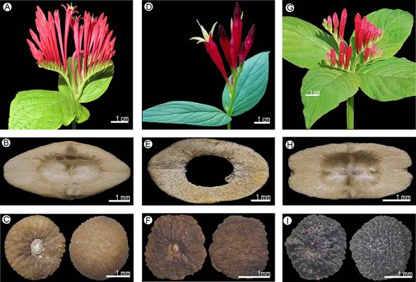
Figure 14: Morphological characters. Spigelia longiflora M. Martens & Galeotti: A. inflorescence (Naturalista, 2019b); B. carpoatlas; C. seed. Spigelia marilandica (L.) L.: D. inflorescence (Naturalista, 2020e); E. carpoatlas; F. seed. Spigelia mexicana A. DC.: G. inflorescence; H. carpoatlas; I. seed. Photographic credits: A) M.E. Mendiola (https://www.naturalista.mx/photos/44336379 CC BY-SA reproducida con autorización del autor); B), C), E), F), H), I): S. Islas; D) E. Keith (https://www.naturalista.mx/observations/44634963 CC BY-NC); G: R. Ramírez.
Distribution and habitat: endemic species of Mexico (Guanajuato, Hidalgo, Jalisco, Morelos, Puebla, Querétaro, San Luis Potosí, and Veracruz) (Fig. 15). It inhabits coniferous and Quercus forests, tropical deciduous forest, and scrub, and is registered between 1100 and 2900 m elevation.
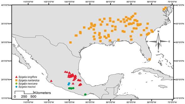
Figure 15: Distribution map of Spigelia longiflora M. Martens & Galeotti, Spigelia marilandica (L.) L., Spigelia mexicana A. DC., and Spigelia mocinoi S. Islas & L.O. Alvarado.
Conservation status: Least Concern (LC). This species has a wide distribution in several states of Mexico, covering an EOO: 164,387.90 km2 and AOO: 50,000 km2. Spigelia longiflora has been collected from numerous populations in recent years. Therefore, it is not considered under any type of threat.
Taxonomic remarks: Spigelia longiflora can be confused with S. speciosa, mainly because of the shape of the leaves. In collections, these species are often wrongly determined. However, they can be easily distinguished by the branched inflorescences (vs. solitary inflorescences) and corollas with red tube and lobes (vs. corollas with red tube and green-yellow lobes).
Specimens examined: MEXICO. Guanajuato, municipality Xichú, El Salto, 6.V.1991, E. Ventura 9191 (IEB, MEXU, XAL). Hidalgo, municipality Huejutla de Reyes, Pahuatlán, J. Salazar 5 (MEXU). Municipality Jacala de Ledezma, Jacala, 1.VII.1936, E. Lyonnet 1301 (IEB, MEXU). Municipality Mineral del Chico, El Chico, 1.V.1945, I. Berlín 25 (ENCB); loc. cit., 1.I.1910, IMN 5 (MEXU); La Carbonera, 1.VII.2027, E. Berthris 99 (MEXU); loc. cit., 1.VII.1927, E. Lyonnet 99 (IEB); Santa Virginia, El Chico, 10.IX.1950, M. Contreras 6 (MEXU); Cebadas, 17.V.1978, P. Lamy 222 (IMSS, MEXU); Las Tinajas, El Chico, 14.VI.1965, X. Madrigal 1476 (MEXU); alrededores de El Chico, 14.VII.1977, M. Medina 2090 (IBUG, MEXU); 2 km al NE de Carboneras, 19.VIII.1979, J. Rzedowski 36318 (ENCB, XAL); Parque Nacional El Chico, carretera vieja a El Chico, arriba de la Peña del Cuervo, 5.VII.1977, H. Sánchez 2776 (MEXU); Ejido de Pueblo Nuevo, Ranchería Morelos, 3.VI.1982, M. A. Villavicencio s.n. (FCME). Municipality Tianguistengo, 5 km al O de Tianguistengo, 21.XII.1981, R. Hernández 6902 (MEXU). Municipality Tlanchinol, Tlanchinol, aprox. 5 km al E, 27.IV.1997, O. Alcántara 3153 (FCME); camino entre Olotla y Tlamamala, 8.IV.1992, I. Luna 298 (FCME). Municipality Zacualtipán de Ángeles, Tlatoxca se localiza a 7 km al SE de la Ciudad Zacualtipán, 9.VII.1992, J. L. López 146 (MEXU); Zacualtipan, 27.III.1944, F. Miranda 3260 (MEXU), 3280 (MEXU). Jalisco, municipality Autlán de Navarro, 2 km al NW estación microondas, camino a Los Mazos carretera Autlán de Navarro - Barra de Navidad, 31.VII.1994, V. Santos 81 (INEGI). Morelos, municipality Tepoztlán, Cerro El Tepozteco, L. Hernández 3993 (MEXU, QMEX). Puebla, municipality Cuautempan, 1 km al W de Ixtolco, brecha de Tetela, 30.VI.1987, G. Toriz 547 (MEXU). Municipality Nicolás Bravo, autopista 150, entre Acultzingo y Azumbilla, 3-4 km de la línea del estado de Veracruz, 15.VII.1991, A. Mayfield 951 (MEXU, TEX). Municipality Tepetzintla, Cerro Chiquinahuimazatl, al W de Tepetzintla, A. Campos 498 (MEXU); loc. cit., 1.VII.1987, P. Tenorio 13853 (MEXU, UAMIZ). Municipality Teziutlán, en el camino de Teziutlán al Aire Libre, 12.VII.1953, D. Gold 306 (MEXU); cerca de Atexcaco, 13.VII.1953, D. Gold 291 (MEXU). Querétaro, municipality Arroyo Seco, alrededor de la boca del Sótano "El Barro" Santa María de Cocos, 27.IX.1997, J. Treviño 639 (QMEX). Municipality Cadereyta de Montes, Maconí - Ranchería La Luz, 24.IX.1998, R. Hernández 11644 (MEXU, QMEX). Municipality Ezequiel Montes, ladera N de Peña de Bernal, 23.VIII.1988, H. Díaz Barriga 4941 (IEB). Municipality Jalpan de Serra, Cañada de las Avispas, 15 km al SE de San Juan de los Durán, 28.VI.1989, R. Fernández 4578 (ENCB); 8-10 km al poniente de La Parada, Olla del Tecolote, 18.V.1990, B. Servín 221 (CIIDIR, IEB, MEXU, QMEX, XAL); 4-5 km al S y O de San Juan de los Durán, Cañada Las Avispas, 17.VII.1991, B. Servín 1182 (IEB, QMEX, TEX). Municipality Landa de Matamoros, Rincón de El Lobo, 18.VII.1988, E. González 26 (ENCB, IEB); Puerto de los Cajones, ±3 km al O de La Yesca, 15.V.1989, E. González 582 (ENCB, IEB, QMEX); km 229 de la carretera federal 120 a Xilitla, entre La Vuelta y el Madroño, 8.VII.2000, E. M. Lira 1406 (INEGI, MEXU); al NE de la Lagunita de San Diego, 2.VIII.2000, G. Campo 897 (IEB, MEXU); 7 km por la brecha a Tres Lagunas y Valle de Guadalupe, 2.VII.1987, H. Díaz Barriga 3865 (IEB, MEXU, QMEX); 1 km al SW de El Lobo, 1.VIII.1987, R. Fernández 4114 (ENCB); loc. cit., 1.VIII.1987, J. Rzedowski 44074 (ENCB, IBUG, IEB); Rincón de Peña Blanca, 12.IX.1988, H. Rubio 133 (IEB, MEXU, QMEX, XAL); El Banco, 1.5 km al SE de La Yesca, 17.IV.1989, H. Rubio 574 (CIIDIR, IBUG, IEB, MEXU, QMEX); 25.VII.1989, H. Rubio 917 (IEB, MEXU); 1.5 km al Poniente de El Puerto Hondo, 16.V.1990, H. Rubio 1659 (IEB, MEXU, QMEX); loc. cit., 1.VIII.1991, H. Rubio 2514 (IEB, MEXU, QMEX, XAL); 2 km al NO de Santa Inés, H. Rubio 1737 (IEB, QMEX); 8 km al W de El Lobo, 31.VIII.1957, J. Rzedowski 9308 (IEB); 5 km al W de El Lobo, sobre el camino a Landa, 26.VII.1959, J. Rzedowski 10916 (ENCB); 10 km al NE de El Madroño, sobre camino a Tres Lagunas, 1.VIII.1987, J. Rzedowski 44080 (CIIDIR, ENCB, IBUG, IEB); cerca de Tres Lagunas, 22.VII.1988, J. Rzedowski 46721 (IEB, MEXU); Joya del Hielo y alrededores, 17.VIII.1996, S. Zamudio 9922 (IEB, MEXU, QMEX, XAL). Municipality Pinal de Amoles, 1 km al NE de El Llano, 30.VI.1988, E. Carranza 674 (IEB, MEXU); Chuveje, 4.VIII.1998, B. Córdova 661 (CIIDIR); El Llano, 15.VI.1986, N. B. Medina 206 (IEB, MEXU, TEX). Municipality San Joaquín, brecha hacia San Juan Tetla, 25.X.1994, R. Hernández 10942 (QMEX). San Luis Potosí, municipality Río Verde, El Aguijón, 28 km al SSW de Río Verde, 8.VI.1956, J. Rzedowski 7689 (CIIDIR, IBUG, IEB, MEXU, OAX). Municipality San Luis Potosí, ±8 km al W de El Lobo, 31.VIII.1957, J. Rzedowski 9308 (MEXU). Municipality Zaragoza, Sierra de Álvarez, Las Ruinas, 17.VII.2015, P. Castillo 1001 (FCME). Veracruz, municipality Acultzingo, La Barranca del Tule, 7.VIII.1978, F. Ventura 15436 (IEB, MEXU, OAX, XAL). Municipality Ciudad Mendoza, 3 km al N de Ciudad Mendoza, Cerro Palo Verde, 3.VIII.1996, H. Oliva s.n. (IBUG). Municipality Huayacocotla, Potrero Seco, 17.II.1980, L. Ballesteros 226 (MEXU, XAL); Helechales, 29.VI.1984, R. Ortega 2673 (XAL); entre Helechales y Los Ocotes, 6.VII.1980, Y. A. Vargas 343 (MEXU). Municipality Maltrata, Maltrata, 1.V.1937, E. Matuda 1302 (MEXU).
Spigelia marilandica (L.) L., Syst. Nat., ed. 12. 2: 734. 1767.
TYPE: UNITED STATES OF AMERICA. Virginia, s.d., J. Clayton s.n. (lectotype: BM-98044!, lectotype designated by Reveal and Jarvis (2009)).
≡ Lonicera marilandica L., Sp. Pl. 1: 175. 1753, nom. superfl.
= Spigelia lonicera Mill., Gard. Dict. (ed. 8) Spigelia no. 2. 1768.
= Spigelia marilandica forma eburnea Van Horn & Freeman, Sida 11: 248. 1985. TYPE: UNITED STATES OF AMERICA. Tennessee, Hamilton Co., Chattanooga, growing among oaks, hickories and dogwoods in lot adjacent to 3116 Lockwood Drive, 260 m, 19.V.1982, J. R. Freeman 1 (holotype: NCU-0593!).
Herbs branched, stem quadrangular, glabrous, without lignification; leaves opposite below the inflorescence, sessile, lamina ovate-lanceolate, membranaceous, 6-10 cm long; stipules present, linear; inflorescence terminal, scorpioid cyme, 3-12 flowers, sessile (Fig. 14D); sepals green with purple apex, lanceolate; corolla infundibuliform, 5.5-6 cm long, tube and lobes red, lobes lanceolate; stamens inserted above the middle part of the corolla tube, exserted, filaments present; pollen not seen; stigma capitate, style pubescent; capsule glabrous, 7-8 mm diameter, metastyle present, longer than the capsule, carpoatlas elliptic (Fig. 14E), transversal ridge present; seeds 8, ovate, testa reticulate (Fig. 14F).
Distribution and habitat: endemic species to the United States of America (Alabama, Arkansas, Florida, Georgia, Kentucky, Louisiana, Maryland, Mississippi, Missouri, Oklahoma, South Carolina, Tennessee, and Texas) (Fig. 15). It inhabits the margins of forests (Gould, 1997) between 50 and 730 m elevation.
Conservation status: Least Concern (LC). Spigelia marilandica is one of the endemic species of the genus in the United States of America with the largest distribution, covering an EOO: 1,878,570.83 km2 and AOO: 200,000.00 km2, as well as the most collected species of Spigelia in the country. Therefore, it is considered in the Least Concern category.
Taxonomic remarks: Spigelia marilandica is similar to S. speciosa in floral characters, because of the species distributed in the NA region; they are the only ones with corollas of red tubes and yellow petal lobes. However, these can be distinguished by green sepals with purple apex, capitate stigma and straight petal lobes in S. marilandica, vs. entirely green sepals, terete stigma with pubescent style and reflexed petal lobes in S. speciosa. Likewise, the disjunct distribution of both species allows us to identify them as different taxa.
Specimens examined: UNITED STATES OF AMERICA. Alabama, county Chilton, Clanton, 21.VII.1990, C. L. Pollard 267 (US). County Jefferson, Birmingham, 18.IX.1884, S. B. Bucley s.n. (MEX). County Madison, US 431 ca. 1.5 mi SE entrance Monte Sano State Park, 3.VII.2002, R. Kral 92807 (US). County Mobile, Mobile, 1.VI.1866, C. Mohr s.n. (US). Arkansas, county Chicot, woods along north side of Indian Creek west of Aek, 159 south of Indian and south of Eudora; Sec. 2, 27.V.2000. R. D. Thomas 166040 (TEX). County Cleburne, moist bottoms, P.O. Tumbling Shaols, 19.V.1951, D. Demaree 30478 (MEX, TEX). County Fort Smith, Lieut. A.W. Whipple's Exploration for a Railway Route, from the Mississippi River to the Pacific Ocean, near the 35th parallel of Latitude in 1853-4, 1.I.1853, J. M. Bigelow s.n. (US). County Lee, rich low woods by US 79, ca. 8 mi W of Mariana, 17.V.1978, R. Kral 61820 (TEX). County Marion, Buffalo River State Park & vicinity, 19.V.2006, D. M. Moore s.n. (TEX). County Polk, Bard Springs, ca. 25 mi E of Vandervoort, Ouachita National Forest, 21.V.1981, L. J. Dorr 1922 (TEX); along FS rd 14030 and 176 between Caney Creek Wilderness and Bee Mt. Lookout, E of Mena in Ouachita Nat. Forest, 25.V.1999, R. Kral 88587 (TEX). County Pulaski, Little Rock, 18.V.1886, H. E. Hasse 1886 (US); along Nature Trail between Burns Park Golf Course and Arkansas River, 24.V.1983, J. Kessler 7096 (TEX). County Sharp, Hardy, 15.V.1949, D. Demaree 27736 (TEX). Florida, county Jacksonville, Three Rivers State Park, cultivated in U.T. Austin greenhouses, 5.VIII.1997, K. Gould 163 (TEX). County Miami-Dade, N.S. side Homestead, 19.IX.1973, R. Kral 51823 (TEX). Georgia, county Burke, above Savannah R., 6.V.1970, L. Ellison 1003 (MEX, TEX). County Chatham, Savannah, 1.V.1869, W. M. Canby s.n. (US). County Clay, geological Formation: Archaean, 14.VII.1900, R. M. Harper 234 (US); rich woods, ravine, 1/2-mile soth of Fort Gaines, 6.V.1947, R. Thorne 3710 (US). County Dade, canyon, E of Trenton, Geol. Prov. Cumberland, 8.V.1948, A. Cronquist 5131 (US); rocky stream bed on Running Creek 4 mi S of Tennessee line, 6.VI.1942, W. Duncan 5395 (TEX). County DeKalb, woods near East Lake, Geological formation: Archaean, 9.VII.1900, P. Wilson 50 (US). County Gwinnet, Thompsons Mills and vicinity, 14.V.1908, H. A. Allard 190 (US); 24.V.1908, H. A. Allard 191 (US); loc. cit., 17.V.1908, H. A. Allard 192 (US). County Meriwether, Warm Springs, 19.V.1905, M. Tracy 9233 (TEX, US). County Stephens, Toccoa, 29.V.1916, J. L. Peters 8 (US). County Walker, the southern Appalachian Region, Lookout Mt., 1.IV.1898, A. Ruth 461 (US). County Walton, N end of Alcovy Mt, near base, 5 mi S of Monroe, Geol. Prov. Piedmont, 16.V.1948, A. Cronquist 5199 (US). County Wilcox, upper Seven Bluffs of Ocmulgee River, Lower Oligocene Region of the Coastal Plain, 17.V.1904, R. M. Harper 2209 (US). Kentucky, county Allen, five miles southwest of Scottsville, 8.VI.1945, F. T. McFarland 94 (US). County Estill, Irvine, 19.VI.1923, W. A. Anderson 43 (US). County Perlaski, Perlaski, 22.VI.1878, B. W. Evermann s.n. (US). County Wayne, Cooper rd, 19.VI.1935, E. L. Braun 1044 (US); Beaver Creek, southwest of Monticello, 12.VII.1937, L. B. Smith 3896 (US). Louisiana, county Acadian, woods around church east of La. 13, 11.4 mi south of Eunice, Sec. 32, 8S, R1E, 15.V.1980, A. Rich 1886 (MEX). County Covington, vicinity of Covington, 13.VII.1920, G. Arsène 12406 (US). County Lincoln, 4 mi S of Ruston, 9.V.1951, J. A. Moore s.n. (TEX, US). County Pineville, Camp Beauregard, Alexandria, Rapides Parish, 23.VI.1918, E. C. Leonard 1561 (US). County Rapides, mesic hardwood slopes forest, NEQ, SWQ, Sec. 28, T3N, R2W, along Castor Plunge Rd., ca. 0.1 mi SE of int. FS Rd. 277, near bottomland of Loving Creek, ca. 6 mi NW od Woodworth, West 7.5' Quad., Kisatchie National Forest, 27.V.1988, S. Orzell 7070 (TEX). County Shreveport, Shreveport, 18.IV.1930, H. C. Benke 5539 (US). County Winn, Kisatchie Nat. Forest, Winn Disct., Compt. 44 Stand 8 W of WO44B and W=44K just east of Little Creek, south of La. 1232, Sec. 36, TI2N, R4W, 20.V.1997, R. D. Thomas 154053 (TEX). Maryland, county Baltimore, G. McCarthy s.n. (TEX). Mississippi, county Amite, upland hardwood forest in ravines of the Gladner Srboretum in Gloster, 12.V.1981, J. Pruski 2106 (TEX, US). County Attala, Riche’s glades in pine and oak barrens west Kosciusko, 17.V.1933, C. A. Weatherby 6299 (US). County Copiah, Wooded hills, 7 miles west of Crystal Springs, 27.VI.1925, F. A. Cook s.n. (US). County Lafayette, Oxford, 1.I.1870, E. A. Smith s.n. (US). County Lincoln, Brookhaven, 14.IV.1882, M. B. Flint 128 (US). County Madison, Natchez Trace Parkway, 12.V.1947, W. B. McDougall 1298 (US). County Natchez, vicinity of Natchez, 1.V.1848, J. Blake s.n. (US). County Oktibbeha, Starkville, 14.V.1895, S. M. Tracy 1354 (US). Missouri, county Dunklin, Campbell, 7.VIII.1910, B. F. Bush 6372 (US). County Holcomb, Pleasant Grove, 13.VIII.1899, B. F. Bush 280 (US), Bush 354 (US). Oklahoma, county Durant, W. L. Blain 125 (US). County Le Flore, Near Page, 20.VI.1914, O. W. Blakley 1430 (US); Poteau, 13.VII.1915, E. J. Palmer 8274 (US). County McCurtain, Broken Bow, 16.V.1936, D. Demaree 12647 (US). South Carolina, county Beaufort, Bluffton, 1.I.1884, J. H. Mellichamp 413 (US); Beaufort, 1.I.1883, J. H. Mellichamp 1170 (US). County Berkeley, Monks Corner, 1.VII.1879, M. E. Hyams s.n. (US). County Charleston, Porchers Bluff, Christ church Parish, 13.V.1911, E. A. Mearns 37 (US). County Columbia, United States Botanical Garden, 100 Maryland ave. SW, 30.VII.2015, K. M. Van Neste 720 (US). County Oconee, Fort Hill, 13.V.1906, H. D. House 2139 (US); Seneca, 1.VI.1888, G. M. McCarthy s.n. (US). County Pickens, along US 176, 1.1 miles north of juct. of old SC 11, 29.V.1971, S. Leonard 4865 (MEX, TEX); table Rock-South foot, 1.VI.1942, L. Rodgers 563 (TEX). County Williamsburg, 15 miles southwest of Gourdin, 10.VII.1939, R. K. Godfrey 455 (US). Tennessee, county Benton, Camden, 31.V.1932, J. R. Swallen 2037 (US). County Davidson, Nashville-Domness Hill, 6.V.1945, S. Batson 23 (TEX). County Gatlinburg, Great Smoky Park, near Gatlinsburg, 1.I.1932, C. D. Walcott s.n. (US); Great Smoky Mts., 18.VI.1931, E. H. Walker 1506 (US). County Hamilton, near Chattanooga, 30.V.1911, J. R. Churchill s.n. (US); swamp behind Tennessee Welcome Center. I-75, 16.V.1999, V. E. McNeilus s.n. (MEX). County Haywood, low exposed area at Hatchie WMA, about 4 miles south of Brownsville, V. E. McNeilus s.n. (MEX, TEX). County Jackson, steep, mesic slope along Big Bottom Road, about 3 mi north of Gainsboro, V. E. McNeilus s.n. (MEX). County Knox, Lovell, Quad. P 1980 rich woods off Farlow Drive deadend 0.5 mi S of Kingston Pike, 25.V.1993, P. Mowery s.n. (MEX). County Knoxville, Knoxville, 20.V.1890, F. Lamson-Scribner s.n. (US). County Lewis, south of Gordonsburg along lower part of Black Branch, a tributary of Little Swan Creek, 30.V.1990, A. Mayfield 546 (TEX). County Nashville, woods about Nashville, 1.VI.1879, A. Gattinger 2260 (US). County Overton, mesic roadside along Sunk Cane Road, about 3 miles west of Rt. 164, 31.V.1994, V. E. McNeilus s.n. (MEX). County Polk, McFarland Quadrangle, along rock wall beside railroad tracks approx. 1 mi below Appalachia powerhouse, 25.VI.1993, T. Calfee s.n. (TEX). Texas, county Bowie, About 2 miles north of Texarkana, 12.VII.1965, D. S. Correll 18856 (TEX); 24.V.1958, D. S. Correll 31262 (TEX). County Jasper, 3 miles south of Holly Springs, 29.IV.1967, J. R. Crutchfield 2571 (TEX). County Red River, 4 miles E of Bogotá on FR 909, 15.V.2001, W. C. Holmes 11472 (TEX). County Sabine, 3 mi S of Milam, rich wooded hills above small stream, 21.V.1947, R. McVaugh 8414 (TEX). County San Agustine, 7 mi east of San Agustine, east of Apollo-Gocho stream Cousin's Farm, Black Ankle Community, 14.X.1962, D. S. Correll 26278 (TEX); Forest along Palo Gaucho Bayou, about 7 mi east of San Agustine, 10.V.1969, D. S. Correll 37208 (TEX); hwy. 3153, E of San Agustine; forest just E of Palo Gaucho Bayou, S side of rd., 9.V.1993, K. Gould 1 (TEX). County Tarrant, Woods, near Fort Worth, 4.V.1909, A. Ruits s.n. (TEX).
Spigelia mexicana A. DC., Prodr. 9: 7. 1845.
TYPE: MEXICO. s.l., s.d., J. A. Pavón s.n. (lectotype: G-00368297!, designated by McVaugh, Bot. Results Sessé & Moc. Exped. 7: 351 (2000)).
Herbs not branched, stem quadrangular, glabrous, without lignification; leaves pseudowhorled below the inflorescence, sessile, lamina ovate-elliptic, membranaceous, 4.9-12 cm long; stipule present, linear; inflorescence axillary, scorpioid cyme, 4-6 flowers, pedicellate (Fig. 14G); sepals green, triangular; corolla tubular, 2-3.8 cm long, tube and lobes red, lobes ovate; stamens inserted above the middle part of the corolla tube, included, filaments present; pollen in monads, oblate, with medium polar area, 3 simple apertures, without margo on the colpi; stigma capitate, style glabrous; capsule glabrous, 6.5-9 mm diameter, metastyle present, longer than the capsule, carpoatlas oblong (Fig. 14H), transversal ridge present; seeds trulate-ovoid, testa foveolate (Fig. 14I).
Distribution and habitat: endemic species of Mexico (states Guerrero, Oaxaca, and Puebla; Fig. 15). It lives in tropical deciduous and sub-deciduous forest, and is found from 1000 to 2500 m elevation.
Conservation status: Least Concern (LC). This species is distributed in an area of occupation of 11,000.00 km2 (EOO: 74,350.48 km2), in Mexico. Although six populations are known, and the GeoCAT analysis places it in the Least Concern (LC) category, the species has not been collected in over 15 years. This is mainly due to the fact that they are found in areas of difficult access, where the populations could currently remain stable.
Taxonomic remarks: this species is morphologically similar to S. splendens Hook, by the shape of the leaves and shape and color of the corollas, in addition to having a sympatric distribution. Spigelia mexicana can be distinguished by the sessile leaves (vs. petiolate leaves in S. splendens), axillary inflorescences with fewer flowers (vs. always terminal inflorescences, with greater number of flowers).
Specimens examined: MEXICO. Guerrero, municipality Ahuacotzingo, aprox. 12 km al S de Ajuatetla, carr. Ajuatetla - Chilapa, 19.VI.1986, M. Martínez 56 (FCME, HUAP, MEXU). Municipality Chilpancingo de los Bravo, Chilpancingo, 8km al N, carretera a Iguala, 8.VII.2000, R. Cruz-Durán 4764 (FCME, MEXU). Municipality Eduardo Neri, El Palmar, 2 km al N, 24.VI.1995, J. Jiménez 1136 (FCME, MEXU). Municipality Minatitlán, arroyo Mesa Queisle, 7.XI.1937, G. B. Hinton 10487 (TEX). Oaxaca, municipality San Miguel del Puerto, panteón, 16.V.2000, F. López 161 (IEB).
Spigelia mocinoi S. Islas & L.O. Alvarado, Phytotaxa 331(2): 247. 2017.
TYPE: MEXICO. Estado de México, Ixtapan de la Sal, Temascaltepec, 18.VII.1935, G. B. Hinton 8063 (holotype: MEXU-102425!, isotype: ENCB!, HUMO!).
= Bouvardia amplexicaulis Borhidi & E. Martínez, Acta Bot. Hung. 53(1-2): 64. 2011, non Spigelia amplexicaulis E.F. Guim. & Fontella (1969). TYPE: MEXICO. Estado de México, Santiago Amatepec, ladera húmeda, rocosa, barranca, 1300 m, 13.VII.1970, E. Matuda 38039 (holotype: MEXU133854!).
Herbs not branched, stem cylindrical, pubescent, without lignification; leaves opposite below the inflorescence, sessile, lamina ovate-lanceolate, membranaceous, 2.9-3.3 cm long; stipule absent; inflorescence terminal, scorpioid cyme, 3-5 flowers, pedicellate (Fig. 16-A); sepals green, linear; corolla hypocrateriform, 10 cm long, tube and lobes white, lobes elliptic; stamens inserted above the middle part of the corolla tube, included, filaments present; pollen in monads, oblate, with medium polar area, 3 simple apertures, without margo on the colpi; stigma capitate, style pubescent; capsule not seen; seeds not seen.

Figure 16: Morphological characters. Spigelia mocinoi S. Islas & L.O. Alvarado: A. inflorescence. Spigelia polystachya Klotzsch ex Progel: B. inflorescence; C. carpoatlas; D. seed. Spigelia pygmaea D.N. Gibson: E. inflorescence; F. carpoatlas; G. seed. Photographic credits: A-G): S. Islas.
Distribution and habitat: endemic to Mexico (Mexico State) (Fig. 15), growing in tropical deciduous forest; is registered between 1000 and 1300 m elevation.
Conservation status: Endangered (EN). This species is known from three specimens collected more than 50 years ago, so the category of Endangered is suggested (EOO: 1.07 km2, AOO: 55.00 km2).
Taxonomic remarks: this species is morphologically similar to S. nicotianiiflora Chodat & Hassl. Spigelia mocinoi is distinguished by being non-rhizomatous plants (vs. rhizomatous plants), and has inflorescences with 3-5 flowers (vs. 8-9 flowers) and corolla lobes 1.9-2 × 1 cm (vs. 0.9-1.6 × 0.4-0.5 cm). Another important attribute that shows the differences between both taxa is the pollen grains, mainly in size and type of ornamentation. Spigelia mocinoi presents a more complex sculpture, with rugulae, gems and verrucae ornamentation concentrated in the apocolpium and only rugulae in the mesocolpium, while S. nicotianiiflora presents homogeneous rugulae in both the apocolpium and the mesocolpium. Likewise, the distribution of S. mocinoi and S. nicotianiiflora is contrasting, being the first endemic to Mexico and the other endemic to Paraguay; therefore, there are numerous geographic barriers that restrict the distribution area of each species.
Specimens examined: MEXICO. Estado de México, municipality Temascaltepec de González, Ixtapan, 8.II.1933, H. Kruse 4469 (TEX, US).
Spigelia polystachya Klotzsch ex Progel, Fl. Bras. 6(1): 265. 1868.
TYPE: GUYANA. Guyana britanicae regione, 1840, R. H. Schomburgk 412 (holotype: G, isotypes: F, B-003914!).
≡ Pseudospigelia polystachya (Klotzsch ex M.R. Schomb) W. Klett, Bot. Arch. 3: 136 (1923).
Herbs not branched, stem quadrangular, glabrous, without lignification; leaves opposite below the inflorescence, sessile, lamina linear, papyraceous, 2-5 cm long; stipules present, deltate; inflorescence axilar, scorpioid cyme, 6-19 flowers, pedicellate (Fig. 16B); sepals green, deltate; corolla campanulate, 1.5-3 cm long, tube and lobes white, lobes ovate; stamens inserted in the middle part of the corolla tube, included, filaments absent; pollen in monads, suboblate, with medium polar area, 3 simple apertures, with margo on the colpi; stigma terete, style pubescent; capsule glabrous, 2-2.7 mm diameter, metastyle absent, carpoatlas quadrangular (Fig. 16C), transversal ridge absent; seeds ovate-compressed, testa rugose (Fig. 16D).
Distribution and hábitat: distributed in Mexico (Campeche, Tabasco, and Veracruz), Belize (Belize), Guatemala (Petén), Honduras (Fernández-Casas and Huft, 2009), and El Salvador (Fig. 17); Fernández-Casas and Huft, 2009). Outside the study area, it occurs in Venezuela, Guyana, and Brazil (Fernández-Casas and Huft, 2009). It inhabits thorny forest, humid tropical forest, and grasslands, and is recorded between 10 and 250 m elevation.
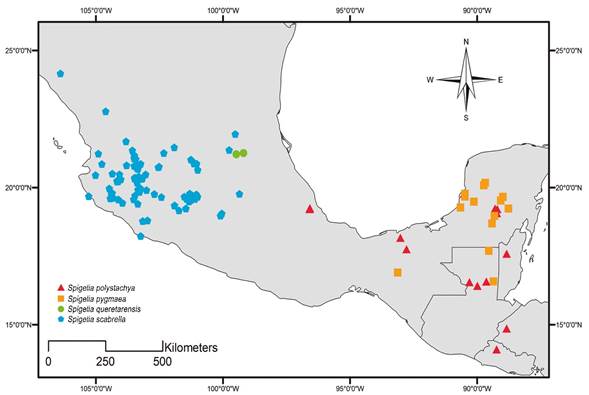
Figure 17: Distribution map of Spigelia polystachya Klotzsch ex Progel, Spigelia pygmaea D.N. Gibson, Spigelia queretarensis Fern. Casas, and Spigelia scabrella Benth.
Conservation status: Least Concern (LC). Spigelia polystachya is widely distributed in southern Mexico and in several Central American countries, covering an EOO: 152,327.91 km2 and AOO: 25,000.00 km2. Likewise, the species has been collected from abundant populations in recent years, so it is not considered endangered.
Taxonomic remarks: Spigelia polystachya is one of the smallest plants in the genus, along with S. pygmaea D.N. Gibson and S. queretarensis Fern. Casas. It is distinguished from S. pygmaea by its smaller, lanceolate (vs. ovate), opposite leaves below the inflorescence (vs. pseudowhorled leaves below the inflorescence), and smooth capsules (vs. apically papillose capsules). From S. queretarensis it is distinguished by the shape of the leaves, papyraceous (vs. oblong, membranous leaves), inflorescences with up to 19 flowers (vs. monochasium with 1-3 flowers), campanulate corolla (vs. hypocrateriform), as well as capsule metastyle absent (vs. metastyle 2-3 mm long). In herbaria, this species has been confused with S. anthelmia. This may be due to the lanceolate shape of the leaves, but they can be easily distinguished by the size of the plant and the ornamentation of the capsules.
Specimens examined: BELIZE. Department Belize, Crooked Tree, western shore of Northern Laggon, 22.III.1987, G. Davidse 33120 (US). GUATEMALA. Department Petén, municipality Cedral, along Río San Martín, between Cerro Cedral and Ceibal, 29.IV.1942, J. A. Steyermark 46024 (TEX, US); 46148 (TEX, US). Municipality Sayaxché, Río Pasión, Laguna San Juan Acul, in tintal bordering the lake, 12.III.1964, C. L. Lundell 18220 (TEX). MEXICO. Campeche, municipality Campeche, 2 km al NE de Chiná, 8.VIII.1998, C. Gutiérrez 5901 (CICY, MEXU, UAMIZ, XAL). Municipality Hopelchén, a 4.3 km al NO de Chan-chen, 11.VI.2004, D. Álvarez 8880 (MEXU); 9.8 km al SSE de Pachuitz, 14.VI.2004, D. Álvarez 9106 (MEXU); 9.03 km al S de Pachuitz, 4.VIII.2004, D. Álvarez 10252 (MEXU), D. Álvarez 10260 (MEXU); 7.16 km al S de Pachuitz, 4.VIII.2004, D. Álvarez 10307 (IBUG, MEXU). Tabasco, municipality Centro, Rancho Dos Montes, km 12 carr Villahermosa - Escarcega, atrás del aeropuerto Villahermosa, 26.X.1988, A. Sol 174 (MEXU). Municipality Nacajuca, Camellones Chintales de Tucta, cerca de Nacajuca, 17.VII.1979, C. Cowan 2366 (ENCB, XAL). Veracruz, municipality Paso de Ovejas, Acazónica, 15.XII.1980, F. Ventura 18063 (IEB). Municipality Puente Nacional, La Ceiba, 1.X.1973, F. Ventura 9061 (MEXU, XAL); loc. cit., 29.I.1975, F. Ventura 10876 (ENCB).
Spigelia pygmaea D.N. Gibson, Fieldiana, Bot. 32: 5. 1968.
TYPE: GUATEMALA. Petén, in savanna ca. 7 km W of village in zapotal, on La Gloria road, Dos Lagunas, 19.X.1960, E. Contreras 1537 (holotype: LL-256903!, isotype: F-1652726!).
Herbs not branched, stem quadrangular, glabrous, without lignification; leaves pseudowhorled below the inflorescence, petiolate, lamina ovate, membranaceous, 6 cm long; stipules present, deltate; inflorescence terminal, scorpioid cyme, 10-15 flowers, pedicellate (Fig. 16E); sepals green with purple margin, deltate; corolla campanulate, 1-3 cm long, tube and lobes white, lobes deltate; stamens inserted at the middle part of the corolla tube, included, filaments absent; pollen in monads, suboblate, with large polar area, 3 simple apertures, with margo on the colpi; stigma capitate, style pubescent; capsule pubescent, 1.8-2.5 mm diameter, metastyle absent, carpoatlas oblong (Fig. 16F), transversal ridge absent; seeds quadrangular-compress, testa rugose (Fig. 16G).
Distribution and habitat: species distributed in Mexico (Campeche, Chiapas, Quintana Roo, and Yucatán) and Guatemala (Petén) (Fig. 17). It grows in tropical deciduous and sub-deciduous forest, and is found between 50 and 850 m elevation.
Conservation status: Least Concern (LC). Spigelia pygmaea is distributed in an area of about 106,486.46 km2 of EOO, and 30,000.00 km2 of AOO in Mexico and Guatemala. Several abundant populations are known in the different states, and it has been collected regularly in recent years. Therefore, it is not considered under any category of threat.
Taxonomic remarks: the individuals of this species are easily recognizable for being small plants, less than 10 cm tall, like S. polystachya and S. queretarensis. It presents apically papillose capsules and can therefore be related to S. anthelmia (Gould, 1997), in addition to presenting pseudowhorled leaves below the inflorescence. However, it is distinguished from the latter by the ovate shape of the leaves (vs. lanceolate leaves), smaller, as well as the carpoatlas with rounded margins (vs. margins with acuminate tips).
Specimens examined: GUATEMALA. Department Petén, municipality Dolores, Dos Lagunas, on La Gloria Road, about 7 km W of the village, Dos Lagunas, 19.X.1960, E. Contreras 1537 (TEX); Dolores, about 3 km NWW of village, 18.X.1961, E. Contreras 3071 (TEX). MEXICO. Campeche, municipality Calakmul, a 10.8 km al N de Zoholaguna, 3.X.2003, D. Álvarez 6699 (MEXU). Municipality Campeche, 2 km al Este de Chiná, 1.XI.2004, C. Gutiérrez 8355 (CICY); 2 km al SO de Mucuychakán, 18.IX.2005, C. Gutiérrez 8720 (MEXU, XAL), C. Gutiérrez 8723 (CICY, MEXU, XAL). Municipality Champotón, quebrada unos 2 km antes del desvío a Ulumal y El Zapotal, 24.X.1997, G. Carnevali 4672 (CICY, MEXU). Municipality Hopelchén, 11 km al S de la Frontera Yucatán - Campeche, ca. de San Antonio Yax-ché, 20.IX.1999, G. Carnevali 5663 (CICY, MEXU, XAL); Aguada, a 4.8 km al ENE de Bel-ha, 27.VIII.2005, E. Martínez 38272 (MEXU). Chiapas, municipality San Fernando, Mirador de Chicoasen Dam, a lo largo del camino de Tuxtla Gutiérrez a Chicoasen Dam, 9.IX.1976, D. E. Breedlove 39969 (MEXU). Quintana Roo, municipality José María Morelos, a 4.7 km al S de Venustiano Carranza, 22.VI.2004, D. Álvarez 9682 (MEXU); a 4.7 km al S de Venustiano Carranza, 22.VI.2004, D. Álvarez 10389 (MEXU); a 2.71 km al SE de Sabana San Francisco, 3.IX.2004, D. Álvarez 10501 (IBUG, MEXU); a 4.6 km al NE de Othón P, Blanco, camino a San Carlos, 18.VIII.2005, E. Martínez 38083 (MEXU). Municipality Othón P. Blanco, 3-4 km al O de Margarita Maza, unos 11 km al O de Graciano Sánchez (La Patera), 25.VIII.1999, G. Carnevali 5590 (CICY, MEXU). Yucatán, municipality Santa Elena, Ruta Puc, Zona Arqueológica Sayal, a lo largo de la carretera Uxmal - Oxkutzcab, 19.VIII.2001, G. Carnevali 6408 (CICY).
Spigelia queretarensis Fern. Casas, Fontqueria 55(65): 528. 2008.
TYPE: MEXICO. Querétaro, La Parada, ca. 3 km al S, 20.VIII.1988, E. Carranza 809 (holotype: IEB-198324!).
Herbs not branched, stem quadrangular, glabrous, without lignification; leaves opposite below the inflorescence, sessile, lamina oblong, membranaceous, 2.3 cm long; stipules present, deltate; inflorescence terminal, monochasium cyme, 1-3 flowers, pedicellate (Fig. 18A); sepals green, linear; corolla infundibuliform, 1.5-2.5 cm long, tube white with purple lines, lobes white with purple margin, lobes lanceolate; stamens inserted in the middle part of the corolla tube, filaments absent; pollen in monads, oblate-spheroidal, with medium polar area, 3 simple apertures, without margo on the colpi; stigma capitate, style glabrous; capsule glabrous, 5 mm diameter, metastyle present, longer than the capsule, carpoatlas oblong, transversal ridge absent; seeds semi-spheroidal, testa tuberculate (Fig. 18B).
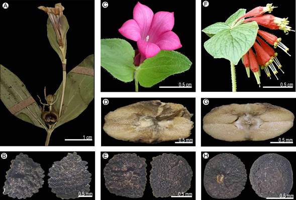
Figure 18: Morphological characters. Spigelia queretarensis Fern. Casas: A. inflorescence; B. seed. Spigelia scabrella Benth.: C. inflorescence (Naturalista, 2007); D. carpoatlas; E. seed. Spigelia speciosa Kunth: F. inflorescence; G. carpoatlas; H. seed. Photographic credits: A), B), D), E), G), H): S. Islas; C) I. Torres (https://www.naturalista.mx/observations/5595601 CC BY-NC); F) R. Fonseca.
Distribution and habitat: endemic species of Mexico (Querétaro) (Fig. 17). It lives in Quercus forest, and is found between 1200 and 1700 m elevation.
Conservation status: Critically Endangered (CR). This species is known from the type specimen and two populations collected in a nearby area. Due to the limited information, the species should be considered in a category of critical danger.
Taxonomic remarks: this species can be confused with S. polystachya due to the size of the plants, sessile leaves, all opposite, triangular stipules, and smooth capsules. They can be distinguished by oblong leaves (vs. lanceolate), inflorescences with 1-3 flowers (vs. 19), hypocrateriform corolla (vs. campanulate). In addition, Spigelia polystachya is widely distributed in Belize, Costa Rica, El Salvador, Guatemala, Honduras, Mexico, and Nicaragua, whereas S. queretarensis is restricted to the state of Querétaro in Mexico.
Specimens examined: MEXICO. Querétaro, municipality Landa de Matamoros, 8.5 km al SW de El Lobo, por la carretera a Jalpan, 29.VI.2010, S. Zamudio 14782 (IEB).
Spigelia scabrella Benth., Pl. Hartw. 45. 1840.
TYPE: MEXICO, s.l., s.d., 1837, K. T. Hartweg 346 (holotype: P-507551!).
Herbs not branched, stem quadrangular, pubescent, without lignification; leaves opposite below the inflorescence, sessile, lamina ovate, membranaceous, 2.1-4.3 cm long; stipules present, linear; inflorescence terminal, monochasium cyme, 1-3 flowers, pedicellate (Fig. 18C); sepals green, lanceolate; corolla infundibuliform, 4.5-6 cm long, tube and lobes purple, lobes ovate; stamens inserted at the middle part of the corolla tube, included, filaments present; pollen in monads, sub-oblate, with medium polar area, 3-4 simple apertures, without margo on the colpi; stigma capitate, style glabrous; capsule glabrous, 7-8 mm diameter, metastyle present, smaller than the capsule, carpoatlas oblong (Fig. 18D), transversal ridge present; seed ovate, testa reticulate (Fig. 18E).
Distribution and habitat: endemic to Mexico (Durango, Mexico State, Guanajuato, Jalisco, Michoacán, Nayarit, Querétaro, San Luis Potosí, Sinaloa, and Zacatecas) (Fig. 17). It lives in coniferous and Quercus forest, and is found between 1000 and 2500 m elevation.
Conservation status: Least Concern (LC). Spigelia scabrella is one of the species of the genus with the largest distribution area in the country with an EOO of 302,774.98 km2 and an AOO of 102,500.00 km2, in addition to being one of the most collected for its striking pink or purple flowers. Numerous abundant populations are known in different states of Mexico and have been collected repeatedly in recent years. Therefore, it is not considered under any type of threat.
Taxonomic remarks: this species is similar to S. guerrerensis due to the shape and size of the leaves, as well as the infundibuliform corolla. It can be distinguished by the purple corolla, glabrous style, and apically smooth capsules (vs. white corolla, pubescent style and apically papillosus capsules). In addition to presenting a wide distribution towards northwestern Mexico, while S. guerrerensis is restricted to the southwestern region of the country.
Specimens examined: MEXICO. Durango, municipality Mezquital, Candelarita El Chico, al NNW, vereda a Tachichila, 8.VIII.2015, J. G. González-Galegos 1874 (CIIDIR). Estado de México, municipality Tejupilco, prox. a Teneria, 19.VIII.1979, E. Guizar 610 (MEXU). Municipality Temascaltepec de González, Cerro Muñeca, G. B. Hinton 1380 (MEXU, TEX). Municipality Tepotzotlán, camino a Colonia Dolores, el camino está entre la carretera a Arcos del Sitio y San Juan de las Tablas, 21.VI.1979, F. J. Espinosa 644 (MEXU). Guanajuato, municipality Juventino Rosas, 47 km al de San Miguel Allende, hasta Gto. (pasando la Pera I. Allende), 1.VIII.1979, J. Kishler 707 (MEXU); 36 km al SE de Guanajuato, sobre la carretera a Juventino Rosas, 14.VII.1987, J. Rzedowski 43781 (CIIDIR, ENCB, IBUG, IEB); 23 km al NNW de Juventino Rosas, sobre la carretera a Guanajuato, J. Rzedowski 53592 (CIIDIR, IEB, MEXU, XAL). Jalisco, municipality Arandas, 1 km de El Mirador, 16.VII.1976, A. Delgado 266 (MEXU); brecha San Ignacio Cerro Gordo, antenas de microondas, 3.VII.1992, R. Ramírez 2793 (IBUG). Municipality Autlán de Navarro, 8.5 mi SSW de Autlán por la autopista Mex. 80, 14.VIII.1966, R. Kral 27646 (ENCB); Reserva de la Biosfera Sierra de Manantlán, 10 km al SW de Autlán, 13.VII.1992, A. Leinberger 67 (IBUG); Los Mazos, al W de Autlán, 10.IX.1989, R. Ramírez 1579 (IBUG, MEXU), 25.VII.1994, R. Ramírez 3314 (IBUG); km 4, brecha Ahuacapán - Corralitos, 27.VII.1987, A. Rodríguez 931 (IEB, MEXU); Autlán de Navarro, F. J. Santana 3730 (MEXU). Municipality Ayutla, 1.9 km en línea recta al OSO de la Ferrería, 11.6 km al NE de Santa Mónica por el camino a Unión de Tula, 12.VIII.2012, P. Carrillo-Reyes 6733 (IBUG). Municipality Casimiro Castillo, La Calera, 5.VIII.1978, C. Anaya s.n. (IBUG). Municipality Chapala, Santa Cruz, Valle de Aguachiles, A. Bárcena 626 (MEXU). Municipality Concepción de Buenos Aires, 28 km al NE de Santa Cruz, brecha a C. de Buenos Aires, 16.VII.1990, J. Villa 790 (IEB); bosque inmediato a la población de Concepción de Buenos Aires, Sierra del Tigre, 13.VII.1972, L. M. Villareal de Puga 3955 (IBUG, MEXU). Municipality Cuautitlán, Las Joyas, Sierra de Manantlán, 20.VIII.1982, J. A. Pérez 196 (IBUG). Municipality Gómez Farías, La Calavera, 25.VI.1980, F. Trujillo s.n. (IBUG). Municipality Guadalajara, Río Blanco, 7.VIII.2002, C. G. Pringle 1899 (MEXU); loc. cit., 1.X.1880, E. Palmer 160 (IEB). Municipality Ixtlahuacán de los Membrillos, Ixtlahuacán de los Membrillos, 2.VIII.1965, L. E. Detling 9568 (ENCB); 10 km al norte de Ixtlahuacán del Río, 8.VIII.1984, R. Hernández 9480 (MEXU); 12 km delante de Ixtlahuacán del Río, por la carretera a Saltillo, 18.VIII.1987, F. J. Santana 2834 (IBUG). Municipality Jocotepec, Cerro Viejo, Zapotitan de Hidalgo, poblado a 1 mi al N de la autopista Mex-15, aprox. 25 mi al S o 45 mi de Guadalajara, 27.VI.1956, D. P. Gregory 206 (MEXU); Paraje Peña Prieta, Cerro Viejo, enfrente a Zapotitan de Hidalgo, 7.VII.1988, A. Machuca 6168 (IBUG, IEB, XAL); Serrania del Tecuán, al NE del poblado de Trojes, 3.VIII.1966, L. M. Villareal de Puga 495 (ENCB). Municipality Mixtlán, Santa Cruz del Roble, carretera Ameca a Talpa de Allende, 3.3 km al SO de La Estanzuela, 27.VII.2011, J. González-Gallegos 1052 (IBUG). Municipality Poncitlán, Cerro San Miguel, 25.VIII.1965, L. M. Villareal de Puga 6403 (IBUG). Municipality San Cristóbal de la Barranca, La Mesa de los Caballos, cerca 8 km al NO de San Cristobal de la Barranca, 17.VII.2013, P. Carrillo-Reyes 6994 (IBUG). Municipality San Martín de Bolaños, brecha Florencia - San Martín de Bolaños, 5.VIII.1989, R. Ramírez 1453 (IBUG). Municipality San Martín de Hidalgo, Sierra de Quila, Lagunillas al SE del Rancho, 5.VIII.1989, J. J. Guerrero 283 (IBUG). Municipality San Sebastián del Oeste, km 86 brecha Mascota - San Felipe de Hijar, 15.VIII.1998, R. Ramírez 5598 (IBUG). Municipality Tamazula, brecha de Santa Cruz a Agua Zarca, 19.8 km directos de Cd. Guzman, 12.VIII.1988, A. S. Garza 432 (IBUG, IEB); Sierra del Aserradero, 19.XI.1973, L. M. Villareal de Puga 5857 (IBUG). Municipality Tecalitlán, Camino de terracería Llanitos - Jilotlán, rumbo a Mexiquillo, en los alrededores del rancho Las Golondrinas, A. Frías 1651 (IBUG); autopista Colima (Mex 110) 7 mi al SW de Tecalitlán y al SE de San Isidro, 20.VI.1974, McPherson 1132 (ENCB). Municipality Tenamaxtlan, Presa del Durazno al NO de Tenamaxtlan, 7.VIII.1994, J. A. Machuca 7154 (XAL); Los Picachos de Tenamaxtlan, 11.VIII.1996, J. A. Machuca 7923 (IBUG, TEX, XAL). Municipality Tequila, Cerro Tequila, 14.VII.1971, R. González 253 (ENCB). Municipality Tlajomulco, Cerro Viejo, ladera enfrente de San Juan Evangelista, 26.VII.1986, J. A. Machuca 2855 (XAL). Municipality Tolimán, 4 km al W de El Terroro, 23.VIII.1989, F. J. Santana 4568 (MEXU). Municipality Vallarta, el camino a Cuale, 20.XI.1983, L. M. Villareal de Puga 14394 (IBUG). Municipality Zapopan, Río Blanco, en la base del Diente, 8.VIII.1987, V. Álvarez 53 (IBUG); carretera Tisistan - San Cristobal de la Barranca, donde cruza el río, antes del mirador, 16.VII.1987, M. Cházaro 4883 (IBUG); Arroyo Milpillas, km 17 carretera No. 23 Guadalajara - San Cristobal de la Barranca, 19.VII.1987, L. M. González 3123 (IBUG); 1 km al N de Monticheli, 10.VIII.1988, A. Rodríguez 1387 (IBUG); km 17 carretera Guadalajara - San Cristóbal de la Barranca, 16.VII.1987, F. J. Santana 2738 (IBUG, MEXU); Río Blanco, 29.VII.1985, L. M. Villareal de Puga 15933 (IBUG, MEXU). Michoacán, municipality Acuitzio del Canje, Cerro Las Peñitas, 8.X.1985, H. Díaz Barriga 1319 (IEB); Las Peñas, 1.VII.1986, H. Díaz Barriga 2366 (IEB). Municipality Aguililla, Sierra de Coalcomán, de Dos Aguas - Coalcomán, 9.9 km al W de Dos Aguas, 28.VI.2003, M. Fishbein 5118 (MEXU). Municipality Ario, 22.VII.2001, J. Rzedowski 53799 (IEB). Municipality Charo, 1 km al SW de Pontezuelas, SW del km 23, 29.VIII.1998, E. Carranza 5635 (IEB, MEXU, XAL); al N de Las Mesas, J. Santos 2118 (ENCB, IEB); km 23 de la carretera Mil Cumbres, Morelia - Ciudad Hidalgo, S. Zamudio 4144 (IEB, MEXU, XAL). Municipality Coalcomán de Vázquez Pallares, 2.III.1939, H. Kruse 13982 (MEXU, TEX), 15000 (HUMO, TEX); Puerto Zarzamora, Sierra Torrecillas, 2.III.1939, H. Kruse 15043 (TEX). Municipality Cotija, ca. de Las Peñas al S de Cotija, 19.VIII.1991, I. García 3325 (IEB). Municipality Dos Aguas, Sierra de Coalcomán, along Dos Aguas - Coalcomán road, 9.9 km W of Dos Aguas, 28.VI.2003, M. Fishbein 5118 (IEB). Municipality Lagunillas, La Caja, 22.VII.1987, J. M. Escobedo 2082 (IEB, MEXU, XAL). Municipality Los Reyes, Encinos - Atopan, 2.VII.1984, J. N. Labat s.n. (MEXU). Municipality Morelia, Rincón, 4.VII.2009, J. G. Arsène 2130 (MEXU); Santiago Undameo, 10.VIII.2011, J. G. Arsène 6016 (MEXU); 1.7 km al SO de Tenencia Morelos, terrenos cercanos a la presa de Cointzio, 28.VIII.2011, P. Carrillo-Reyes 6438 (IBUG, IEB); 3.2 km en línea recta al SSE de San Miguel del Monte, 3.IX.2011, P. Carrillo-Reyes 6457 (IEB); Cerro El Águila subiendo por San Nicolás Obispo, 15.VIII.2008, G. Cornejo 2900 (FEZA, IEB, MEXU); 2 km al NO de Tiripetío, piedemonte del cerro El Águila, 25.VII.2009, G. Cornejo 3453 (IEB, MEXU); Cointzio, 25.VIII.1988, J. M. Escobedo 1644 (IBUG, IEB, MEXU, XAL); Jacuaro, 16.VII.1992, J. M. Escobedo 2339 (IEB); camino al Cerro del Águila, J. M. Escobedo 2519 (IEB); 2 km al NO de La Concepción, 5.VII.1986, V. M. Huerta 559 (IEB, MEXU, XAL); Cerro Coronilla Chica, SE de Morelia, 7.VIII.1988, C. Medina 1304 (IEB, MEXU, XAL); parte alta del cerro Campanario, 23.VII.1997, E. Pérez 3653 (MEXU); 4 km al S de Jesús del Monte, 20.VII.1986, J. Rzedowski 39939 (CIIDIR, IBUG, IEB, MEXU, OAX, UAMIZ, XAL); alrededores de la Presa Cointzio, 29.VII.1986, J. Rzedowski 40138 (IEB, MEXU); 4 km al S Atécuaro, sobre el camino directo a Morelia, 29.VII.1991, J. Rzedowski 50723 (IEB); Cerro El Águila subiendo por San Nicolás Obispo, 12.VII.2007, E. Sánchez 73 (IEB, MEXU); camino del Rancho Río Bello al Cerro Pico Azul, 15.IX.1987, J. Santos 2207 (IEB); lado NE de la Presa Cointzio, 10.IX.1986, S. Zamudio 4524 (IEB, MEXU); 3 km al NW de Umécuaro, 14.VIII.2008, S. Zamudio 14141 (IBUG, IEB, UAMIZ); 2.5 km al S-SE de San Miguel del Monte, por el camino a Tumbisca, 1.IX.2002, V. W. Steinmann 2637 (IEB). Municipality Quiroga, Cerro del Tzirate, 10.VII.1986, C. López 1025 (IEB). Municipality Tacámbaro, 6 km arriba de Tacámbaro, 23.VII.1984, J. Kishler 1088 (MEXU); arriba de Tacámbaro, 1.VII.1985, J. Kishler 1146 (MEXU). Municipality Taretan, along the Morelia - Lázaro Cárdenas autopista, 1 km SE of the exit for Taretan, 21.VIII.2004, V. W. Steinmann 4570 (IEB); aprox. 2 km al NE de Taretan, Cerro El Cobrero, 16.VIII.2006, V. W. Steinmann 5447 (IEB). Municipality Tuxcueca, cara noreste del Cerro García, subiendo por el Sauz, 2.VII.2006, Y. Ramírez-Amezcua 652 (IEB). Municipality Tzitzio, 10 km al SE de San Miguel del Monte por el camino a Piedras de Lumbre, en el mirador, 1.IX.2011, G. Cornejo 3770 (IEB). Nayarit, municipality Compostela, 15 km al N de Compostela, sobre el camino a Tepic, 5.IX.1960, J. Rzedowski 14339 (ENCB). Querétaro, municipality Arroyo Seco, 4 km al SSE de El Tepozán, 4.VIII.1989, J. Rzedowski 1930 (IEB). San Luis Potosí, municipality Cárdenas, Las Canoas, 6.VIII.1990, C. G. Pringle 3198 (IEB, MEXU, TEX). Sinaloa, municipality San Ignacio, La Cebolla 40 km al N de San Ignacio, 16.VIII.1980, R. Vega 759 (MEXU). Zacatecas, municipality García de la Cadena, Potrero Arroyo de los Lobos, 4 km en línea recta al SO de García de la Cadena, 18.VI.2014, P. Carrillo-Reyes 7420 (IBUG). Municipality Teul de González Ortega, 0.2 km al SSE del Puente sobre el Río Patito, carretera El Conejo - Milpillas Allende, 22.VII.2010, P. Carrillo-Reyes 6116 (IBUG).
Spigelia speciosa Kunth, Nov. Gen. Sp. 3. 186. t. 224. 1819.
TYPE: MEXICO. Distrito Federal (Ciudad de México), Crescit prope urbem Mexici, s.d., F. W. H. A. Humboldt and A. J. A. Bonpland s.n. (holotype: BR-5179084!, isotypes: S-03-2467!, UC-1098134!).
Herbs not branched, stem quadrangular, pubescent, without lignification; leaves opposite below the inflorescence, sessile, lamina ovate, membranaceous, 5-5.7 cm long; stipules present, linear; inflorescence terminal, scorpioid cyme, 7-18 flowers, pedicellate (Fig. 18F); sepals green, linear; corolla infundibuliform, 7-8.5 cm long, tube red, lobes yellow, lobes lanceolate; stamens inserted above the middle part of the corolla tube, exserted, filaments present; pollen in monads, suboblate, with medium polar area, 3 simple apertures, without margo on the colpi; stigma terete, style pubescent; capsule glabrous, 4.5-7.6 mm diameter, metastyle present, longer than the capsule, carpoatlas elliptic (Fig. 18G), transversal ridge present; seeds semi-spherical, testa reticulate (Fig. 18H).
Distribution and habitat: endemic species of Mexico (Guerrero, Morelos, and Oaxaca) (Fig. 19). It lives in coniferous and Quercus forest, and has been recorded between 1500 and 2700 m elevation.
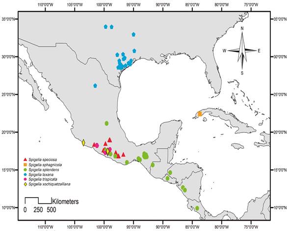
Figure 19: Distribution map of Spigelia speciosa Kunth, Spigelia sphagnicola C. Wright, Spigelia splendens Hort. Wendl. ex Hook., Spigelia texana (Torr. & A. Gray) A. DC., Spigelia trispicata H. Hurley ex K. Gould, and Spigelia xochiquetzalliana S. Islas, Lozada-Pérez & L.O. Alvarado.
Conservation status: Least Concern (LC). This species is found in various states of Mexico. Together the populations reach an EOO: 68,344.20 km2 and AOO: 30,000.00 km2. It is one of the most collected species of the genus, due to its striking red flowers with large green lobes, so there is a lot of information about the populations and their abundance. They have also been collected in different locations in recent years.
Taxonomic remarks: this species is similar to S. chiapensis by the flower shape and color, but S. speciosa is easily differentiated by its absent peduncles (vs. 2-2.5 cm), longer sepals (vs. shorter sepals), lobes of the corolla incurvate (vs. lobes of the corolla straight), and green corolla lobes (vs. yellow). Likewise, S. chiapensis is mainly distributed in grasslands and areas with greater exposure to light (Gould, 1997), while S. speciosa is preferably found in coniferous and mountain mesophilic forest. It also shares similarities with S. marilandica, but its distribution and floral characters (see taxonomic remarks of the species) allow to easily differentiate them.
Specimens examined: MEXICO. Guerrero, municipality Atoyac de Álvarez, Asoladero, km 191 Atoyac - Xochilapa, 29.VI.1982, Lab. de Biogeografía 144 (FCME). Municipality Chilpancingo de los Bravo, cerro Alquitrán (cima), 9.VI.1968, H. Kruse 1807 (MEXU); Valle La Iglesia, Alquitrán, 2.VI.1968, H. Kruse s.n. (MEXU); Barranca de la Perra, 13.II.1994, A. Méndez 426 (FCME); Ixtamalco, 18 km al W de Chilpancingo en el camino a Olmitemi, 6.VI.1985, W. Thomas 3709 (FCME, TEX). Municipality General Heliodoro Castillo, 2 km al Sw del crucero Filo de Caballo - Cruz de Ocote-Chichihualco, 20.VII.1990, L. Hernández 2460 (MEXU, QMEX, TEX); Verde Rico, 5.7 km al N camino a La Ciénega, 12.VI.1999, R. Cruz-Durán 3892 (FCME, MEXU); Tlacotepec, 21.2 km al SE, hacia el Jilguero, 15.VI.1999, R. Cruz-Durán 4045 (FCME, HUMO, MEXU). Municipality Leonardo Bravo, Tres Caminos, 4 km al SO, 27.VI.1997, R. Cruz-Durán 1145 (FCME, MEXU); aprox. 1 km adelante de la desviación a Chichihualco, rumbo a puerto del Gallo, 21.VI.1999, R. M. Fonseca 2743 (FCME); Filo de Caballo, 3 km al SO, 9.VII.1998, B. González 1840 (FCME); camino Carrizal de Bravo a Filo de Caballos, al W de Chilpancingo, 2.VII.2008, L. M. González 5059 (IBUG); 6 km de Filo de Caballos, en el camino a Cruz de Ocote, 1.2 km al W del Cerro Cacho de Oro, 23.VII.1991, A. Mayfield 991 (MEXU, TEX). Municipality Coahuayutla, Cundan - Filo Mayor, 29.VI.1937, H. Kruse 10371 (TEX). Municipality Quechultenango, 2 km antes del poblado de Astatepec, dirección Quechultenango - Astatepec, 18.VII.1983, G. Zamudio 599 (ENCB, FCME, IEB, MEXU). Municipality Taxco de Alarcón, 3 km al E de Ixcateapan, 27.VII.1986, S. Valencia 55 (ENCB, FCME). Municipality Tixtla de Guerrero, La Estacada, 20.VI.2007, A. Hernández 335 (FCME); loc. cit., 27.IV.1997, M. Candela 99 (FCME). Morelos, municipality Tepoztlán, Orilla de tren (camino de terracería) rumbo a San Juan Tlacotenco, 25.VI.1994, R. Cerros-Tlatilpa 301 (IEB, UAMIZ); Sierra de Chalchi, 1.VI.1945, F. Miranda 3532 (MEXU). Municipality Tlayacapan, 4 km al SW de San José de los Laureles, rumbo al Cerro de las Mariposas, 3.VI.1991, R. Cerros-Tlatilpa 203 (UAMIZ); loc. cit., R. Hernández-Cárdenas 447 (HUMO, UAMIZ); Barranca Tepecapa, 17.VII.2010, R. Hernández 447 (IEB). Oaxaca, municipality Oaxaca de Juárez, Sierra de San Felipe, 24.V.1994, C. G. Pringle 4652 (MEXU). Municipality San Miguel del Puerto, Panteón, 16.V.2000, F. López 161 (MEXU). Municipality Santiago Juxtlahuaca, 17 mi al S de Juxtlahuaca en el camino de Huajuapan (en la autopista 190), 2 mi al W de la intersección con la autopista 125 de Putla a Tlaxico, 17.V.1995, K. Gould 136 (MEXU, TEX); 10 km al S de Copala, carr. San Agustín Atenango - Putla, 19.VI.1982, R. Torres 590 (MEXU). Municipality Santiago Yosondúa, a la orilla del río la Esmeralda, 50 m abajo del mirador, 6.VIII.2012, A. García-Mendoza 9878 (MEXU); Paraje Yucuyá, Cabecera de Cañada, 8.VIII.2012, A. García-Mendoza 9990 (MEXU).
Spigelia sphagnicola C. Wright, Fl. Cub. (Sauvalle) 116. 1869.
TYPE: CUBA. En lagunitas de la Vuelta Abajo, ca. de Pinar del Río, s.d., C. Wright 2701 (holotype: MO-2049493!).
Herbs not branched, stem quadrangular, glabrous, without lignification; leaves opposite below the inflorescence, sessile, lamina lanceolate, membranaceous, 0.5-1.5 cm long; stipules present, deltate; inflorescence terminal, monochasium cyme, 1-3 flowers, sessile (Fig. 20A); sepals green with purple apex, lanceolate; corolla hypocrateriform, 1.2-2.5 cm long, tube white, lobes purple, lobes ovate; stamens inserted at the middle part of the corolla tube, included, filaments present; pollen not seen; stigma capitate; capsule glabrous, 2.73 mm diameter, metastyle present, smaller than the capsule, carpoatlas rhomboid (Fig. 20B), transversal ridge absent; seeds not seen.

Figure 20: Morphological characters. Spigelia sphagnicola C. Wright: A. inflroescence; B. carpoatlas. Spigelia splendens Hort. Wendl. ex Hook.: C. inflorescence (Naturalista, 2017); D. carpoatlas; E. seed. Spigelia texana (Torr. & A. Gray) A. DC.: F. inflorescence (Naturalista, 2020f); G. carpoatlas; H. seed. Photographic credits: A), B), D), E), G), H) S. Islas; C) B. Jiménez (https://www.naturalista.mx/observations/6718551 CC BY-NC); F) A. Newman (https://www.naturalista.mx/observations/44368223 CC BY-NC).
Distribution and habitat: endemic species of Cuba (Province Pinar del Río) (Fig. 19). It inhabits humid savannah with white sands (Fernández-Casas, 1998), and is recorded at 50 m elevation.
Conservation status: Critically Endangered (CR). This species is known only from a few specimens collected in Cuba. There are no collection records in the last 20 years, so the populations may be reduced. However, current populations need to be assessed to obtain a better idea of their abundance and environmental conditions.
Taxonomic remarks: Spigelia sphagnicola is one of the species endemic to Cuba such as S. ambigua. It can be distinguished from the latter by the monochasium inflorescence (vs. scorpioid inflorescences), the sepals with purple apex (vs. completely green sepals), as well as for being smaller herbs with lanceolate, almost linear leaves (vs. taller herbs with ovate leaves).
Specimens examined: CUBA. Province Pinar del Río, municipality Pinar del Río, Pinar del Rio City, at a small laguna, 31.X.1943, E. L. Ekman 17871 (TEX).
Spigelia splendens Hort. Wendl. ex Hook., Bot. Mag. 87, t. 5268. 1861.
TYPE: GUATEMALA. Cultivated, 1841, E. Friedrichstahl s.n. (holotype: K-573396!).
≡ Spigelia platyphyllaProgel, Fl. Bras. (Martius) 6(1): 256. 1868.
Herbs not branched, stem cylindrical, pubescent, without lignification; leaves pseudowhorled below the inflorescence, sessile, lamina ovate, membranaceous, 7-16 cm long; stipules present, deltate; inflorescence terminal, scorpioid cyme, 10-20 flowers, sessile (Fig. 20C); sepals green, linear; corolla tubular, 3-4 cm long, tube and lobes red, lobes deltate; stamens inserted above the middle part of the corolla tube, included, filaments present; pollen in monads, suboblate, with medium polar area, 3 simple apertures, without margo on the colpi; stigma terete, style pubescent; capsule glabrous, 5.4-5.7 mm diameter, metastyle present, smaller than the capsule, carpoatlas elliptic (Fig. 20D), transversal ridge absent; seeds rhombic, testa reticulate (Fig. 20E).
Distribution and hábitat: distributed in Mexico (Chiapas, Guerrero, Oaxaca, and Querétaro), Guatemala (Huehuetenango), Honduras, El Salvador, Costa Rica (San José), and Nicaragua (Fernández-Casas and Huft, 2009; Fig. 19). It inhabits coniferous and Quercus forests, tropical deciduous, sub-deciduous and humid forests; is found from 500 to 2000 m elevation.
Conservation status: Least Concern (LC). Spigelia splendens is widely distributed in Mexico and Central America. It has an EOO of 402,223.08 km2 and an AOO of 35,000.00 km2, and has recently been collected from different populations in various locations. Likewise, it is registered within national parks, so the populations are not considered under any category of threat.
Taxonomic remarks: Spigelia splendens is vegetatively similar to S. mexicana, due to the presence of pseudowhorled leaves below the inflorescence, as well as the shape of the corollas. Despite the morphological similarities, S. splendens can be distinguished by its sessile leaves (vs. petiolate leaves), axillary inflorescences with fewer flowers (vs. always terminal inflorescences, with a greater number of flowers).
Specimens examined: COSTA RICA. Province San José, district Escazú, Cerros de Escazú, Escazú a Alto Raicero por Carrizal, 26.IX.1993, B. Hammen 19034 (TEX). GUATEMALA. Department Huehuetenango, municipality Jacaltenango, Huehuetenango, Sajbaná, 27.VII.2006, M. Veliz 17064 (TEX). MEXICO. Chiapas, municipality Bochil, carr. Escopetazo - Pichucalco, 500 m al oriente desvío Lagunitas, 16.V.1995, H. Mejía 331 (CICY). Municipality Chiapa de Corzo, Sumidero, hacia mirador Las Chiapas, 4.VI.1953, F. Miranda 7807 (MEXU); Sumidero, hacia mirador Las Chiapas, 1.VI.1953, L. Paray 6453 (MEXU); km 19 de la carretera al mirador Cañón del Sumidero, 4.VIII.1988, R. Ramírez 234 (MEXU, UAMIZ); 17 km al NE de Tuxtla Gutiérrez, Cañón del Sumidero, 1.X.1984, R. Torres 6388 (MEXU). Municipality Coapilla, proximidad de Coapilla, a los lados del camino, 12.VI.2002, E. Palacios 2795 (MEXU). Municipality Ixtapa, Zinacantan, paraje de Muctajoc por la autopista Mex. 190, 14.VI.1972, D. E. Breedlove 25544 (ENCB). Municipality Jiquipilas, Ejido Tiltepec, 6.VI.2002, C. Chavarría 275 (MEXU). Municipality San Fernando, Predio del Rosario, 21.VI.1951, F. Miranda 7218 (MEXU). Municipality Tuxtla Gutiérrez, 15 km al N de Tuxtla Gutiérrez por el camino al Sumidero, 2.VII.1965, D. E. Breedlove 10643 (ENCB, TEX); mirador La Coyota, Parque Nacional Cañón del Sumidero, 29.VI.2007, J. A. Espinosa 107 (MEXU); km 21 de la carretera Tuxtla Gutiérrez - Cañón del Sumidero, mirador Tepehuaje, 5.VI.1995, J. L. Panero 5758 (IEB, MEXU, TEX); 17 km al NE de Tuxtla Gutiérrez, cañón del Sumidero, 1.X.1984, R. Torres 6388 (IEB). Guerrero, municipality Acatepec, Cerro de Mexcaltepec, 13.VI.2016, A. Hernández 2462 (FCME). Municipality Chilpancingo de los Bravo, 14-14.5 mi al W de Chilpancingo, 28.VII.1968, W. R. Anderson 4948 (ENCB). Municipality Galeana, Sierrita, 28.VI.1939, G. B. Hinton 14361 (US). Oaxaca, municipality San Miguel del Puerto, Rancho San Agustín, 500 m al SW, 30.V.2001, A. Saynes 2161 (SERO, TEX). Municipality San Pedro Tapanatepec, Santa Isabel, al NO de Rizo de Oro, por el camino a La Orquídea y Rodolfo Figueroa, cerca del límite de los estados, 23.V.1985, S. Maya 1670 (OAX, TEX). Querétaro, municipality Pinal de Amoles, Chuvejé, 4.VIII.1998, B. Córdova 661 (IEB, QMEX).
Spigelia texana (Torr. & A. Gray) A. DC., Prodr. 9: 5. 1845.
TYPE: UNITED STATES OF AMERICA. Texas, s.l., V.1836. T. Drummond 321 (holotype: NY-00180344!, isotypes: G00368335!, GH-00061252!).
≡ Coelostylis texana Torr. & A. Gray., Fl. N. Amer. 2(1): 44. 1841.
Herbs not branched, steam quadrangular, pubescent, without lignification; leaves pseudowhorled below the inflorescence, petiolate, lamina ovate-lanceolate, membranaceous, 3-5.5 cm long; stipules present, deltate; inflorescence axillary, monochasium cyme, 1-2 flowers, pedicellate (Fig. 20F); sepals green, linear; corolla infundibuliform, 0.7-1.5 cm long, tube white, lobes white with purple lines, lobes lanceolate; stamens inserted at the middle part of the corolla tube, included, filaments present; pollen in monads, spheroidal, with large polar area, 3 simple apertures, without margo on the colpi; stigma capitate, style pubescent; capsule glabrous, 4.5-6 mm diameter, metastyle present, smaller than the capsule, carpoatlas elliptic (Fig. 20G), transversal ridge absent; seeds elliptic, testa foveolate (Fig. 20H).
Distribution and habitat: species distributed in the United States of America (Colorado and Texas) and Mexico (Coahuila) (Fig. 19). It inhabits tropical deciduous forest, and is found between 1100 and 1600 m elevation.
Conservation status: Least Concern (LC). This species is widely distributed in the United States of America and with some populations in northern Mexico (EOO: 337,792.05 km2, AOO: 47,500.00 km2). Likewise, there have been collections in several locations in recent years, so it is not considered under threat.
Taxonomic remarks: this species is similar to S. hedyotidea, and together with it, the only Spigelia species that are distributed in the northern part of Mexico and in the southeastern United States of America. Both species differ in characters such as the pubescence of the leaves, phyllotaxy below the inflorescence and size of the flowers, characters that allow them to be clearly separated.
Specimens examined: MEXICO. Coahuila, municipality Ramos Arizpe, Cañada el Diente, Sierra de la Pila, J. A. Villarreal 4705 (MEXU). UNITED STATES OF AMERICA. Colorado, county Colorado, along Harvey Creek ca. 07 air miles SSW of its mouth at Colorado River, 18.VI.2013, W. R. Carr 33254 (TEX). Texas, county Austin, cultivated in U.T. Austin Greenhouses, 1.VII.1997, K. Gould 156 (TEX). County Brazoria, San Bernard, 28.VI.1923, B. C. Tharp 2805 (TEX); Lake Jackson, woods along Oyster Creek, 2.V.1953, E. P. Killip 43289 (TEX); Brazoria, 2.IV.1995, K. Gould 135 (TEX); Bottomland hardwood forest surrounding cabin of Dr. Larry Gilbert; south west of town of West Columbia, hwy. 35E to 11459 N, right on CR 791 at "canoe rental" sign, 9.X.1993, K. Gould 62 (TEX), 66 (TEX); Boy Scout Camp on CR 363, ca. 4 mi N of hwy. 35 off rd. 459, 9.X.1993, K. Gould 63 (TEX), 64 (TEX); woods along Cedar Lake Creek, San Bernard NWR, 8.V.1970, R. J. Fleetwood 9753 (TEX); Crowell Ranch, woods, 31.V.1970, R. J. Fleetwood 9798 (TEX); Dance Bayou Unit, San Bernard NWR, along NW-SE road that bisects tract near its center, ca. 0.1-0.2 mi SE of pipeline, ca. 3.2 airmiles NW to NNW of Jct. St. Rt. 35 and FM 534 in Old Ocean Ashwood Quadrangle, 27.V.1999, W. R. Carr 18269 (TEX); Big Pond Unit, San Bernard NWR, ca. 0.9 air miles SW of jct. FM 1301 and FM 524, Danciger Quadrangle, 7.VI.1999, W. R. Carr 18297 (TEX); ca. 1.4 air miles SW of jct. St. Rt. 35 and road to Nash Prairie near East Columbia, 27.IV.2009, W. R. Carr 27739 (TEX). County De Witt, Route #87, 7 miles southeast of Cuero, 6.VII.1957, D. S. Correll 17503 (TEX); cultivated in U.T. Austin Greenhouses, 1.VII.1997, K. Gould 154 (TEX); Western De Witt County, M. Riedel s.n. (TEX). County Gonzales, Palmetto State Park, 11.V.1951, B. C. Tharp 51-555 (TEX); loc. cit., 11.V.1985, D. Lynch 7555 (TEX); 5.9 mi SSE on hwy. 183 from the intersection with hwy. 90A in Gonzales to Chicken ranch, the 2 airmiles E to Guadalupe River, 28.IV.1991, S. Ginzbarg 933 (TEX); ca. 4 mi ESE on US 90 from intersection with RR 532 in Gonzales, then ca. 4 mi SE on Gravel rd. to Kokernot Ranch on Peach Cr., 12.V.1991, S. Ginzbarg 941 (TEX); Iowa Park, s.d., E. Hall 288 (US). County Jackson, along NW bank of East Carancahua Creek, ca. 2.2-2.4 air miles S of jct. St. Rt. 616 and Co. Rd. 449 at Francitas, Francitas Quadrangle, 4.V.2012, W. R. Carr 30588 (TEX). County Lee, N side of Middle Yegua Creek, along improved park road 0.8 road miles SE of its jct. With Co. rd. 430, which is 2.3 road miles E of Co. rd. 430's jct. St. Rt. 141, SE of New Dime Bov, ca. 2.3 air miles N to NNE of jct. St Rt. 141 and F.M. 1697, Lake Somerville Wildlife Managment Area, Dime Box Quadrangle, 19.XI.1995, W. R. Carr 15080 (TEX). County Refugio, Guadalupe R, bottom, 29.V.1932, W. R. Carr 22383 (TEX). County Uvalde, about 5 miles down contry road 418 on bank of stream off the left side of the road, 21.IV.1992, J. Gregory 121 (TEX). County Victoria, Guadalupe R. bottom, 29.V.1932, B. C. Tharp s.n. (TEX); S side of Linn Bayou just upstream from its confluence with Guadalupe River, 50-1000 ft. W of RR trestle, 5.0-5.3 air miles NE of RR crossing of FM 445 at McFaddin, McFaddin Ranch, Bloomington SW Quadrangle, 22.X.2003, W. R. Carr 22559 (TEX); loc. cit., 31.III.2004, W. R. Carr 22930 (TEX). County Waller, Stephen F. Austin State Park, near Sealy, 25.V.1957, D. S. Correll 164 (TEX).
Spigelia trispicata H. Hurley ex K.Gould, Brittonia 51(4): 412. 1999.
TYPE: MEXICO. Guerrero, distrito Mina, Aguazarca-Filo de Caballos, 07.V.1937, G. B. Hinton 10381 (holotype: TEX-256907!, isotypes: G-368331!, NY-102692!, US-00588944!).
Herbs not branched, stem cylindrical, pubescent, without lignification; leaves opposite below the inflorescence, sessile, lamina elliptic-ovate, membranaceous, 1.2-5.3 cm long; stipules present, linear; inflorescence terminal, scorpioid cyme, 3-10 flowers, pedicellate (Fig. 2A1); sepals green, linear; corolla tubular, 3.5-4.5 cm long, tube and lobes red, lobes triangular; stamens inserted above the middle part of the corolla tube, exserted, filaments present; pollen in monads, oblate-spheroidal, with large polar area, 3 simple apertures, without margo on the colpi; stigma capitate, style pubescent; capsule pubescent, 2.5 mm diameter, metastyle present, longer than the capsule; seeds ovoid, testa not seen (Fig. 21B).

Figure 21: Morphological characters. Spigelia trispicata H. Hurley ex K. Gould: A. flower; B. seed. Spigelia xochiquetzalliana S. Islas, Lozada-Pérez & L.O. Alvarado: C. flower (Naturalista, 2019c). Photographic credits: A) B) S. Islas; C) E. Salmerón (https://www.naturalista.mx/observations/32906021 © Reproducida con autorización del autor).
Distribution and habitat: endemic to Mexico (Guerrero) and growing in coniferous and Quercus forests (Fig. 19). It is recorded between 900 and 1800 m elevation.
Conservation status: Near Threatened (NT). This species has been recorded in four populations in the state of Guerrero in Mexico (EOO: 9587.72 km2, AOO: 2353.74 km2). The known populations are recorded in very close localities, and it has not been collected since more than 15 years. Therefore, it is suggested to evaluate the status of the populations at present.
Taxonomic remarks: this species is similar to S. chiapensis; both are small plants with ovate to elliptic leaves, tubular flowers, long corolla lobes and stamens inserted at the apex of the corolla tube. They can be distinguished by the short-pedunculate inflorescences, flowers 40-50 mm long (vs. 60-80 mm) and red corollas with white lobes internally (vs. red corollas with yellow lobes externally).
Specimens examined: MEXICO. Guerrero, municipality Ajuchitlán del Progreso, Chilacayote - Carrizal, 2.VII.1939, G. B. Hinton 14380 (ENCB, TEX). Municipality Gral. Heliodoro Castillo, Mesa Queisle, 11.VII.1937, G. B. Hinton 10453 (TEX); Aguazarca, 6.V.1937, G. B. Hinton 10487 (US). Municipality Zirándaro, 5 km al SE de Guayameo, 14.VII.1982, J. Calónico 4138 (MEXU), 4156 (ENCB, MEXU); Los Parajes, 2.73 km al SO, 22.VII.1999, J. Calónico 15193 (FCME): loc. cit., 23.VII.1999, J. Calónico 15324 (FCME).
Spigelia xochiquetzalliana S. Islas, Lozada-Pérez & L.O. Alvarado, Phytotaxa 303(2): 119. 2017.
TYPE: MEXICO. Guerrero, municipio Acapulco de Juárez, Cerro Cebadilla, 3.VIII.2003, L. Lozada et al. 2588 (holotype: FCME-158129!).
Herbs not branched, stem quadrangular, glabrous, without lignification; leaves pseudowhorled below the inflorescence, sessile, lamina elliptic-ovate, membranaceous, 9.7-17.7 cm long; stipules present, deltate; inflorescence terminal, scorpioid cyme, 11-17 flowers, pedicellate (Fig. 21-C); sepals green, lanceolate; corolla infundibuliform, 2-2.5 cm long, tube white, lobes white with purple apex, lobes deltate; stamens inserted above the middle part of the corolla tube, included, filaments present; pollen in monads, oblate-spheroidal, with medium polar area, 3 simple apertures, without margo on the colpi; stigma capitate, style pubescent; capsules not seen; seeds not seen.
Distribution and habitat: endemic species of Mexico (Guerrero and Michoacán) (Fig. 19). It lives in tropical deciduous and sub-deciduous forest, and is recorded between 100 and 1000 m elevation.
Conservation status: Vulnerable (VU). This species has been recorded in three populations in the region of the Pacific Ocean coast in Mexico (EOO: 14,904.86 km2, AOO: 6373.86 km2). However, the known populations are in an area with significant urban growth and there are no data on the abundance of individuals. Recently, Edgar Salmerón Barrera recorded observations of this species on the iNaturalist platform (Naturalista, 2019c; Naturalista, 2020g; Naturalista, 2022) for the state of Guerrero (Naturalista, 2021a). These new zones increase the known distribution of the species and some of them are in areas of difficult access that may help to conserve populations.
Taxonomic remarks: this species is morphologically similar to S. humboldtiana, due to the herbaceous habit, the shape of the leaves and the infundibuliform corolla. Spigelia xochiquetzalliana can be distinguished by the monochasium inflorescences (vs. branched inflorescences in S. humboldtiana), internally purple corolla lobes (vs. internally white lobes), and potentially protogynous flowers with the style exserted prior to anthesis (vs. not protogynous with the style included, even at anthesis).
Specimens examined: MEXICO. Guerrero, municipality Acapulco de Juárez, Cerro Cebadilla, 3.VIII.2003, L. Lozada 2588 (FCME). Municipality Mochitlán, Mochitlán, 11.IX.2012, M. Venalonzo 13715 (FCME); loc. cit., 15.IX.2012, R. Santos 13686 (FCME). Michoacán, municipality Aquila, 2 km al N del Rancho Barranca del Potrero, 1.IX.1979, B. Guerrero 311 (XAL).
Discussion
The genus Spigelia has a considerable diversity in NA, with about 30% of the species in this region, underestimated in previous works (Gould, 1997; Fernández-Casas and Huft, 2009; Villaseñor, 2016), distributed in tropical and subtropical zones, with an important presence along the coasts, from the United States of America to Panama. The genus inhabits mainly in tropical deciduous and sub-deciduous forests, with a high number of species also present in humid forests, mountain mesophilic forest and coniferous and Quercus forest (Gould, 1997; Fernández-Casas, 1998; Islas-Hernández et al., 2017a).
Of the 29 species distributed in the NA region, 23 of them are found in Mexico, followed by the United States of America and Guatemala with six species each. This diversity corroborates Mexico as the center of diversity in NA for the genus (Gould, 1997; Islas-Hernández et al., 2017a). In addition to this high diversity, about 80% of the species distributed in NA are exclusive to this region, with Mexico, the United States of America and Cuba as the countries with the highest number of endemic species with fourteen, three and two, respectively.
In the NA region, Mesoamerica constitutes one of the regions in which plant diversity is most concentrated, classified as a biodiversity hotspot (Sosa and De-Nova, 2012). Within this region, Mexico stands out as a country of high biological diversity and endemism, which is mainly due to the fact that the country has a complex geological history (Ferrusquía-Villafranca, 1993), which is responsible for an abrupt topography that allows the presence of practically all the major types of vegetation known on the planet (Villaseñor, 2003), a condition that is only shared with India and Peru. In addition to this, Mexico, unlike the rest of the countries in the NA region, presents a combination of boreal and southern elements, as well as a high diversity in arid zones, similar to what occurs in Brazil in the SA region (Rzedowski, 1991).
A high number of endemic species in the region, mainly in Mexico and Cuba, have restricted distributions that have been associated with the numerous biogeographic barriers in both countries (Fernández-Casas, 1998; Gould, 1999; Islas-Hernández et al., 2017a, b; Islas-Hernández and Alvarado-Cárdenas, 2020). Associated with these geographical conditions, several species, mainly endemic and microendemic ones, are known only from the type specimens (e.g., Spigelia ayotzinapensis, S. colimensis, S. dolichostachya, S. elbakyaniae, S. queretarensis, S. sphagnicola), have distributions that are threatened by anthropogenic activities (e.g., Spigelia chiapensis, S. gentianoides, S. guerrerensis, S. mexicana, S. mocinoi, S. trispicata, S. xochiquetzalliana) or have not been collected in about a century. Therefore, the updated knowledge of their morphology and distribution will allow the recognition of taxa, as well as the designation of areas that allow their conservation.
To this end, detailed knowledge of vegetative structures allows the elaboration of keys that facilitate identification before it is necessary to resort to reproductive structures. These characteristics, such as the presence of stipules or the phyllotaxis below the inflorescences, allow, in the absence of flowers, to approach to the identification of the species, which can be subsequently corroborated with the help of the diagnoses. Likewise, it has been observed that carpological characters present an important variation that allows the delimitation of species for their identification, even if the plant no longer has flowers or fruits (Islas-Hernández et al., 2022).
The detailed knowledge of the morphological structures that help to identify the species (e.g., type of style, pollen, carpoatlas or shape of the seeds), can be integrated as morphological markers, which together with the molecular markers will allow in the future to generate combined phylogenetic analyzes (Peterson and Seberg, 1998). In this sense, the use of carpological characters for the separation of groups of species has been studied within the genus (Islas-Hernández et al., 2022), and this information will allow, together with the floral information, the proposal of new sections that have phylogenetic congruence (Gould, 1997) and that are complemented with information derived from the species of the SA region.
This study represents the first taxonomic treatment for the genus Spigelia that includes all the species of the central and northern region of the continent. The information collected in this work, some of it described in detail for the first time (pollen, carpoatlas, seeds), may be useful to be integrated into phylogenetic analysis that help resolve the intrageneric relationships of the group. Likewise, the application of potential distribution modeling tools would allow the localization of areas for future collections, as well as the development of biogeographic analyses to help understand the distribution patterns of Spigelia species across the continent.

