


Services on Demand
Journal
Article
 text in
  English (pdf)
 Article in xml format
 Article references
 Send this article by e-mail
Indicators
-
 Cited by SciELO
 -
 Access statistics
Related links
-
 Similars in
SciELO
Similars in
SciELO
Share

 Permalink
Estudios fronterizos
On-line version ISSN 2395-9134Print version ISSN 0187-6961
Estud. front vol.22 Mexicali 2021 Epub Oct 04, 2021
https://doi.org/10.21670/ref.2107070
Articles
The north door of the “Chilean dream”. Border city, migrant settlement and precariopolis in Arica, Chile

aPontificia Universidad Católica de Chile, Instituto de Geografía, Santiago, Chile, e-mail: rodrigohidalgogeo@gmail.com, cdvc87@gmail.com, mgonzalezro.fe@gmail.com
An analysis of Arica (Chile) is presented as a border city. It aims to describe and analyze the migratory mobility of the city of Arica and the settlements where the migrant population resides, a discussion centered on Latin American bibliography on border cities, mobility, migration and human settlements is proposed, where we resort to the categories of the ghetto and precarious city. Data production techniques were applied combining statistical production from official sources together with observation and documentary analysis. The results show that the migrant population is mainly Peruvian, Bolivian and tends to be in three large areas of the city: north, south and valley of Azapa. It is specifically investigated in the case of Cerro Chuño, which is problematized as a migrant settlement, discussing the expression of ghetto and precarious city.
Keywords: border city; migrations; precariousness; Cerro Chuño
Se presenta un análisis de Arica (Chile) en su condición de ciudad frontera. Con el objetivo de describir y analizar la movilidad migratoria de la ciudad de Arica y los asentamientos donde reside la población migrante, se plantea una discusión centrada en bibliografía latinoamericana sobre ciudades frontera, movilidad, migración y asentamientos humanos, donde se resaltan las categorías de gueto y precariópolis. Se aplicaron técnicas de producción de datos que combinan producción estadística de fuentes oficiales en conjunto con observación y análisis documental. Los resultados muestran que la población migrante es mayoritariamente peruana, boliviana y tiende a localizarse en tres grandes áreas de la ciudad: norte, sur y valle de Azapa. Se indaga específicamente en el caso de Cerro Chuño, el cual es problematizado como asentamiento migrante bajo la discusión de las expresiones de gueto y precariópolis.
Palabras clave: ciudad frontera; migraciones; precariedad; Cerro Chuño
Introduction
In recent decades, Chile has experienced a significant migratory phenomenon. Between 2018 and 2019 alone, the foreign population increased almost 20%, going from 1 250 365 to 1 442 522 (Instituto Nacional de Estadísticas [INE] & Departamento de Extranjería y Migración [DEM], 2020). Consequently, as analyzed in general terms and specifically for the border city of Arica, the Chilean case is characterized by being intense in a short number of years ─the doubling of that population between 2014 and 2019─ according to official figures (INE & DEM, 2020). This phenomenon has an effect on the different socioeconomic, productive, and territorial structures of the country.
This paper focuses on the spatial production where these migrations materialize, especially in the city margins, in places overshadowed by the bonanzas of neoliberal globalization (Sassen, 2016a, 2016b). Therefore, the causes of population mobilities are located between the political sphere of nation-states and the governance of large business corporations, which put a strain on the global and the local (Sassen, 2003). These centralities of power constitute the contemporary geopolitical sphere that provokes expressions of a previously unobserved migration, in contexts that are sometimes apocalyptic, involving climate change and loss of habitat, which can lead to humanitarian crises (Sassen, 2016b).
The urban expressions of these human mobilities often result in the densification or formation of precarious settlements (Canales et al., 2019; Mora, 2009), with the formation of ghettos and confinement spaces for the migrant population. Mobile modes of inhabiting manifest themselves in these spaces, with an often unimagined tendency toward permanence for the people involved.
In this context, the work presented here refers to Arica, a border city in northern Chile with a population of around 221 000 inhabitants. Arica has received a considerable proportion of migrants since the late 2000s. This border condition generates “waiting” spaces for people who, searching for the mythical “Chilean dream”, arrive in the country with the expectation of having a good job and better living conditions. On this journey, the original destination for the migrant population is the capital, Santiago, or other northern cities, with Arica being predominantly a transit city.
In the course of their mobility, many remain in transit and begin to swell the ranks of the precariously employed masses who live in substandard housing or recycle subsidized housing complexes built in the 1990s. The specific case analyzed is the Cerro Chuño housing complex, located at the northern entrance to the city, which serves as a paradigmatic example of the aforementioned process. This paper proposes the concepts of precariopolis (Hidalgo, 2007) and ghetto (Wacquant, 2010) to analyze the materiality of these spaces that are linked to the Chilean reality of the effects of the subsidized housing policy.
Despite its peripheral and frontier location, Arica is an example of the rescaling (Valdebenito & Navarro, 2019) of medium-sized or smaller cities that world urbanization is developing, a product of the reordering of the global political economy. Thus, this paper aims to describe and analyze the migratory mobility of Arica and the settlements where migrants reside to specify how they have produced their inhabited space, based on the categories of precariopolis and ghetto they assume in Arica.
Accordingly, this paper first presents the methodological research proposal to establish the definitions of border cities, settlements, and migrant mobilities. It then addresses the concepts of ghetto and precariopolis associated with urbanization and production of space. Following that, it analyzes the structure and dynamics of migratory mobility in Arica. It concludes with the analysis of the case of Cerro Chuño and the forms of location of this population on the periphery of the city.
Methodology
The methodological design is of a mixed nature. First, quantitative and qualitative techniques are used since the complexity of the problems addressed requires overcoming false dichotomies that structure research methods in the social sciences (Bourdieu et al., 2000). Accordingly, the data production techniques used were descriptive statistics, observation, and documentary analysis (Table 1).
Table 1 Techniques, data, and products
| Data production technique | Procedure | Specificities and use |
|---|---|---|
| 1) Descriptive statistics | 1.1) Univariate statistics | 1.1) Migration flow by year and nationality |
| 1.2) Variable crossing | 1.2) Ratio of the migrant population by city zone (census district) | |
| 1.3) Construction of synthetic indices: overcrowding and housing quality | 1.3) The overcrowding index implies the division of the total number of rooms occupied exclusively for sleeping by the total population of the household. The standard used as a boundary for overcrowding is a maximum of 3.5 persons per room. Anything higher is considered overcrowding. | |
| The housing quality index considers three variables from the Population and Housing Census: the materials used in the roof, walls, and floor of the dwelling, where segmentation is made of households with precarious materials and those without them. Then, the population that does have good materials is divided by the total number of households. Next, a sum of each of these variables is added up and divided by three, which generates an index ranging from 0 to 1, where 0 means greater precariousness and 1 means the absence of precariousness. | ||
| 2) Observation | Definition of observation scenarios according to the division of the city by macro zones (center, north, south, peri-urban). Specification of observation for Cerro Chuño population. | General landscape characterization: housing typology; location of infrastructure, equipment, and services in zonal or neighborhood structures; population dynamics and flows according to access and transit. Application of qualitative content analysis to data produced. |
| 3) Documentary review | Compilation of press sources, documents from non-governmental organizations, government agencies, and audiovisual documents related to the Cerro Chuño population. | General characterization of the Cerro Chuño problem, reviewing press coverage, the voices of the population that generates the historical narrative, and the mechanisms used by non-governmental organizations and the State. |
Source: created by the author
The statistical analysis was based on two sources, the annual registry of the Department of Immigration and Migration and the Population and Housing Census. These helped form a longitudinal overview of the migratory dynamics of Arica, distinguishing nationalities, sex, age, and educational capital. This study added to this list the construction of synthetic indices to investigate spatial differences in migration. Furthermore, it applied an index of household overcrowding and an index of housing quality, both of which made it possible to appreciate the distribution of these variables according to the census division used by the State of Chile and the city of Arica.
This study complemented the statistical evidence with the collection of qualitative data. At this point, field observation of these spaces was key since this technique helps to comprehend the experience of inhabiting the place and the realities of daily life by considering their immanent dynamics (Pellicer et al., 2013). The observation scheme and the insertion strategy were defined based on Guash (1996). Following the first point, indirect observation of the urban space of the city of Arica was carried out. Regarding the second point, Cerro Chuño was accessed with the help of a key informant, an inhabitant of a neighboring town. This enabled the researchers to go relatively unnoticed, which made possible the construction of field notes and photographic images to illustrate the urban deterioration of the neighborhood and typical street scenes, outlining the way of life in it and its relationship with the rest of the city.
Finally, a review of public documentation on the particular conflict of Cerro Chuño took place, including news from the local press (El Morrocotudo and Arica al Día), NGO reports (National Institute of Human Rights), and ministerial agency registries (Ministry of Housing and Urbanism). All these data were subjected to a qualitative content analysis based on categories and codes extracted from the texts reviewed.
Border cities: typologies, settlements, and migrant mobility
Border cities correspond to a category of complex cities, which is expressed in their functionality, form, and socio-productive diversity. Thus, it is understood that border cities are urban areas where the State, as a vector of territorial organization, exacerbates and condenses the political, economic, and social model. Therefore, they are defined by their geographic position, the interactions of the societies living on either side of the border, the flows and halts that produce an urban entity on the borders, and the scale used (Steiman, 2012; Zarate, 2012).
These are usually established as transit cities for migrants, where in many cases, halts are more temporary due to work activities or advantages, or political, economic, or legal limitations that prevent greater dynamization of mobility (Coubès et al., 2020; Alarcón, 2019; Mendoza, 2014).
Research on border cities is recent and corresponds to the field of border studies. These studies focus mainly on analyzing the differences in economic dynamism on either side of national borders concerning the areas of common urbanization that respond to these dynamics (Alegría, 2009; Herzog, 1991).
In some cases, cross-border metropolises arise that share common problems (Herzog, 1991), defying conventional policies of national states. This phenomenon is observable in the border cities of Mexico and the United States, and also between Latin American countries, which face the consequences of the intense mobility generated in these spaces (Sohn, 2014; Steiman, 2012; Brites, 2018).
In South America, one of the derivations of the transboundary metropolis concept is that of twin cities or binational cities (Ehlers et al., 2011). These types of cities make it possible to describe the growth of urban space and the cultural relations between the inhabitants of these places. In addition, from an operational perspective, twin cities allow for the questioning of state policies on the border, the different socio-spatial scales, and the phenomena associated with social interaction and mobility between them (Steiman, 2012).
Studies such as that of Posadas-Encarnación on the Argentina-Paraguay border, and on the triple border of Brazil, Paraguay, and Argentina ─the location of the Itapú hydroelectric power plant─, account for the spatial, social, and environmental effects of the construction of extractivist megaprojects and the intensification of neoliberalism (Brites & Catullo, 2016; Brites, 2018; Souza & Brites, 2017). Some of the relevant aspects for the studies of these spaces are the transport of goods and the mobility of people, as well as the illegal trafficking of products, drug trafficking, human trafficking, migration outside the regulatory framework, and violence (Espín, 2013; Dorfman, 2015; Trejos, 2015; Dammert & Bensús, 2017).
In this context, three points characterize a border area: there is no single urban ecology, cross-border markets are not integrated, and there are profound differences in the planning and management of the cities (Alegría, 2009). For example, Hiernaux (1994) demonstrates that regional border economic development policies, with the installation of maquiladora industries, boosted internal migration from the country to these cities, which is one factor in urban growth.
In this aspect, although there are exchanges between both sides of the border, these are an effect of financial and multinational flows that form “winning” and “losing” spaces, whose effects are observed in different uses and scales. In the residential sector, gated communities on the peripheries of cities represent the contrasts in living conditions generated by the inequality of economic development, which can be observed, for example, on the Mexican border (Méndez et al., 2005; Enríquez, 2007; Peña, 2015).
These changes in habitat and habitation not only take shape in those spaces where middle and upper classes reside ─who are originally from those places or are part of the labor mobility of better socioeconomic standards of the same countries─, but also where national or foreign migrants arrive in precarious settlements, many of them of a transitory nature with a tendency to become permanent (Canales et al., 2019; Mora, 2009). Just as new housing developments are being built, some existing ones are also being densified. In the latter case, a rental market accommodates this demand, reflected in the rental of rooms or beds without provision of services (Fernández Niño et al., 2018; Cordero et al., 2019).
Examples of such places can be found all over the world. In Europe, there is the recent case of Calais in France, near the English Channel, which became a symbol of the precariousness of a settlement formed by the crisis of migrants fleeing the Syrian conflict and the Islamic State, whose destination was the United Kingdom (Sassen, 2016b). In a different context ─but also of a humanitarian crisis─ is the case of the Central American migrant caravans seeking the “American dream”. On their way, they enter places of refuge or precarious settlements on the periphery of Mexican border cities (Canales et al., 2019; Cordero et al., 2019).
Underlying these dynamics is the global phenomenon of mobility, understood not only as the implicit migratory process to cities, but also as the current condition of movements of goods, services, ideas, people, and exchanges on the surface of the earth, which are taking place at a transformative speed not observed before in the evolution of humanity (Salazar, 2019).
Mobility has intensified due to greater economic dynamization within the framework of capitalist globalization to generate spatial transformations (Martínez Pizarro, 2000; Muñoz Jumilla, 2002), which involve anything from daily commutes in large cities to phenomena of interregional scale. These may be caused by commuting to work, study, or tourism, among other aspects (Módenes, 2008; Rodríguez & Espinoza, 2012).
Even migrant mobility of a more precarious nature combines residential spaces with different degrees of transience in areas of the city with a greater level of deterioration. For example, Jiménez (2017) analyzes the structuring of “migrant ghettos” in relatively abandoned neighborhoods in Santiago de Chile. Schiappacasse (2008) also inquiries into the production of socioeconomic residential segregation and migrant confinement. This framework requires a general review of the concept of ghetto. Its relationship with the precariopolis, a concept used to describe the urban areas of marginalization produced by the Chilean subsidized housing policy, can provide tools to think about the formation of spaces such as the city's periphery and, in particular, Cerro Chuño.
The categories of ghetto and precariopolis as a basis for empirical analysis
The concept of ghetto has a long tradition in urban studies and has been applied to various realities of society, from Jewish ghettos in Europe to African-American ghettos in North America (Wacquant, 2013; Sternberg, 2017). With over 500 years of usage, the word is of Italian origin. Etymologically, it refers to a place of metal smelting. The origin would have been in a neighborhood in Venice specialized in that activity. The word expressed separation and enclosure, according to the 1907 etymological dictionary by Pianigiani, an issue that materialized in the confinement of the Hebrew community of Venice in 1516, where Italian and German Jews were excluded in a separate area of the city (Wacquant, 2013).
In an unfinished debate, Wacquant (2001, 2010, 2013) postulates that a ghetto is a socio-spatial apparatus of segmentation and ethno-racial control, an expression of the inequality and fragmentation of the salaried labor force. Thus, the ghetto is an institutional device that uses space to combine two opposed goals: maximizing material benefits extracted from a group considered “contaminated” and minimizing intimate contact with those same members. Therefore, the ghetto implies two faces. On the one hand, it fulfills opposite functions for the fenced-in and unfenced-in groups, which it unites in a relationship of asymmetrical dependence. On the other hand, confinement and enclosure do not imply the absence of internal integration and protection. External isolation intensifies social contact and cultural forms inward (Wacquant, 2010).
For a ghetto to emerge, spatial confinement must be imposed. It must have a distinctive and duplicated set of institutions that allow the enclosed group to reproduce itself within the perimeter. Thus, a ghetto is a machine for the production of tainted identities. However, stigma production can also increase the collective pride of those symbolically damaged (Wacquant, 2010).
The ghetto in Latin America is associated with the urban living conditions of the working classes. There is a tendency to exemplify the ghetto with the marginality and housing isolation that these groups of people resist (Sabatini & Brain, 2008; Delfino, 2012). Studies tend to emphasize the quantitative indicators representing them in terms of income and education (Moreno-Izquierdo & Lucero, 2010) and their preponderant demographic characteristics (Saraví, 2020). Therefore, what remains is to delve deeper into the production of space and the morphology that, in socio-spatial terms, the ghetto creates in cities. As Carlos (2007) points out, the urban ghetto is the effect of the relationship between social morphology and spatial hierarchy, which segregates groups in the urban fabric where forms of the appropriation, use, constitution of identity are produced.
From the above, this study understands that the category of the ghetto is a space in the city inhabited by a population with common characteristics where, beyond their multiethnic origins, there is a similar origin in their survival strategies and ways of life. At the same time, this is a space of confinement, which begins by being assumed as transitory but can become fixed and permanent.
An essentially precarious habitat characterizes these places. In Chile, the concept of the precariopolis has made it possible to think about the production of these spaces. Understood as complementary to the ghetto, it is a descriptive and analytical meaning of urban forms produced by marginality and precarious subjects living with social stigmas in neoliberal contexts.
The precariopolis is originally associated with housing complexes built by the State on the periphery of cities. It grants access to urban services (sanitation, electricity, and roads) but denies access to the well-equipped city. Thus, it is urbanization without a city that generates and houses precarious lives, marked by the absence of human security values beyond the residents' economic and consumption capacity (Hidalgo, 2007, 2018).
Access to housing for informal immigrants is trapped between the speculation of those who manage rental or buying and selling markets and the immediate need for survival associated with the condition of poverty, which excludes them from the normal process of access to services. Thus, the concept of precariopolis within a border city needs to be broadened to describe the migrant condition relative to the inhabited space and the deployment of strategies and practices to locate and access housing beyond the formality of the mechanism.
This condition of precariousness places the person in an asymmetrical relationship defined by constant insecurity. The constant uncertainty and sense of danger is a contingent rule, not an exception. Thus, the ground is paved for governments to reproduce securitarian policies of population control. For Lorey (2016), precariousness cannot cross a certain threshold; otherwise, it would provoke the possibility of insurgency. This is where the State interposes itself, precisely to govern at that threshold.
This form of precariousness is linked to people's life trajectories left behind and subsumed in the forms of capitalist production. They relate to the planetary insecurity posited by Sassen (2016b), which identifies human beings exposed to inequality, to their condition of passengers in transit and constant recyclers of their living conditions, without ever being recognized by the prevailing system of social production (Butler, 2006).
Arica, a border city: recent flows of migration dynamics
The city of Arica occupies a peripheral position in the Chilean context. It is the capital of the region of Arica and Parinacota, in the extreme north of the country, a political-administrative unit recently created in 2008 (González & Ovando, 2010). The city represents 97.8% of the region’s total population, serves as a border city, and is located 56 km from the city of Tacna, Peru. The closest Chilean city is Iquique, located approximately 300 km to the south. However, Arica is located in a central position in the South American continent. It is the northern gateway to the country, where the reception of the migrant population throughout its history has been constant.
Arica is located in an essentially dynamic territory where the presence of the Aymara ethnic group ─to name only one of the most important─ is decisive due to its traditional mobility across the different ecological levels, between the highlands and the coast (Díaz & Tapia, 2013; González, 2019). In the modern context, the city of Arica was originally founded under the Peruvian state. However, it was transferred to Chilean rule in 1883 as a result of the War of the Pacific between both countries, as well as Bolivia. This background is not a mere detail because today, in geopolitical terms, the region where Arica is located is a porous border area, which is reflected in its migration flows and the centrality the city assumes due to its status as a port (Dilla, 2005; González, 2015, 2019).
From the mid-twentieth century to the present, the main migratory dynamics have been associated with the productive phases that the city experienced. The regional policy of those years, related to a process of “inward” growth, favored creating a free zone linked to the port and the promotion of industrialization (Pizarro & Ríos, 2005; González & Ovando, 2019). For the same reason, the city was attractive for migrants from other regions of the national territory. In that period, professionals and technicians in state positions, workers in educational and hospital services, and families let go from the saltpeter mines. Among others, they arrived to settle in a city that was transforming the urban space from its traditional form. In parallel, the migratory dynamics are characterized by indigenous populations, mainly of Aymara ethnic origin, coming from the highlands and regional valleys, such as Putre, Caquena, Codpa, Ticnamar, Azapa, and Vitor, among others (Meza, 2019; Ovando & González, 2019).
Since the 1980s, Aymara migration has produced a “depopulation” of the rural sectors of the region, as the younger generations left their homes of origin motivated by a city that offered them the possibility of modern development (Chipana, 1986). One of the anthropologists who studied these peoples identified in this process the concrete possibility of the extinction of the social reproduction of this culture, which was defined as a “holocaust of progress” (Van Kessel, 2003).
Contemporary interpretations indicate that a circular movement characterizes the current type of migration rather than a process of depopulation and displacement of origin-destination. This circular movement is essentially a phenomenon of the flow between cities, valleys, and highlands, which transcends state borders because many of these communities have kinship ties with families living in Bolivia (Meza, 2019).
Linked to the border with Peru, travel to and from Tacna is a daily occurrence. The inhabitants of Arica travel to Tacna for tourism, food, clothing, and health services. For the population of Arica, Tacna offers lower health care costs than Chile. Likewise, for the population of Tacna, Arica offers tourism and leisure services such as the beach and specialized consumer markets. Travel between Arica and Tacna is done by bus, collective cabs, or train, with the latter recently having been renovated for tourist use. This is what some authors define as cross-border mobility in a circulatory territory (Tapia et al., 2017; Guizardi & Valdebenito, 2016; Valdebenito, 2017; Podestá, 2011).
In this context, the figures of the National Customs Service report an intense situation of mobility. Thus, for example, the Chacalluta pass border crossing, located 12 km from the city of Arica, represents more than a third of the national total of private vehicle and passenger traffic both entering and leaving the country, which reached six million by 2016 (Tapia et al., 2017).
Accordingly, the interdependent dynamics with Tacna can define the city of Arica as a cross-border metropolis (Herzog, 1991). However, this does not configure a common urban area since there is still a wide separation in the desert space that occupies the border area of both countries. Similarly, understanding it as a twin city (in this case with Tacna) means that they have a similarity and interaction beyond the border (Brites, 2018), an issue that, for now, is undecided.
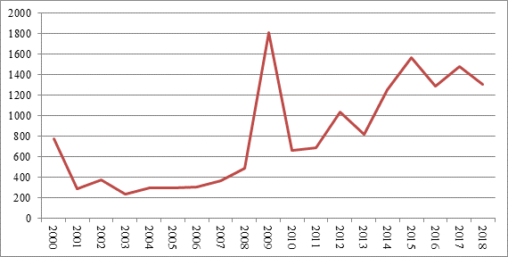
Source: created by the author based on the Department of Immigration and Migration (Departamento de Extranjería y Migración, 2019).
Figure 1 Definitive residence permits granted by the Department of Immigration and Migration, region of Arica and Parinacota
Given these high levels of flow, the number of foreign migrants may seem small. However, their presence has doubled in the last decade, even if only the official records of the Department of Immigration and Migration of the Ministry of the Interior and Public Security are taken into account (Figure 1). These figures could be even greater if “undocumented” migration is also considered. According to Pérez et al. (2015), in the region of Arica and Parinacota ─only between 2011 and 2013─ about 5 000 sanctions were issued for exercising labor functions without a visa. This gives a minimal picture of migratory mobility.
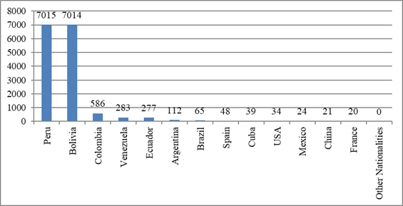
Source: created by the author based on the Department of Immigration and Migration (Departamento de Extranjería y Migración, 2019).
Figure 2 Entry into the country according to nationality in the region of Arica and Parinacota
The results of analyzing entry into the country according to the nationality of origin indicate that of nearly 16 000 definitive residences granted between 2000 and 2018, Peru and Bolivia account for approximately 90%. Colombia (3.74%), Venezuela (1.8%), and Ecuador (1.7%) follow with figures that do not exceed 4% (Figure 2), numbers that only confirm the role of the migrant neighborhood that this border city provides. Other characteristics of the migrant population can be observed through the analysis of the 2017 census. It illustrates that the migrant population is predominantly female, that the majority of heads of household (women or men) have up to 12 years of schooling (72%), 18% have technical professional training, and almost 10% have more than 16 years of schooling, i.e., university education. However, beyond these general data, it is important to investigate the distribution of this population within Arica, relating its presence to the general housing characteristics in certain areas of the city.
The migrant population in the precariopolis of Arica
The migrant population tends to be located in three large areas of the city of Arica, the north, the south, and the Azapa valley. As presented in Figure 3, the Azapa Valley holds practically one-third of this population. The rest of the population is distributed unevenly throughout the census units of the territory of Arica, although the districts of Pedro Blanquier, Chinchorro, Cancha Rayada, Fuerte Ciudadela, Chaca, and Molinos stand out.
Table 2 Gender and population by district. Overcrowding and housing quality index.
| Census district | Men | Women | Total | Total district population | % Migrant population | Overcrowding of the migrant population | Total population overcrowding | Housing quality index |
|---|---|---|---|---|---|---|---|---|
| Puerto | 229 | 218 | 447 | 2 546 | 17.56 | 1.57 | 3.64 | 0.93 |
| Regimiento | 206 | 256 | 462 | 4 454 | 10.37 | 2.87 | 3.36 | 0.96 |
| Chinchorro | 606 | 735 | 1 341 | 20 728 | 6.47 | 4.89 | 3.16 | 0.98 |
| San José | 233 | 333 | 566 | 11 932 | 4.74 | 5.63 | 3.75 | 0.92 |
| Población Chile | 249 | 382 | 631 | 8 237 | 7.66 | 3.22 | 4.06 | 0.89 |
| Azapa | 3 086 | 3058 | 6 144 | 21 601 | 28.44 | 0.91 | 3.87 | 0.74 |
| José Manuel Balmaceda | 261 | 374 | 635 | 11 000 | 5.77 | 4.43 | 3.91 | 0.93 |
| Carlos Dittborn | 276 | 487 | 763 | 9 907 | 7.70 | 3.53 | 3.68 | 0.93 |
| Parque Lauca | 137 | 158 | 295 | 4 216 | 7.00 | 3.83 | 3.73 | 0.89 |
| José Miguel Carrera | 128 | 168 | 296 | 5 218 | 5.67 | 4.68 | 3.76 | 0.91 |
| Condell | 133 | 197 | 330 | 5 506 | 5.99 | 4.74 | 3.52 | 0.95 |
| Fuerte Ciudadela | 550 | 897 | 1 447 | 36 633 | 3.95 | 6.78 | 3.73 | 0.95 |
| Chaca | 83 | 96 | 179 | 338 | 52.96 | 0.56 | 3.35 | 0.47 |
| El Morro | 173 | 233 | 406 | 3 028 | 13.41 | 2.05 | 3.64 | 0.91 |
| Chacalluta | 336 | 297 | 633 | 2 966 | 21.34 | 1.42 | 3.30 | 0.76 |
| Molinos | 85 | 71 | 156 | 478 | 32.64 | 1.09 | 2.81 | 0.69 |
| Pedro Blanquier | 707 | 904 | 1 611 | 31 324 | 5.14 | 5.24 | 3.71 | 0.95 |
| Cancha Rayada | 499 | 742 | 1 241 | 27 530 | 4.51 | 5.81 | 3.82 | 0.95 |
| Las Torres | 349 | 491 | 840 | 11 775 | 7.13 | 3.74 | 3.75 | 0.92 |
| Rezagados | 472 | 251 | 723 | 1 947 | 37.13 | 0.19 | 14.32 | 0.87 |
| Total | 8 798 | 10 348 | 19 146 | 221 364 | 8.65 | 3.12 | 4.14 | 0.92 |
Source: created by the author based on the Population and Housing Census (INE, 2017)
On the one hand, it is striking that the location of these population clusters in the Azapa district corresponds to one of the peri-urban areas of the city in the San José river valley. However, on the other hand, this peripheral area of the city is a center of agricultural activity and has seen its housing stock grow in recent years, especially concerning a change of residence of the upper classes, who come to live in gated condominiums or plots of land.
However, at the same time, agricultural production has continued in this sector, especially the cultivation of olive trees and other fruit trees, which have traditionally employed people from Peru and Bolivia. That population provides domestic service and care for older adults in the rest of the city (Leiva et al., 2017; Stefoni, 2009; Tapia, 2015).
The districts of Chaca and Molinos have a markedly rural character. It is striking that migrants play a decisive role in their demographic structure. Although the number of inhabitants is small, they make up half or a third of the population, respectively. The population in these areas ─and Azapa─ live in more precarious housing, with problems in the roofs, floors, or walls. However, districts such as Pedro Blanquier, Cancha Rayada, or Fuerte Ciudadela do not suffer from overcrowding (Table 2; Figure 3).
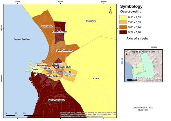
Source: created by the author using Arc Gis 10.1 based on the Population and Housing Index (INE, 2017)
Figure 3 Overcrowding in Arica
These last three districts (Cancha Rayada, Pedro Blanquier, and Fuerte Ciudadela) account for a quarter of the total migrant population. Given that they are highly populated areas, migration does not significantly affect the overall total. These neighborhoods have been urbanized in recent decades through the construction of subsidized housing. Interestingly, the Peruvian and Bolivian migrant population is located in these areas since formal access to property through subsidies requires satisfying permanence requirements in the country, forming family nuclei, and demonstrating vulnerability according to governmental standards. This does not mean that the entire migrant population can use these mechanisms since they can also settle through leasing or other types of access. However, as presented in Table 2, their presence in quantitative terms is notable.
A landscape dominated by semi-detached houses and four-story buildings characterizes these spaces in the city. In addition, there are services, commerce, and other infrastructures such as repair shops, neighborhood businesses, and churches. However, observation of these spaces demonstrates that they are mostly monofunctional places, where housing uses predominate to the detriment of others (Figure 4).

Accessibility was difficult from the city center or the areas urbanized during the developmental era (1960s and 1970s). The urban fabric is relatively fragmented, either by highways that segment it or by altitude, such as in the southern zone. However, the most significant aspect is the fragmentation at the neighborhood level, either because the new subsidized housing typologies are conceived in terms of closed neighborhoods or because some neighborhoods deliberate and close their passages for different reasons, which cuts off pedestrian traffic.
These characteristics are typical of the state precariopolis described by Hidalgo (2007, 2018). These urban areas created according to the subsidized housing model, located in the new extended margins of the city, are characterized by internal household problems such as overcrowding or by being relatively fragmented from central urban spaces and generally adjacent to environmental risk zones. The northern zone of Arica is paradigmatic because of polymetal waste and the construction of two adjacent settlements, Los Industriales and Cerro Chuño. The latter has been the subject of a long dispute.
Toward the formation of a migrant ghetto in Cerro Chuño?
The Cerro Chuño settlement is a space produced by the subsidized housing policy of Chile. Its construction began in the early 1990s on land used as a landfill site within a former industrial zone located on the northeastern outskirts of Arica. In the late 1980s, more than twenty thousand tons of toxic waste, imported from the Swedish company Boliden, were deposited at the state-owned Site F (Valdebenito & Navarro, 2019).
Records of the time show boys and girls playing with the “mud”, taking it home and spreading it everywhere they went (Colectivo Salud en Movimiento, 2019). The problem is that the mud contained lead and arsenic, to which the population was exposed. The lack of protection of the waste meant that these materials were spread throughout the northern part of Arica, which contaminated it and caused illnesses in hundreds of people (Instituto Nacional de Derechos Humanos, 2012).
The seriousness of the problem increased in the 1990s when the Arica Housing and Urban Development Service decided to produce approximately 12 000 homes adjacent to the waste, where the Los Industriales and Cerro Chuño housing developments were built. At the end of the 1990s, there were many complaints about health problems affecting the population exposed to polymetals.
After scientific investigations and visits by the authorities (Saavedra, 2019; Colectivo Salud en Movimiento, 2019), at the end of 2009 the decision was made, through the Master Plan for the Polymetals of Arica Case, to eradicate and demolish the entire Cerro Chuño settlement and part of Los Industriales. However, this plan did not materialize. Although the settlement was eradicated, not all the people who lived there benefited from a proper relocation, resulting in some reoccupied houses.
Today, Cerro Chuño is a town that exhibits the failure of subsidized housing policies in Chile. Its landscape is that of a half-destroyed ruined space (Figure 5). There is an abundance of rubble and garbage everywhere. Some houses have been demolished, but others in the interior persist in their original structure, repaired with doors, windows, and even extensions. They have irregular access to sewage and drinking water, and most have only informal access to electricity. In any case, it is not a desolate neighborhood. On the contrary, its inhabitants use the streets, and there is much commerce (auto repair shops, bars, grocery stores, and street commerce).
These activities occur amid the arid landscapes of the city, which increases the intensity of the aroma and forms that structure the landscape of Cerro Chuño: burnt oil, benzine, burnt garbage, exhaust fumes, frying and fast food. Toward the eastern boundary of the housing complex, waste of all kinds can be seen, combined with new precarious dwellings and automobile scrap. In this context, life does not seem to be able to reproduce itself. Even so, a good part of the population does. There is a relationship of dependence on the water truck, which delivers drinking water, and private merchants who sell drums of water.

For the inhabitants of Arica, this place has progressively become a no man’s land. Capitán Ávalos Avenue, the main access road to this town, has become an urban frontier. Entering Cerro Chuño means entering a world with its own rules, where residing implies adapting to a way of living that constitutes a permanent threat to health and life; being subject to the state pressure of eradication without a housing solution; or coexisting with sporadic gangs of drug traffickers who occupy abandoned houses (Saavedra, 2019). As Santos (1990) stated long ago, the landscape is a social product that can be appreciated through the roughness that expresses the passage of historical time and stands as a legacy of past societies and as testimonies of an era.
Currently, more than a thousand people with stable residences still inhabit Cerro Chuño. According to the latest official registries, the composition of its population according to national origin indicates that half of of the population is Chilean, while the rest are from Colombia, Peru, Bolivia, Dominican Republic, Venezuela, and Haiti (Ministerio de Vivienda y Urbanismo, 2018; El Morrocotudo, 2018).
This settlement has a notable migrant character. It is visible to the naked eye just by passing through. However, the migrant population that arrives there does not tend to stay for a long time. Instead, their residence is transitory and irregular. It depends on the possibilities offered by family networks, job opportunities, or formalization of their stay in the country. Valdebenito and Navarro (2019) indicate that a common feature of the families that pass through Cerro Chuño is that they have lives marked by being subject to contexts of political or sexual violence of the place of origin, by being in incessant transit between various places of the subcontinent, or by the absence of regularized documentation in their entry to Chile. Accordingly, this place has acquired the characteristics of a mobile settlement. Migration, then, does not occur according to a fixed origin-destination logic; rather, it is the mobility of a mass of labor force searching for a place to settle down, even if that purpose is vague (Salazar, 2019).
Cerro Chuño is of a dual nature. On the one hand, there is still the longstanding presence of some families waiting for improvement or compensation due to state negligence. On the other hand, it is a transitory settlement that, given its condition as the ruined remains of the Chilean subsidized housing policy, allows a series of opportunities beyond the current legal framework, like lower room prices, staying hidden under irregular conditions, or carrying out illicit activities.
The treatment of this problem by the government has led to a stigma about Cerro Chuño. The press tends to characterize it as a space of criminality. Regional government agencies operate cautiously according to xenophobic and racist precepts (Autoridades buscan evitar que Cerro Chuño se convierta en “tierra de nadie”, 2010). Undoubtedly, this context exposes its inhabitants to the punitive mechanisms of the State and, consequently, to public non-recognition (Sassen, 2016b). As Wacquant (2010) establishes, stigma is based on imposing a tainted identity from institutional apparatuses and amplified by media networks.
Through the Regional Ministerial Secretariat of Housing and Urbanism, the State’s actions permit the idea of the application of spatial confinement devices typical of a ghetto. One way of solving the particular housing conflict has been through the allocation of subsidies and the subsequent relocation of the population. However, the subsidies are not enough for the entire population involved and have been used rather as a control and separation device.
However, despite the degree of spatial confinement and stigma, the presence of a plurality of social classes within Cerro Chuño cannot be demonstrated, which would contradict the definition of a ghetto by Wacquant (2010). Rather, there is a population that has not been able to flee from there; they are in transit and turn to informal work as a survival strategy, an issue that speaks of the degradation of the mechanisms of social integration and, ultimately, of the structuring of conditions of advanced urban marginality (Wacquant, 2001).
Although not all poor areas nor all segregated areas imply the constitution of a ghetto (Wacquant, 2010), the mercantile dynamics of the population strain this condition. The proliferation of an informal rental and home buying and selling market controlled by groups of people who have imposed some demands on the access to housing (Valdebenito & Navarro, 2019) can be considered as a form of organizational enclosure or duplicity of institutions.
In any case, unlike mechanistic visions, which could suggest that all evils can be found in Cerro Chuño, to generate closed interpretation around the idea of the ghetto because of its easy application to a critical context such as this one, the deterioration of the social fabric is not so clear. Furthermore, the political cooperation between settlers and non-governmental organizations has been a factor in stopping evictions proposed by the ministerial authority (Valdebenito & Navarro, 2019). Therefore, organized action has managed to stop the onslaught of institutionalism, which, despite developing a master plan of intervention more than ten years ago, has not managed to establish a policy that means a substantive improvement of the living conditions of the population involved.
In closing
The border city of Arica is a gateway to Chile. However, the migration flow is mainly directed toward other cities in the north and center of the country. Therefore, stopping in the city of Arica makes it possible to obtain temporary jobs in agriculture, commerce, construction, or tourism and move to cities in neighboring countries.
In general terms, the migrant presence in Arica has doubled since 2010 to date, with the Peruvian and Bolivian populations standing out and constituting 90% of the total. These have had a traditional presence in the territory due to ancestral mobility and the functions of Arica, understood as a coastal and port space of the Andean region, a phenomenon that has become more dynamic in the 21st century due to the search for job opportunities. Although there is significant mobility and migration, Arica has internal characteristics defined by the Chilean political model that differs from the concepts of cross-border metropolises or twin cities, which could be defined only by the interaction with Tacna. Thus, the border demarcates and regulates the space and the subjects that enter according to binary mechanisms defined around the formal and informal.
On the other hand, new subjects stand out as an expression of a new type of migration generated by the continental corridors that connect Chile with the rest of the continent. Therefore, the attraction to Chile is due to the image of progress and prosperity that has been created and exported during decades of economic growth, which promotes a representation that triggers the mobility of these groups. However, within the migrant masses, a group can only settle in predominantly precarious environments, either because of the poor quality of housing or because of far from optimal and dignified living conditions: Cerro Chuño is the most notable example of this.
In this area, characterized by a long-standing environmental conflict, almost 50% of the population is migrant. Although this area is characterized by housing confinement, duplication of institutions expressed in the creation of informal markets for renting, buying, and selling housing, and a strong public stigma attached to it, it is not entirely feasible to apply the ghetto category (Wacquant, 2010). The reason lies in the conditions of advanced marginality attributable to the hyper-ghetto category (Wacquant, 2001), characterized by greater violence, degradation, and precariousness.
Cerro Chuño is a mobile residential space where, despite the public stigma that weighs on the area and those living there, one can also find solidarity networks, work with social organizations, and the protection of its inhabitants. This population is perhaps one of the most serious and eloquent examples of the Chilean neoliberal state’s mode of production of precarious residential space. In other words, the implementation of subsidized housing policy in an environmental “sacrificial zone”, with several hundred sick and dead people in its wake. Undoubtedly, a much more realistic expression of the possibilities and images projected internationally by Chile.
Acknowledgments
This article was funded by the Fondecyt Regular 1191555 project, “The Production of subsidized housing in river, marine, and lake cities in Chile: integration and sustainability 2000-2017”.
REFERENCES
Alarcón, R. (2019). Solicitantes de asilo a Estados Unidos a la espera en ciudades fronterizas mexicanas. Anuario CIDOB de la Inmigración 2019 (pp. 98-111). https://doi.org/10.24241/AnuarioCIDOBInmi.2019.98 [ Links ]
Alegría, T. (2009). Metrópolis transfronteriza. Revisión de la hipótesis y evidencias de Tijuana, México y San Diego, Estados Unidos. El Colef/M. A. Porrúa. [ Links ]
Autoridades buscan evitar que Cerro Chuño se convierta en “tierra de nadie”. (2020, 27 de septiembre). Arica al día. https://www.aricaldia.cl/autoridades-buscan-evitar-que-cerro-chuno-se-convierta-en-tierra-de-nadie/ [ Links ]
Bourdieu, P., Chambordeon, J. C. & Passeron, J. C. (2000). El oficio del sociólogo. Siglo XXI Editores. [ Links ]
Brites, W. F. (2018). ¿Ciudades gemelas? Posadas, Argentina, Encarnación, Paraguay en perspectiva sociourbana. Estudios Fronterizos, 19(e020). https://doi.org/10.21670/ref.1820020 [ Links ]
Brites, W. F. & Catullo, M. R. (2016). Represas y transformación socio-urbana. Un análisis comparativo de los proyectos hidroeléctricos de Salto Grande y Yacyretá. Cidades, Comunidades e Territórios, (33), 50-67. http://dx.doi.org/10.15847/citiescommunitiesterritories.dec2016.033.art0 [ Links ]
Butler, J. (2006). Vida precaria. El poder del duelo y la violencia. Paidós. [ Links ]
Canales, A., Fuentes J. A. & de León, C. R. (2019). Desarrollo y migración: desafíos y oportunidades en los países del norte de Centroamérica. Comisión Económica para América Latina y el Caribe. https://www.cepal.org/es/publicaciones/44649-desarrollo-migracion-desafios-oportunidades-paises-norte-centroamerica [ Links ]
Carlos, A. F. A. (2007). O lugar no/do mundo. FFLCH. http://gesp.fflch.usp.br/sites/gesp.fflch.usp.br/files/O_lugar_no_do_mundo.pdf [ Links ]
Chipana, C. (1986). La identidad étnica de los aymarás en Arica. Revista Chungará, (16-17), 251-261. http://www.chungara.cl/Vols/1986/Vol1617/La_identidad_etnica_de_los_Aymaras_en_Arica.pdf [ Links ]
Colectivo Salud en Movimiento. (2019). 35 años muriendo: el silencio sobre la contaminación por polimetales en Arica [Video]. YouTube. https://www.youtube.com/watch?v=Seh3nZwcPIU&t=3s [ Links ]
Cordero, B., Mezzadra, S. & Varela, A. (2019). América Latina en movimiento. Migraciones, límites a la movilidad y sus desbordamientos. Universidad Autónoma de la Ciudad de México/Traficantes de sueños. [ Links ]
Coubès, M. L., Velasco, L. & Contreras, O. (2020). Migrantes en albergues en las ciudades fronterizas del norte de México (Documentos de contingencia 2. Poblaciones vulnerables ante COVID-19). El Colegio de la Frontera Norte. https://www.colef.mx/estudiosdeelcolef/migrantes-en-albergues-en-las-ciudades-fronterizas-del-norte-de-mexico/ [ Links ]
Dammert, M. & Bensús, V. (2017). Border cities and urban expansion: the case of Zarumilla and Aguas Verdes on the Perú-Ecuador Border. Frontera Norte, 29(57), 5-30. http://www.scielo.org.mx/pdf/fn/v29n57/0187-7372-fn-29-57-00005.pdf [ Links ]
Delfino, A. (2012). La noción de marginalidad en la teoría social latinoamericana: surgimiento y actualidad. Universitas Humanística, 74, 17-34. http://www.scielo.org.co/pdf/unih/n74/n74a02.pdf [ Links ]
Departamento de Extranjería y Migración. (2019). Estadísticas migratorias. Registros administrativos del Departamento de Extranjería y Migración. https://www.extranjeria.gob.cl/estadisticas-migratorias/ [ Links ]
Díaz, A. & Tapia, M. (2013). Los aymaras del norte de Chile entre los siglos XIX y XX: un recuento histórico. Atenea, (507), 181-196. http://dx.doi.org/10.4067/S0718-04622013000100012 [ Links ]
Dilla, H. (2015). Los complejos urbanos transfronterizos en América Latina. Estudios Fronterizos, 16(31), 15-38. https://doi.org/10.21670/ref.2015.31.a01 [ Links ]
Dorfman, A. (2015). Contrabando: pasar es la respuesta a la existencia de una frontera, burlar es el acto asimétrico al control. Aldea Mundo, 20(39), 33-44. https://www.redalyc.org/pdf/543/54343963004.pdf [ Links ]
Ehlers, N., Buursink, J. & Boekema, F. (2001). Introduction: Binational cities and their regions: from diverging cases to a common research agenda. GeoJournal, 54(1), 1-5. https://www.jstor.org/stable/41147632?seq=1 [ Links ]
El Morrocotudo. (2018, 15 de junio). Extranjeros no encabezan lista: catastro revela las 8 nacionalidades que conviven en Cerro Chuño. https://www.elmorrocotudo.cl/noticia/sociedad/extranjeros-no-encabezan-lista-catastro-revela-las-8-nacionalidades-que-conviven-en [ Links ]
Enríquez, J. (2007). Entre el miedo y la distinción. El estado actual del fraccionamiento cerrado en las ciudades fronterizas de Tijuana, Nogales y Ciudad de Juárez. Estudios Fronterizos, 8(15), 9-49. https://doi.org/10.21670/ref.2007.15.a01 [ Links ]
Espín, J. (2013). La problemática de la violencia y el respeto a la vida en la frontera norte. En F. Carrión, D. Mejía & J. Espín (Comps.), Aproximaciones a la frontera (pp. 37-50). Flacso Ecuador. http://biblioteca.clacso.edu.ar/Ecuador/flacso-ec/20170622042509/pdf_122.pdf [ Links ]
Fernández Niño, J. A., Vásquez-Rodríguez, A. B., Flórez-García, V. A., Rojas-Botero, M. L., Luna-Orozco, K., Navarro-Lechuga, E., Acosta-Reyes, J. L. & Rodríguez Pérez, D. A. (2018). Modos de vida y estado de salud de migrantes en un asentamiento de Barranquilla, 2018. Salud Pública, 20(4), 530-538. https://scielosp.org/pdf/rsap/2018.v20n4/530-538/es [ Links ]
González, S. (2015). La voz desde lejos. La triple-frontera andina: entre la heterología y la globalización. Andamios, 12(28), 19-41. http://www.scielo.org.mx/pdf/anda/v12n28/1870-0063-anda-12-28-00019.pdf [ Links ]
______ (2019). La frontera como margen heterológico. El tripartito andino (Bolivia, Perú y Chile) y el espejismo académico sobre los “aymaras sin fronteras”. Diálogo Andino, (60), 115-125. http://dialogoandino.cl/wp-content/uploads/2019/12/09-GONZALEZ-MIRANDA-RDA60.pdf [ Links ]
González, S. & Ovando, C. (2010). La provincia de Arica y la Región XV Arica-Parinacota entre la descentralización y la historia (1884-2007). Si Somos Americanos. Revista de Estudios Transfronterizos, 10(1), 59-79. https://www.sisomosamericanos.cl/index.php/sisomosamericanos/article/view/27 [ Links ]
______ (2019). La ‘cuestión regional’ y la ‘cuestión indígena’ en el desarrollo histórico de Arica, Chile (1929-1974). Interciencia, 45(1), 42-48. https://www.interciencia.net/wp-content/uploads/2020/02/42_6591_E_Gonzalez_Miranda_v45n1.pdf [ Links ]
Guasch, O. (1996). Observación participante. Centro de Investigaciones Sociológicas. [ Links ]
Guizardi, M. & Valdebenito, F. (2016). El (des)control de las fronteras: la migración peruana en Arica-Chile tres dinámicas trasnacionales. Revista Chilena de Antropología, (33), 103-119. https://revistadeantropologia.uchile.cl/index.php/RCA/article/view/43393 [ Links ]
Herzog, L. (1991). International boundary cities: the debate on transfrontier planning in two border regions. Natural Resources Journal, 31(3), 587-608. https://www.jstor.org/stable/24883668?seq=1 [ Links ]
Hidalgo, R. (2007). ¿Se acabó el suelo en la gran ciudad? Las nuevas periferias metropolitanas de la vivienda social en Santiago de Chile. EURE (Santiago), 33(98), 57-75. http://dx.doi.org/10.4067/S0250-71612007000100004 [ Links ]
______ (2018). La dispersión de la vivienda social en gran escala en la periferia metropolitana de Santiago de Chile. La precariópolis y el derecho a la ciudad. En D. Soldano, A. Novick, M. C. Cravino & A. Barsky. (Comps.), Pobreza urbana, vivienda y segregación residencial en América Latina (pp. 111-127). Ediciones UNGS/Universidad Nacional de General Sarmiento. https://www.researchgate.net/publication/329739254_La_dispersion_de_la_vivienda_social_en_gran_escala_en_la_periferia_metropolitana_de_Santiago_de_Chile_La_precariopolis_y_el_derecho_a_la_ciudad [ Links ]
Hiernaux, D. (1994). La problemática de las ciudades fronterizas. En A. Encinas & E. Anaya (Eds.), Frontera Norte (pp. 105-111). H. Cámara de Diputados-LV Legislatura-Comisión Asentamientos Humanos-Obras Públicas. https://www.researchgate.net/profile/Daniel-Hiernaux/publication/299583599_La_problematica_de_las_ciudades_fronterizas/links/5700a5c308ae1408e15df67a/La-problematica-de-las-ciudades-fronterizas.pdf [ Links ]
Instituto Nacional de Derechos Humanos. (2012). Mapa de conflictos socioambientales en Chile. https://mapaconflictos.indh.cl/#/ [ Links ]
Instituto Nacional de Estadísticas (INE). (2017). Censo de Población y Vivienda 2017. https://www.ine.cl/estadisticas/sociales/censos-de-poblacion-y-vivienda/poblacion-y-vivienda [ Links ]
Instituto Nacional de Estadísticas (INE) & Departamento de Extranjería y Migración (DEM). (2020). Estimación de personas extranjeras residentes en Chile al 31 de diciembre de 2019. https://www.ine.cl/docs/default-source/demografia-y-migracion/publicaciones-y-anuarios/migraci%C3%B3n-internacional/estimaci%C3%B3n-poblaci%C3%B3n-extranjera-en-chile-2018/estimaci%C3%B3n-poblaci%C3%B3n-extranjera-en-chile-2019-metodolog%C3%ADa.pdf?sfvrsn=5b145256_6 [ Links ]
Jiménez, E. (2017). Inmigrantes haitianos en la población Los Nogales de la comuna de Estación Central. Segregación residencial y proceso de guetización (Tesis de maestría). Facultad de Ciencias Sociales, Universidad de Chile. [ Links ]
Leiva, S., Mansilla, M. & Comelin, A. (2017). Condiciones laborales de migrantes bolivianas que realizan trabajo de cuidado en Iquique. Si Somos Americanos. Revista De Estudios Transfronterizos, 17(1), 11-37. http://dx.doi.org/10.4067/S0719-09482017000100011 [ Links ]
Lorey, I. (2016). Estado de inseguridad. Gobernar la precariedad. Traficantes de Sueños. [ Links ]
Martínez Pizarro, J. (2000). La migración internacional y el desarrollo en la era de la globalización e integración: temas para una agenda regional. Cepal. https://www.cepal.org/sites/default/files/publication/files/7128/S2000942_es.pdf [ Links ]
Méndez, E., Rodríguez, I. & López, L. (2005). El modelo actual de ciudad fronteriza mexicana. Urbanismos yuxtapuestos y herméticos. Bifurcaciones: Revista de estudios culturales urbanos, (4), 1-14. http://www.bifurcaciones.cl/004/bifurcaciones_004_MRL.pdf [ Links ]
Mendoza, C. (2014). ¿Ciudad de paso o destino migratorio? El papel de las ciudades de la frontera norte de México en la construcción de circuitos migratorios México-Estados Unidos. En M. Tapia & A. González (Coords.), Regiones fronterizas. Migración y los desafíos para los Estados nacionales latinoamericanos (pp.177-200). RIL Editores. [ Links ]
Meza, M. (2019). Cuencas transfronterizas y áreas de montaña. Enfoques y perspectivas desde el campo del saber geográfico. Interciencia, 44(12), 698-706. https://www.interciencia.net/wp-content/uploads/2020/01/05_698_Com_Meza_v44n12.pdf [ Links ]
Ministerio de Vivienda y Urbanismo. (2018). Informe de ocupación Cerro Chuño. Arica: Servicio de Vivienda y Urbanismo. [ Links ]
Módenes, J. (2008). Movilidad espacial, habitantes y lugares: retos conceptuales y metodológicos para la geodemografía. Estudios Geográficos, 69(264), 157-178. https://doi.org/10.3989/egeogr.2008.i264.83 [ Links ]
Mora, C. (2009). Estratificación social y migración interregional: algunas caracterizaciones de la experiencia migratoria latinoamericana. Universum (Talca), 24(1), 128-143. http://dx.doi.org/10.4067/S0718-23762009000100008 [ Links ]
Moreno-Izquierdo, L. & Lucero, A. (2010). La persistencia de los guetos en América Latina y el Caribe comportamiento de las posibles variables explicativas. En: M. Sevilla, T. Torregrosa (Coords), Anales de economía aplicada (núm. 24). Delta publicaciones/Asepelt, Asociación Internacional de Economía Aplicada http://www.asepelt.org/ficheros/File/Anales/2010-Alicante/ANALES-ECONOMIA-APLICADA-2010.pdf [ Links ]
Muñoz Jumilla, A. R. (2002). Efectos de la globalización en las migraciones internacionales. Papeles de Población, 8(33), 9-45. http://www.scielo.org.mx/pdf/pp/v8n33/v8n33a2.pdf [ Links ]
Ovando, C. & González, S. (2019). Imaginarios geopolíticos en torno al desarrollo regional de Arica y Parinacota (1960-2014). Interciencia, 44(12), 668-675. https://www.interciencia.net/wpcontent/uploads/2020/01/01_668_A_Ovando_v44n12.pdf [ Links ]
Pellicer, I., Vivas-Elías, P. & Rojas, J. (2013). La observación participante y la deriva: dos técnicas móviles para el análisis de la ciudad contemporánea. El caso de Barcelona. EURE (Santiago), 39(116), 119-139. http://dx.doi.org/10.4067/S0250-71612013000100005 [ Links ]
Peña, L. (2015). Abandono de vivienda, violencia y deterioro urbano, panorama de las ciudades fronterizas con Estados Unidos. Ciudad Juárez, Chihuahua, México. En A. Sehtman & E. Zenteno (Coords.), Continuidades, rupturas y emergencias. Las desigualdades urbanas en la América Latina (pp.175-188). PUEC/UNAM. https://www.researchgate.net/publication/295449053_Abandono_de_vivienda_violencia_y_deterioro_urbano_panorama_de_las_ciudades_fronterizas_con_Estados_Unidos_Ciudad_Juarez_Chihuahua_Mexico [ Links ]
Pérez, C., Lube, M., Vicuña, J. & Rojas, T. (2015). Del contexto fronterizo y migratorio. En J. T. Vicuña & T. E. Rojas (Eds), Migración en Arica y Parinacota: Panoramas y tendencias de una región fronteriza (49-70). Orden Religiosa Compañía de Jesús-Servicio Jesuita a Migrantes. https://bibliotecadigital.indh.cl/bitstream/handle/123456789/911/Migraci%F3n%20en%20Arica%20y%20Parinacota.pdf?sequence=1 [ Links ]
Pizarro, E. & Ríos, W. (2005). Entre franquicias y beneficios: una apuesta del gobierno para el desarrollo regional de Arica (1953). Diálogo Andino, (25), 101-111. http://dialogoandino.cl/wp-content/uploads/2016/07/DA-25-2005-06.pdf [ Links ]
Podestá, J. (2011). Regiones fronterizas y flujos culturales: la peruanidad en una región chilena. Universum (Talca), 26(1). 123-137. http://dx.doi.org/10.4067/S0718-23762011000100008 [ Links ]
Rodríguez, J. & Espinoza, D. (2012). Recuperación del atractivo migratorio metropolitano en el periodo 2004-2009: ¿factores exógenos o endógenos? Revista de geografía Norte Grande, (51), 95-113. https://dx.doi.org/10.4067/S0718-34022012000100006 [ Links ]
Saavedra, M. (2019). Análisis de los factores sociales y de contaminación actuales que propician los escenarios de riesgo crónico para el sector Cerro Chuño, ciudad de Arica, Región de Arica y Parinacota (Tesis de grado). Facultad de Arquitectura y Urbanismo, Universidad de Chile. http://repositorio.uchile.cl/handle/2250/173651 [ Links ]
Sabatini, F. & Brain, I. (2008). La segregación, los guetos y la integración social urbana: mitos y claves. EURE (Santiago), 34(103), 5-26. https://scielo.conicyt.cl/scielo.php?script=sci_arttext&pid=S0250-71612008000300001 [ Links ]
Salazar, N. (2019). Mobility. REMHU: Revista Interdisciplinar da Mobilidade Humana, 27(57), 13-24. https://doi.org/10.1590/1980-85852503880005702 [ Links ]
Santos, M. (1990). Por una geografía nueva. Espasa Calpe. [ Links ]
Saraví, G. (2020). Acumulación de desventajas en América Latina: aportes y desafíos para el estudio de la desigualdad. RELAP Revista Latinoamericana de Población, 14(27), 228-256. https://doi.org/10.31406/relap2020.v14.i12.n27.7 [ Links ]
Sassen, S. (2003). Contrageografías de la globalización. Género y ciudadanía en los circuitos transfronterizos. Traficantes de Sueños. [ Links ]
______ (2016a). Expulsions: Brutality and Complexity in the Global Economy. Harvard University Press. [ Links ]
______ (2016b). A massive loss of habitat: new drivers for migration. Sociology of Development, 2(2), 204-233. https://doi.org/10.1525/sod.2016.2.2.204 [ Links ]
Schiappacasse, P. (2008). Segregación residencial y nichos étnicos de los inmigrantes internacionales en el área metropolitana de Santiago. Revista de Geografia Norte Grande, (39), 21-38. http://dx.doi.org/10.4067/S0718-34022008000100003 [ Links ]
Sohn, C. (2014). The border as resource in the global urban space: a contribution to the cross-border metropolis hypothesis. International Journal of Urban and Regional Research, 38(5), 1697-1711. https://doi.org/10.1111/1468-2427.12071 [ Links ]
Souza, E. & Brites, W. (2017). Dinámicas urbanas en ciudades gemelas impactadas por hidroeléctricas. Terra Plural, 11(2), 271-290. https://doi.org/10.5212/TerraPlural.v.11i2.0007 [ Links ]
Stefoni, C. (2009). Migración, género y servicio doméstico. Mujeres peruanas en Chile. En M. Valenzuela & C. Mora (Eds.), Trabajo doméstico. Un largo camino hacia el trabajo decente (pp. 191-232). OIT. http://www.ilo.org/wcmsp5/groups/public/---americas/---ro-lima/---sro-santiago/documents/publication/wcms_180549.pdf [ Links ]
Steiman, R. (2012). Zona de fronteira e cidades gêmeas: Uma tipologia das interações transfronteiriça. En C. Zarate (Ed.), Espacios urbanos y ciudades transfronterizas en la Amazonia (pp. 154-166). Universidad Nacional de Colombia Sede Amazonia/Instituto Amazónico de Imani. https://core.ac.uk/download/pdf/85143005.pdf [ Links ]
Sternberg, C. (2017). Ghetto. En D. Richardson, N. Castree, M. Goodchild, A. Kobayashi, L. Weidong & R. Marston (Eds.), The international encyclopedia of geography. People, the Earth, environment, and technology (2017). Wiley-Blackwell. [ Links ]
Tapia, M. (2015). Frontera, movilidad y circulación reciente de peruanos y bolivianos en el norte de Chile. Estudios Atacameños, (50), 195-213. https://dx.doi.org/10.4067/S0718-10432015000100010 [ Links ]
Tapia, M., Liberona, N. & Contreras, Y. (2017). El surgimiento de un territorio circulatorio en la frontera chileno-peruana: estudio de prácticas socio-espaciales fronterizas. Revista de Geografía Norte Grande, (66), 117-141. http://dx.doi.org/10.4067/S0718-34022017000100008 [ Links ]
Trejos, L. (2015). El lado colombiano de la frontera colombo-brasilera. Una aproximación de la categoría de área sin ley. Estudios Fronterizos, 16(31), 39-64. https://doi.org/10.21670/ref.2015.31.a02 [ Links ]
Van Kessel, J. (2003). Holocausto al progreso: Los Aymará de Tarapacá. IECTA. [ Links ]
Valdebenito, F. (2017). Movilidad y espacialidad en la (trans)frontera tacno-ariqueña. Sur peruano y norte chileno. Si Somos Americanos. Revista de Estudios Transfronterizos, 17(1), 39-64. http://dx.doi.org/10.4067/S0719-09482017000100039 [ Links ]
Valdebenito, F. & Navarro, K. (2019). Transformación, reescalamiento y desigualdad urbana contemporánea en Arica (Chile): la toma de Cerro Chuño como caso de (in)justicia espacial. RumbosTS, (19), 145-172. http://revistafacso.ucentral.cl/index.php/rumbos/article/view/333 [ Links ]
Wacquant, L. (2001). Parias urbanos. Marginalidad en la ciudad a comienzos del milenio. Manantial. [ Links ]
______ (2010). Las dos caras de un gueto. Ensayos sobre marginalización y penalización. Siglo XXI Editores. [ Links ]
______ (2013). Tres premisas nocivas en el estudio del gueto norteamericano. Revista INVI, 28(79), 165-187. http://dx.doi.org/10.4067/S0718-83582013000300006 [ Links ]
Zarate, C. (2012). Introducción. En C. Zarate (Ed.), Espacios urbanos y ciudades transfronterizas en la Amazonia (pp. 11-18). Universidad Nacional de Colombia Sede Amazonia/Instituto Amazónico de Imani. [ Links ]
Rodrigo Hidalgo Dattwyler Chilean. Geographer, PhD in geography from the Universidad de Barcelona. Director of the PhD program of the Institute of Geography of the Pontificia Universidad Católica de Chile. Research lines: urbanization, neoliberalism, and urban geography. Recent publication: Hidalgo, R., González, M. & Vergara, C. (2021). Vivienda y urbanización en la ciudad de Arica: Costa, desierto e integración subsidiaria en la frontera norte de Chile (2000-2019). Diálogo andino, (64), 225-242.
Carlos Vergara Constela Chilean. Sociologist, master in territorial and population studies at Universidad Autónoma de Barcelona, doctor in geography at Pontificia Universidad Católica de Chile. Lines of research: urban geography, urban sociology, and social studies of sport.
Received: February 05, 2021; Accepted: May 12, 2021
 Este es un artículo publicado en acceso abierto bajo una licencia Creative Commons
