


Services on Demand
Journal
Article
 text in
  English (pdf)
 Article in xml format
 Article references
 Send this article by e-mail
Indicators
-
 Cited by SciELO
 -
 Access statistics
Related links
-
 Similars in
SciELO
Similars in
SciELO
Share

 Permalink
Estudios fronterizos
On-line version ISSN 2395-9134Print version ISSN 0187-6961
Estud. front vol.18 n.37 Mexicali Sep./Dec. 2017
https://doi.org/10.21670/ref.2017.37.a05
Articles
The historical variability of the Colorado River current. The link with draft 319

aUniversidad Autónoma de Baja California, Instituto de Investigaciones Históricas, Mexico, e-mail: samaniego@uabc.edu.mx
The purpose of this article is to analyze the effects of the historical variability of the Colorado River current and how this variability has been used in the discussions for the control and administration of the mentioned international basin. Based on the analysis of studies carried out by various US engineers, lawyers and politicians, we have shown that since the beginning of the 20th century this variability was known. Specifically, it seeks to explain the meaning and consequences of the issue of variability in minutes 319, signed by the International Boundary and Water Commission, where for the first time, since several sectors have insisted on deepening the issue of defining “extraordinary gear”, arguing that a fixed quota for Mexico did not take into account the climate change factor.
Keywords: transboundary basin; seismic zone; cooperation-conflict; variability
El propósito de este artículo es analizar los efectos de la variabilidad histórica de la corriente del río Colorado y cómo se ha utilizado dicha variabilidad en las discusiones para el control y administración de la mencionada cuenca internacional. Con base en el análisis de estudios realizados por diversos ingenieros, abogados y políticos estadounidenses, demostramos que desde principios del siglo XX se sabía de esta variabilidad. Específicamente se busca explicar el significado y consecuencias que tuvo el tema de la variabilidad en la minuta 319, firmada por la Comisión Internacional de Límites y Aguas (International Border and Water Commission), donde por primera ocasión se contempla de manera explícita el cambio climático, dado que diversos sectores han insistido en profundizar en el tema de definir “sequía extraordinaria”, argumentando que una cuota fija a México no tomó en cuenta el factor de cambio climático.
Palabras clave: cuenca transfronteriza; zona sísmica; cooperación-conflicto; variabilidad
Introduction
Signed in November 2012 by the Mexican and U.S. sections of the International Border and Water Commission, Minute 319 has been the object of positive comments regarding future possibilities in the international basin of the Colorado River (Minute No. 319 of the International Boundary and Water Commission, 2012). In official documents and at some environmental agencies that support this draft, the minute has even been described as a re-negotiation of the International Waters Treaty of 1944. An issue mentioned by the press is the benefits of base flow and pulse flow for the ecosystem itself, flows that have improved some zones of the Mexican section of the low Delta (Haro, 2017). This conclusion is supported by diverse studies of the Delta carried out as early as the 1990s (Glenn, Felger, Burquez & Turner, 1992; Glenn, Garcia-Hernández, Congdon & Luecke, 1999; Glenn, Lee, Felger & Zengel, 1996; Glenn et al., 1998; Luecke et al., 1999; Valdés-Casillas et al., 1998).
As a counterpart, there have also been actions against and criticism of the signing of Minute 139. Organizations of Mexicali Valley farmers, who were left without the means to farm, have questioned this Minute (“Forman Frente Común”, 2013). In 2013, 778 farmers disclosed to the media that they had not received water since 2010. Baja California's state legislature even urged the Senate of the Republic to establish a working group on the matter (Dictamen de acuerdo del congreso [Congressional approval decision], 2013). The Senate's response was that it was not its responsibility to review the Minute (Boletín 1398, 2013). An order was issued to Enrique Martínez y Martínez, past secretary of Agriculture, Livestock, Rural Development, Fisheries and Food, and also to David Korenfeld, past general director of the National Water Commission, to provide the farmers with water. In August 2015, Max Correa, representing 250 farmers of the Central Campesina Cardenista, indicated that he would present a lawsuit to the Latin American Water Tribunal denouncing the International Boundary and Water Commission (IBWC) for “acts of corruption in water management” (Muñoz, 2015).
One of the most important points of Minute 319 refers to proactive measures regarding the possible effects of climate change. It is affirmed, mostly by academics, environmental institutions and organizations, that the flow rate estimate for the decade 1910-1920 registered higher levels of humidity than in following decades (Robison et al. 2014, p. 18). In Minute 319, it is agreed that both countries recognize the value of an interim period in which the Colorado River is operated in a proactive way “in light of historical variability and the possible increase of this in the future, due to climate change”. Based upon this, proposals for the modification of deliveries to Mexico were drafted, as this was a long debated matter.
Repeatedly over the last 60 years, it has been observed that the Draft does not define the term “extreme drought” (Hundley, 1963, p. 167). As this definition was supposedly not provided, in light of the prospect of a dry 21st century (Cook, Ault & Smerdon, 2015), the matter became an important issue in bi-national cooperation. Given this situation, a large number of documents have been produced to compel both countries to take alternative measures to respond to a natural condition that would appear to be irremediable: climate change and its consequences for productive processes, urban supply, electrical energy production, fishing and environmental conservation (Christensen & Lettenmaier, 2006).
In different media outlets, an important relationship has been noted: that between the flow variability of the Colorado River and climate change. In recent years, many authors and studies of the Reclamation Bureau have published the results of forward projections of water availability over the next several decades (Barnett et al., 2004).
In this context, the purpose of this article is to demonstrate that the variability of the Colorado River has been used since the beginning of the 20th century to justify 1) support of the construction of dams with multiple uses, 2) impeding the 1944 treaty with Mexico, 3) promotion of the diversion of water from other currents, such as the Columbia River, 4) the attempt to change the conditions of the 1922 Santa Fe pact1 or 5) negotiation of reductions based on possible conditions generated by global warming, as in the case of Minute 319 (Overpeck et al., 2013; Squillace, 2012).
The process through which the 1906 and 1944 treaties were constructed was based upon an idea of the future framed by the conservationism that triumphed over preservationism in the U.S. (Samaniego, 2006, 2015). In this context, the objective was that the water resource not be emptied into the ocean: this was a waste that should be avoided at all costs. Instead, the resource should be used to generate electrical energy (Blanchard, 1924; Gray, 1913). This notion of a relationship with nature impacted the decision that all of the water -in the future and in perpetuity- of the Rio Grande and Colorado River be allocated to states having basins with projections of use over large distances and in close relation to the production of electrical energy. The “extreme drought” referred to in both treaties would occur within a period of one year. The basis of negotiations and projections was created using acre-feet, an English measure of the amount of water at a height of 1 foot during one year. This measurement was considered to be most suitable, given the types of crops present. This measure was the focal point of all negotiations, and it is a concept that is strongly linked to that of “extreme drought”, that is, the concept is not defined in the treaties because it is directly linked to an annual measure.
In this article, we highlight that in Minute 319, as well as in press releases commenting on it, current variability is linked to climate change. Nonetheless, the current has varied since its flow-rate began to be recorded at the end of the 19th century (Birdsong, 2011, p. 118; Bureau of Reclamation, 1946; La Rue, 1916). Flow-rate variation was used to argue for the construction of dams, to argue for efforts to stop the treaty with Mexico, to justify the supposed ambiguity regarding the quality of the Colorado River's water, and to defend Minute 319. For this reason, although we only comment on it briefly, we consider Minutes 317, 318 and 319 to be aspects of the treaties that Mexico negotiated while pressured by the effects of the earthquake of April 4, 2010. This same earthquake affected the irrigation canals in the Mexicali Valley, and U.S. aid was required to conserve the resource in the neighboring country's hydraulic system. It should be noted that there are other points of utmost importance with regard to Minute 319. However, for the purposes of this article, we address only the aforementioned aspects.
In the present article, we address the subject in chronological fashion. First, we present bibliographical references on the river's variability, dating to the first years of the 20th century. Then, we show that the river’s variability was used to justify projects such as the Hoover dam and the All-American Canal. During arduous negotiations in the U.S. Senate, the same argument was used to prevent these projects. In the 1960s, the river’s variability was used to justify a project that would transfer water from the Columbia River to the Colorado River. In recent years, the river’s variable current has been linked to climate change. In other words, current variability has been used in diverse ways to change the ways in which the water resource is distributed.
Brief Reflection on the Colorado River
The Colorado River is an international current shared by Mexico and the United States. In the United States, it runs from northeast to southeast, passing through the states of Wyoming, Utah, Colorado, Nevada, California, New Mexico and Arizona, stretching some 2 300 kilometers. The total area of the river basin is 484 330 square kilometers, 3 840 of which are in Mexican territory, the rest being in the United States. In percentage terms, 99.28% of the river basin is in the US, and only .72% of it is in Mexico. Thus, practically all of the river basin is located in the US (Colorado River Development, 1928, p. 150-213).
Currently, and mostly due to the September 11th attack on New York City, this body of water is seen as a matter of national security in both Mexico and the United States (Cortez, Whiteford & Chávez, 2005). Approximately 40 million people depend on the water resource for diverse social uses. The Colorado River is the source of water for urban uses in such cities as Los Angeles, California; Denver, Colorado; and Phoenix, Arizona, as well as for agricultural valleys in Mexico and the United States. Among the largest of these valleys are the Imperial Valley in California and the Mexicali Valley in Baja California, Mexico. Additionally, the current is used to generate electrical energy for fishing and tourism. In California alone, 17 million inhabitants use the water resource in one way or another. A city such as Tijuana in Mexico, with a little over 1 500 000 inhabitants, obtains 98% of its water from the Colorado River current, which is located 180 kilometers from the city.
One of the natural conditions in the lower part of the international Colorado River basin is its aridity. The existence of large desert areas contrasts with the presence of a current that for many years was a natural barrier to the movement of people and goods. In the 20th century, with advances in hydraulic technology, the current could be controlled and managed. In the words of Secretary of the Interior Hubert Work, the intention was to turn the great river from a “natural threat” into a national resource (Work, 1925). This generated a great transformation in the ways in which the current was used and how large areas were populated and developed, for example, in the lower Delta section (despite summer temperatures that reached 50 degrees centigrade), a highly productive region with close ties to international markets.
Variability as a Constant: An Argument for Different Ends
Many authors affirm that the 1922 Santa Fe pact was signed with optimism and that the amount of water in the current was over-estimated (Adler, 2008, p. 30; Birdsong, 2011, p. 118). However, a study by E. C. La Rue, which provided the basis for the analysis of the current's potential, and the declarations of representatives of entities such as the state of Arizona do not support these claims. In the United States, some promoted the idea that there was sufficient water for all. This was true of Reclamation Service director Arthur P. Davis and Secretary of Commerce Herbert Hoover. However, Arizona representative, W. S. Norviel, upon hearing such comments, asked: If there is sufficient water for all, why were restrictions established regarding flow quantity (Colorado River Commission, 1922).
The engineer E. C. La Rue noted in his document that his results were an approximation and that demand could exceed the actual amount of water available, i.e., that there may not be sufficient water for all of the land that could be cultivated. In the table published by La Rue, the river current was estimated to range from 7 960 000 acre-feet to a maximum of 25 300 000 acre-feet in 1909. The average for the years 1895 to 1914 was 16 200 000 acre-feet (La Rue, 1916, p. 192). The author stated that construction of derivations far from the river course, as had in fact occurred, would prevent a flow return, reducing the river basin’s size. Similarly, the author estimated water loss through evaporation in potential dams to be approximately 1 000 000 acre-feet per year (La Rue, 1916, p. 167-169). La Rue's conclusions were a constant reference for subsequent plans (Colorado River Development, 1928, p. 150-213) but were also among the most criticized by those who argued that he had miscalculated. In another report published in 1925, La Rue affirmed that the river's current would be changed when the projects that were planned -13 at that time- were carried out (La Rue, 1925, p. 9).
F. E. Weymouth, the Reclamation Service's head engineer and among the authors most cited in hearings on the proposed dams, conducted a study of the construction of the Boulder dam. In a report presented to the United States Senate, Weymouth wrote in one of its sections:
The Colorado River is subject to periods of great floods and great droughts. It has been known to reach a maximum discharge of more than 200 000 cubic feet of water per second and a low flow at the headworks of the Imperial system of 1,250 cubic feet of water per second (Colorado River Development, 1928, p. 75).
Thus, the United States Senate's Irrigation and Reclamation of Arid Lands Studies Committee learned that the amount of water in the Colorado River current changed from year to year, averaging 17 000 000 acre-feet. In accordance with the conservationist vision, it affirmed that it was necessary to avoid wasting water and thus prevent water from emptying into the ocean (Boulder Canyon Reclamation Project, 1926).
Current variability was among the arguments presented by those who supported the construction of the aforementioned dam. An example was Clyde L. Seavey, who in 1928 published an article titled “What the Boulder Dam Project Means to California and to the Nation”, supporting the dam. Seavey argued that, due to the changes that occurred each year in the river basin, the dam was necessary to regulate the current, produce electrical energy and prevent water from being emptied into the sea and wasted (Seavey, 1928).
Many texts have been written about the 1922 Santa Fe pact (Hundley, 1975; Olson, 1926). This document contains tentative estimates of the Colorado River current: 17,000,000 acre-feet and 18 000 000 acre-feet with surpluses. It should be noted that La Rue never mentioned the second figure. In the pact, 7 500 000 acre-feet were allocated to entities upstream from the basin, and the same amount was allocated to entities downstream, California, Arizona and Nevada. In the case of surpluses, these last three entities could be allotted 1 000 000 more acre-feet. Similarly, how water would be delivered to Mexico in the event that a treaty was implemented was considered. The upper and lower states (upper and lower basins, respectively) should divide equally what was considered to be the projected amount: 1 500 000 acre-feet for Mexico.
The pressures brought by the basin states were diverse and conflicting and created interrelated possibilities. It is impossible to enumerate all of them in this article. However, it is important to note that the figure was annualized for the purpose of establishing a parameter for negotiating what everyone wanted: the possibility of future development. That is, the aforementioned figures were drawn up on paper, and several years later, amounts that exceeded the stipulated amount arrived in Mexico. The building projects that we mention in the following pages systematically reduced this amount. What pressures existed in the years before the Santa Fe pact? Below, we mention only a few points that contextualize the negotiating process.
The lands opening up in the lower Delta, that is, the Imperial and Mexicali valleys in California and Baja California, respectively, were an agricultural success. If the principle of first appropriation was applied, this was a threat to the upper states along the basin because large volumes of water could be claimed.
The concession granted by Porfirio Díaz in May 1904 to Mexican companies formed by individuals from the U.S. gave our country a total of 3 600 000 acre-feet. The Imperial Valley in California depended upon Mexican territory, and the only way to eliminate part of this dependency was through the construction of the All-American Canal.
Representatives of the city of Los Angeles had shown interest in the water resources of the Colorado River and, given practices in sites such as Owens Valley and Mono Lake,2 began a campaign both to construct an aqueduct from the Colorado River and provide water from the San Joaquin River in the northern part of the state. Representatives of Colorado, Utah, New Mexico and Arizona viewed the actions of the Los Angeles representatives as dangerous for the future of their states.
All of the entities feared that an embargo would be imposed, as occurred in the Upper Rio Grande, and that use of the river basin would be restricted. This measure was implemented from 1896 to 1925, and use of the river basin in Colorado and New Mexico was prohibited until the effects of the Elephant Butte dam, constructed after the treaty of 1906, were known. In 1911, California and Arizona managed to stop construction projects in Colorado (National Archives Denver, n.d.).3
Under this framework, which is even more complex, mainly due to a dispute among private companies that wanted to take advantage of electrical energy production, the figure of 15 000 000 acre-feet was established among the basin states, along with the greater estimate that was already mentioned, 16 200 000 and 18 000 000. However, as we have noted, this was the result of arguments and dealings among a group of actors who were interested in obtaining the resource at a future time rather than dependable information based on confirmed data. La Rue had been clear. Extractions that would not allow return flows would reduce the flow rate. The lakes formed by the dams would also decrease in size due to evaporation (La Rue, 1916).
In the Senate's irrigation committee report in 1926, it was noted that an aqueduct for Los Angeles and other neighboring counties was necessary. The committee indicated that on the Pacific coast, there were periods of drought that lasted between 10 and 12 years. The bonds to pay for the project, which amounted to two million dollars, had already been authorized (Boulder Canyon Reclamation Project, 1926, p. 21). A similar situation existed in Denver, Colorado in the first decade of the 20th century. Such extractions, which became common in the following years and do not allow for return flow, are exactly what La Rue described.
In December 1928, construction of the Boulder dam was approved. The declared objective was to control the current, produce electrical energy and deliver water for farming uses. The main priority was to protect the Imperial Valley in California from floods and correct, to the extent possible, the tremendous salinity problem caused by the current's passage through the Grand Canyon. Similarly, under the principle of “first appropriation”, California was guaranteed greater use of the river's water. Undoubtedly, Mexico benefitted greatly from this building project, due to the reduction of flooding and sediments and to the opening of land that allowed it to claim the amount of water it required for 200 000 projected hectares. On the other hand, with the dam and the construction of the All-American Canal, Mexico lost its advantage in negotiations on international currents, as the Imperial Valley would no longer depend upon Mexican territory (Samaniego, 2006).
The Boulder dam signified a great triumph for the engineering methods that it sought to replicate. Thus, while this project was developed, research was conducted, and the Colorado-Big Thompson Project in Colorado was approved. This project required that electrical energy be produced, so that the water would rise and then, through the pull of gravity, reach the eastern side of the mountains. With this, water from the Colorado River withdrew from return flow processes, as has occurred in many projects since that time.
A pair of droughts in 1932 and 1934 as well as the reference to benefits in Mexico led representatives of California and Arizona to oppose the amount of water that Mexico intended to claim. During these years Mexico modified its position and claimed 1 500 000 acre-feet annually. California sought approval for 750 000 acre-feet, while Arizona claimed nothing. Two court cases arose between California and Arizona, both of which were won by California. For this reason, during the process of treaty ratification, Arizona preferred to oppose California's wishes. The upper basin entities, which included Colorado, supported the treaty with Mexico. As we will see below, Colorado's attitude changed substantially during this century.
Variability Does not Allow a Treaty: California
While Arizona opposed the Santa Fe pact, California opposed the 1944 treaty. The upper basin states, Wyoming, New Mexico, Utah and Colorado, which had comparatively few advances in the use of the current, supported the signing of the treaty. However, California opposed it with various arguments. Here, we only highlight the arguments related to amounts of water. Robert W. Kenny, the attorney general of California, indicated that the Colorado River was the most “flashing” and “unpredictable” river in the world. The river's highest flow was 25 000 000 acre-feet in one year. However, Kenny reminded those present at the committee hearing that only 4 400 000 acre-feet were recorded in 1934. Therefore, the installation gates could not be closed, so that the needs of the projects of foreigners could be met (Water Treaty, 1945, p. 373).
Philip D. Swing stated in his appearance before the senate that the engineers consulted affirmed that in the last two decades, there had been a drop in the river's current. Swing said that the treaty with Mexico guaranteed rights, was the supreme law in the land and, if it were ratified, would override federal and state laws and contracts. This, he said, meant that some communities “will suffer”. He could not say whether it would be Arizona, California, Utah, Nevada or Wyoming:
…but somebody is going to be hurt, because when we have agreed to deliver more water than is according to the records, there is only one conclusion you can draw, and that is that there has got to be a deficiency and somebody has got to suffer (Water Treaty, 1945, p. 413).
Thus, while in discussions about approval of the Boulder dam, Californians (specifically Swing, as co-author of the proposal) used variability of the current to argue that the current could be regulated by the dam, enabling the water resource to be better administered if the treaty were approved; variability was also used as an argument against approval of the treaty.
Engineer Clay C. Elder, a member of the metropolitan system of Los Angeles, made the same argument. He claimed, as an expert in the area, that the Bureau of Reclamation had no way of knowing how much water would be used in the types of projects that would be approved, particularly in the upper basin states of Colorado, Utah, Wyoming and New Mexico. In addition to noting flow rate differences, which were similar to the data provided by La Rue, Elder affirmed that proof that the current varied significantly was evident in the 1930s, particularly in 1934. The contracts signed for the production of electrical energy could not be fulfilled, and the data provided by engineers of diverse companies confirmed that every drop of water was allocated. Elder mentioned that states such as Arizona and California granted water delivery contracts during these years, even though the projects were far from being carried out (Water Treaty, 1945, pp. 463-480).
In response to the senate committee’s questions regarding sediments, water quality and return flows, Elder made it clear that, despite all the efforts to demonstrate how these challenges would be met, the data were not precise. Elder indicated that when droughts occurred, as they had in the past, the uses already planned, even though the building projects did not yet exist, would change the direction of the return flows. In his long presentation, he maintained that the senate was wrong to approve the treaty and noted one of the arguments that has been repeated in the last decades of the 20th century and the beginning of the 21st century: using the tree-ring method, it was possible to determine that extensive droughts had occurred in the preceding centuries, for example, in the 16th century4 (Water Treaty, 1945, p. 490).
In this way, if Californians had argued that the Boulder dam would solve the problem of current control, by signing of the treaty with Mexico, they drew from arguments similar to those used by Arizona representatives. Phil Swing, who years earlier had argued that variability made the Boulder dam indispensable, used the same argument in attempting to prevent approval of the treaty with Mexico. However, the Californian representatives failed, and the senates of both countries ratified the treaty (Enríquez, 1976; Hundley, 1975; Samaniego, 2006).
Given a Variable River, Water From Another River is Needed: The Columbia River
Following approval of the treaty with Mexico, ratified by the senates of both countries in 1946, projects were initiated for the development of entities located on the upper basin. Colorado, Utah, New Mexico and Wyoming made a pact in 1948 in which the resource to which each entity was entitled would be distributed according to percentages. As early as 1950, some authors indicated that the problem was that projects had exceeded the current’s real possibilities (Parsons, 1950, p. 47). Likewise, the strategy of conservation advocates with regard to the natural environment changed. The case of the Colorado River was the beginning of proposals against dams. One argument was that such dams filled with sediment, while another argument was that the Grand Canyon needed to be protected.
For its part, Arizona maintained its claims against California, which in turn initiated processes of opposition to the development of states above the basin. One of the arguments concerned river variability and the threat of not being able to fulfill contracts and deliveries in a future marked by steady population growth, based on a projection for the year 2030. For this reason, an issue emerged that has been taken up on various occasions in the years that followed: with a minimum percentage of the 160 000 000 acre-feet of the Columbia River,5 it would be possible to resolve the water problem in the entities of the Colorado River basin. This objective is the reason for the projections made in the senate committee hearings on the Central Arizona Project (CAP), which was the object of intense negotiations from 1949 until its approval in 1968. The hearings in 1965 cited here had a purpose: to resolve the issue of the inevitable cutbacks that were projected for the end of the 20th century. The only way of doing this was with water from the Columbia River.
Why the alarm in the mid-1960s concerning a population projection for 2030? We list the following points while noting that they are only a synthesis of a deeper and more complicated problem.
The decision in the case of Arizona vs. California (1963, 373 U.S. 546) recognized Arizona's right to use the 2 800 000 acre-feet recognized in the Boulder Canyon Act of 1928. The Gila River was designated for the exclusive use of this entity. California considered that it lost the 700 000 acre-feet obtained in 1929.
Closely related to Arizona vs. California (1963, 207 U.S. 564), the matter of Indigenous Peoples resurfaced. The Winters decision in 1908 was cited in the ruling. Up until this time, this decision had not had an impact on the distribution of the river's water. However, since 1963, it has been a major factor in arguments, court claims, projections and the selling of water rights.
The increase in activity and court decisions involved new forms of conservationism and environmentalism. The case of the Glen Canyon dam stands out as a symbol of environmental damage (Farmer, 1996, p. 210; Harvey, 1991). Following this case, the Clean Water Act, the National Environmental Policy Act and the Endangered Species Act were approved, among others.
California used more water than the amount approved in the Boulder Canyon Act and the Limitation Act of 1929, the average amount of water used being 5 100 000 acre-feet.6 Beginning in the 1960s, plan 4.4 was devised to limit California's water use to the amount indicated by the Boulder Act of 1928. However, plan 4.4 was not launched until 1999 and is currently exerting pressure, mostly because it was envisioned as a fifteen-year plan, that is, to be completed in 2015.
The entities of the upper basin, and especially the state of Colorado, insisted upon California's excessive use of water. In this context, a proposal arose that these entities have honored for several years. This proposal states that the part to which Mexico is entitled, according to the 1944 treaty, is not its responsibility and includes a reference to what was stipulated in the Santa Fe pact of 1922. The pact affirms that, as concerns the amount assigned to Mexico, in the event that there are no more than 15 000 000 acre-feet, the upper and lower basin entities will each be charged half (Hearings before the subcommittee on irrigation and reclamation, 1965, pp. 288-290).
In this scenario, the debate regarding the amount of water in the Colorado River has persisted up to the present time. That is, the reference to a lack of water resources did not appear for the first time in recent decades, with the issue of climate change. As already noted, in the senate's irrigation subcommittee hearings in August and September of 1965, projections for the year 2030 were discussed. Stewart L. Udall, the Secretary of the Interior, clearly indicated that the water of the Columbia River was a permanent solution to the problem (Hearings before the subcommittee on irrigation and reclamation, 1965, pp. 128-137). A native Arizonan, Udall was a known conservationist (Smith, 1995). He was behind the implementation of the Central Arizona Project (CAP), which was under discussion for approval in the 1965 hearings before the subcommittee on irrigation and reclamation (1965).7 In the context of the hearings, Udall favored approval of the project, which would benefit his home state, in the face of opposition from California and Colorado. These states’ representatives reaffirmed the impossibility of fulfilling existing claims and predicted cutbacks in the 1990s or 2000. For this reason, the recurring issue was the importation of water from the Columbia River.
Stewart L. Udall's argument concerned the population growth trends in California, Colorado, Arizona and Nevada, trends that made it necessary to reduce California's water use. In this context, Udall took the year 1934, when there were only 4 400 000 acre-feet, as an example of variations in the river’s flow rate. California representative Northcutt Ely argued that the only way to solve the problems related to changes in flow rate was to import water to the river's principle current. Udall supported this idea, with the objective of obtaining approval of CAP. In the case of CAP, the solution was to import from the Columbia River a minimum percentage of the 160 000 000 acre-feet that emptied into the ocean. While Ely cited 2 500 000 acre-feet as indispensable for fulfilling obligations, Udall noted that even if 10 000 000 acre-feet were imported, 150 000 000 acre-feet in the Columbia River would be emptied into the ocean (Hearings before the subcommittee on irrigation and reclamation, 1965, pp. 312-318).
For the purposes of this article, we emphasize that the tree-ring method (dendrochronology) was the basis of the argument, just as it was two decades before these hearings and is at the present time. Thus, for example, Bureau of Reclamation commissioner Floyd E. Dominy observed that studies indicated an average of 15 000 000 acre-feet (Hearings before the subcommittee on irrigation and reclamation, 1965, p. 224). However, other data were mentioned, depending on the period selected, and the figure that was used indicated that, in reality, the average was only 13 200 000 acre-feet.
In 1965, the CAP was not approved, resulting in three more years of negotiations. In the 1967 hearings, a report was presented by the Bureau of Reclamation in a context similar to that described above: the transfer of water from the Columbia River. In addition to pointing out that the variation was between 5 600 000 and 25 000 000 acre-feet, the report indicated that, regarding natural variations, depletion had increased due to the use of the upper basin. It was affirmed that the projection established in the Santa Fe pact of 1922 had not been observed in recent decades. Therefore, the analyses presented in the report were based on the reservoirs constructed to maximize the current's use (Hearings before the subcommittee on irrigation and reclamation, 1967, p. 94).
In this way, current variability was used in the context of discussions that led to building projects that allowed the optimum use of the water resource within a framework of confrontation and collaboration among the basins and states of the neighboring country. Additionally, it was used to threaten, question and deliberate upon the 1944 treaty with Mexico.
A Scenario of Variability in the Year 2009
Projections for the 1960s posed challenges that have increased with the threat of climate change. In the first decade of the 21st century, water reserve levels in dams were at their lowest. Long-term models for 2050 and 2100 indicate that the basin's temperature would rise from 1.8º to 4.5º centigrade (Christensen & Lettenmaier, 2006). On the other hand, projected population growth for all of the basins entities indicates that there will be a notable increase in tensions resulting from the lack of urban water supply (Nowak, Hoerling, Rajagopalan & Zagona, 2012).
Since tests in the 1970s revealed the impact of industrial development and environmental changes, there has been an increase in proposals to take measures to stop climate change. The Intergovernmental Panel on Climate Change (IPCC) was created in 1988 as a result of actions of various countries, supported by scientific studies that began in the 1950s.8 Thus, the issue of climate change has permeated global society for the past six decades. In the case of the western United States, many documents in recent decades have projected possible effects in the region known to be arid and overly dependent on the Colorado River (Fahlund, Choy & Szeptycki, 2014). Of course, this has direct implications for Mexico.
In the previous section, we noted various tensions, several of which have arisen in recent years.
The effects of climate change in the southeast United States and specifically in regions related to the Colorado River have become a priority.
Since the debates of the 1940s and 1960s, the main question has been how the problem will be resolved when droughts occur. This has led the issue of how to define “extraordinary drought” to be inserted into the debate.
California did not begin to implement Plan 4.4 until 1999. For this reason, entities such as Colorado have reaffirmed their position of not delivering the part that they are obligated to deliver to Mexico.
In recent decades, based on the Arizona vs. California case, in which the Winters decision of 1908 was cited, indigenous groups have increased their claims over water resources. They have won several cases, as occurred with the cladding of the All-American Canal (Sánchez, 2005).
The advances of conservation groups are notable. They made the Bureau of Reclamation reorganize its policies and change the guidelines for electrical energy production, which allowed water flows to be sustained in certain areas.
While the project of transferring water from the Columbia River has not been carried out, it has not been ruled out (Hicks, 2007). The subject reappears in different journalistic notes dating from 1990 through 2015 (Simon, 1990; Kelly, 2015; Fox, 2015). To this proposal has been added the possibility that the upper Missouri River could provide water to the Colorado River.
In this scenario, the issue of climate change and its possible consequences found expression in an incident that has generated at least a temporary change in the delivery of water to Mexico, namely, Minute 319, alluded to at the beginning of this article.
The Earthquake of April 2010 and Minutes 317, 318 & 319. A New Form of Distributing a Resource? An Unrecognized Re-negotiation of the 1944 Treaty?
California and the Baja California Peninsula are located on the San Andreas Fault (Cruz-Castillo, 2002; Shor, Russell & McGowan, 1976), a seismic zone that includes San Francisco, California and whose southern limits include the entire Baja California Peninsula.
On April 4th, 2010, an earthquake with a magnitude of 7.2 on the Richter scale affected California, Baja California and Baja California Sur. There were various effects in the Mexicali and Imperial Valleys, where earth tremors occur with greater intensity. One of these effects was damage to the irrigation canals that supply water for farming in Mexicali. In light of this damage, if monthly deliveries made in coordination with the International Boundary and Water Commission (IBWC) were sustained in accordance with established timetables, the result would be a loss of vital liquid and possible flooding in certain areas.
It should be noted that since the 19th century, the International Boundary Commission -International Boundary and Water Commission since 1944- has signed minutes to reach agreement regarding diverse aspects. Regarding the issue that concerns us here, we note that following the earthquake, the conditions of the irrigation canals placed Mexico in a situation where it had to negotiate. Several issues were up for debate, but mostly those raised by conservationists who wanted water to be allocated to the restoration of zones in the lower Delta (Conway, Nadeau & Piest, 2010). In 2000, Act 306 was signed. This act responded to proposals of this sort, but a decade later, no progress had been made in its implementation.
Minute 317
In Minute 317, signed on June 17, 2010, the importance of joint efforts was recognized. Within this framework, an important step was taken in recognizing the activities of non-governmental organizations. As a result, the Bi-national Consultation Council was established. Representatives of this council, consisting of the federal governments and state governments of both countries, participate in this agency.
It was registered in the minute that both nations wished to explore opportunities to minimize the possible impacts of potential water shortage in the Colorado River. The issue of climate change is not explicitly mentioned. In addition, other issues were addressed, such as the search for new water supply sources, hydraulic infrastructure improvements, and the allocation of water resources to improve the environment. Among other aspects, it was noted that “the possibility of allowing Mexico to use U.S. infrastructure to store water” would be considered (Minute 317, 2010, p. 4).
Minute 318
On December 17, 2010, Minute 318, in which the timetable for deliveries to Mexico was adjusted for the years 2010 to 2013, was signed. The basis for this adjustment was Article 15, subparagraph (f) of the 1944 treaty, where the possibility of changing the monthly table of deliveries is mentioned.
In the document, it was established that the Mexican government requested the change because the earthquake affected 640 kilometers of irrigation canals. Approximately 60 000 hectares were flooded, or it became impossible for water to reach certain plots of land. For this reason, of the amount belonging to Mexico -1 850 234 000 m3- it was agreed that 320 000 000 m3, that is, a little less than a sixth of the total, would be retained during the indicated period. This amount would be retained until December 31, 2013, a period considered to be sufficient for repairing the infrastructure projects in the Mexicali Valley. In the minute, the need to minimize impacts in drought conditions was recognized, “faced with the growing recognition of the potential effects of climate change” (Minute 318, 2010, p. 4). Both countries agreed to continue efforts to mitigate such impacts. This minute differs from the preceding minute in that it clearly mentions the issue of climate change.
Minute 319
Minute 318 was signed under the following assumption: the irrigations canals in the Mexicali Valley would be ready by December 2013. Nonetheless, by mid-2012, it was clear that this would not be possible. Therefore, on November 20, 2012, Minute 319 was signed, ten days after the change of Mexico's Federal Administration. It is helpful to note that for the first time, a different method was established in reference to a portion of the water that Mexico will receive through December 31, 2017. That is, it is a minute that includes a five-year plan, one that could be extended through 2026 if it works well for both countries.
This consideration has occasioned commentary and criticism, given its future importance in the Colorado River's international basin. In this sense, as we have already noted, this minute's broad scope and the fact that it could mean de facto renegotiation of the International Waters Treaty of 1944 have been mentioned in formal documents and by environmental associations that support it. Evidently, the mere mention of this point has generated various tensions among farmers of the Mexicali Valley (Arellano, 2013).
In Minute 319, other important issues were touched upon that we will not address in this article, as we limit ourselves to water deliveries to our country. Therefore, we highlight that in the minute, the scenario of the amount that corresponds to the 1944 treaty is modified, as the height of Lake Mead, which was formed by the aforementioned Hoover Dam, is taken as a reference. Both countries recognized the value of an interim period of cooperation, which would enable the body of water to be pro-actively managed “in light of historic variability and its potential future increase due to climate change. Thus, this proactive management would maximize the resource's use during conditions of storages variability, for the benefit of both countries” (Minute No. 319 Interim International Cooperative Measures in the Colorado River Basin, 2012, p. 3). As we have noted, this is not the first time that the variability of the river's flow rate has been used in arguments relevant to decision-making. This argument was the basis for dam construction, discussions about how to distribute the resource, opposition to the treaty with Mexico and the attempt to transfer water from the Columbia River. On this occasion, it was related to an issue on the global agenda: climate change.
In this way, in Minute 319, it was established that in the event that a decrease is registered, the negative effects would be proportional in all of the lower basin states, that is, California, Arizona and Nevada in the United States and Baja California in Mexico. The entities considered upper riparian states. Wyoming, Colorado, Utah and New Mexico in the United States, are not involved in this agreement, as the modifications correspond to waters below the Hoover Dam. In other words, as a result of the undeniable current variability, of which there was knowledge as early as the beginning of the 20th century and which led to prognoses of water cutbacks in the 1940s and 1960s, it was possible to change deliveries in direct relation to the effects of the 2010 earthquake. As we have noted, in principle, this is a five-year plan, even though the possibility of its extension to 2026 is being considered. It is noted that a complete minute will be generated. We can only assume that this has been a source of debate within the CILA-IBWC.
In accordance with the aforementioned, the changes would consist of the following; Mexico can receive surpluses in accordance with the increases in Hoover Dam storage (see Table 1).
Table 1: Annual increase for Mexico, according to the height of Lake Mead
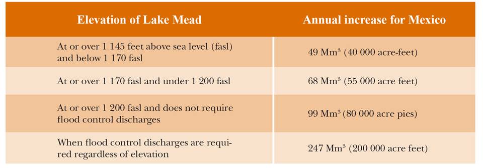
Source: Minute No. 319 Interim International Cooperative Measures in the Colorado River Basin (2012).
In the opposite direction, reductions are stipulated in cases of supply shortages. This issue causes concern mainly among farmers of the Mexicali Valley. Mentioned in the minute are the amounts of water that are no longer delivered to U.S. entities of the lower basin, and similarly, the reductions for Mexico are established. The figures are based on January 1st of each year, and reductions can be observed in Table 2.
Table 2: Annual reduction for Mexico, according to the elevation of Lake Mead
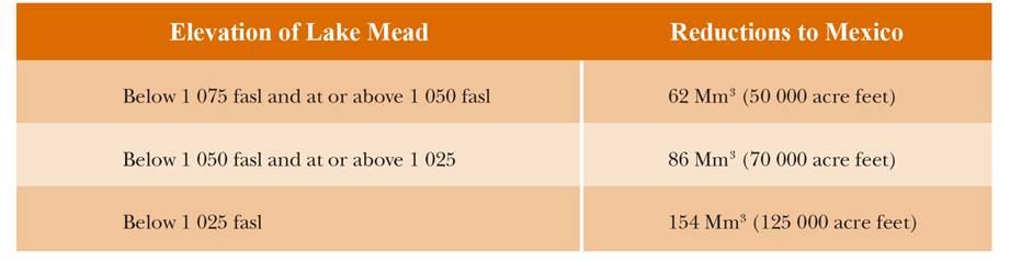
Source: Minute No. 319 Interim International Cooperative Measures in the Colorado River Basin (2012).
In this way, and without the formal approval of both countries' senates, the table of deliveries, defined in direct relation to the Hoover Dam storage, was modified. While the temporary nature of Minute 319 is repeatedly mentioned in its contents, this is not sufficient for farming sectors that see it as a violation of Mexico's rights by the United States. As we already observed, the 1944 treaty foresaw reductions due to consumption, not flow rate. It is among the points that have sparked controversy, given the way in which “extreme drought” is interpreted, as noted at the beginning of this article.
On the other hand, in the agreement signed in Minute 319, the concept of Intentionally Created Mexican Allocation (ICMA) appears. This concept allows the country to have a reserve in Lake Mead in the event that it should need it before 2018. In the event that Mexico does not need this reserve, it can sell it in the U.S. water transfer market, which has been in operation for several decades. California in particular is perhaps the entity that, since the 1970s, has generated the largest number of agreements for carrying out transfers (Bauer, 2010).
Preventing a Dry Future. Conceptual Change Regarding the Meaning of Historical Variability
In this article, we have proposed that the issue of flow rate variability has persisted since the beginning of the 20th century. Is current variability an effect of climate change or the result of evaporation in dams and extractions that eliminate return flows? As noted above, 68 years ago, Parsons (1950) observed the over-allocation of the Colorado River. The discourse on climate change has permeated many decisions and has generated a large number of proposals and changes in future scenarios.
In March of 2014, Sally Jewell, Secretary of the U.S. Department of the Interior, and Juan José Guerra, Mexico's Secretary of the Environment, issued declarations regarding the virtues of Minute 319. In these declarations, they related the changes in Mexico's water allocation described here to the benefits of the document with regard to the flow that will allow for the restoration of areas of the Colorado River's lower Delta (Jewell & Guerra, 2014). These authorities indicated that “…the Mexican and United States governments have learned about the limits and flow variability of the Colorado River. For this reason, we are convinced that cooperation is the best way to confront these challenges” (Jewell & Guerra, 2014, par. 7).
In the note, it would appear that the issue of variability is something that we learned about recently, whereas in reality -the main argument of this article- knowledge of it has existed for more than a century, and at different times, it has been the central point in debates concerning possibilities of the current's future use. Furthermore, while some authorities indicated that the 1944 treaty did change, others affirmed the opposite: there had been no change (Bono, 2012). Regarding the issue of concern here, we note that this point remains vague and that, in the minute, the 1944 treaty is cited as a principle reference. Additionally, it is explicitly noted that the minute is not a precedent for future agreements. In other words, with the exception of the minute's extension, the international treaty is what will be fulfilled, this being in the interest of both parties. In this sense, in our reading of the minute, there is the possibility of maintaining the agreement regarding the height of the Hoover Dam until 2026.
To Conclude
With the above analysis, it is not our intention to add to arguments that negate climate change (McCright & Dunlap, 2000). Our position is not one of calling into question this socially constructed global phenomenon. We only indicate that the variability of the Colorado River is a factor that has been studied and recognized since it became the focus of research at the beginning of the 20th century.
Approximately 60 million people depend upon the resource of two international rivers between Mexico and the United States, the Colorado River and the Rio Grande (others exist that we do not mention here). Here, we only address the case of the Colorado River, which involves approximately 40 million inhabitants. While other issues might be higher on the bilateral agenda, such as immigration or drug trafficking, the issue of possible conflicts over water persists, and the question remains: At what point could the river be substantially modified by climate change? For our part, we indicate that variability has been extensive in certain periods and not only as an effect of climate change.
Minute 319 is a preventative measure within a framework in which measures to address climate change is the discourse with the greatest impact. Therefore, it appears that the arguments used are a solution to a new problem or condition: the variability of the Colorado River. Nonetheless, this condition is a long-term issue that has appeared repeatedly.
REFERENCES
Adler, R. W. (2008). Revisiting the Colorado River Compact: Time for a Change? Journal of Natural Resources & Environmental Law, 28(1), 19-47. [ Links ]
Arellano, L. (13 de febrero de 2013). Combaten agricultores acta 319; se manifiestan en Mexicali [Mensaje en un blog]. Uniradio Informa. Recuperado de http://www.uniradioinforma.com/noticias/bajacalifornia/174003/combaten-agricultores-acta-319-se-manifiestan-en-mexicali.html [ Links ]
Barnett, T., Malone, R., Peneell, W., Stammer, D., Stammer, B. y Washington, W. (2004). The Effects of Climate Change on Water Resources in the West: Introduction and Overview. Climatic Change, 62(1-3), 1-11. doi:10.1023/B:CLIM.0000013695.21726.b8 [ Links ]
Bauer, C. J. (2010). El abanico de bancos de agua en las Américas. Estudios de Economía Aplicada, 28(2), 227-236. [ Links ]
Birdsong, B. C. (2011). Mapping the Human Right to Water on the Colorado River. Willamette Law Review, 48(117), 117-146. [ Links ]
Blanchard, R. (1924). Geographical Conditions of Water Power Development. The Geographical Review, XIV(1), 88-97. [ Links ]
Bono, R. M. (10 de diciembre de 2012). Minute 319: A Creative Approach to Modifying Mexico-U.S. Hydro-Relations Over the Colorado River [Mensaje de un blog]. Recuperado de http://www.internationalwaterlaw.org/blog/2012/12/10/minute-319 [ Links ]
Bureau of Reclamation. (1946). The Colorado River. A natural menace becomes a national resource. A comprehensive report on the development of water resources of the Colorado river basin for irrigation, power production, and other beneficial uses in Arizona, California, Colorado, Nevada, New Mexico, Utah, and Wyoming. Estados Unidos de América: Department of Interior, the Bureau of Reclamation. [ Links ]
Christensen, N. y Lettenmaier, D. P. (2006). A Multimodel Ensemble Approach to Assessment of Climate Change Impacts on the Hydrology and Water Resources of the Colorado River Basin. Hydrology and Earth System Sciences, (11), 1417-1434. [ Links ]
Colorado River Commission. (11 de noviembre de 1922). Minutes of the Eleventh Meeting. Santa Fe, Nuevo México, Estados Unidos de América. [ Links ]
Conway, C. J., Nadeau, C. P. y Piest, L. (2010). Fire Helps Restore Natural Disturbance Regime to Benefit Rare and Endangered Marsh Birds Endemic to the Colorado River. Ecological Applications, 20(7), 2024-2035. [ Links ]
Cook, B. I., Ault, T. R. y Smerdon, J. E. (2015). Unprecedented 21st Century Drought Risk in the American Southwest and Central Plains. Science Advances, 1(1), 1-7. doi: 10.1126/sciadv.1400082 [ Links ]
Cortez, A., Whiteford, S. y Chávez, M. (Coords.). (2005). Seguridad, agua y desarrollo. El futuro de la frontera México-Estados Unidos. Baja California, México: El Colegio de la Frontera Norte, Michigan State University. [ Links ]
Cruz-Castillo, M. (Abril de 2002). Catálogo de las fallas regionales activas en el norte de la Baja California, México. Geos, Unión Geofísica Mexicana, 37-42. [ Links ]
Enríquez, E. (1976). El tratado entre México y los Estados Unidos de América sobre ríos internacionales. Una lucha nacional de noventa años. México: Facultad de Ciencias Políticas y Sociales-Universidad Nacional Autónoma de México. [ Links ]
Fahlund, A., Choy, M. L. J. y Szeptycki, L. (2014). Water in the West. California Journal of Politics and Policy. doi:10.1515/cjpp-2013-0043, pp.1-42 [ Links ]
Farmer, J. (1996). Glen Canyon and the Persistence of Wilderness. The Western Historical Quarterly, 27(2), 210-222. [ Links ]
Forman frente común en defensa del agua del valle de Mexicali [Mensaje en un blog]. (16 de enero de 2013). Uniradio Informa. Recuperado de http://www.uniradioinforma.com/noticias/bajacalifornia/169229/forman-frente-comun-en-defensa-del-agua-del-valle-de-mexicali.html [ Links ]
Fox, J. (27 de abril de 2015). William Shatner's California Pipe Dream. Sending Washington's Water to California is DOA. Blomberg View. Recuperado de https://www.bloomberg.com/view/articles/2015-04-27/william-shatner-s-california-pipe-dream [ Links ]
Glenn, E. P., Felger, R. S., Burquez, A. y Turner, D. S. (1992). Cienega de Santa Clara: Endangered Wetland in the Colorado River Delta, Sonora, Mexico. Natural Resources Journal, (32), 817-824. [ Links ]
Glenn, E. P., Garcia-Hernandez, J., Congdon, C., y Luecke, D. (1999). Status of Wetlands Supported by Agricultural Drainage Water in the Colorado River Delta, Mexico. Horticultural Science, 34(1), 16-21. [ Links ]
Glenn, E. P., Lee, C., Felger, R., y Zengel, S. (1996). Effects of Water Management on the Wetlands of the Colorado River Delta, Mexico. Conservation Biology, 10(4), 1175-1186. [ Links ]
Glenn, E., Tanner, R., Mendez, S., Kehret, T., Moore, D., Garcia, J., y Valdés, C. (1998). Growth Rates, Salt Tolerance and Water Use Characteristics of Native and Invasive Riparian Plants from the Delta of the Colorado River, Mexico. Journal of Arid Environments, 40(3), 281-294. [ Links ]
Gray, L. C. (1913). The Economic Possibilities of Conservation. The Quarterly Journal of Economics, 27(3), 497-518. [ Links ]
Haro, S. (1 de enero de 2017). Revive discusión por el agua. Semanario Zeta. Recuperado de http://zetatijuana.com/2017/01/01/revive-discusion-por-el-agua/ [ Links ]
Harvey, M. W. T. (1991). Echo Park, Glen Canyon, and the Postwar Wilderness Movement. Pacific Historical Review, 60(1), 43-67. [ Links ]
Hicks, W. (2007). Columbia River Diversion as a Public Revenue Source. (White paper). Recuperado de http://aquadoc.typepad.com/waterwired/files/Columbia_River_Revenue.pdf [ Links ]
Hundley, N. C. Jr. (1963). The Dividing Waters: Mexican-American Controversies Over the Waters of the Colorado River and The Rio Grande, 1880-1960. California, Estados Unidos de América: University of California. [ Links ]
______ (1975). Water and the West. The Colorado River Compact and the Politics of Water in the American West. California, Estados Unidos de América: University of California Press. [ Links ]
Jewell, S. y Guerra, J. L. (31 de marzo de 2014). México y Estados Unidos, colaboración en el río Colorado. Milenio. Recuperado de http://www.milenio.com/firmas/sally_jewell_y_juan_jose_guerra_abud_sally_jewell_y_juan_jose_guerra_abud/Mexico-Unidos-colaboracion-rio-Colorado_18_272552781.html [ Links ]
Kelly, B. (3 de agosto de 2015). Drought relief, by rail. Railway Age. Recuperado de http://www.railwayage.com/index.php/freight/class-i/drought-relief-by-rail.html [ Links ]
La Rue, E. C. (1916). Colorado River and its Utilization (Water Supply Paper No. 395). Department of Interior, United States Geological Survey, Government Printing Office, Washington, Estados Unidos de América. [ Links ]
______ (1925). Water, Power and Flood Control, of Colorado River Below Grenn River, Utah (Water Supply Paper No. 556). Department of Interior, United States Geological Survey Goverment Printing Office, Washington, Estados Unidos de América. [ Links ]
Luecke, D., Pitt, J., Congdon, C., Glenn, E., Valdés-Casillas, C. y Briggs, M. (1999). El delta una vez más: restaurando el hábitat ribereño y los humedales del delta del río Colorado. Washington, Distrito de Columbia, Estados Unidos de América: Enviromental Defense. [ Links ]
McCright, M. y Dunlap, R. (2000). Challenging Global Warming as a Social Problem: An Analysis of the Conservative Movement's Counter-Claims. Social Problems, 47(4), 499-522. [ Links ]
Muñoz, P. (18 de agosto de 2015). E. U. usufructúa agua del Valle de Mexicali: CCC. La jornada. Recuperado de http://www.jornada.unam.mx/2015/08/18/sociedad/038n2soc [ Links ]
Nowak, K., Hoerling, M., Rajagopalan, B. y Zagona, E. (2012). Colorado River Basin Hydroclimatic Variability. Journal of Climate, 25(12), 4389-4403. [ Links ]
Olson, R. L. (1926). The Colorado River Compact (tesis de doctorado). Estados Unidos de América: Harvard University. [ Links ]
Overpeck, J., Garfin, G., Jardine, A., Busch, D. E., Cayan, D., Dettinger, M. … y Udall, B. (2013). Summary for Decision Makers. En G. Garfin, A. Jardine, R. Merideth, M. Black, y S. LeRoy (Eds.), Assessment of Climate Change in the Southwest United States: A Report Prepared for the National Climate Assessment, (pp. 1-20). Washington, Distrito de Columbia, Estados Unidos de América: Island Press. [ Links ]
Parsons, M. B. (1950). Party and Pressure Politics in Arizona's Opposition to Colorado River Development. Pacific Historical Review, 19(1), 47-58. [ Links ]
Robison, J., Bratrschovsky, K., Latcham, J., Morris, E., Palmer, V. y Villanueva, A. (2014). Challenge and response in the Colorado River Basin. Water Policy, 16(s1), 12-57. [ Links ]
Samaniego, M. A. (2006). Ríos internacionales entre México y Estados Unidos. Los tratados de 1906 y 1944. México: El Colegio de México, Universidad Autónoma de Baja California. [ Links ]
______ (2015). Usos sociales del agua y medio ambiente en la cuenca internacional del río Colorado, Región y Sociedad, (63), 61-96. [ Links ]
Sánchez, V. (2005). La demanda de agua en la región fronteriza México-Estados Unidos y los desafíos institucionales. En M. Chávez, S. Whiteford y A. A. Cortez (Coords.), Seguridad, agua y desarrollo. El futuro de la frontera México-Estados Unidos. México: El Colegio de la Frontera Norte. [ Links ]
Seavey, C. L. (1928). What the Boulder Dam Project Means to California and to the Nation. Annals of the American Academy of Political and Social Science, 135(1), 127-132. [ Links ]
Shor, G. G. Jr., Russell, W. R. y McGowan, D. D. (1976). Seismic Refractation Studies in the Southern California Borderland 1949-1974. Estados Unidos de América: University of California, San Diego Marine Physical Laboratory on the Scripps Institution of Oceanography. [ Links ]
Simon, S. (4 de mayo de 1990). Hahn Calls for an Aqueduct to the Northwest. Los Angeles Times. Recuperado de http://articles.latimes.com/1990-05-04/local/me-181_1_columbia-river-water [ Links ]
Smith, T. G. (1995). John Kennedy, Stewart Udall, and New Frontier Conservation. Pacific Historical Review, 64(3), 329-362. [ Links ]
Squillace, M. (2012). Water Transfers for a Changing Climate (Working Paper Number 12-02). Estados Unidos de América: University of Colorado Law School. [ Links ]
Valdés-Casillas, C., Hinojosa-Huerta, O., Munoz-Viveros, M., Zamora-Arroyo, F., Carrillo-Guerrero, Y., Delgado-Garcia, S. … y Luecke, D. (1998). Information Database and Local Outreach Program for the Restoration of the Hardy River Wetlands, Lower Colorado River Delta, Baja California and Sonora, Mexico. México: Instituto Tecnológico y de Estudios Superiores de Monterrey. [ Links ]
Work, H. (1925). [Hubert Work, Secretario del Interior a Frank B. Kellog, Secretario de Estado]. National Archives (Record group 115, entry 7, caja 36 032.5), Denver, Colorado, Estados Unidos de América. [ Links ]
REFERENCES
Arizona vs California, 207 U.S. 564 (1963). [ Links ]
Arizona vs California, 373 U.S. 546 (1963). [ Links ]
Boletín 1398. Pide senado proveer de suficiente agua de riego a campesinos del valle de Mexicali, 18 de abril de 2013. Recuperado de http://comunicacion.senado.gob.mx/index.php/informacion/boletines/6554-boletin-1398-pide-senado-proveer-de-suficiente-agua-de-riego-a-campesinos-del-valle-de-mexicali.html [ Links ]
Boulder Canyon Reclamation Project. 1926. Committee on irrigation and reclamation, report 3331, rep. 654, part 1 [Senate 66 congress]. [ Links ]
Colorado River Development. Colorado River investigations water storage and power development Grand Canyon to the Imperial Valley 1928, 70 congress session, documento 180, [Senado de los Estados Unidos, Goverment Printing Office]. [ Links ]
Dictamen de acuerdo del congreso del estado de Baja California por el que se exhorta a la celebración de una mesa de trabajo en relación con la firma del acta 319 entre México y Estados Unidos. 9 de abril de 2013. Recuperado de http://sil.gobernacion.gob.mx/Archivos/Documentos/2013/04/asun_2967003_20130416_1366122205.pdf [ Links ]
Hearings before the subcomitte on irrigation and reclamation, H.R. 4671 and similar bills to authorize the construction, operation, and maintenance of the lower Colorado River basin Project [89 congress, Senado de los Estados Unidos]. Agosto-septiembre de 1965. [ Links ]
Hearings before the subcomitte on irrigation and reclamation, H.R. 3300 and similar bills to authorize the construction, operation, and maintenance of the lower Colorado River basin Project. [90 congress, Senado de los Estados Unidos]. Marzo de 1967. [ Links ]
Minute No. 317 Conceptual Framework for U.S.-Mexico Discussions on Colorado River Cooperate Actions, International Boundary and Water Comission. United States and México. 17 de junio de 2010. Recuperado de https://www.ibwc.gov/Files/Minutes/Minute_317.pdf [ Links ]
Minute No. 318 Adjustment of Delivery Schedules for Water Alloted to Mexico for the Years 2010 Through 2013 as a Result of Infraestructure Damage in Irrigation District 014, Rio Colorado, Caused by the April 2010 Earthquake in the Mexicali Valley, Baja California. International Boundary and Water Comission. United States and México. 17 de diciembre de 2010. Recuperado de https://www.ibwc.gov/Files/Minutes/Min_318.pdf [ Links ]
Minute No. 319 Interim International Cooperative Measures in the Colorado River Basin Through 2017 and Extension of Minute 318 Cooperative Measures to Adress the Continued Efects of the April 2010 Earthquake in the Mexicali Valley, Baja California, International Boundary and Water Comission. United States and México. 20 de noviembre de 2012. Recuperado de https://www.ibwc.gov/Files/Minutes/Minute_319.pdf [ Links ]
Minute No. 319 of the International Boundary and Water Comission, United States of America and Mexico. Boundary Waters. Threaties and Other International Acts Series 12-1127. [Department of State]. 20 de Noviembre de 2012. Recuperado de https://www.state.gov/documents/organization/205768.pdf [ Links ]
National Archives Denver, Record Group 115, caja 27 64 B. Denver, Colorado, Estados Unidos de América. [ Links ]
Water Treaty with Mexico 1945 [Comité de Relaciones Exteriores del Senado de los Estados Unidos, Government Printing Office]. [ Links ]
1The Santa Fe pact is the division made to distribute the resources of the Colorado River. This pact unofficially granted a certain amount of water to Mexico.
2In Owens Valley and Mono Lake, water rights were bought to supply Los Angeles, using an aqueduct. In the case of Owens Valley, this meant a transformation of farming and livestock activities. The farmers’ resistance movement had significant high points in the 1920s.
3The National Archives, Record Group 115 (in Denver) contains numerous documents in which California organizations request that water concessions not be granted to upper basin entities such as Colorado, Wyoming, Utah and New Mexico.
4The method is also known as dendrochronology. To explain briefly, we note that interpretations of droughts or periods of water abundance, among other things, are made based on rings in tree trunks. The development of this area of science began in the 19th century and has therefore been applied for more than a century.
5This is an international river, originating in Canada and descending into the United States. The basin states are Washington, Oregon and Idaho. Some tributaries flow into Montana, Wyoming, Utah and Nevada. It is the most abundant river in the United States and empties into the Pacific Ocean.
7During the same years, the issue known as “the salinity of the Colorado River” emerged, generating a number of differences with Mexico. Regarding this, in this article, we only note that the issue requires a more detailed analysis, as it must be clarified that this was not river water but groundwater from Wellton-Mohawk.
8Based on studies of U.S. scientist Charles Kelling (1928-2005), the first discussions of climate change appeared, although the term itself did not come into use until 1979. Kelling conducted the first measurements of carbon dioxide (CO2) in 1958 at the Mauna Loa Observatory, located on the peak of a dormant volcano in Hawaii.
Received: May 23, 2016; Accepted: May 17, 2017
 Este es un artículo publicado en acceso abierto bajo una licencia Creative Commons
