


Servicios Personalizados
Revista
Articulo
 texto en
  Inglés (pdf)
 Artículo en XML
 Referencias del artículo
 Enviar artículo por email
Indicadores
-
 Citado por SciELO
 -
 Accesos
Links relacionados
-
 Similares en
SciELO
Similares en
SciELO
Compartir

 Permalink
Estudios fronterizos
versión On-line ISSN 2395-9134versión impresa ISSN 0187-6961
Estud. front vol.17 no.34 Mexicali jul./dic. 2016
https://doi.org/10.21670/ref.2016.34.a07
Articles
Alexandra Colony: Resilience in the North of the province of Santa Fe (1866-1904), Argentina

1 Unidad de Investigación en Historia Regional (Ishir) y Consejo Nacional de Investigaciones Científicas y Técnicas (Conicet), Buenos Aires, Argentina, correo electrónico: dosztal@ishir-conicet.gov.ar
In this article the theoretical aspects are developed from a historic-anthropological perspective, which anticipates a frontier space with a differentiated economic, social and cultural structure, where they operate the life and experiences of families of settlers who are 90 km of the Northern territorial limit controlled by the Government of the province of Santa Fe. In the north border of Santa Fe the "desert" fights", first, with the foundation of agricultural colonies for contract and, then, with the military advance. Therefore, the concept of border of colonization is chosen to analyze the role of the colonies that make it up next to Alexandra Colony. Based on the review of the studies of border, focuses on the character resilient of social groups facing out of the last line of forts to the North of the province of Santa Fe, where the agricultural colonies were founded.
Keywords: border of colonization; resilience; official colonization; Province of Santa Fe
En este artículo se desarrollan los aspectos teóricos desde una perspectiva histórico-antropológica, que anticipa un espacio fronterizo con una diferenciada estructura económica, social y cultural, donde se desenvuelven la vida y experiencias de familias de colonos que se instalan a 90 km del límite territorial septentrional controlado por el gobierno de la Provincia de Santa Fe. En la frontera norte de Santa Fe se combate el "desierto", en primer lugar, con la fundación de colonias agrícolas por contrato y, luego, con el avance militar. Por lo que se elige el concepto de frontera de colonización para analizar el rol de las colonias que junto a Alexandra Colony la conforman. Partiendo de la revisión de los estudios de frontera, se focaliza en el carácter resiliente de los grupos sociales enfrentados por fuera de la última línea de fortines al norte de la Provincia de Santa Fe donde se fundan colonias agrícolas.
Palabras clave: frontera de colonización; resiliencia; colonización oficial; Provincia de Santa Fe
Introduction
In the second half of the nineteenth century, the Argentine State establishes a political, economic and social plan that allows it to enter the global market. This plan involves entering the age of capital. On the one hand, entering an economically and culturally alienating era enabled the expropriation of lands and the transculturation2 of a dispossessed and unreduced3 indigenous community that crossed and lived in the "desert." On the other hand, this era established the mechanisms of a modern capitalist agro-exporting society that contained the seeds of the establishment of institutions that have ruled Argentine society until today.
The border between whites and Indians-which in this context, no longer had a reason to exist-served simultaneously as a geographical and social boundary but was maintained as a permeable barrier. Although its goal was to maintain the difference between "civilization" and "barbarism," it could not prevent the various social groups from interacting, leading to a very complex organization of social and behavioral relationships.
The dichotomy that converts a group with an identity different from that established into the other implies the recognition of certain limitations and agreements required to reach a mutual (political, economic or sociocultural) understanding. In this case, however, the value judgments expressed by the dominant group led to the extermination of the other composed of different ethnic groups. This transformed the issue of the border's breakdown into a matter of State importance.
Given not only that this border was part of the political discourse but also that it materialized between the eighteenth and nineteenth centuries and left traces on the land it occupied and on its settlers, this paper reveals the peculiarities of a settlement boundary from a theoretical and practical perspective and that boundary's impact on the development of the colonies that (along with Alexandra Colony) were part of it.
This work is based on an analysis of theoretical assumptions that helped us understand the complexity of a settlement composed of foreigners on a territory that was inhabited by indigenous groups that resisted occupation. Next, this analysis helped delineate the particular characteristics of the case under study.
Before engaging in this theoretical development, this paper presents the conditions of the foundation of Alexandra Colony within the colonization project carried out by the successive governments in the province of Santa Fe during the period under study.
Alexandra Colony, its founding context
The London bank Thomson Bonar & Co., which is based in Buenos Aires, finances the Alexandra Colony colonization project. Through its name, the company pays tribute to the future queen consort, Alexandra of Denmark, the wife of King-Emperor Edward VII. Alexandra was popular and beloved among the British. Having a generous and charitable nature, she carried out her public duties in favor of disadvantaged classes (Hough, 1992). In addition, her post-accession beauty caught everybody's attention (Madol, 1940), and her clothing style set the fashion for over 50 years, including the use of a choker that covered the neck and neckline (Dosztal, 2015).
The colonization contract was approved by Governor Simón de Iriondo and delimited the property of 25 square miles alongside the San Javier River, establishing entrepreneurs' commitment to settle 400 families of European immigrants over five years. The area adjoins the property of Ovidio Warnes and Cía to the south and the Malabrigo Stream to the north. In the delineation of the colony, each settler family is assigned 25 square blocks that must be funded once the land has been granted (Wilcken, 1873).
In the preceding years, three colonies are founded-California, Welsh and Eloisa-on the territory extending from the northern line of forts (next to the indigenous village of San Javier) to the southern boundary of Alexandra Colony. Together they form a social, economic, ethnic, identity and political circle resulting from the profile of the population sought by the ruling class (Dosztal, 2013). These colonies are created within the scope of a program promoted by the provincial government known as official colonization, in which the State plays a key role in regulating and controlling contracts. In that regard:
Two types of colonization were mainly performed in the province of Santa Fe; one official and one private. The first one prevails in our area of interest: northern Santa Fe. In the official colonization, the State acted as an intermediary through land grants to entrepreneurs or colonizing companies (Dosztal, 2010, p.1517).
Public lands sold under this colonization system were purchased at minimal cost and entrepreneurs had to comply with some obligations related to the number of colonists that would settle, housing facilities, and the provision of seeds and tools to the settler and his family (Ensinck, 1978, Zeballos, 1984). To implement these requirements and trade their products, the State creates the so-called central administration's houses. They play a significant role, especially in this first stage of official colonization (1850-1870), when a few colonies were isolated in the vastness of the territory (Gallo, 2004).
The largest proportion of colonies is founded between 1870 and 1895 with a process called private colonization, in which the State's role undergoes a drastic shift in which it is limited to exempting entrepreneurs from paying direct contributions if the land is outside the border line; also exempted were those who would initiate commercial and industrial activities (Larguía, 1876). This drastic change in the system is associated with the fact that colonies were rapidly founded, overcoming their isolation and generating experienced settlers who transmitted their knowledge. Thus, the presence of the central administration's houses was no longer compatible with the lightness experienced from the 1880s (Gallo, 2004).
In 1871, Alexandra Colony suffers the ill effects of a confrontation with local indigenous people. Fifteen years later, the Thomson Bonar & Co. company decides to sell its property on the territory of Santa Fe. This foundational context conditions administrators and settlers, who are faced with the need to combine their daily occupations with the imposition of a defense role of a controversial character, in a territory that they were granted through the signature of colonization contracts. Therefore, it can be argued that Alexandra Colony must resist adverse social, economic, political and diplomatic situations. In this scenario, settlers play a central role because they are the ones who work to carry out the project. Therefore, they lodge their complaints of administrators' abuses to the Justice of the Peace (Tourn, 2001); they organize themselves to fight the common enemy (indigenous groups regardless of their ethnic differences); they allow the State to use lands that it does not officially control; and they devote the time necessary to organize the military occupation of the Chaco region. Although the great project of agricultural colonization fails, the combination of intensive agriculture and livestock with English colonialism allows, with the founding of Alexandra Colony, the control and exploitation of territory that was previously in the hands of native Guaycuru people from the region.
Studies on border areas: Background
Approaches from the 1970s until now addressed the border issue from a political and social perspective, as a space in constant interaction with the geographical, social and economic environment surrounding it and as a territorial boundary (Alemán, 1970 and 1981; Benedetti, 2007, Matthew, 1997; Ratto, 1996 and 2003; Weber, 1986).4 Therefore, a materialized entity was given to space and time from the moment social actors (lieutenants, commanders, chiefs, presidents and governors) defined a dominated-dominant relationship derived from incorporation into the global market.
This need for international links leads to finalization of the conquest of territories by the local bourgeoisie with the advance of civilization in both the South and the North of the country, between the last third of the nineteenth century and the early twentieth century. These conquests had various objectives, one of which was the expropriation of material and cultural conditions, defining the indigenous population as the dispossessed class. That is, the local bourgeoisie joins and lets the capitalist mode of production successively subsume preexisting work processes and trade relationships, attempting to re-functionalize them until the internal border is eliminated (Trinchero, 2007). "Historically, this process begins with the division of society into different strata and classes when, as the result of the development of productive forces, the dissolution and improvement of the primitive community occurs" (Iñigo, 1989, p. 2). Therefore, the study on life on the border enables an analysis of social classes and of their connections with the State.
The examination of the value of those times with the protagonists leads to considering how land, livestock and work had a role in the southern countryside, and what the State's capacity was, to mobilize and capture in favor of a class interest (Rocchietti, 2008, p. 103).
To make this possible, it is necessary to improve the simple character of the Argentine rural world, its backwardness and its barbarism through its incorporation into a system of capitalist relationships, completely altering land ownership, given that it opposed the rational right and the right of tradition; this right must come from the Nation State. This process can only be built "if it is linked to the process of military conquest and subjection of the indigenous population, when the time of transition for the development of the Argentine capitalism occurs" (Iñigo, 1989, p. 5). It changes the regional economy based on hunting, gathering, an incipient agriculture, and war "as an activity that helped obtain and maintain its main condition of production (land), and whose form of social organization was based on the tribe [...]" (Iñigo, 1989, p. 1).
The border area, which is understood from this convergent conception of multiple aspects, goes beyond the ecological scope and can be covered as a social issue between spaces characterized by heterogonous productive and reproductive dynamics. Therefore, the concepts of border and region were methodologically reconciled, given that both concepts recognize and reveal corporate and economic traits that imply human and material trade. The relationship between the border region and the central State hid intertwined stories. The border region became "an area of dynamic interrelationship between different societies, a border that in no way is an 'empty space'; but rather a space that tries to be occupied and that, in turn, is intermittently traversed and crossed" (Areces, 1999, p. 26).
In other words, the imaginary lines drawn by the State are not fixed; they are permanently crossed in everyday life in such a way that a range of inter-ethnic links is shaped. It is opposed to the Nation State's objective of territorial definition; the space it should have occupied and defended is delimited from a perspective that considers it as more than a boundary (between nation/desert, productive/unproductive or traditional/modern) (Trinchero, 2007). In this regard, the notion of border must be understood as spatial and territorial because "this is the institutionalization of the territorial boundaries of the State to which it is said to belong" (Areces, 2009, p.306).
Accordingly, it is essential to highlight the nuclear characteristic of its permeability, which transforms a geographical space into cultural ethnic boundaries, in a way that:
Sometimes, these can be very well defined, and sometimes they fail to be differentiated; rules may be strict and simple or tortuous and complex, and this richness of differentiation generally does not match and cannot actually do so, neither with boundaries of political units nor with will (Areces, 1999, p. 26).
This phenomenon was not symbolic. Instead, it is located in a historic region composed of the geographical context and its resources, productive activities and relationships with the market, population dynamics and the cores of power, identity and community as expressed through marriages and ethnic identification.
When approaching the border as a dynamic institution, local researchers (Areces, 1999, 2009; Banzato, 2009; Banzato and Lanteri, 2007; Iñigo, 1989; Rocchietti, 2008; Trinchero, 2000, 2007) consider the links between the different types of borders with neighboring societies that have defined their own space. The historical and social construction of this space and the relationships established between the societies that lived together while competing for the same place are retrieved.
The lands, which the State argues must urgently be populated, are called desert. "The interiority of the desert simultaneously consists of geographic reference, imaginary place (for whites), concrete antipode, of 'campaigns' that come to free it from its otherness, of emptying cultural illegality" (Rocchietti, 2008, p.42). Therefore, the border refers to an institution whose duration comprises the new social, political and cultural context; this institution becomes anachronistic and useless from the moment that Argentina and, consequently, the province of Santa Fe enter the global market.
Settlement boundary: an analysis of the proposal
Alexandra Colony is developed in the context of a settlement boundary (Dosztal, 2013; Trinchero, 2007), given that it is an agricultural colony submerged in a geographical environment that is socially wild, remote and desolate. This border occupies an "inhospitable," "barbarian" territory opposed to the "civilized" space that the hegemonic society dominated; however, the territory is coveted for its potential resources.
This settlement boundary is the result of the conjunction of the concepts of borderline and frontier used by Turner (1921), not isolated but as a dialectical interaction in the colonization processes. Borderline is defined as the formation of political boundaries between two nation-states, and frontier is defined as an indicator of expansive fronts, mainly agricultural structures (Trinchero, 2007). Thus, the border is a social space of institutionally endorsed violence that is historically shaped, where economic and political relationships are organized between multilingual and multicultural societies.
La Frontera (the Border) had complementary faces: it is a military and demographic organization at the same time. The other was Tierra Adentro (Inland), beyond political and cultural control. The military line demarcated the end of the validity of the Spanish laws and then of separate acts. Tierra Adentro described the mystery of the unknown-in the geographic sense-and the control over the tribal organization, the primitive as an allegory of the natural, the founding unit of the primitive, such as the noble and bad savage (Rocchietti, 2008, p. 34).
This connection between the concept of borderline and frontier helps address the occupation policy carried out between 1866-1904 as a colonizing expansive block (frontier) behind the line of forts that provided security to migrant populations, leaving them vulnerable to possible confrontations with indigenous groups that had not been reduced (Dosztal, 2013). Figure 1 represents the absence of an official defense near the area considered as a settlement boundary.

Note: This figure locates the area of the settlement boundary (in gray) and its relationship with the successive lines of forts. During the period from 1859 to 1870, during which the agricultural colonies were founded, the line of forts remained static, next to the indigenous village of San Javier. Thus, the immigrant population is exposed to situations of confrontations with indigenous populations who resisted occupation.
Figure 1: Modified plan taken from Spota (2009)
Nevertheless, the positive vision of this region among the ruling class of the 1860s and 1870s prevails over the settlers' safety, and settlements continue despite what is occurring. The German specialist Burmeister (1944) 5 considers that although the lands near the coast were suitable for the development of cereal crops, the lands of the Pampean region were not. Urbano de Iriondo (1876) ratified this view, stating that appropriate soil for such productive activity can be found north of the provincial capital: "where the Creator shows his magnificence and beauty [...] for the priceless wealth that he has profusely spilled in this truly privileged land" (Iriondo, 1876, p. 153). These studies had such an impact that colonization initiated west of the city of Santa Fe spread to the North. The fields covered with lush vegetation and woodlands delight those who face them:
My colleagues, mostly farmers from different parts of the United States, unanimously declared that they have never seen such a great extension [sic] of land so uniformly fertile [sic] such as the fields of Paraná between San Javier and el Rey, taken in relation to their capacity for agriculture and grazing (Perkins, 1867, p. 20).6
Two men of the so-called Generation of 37, future presidents of Argentina, Bartolomé Mitre (1862-1868) and Domingo Faustino Sarmiento (1868-1874), argue that the border area was empty,7 not of resources but of civilization. This "empty" space is filled with persistent European and American immigration, thus forming a border identity. As planned in the colonization process, the arrival of migrants8 from different backgrounds who would occupy those vacant lands and transform the natural and human landscape helped form the desired national character with the objective of integrating border-desert, one of the hindrances that had to be eliminated to control the formation of the emerging nation-state.
The settlement of this particular colony is valued and supported by the government of the province of Santa Fe, akin to the guidelines of national colonization policy. Accordingly, this settlement is seen as the gateway to spontaneous colonization of the region, enabling a series of contracts between the provincial government, independent settlers and colonizing companies, establishing the conditions for the settlement of immigrants behind the border line.
Thus, the border constitutes a geographical and historical space in which opposite economic, social and political relationships are articulated. In this context, civilization and barbarism contradict one another in the context of the development of their own projects of social and cultural existence (Rocchietti, 2008). In this space, a new identity is built, converting immigrants from various backgrounds into Argentineans and from Argentina into their homeland. These rent-free lands are the driving force of a social mobility that is impossible in Europe (Turner, 1921). These pioneers transform the space by establishing a new social, cultural and geographical system-i.e., they incorporate it into a class society. The social dynamics introduced at the border of northern Santa Fe combines the establishment of colonies and survival in the territory while forging the democratic character and institutions that rule the rest of the territory controlled by the State.
In this context, it is urgent to solve the indigenous issue, and a three-stage treatment arises. In the first stage, from 1854-1885, the (military and political) strategy is defensive-offensive; in the second stage, from 1885-1911, a process of subjection and colonization occurs; in the third stage, there are various levels of political debate, from 1904-1911, and from that year to 1921, there is an attempt to engage in redress policy (Rocchietti, 2008).
The defensive-offensive period includes the methodical drawing of the line, i.e., the direct and systematic intervention of the state military forces in the construction of the border, the protection of properties and lives, and the rescue of prisoners (given their Argentinean status). Funds are provided to stabilize the area; areas considered as strategic are occupied, others are explored (especially rivers considered as natural boundaries with Indians), and villages are founded.
Control is operated by the army, which as a military corporation (Trinchero, 2007) begins to play a multiple and hegemonic role committed to bringing stability to the border.
The subjection and colonization process is carried out through the expropriation of the material conditions of existence of the indigenous population. A monopoly on the use of force is carried out to build a working class that is coherent with the production system being implemented (Iñigo, 1984).
Indigenous people are integrated into society itself, provided they embrace civilized life; indeed, they have no alternative but to accept its uses, forms, rules and morals because precarious employees were prevented from establishing themselves as a permanent workforce. "This objective entailed canceling the tribal organization of the Aborigines, erasing their customs and even their languages, educating their children and generally turning them into productive workers, as an ineluctable price to grant them rights of citizenship" (Quijada, 2000, p. 70).
In the conquest of the Chaco of Santa Fe,9 the provincial government's initiatives are enhanced by settlers' private efforts to expel Indian populations. The government itself continues to contribute input for conducting expeditions to the "desert"10 that attempt to retrieve cattle and prisoners. These depredations are seen by settlers as attacks on their property, understanding that this is how justice is done. These policies of civilization advance and progress-in the hands of immigrants from different backgrounds, organizing themselves and resisting the other, the stranger-help the State form a defensive and expansive cordon that is defined as a settlement boundary.
Settlement boundary in the North of Santa Fe
The settlement boundary under study reaches its natural boundaries at the Saladillo Dulce y Amargo and San Javier rivers, between the Parana River and the Gran Chaco. These are public lands that stretch from the village of San Javier to el Rey Stream, with an extension of 180 km. This boundary is located between two former Jesuit reductions: one of Mocovies in the South and one of Abipones in the North. The area called Pájaro Blanco (White Bird), which is a name granted for the abundant presence in their woodlands of herons, with a black peak and white body-90 km away at both ends, forms the area in which fields of better agricultural-production quality stretch, where reduced peasants are allowed to hunt, and where "there was no danger anymore" (Perkins, 1867, p. 49) (Figure 2).
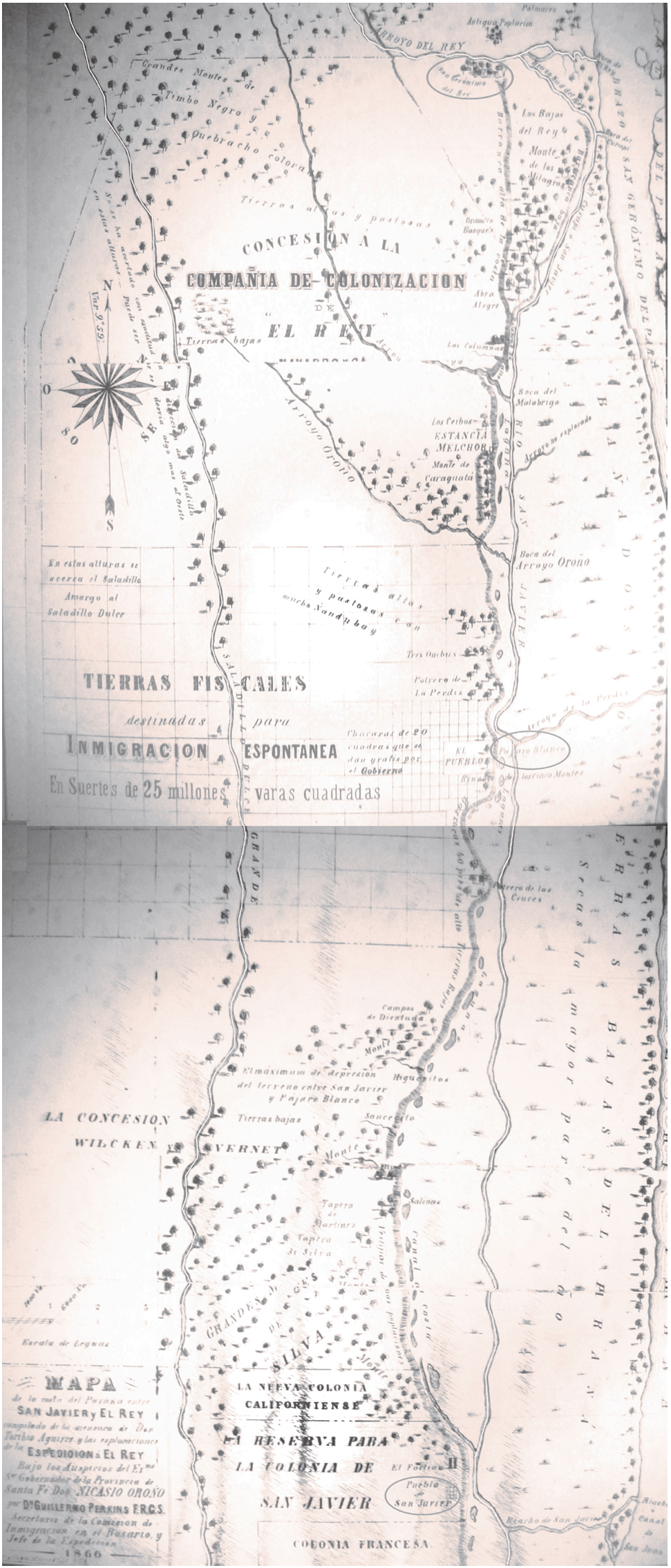
Note: The map shows the boundaries formed by two former Jesuit reductions, one of indigenous Mocovies in the South and one of Abipones in the North, and the area of greater environmental quality where Alexandra Colony will be established.
Figure 2: Geographical and historical location of the settlement boundary (Perkins 1867)
Through a review of the events experienced by the first European and American settlers in this region, it can be confirmed that the area of these settlements was tacitly a peace zone where different-both wild and reduced-indigenous groups could hunt without restrictions. However, this agreement did not include the new immigrant population, so the consequences were narrated in official reports, epistles, journals and field diaries.
In this area, settlements are successively founded and established before the lands are incorporated into the territory controlled by the provincial government. This process is part of a unit of social organization of space that proposes a new form of settlement, new economic and social structures, new forms of power and ultimately, a new system of values (Areces 1999). This new land tenure, i.e., the state's laws on public land sale, rental, lease or distribution, provides another landscape, social and economic character to the region.
This same region has weak official protection, given the poorly equipped and erected forts scattered throughout the foreign-occupied territory do not generate the conditions for achieving territorial and disciplinary control over the indigenous population. This situation led members of the administration and settlers to defend themselves from attacks from the indigenous resistance that challenged the occupation of their territories. These types of confrontations often occurred over a period of time, resulting in the development of resources in social groups that helped them overcome their adverse situations (Schiera, 2005). In this environment, for example, settlers repeatedly helped the commander of the fort located between California and San Javier. Once, the fort was surrounded by the chief and a group of Indians who protested that two of their men had been unfairly accused of killing visitors. Initially, the Californian William T. Moore mediated between the groups. Because he did not succeed, there was a confrontation that ended with the death of several indigenous people and most of their group escaping to the woodlands (Vogel, 1946).
The objectives of these attacks are generally cattle and horses; deaths are often unintentional. For example, whereas California Colony suffers successive thefts, their neighbors from Eloisa Colony live quietly, working the land, orchards, vineyards and crops until they suffer their first attack in May 1871, one year after they combined production with livestock and during which three settlers die and a child is kidnapped (Vogel, 1946).
Two months after his arrival to the lands of Santa Fe, after managing land surveying before the immigrants' arrival (which begins but does not end), land surveyor Edwin A. Hudson, says, "I come to willingly relinquish the position entrusted to me, in order to carry out this surveying, expressing to [sic] these gentlemen the utmost gratitude [sic] for relieving me from such an unpleasant obligation" (Hudson, 1870, p. 12). This surveying was unfinished because of the successive attacks of local indigenous groups, which become daily attacks during their most intense period, as detailed by Andrew Weguelin in a January 1871 letter: "in view of all this, I have come to the conclusion that, as it would be impossible to do any work safely with no less than a hundred men, we should leave the colony and send all men home" (Weguelin, 1871).11 Land surveyor Cayetano Livi, who surveyed, defined and marked the boundary of the entire field for the period from March to June 1871, arrived at the same conclusion.
These events occurred even after the shift of the border by Reconquista in 1872. The response to these events is recorded in various documents. Some reports sent to the government describing the day-to-day experience of expeditions against the wild Indians led by W. T. Moore can be highlighted. The first expedition takes place after the invasion of Romang Colony, located north of Alexandra Colony, at the end of June 1875. The village is looted and burned, neighbors die during the attack and two children are taken captive.
The expedition has the support of the provincial government of Servando Bayo. On July 3, 1875, 25 male volunteers from California, Alexandra and Romang colonies travel into the woodland to eliminate the common enemy.
The expedition is interrupted because of a lack of water, but the expedition members return with some benefit:
17 dead Indians whose death is certain, and a large number who will undoubtedly die of their wounds; three boys taken prisoner; 17 sheep, all eaten on the road, 3 dairy cows brought from Malabrigo; 26 retaken horses. A lot of curiosities were also brought and among other things, finger bones that were used as buttons. In the little village of Indians, we found herbs, ground coffee, sugar and lots of cooking utensils made of cast iron and beaten iron, etc. In the opinion of our chief Don Guillermo Moore, this is due to the existence of friendly relationships with Indians from el Rey (Grobet, 1875, p. 3).
In September of the same year, a new incursion occurs, with supplies provided by the government; it extends from Thursday, September 2, through Tuesday, October 5. Daily activities were reported by Juan Grobet in a diary of the march. During that period, the group attacked an Indian village and killed three Indians; a group of women and children were captured and taken to the camp. The captives indicate the nearby presence of the Tobas, who have many properties. However, because that group never attacks the colonies, the colonists decide not to act. Muggings are always ascribed to Juan Gregory, former chief of the indigenous populations of San Javier, who escapes from Martín García.
A few days before their return, the colonies suffer another misfortune. William Henry Moore (who is Captain Moore's son and justice of the peace in Alexandra Colony) and his director, Arthur L. Powys, die in an ambush. They leave, together with peon Pío García and James R. Holman, to punish a group of Indians who had stolen horses from the administration's stables but are surprised by a group that outnumbers them (Tourn, 2001). The repercussions were immediate: another authorized expedition is held in November. The procedure was the same as always, but this time, a greater number of Indians is killed and 61 prisoners are captured.
After the death of his son, William T. Moore returns to the United States in July 1877, and his brother, Benjamin L. Moore, continues to lead punitive expeditions to curb Indian attacks, which became more sporadic by the end of the decade because of the northwards advance of the line of forts, the strengthening of Reconquista as a defense front, and the military conquest of the Chaco undertaken by the national government in 1884 (Maffucci, 2007).
These campaigns conducted by settlers are well received by the rulers but rejected by staff officers who are responsible for the border protection because they see their work discredited. However, the desertion of troops occurs between 1872 and 1884 because of the continuing economic difficulties that resulted in the impossibility of mobilizing troops to cover the line of forts and transmit information about possible Indian attacks or advances beyond the 28th parallel. Their mission of advancing through a successive occupation of the territory could not be advanced, resulting in "a subsidiary force in private initiatives undertaken by European settlers who carried out armed incursions against Aboriginal people" (Brac, 2009, p.77).
Thus, the concepts of attack and defense are blurred according to the side of the border on which the protagonists are located. In the coexisting resistances, which lasted nearly half a century, two country projects were confronted because the various government interventions enabled the triumph of civilization, eradicating the various indigenous groups from the lands where they were born and had lived for generations.
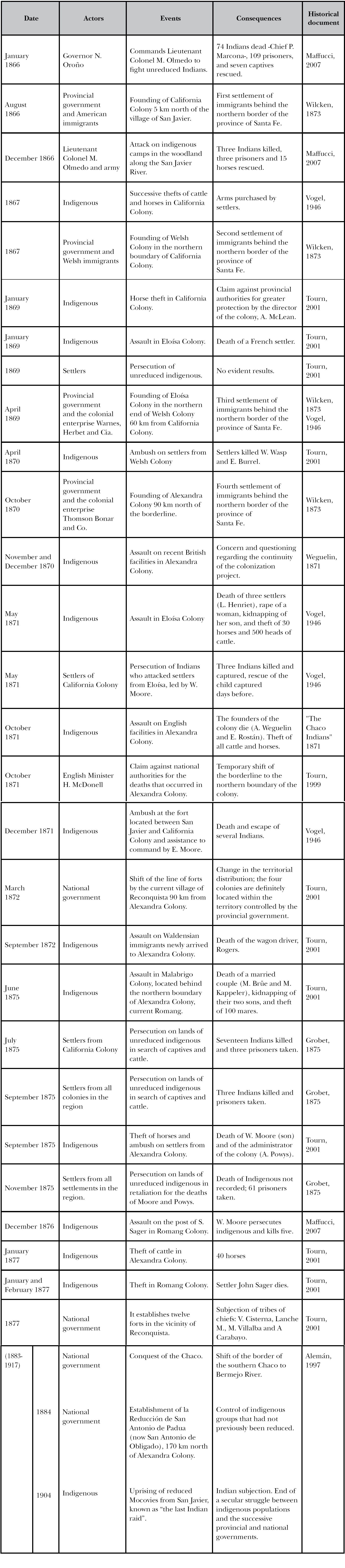
Table 1 summarizes the resilient nature surrounding these confrontations from 1866 (the year that California Colony was founded) to 1904 (the year of the last Mocovi uprising, immortalized in history as "the last Malón (Indian raid)") (Table 1). Table 1 shows three protagonists: the State and its institutions, settlers and indigenous groups. This resilient character is observed both in the second and the third component, whereas the State is presented as a guarantor and promoter of an expansionist policy that promoted the production of capital for export, ignoring the native population and its culture and actually seeking to resolve the indigenous issue.
Table 1: Evidence of the resilient character in the southern Chaco of Santa Fe, diagram according to the role of each opposing group
The extension of the policy of military advance on the Chaco of Santa Fe, as a security guarantee in the daily life of the colonies in the region, transforms Alexandra Colony in the late nineteenth century into a center of commercial and residential attraction for inhabitants of the neighboring settlements, whose planned progress is impossible given the above conditions. These colonies became desolate places, witnessing a colonization policy cut short by the reality of the region itself, which is ignored by successive provincial and national governments.
Over the years, Alexandra's urban area, which was composed of fourteen houses, became the center for the purchase and sale of livestock in the region. Far from the progress attributed to its fertile lands, abundant water, woodlands and capital invested, Alexandra Colony did not become a model project that, if imitated in the region, would have become a thriving center of civilization. Local historiography called Alexandra the "mother of colonies" (Tourn, 2001) given that the dispersion of the population, after its sale in 1885, provided new settlements a few kilometers away-e.g., Florence, Calchaquí, Reconquista in Santa Fe and Colonia Valdense in Uruguay-with experienced farmers with the knowledge to work the land.
Final words
At the dawn of the border society, it had low productivity. For that reason, the expropriation of native societies' land (to incorporate that land into the territory controlled by the Nation-State and to exploit the natives by settler families) helped the ruling class guide Argentina's access to the capitalist production system.
California, Welsh, Eloisa and Alexandra colonies witnessed this process by synthesizing in them all of the developments and progress described in historical documents without scrimping on qualifications. Changes in work habits, food production and consumption transformed the vast and unpopulated lands of the province of Santa Fe into a Europeanized space.
In the second half of the nineteenth century, the northern border of the province of Santa Fe was a geographical environment characterized by violence; political, economic and social interests were disputed there. Accordingly, the context in which the colonization project of Alexandra Colony is developed was one of successive struggles and uncertainties, similar to other borders of the Argentine Republic. The main difference was that defense of the territory was left to immigrant settlers, not the army. Characterized by strong militarization, the settlers established a paramilitary force that reinforced the protection of a fragile border.
In short, this approach to regional history shows direct connection with provincial and national history; the local history of each of these colonies goes beyond a mere description of events that give way to the construction of social identities in the relevant territory (Fernández, 2007). In this context, the sense of belonging created tense relationships with the other, who consisted of peoples of the linguistic Guaycuru family, groups of Abipones and Mocovies who had previously inhabited the same piece of land. This was a negative link that highlighted identity distinctiveness in a particular space and time.
Wiring, agricultural machinery, and the cultivation of cereals and tobacco by the new and growing rural population fought the desert, witnessing the expansionist and modernization policy that had been in place since the mid-nineteenth century. Thus, "bourgeois rationality builds a finite, measurable and real space, given that only these features can allow what is called space, to be parceled, distributed, expropriated, sold, exploited, destroyed" (Criado, 1993, p. 13). The woodland was gradually cut down; lands, which seemed endless, were wired; brick construction emerged in the environment and converted it into a ruralized landscape with patterns of space occupation, social relationships, and socioeconomic formations that represented a mixed picture compared to the picture previously seen by the original indigenous populations, who were gradually confined to the north of the provincial territory.
The settlers' resilient nature helped them cope with what was occurring at a settlement boundary marked by sacrifice and violence. Although over the years, armed confrontations turned into cattle and horse thefts, human groups built around the settlement a sense of the present that separated them both from their past in Europe and from their future. Accordingly, their analysis was close to the reality that as part of a living culture in constant movement, established continuous social relationships over time and allowed subsistence.
REFERENCES
Alemán, B. E. (1970). El problema del indio en la historia de Santa Fe, desde la evolución de Mayo hasta la organización nacional. En Historia de las instituciones de la provincia de Santa Fe (Tomos III, Libro I, Capítulo II, pp. 39-85). Santa Fe, Argentina: Imprenta Oficial, Comisión Redactora de la Historia de las Instituciones de la Provincia de Santa Fe. [ Links ]
Alemán, B. E. (1981). Contribución de Santa Fe a la conquista del desierto. Revista de la Junta Provincial de Estudios Históricos de Santa Fe, (LI), 99-114. [ Links ]
Alemán, B. E. (1997). Santa Fe y sus aborígenes (2a parte). Santa Fe, Argentina: Junta Provincial de Estudios Históricos. [ Links ]
Areces, N. R. (1999). Regiones y fronteras. Apuntes desde la Historia, Andes, (10), 17-31. [ Links ]
Areces, N. R. (2009). Paisaje fronterizo e historia en el Paraguay de los López. En E. Néspolo, M. Ramos y B. Goldwaser (Eds.), Signos en el tiempo y rastros en la tierra (Segunda época, Vol. III, pp. 305-328). Buenos Aires, Argentina: Biblos. [ Links ]
Banzato, G. (2009). La frontera del mercado de tierras durante la expansión de la frontera bonaerense. Chascomús y Junín, 1860-1890Trabajos y Comunicaciones (35), 255-277. [ Links ]
Banzato, G. y Lanteri, S. (2007). Forjando la frontera. Políticas públicas y estrategias privadas en el Río de la Plata, 1780-1860Historia Agraria, (43), 435-458. [ Links ]
Benedetti, A. (2007). El debate sobre las fronteras en la Argentina. Estudios Socio-Territoriales, (6), 11-36. [ Links ]
Brac, M. (2009). La explotación forestal. Algunas consideraciones sobre procesos económicos y ocupación del espacio en el Chaco Santafesino. Cuadernos de Antropología, 5, 71-94. [ Links ]
Burmeister, H. (1944).Viaje por los Estados del Plata con referencia especial a la constitución física y al estado de cultura de la República Argentina: realizado en los años 1857, 1858, 1859 y 1960 (Vol. 1-3). Buenos Aires, Argentina: Unión germánica en la Argentina. [ Links ]
Criado, F. (1993). Límites y posibilidades de la arqueología del paisaje. SPAL Revista de Prehistoria y Arqueología, (2), 09-55. [ Links ]
Dosztal, I. (2010). Primeras intervenciones en el predio de La Casa de La Administración, sede de la colonización del norte santafesino, 1870, Alejandra, Santa Fe. Trabajo presentado en XVII Congreso Nacional de Arqueología Argentina, Mendoza, Argentina. [ Links ]
Dosztal, I. (2013). El norte santafesino, una frontera de colonización entre la barbarie y la civilización, 1860-1880. Cuadernos de Antropología, 9, 227-250. [ Links ]
Dosztal, I. (2015). "Estamos invitados a tomar el té" en la Casa de la Administración de la Alexandra Colony. Alejandra, Santa Fe (1870-1885). Revista de Arqueología Histórica Argentina y Latinoamericana, 9(2), 27-56. [ Links ]
Ensinck, O. L. (1978). Historia de la inmigración y la colonización en la Provincia de Santa Fe. Buenos Aires, Argentina: Fundación para la Educación y la Cultura. [ Links ]
Fernández, S. R. (2007). Los estudios de historia regional y local de la base territorial a la perspectiva teórico-metodológica. En S. R. Fernández (Comp.), Más allá del territorio. La historia regional y local como problema. Discusiones, balances y proyecciones. Rosario: Argentina: Prohistoria Ediciones. [ Links ]
Gallo, E. (2004). La pampa gringa. La colonización agrícola en Santa Fe (1870-1895). Buenos Aires, Argentina: Edhasa. [ Links ]
Grobet, M. (1875). Expedición contra los indios montaraces (Tomo 42, apéndice 25). Santa Fe, Argentina: Archivo General de la Provincia de Santa Fe, Archivo de Gobierno. [ Links ]
Hough, R. (1992). Edward and Alexandra: Their private and public lives. Londres: Hodder & Stoughton Ltd. [ Links ]
Hudson, E. A. (1870). Memoria de mensura campo Thompson, Bonner y Compañía. Argentina: Servicios de Catastro e Información Territorial. Dirección de Obras Públicas de la Provincia de Santa Fe. [ Links ]
Iñigo, N. (1984). Campañas militares y clase obrera. Chaco 1870-1930. Buenos Aires, Argentina: Centro Editor de América Latina. [ Links ]
Iñigo, N. (1989). La violencia como potencia económica: Chaco 1870-1940. El papel del Estado en un proceso de creación de condiciones para la constitución de un sistema productivo rural. Buenos Aires, Argentina: CEAL. [ Links ]
Iriondo, M. (2007). El Chaco Santafesino-Neógeno y Geomorfología. Comunicaciones del Museo Provincial de Ciencias Naturales "Florentino Ameghino", 13, 1-23. [ Links ]
Iriondo, U. de (1876). Apuntes para una historia de la provincia de Santa Fe Santa Fe, Argentina: Junta Provincial de Estudios Históricos . [ Links ]
Larguía, J. (1876). Informe relativo a las colonias de la provincia de Santa FeBuenos Aires, Argentina: Imprenta y Litográfica El Courrier del Plata. [ Links ]
Madol, H. R. (1940). The private life of queen Alexandra: As viewed. Londres: Hutchinson & Co. [ Links ]
Maffucci, J. L. (2007). Indios, inmigrantes y criollos en el nordeste santafesino (1860-1890): Un caso de violencia en una sociedad de frontera. Andes, (18), 275-302. [ Links ]
Mateo, J. (1997). Población, parentesco y red social en la frontera. Lobos (provincia de Buenos Aires) en el siglo XIX (Tesis de maestría). Universidad Internacional de Andalucía, Sede Iberoamericana Santa María de la Rábida, España. [ Links ]
Perkins, W. (1867). Relación de la expedición a El Rey en el Chaco. Rosario, Argentina: Imprenta del Ferrocarril. [ Links ]
Quijada, M. (2000). Indígenas: Violencia, tierras y ciudadanía. En M. Quijada, C. Bernand, y A. Schneider (Comps.), Homogeneidad y nación con un estudio de caso: Argentina, siglos XIX y XX (pp. 57-92). Madrid, España: Consejo Superior de Investigaciones Científicas, Centro de Humanidades, Instituto de Historia, Departamento de Historia de América. [ Links ]
Ratto, S. (1996). Conflictos y armonías en la frontera bonaerense (1832-1840). Entrepasados, 6(11), 21-34. [ Links ]
Ratto, S. (2003). El debate de la frontera a partir de Turner. La new western history, los borderlands y el estudio de las fronteras latinoamericanas. Boletín del Instituto de Historia Argentina y Americana Dr. Emilio Ravignani, (24), 105-126. [ Links ]
Rocchietti, A. M. (2008). Bajo fuego. Sociedad y cultura en la frontera del sur. Córdoba, Argentina: Universidad Nacional de Río Cuarto. [ Links ]
Schiera, A. (2005). Uso y abuso del concepto de resiliencia. Revista de Investigaciones en Psicología, 8(2), 129-135. [ Links ]
Spota, J. C. (2009). Los fortines en la frontera chaqueña (1862-1884). Un enfoque desde la antropología histórica en relación con la teoría de las organizaciones. Memoria Americana 17(1), 85-117. [ Links ]
The Chaco Indians and colonization in Santa Fe. (11 de noviembre de 1871). The Standard. Colecciones Especiales, Archivo de la Universidad de San Andrés, Victoria, Buenos Aires, Argentina. [ Links ]
Tourn, G. A. (1999). Cartas desde el Pájaro Blanco (boletín IXIV [traducciones del archivo epistolar]). Santa Fe, Argentina: Museo Regional, Casa de la Cultura. [ Links ]
Tourn, G. A. (2001). Colonia Alexandra. Un lugar del pájaro blanco. Santa Fe, Argentina: Imprenta SERV-GRAF. [ Links ]
Trinchero, H. (2000). Los dominios del demonio. Civilización y barbarie en las fronteras de la naciónBuenos Aires, Argentina: EUDEBA. [ Links ]
Trinchero, H. (2007). Aromas de lo exótico. Retornos del objeto para una crítica del objeto antropológico y sus modos de reproducción. Buenos Aires, Argentina: Ediciones Sb. [ Links ]
Turner, F. J. (1921). The frontier in american historyNueva York, Estados Unidos de América: Dover Publications. [ Links ]
Vogel, F. (1946). The life of William T. Moore. Texas, Estados Unidos de América. [ Links ]
Weber, D. J. (1986). Turner, the Boltonians, and the borderlands. The American History Review, 91(1), 66-81. [ Links ]
Wilcken, G. (1873Las Colonias. Informe sobre el estado actual de las colonias agrícolas de la República Argentina, presentado a la Comisión Central de Inmigración. Buenos Aires, Argentina: La Sociedad Anónima. [ Links ]
Weguelin, A. (29 de enero de 1871). [Carta para Percy Heurtley]. Archivo personal de Guido A. Tourn Pavillon. [ Links ]
Zeballos, E. (1984). La rejión del trigo. Madrid, España: Hyspamérica Ediciones. [ Links ]
2Transculturation is a phenomenon that occurs when a social group is forced to receive and adopt another group's cultural forms. The community replaces (to a greater or lesser extent) its own cultural practices.
4The Argentinian literature on border studies exceeds the objectives of this article, so the mentioned selection corresponds to a strong connection with the case under study.
5Hermann Burmeister, a German scientist, carried out expeditions to study the fauna, flora, geology and paleontology of several South American countries. In 1944, he published Viaje por los Estados del Plata con referencia especial a la constitución física y al estado de la cultura en la República Argentina: realizado en los años 1857, 1858, 1859 y 1860 (Journey through the La Plata States with special reference to the physical constitution and to the state of culture in the Republic of Argentina: performed in the years 1857, 1858, 1859 and 1860).
6Quotation from Williams Perkins' report of his study and survey on the public lands between San Javier and el Rey River under the direction of the provincial governor, Nicasio Oroño (1864-1868), for a future territory survey and sale.
7This perception was not directly linked to reality given that groups of Mocovies and Abipones lived in these territories. Some were reduced and subjected, whereas others resisted, although constant military campaigns confined them to the northernmost woodland of Argentina located in the current province of the Chaco.
8Below we see how Colonel John F. Czetz reports the value of the colonies of Santa Fe located at the gates of the Chaco to President Sarmiento (Dosztal, 2013): [quote]Their agricultural tools reveal the populations' welfare, which are conditions that European rural populations do not reach. California or the "Californiense" is a piece of Kentucky or Minnesota, driven by the Yankee genius using the rifle, and with the Indian going with the plow. Not even the border garrison manages to get what settlers have. To the North, they have the mysterious Chaco before their eyes (Czetz cited in Tourn 2001, p. 27).[/quote]
9The Chaco of Santa Fe comprises a triangular area of approximately 54,000 km2. Forming the southeastern end of the Gran Chaco plain, it stretches from 28º03′33″ to 31°38′22″ South. It completely covers the following departments: 9 de Julio, Vera, General Obligado, San Justo, San Javier, Garay, a large portion of the Capital department, and parts of the departments of San Cristóbal, Castellanos and Las Colonias, reaching the city of Santa Fe (Iriondo, 2007).
10The concept of desert used by the ruling class during that period refers to the vast unsettled areas inside the country, i.e., the regions beyond the boundaries.
Received: October 13, 2015; Accepted: May 18, 2016
 Este es un artículo publicado en acceso abierto bajo una licencia Creative Commons
