


 nueva página del texto (beta)
 Inglés (pdf)
 Artículo en XML
 Referencias del artículo
 Enviar artículo por email
 Citado por SciELO
  Similares en
SciELO
Similares en
SciELO 
 Permalink
1. Introduction
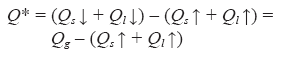
Urbanization produces important changes in the surface and atmospheric local conditions because transformations of the radiative, thermal, hydrologic, and aerodynamic characteristics affect the natural hydrologic and solar energy balances (Oke, 1987). The radiation budget at the surface/atmosphere interface can be expressed in the following way:
 (1)
(1)
where Q* is the net all-wave radiation resulting from the incoming solar radiation (short and long-wave,  ) or global radiation, minus the outgoing short and long-wave radiation (
 ).
).
The net all-wave radiation flux is not only the end result of the radiation budget but also the basic input to the surface energy balance (Oke, 1987), which is expressed as:
 (2)
(2)
where QH and QE are convective fluxes to or from the atmosphere, called sensible and latent, respectively; and QS is referred as the conduction to or from the underlying soil.
The turbulent fluxes of sensible and latent heat of evaporation are responsible for the warming and moistening, respectively, of the atmosphere from the surface up to a height of approximately 100 meters during the day, except in situations of deep convection when the effect extends to greater altitudes. The flux in the soil penetrates only a few centimeters deep (Focken, 2008).
Energy balance measurements in the surface atmospheric boundary layer are scarce in arid environments, as featured by Chow et al. (2014) for Phoenix, Arizona, 330 km east-northeast of Mexicali, and by Offerle et al. (2005), who evaluated the balance at city and building levels for Ouagadougou, Burkina Faso, in west Sahel. In the later site, the net all-wave radiation increased with urbanization because of the higher albedo, lower heat capacity, and thermal conductivity of the bare soil compared to the urbanized surface in residential zones, despite the decrease in albedo in the urban center caused by the materials and geometry of the buildings. As a result, the surface temperatures of bare undisturbed soil could exceed the surface temperatures in the residential area and urban center by 15-20 °C. The turbulent heat exchange measured over a residential area was dominated by sensible heat flux.
For both cities, Ouagadougou (Offerle et al., 2005) and Phoenix (Chow et al., 2014), latent heat fluxes were greater than expected from vegetated areas, which in accordance with water use were primarily irrigated.
Similar to the studies of Mexico City (Tejeda and Jáuregui, 2005, for example), the present work follows the hypothesis that vertical fluxes of sensible and latent heat are turbulent in nature and that the global radiation is distributed uniformly in the study area, which is true for homogenous sky conditions such as a desertic environment (Mexicali and its surroundings). In Mexico City, Velasco et al. (2011) also made observations of the energy balance components in a residential and commercial neighborhood to evaluate the parameterizations and understand the energy balance partitions in tropical urban environments. They found that the largest differences between the modeled and observed fluxes corresponded to incoming long-wave radiation because of errors in cloudiness data, which are inputs to the models.
The objective of this paper is the empirical modeling of the energy balance components (Q*, QH, and QS) as functions of the global radiation for three different types of land use in the city of Mexicali and its surroundings (32.6° N, 115.5° W, 10 masl): urban (Engineering Institute of the Autonomous University of Baja California), farmed suburban (Campestre), and rural (Villa Zapata).
Some estimation models presented hysteresis, i.e., the dependent variables (energy balance components) exhibited one behavior when the independent variable (global radiation) was increasing and a different behavior when it was decreasing, thus completing a sort of ellipse between explained and explanatory variables. The presence of hysteresis was detected in the data from the Campestre zone during the summer, when it was found that in the time from daybreak until midday, the relationship between global radiation and net radiation and the other components of the energy-balance behaved differently than from midday to daybreak (see section 4). For this reason, it was necessary to divide the model into two parts to describe the behavior of the phenomenon, as presented later. In the case of the Engineering Institute, this phenomenon was present only for the global radiation versus net radiation in the summer.
2. Study area
Mexicali is the capital city of the Mexican state of Baja California. It is situated in the northwest of the Mexican Republic and in the northern part of the Baja California peninsula (Fig. 1). Mexicali city has an area of 20 745 ha, according to the Municipal Institute for Research and Urban Planning of Mexicali (IMIP, for its acronym in Spanish, 2010).
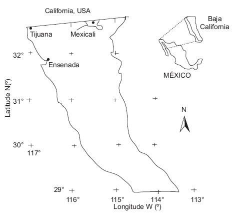
Mexicali has a thermal extreme and dry climate with some precipitation in the winter. The maximum summer temperatures can reach almost 50 °C, whereas in winter they may drop to a minimum of 0 °C (García-Cueto and Santillan, 2012). Mexicali has experienced a significant increase in population as a result of migrants arriving in Baja California with the intention of staying temporarily and the hope of crossing into the United States; but when this migration is unobtainable, many decide to remain permanently in Mexicali. The resulting demand for urban land has been reflected in an ever-greater number of dwellings. In 2010, the population was 940 000, of which 51% were men and 49% were women (http://www.bajacalifornia.gob.mx/portal/nuestro_estado/situacion_dem/demografico.jsp#C).
According to García-Cueto et al. (2004) and García-Cueto (2007), the proliferation of manufacturing and public service activities in Mexicali has implied substantial transformations in land use from agricultural to urban areas in a relatively short time period, with a consequent change in environmental variables. Additionally to the pollution caused by particles, there is now the problem of gases and one of the highest levels of energy consumption (approximately 1000 kWh/user monthly) in Mexico. Undoubtedly, this pattern of consumption is a result of the use of air-conditioning to obtain thermal comfort because of the high temperatures prevailing from the middle of spring until the middle of autumn.
The sites for measuring the atmosphere-surface energy balance components in Eq. (2) are (Table I ; Figs 2-4):
Urban, characterized by buildings of two to three stories, two to four lane streets, residential and commercial uses, and irrigated gardens (Engineering Institute).
Farmed suburban, with dispersed one-story buildings and irrigated corps (Campestre).
Rural, with dispersed one-story buildings, desert (Villa Zapata).


These land uses correspond to the classification of urban climatic zones proposed by Stewart and Oke (2012) for studies on the urban heat island. The Engineering Institute site corresponds to the local climate zone (LCZ) 6 (LCZ 6, open arrangement of 1-3 story buildings, abundance of low plants, scattered trees, wood, brick, stone, tile, and concrete construction materials). For the Villa Zapata location (natural desert), the typology is LCZ F (bare soil or sand). For the Campestre location, the typology is LCZ 9 (sparsely built). (See Table II.)
Table II Values of geometric and surface cover properties for local climate zones. Properties do not have units, except for the height of the roughness elements (m).
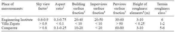
1 Ratio of the amount of sky hemisphere visible from the ground level to that of an unobstructed hemisphere.
2 Mean height-to-width ratio of street canyons (LCZs 1-7), building spacing (LCZs 8-10), and tree spacing (LCZs A-G).
3 Ratio of the building plan area to the total plan area (%).
4 Ratio of the impervious plan area (paved, rock) to the total plan area (%).
5 Ratio of the previous plan area (bare soil, vegetation, water) to the total plan area (%).
6 Geometric average of building heights (LCZs 1-10) and tree/plant heights (LCZs A-F) (m).
7 Davenport et al. (2000) classification of the effective terrain roughness (z0) for city and country landscapes.
One energy balance equipment was installed on the roof of the Engineering Institute at the Autonomous University of Baja California (Fig. 2). Broad streets surrounded it with a traffic island bounded by greenery. The major part of this area is designated for educational, residential, and commercial use. Towards the east lies the sports center of the university zone, an area of greenery covering approximately 16.45 ha. The vegetation consists of grass lawns, trees from Yucatan (Ficus nítida), and eucalyptus trees (Eucalyptus camaldulensis Dehn) maintained through artificial irrigation (García-Cueto et al., 2004; García-Cueto, 2007).
The suburban (Campestre) station is in the environs southwest of the city. Figure 3 shows the establishment of the energy balance station. Although irrigated, the site is surrounded by minimal vegetation.
The rural station was located southwest of the city (Fig. 4). A characteristic of this site is the lack of paved streets, which have been delineated but conserve their natural sandy soil, with houses dispersed among brushy vegetation such as mesquite (Prosopis leavigata) and cachanillas (Pluchea sericea) (García-Cueto et al., 2007).
García-Cueto (2007) showed that atmospheric and surface urban heat islands (UHI) are present in Mexicali. A daily cycle was observed in which the atmospheric UHI develops during the night, but it disappears during the day giving way to an urban cool island. The greatest mean intensity of the heat island in the urban canopy occurs during the spring and fall, with increases in temperatures of 4.4 °C and 4.5 °C, respectively, whereas during the winter and summer the increases in temperature values are of 3.5 °C and 3.2 °C, respectively (García-Cueto et al., 2009). The UHI developed primarily east of the city in a dune area, where land use is mixed, and in the commercial area of the historical center, a short distance from the international border.
3. Data
The data were obtained from energy balance measuring campaigns conducted from February 17 to April 2, 2001 and from June 11 to 25, 2003. As previously mentioned, the selected sites are representative of three land use types in the study zone: urban, rural (desert), and farmed suburban, and the data represent the typical conditions of summer and winter seasons. The global radiation was measured with a LI-COR radiation sensor (LI-200SZ, Lincoln, NE, USA) with a spectral response from 0.4 to 1.1 urn. The net all-wave radiation was measured with a net radiometer Q*7.1 (Radiation & Energy Balance Systems, Inc., Seattle, WA, USA), which is sensitive to wavelengths from 0.25 to 60 urn. Both parameters were measured out every minute and averaged every 30 min. At Villa Zapata and the Engineering Institute, the turbulent fluxes were measured using an eddy covariance system and the energy stored in the soil was estimated as residual in the covariance system.
At Campestre, a Bowen Ratio system was used for turbulent flux estimations, and heat flux plates were used to measure the soil heat flux. The average temperature of the soil layer above the plate was measured using a TCAV (averaging soil thermocouple probe), which is a temperature probe with four parallel thermocouple junctions in one. The TCAV was used in conjunction with the soil heat flux plates to calculate the heat flux at the soil surface. The plates buried at a fixed depth of 8 cm to reduce errors from the vapor transport of heat. A CS615 water content reflectometer was used to calculate the specific heat of the soil (Cs). The values of Cs and the change in soil temperature (ΔTs) measured by the TCAV over the output interval t are required to calculate the energy stored (S) in the soil layer at a depth d above the heat flux plates:
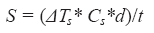 (3)
(3)
Data from the three sites were grouped into periods representing the seasons. The applied criterion was based on the tests for differences of the mean under independences. Because the data sizes of half-hour intervals were greater than 30, we applied the following normalized distribution (Wilks, 2006):
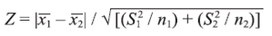 (4)
(4)
where Z is the statistic,  and
and  are the means of the samples from the two periods being compared, S1
2 and S2
2 are their corresponding variances, with n
1 and n
2 being the sizes of each sample. If Z is less than 1.96 (the standardized value of the normal distribution that comprises 95% of the values), then the means are similar with a significance level of α = 0.05. In the opposite case, the means are considered independent.
are the means of the samples from the two periods being compared, S1
2 and S2
2 are their corresponding variances, with n
1 and n
2 being the sizes of each sample. If Z is less than 1.96 (the standardized value of the normal distribution that comprises 95% of the values), then the means are similar with a significance level of α = 0.05. In the opposite case, the means are considered independent.
For the Engineering Institute and Villa Zapata, the data were grouped in three periods: spring (March 7 to April 2, 2001), summer (June 11 to 25, 2003), and winter (February 16 to March 6, 2001); however, for Campestre. data are only available for the summer period (June 11 to 25, 2003). More details on the data are given in Tejeda-Martínez et al. (2010).
4. Statistical estimates
Grimmond and Oke (2002) proposed a local scale urban meteorological parameterization scheme (LUMPS) to calculate heat fluxes for the urban environment. The inputs are net radiation, standard meteorological observations, and basic surface cover information. LUMPS is a better model compared with earlier models such as the hybrid plume dispersion model (Hanna and Chang, 1993). Its improvement results mainly from the objective hysteresis model parameterization (Grimmond and Oke, 2002) of storage heat flux, which takes into account the magnitude ofthis flux, the hysteresis pattern, special coefficients used to partition QH and QE as an effect of the urban green space and/or surface moisture availability, and the positive QH fluxes observed in urban environments after sunset.
The scheme proposed in this paper for Mexicali is simpler (and with lower precision) because it uses as its input only the solar global radiation and its basis are statistical relationships instead of physical considerations as in the LUMPS scheme.
Jegede (1997) demonstrated a large correlation between net and global radiation for Nigeria, and Méndez-Pérez (2001) found similar results for eastern Mexico. Statistical relationships between sensible heat, latent heat, stored heat in soil versus the global radiation for Mexico City were found by Tejeda and Jauregui (2005). This work proposes statistical models for the energy-balance components according to different land uses and seasons of the year. The models are valid only during the daytime when global radiation is not zero. Actually, this results in an error: The energy-balance components also vary during the night. Nevertheless, the generated daytime models present determination coefficients between 0.74 and 0.98 (and only in one case 0.59), i.e., the global radiation explains the variance of daytime energy-balance components between 59 and 98%, as will be later discussed.
4.1 Net radiation
For the cities of Chicago, IL; Los Angeles, CA; and Lodz, Poland, Offerle et al. (2003) demonstrated that net radiation (Q*) could be estimated as a linear function of incident global radiation (Qg ). For Mexicali, the regression estimations of the net radiation have different behaviors during summer -when hysteresis is present- in comparison with spring and winter periods, without hysteresis. The summer measurements were performed from June 11-15, 2003. Clear skies prevailed, with mean daily temperatures of approximately 29 °C, a relative humidity of 28%, and calm air.
As shown in Table III and Figure 5, for the Engineering Institute (urban) and Campestre (suburban) sites (Fig. 5a, b, c and d), due to the presence of hysteresis it was necessary to generate two estimation models for net radiation depending on the global radiation. Therefore, to obtain all the estimation models for energy balance, two periods were considered: from midnight to midday (Fig. 5a, c), and from midday to midnight (Fig. 5b, d), all of which were quadratic regression equations. For Villa Zapata (rural), net radiation as a function of global radiation exhibits a linear behavior, i.e., without hysteresis (Fig. 5e). The magnitudes of the goodness of fit range from 15.3 to 32.6 W m-2 for the mean standard error, and the determination coefficient between the observed and estimated radiation values is ≥ 0.94.
Table III Estimation models the net radiation (Q*) in proportion to global radiation (Q g) for each site during summer.
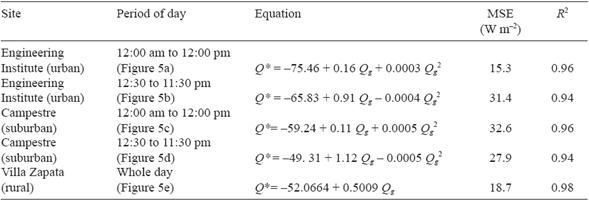
MSE: mean square error; R 2: determination coefficient.
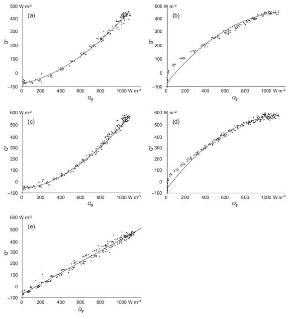
Fig. 5 Regression models of net radiation (Q*) as a function of global radiation (Q g) in summer for: (a) Engineering Institute, midnight to midday; (b) Engineering Institute, midday to midnight; (c) Campestre, midnight to midday; (d) Campestre, midday to midnight , and (e) Villa Zapata, for the whole day.
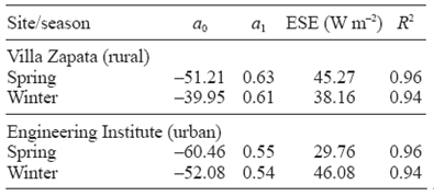
For winter and spring, the measurement campaigns were conducted from February 17 to April 2, 2001. The Engineering Institute does not present hysteresis in winter, in contrast to summer, as seen in Table III (unfortunately, there are no data for Campestre during winter); thus, the regression models for both locations in Table IV (Villa Zapata and Institute) are linear. For all models, the determination coefficients are acceptable, unlike the estimated standard errors, which are large.
Table IV Estimation of net radiation (Q*) for Villa Zapata and the Engineering Institute as linear regression models (Q* = a o + a 1 Qg ), and goodness of fit (estimated standard error, ESE, and determination coefficient between the observed and estimated data [R 2]) for spring and winter seasons. For Campestre, data is only available for summer (see Table II).
4.2 The other components
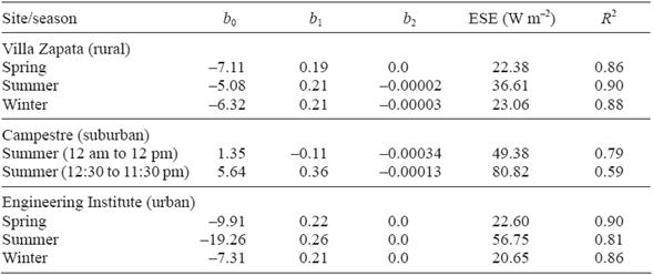
The relationship between sensible heat and global radiation is hysteresis-free for Villa Zapata and the Engineering Institute. For Campestre, hysteresis is present in summer and the quadratic model is required (Table IV). In the case of the estimation models of net radiation (Tables III and IV), the determination coefficients between the observed and estimated data areoutstanding , but the errors are large.
As mentioned in section 3, the stored heat in the soil was measured at Campestre by means of two soil heat flux plates at an 8-cm depth, but at the Engineering Institute and Villa Zapata the stored heat was estimated from the residues in Eq. (2). In addition to the sensible heat, Table V shows that in summer Campestre presents hysteresis, but the quadratic term for its simulation as a function of global radiation was not necessary. Similar to net radiation and sensible heat, the estimated vs. observed data have a high correlation, but their estimation standard errors are also high.
Table V Estimation of sensible heat (QH ) for the three sites, as linear or quadratic regression models (QH = bo + b1Qg + b2 Qg 2 ) and goodness of fit (estimated standard error, ESE, and the determination coefficient between the observed and estimated data [R]2). For Campestre, data is only available for summer.
Although QE was measured with eddy covariance at the Engineering Institute and Villa Zapata, and by the Bowen's ratio system in Campestre, this was not considered statistical modeling from global radiation. Correlation coefficients with global radiation were less significant than other components of the energy balance because their values are very low due to the desert environment, primarily at Villa Zapata.
4.3 Hysteresis
In traditional terms, when the ascending calibration curve does not coincide with the descending curve, this is called hysteresis (Krasnoselskii and Pokrovskii, 1989). The hysteresis effect in diurnal cycles of net all-wave radiation and ground-stored heat has been observed in many places, but its physical explanation remains ambiguous (Sun et al. , 2013). By means of theoretical considerations (primarily the model of Camuffo and Bernardi, 1982) and observations on different surfaces (green, black, white, and ballast roofs, cotton fields and grasslands), Sun et al. (2013) explain hysteresis on the basis of the vertical water flux and the scaled ratio of net shortwave radiation to outgoing longwave radiation. According to Grimmond and Oke (1998), hysteresis can occur in the presence of humidity and/or turbulence. For example, the hysteresis found for central Mexico City can be explained by turbulence (Tejeda and Jauregui, 2005).
In this paper, hysteresis is understood as the discrepancy in the response of the energy balance components (net radiation, sensible or soil-stored heat) to the stimulus from global radiation when it increases or decreases. In this sense, hysteresis was present at the Engineering Institute for net radiation, and at Campestre for net radiation, sensible and soil-stored heat because those energy balance components exhibit one type of behavior when global radiation rises from its minimum to its maximum, and another type when global radiation descends toward its minimum, as represented in Tables III, V, and VI. When hysteresis is present the estimation of net radiation, sensible and soil-stored heat based on global radiation requires quadratic regressions.
Table VI Estimation of the stored heat in the soil (Qs ) for the three sites, as linear regression models (Qs = co + c 1 Qg ) and goodness of fit (estimated standard error [ESE] and determination coefficient between the observed and estimated data [R2]). For Campestre, data is only available for summer.
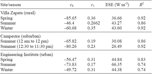
Hysteresis is present in homogeneous (Campestre) and non-homogeneous (Engineering Institute) terrain, so the turbulence is not its primary cause. However, it may result from thermal inertia caused by humidity, because both sites are often irrigated during the summer. Additionally, land surface temperature (LST) plays a role, because it is correlated to all energy budgets, including radiative components in different forms; for example, the upwelling longwave radiation follows the fourth power law as a function of LST, whereas the reflected shortwave radiation follows a linear relationship of the incoming radiation.
The independent terms of the quadratic equations for sensible heat estimation are positive in the statistical models in Table IV, which suggests high values of humidity near the ground at Campestre; i.e., if the global radiation is null, there is positive sensible heat rising from the surface to the atmosphere as a result of sensible heat being released from the condensation of vapor in the soil.
5. Conclusions
The proposed statistical models for different land uses have acceptable goodness of fit: the determination coefficients with global radiation range from 0.72 to 0.98 (with only one case being 0.59), although the estimated standard error values are not small because they fluctuate from 15 to 82 W m-2. No latent heat flux was estimated from global radiation because its values are small in a desert environment. In this estimation scheme, latent heat can be obtained from the differences between the estimated net radiation, the sensible heat flux and the heat stored in the ground. The inherent problem in this procedure, however, is that all of the estimated errors in the fluxes were incorporated into latent heat flux.
The proposed parameterizations are approximations that have the same behavior as the observed data, but with large errors. More data are necessary to improve the statistical models, in order to generate one statistical model for the energy balance components in Mexicali that depends on global radiation only. It is obvious that in this simple model, basic information such as land covers, buildings, impervious surfaces, and standard weather information such as air temperature, humidity, and wind speed is integrated to estimate heat fluxes, but these elements are not disaggregated in the models.
Thus, the previously presented statistical models are applicable to local climatic zones LCZ 6, LCZ F, and LCZ 9 proposed in the classification by Stewart and Oke (2012) and not to the entire city. It is true that the city has grown since the beginning of 2000, but development has been on the periphery and not in the locations where the balance measurements were carried out. Thus, under this premise, the proposed models are applicable in the areas of measurement.
Hysteresis appeared during the summer according to the data from Campestre and the Engineering Institute. If we consider that the thermal inertia of land cover and soil moisture movement are the main causes of hysteresis, we can explain that hysteresis is clear (the thermal inertia of buildings and the soil moisture from gardens around buildings) for the Engineering Institute. In Campestre, where hysteresis is also present, building surfaces are minimal but moisture movement is present, thus the hypothesis of turbulence being the primary origin of hysteresis is not solid in this case. To determine the real cause of hysteresis, a deeper study is needed that registers humidity, wind and balance of energy components to determine which factors influence the presence of the phenomenon in Mexicali.

