


Serviços Personalizados
Journal

Artigo
 Inglês (pdf)
 Artigo em XML
 Referências do artigo
 Enviar este artigo por email
Indicadores
 Citado por SciELO
 Links relacionados
-
 Similares em
SciELO
Similares em
SciELO
Compartilhar

 Permalink
Atmósfera
versão impressa ISSN 0187-6236
Atmósfera vol.21 no.3 Ciudad de México Jul. 2008
Oceanographic characterization of the Veracruz reefs system
J. J. SALAS–PÉREZ and A. GRANADOS–BARBA
Unidad de Investigación de Ecología de Pesquerías, Universidad Veracruzana,
Av. Hidalgo 617, Col. Río Jamapa, C. P. 94290, Boca del Río, Veracruz, México.
Corresponding author: J. J. Salas–Pérez, e–mail: jsalasp39@yahoo.es, jesalas@uv.mx
Received March 3, 2007; accepted April 4, 2008
RESUMEN
Se realiza un análisis e integración de la información bibliográfica generada acerca del sudoeste del Golfo de México con la finalidad de desarrollar un marco oceanográfico que establezca los procesos que a diferentes escalas espacio–temporales, tienen relación con la permanencia y supervivencia del Sistema Arrecifal Veracruzano (SAV), lo cual representa un aspecto fundamental para el entendimiento multidisciplinario del medio marino de esta región. La información se analizó considerando dos principales escalas dinámicas de movimiento: cuenca y zona costera, para integrarse en un modelo conceptual, en el que se propone que la circulación del SAV es resultado de la interacción de diferentes componentes de la circulación y procesos atmosféricos, que tienen efecto en la generación de gradientes de propiedades escalares, las cuales pueden afectar a la comunidad coralina del SAV.
ABSTRACT
An analysis based on the compilation of bibliographic information for the southwestern Gulf of México led to the establishment of an integrated oceanographic framework useful to assess the processes that take place at different spatial and temporal scales. Those scales are related to the survival of the Sistema Arrecifal Veracruzano (SAV). This study should help us understand the multidisciplinary approach necessary to understand the marine environment of the area. The information was analyzed considering two main dynamic scales: the basin and the coastal zone, both included in a conceptual model, which states that the circulation in the SAV is the result of the interaction between the different components of the circulation and atmospheric processes. Both processes influence the generation of gradients of scalar properties, which, in turn, influence the coral reef community of the SAV.
Keywords: Southwestern Gulf of México, Sistema Arrecifal Veracruzano, coastal and basin scales, conceptual model.
1. Introduction
The Gulf of México is a large marine ecosystem in which the ecological characteristics are a combination of tropical and temperate environments. It is an enclosed sea of 1.5 × 10⁶ km2 (Bryant et al., 1991) with large amounts of freshwater discharges from rivers and coastal lagoons as well as urban waters discharges. Together, they are responsible for many coastal systems with great environmental heterogeneity and biological diversity (Toledo–Ocampo, 1996; Arenas–Fuentes and Salas–Pérez, 2005). However, the environmental conditions are not suitable for the development of most coral reefs communities (Jordán–Dahlgren, 2004). Well developed reef systems with variable morphology can be found in the Gulf of México (Heilprin, 1890; Emery, 1963; Lara et al., 1992; Carricart–Ganivet and Horta–Puga, 1993; Jordán–Dahlgren, 2002) although they cover less than 1% of the shallow continental shelf (Jordán–Dahlgren, 2004).
The reef formations of the southwestern Gulf of México, located in front of the Port of Veracruz and Antón Lizardo village (Figs. 1 and 2), are peculiar because they developed close to a terrigenous environment as a result of the discharges of the La Antigua, Jamapa and Papaloapan rivers (Krutak, 1997). Nowadays, those reefs constitute the "Parque Nacional Sistema Arrecifal Veracruzano (PNSAV)", which is a marine protected area of ~54,000 Ha (DOF, 1992). This reef zone was mentioned for the first time in Heilprin (1890), but little has been done since then to formally and comprehensively study the system (Emery, 1963; Krutak et al., 1980; Lara et al., 1992; Jordán–Dalhgren, 1992; 2002), even though it constitutes an important area from any point of view; in fact, for the Sistema Arrecifal Veracruzano (SAV), more information can be obtained from what is known as "grey literature" (such as abstracts from congresses, technical reports, field reports from universities' courses, and bachelor as well as graduate theses) than from formal studies published in scientific articles (ICRI, 1998; Jiménez–Hernández et al., 2007). In the particular case of integrative studies of hydrological processes and coastal dynamics few studies have addressed this issue, which are required to understand the survival of the coral reef system.


It is common knowledge that the reef systems of the world are very productive. They exhibit high biological diversity and represent high economic value in terms of fisheries and tourism (Birkeland, 1997; Glynn, 1997), but they require very particular environmental and oceanographic conditions to subsist. Those conditions are shallow marine oligotrophic, warm waters (> 20 °C), with optimal temperatures between 26–28 °C, and salinities of 33–36 psu, with minimum turbidity and sedimentations (Hubbard, 1997; Carricart–Ganivet, 2004).
The compiling, reinterpretation and integration of the information about the oceanographic processes in this area is basic to understand what are the key elements that govern them and the fluctuation scales at which they function, which are responsible of the permanence and survival of the SAV.
2. Methods and materials
In order to establish an oceanographic characterization of the SAV, sixty three bibliographic references were used: twenty four of those were articles published in indexed journals, eighteen were book chapters, four books, two monographs, six technical reports, two congress proceedings, two congress abstracts, two master theses, one official document, one divulgation article and one CD–ROM. The bibliography used in this study contains information derived from in situ observations in the SAV or in the Gulf of México. In addition, information generated with numerical models applied to the coastal zone and to the basin scale was used in order to establish a teleconnection between both scales. To define this first oceanographic framework for the SAV, publications regarding other regions related to the research on the interactions between the oceanographic conditions and the status of the reef systems were also used.
The method used in this characterization included basin and coastal zone scales according to the available information. Then, based on the analysis of the existing information, a conceptual model is presented, including the different components of the marine circulation as well as other aspects of the physical oceanographic environment which affects the environmental variability of the region where the SAV is located. Those aspects are considered determinant for the permanence and survival of the system.
3. Results
3.1 Conformation of the oceanographic framework
3.1.1 The Sistema Arrecifal Veracruzano
Two of the most complex and important reef groups of the Gulf of México are located in the central region of the Veracruz costal zones, and they are set in a general pattern that seems to follow the coastline. A group of eleven reefs are located in front of the Veracruz–Boca del Río cities and another group of twelve reefs with larger structures are located in front of the town of Antón Lizardo; both groups are divided by the Jamapa River and limited, respectively, to the north by La Antigua and to the south by the Papaloapan rivers (Fig. 2). According to Lara et al. (1992) these reefs are geomorphologically well constituted; some of them are located up to 20 km from the coastline while others are so close that they have been reached by urban growth. The reefs vary in length from ~0.3 to 3.2 km, covering an area that goes from ~1 to 19 km2 at depths between 20 and 45 m, in addition to the reef lagoons which are shallow (reaching 2 m) (Lara et al., 1992; Vargas–Hernández et al., 1993).
3.1.2 Bathymetry and physiography of the area
The coastline of Veracruz and its depth profiles are characteristically bow shaped with a narrow continental shelf (~33 km) and average depths of less than 70 m. The seabed is topographically complex due to the presence of shallow banks, reefs and islands forming a series of channels with variable horizontal dimensions and depths (Fig. 1). This physiographic complexity can play an important role in the modifications of the flows generated by the different circulation components of the Gulf of México and are evident at the SAV scale; however, those components have not been studied in detail.
3.2 Oceanographic conditions of the study area
The mechanisms which affect the fluctuations of the hydrological parameters, ocean–atmosphere interactions and circulation within the Gulf of México have been studied more from a basin scale perspective than from a coastal zone point of view.
3.3 Atmospheric processes
The climate in the southwestern region of the Gulf of México is of the type Am (warm and humid) with abundant rains in the summer and part of the autumn, and a short dry season (from April to May), and annual average precipitation of 1100–2000 mm. The average annual temperature is 26 °C, with a minimum of ~18 °C in January–February (García, 1987).
The Gulf of México is a region in which the studies of the variability of the meteorological parameters are relevant to understand the dynamics of its marine waters. The wind in the Gulf of México blows toward the east–southeast in autumn–spring and in an east–northwest direction during spring–winter (Gutiérrez de Velasco and Winant, 1996; Monreal–Gómez and Salas de León, 1997). The seasonal fluctuations of the atmospheric systems of pressure introduce some variability from autumn to winter (October through April), dominated by frontal incursions locally known as "nortes" (northern winds). From spring to summer, the atmospheric variability is dominated by tropical storms which can evolve to hurricanes (Gutiérrez de Velasco and Winant, 1996).
In the Gulf of México the hurricane season goes from June to November with an average of nine per year (analyzing the period from 1958 to 1996). The more serious effects are felt specially in the north–northwest regions of the Gulf and the Yucatán Peninsula (Caballero–Rosas, 1990; Monreal–Gómez and Salas de León, 1997); nevertheless, according to data from http://www.nhc.noaa.gov/pastall.shtml, http://weather.unisys.com/hurricane/index.html and Luna–Bauza (1994), summarized in Gómez–Ramírez (2006), from 1931 to 2005, the trajectories show the arrival of twenty four hurricanes to the state of Veracruz, but only five impacted the central region of Veracruz, where the SAV is located.
3.4 Water masses
3.4.1 Basin scale
Five water masses of Atlantic and Caribbean origin can be identified in the Gulf of Mexico (Nowlin and McLellan, 1967; Vidal et al., 1992). In the surface layer (0–300 m depth) of the Gulf of México, the Subtropical Subsurface Caribbean Water (StSsCW) can be identified with a characteristic temperature value of 22.5 °C and a salinity of 36 ups. The Subtropical Subsurface Gulf of México Water (StSsGMW) has a salinity of 36.4 ups and temperatures of 22 °C. The surface layer (~250 m) of the western continental shelf of the Gulf of México (where the oceanic region of Veracruz is located) is composed by the Subtropical Subsurface Water (StSsW) (36.5 ups and 20 °C), and by the Common Gulf of México Water (CGWM) with characteristic values of salinity of 36.5 ups and 22.5 °C. This last one is the result of a process of mixture induced by eddies collisions produced by the Loop Current with the western continental slope (Vidal et al., 1992).
In annual basis, the density values in the Gulf of México continental shelf are determined by the annual fluctuation of the salinity. The water column is well stratified throughout the year, except for the winter when the atmospheric fronts ("nortes") can produce important mixing processes (Dagg, 1988; Monreal–Gómez and Salas de León, 1997; Monreal–Gómez et al., 2004).
3.4.2 Coastal zone scale
In this area, two water masses can be clearly distinguished (Hernández–Téllez and Salgado–Rivero, 1996): one coastal water mass (S = 34–36.5 psu and T = 21–29 °C) resulting from the mixing of the CGMW and the coastal water, and a water mass diluted (S = 29–34 psu and T = 27–33.5 °C), as a result of the mixing of the river discharges and the coastal water. The time variability of the conservative properties (temperature and salinity) of the water masses in the Veracruz coastal zone is influenced (from autumn to late spring) by the "nortes" events which can cause the water temperature to drop various degrees centigrades in a matter of hours (Arenas–Fuentes and Salas–Pérez, 2005).
Specifically, based upon time series of temperatures measured in the leeward zone of Isla de Sacrificios and the windward zone of Isla Verde, Vázquez de la Cerda (1983) detected, in a five day period, a decrease in water temperature of 1.5 °C after two consecutive "nortes" events. During the same period, the salinity also diminished between 0.5 and 2.0 psu. These results agree well with the TS diagrams computed before and after the passage of a "norte" in the region, which showed a decrease in temperature and salinity values of 2 °C and 2 psu in the SAV (Salas–Pérez et al., 2007a). During the rainy season (July to September), the salinity could be reduced by the increase of continental discharges to the ocean (Hernández–Téllez and Salgado–Rivero, 1996).
3.5 The circulation within the Campeche Bay
The macro–scale circulation within the Campeche Bay is represented by a cyclonic circulation which is originated in the western part of the Yucatán Peninsula, when the water flow entering the Yucatán Strait interacts with the topographic contour of the Peninsula (Monreal–Gómez and Salas de León, 1990); however Vázquez de la Cerda et al. (2005) relate the generation of the cyclonic circulation to the wind stress curl. Monreal–Gómez et al. (2004) using hydrographical and current parameters, measured in the Campeche Bay during August of 1996, detected the presence of a bipolar system constituted by: 1) a cyclonic eddy with a maximum axis of 96–92.5° W and minimum axis of ~18.5–20.5° N which embraces almost 75% of the bay, with cold waters in the center and warm waters towards its outer boundary, close to the coasts of Veracruz, Tabasco, and Campeche; and 2) an anticyclonic eddy of geographical dimensions ~97–94.5° W (major axis), ~20.5–22° N (minor axis) (to the north, in front of the Veracruz coasts), with warm waters in the center and colder waters in its outer boundary.
The spatial and time evolution of eddies was analyzed with maps of sea level anomalies (SLA) generated with altimetry Topex–Poseidon radar. It was found that the anticyclonic eddy, in front of the littorals of Veracruz and Tamaulipas, vary its size owing to the fluctuation of the cyclonic eddy located in the center of the Campeche Bay (Leben, 2005).
3.6 Wind induced circulations
3.6.1 At the basin scale (in–situ observations)
Knowing the seasonal wind distribution over the southwestern shelf of the Gulf of México, it is possible to forecast the generation of a system of currents produced by this mechanism, which should be confined to the continental shelf (100 m isobath located at ~ 40 km from the coast). The flux is directed toward the south in autumn–winter and to the north in spring–summer (Zavala–Hidalgo et al., 2003). Sturges (1993) detected, using ship drifts, a Western Boundary current which is caused by the wind stress curl (going up to maximum latitude of 18–20° N) which is directed to the north in July, when the wind strength is at its maximum. This current is intensified by means of the Ekman pumping (the transport of bottom water to superficial layers), with a mixing layer located at the top 25 m of depth, creating a jet stream; such pumping effect should be important in the generation of a coastal upwelling in the Veracruz shelf.
3.6.2 At the basin scale (numerical model)
Following the seasonal wind distribution (Gutiérrez de Velasco and Winant, 1996), the Navy Coastal Ocean Model (NCOM) was used to study the induced circulation produced by the wind force at a basin scale (Zavala–Hidalgo et al., 2003). The numerical results (obtained for a cell grid of 6 km) of a simulation period of seven years reproduce a flow over the continental shelf of Tamaulipas–Veracruz directed southwards, from September to March (autumn–winter) and to the north from April to August (spring–summer) (Fig. 3).

3.6.3 At the coastal zone scale (numerical model)
In the coastal zone, the wind induced circulation, for a seasonal scale, over the Vergara Bay, the SAV, and the mouth of the Jamapa River (96–96°12' W and 19°02'–19°16' N; Fig. 1), was studied with a numerical model. The model was hydrodynamic–barotropic and bidimensional explicit, using finite differences over a cell mesh of 500 m length (Caballero–Rosas, 1990). The results from this numerical model are: with a wind blowing from the north at a speed of 35 m s–1 (condition of "norte"), the currents flow in a north–south direction, adapting their path to the coastal margin. The current speed among the reefs is of 80 cm s–1. From Punta Mocambo to the northern part of the mouth of the Jamapa River, the speed intensifies to 110 cm s–1, and to the south (nearby Antón Lizardo) it drops to 80 cm s–1 (Fig. 4a).
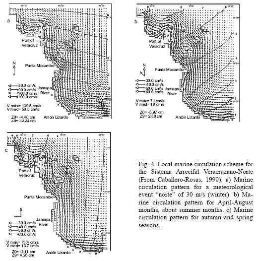
If the wind is blowing towards the southeast (coinciding with the months of April–August, approximately during the summer) with a speed of 15 m s–1, the speed of the currents is not higher than 50 cm s–1 (Fig. 4b). In average, the currents are of 10 cm s–1, and their direction are mainly toward the north through the reef channels, close to the open sea and inside the Vergara Bay. In Isla Verde, those currents have a south–west component, and in their windward zone they are divided in two branches: one maintains their direction to the north and the other turns to the south. The northern branch recirculates to the south because of the presence of a cyclonic eddy of 3 km of diameter, going between the Pájaros and Gallega reefs. Between Isla de Sacrificios and the coast, the current flows southwards in the form of a jet stream and it reaches as far as Antón Lizardo (southern boundary). Therefore, the maximum speeds are found again between Punta Mocambo and the northern part of the mouth of the Jamapa River. Associated to this jet stream, a dipole is observed, where the cyclonic eddy of an almost circular form (located in front of Punta Mocambo) is larger in diameter (15 km of radius) than the anticyclonic elliptic eddy (10 km of radius) detected in the coast, between the zone of the Jamapa River and Antón Lizardo.
The direction of the current with the wind blowing toward the east with a magnitude of 15 m s–1 (predominant in autumn and spring), goes to the north and follows the coastal margin (Fig. 4c). The maximum speed (60 cm s–1) is found close to the southern boundary (Antón Lizardo) and the SAV. Toward the south of Punta Mocambo, there is a cyclonic eddy attached to the coast with its major axis oriented along the coastline. A similar current direction is obtained for a wind with a magnitude of 15 m s–1 blowing from the southeast and south (autumn and spring). The difference is that with the last speed the cyclonic eddy is not generated.
For a wind blowing from the northeast (15 m s–1), there is a current (with a speed of < 20 cm s–1) which penetrates from open sea to the north between Anegada de Adentro and Isla Verde, following its route towards north between the reefs of Blanquilla and Galleguilla, up to Vergara Bay. In front of the Veracruz Port, from La Gallega reef, there is a flow (20 cm s–1) going south, passing between Isla de Sacrificios and the coast, until it reaches the mouth of the Jamapa River where its speed increases to 30 cm s–1. In front of the Jamapa River mouth there is a cyclonic eddy.
Considering a wind blowing from the southwest (15 m s–1), a spatial distribution of the currents similar to those obtained with a wind blowing from the northeast is observed, but flowing in the opposite direction. With a wind blowing from the west and northwest (15 m s–1) the currents flow from north to south in the whole study area. In the first case, an anticyclonic eddy formed south of Punta Mocambo and a cyclonic eddy in front of Anegada de Adentro reef.
3.6.4 At the coastal zone scale (in–situ observations)
In February 1980 ("nortes" season), Vázquez de la Cerda (1983) installed two current–meters: in the leeward side of Isla de Sacrificios at 10 m depth and another in the windward side of Isla Verde reef at 5 m depth. The time series were deployed for sixteen days (February 6 to 22). The mean vector of the velocity calculated between Isla de Sacrificios and the coast was oriented to the north, that is, in opposite direction to the wind blowing (from north to south), while the mean vector of the speed in the other locality was oriented to the south, correlated to the direction of the winds (from north to south).
On the other hand, in the summer of 2004, the current paths were measured with Lagrangian buoys for a short period (less than 25 h) on the SAV. Those buoys showed that there was a predominant flow in a south–north direction (with maximum speeds ranging between 14 cm s–1 to 63 cm s–1), which correspond to the direction of the flow represented in the circulation schemes generated by numerical models of coastal and basin scales (Salas–Pérez et al., 2007c).
3.7 Rivers plumes or coastal fronts
The western region of the Gulf of México is characterized by the presence of rivers that discharge in the Continental Shelf of Veracruz (Fig. 2). Close to the SAV are located La Antigua River, to the north, with an annual discharge of 2.88 × 10⁶ m3 year –1, the Jamapa River, in the centre of the whole system with an annual discharge of 1.89 × 10⁶ m3 year –1 and the Papaloapan River, south of the SAV, with an annual discharge of 36.19 × 10⁶ m3 year –1 (Tamayo, 1999). The river systems that drain in the Gulf of México contribute with terrigenous sediments from the coastal plains and the mountains; the influence of these kind of systems on the coasts in tropical zones is well documented by Alongi (1990).
3.8 Tides
Analyzing the time fluctuations of the sea level during the year 2003 (referred to as the main lower low tide) with the tide gauges located in the Tuxpan (21°00' N, 97°20' W), Alvarado (18°47' N and 95°46' W) and Coatzacoalcos (18°08' N and 94°25' W) stations (http://www.cicese.mx/predob), it was noted that the minimal annual average amplitude of the tide takes place in the Coatzacoalcos (21.45 ± 20.62 cm) and Tuxpan (18.69 ± 19.77 cm) stations. On the contrary, the mean maximum amplitude takes place in Alvarado (24.32 ± 19.21 cm).
An harmonic analysis was applied to the time series measured with those tide gauges. The dominant tide amplitudes obtained along the Veracruz coast were as follows. The diurnals K1 (23.92 h) and O1 (25.83 h) resulted in amplitudes larger than 14 cm, except the harmonic P1 (24.03 h) which amplitude did not exceed 4 cm. Regarding the semidiurnal harmonics, the harmonic M2 (12.4 h), fluctuates in amplitude over the interval from 6.37 to 7.93 cm, and the harmonic S2 (12 h), shows lower amplitudes, varying between 1.79 and 2.43 cm. According to the form number represented as F = O1 + K1/S2 + M2, calculated as a function of the main diurnal and semidiurnal components, the tide along the coast of Veracruz is considered predominantly diurnal (F > 3.0) as Salas–Pérez et al. (2007b) confirmed. The fortnightly tide harmonic and those resulting from the interaction of the wave tide with the sea bottom showed amplitudes < 2 cm, therefore, their contribution to the generation of currents in the Veracruz coasts seems to be insignificant. However, Salas–Pérez et al. (2007b), inferred from a network of time series of sea levels from pressure sensors distributed in the SAV, that the fortnightly harmonic could be as energetic as the semidiurnal harmonics.
On the other hand, buoy trajectories of short temporal length (< 5 h) were measured in the mouth of the Jamapa River, during the months of July, 1986 and April, 1987 (one trajectory per month). Those trajectories showed the flood and ebb flow of the tide current in that zone (Herrera–Cervantes, 1987). Also, with the time series of speed covering periods longer than 24 h, calculated from a Lagrangian buoy traveling between the Chopas and Enmedio reefs, the tide ellipses were calculated for the harmonics K1 and M2, finding that the semi–major axes were 9.42 ± 2.11 cm s–1 for the K1 and 6.83 ± 1.48 cm s–1 for the M2, with a south–north direction (Salas–Pérez et al., 2007c).
3.9 Waves
In general, the wave pattern in this region is of low energy, except for the "nortes" and hurricane seasons. Due to the seasonal wind variations, the wave pattern computed from a hindcast in this zone is also seasonal (http://www.oceanweather.com), coming predominantly from the north, northeast and northwest, and it is more energetic than the summer wave pattern coming from the east, southeast and south. During the "nortes" season, the largest wave is 5 m high at the 5 m isobath, while in waters more than 20 m deep, it reaches 8 m. During the hurricane season, the maximum wave height registered is of 3 m in the 5 m isobath and of 6 m in waters deeper than 20 m. The wave pattern generated by the wind effect may affect the coral community of the region.
The littoral current generated by waves patterns during December was inferred studying the variations of the sediment grain sizes distribution which show that it is distributed in the following way: from Punta Gorda to Punta Mocambo (Ingeniero reef) the flow goes to the south, while from Punta Mocambo to the mouth of the Jamapa River, the coastal transport was towards the north. Finally, from the southern region of the town Antón Lizardo to the south of the Jamapa River, the coastal current runs towards the south (Hernández–Rosario, 1990).
3.10 Conceptual model
Based on the previous oceanographic information described in the preceding section, a conceptual model is proposed (Fig. 5). In this model, different components of the marine circulation and atmospheric processes are included as processes which may influence the hydrographical conditions (temperature and salinity), nutrient concentrations, sediment conditions (grain size distributions and so on) and, therefore, the coral community of the SAV. It is unknown which component of the marine circulation is the predominant over the others; but in the next section, some hypotheses are proposed.

4. Discussion
The SAV is a region of high ecological importance in which the scientific state of the art is still incipient. The lack of knowledge of its physical oceanographic characteristics is evident and despite the large amount of technical information, most of that information has not yet been formally published and has not gone through the process of a scientific revision. In fact, according to the ICRI data (1998) and Jiménez–Hernández et al. (2007), more information exists in the form of "grey literature" than as peer reviewed scientific articles.
According to Lara et al. (1992), the SAV reefs are peculiar in their zonal characteristics: they include a coral community relatively diverse but with low coral coverage, few species of scleractineans and low topographic complexity in the bordering reefs close to the coast. The opposite is true for the reefs that are far away from the coast. A remarkable characteristic of this reef system is its good development in spite of the fact that it has been subjected to stress either natural or induced. This impact has been poorly documented in a formal way as it is done in this study. Tunnell (1992) describes the stress as a product of the contrasting seasons prevailing in the region, which include a rainy season with large river and rain discharges in the summer, and a winter season with strong winds or "nortes", whose speed can be higher than 30 m s–1; nevertheless, the effects on the SAV corals or their biota, have not yet been measured or evaluated, which in turn prevents the accurate assessment of the physical dynamics and biogeochemical factors that regulate its permanence and survival in this area of the Gulf of México.
In addition to the natural stress, the anthropogenic stress is evident, ever since the Spanish conquest in the XVth century (since then, Veracruz has always been an important commerce route). The Spanish extracted coral for the construction of forts (Carricart–Ganivet, 1998; Lang et al., 1998). More recently, the main impacts are caused by an intense port activity, inadequate fishing practices, and, among other activities, by the urban zone of Veracruz–Boca del Río–Medellín. With approximately 700,000 inhabitants (http://www.inegi.gob.mx/est/contenidos/espanol/sistemas/conteo2005), this growing urban and tourist development of medium scale dimensions dumps waste water without previous treatment directly to the sea, action that could be a severe cause of environmental stress. Nevertheless, their effects on the reef system have not yet been evaluated.
Regarding the ocean–atmospheric processes, at the basin scale, it is assumed that the global variations of the oceanographic conditions have a local effect individually or as a whole on the SAV oceanographic conditions. The atmospheric fronts ("nortes") produce important mixing processes that have not yet been quantified in the study area but that, according to Gallucci and Netto (2004), induce the connections between the benthic and the pelagic compartments in the shallow coastal systems. This occurs by the modifications in the water column conditions (increase in the chlorophyll–a and the availability of nutrients) and the sediments (suspension and erosion phenomena, change of texture) which negatively influence the benthic community structure in general.
During the "nortes" season, there is an important variation in the heat fluxes that are exchanged between the atmosphere and the ocean, because the low air temperatures caused by the cold air masses coming from the north of the United States and Canada penetrate into the Gulf of México; this and the decreasing precipitation, could affect some stages of the coral reefs life cycle due to the variation in salinity and temperature. Arenas–Fuentes and Salas–Pérez (2005) suggested that the "nortes" could produce a reduction in water temperature in the SAV in a matter of hours, which in turn may affect the optimal temperature values (26–28 °C) required for the survival of the coral communities. On the other hand, the "nortes", besides inducing the mixing processes, may induce also resuspension of the sediment that has accumulated over the reefs during the summer; this would happen just in the season when the rivers have their highest discharges over the study area. As a result, favorable conditions for the photosynthesis processes in the reefs are created.
During the rainy season, the higher temperatures and the weaker eastern winds may have a negative effect over the coral community. It has been found that, in the northern region of Veracruz (on the continental shelf) the CGWM might be diluted with freshwater discharged by the different rivers found along the coast; this is why low salinities are recorded (Vidal et al., 1994), a requisite for the coral survival.
It is important to highlight that the rain associated with atmospheric storms could substantially increase the continental discharges to the coastal zones, changing drastically the hydrographic characteristics and the local sediment distribution, affecting the benthic fauna (Washburn et al., 2003).
In general, the wave pattern in this region is of low energy, except when "nortes" or hurricanes strike and then strong storms surges occur, characteristically increasing the sea level close to the coast. The storm surge effect over the reefs can translate in a process of exfoliation of entire parts of the system (Woodley et al., 1981).
It is relevant to understand the effect of the discharges over the generation of plumes or thermal fronts in the SAV area, since in addition to the immediate effect on the local hydrographic parameters, they bring down salinities and temperatures in the marine waters (Czitrom–Baus et al., 1986; Shirasago–Germán, 1991) and also affect the sediment and the structure of benthic communities (Cruz–Abrego et al., 1991). The interaction of the rivers with the ocean generates a local circulation system, which might be an efficient mechanism for the exchange of properties between the coastal zone and the open sea and vice versa, as it has been registered for the Campeche Bay icthyoplankton (Salas de León et al., 1998). Also, this factor could influence the sediment deposit on the coral communities located in the Veracruz Continental Shelf.
The sediment discharged in front of the Jamapa River is defined as sands and fine clay of terrigenous origin (Hernández–Rosario and Tinoco–Blanco, 1988). Also, on the reef systems of Veracruz and Antón Lizardo, layers of sediment of terrigenous origin have been observed in situ (Krutak, 1997). Those sediments have been directly related to the waters discharged by the above referred river systems, though the transportation of those sediments from the plume of the rivers to the coral communities has not been demonstrated. The local zone circulation promoted by the wave patterns, the tides and the winds as well as by the meteorological phenomena such as hurricanes, tropical storms, "nortes" and marine breezes might alter the shape and dimensions of the plumes in time scales of hours or days, and therefore their intrusion to the reefs.
According to Krutak (1997) the origin of the fine sediments, non carbonated sands and fragments of volcanic stone found on top of the reefs in front of the Port of Veracruz come from the Jalapa Province (Teziutlán) through the La Antigua River, whereas the origin of the terrigenous sediments (and the calcified algal cells) found on top of the Antón Lizardo reefs come from the Jamapa River basin (near the Pico de Orizaba, Citlaltépetl) volcano and the Papaloapan River (Juárez Mountain Chain).
The influence of the circulation of the Campeche Bay in the SAV could be originated from the outers boundary of eddies located in that region, a jet stream (of variable intensity and position with respect to the fluctuation of both eddies) which carries waters from the center of the Gulf of México towards the shelf and coastal zone of Veracruz. This interaction between eddies constitutes a source of exchange between the waters of the central part of the Gulf and waters of the coast, such as has been observed in the northern part of the Gulf of México (Toner et al., 2003).
Salas de León et al. (1998), with a numerical model applied to the Campeche Bay, studied the distribution of the zooplankton communities owing to the effect of a saline front formed by the Grijalva–Usumacinta discharges and by the cyclonic eddy mentioned above. Those authors found that, during the rainy season (when the cyclonic eddy generates, and the current brings the oceanic communities towards the centre of the bay) zooplankton enrichment can be observed in the delta of the Grijalva–Usumacinta River. On the other hand, in winter (when the cyclonic circulation is well developed) the ocean communities are confined to the west of the bay, in front of Veracruz. These results allow assuming that both the coast and the continental shelf of Veracruz are being affected by a similar process, or maybe even a more complex one, if the topographic effect of the islands and other circulation components are considered. It is likely that the fluxes originated by the fronts and the plumes created by the discharges of the rivers plus eddies flow (anticyclonic and cyclonic), may temporarily impact the coral community of the region because of the changes in temperature and salinity caused by this type of interactions between the circulation components.
According to Sturges (1993) and Zavala–Hidalgo et al. (2003), the macro scale circulation schemes induced by the winds effect show a teleconnection with the local circulation schemes generated by Caballero–Rosas (1990), with a dominant flux going to the north for the winter and in opposite direction for the summer. The winds used to force the model to a coastal zone scale are not representative of the wind field dynamics for the Gulf of México studied by Gutiérrez de Velasco and Winant (1996); this means that only characteristic wind speeds and directions were used; on the other hand, the numerical results of the marine circulation in this zone are conditioned by the characteristics of this stationary forcing.
When the numerical model of Caballero–Rosas (1990) was forced with a characteristic wind of a "norte" event, it described a current moving towards the south. However, the in situ observations of Vázquez de la Cerda (1983) between Isla de Sacrificios and the coast during a "norte" event, show an opposite current (towards north), indicating that the presence of reefs (Chopas and Blanca) form a natural barrier that precludes the free flow of water to the south. This causes a water accumulation zone that generates a pressure gradient which should be balanced by a speed component going north. In this respect, the gradient could probably be induced by the Ingeniero reef and not by those mentioned above, although this hypothesis needs to be corroborated. It is important to emphasize that the results of the numerical model at the local scale were not validated with the proper set of synoptic in situ observations of a seasonal time scale; however, the circulation fields generated are an initial reference on how the wind induced currents could spatially be distributed over the SAV.
In general, the wind induced circulation could influence the hydrographic conditions of the SAV and its nutrient concentrations, affecting the coral communities because during autumn and through spring the low salinity waters discharged by the rivers Mississippi–Atchafalaya can reach the Tamaulipas–Veracruz shelf and enter to the southern region of the Campeche Bay as Zavala–Hidalgo et al. (2003) indicate.
Considering the seasonality and general current patterns, the rivers influence the SAV differently, according to their geographical location. The Jamapa River could have an influence (freshwater and sediments) during the whole year with a major effect on the coastal reefs and smooth effect towards the inward shelf; however, during winter, when the current goes south, it will influence the group of reefs closer to the coasts of Antón Lizardo. During summer, when the current goes north, the influence of the river will be on the group of coastal reefs in front of the Port of Veracruz (Krutak et al., 1980). The Papaloapan River, in turn, has an influence over the SAV only during summer when the current goes north (Krutak et al., 1980). Finally, La Antigua River is influencing the SAV in winter when the current goes south and has a local effect on the coastal reefs closer to the Port of Veracruz (Punta Gorda, Gallega and Galleguilla reefs).
The tide along the State of Veracruz is mainly diurnal, even though the results of Salas de León and Monreal–Gómez (1997) differ from this study, because they found that the tide in this area is a diurnal mixed type. Nevertheless, at the local scale, the role that the diurnal, but also the semidiurnal (M2) and fortnightly (Msf) tides play in the generation of tidal currents within the SAV is unknown (Salas–Pérez et al., 2007b). The tidal currents (102 m s-1) inside the Gulf of México are weaker than those generated by the Loop current and the eddies (1 m s-1) (Salas de León and Monreal–Gómez, 1997), in this region. These currents have not yet been measured, there are not in situ observations and therefore their magnitude, direction and spatial distribution is not known.
At the basin scale, the tide M2 behavior and its residual current within the Gulf of México have been studied by Reid and Whitaker (1981), Salas de León and Monreal–Gómez (1997) and Kantha (2005) with numerical models which consider the oceanic and the astronomic tide, in addition to the bottom friction; however, those numerical models represent tide currents simulations at the basin scale, and therefore, the bathymetric effect of the reefs and the channels formed by the islands of the SAV are not considered. In the SAV, Salas–Pérez et al. (2007b) found that phase differences in each energetic harmonic (diurnal, semidiurnal and fortnightly) are induced by topographic effects. Near the Jamapa River mouth, it could be induced by the river discharges.
The results of the numerical simulation characterize the wave tide M2 with three amphidromic points distributed in the northern region of the Yucatán Peninsula, in the center of the Gulf and to the north close to the coast of Texas–Louisiana. From the amphidromic point, located in the center of the Gulf of México, the tide amplitudes increase from 1 to 6 cm (from the center of the Gulf to the coast), displaying a cyclonic rotation around the Gulf, and amplitudes that correspond approximately to those obtained from the harmonic analysis for the harmonic M2 (from the time series of the sea level of the stations located along Veracruz). The tide ellipses (tide currents) obtained with a numerical model in the zone in front of Veracruz are anisotropic (north to south) and their magnitudes are smaller than 20 cm s–1. The tidal ellipse magnitudes calculated with the numerical model duplicate the amplitude of the ellipses calculated with a Lagrangian trajectory larger than 24 h length (Salas–Pérez et al., 2007c). Because of this, it is necessary to further investigate the tides dynamics and their currents in this zone.
The residual circulation that the tide M2 may generate when its time variations are averaged over several cycles shows, in general, movements shorter than 2 m2 s–1 over the Continental Shelf of Veracruz. This contradicts the results obtained with the calculated amplitudes for the fifteen days harmonics (< 2 cm) which, in principle, would indicate that the residual circulation along the Veracruz coast could be very weak.
It is likely that the role that tides flows play on the coral community is in the concentrations distribution of the biogeochemical parameters of the area, associated to the mixing processes, and to the coral larvae transport. Moreover, considering the complexity of the local topography, it is uncertain whether the interaction of a tide like this could induce a residual flux related to a "street of Karman vortices" (Kundu, 1990).
Regarding the wave pattern, some studies argue about the relationships between the wave energy and the zoning of the coral communities, or about the preferred orientation of the coral communities regarding the dominant wave direction. Heilprin (1890) and Emery (1963) attribute the elongated shape and the NW–SE orientation of the SAV reef to the wave pattern; however, those authors do not validate their assessments with direct measures. On the other hand, Chappel (1980) has detected that the environments with high energy waves are favorable to the corals and coralline algae incrustation, and also to the development of coral topographic ranges.
5. Final considerations
For this study, the information of the oceanic and atmospheric processes that influence the hydrology and dynamics of the SAV circulation were integrated. Its topographic complexity (shallow bottoms, reefs, channels and islands) plays an important role in the alteration of the fluxes generated by the different components of the circulation in this region of the Gulf of México.
Based on the conceptual model presented in this study, we suggest that the circulation in the SAV zone is the result of the interaction of the different oceanic–atmospheric circulation components. The behavior of those components are still unknown at the SAV scale.
It is difficult to understand the ecological process that makes the permanence and survival of the coral reefs possible in the SAV without multidisciplinary studies that can establish the cause–effect relationships of the environmental variability in the area. Those effects promoted by the oceanographic and physical processes, to a large extent are themselves influenced by oceanographic processes that take place at a basin scale. In order to understand those multidisciplinary processes, it is necessary to obtain time series of current speeds, temperatures, salinities, turbidity and nutrients. This is needed to define the time–space scales and their dominant fluctuations and, therefore, to understand their effects on the coral community of the SAV.
Acknowledgements
The authors would like to acknowledge the Unidad de Investigación de Ecología de Pesquerías of the Universidad Veracruzana for its support. This research was financed within the framework of the projects "Determinación de los indicadores críticos para la Operación del Plan de Manejo del Parque Nacional Sistema Arrecifal Veracruzano" (FOSEMARNAT–2004–01–181) funded by SEMARNAT–CONACyT, the "Trayectorias de masas de Agua en los sistemas arrecifales de Veracruz" (UVER–PTC–98) and "Fortalecimiento Disciplinario para el Desarrollo y Consolidación del cuerpo Académico Manejo y Conservación de Recursos Acuáticos" supported by the Programa de Mejoramiento del Profesorado (PROMEP–UV). Also we deeply appreciate the reviewers' comments since they improved this manuscript.
References
Alongi D. M., 1990. The ecology of tropical soft–bottom benthic ecosystems. Oceanogr. Mar. Biol. Ann. Rev. 28, 381–496. [ Links ]
Arenas–Fuentes V. and J. J. Salas–Pérez, 2005. El Golfo de México, una aproximación a los determinantes de su biodiversidad. In: Camarones, langostas y cangrejos de la costa este de México. (J. L. Hernández Aguilera, J. A. Ruiz Nuño, R. E. Toral Almazán and V. Arenas–Fuentes, Eds.) Econatura y Conabio, México, 7–21. [ Links ]
Birkeland C., 1997. Introduction. In: Life and death of coral reefs (C. Birkeland, Ed.) Chapman and Hall, USA, 1–12. [ Links ]
Bryant W. R., J. Lugo, C. Córdova and A. Salvador, 1991. Physiography and bathymetry. In: The geology of North America. The Gulf of México basin (A. Salvador, Ed.) Boulder, Colorado, The Geological Society of America. USA, Vol. J, Chpt. 2, 1–18. [ Links ]
Caballero–Rosas A., 1990. Modelación hidrodinámica numérica de la circulación por viento en la zona costera del Puerto de Veracruz y sus proximidades. Tesis de Maestría en Ingeniería Oceánica, Instituto de Ingeniería, Universidad Veracruzana, México, 70 pp. [ Links ]
Carricart–Ganivet J. P., 1998. Corales escleractinios, "piedra mucar" y San Juan de Ulúa, Veracruz. Ciencia y Desarrollo 141, 70–73. [ Links ]
Carricart–Ganivet J. P., 2004. Sea surface temperature and the growth of the West Atlantic reef–building coral Montastrea annularis. J. Exp. Mar. Biol. Ecol. 302, 249–260. [ Links ]
Carricart–Ganivet J. P. and G. Horta–Puga, 1993. Arrecifes de coral en México. In: Biodiversidad marina y costera de México (S. I. Salazar–Vallejo and N. E. González, Eds.) CONABIO y CIQRO, México, 81–92. [ Links ]
Chappel J., 1980. Coral morphology, diversity and reef growth. Nature 286, 249–252. [ Links ]
Cruz–Abrego F. M., F. Flores–Andolais and V. Solís–Weiss, 1991. Distribución de moluscos y caracterización ambiental en zonas de descargas de aguas continentales del Golfo de México. Anales del Instituto de Ciencias del Mar y Limnología, UNAM 18, 247–259. [ Links ]
Czitrom–Bauz S., F. Ruiz, M. A. Alatorre–Mendieta and A. R. Padilla–Pilotze, 1986. Preliminary study of a front in the Bay of Campeche, México. In: Marine interfaces ecohidrodynamics (J. C. Nihoul, Ed.). Elsevier Oceanogr. Ser., Belgium, 301–311. [ Links ]
Dagg M. J., 1988. Physical and biological responses to the passage of a winter storm in the coastal and inner shelf waters of the northern Gulf of México. Cont. Shelf Res. 8, 167–178. [ Links ]
D. O. F., 1992. Diario Oficial de la Federación, Lunes 24 de Agosto, México. [ Links ]
Emery K. O., 1963. Estudios regionales. Arrecifes coralinos en Veracruz, México. Geofis. Int. 3, 11–17. [ Links ]
García E., 1987. Apuntes de climatología. 3a ed. Larios e hijos impresores. México, D. F., 153 pp. [ Links ]
Gallucci F. and S. A. Netto, 2004. Effects of the passage of cold fronts over a coastal site: an ecosystem approach. Mar. Ecol. Progr. Ser. 281, 79–92. [ Links ]
Glynn P. W., 1997. Bioerosion and coral reefs growth: A dynamic balance. In: Life and death of coral reefs (C. Birkeland, Ed.) Chapman and Hall, USA, 8–95. [ Links ]
Gómez–Ramírez M., 2006. Trayectorias históricas de los ciclones tropicales que impactaron el estado de Veracruz de 1930 al 2005. Scripta Nova. Revista Electrónica de Geografía y Ciencias Sociales, http://www.ub.es/geocrit/sn/sn–218–15.htm, (ISSN: 1138–9788), Universidad de Barcelona. Vol. X, 218(15). Consulted on August 1, 2006. [ Links ]
Gutiérrez de Velasco G. and C. D. Winant, 1996. Seasonal patterns of wind stress and wind stress curl over the Gulf of México. J. Geophys. Res. 101, 18127–18140. [ Links ]
Heilprin A., 1890. The corals and coral reefs of the western waters of the Gulf of México. Proc. Acad. Nat. Sci. Phil. 42, 303–316. [ Links ]
Herrera–Cervantes H., 1987. Corrientes en la desembocadura del Río Jamapa, Veracruz. Reporte Técnico, D.G.O.M., Secretaría de Marina, México, 25 pp. [ Links ]
Hernández–Téllez J. and J. Salgado–Rivero, 1996. Masas de agua en la costa de la ciudad de Veracruz, Ver. (MACCV), enero 1995 a febrero 1996. Reporte Técnico, D.G.O.M. Secretaría de Marina, México, 39 pp. [ Links ]
Hernández–Rosario C., 1990. Determinación del transporte litoral por medio de las variaciones de la distribución del tamaño del grano de los sedimentos en Veracruz. Reporte Técnico, D.G.O.M., Secretaría de Marina, México, 29 pp. [ Links ]
Hernández–Rosario C. and D. Tinoco–Blanco, 1988. Sedimentos del Sistema Arrecifal Veracruzano (Primera Parte: Caracterización). Reporte Técnico, D.G.O.M., Secretaría de Marina, México, 53 pp. [ Links ]
Hubbard D., 1997. Reefs as dynamics dystems. In: Life and death of coral reefs (C. Birkeland, Ed.) Chapman and Hall, USA, 43–67. [ Links ]
I.C.R.I., 1998. (CD–ROM). The status of coral reefs in Mexico and the United States Gulf of México (Geography, ecology, management, legislation, monitoring, and bibliography). Office of Protected Resources/ National Marine Fisheries Service/NOAA. USA. [ Links ]
Kantha L., 2005. Barotropic tides in the Gulf of México. In: Circulation of the Gulf of México, observations and models. (W. E. Sturges and A. Lugo–Fernández, Eds.) Geophysical Monograph Series 161, American Geophysical Union. 159–164. [ Links ]
Jiménez–Hernández M. A., A. Granados–Barba and L. Ortiz–Lozano, 2007. Análisis de la información científica en el sistema arrecifal veracruzano. In: Investigaciones científicas en el sistema arrecifal veracruzano (A. Granados–Barba, L. G. Abarca–Arenas and J. M. Vargas–Hernández, Eds.) Universidad Autónoma de Campeche. México, 1–16. [ Links ]
Jordán–Dahlgren E., 1992. Recolonization patterns of Acropora palmata in a marginal environment. Bull. Mar. Sci. 51, 104–117. [ Links ]
Jordán–Dahlgren E., 2002. Gorgonian distribution patterns in coral reef environments of the Gulf of México: evidence of sporadic ecological connectivity? Coral Reefs 21, 201–215. [ Links ]
Jordán–Dahlgren E., 2004. Los arrecifes coralinos del Golfo de México: caracterización y diagnóstico. In: Diagnóstico ambiental del Golfo de México. (M. Caso, I. Pisanty and E. Ezcurra, Eds.) INE–SEMARNAT, México, 555–570. [ Links ]
Krutak P. R., 1997. Petrography and provenance of siliciclastic sediments, Veracruz–Antón Lizardo Reefs, México. In: Paleoceanography and paleoclimatology in the northwest Pacific region. (J. San–Joon Jan and Y. Hi–Il., Eds.) Special Issue 3, Oc. Res., 19, 231–243. [ Links ]
Krutak P. R., S. Rickles and R. Gío–Argáez, 1980. Modern ostracod species diversity, dominance and biofaces patterns Veracruz–Antón Lizardo reefs, México. Anales del Instituto de Ciencias del Mar y Limnología, UNAM, 7, 181–198. [ Links ]
Kundu P. H., 1990. Fluid Mechanics. Academic Press, USA, 638 pp. [ Links ]
Lara M., C. Padilla, C. García and J. Espejel, 1992. Coral reef of Veracruz México I. Zonation and community. Proc. 7th Int. Coral Reef Symp., Guam, 1, 535–544. [ Links ]
Lang J., P. Alcolado, J. P. Carricart–Ganivet, M. Chiappone, A. Curran, P. Dustan, G. Gaudian, F. Geraldes, S. Gittings, R. Smith, W. Tunnell and J. Wiener, 1998. Status of coral reefs in the northern areas of the wider Caribbean. In: Status of coral reefs of the world. (C. Wilkinson, Ed.) Australian Institute of Marine Science, Australia, 123–134. [ Links ]
Leben R. R., 2005. Altimeter–derived loop current metrics. In: Circulation of the Gulf of México: observations and models. (W. E. Sturges and A. Lugo–Fernández, Eds.) Geophysical Monograph Series 161, American Geophysical Union. 181–202. [ Links ]
Luna–Bauza C., 1994. Crónica de los huracanes en el estado de Veracruz. Editora del Gobierno del Estado de Veracruz–Llave, Veracruz–México, 132 pp. [ Links ]
Monreal–Gómez M. A. and D. Salas de León, 1990. Simulación de la circulación de la bahía de Campeche. Geofis. Int. 29, 101–111. [ Links ]
Monreal–Gómez M. A. and D. Salas de León, 1997. Circulación y estructura termohalina del Golfo de México. In: Contribución a la oceanografía física en México (M. Lavín, Ed.) Monografía 3, Unión Geofís. Mex., México, 183–199. [ Links ]
Monreal–Gómez M. A., D. Salas de León and H. Velasco–Mendoza, 2004. La hidrodinámica del Golfo de México. In: Diagnóstico ambiental del Golfo de México (M. Caso, I. Pisanty and E. Ezcurra, Eds.) Instituto Nacional de Ecología, SEMARNAT. México 1, 47–68. [ Links ]
Nowlin W. D. and H. J. McLellan, 1967. A characterization of Gulf of México waters in winter. J. Mar. Res. 25. 29–59. [ Links ]
Ortiz–Lozano L., A. Granados–Barba and I. Espejel–Carbajal, 2007. El contexto regional del área marina protegida Parque Nacional Sistema Arrecifal Veracruzano y las implicaciones para su manejo sustentable. In: Investigaciones científicas en el sistema arrecifal veracruzano (A. Granados–Barba, L. G. Abarca–Arenas and J. M. Vargas–Hernández, Eds.) Universidad de Campeche. México, 275–286. [ Links ]
Reid R. O. and R. E. Whitaker, 1981. Numerical model for astronomical tides in the Gulf of México. Texas A & M Univ. Report for U. S. Army Engineers Waterway Experiment Station, College Station, TX. [ Links ]
Salas de León D. and M. A. Monreal–Gómez, 1997. Mareas y circulación residual en el Golfo de México. In: Contribución a la oceanografía física en México (M. Lavín, Ed.) Monografía 3. Unión Geofís. Mex., México, 201–223. [ Links ]
Salas de León D., M. A. Monreal–Gómez, L. San Vicente–Añorve and C. Flores–Coto, 1998. Influence de la circulation à long terme sur la répartition des organismes zooplanctoniques dans la Baie de Campeche, Mexique. Oceanol. Acta 21, 87–93. [ Links ]
Salas–Pérez J. J. and V. Arenas–Fuentes, 2007a. Hydrographic conditions in the Veracruz Reef System (western Gulf of México). EOS Trans. AGU, 88 (23), Joint Assem. Suppl., Abstract OS23B–13. [ Links ]
Salas–Pérez J. J., V. Arenas–Fuentes, D. Salas de León, D. Salas–Monreal and M. L. Riveron–Enzastiga, 2007b. Tidal features in a coral reef system (western Gulf of México). EOS Trans. AGU, 88 (23), Joint Assem. Suppl., Abstract OS23B–12. [ Links ]
Salas–Pérez J. J., J. M. Vargas–Hernández, V. Arenas–Fuentes and P. Balderas–Cruz, 2007c. Trayectoria de masas de agua en el Parque Nacional Sistema Arrecifal Veracruzano y modelos numéricos: Circulación de verano. In: Investigaciones científicas en el Sistema Arrecifal Veracruzano. (A. Granados–Barba, L .G. Abarca–Arenas and J. M. Vargas–Hernández, Eds.) Universidad de Campeche, México. 17–26. [ Links ]
Shirasago–Germán B., 1991. Hidrografía y análisis frontogenético en el sur de la Bahía de Campeche. Tesis Maestría, UACPyP–CCH–UNAM, México, 141 pp. [ Links ]
Sturges W., 1993. The annual cycle Salas de León D. and M. A. Monreal–Gómez, 1997. Mareas y circulación residual en el Golfo de México. In: Contribución a la oceanografía física en México (M. Lavín, Ed.) Monografía 3. Unión Geofís. Mex., México, 201–223. [ Links ]
Tamayo J. L., 1999. Geografía moderna de México. 11ª ed. Trillas, México, 512 pp. [ Links ]
Toledo–Ocampo A., 1996. Caracterización ambiental del Golfo de México. In: Golfo de México, contaminación e impacto ambiental: Diagnóstico y tendencias (A. Vázquez–Botello, J. Rojas–Galaviz, J. Benítez and D. Zárate–Lomelí, Eds.) UAC–EPOMEX Serie Cient. 5. México, 666 pp. [ Links ]
Toner M., A. Kirwan, A. Poje, L. Kantha, F. Müller–Karger and C. Jones, 2003. Chlorophyll dispersal by eddy–eddy interactions in the Gulf of México. J. Geophys. Res. 108, 18127–18140. [ Links ]
Tunnell J.W., 1992. Natural versus human impacts to southern Gulf of México coral reef resources. Proc. 7th Internatl. Coral Reef Symp., Guam 1, 300–306. [ Links ]
Vargas–Hernández J. M., A. Hernández–Gutiérrez and L. F. Carrera–Parra, 1993. Sistema Arrecifal Veracruzano. In: Biodiversidad marina y costera de México. (S. Salazar–Vallejo and N. E. González, Eds.) CONABIO–CIQRO, México, 559–575. [ Links ]
Vázquez de la Cerda A., 1983. Corrientes marinas en las cercanías al Puerto de Veracruz. Reporte técnico, D.G.O.M., Secretaría de Marina, México, 20 pp. [ Links ]
Vázquez de la Cerda A. M., R. O. Reid, S. F. DiMarco and A. E. Jochens, 2005. Bay of Campeche circulation: An update. In: Circulation of the Gulf of México: Observations and models. (W. E. Sturges and A. Lugo–Fernández, Eds.) Geophysical Monograph Series 161, American Geophysical Union, 279–293. [ Links ]
Vidal V. M., F. V. Vidal and J. M. Pérez–Molero, 1992. Collision of a loop current anticyclonic ring against the continental shelf slope of the western Gulf of México. J. Geophys. Res. 97, 2155–2172. [ Links ]
Vidal V. M., F. V. Vidal, A. Fernández, E. Meza and L. Zambrano, 1994. Winter water mass distributions in the western Gulf of México affected by a colliding anticyclonic ring. J. Oceanogr. Res. 50, 559–588. [ Links ]
Washburn L., K. McClure, H. Burton and S. Bay, 2003. Spatial scales and evolution of storm water plumes in Santa Monica Bay. Mar. Environ. Res. 56, 103–125. [ Links ]
Woodley J., P. Chornesky, J. Clifford, L. Jackson, N. Kaufman, J. Knowlton, M. Lang, J. Pearson, M. Porter, K. Rooney, V. Rylaarsdam, C. Tunnicliffe, J. Wahle, A. Wuff, A. Curtis, M. Dallmeyer, B. Jupp, M. Koehl, J. Neigel and E. Sides, 1981. Hurricane Allen's impact on Jamaican coral reefs. Science 214, 749–754. [ Links ]
Zavala–Hidalgo J., S. L., Morey and J. J. O'Brien, 2003. Seasonal circulation on the western shelf of the Gulf of México using a high resolution numerical model. J. Geophys. Res. 108, 1–19. [ Links ]

