


Servicios Personalizados
Revista
Articulo
 Inglés (pdf)
 Artículo en XML
 Referencias del artículo
 Enviar artículo por email
Indicadores
-
 Citado por SciELO
 -
 Accesos
Links relacionados
-
 Similares en
SciELO
Similares en
SciELO
Compartir

 Permalink
Atmósfera
versión impresa ISSN 0187-6236
Atmósfera vol.20 no.4 Ciudad de México oct. 2007
Characterization of atmospheric transport to the El Tajín archaeological zone in Veracruz, México
J. D. W. KAHL
Atmospheric Science Group, Department of Mathematical Sciences,
University of Wisconsin–Milwaukee, P.O. Box 413, Milwaukee, WI 53201, USA
Corresponding author; e–mail: kahl@uwm.edu
H. BRAVO–ÁLVAREZ, R. SOSA–ECHEVERRÍA, P. SÁNCHEZ–ÁLVAREZ, A. L. ALARCÓN–JIMÉNEZ
Sección de Contaminación Ambiental, Centro de Ciencias de la Atmósfera,
Universidad Nacional Autónoma de México,
Circuito Exterior, Ciudad Universitaria, México, D. F., 04510, México
R. SOTO–AYALA.
División de Ciencias Básicas, Facultad de Ingeniería,
Universidad Nacional Autónoma de México,
Circuito Exterior, Ciudad Universitaria, México, D. F., 04510, México
Received September 11, 2006; accepted February 21, 2007
RESUMEN
Se investigan las características del transporte atmosférico de largo y de corto alcance a El Tajín (sitio arqueológico importante en el este de México). El estudio es motivado por la necesidad de llegar a entender los procesos meteorológicos que contribuyen al transporte de la precipitación ácida en los sitios del patrimonio cultural mesoamericano, y es parte de investigaciones que se realizan sobre la calidad del aire en el sureste de México. Usando una variedad de fuentes de información meteorológicas incluyendo los campos globales de reanálisis, mediciones de análisis de trayectoria viento arriba y de viento local, encontramos que tanto los forzantes meteorológicos de gran escala, así como las fuentes locales de emisión del este y norte favorecen el transporte atmosférico hacia la región de El Tajín. Existen importantes fuentes de precursores de lluvia ácida en estas direcciones viento arriba, incluyendo una zona de plataformas marítimas de exploración y explotación de petróleo en la Bahía de Campeche, a 500 kilómetros o a un día de transporte con los vientos dominantes hacia El Tajín.
ABSTRACT
Features of long– and short–range atmospheric transport to El Tajín, an important archaeological site in Veracruz, México, are investigated. The study is motivated by the need for an increased understanding of the meteorological processes contributing to acidic precipitation at Mesoamerican heritage sites, and is part of ongoing investigations of air quality in southeastern México. Using a variety of meteorological resources including global reanalysis fields, upwind trajectory analysis and local wind measurements, we find that both large–scale and local meteorological forcings in the region of the El Tajín archaeological zone favor transport from easterly and northerly sources. Significant acid precursor emissions exist in both of these upwind directions, including a large area of active oil platforms in the Bay of Campeche, about 500 km east or one day upwind of El Tajín.
Keywords: Atmospheric transport, acid rain, El Tajín archaeological zone.
1. Introduction
The damaging effects of acidic precipitation on the carbonate stone surfaces of historical monuments have been recognized for many years (Camuffo, 1992). Damage to the many rich cultural heritage sites in Mesoamerica is particularly troubling due to the preponderance of environmentally–sensitive limestone building materials, proximity to significant pollution sources, and limited governmental resources available to address environmental problems. This issue is receiving increasing recognition, as evidenced by a recent international workshop which addressed the influence of air quality on Mayan heritage sites (Heckel et al., 2007).
Limited measurements of precipitation chemistry are available in southeastern México. Bravo et al. (2003) measured the pH, conductivity and ionic content of 56 precipitation samples near the Tulum archaeological site in the Yucatán peninsula during 1994–95. During this two year sampling period 45% of the samples were acidic (roughly defined as pH <5.6). However, rainfall acidity varied greatly between individual years, with 76% and 14% of the samples categorized as acidic in 1994 and 1995, respectively. Surface recession of a limestone sample taken from Tulum, when irrigated with artificial acidic precipitation in a simulated rainfall chamber, occurred at a rate of 4 µm yr –1.
In a follow–up study, 40 acid precipitation samples at the El Tajín archaeological site near México's Gulf coast (Fig. 1) were collected and analyzed, Bravo et al. (2006). Monthly precipitation–weighted pH values were between 4.3 and 4.5 for all months except October 2002 (4.7) and April 2003 (5.1). Stone samples from El Tajín were used in the experimental rainfall chamber to elucidate the specific chemical mechanism by which the surfaces of the historic limestone monuments are dissolved by acid rain.
In the present paper we present analyses which elucidate features of both local and larger scale atmospheric transport to El Tajín (20.5° N, 97.4° W). The study is motivated by the need for an increased understanding of the meteorological processes contributing to air quality at Mesoamerican heritage sites, and is part of ongoing investigations of acid deposition in southeastern México (Bravo et al., 1998).
2. Data
Local meteorological conditions at Tuxpan, 30 km north of El Tajín were investigated using wind measurements for the period 1989–1999 provided by the Servicio Meteorológico Nacional, México's national meteorological agency (Guerrero Villalobos et al., 2003). Three–dimensional, multi–day atmospheric transport was modeled during 1998–2002 using 2.5 x 2.5° latitude/longitude global gridded fields of wind, temperature and geopotential height provided by the European Center for Medium–Range Weather Forecasts (Persson and Grazzini, 2005; Simmons et al., 1995). This horizontal resolution is common for trajectory models (Harris et al., 2005) and is sufficient to capture the synoptic–scale meteorological features which control multi–day, long–range atmospheric transport. Finally, global fields of mean sea–level pressure during 1968–1996 (Kalnay et al., 1996) were used to determine large–scale weather features.
3. Methods
The diurnal variation of wind direction was investigated by sorting three–hourly wind measurements by observation time, converting the wind speed and direction to u and v vector components, averaging the vectors and converting back to directional coordinates. Calms (zero wind speed conditions) were ignored. A total of 9,302 wind observations during the period 1989–1999 were available for analysis.
The upwind (backward) trajectory model developed by Harris and Kahl (1994) was used to characterize the potential source regions and transport pathways for air parcels arriving at El Tajín. Using this hybrid isentropic/mixed–layer model, we calculated twice–daily three–dimensional trajectories extending five days upwind forthe period 1998–2002. The model simulates advection using a second–order predictor–corrector algorithm, in which air parcels are advected using horizontal winds along constant potential temperature surfaces (isentropes). Vertical motions are implicitly considered, as horizontal gradients in the altitude of the isentropes cause advected air parcels to sample winds at differing altitudes. Model details, including descriptions of advection, interpolation and isentropic coordinate transformation algorithms, are provided by Harris (2004).
Any isentropic trajectory model must account for cases when an isentrope approaches the earth's surface. When this occurs, the isentrope may intersect the earth's surface and vanish, or in the case of an unstable boundary layer, it might become non–uniquely defined. To avoid premature termination of trajectories, the model used in the present study employs a hybrid approach in which air parcels at altitudes below 100 m agl are advected using winds averaged through a 100–600 m agl "mixed layer". This potential discontinuity (between advection of air parcels located just below and just above the 100 m agl threshold, for example) is expected to be negligible, however. The alternative would be to use a 3–D model in which vertical advection is simulated using the vertical wind component rather than the slope of the isentropic surfaces. However, Harris et al. (2005) note that the parameterization of vertical advection and the high frequency variability of estimated vertical wind components contribute uncertainty to 3–D models, and as such they are not necessarily superior to isentropic models. In addition to the vertical motion parameterization, data interpolation and the choice of meteorological data set also contribute uncertainties to the trajectory estimates (Kahl and Samson, 1986; Stohl, 1998). The use of a large number of trajectories minimizes these uncertainties however, and yields acceptable estimates of air parcel movement (Kahl, 1993).
4. Results
4.1 Long–range (multi–day) transport
Wind flow at El Tajin is governed by the Atlantic subtropical high pressure system. During summer this system reaches its peak strength and is centered over the North Atlantic Ocean (Fig. 2a). Periodically migrating westward toward North America, its clockwise air circulation brings steady easterly winds to Mexico's Gulf coast (Fig. 2b). In winter the controlling influence of the subtropical high decreases as it weakens and moves eastward toward Portugal (Fig. 2c). Average boundary–layer winds remain easterly (Fig. 2d), and cold surges associated with the North American anticyclone bring frequent incursions of northerly winds to southeastern México (Schultz et al., 1988).
Five–day air trajectories arriving daily at El Tajín during 1998–2002 are shown in Figure 3. The trajectories illustrate two distinct meteorological regimes controlling transport to El Tajín. The principal control is the easterly flow associated with the southern portion of the subtropical high. Easterly flow dominates the transport during the summer months (June–August), when nearly all trajectories pass over the Caribbean Sea, crossing the Yucatán peninsula and the southern Gulf of México before arriving at El Tajin. Significant easterly flow is present during all months, although wind speeds are strongest during summer (Fig. 4a). North to northwesterly flow associated with the North American anticyclone is an important influence during the non–summer months, with five–day trajectories extending as far back as central Canada. During these months the wind patterns favor transport from the south–central United States, with trajectories passing over Texas, the northern Gulf of México, and northern México before arriving at El Tajín.
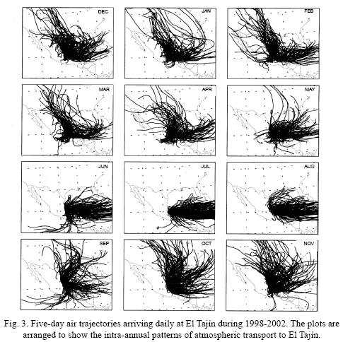
The vertical position of air parcels along their trajectories provides additional insight regarding the potential for upwind source regions to contribute contaminants to downwind receptors (Miller, et al., 2002). The mean vertical position of air parcels en route to El Tajín is shown in Figure 4b. From June–August, when the direction of multi–day air transport is almost exclusively easterly, air tends to remain at altitudes between 200–600 m msl (pressures between 980 and 940 hPa) during the entire five–day transit to El Tajin. Air transport at these low altitudes increases the likelihood that significant upwind source regions will contribute contaminants to be carried downwind to the receptor. In the case of El Tajin, significant upwind source regions during these months include Cantarell offshore oil fields in the southern Gulf of México and the onshore petroleum facilities at Atasta and Dos Bocas in the southwest Yucatán peninsula (Fig. 1). During the rest of the year (September–May) trajectory altitudes are considerably higher, reaching as high as 800 m msl (920 hPa) and 1600 m msl (840 hPa) for air parcels located one day and five days, respectively, upwind of El Tajín. Some of this increase in transport altitude is due to topography, as the Mexican Plateau reaches 1,500 m msl (850 hPa) and covers much of the country's interior. However, much of the higher altitude transport (see, for example, the northerly trajectories in the September–November panels in Fig. 3) does not pass over the plateau. Trajectory passage at higher altitudes decreases the likelihood of contaminant contributions from upwind source regions, due to the greater potential for dilution over larger air volumes.
4.2 Long–range transport corresponding to precipitation acidity measurements at El Tajín
In order to gain insight on possible relationships between air transport pathways and precipitation acidity, we examined trajectories corresponding to each of the 40 precipitation events measured at El Tajín during August 2002–January 2003 (Bravo et al, 2003). We first considered the representativeness of each event's trajectory using a spatial ensemble technique (Kahl, 1993). This technique assesses the divergence among trajectories arriving at multiple locations surrounding the location of interest. Substantial divergence indicates a large degree of horizontal wind shear, thus reducing the representativeness of the central trajectory (Fig. 5a). Twenty–one events were found to have representative, non–divergent trajectories. As would be expected from the long–range transport climatology shown in Figure 3, trajectories for most events depicted air transport from the northerly or easterly directions. In fact, no clear relationship between precipitation acidity (pH) and trajectory path was evident. In several cases, trajectories corresponding to events with varying levels of acidity were nearly identical (Figs. 5b, c). A relationship between precipitation pH and trajectory path was similarly absent when trajectories were calculated using a higher–resolution (80 km) meteorological data set (Black, 1994).
4.3 Local influences
In addition to the large–scale meteorological controls discussed above, winds at El Tajín are also influenced by the sea/land breeze circulation. The reduced heat capacity of soil relative to that of water creates a strong horizontal temperature gradient across the coastline. The temperature gradient, directed onshore during the day and offshore at night, creates a horizontal pressure gradient that drives a sea/land breeze circulation, with land breezes at night and sea breezes during the day.
The diurnal variation of wind direction in the region of the El Tajín archaeological zone is shown in Figure 6. Local winds tend to be east–northeasterly in the afternoon/evening, from 1500–midnight local time (2100–0600 UTC). Over the next three hours the winds shift to north–northwesterly and persist from this direction for six hours until noon local time (1800 UTC). The early afternoon is another transition period with winds shifting back to east–northeasterly by 1500 local time (2100 UTC).
The relative abundance of sea breezes (easterly winds for 9 hours) as compared to land breezes (northerly winds for 6 hours) is likely a scale interaction phenomenon: whereas the sea/land breeze is forced by the symmetric diurnal variation in solar heating, the easterly winds driven by the large–scale pressure patterns are relatively unaffected by diurnal variability and are a nearly constant influence. Cloud cover, which peaks in the afternoon (Martinez et al., 1989) and reduces the land/sea temperature contrast, also helps to retard the development of the nighttime land breeze.
5. Discussion and conclusions
On an annual basis, both large–scale and local meteorological forcings in the region of the El Tajín archaeological zone favor transport from easterly and northerly sources. This is also true during the rainy season of May–October, in which 80% of the annual rainfall of 1200 mm occurs (Martínez, et al., 1989; Bryson and Hare, 1974).
Significant acid precursor emissions exist in both of these upwind directions (Fig. 1). A large area of active oil platforms is located in the Bay of Campeche, about 500 km east or one day upwind of El Tajín. These platforms, along with associated processing and shipping facilities and nearby onshore operations, account for 80% of México's national fossil fuel production and emit an estimated 660,000 tons of air pollutants annually, including 181,000 tons of SOx and 287,000 tons of non–methane hydrocarbons (Villaseñor et al., 2003). The most abundant emissions are hydrocarbons and SO2, but significant amounts of NOX , CO, H2S and particulates are also released. In addition, a large electric power plant located in Tuxpan, 30 km north of El Tajín, is a potential source of acid precursor emissions. This nearby facility may be an important contributor to dry deposition at El Tajín. Farther to the north, the industrial cities of Tampico, Monterrey, and Brownsville/Matamoros may contribute additional contaminants. Other possible sources include oil refineries located in the nearby town of Poza Rica and throughout México's Gulf coast.
We have attempted to characterize atmospheric transport to the El Tajín archaeological zone, an important Mesoamerican heritage site. While our focus has been on meteorological processes, it is also of interest to examine possible relationships between transport and precipitation acidity.
In the present study we found no clear relationship between transport pathway and precipitation acidity for 21 rain events at El Tajín. This observation may be due to the abundance of upwind acid precursors emissions along both principal wind directions. The persistent easterly winds transport air from the vicinity of México's petroleum operations. Northerly winds, common in the morning due to the sea breeze circulation and during the winter months due to the larger–scale influence of the North American anticyclone, carry air from the direction of the Tuxpan power plant and several industrial cities.
The sampling of precipitation at El Tajín is an ongoing effort. Once the number of available samples reaches a statistically adequate level, a future study will attempt to quantify the relationship between transport and precipitation chemistry.
Acknowledgements
The authors wish to thank Dr. Yurgen Brugermann, responsible for the restoration project of the El Tajín archaeological zone; Alejandro Santes, responsible for sampling at El Tajín; and Dr. Víctor Magaña Rueda for his valuable comments and suggestions. Support for this project was provided by the U.S. Fulbright Program, the Mexican Fulbright Commission (COMEXUS), and Programa de Apoyo a Proyectos de Investigación e Innovación Tecnológica (PAPIIT) from the Dirección General de Asuntos del Personal Académico (DGAPA–UNAM).
References
Black T. L., 1994. The new NMC mesoscale Eta Model: Description and forecast examples. Wea. Forecasting 9, 265–278. [ Links ]
Bravo A. H., A. R. Soto, M. I. Saavedra, R. Torres, M. Granada and P. Sánchez, 1998. Acid rain in Mexico. Case: Maya monuments. In: Air Pollution VI (Advances in Air Pollution). (C. A. Brebbia, C. F. Ratto and H. Power, Eds.) WIT Press, Boston, 661–674. [ Links ]
Bravo H., R. Soto, R. Sosa, and P. Sánchez A., 2003. Efecto de la lluvia ácida en el material constructivo de los monumentos mayas mexicanos. Ingeniería, Investigación y Tecnología 4, 195–205. [ Links ]
Bravo H., R. Soto, R. Sosa, P. Sánchez, J. Alarcon, J. Kahl and B. Ruiz, 2006. Effects of acid rain on building material of the El Tajín archaeological zone. Environ. Pollut. 144, 655–660. [ Links ]
Bryson R. and F. K. Hare (Eds.), 1974. Climates of North America. Elsevier, New York, 420 pp. [ Links ]
Camuffo D., 1992. Acid rain and deterioration of monuments: How old is the phenomenon? Atmos. Environ. 26B, 241–247. [ Links ]
Guerrero Villalobos G., A. Jaime P. y J. Espinosa González, 2003. Manejo de información sinóptica histórica. Servicio Meteorológico Nacional, México, 11 pp. [ Links ]
Harris J., 2004. Atmospheric transport. In: Summary Report 27. (R. C. Schnell, A. Bugle and R. Rosson, Eds.), Climate Monitoring and Diagnostic Change Laboratory, NOAA, Boulder, CO, 103 pp. [ Links ]
Harris J. M. and J. D. W. Kahl, 1994. Analysis of 10–day isentropic flow patterns for Barrow, Alaska: 1985–1992. J. Geophys. Res. 99(D12), 25845–25855. [ Links ]
Harris J. M., R. Draxler and S. J. Oltmans, 2005. Trajectory model sensitivity to differences in input data and vertical transport method. J. Geophys. Res. 110, D14109. [ Links ]
Heckel P. F., T. C. Keener, M. Lu and H. Bravo Álvarez (Eds.), 2007. A summary of the International Workshop on the Influences of Air Quality on the Mayan Heritage Sites in Mesoamerica. Environmental Manager, February, 24–30. [ Links ]
Kahl J. D. W., 1993. A cautionary note on the use of air trajectories in interpreting atmospheric chemistry measurements. Atmos. Environ. 27A(17/18), 3037–3038. [ Links ]
Kahl J. D. and P. J. Samson, 1986. Uncertainty in trajectory calculations due to low resolution meteorological data. J. Climate Appl. Meteorol. 25(12), 1816–1831. [ Links ]
Kalnay E, M. Kanamitsu, R. Kistler, W. Collins, D. Deaven, L.Gandin, M. Iredell, S. Saha, G. White, J. Woollen, Y. Zhu, M. Chelliah, W. Ebisuzaki, W. Higgins, J. Janowiak, K. C. Mo, C. Ropelewski, J. Wang, A. Leetmaa, R. Reynolds, R. Jenne and D. Joseph, 1996. The NCEP/NCAR 40–year reanalysis project. Bull. Amer. Meteorol. Soc. 77, 437–471. [ Links ]
Tejeda–Martínez A., F. Acevedo and E. Jáuregui, 1989. Atlas climático del estado de Veracruz. Universidad Veracruzana, Xalapa, 150 pp. [ Links ]
Miller J. E., J. D. W. Kahl, F. Heller and J. M. Harris, 2002. A three–dimensional residence–time analysis of potential summertime atmospheric transport to Summit, Greenland. Annals of Glaciology 35, 403–408. [ Links ]
Persson A. and F. Grazzini, 2005. User Guide to ECMWF forecast products. Meteorological Bulletin M3.2, European Centre for Medium Range Weather Forecasts, Reading, UK, 162 pp. [ Links ]
Schultz D. M., W. E. Bracken and L. F. Bosart, 1998. Planetary– and synoptic–scale signatures associated with Central American cold surges. Mon. Wea. Rev. 126, 5–27. [ Links ]
Simmons A. J. R., R. Mureau and T. Petroliagis, 1995. Error growth and estimates of predictability from the ECMWF forecasting system. Q. J. R. Meteorol. Soc. 121, 1739–1771. [ Links ]
Stohl A., 1998. Computation, accuracy and applications of trajectories: A review and bibliography. Atmos. Environ. 32, 947–966. [ Links ]
Villaseñor R., M. Magdaleno, A. Quintanar, J. C. Gallardo, M. T. López, R. Jurado, A. Miranda, M. Aguilar, L. A. Melgarejo, E. Palmerín, C. J. Vallejo and W. R. Barchet, 2003. An air quality emission inventory of offshore operations for the exploration and production of petroleum by the Mexican oil industry. Atmos. Environ. 37, 3713–3729. [ Links ]

