


Servicios Personalizados
Revista
Articulo
 Inglés (pdf)
 Artículo en XML
 Referencias del artículo
 Enviar artículo por email
Indicadores
-
 Citado por SciELO
 -
 Accesos
Links relacionados
-
 Similares en
SciELO
Similares en
SciELO
Compartir

 Permalink
Atmósfera
versión impresa ISSN 0187-6236
Atmósfera vol.20 no.3 Ciudad de México jul. 2007
Prediction of binary tropical cyclones path on northeastern Pacific Ocean
E. BUENDÍA, O. DELGADO, F. VILLICAÑA, E. AZPRA
Centro de Ciencias de la Atmósfera, Universidad Nacional Autónoma de México
Circuito Exterior, Ciudad Universitaria, México, D. F., 04510, México
Corresponding author: E. Buendía; e–mail: buendia@servidor.unam.mx
G. SALGADO.
Instituto de Astronomía y Meteorología, Universidad de Guadalajara,
Guadalajara, Jalisco, México
Received March 10, 2005; accepted January 17, 2007
RESUMEN
En este artículo, se presentan algunos resultados de la predicción numérica de la trayectoria de ciclones tropicales binarios (o sistemas binarios). Los sistemas analizados se presentaron entre 1984 y 2005, al sur de 20° latitud Norte en el Océano Pacífico nororiental adyacente a México. En esta zona, es común que los ciclones tropicales estén acompañados por agrupaciones nubosas u otro ciclón tropical, que podría ser un sistema convectivo de mesoescala (MCS), una depresión tropical, una tormenta tropical o un huracán, que establecen una interacción que puede afectar su trayectoria típica. Al simular un sistema binario en este trabajo, la habilidad del modelo de predecir la trayectoria de este tipo de ciclones tropicales fue mejorada. En todos los casos, la costa occidental de México fue afectada por este tipo de sistemas.
ABSTRACT
In this article, some results of numerical prediction of binary tropical cyclones (or binary systems) paths are presented. The analyzed systems were produced between 1984 and 2005, southward of 20° North latitude on northeastern Pacific Ocean adjacent to México. In this zone, it is common that tropical cyclones be accompanied by cloud clusters or another tropical cyclone that might be a mesoscale convective system, (MCS), a tropical depression, a tropical storm or a hurricane, establishing an interaction that is able to affect their typical tracks. When simulating a binary system in this work, the ability of the model to predict the path of this kind of tropical cyclones was improved. In all cases, western coast of México was affected by this kind of systems.
Keywords: Binary system, numerical prediction, trajectory, México.
1. Introduction
Since the second decade of last century, Fujiwhara (1921, 1923) began the study of binary vortexes, manifesting that they spin on a counterclockwise sense, establishing a mutual attraction, until merging and forming a bigger and more intense vortex. This behavior is known as Fujiwhara effect. Afterwards, in other studies (Brand, 1970; Jarrel et al., 1978 and Neumann, 1982), it was determined that this effect not always is fulfilled in the atmosphere, according to the observations and predictions executed for the northwestern Pacific Ocean. In 1993 Lander and Holland added new facts about the Fujiwhara effect, postulating that binary tropical cyclonic vortexes can interrupt their interactions due to the influence of other atmospheric systems.
The study of binary cyclones was initiated in México since 1996, with the purpose of improving the quality of hurricane path predictions (Buendía et al., 2004), given the non–satisfactory results achieved when these cases were made in real time. It could be observed that the anomalous movement of a tropical cyclone accompanied by mesoscale convective system was not detected by the model until introducing a binary system in the initial data field.
2. Methodology
When a tropical system becomes tropical depression, tropical storm or hurricane and its position is reported accompanied by other outstanding convective disturbances, it is not clear if some of these disturbances have the possibility to have binary interaction with the cyclone, so that, the forecaster must determine through the satellite image analysis which of them is interacting with the cyclone. This interaction is detected by observing the satellite imagery sequences, received every 30 minutes prior to the forecast confection. Throughout them, Fujiwhara effect can be observed, therefore, when rawin–sounde data at 0000 UTC and 1200 UTC are available, several analyses can be accomplished, including the position of the MCS within the geopotential height fields observed at levels of 700, 500 and 250 Hpa. This kind of interaction, most frequent upon the north–eastern Pacific Ocean, can be observed in Table I, where tropical binary cyclones developed within the period 1984–2005 are shown. The first and second columns correspond to the pair of tropical cyclones, the third column indicates the years when they happened and in the fourth one are indicated the conditions or developing features of both tropical cyclones, when their interaction was initiated.

In this article will be presented the results of the application of numerical predictions for the following cases of binary systems:
a) A tropical MCS interacting with another MCS that completes the Fujiwhara effect (1931). As a result, a more intense tropical cyclone is finally developed (Alma in 1996).
b) A tropical storm (Norman in 1996) interacting with a MCS, where this last element escaped from the system due to the interaction with a through, which constitute an example of rupture of the interaction between binary cyclones (Lander and Holland, 1993).
c) In order to know circumstances the binary tropical cyclones developed southward from 20° North latitude would not affect Mexican coasts, several experiments were made with binary systems sown within historical geopotential height fields.
3. The model
In order to accomplish the tropical cyclone path prediction, it was used a filtered baroclinic model solved on a Mercator projection of the geographic area corresponding to Region IV. The squared mesh consists of 69 x 77 reticular points in intervals of 108 kilometers with east–west cyclic boundary conditions. For north–south boundary conditions it was considered that the stream functions are preserved constants at 750, 500 and 250 millibar levels (Buendía et al, 1981 and 1993). The final equations are:


Where F1 = Ψ250 + Ψ750, F2 = Ψ250 – Ψ750, Ψ250 and Ψ750 are the stream functions in 250 and 750 millibar levels, respectively J and  represent respectively the Jacobian and Laplacian operators, m is the scale factor of Mercator projection, λ2 = f 20 /σ(Δp)2 with λ-1 is called the radius deformation, f0 is the Coriolis parameter at 30° North latitude, s is static stability parameter and Δp = 500 Hpa. Finally ∂/∂Δ is the local variation expressed in finite differences advanced in the first time step and centered in the subsequent ones, with Δt minutes, (Buendía et al., 1990 and 1995).
4. Outputs
In Figure 1a, is shown the infrared satellite image of June 20/1200 UTC, 1996 when tropical storm Alma was localized, about 450 km south southeastward off Acapulco as a MCS within the intertropical convergence zone (ITCZ) (Avila, 1996), that was interacting with another vortex located about 630 kilometers southeastward off Alma. In few hours, binary circulation generated a tropical depression and 24 hours later it became into a tropical storm, having the shape shown in Figure 1b corresponding to infrared satellite image received on June 21/1200 UTC, 1996.

The analyses of this situation provided the initial conditions for solving the model. Figure 2a shows the 700 Hpa observed geopotential height field of June 21/1200 UTC, 1996 and also it can be seen the evolution of the Fujiwhara effect, since an hour and a half after running the model (Fig. 2b), the counterclockwise circulation of the whole system has set the axis joining the cyclonic vortexes at east–west position. This position was detected in the infrared satellite image received on June 22/0615 UTC at the University of Hawaii's station (Fig. 2c). The model simulates the vortexes merger, in the three hours results (Fig. 2d), as it is observed in Figure 2e that shows the infrared satellite image of June 23/1200 UTC; afterwards, the tropical storm Alma moved parallel to the littoral.
The trajectory forecasted by the model fits adequately to the real one; however, the model run is faster than the actual displacement.
For the second kind of interaction, the example exposed in this article is the prediction of the binary system formed by the tropical storm Norman and another MCS on September 20/1200 UTC, 2000, which is observed in Figure 3a and 3b, showing respectively an infrared satellite image and the observed 700 Hpa geopotential height field.

In the infrared satellite image of Figure 3a, it can be appreciated the tropical storm Norman located westward off Colima and Jalisco states, and the MCS was located southwestward off Guerrero and Oaxaca states. This binary system did not complete the Fujiwhara effect, since an escape was produced, according to Lander and Holland (1993). That is Fujiwhara effect was interrupted, as observed in Figure 4 with the prediction made by the model, printed every 12 hours.
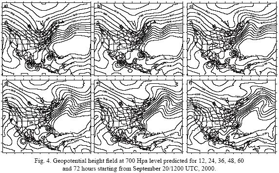
The forecast of the geopotential height field at 700 Hpa level valid for 12 hours could detect the Fujiwhara effect, which spun the cyclonic vortexes in a counterclockwise sense, making the distances between them decrease slightly. Twelve hours latter, the model run showed that the MCS was getting away itself from tropical storm Norman, because of its interaction with a through that was moving eastward, in such a way that in 36 hours forecast the MCS totally escaped from the influence of Fujiwhara effect, and it may be seen the tropical storm Norman isolated. Later, this tropical cyclone continued moving parallel to the Mexican west coast towards Baja California Peninsula.
The predictions valid for 60 and 72 hours were erroneous, because the tropical storm Norman really kept moving parallel to the continent, (Fig. 4). The next day forecast, not shown in this article, detected this behavior of the storm.
The conclusion that has been obtained, after examining the model runs for each one of the cases presented in Table I, is that at least one of the binary system elements affected the western coast of México, as it is observed in Figure 5, where real tracks of these systems have been graphically displayed.

Finally, the third part of this paper, tries to find out on what circumstances binary systems do not penetrate to Mexican coasts. All cases were reanalyzed by means of the accomplishing of 87 runs of the model with the observed geopotential height field at 750, 500 and 250 Hpa levels, where the binary vortexes were bogus. Two outputs of these experiments are shown in Figure 6a and 6b.
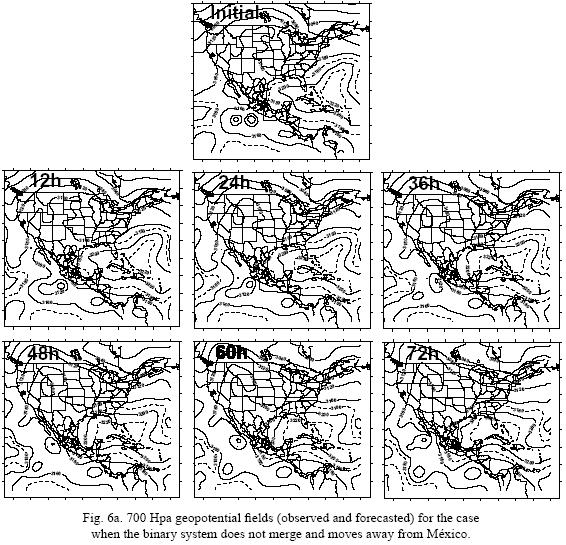

Figure 6a, represents the cases when the quasi–stationary Atlantic anticyclone moves on westward, forcing a displacement of the binary system in the same direction, bringing about the escape or dissolution of Fujiwhara merger, putting away a vortex of the binary system from coasts of México, as it is observed in forecasts every 12 hours in this figure.
In Figure 6b, the experiment consisted in bogusing the vortexes closer and with less intensity. In this case, apparently also will be produced an escape 36 hours ahead off the model run, but it did not happen; however, the vortexes merger was reached 42 hours after running the model, so that the forecast valid for 48 hours shows the tropical storm located southwestward from its initial position, and initiates an interaction with a MCS that at the beginning of the model run was located eastward off the binary system, as it may be seen in the predictions valid every 12 hours of Figure 6b. In both cases, binary systems get apart from Mexican coasts and do not penetrate to the country.
To México, these results are very important, since they provide new elements to Mexican meteorologists that begin to overcome conclusions from Jarrel et al. (1978) and Lester et al. (1997) referred to how difficult is to achieve acceptable results in predicting binary systems, and they call up the attention about the high probability of having these combinations or interactions between tropical cyclones that land into México.
5. Conclusions
The results evidence that making use of a simple baroclinic model, it is possible to forecast the binary tropical system paths, including the merger or escape of the vortexes.
The interaction between binary vortexes contributes to generate, besides the environmental conditions, a northwestward movement of them, with or without merger.
All the examined cases of binary tropical cyclones generated southward of 20° North latitude on the northeastern Pacific Ocean from 1984 to 2005, penetrated the west coast of México, either when it was produced the merger or the escape off the Fujiwhara effect, and then they moved parallel to the continent. Only tropical storm Rosa displaced itself directly towards the west coast, driven by a through (Fig. 5).
The model yields satisfactory outputs because it is able to detect the attraction and counterclockwise rotation of the cyclonic vortexes forming the binary systems, which modifies the typical northwestward trajectory of the main storm, including if the vortexes merger occurs or not. In both cases, either the resulting cyclone or the cyclonic vortex that was initially located eastward off the binary system usually penetrates into the continent, and tends to move parallel to the coast, or with the eye over the continent or over the ocean. This result is illustrated by the tropical storm Alma.
If Fujiwhara circulation stops, one of the vortexes also moves parallel to the west coast, as tropical storm Norman did. It is true only when the semipermanent Atlantic anticyclone maintains its typical position.
The bogus tropical binary cyclones do not make landfall into México when the quasi–stationary Atlantic anticyclone displaces westward (Buendía et al., 2004).
Acknowledgments
The authors express their gratitude to Rafael Patiño, Alfonso Salas and Delibes Flores for their cooperation.
References
Avila L., 1996. Hurricane Alma 20–27 June 1996. Preliminary Report TPC/NHC, Microsoft Internet. 2–7. [ Links ]
Brand S., 1970. Interaction of binary tropical cyclones of the western North Pacific. Ocean J. Appl. Meteor. 9, 433–441. [ Links ]
Buendía E., O. Delgado, F. Villicaña, E. del Valle, R. Patiño y A. Gallegos, 1984. El modelo baroclínico simple y su resolución en la Cuarta Región. Rev. Geofísica, Institutto Panamericano de Geografía e Historia. 21, 125–145. [ Links ]
Buendía E., F. Villicaña, O. Delgado, E. del Valle and F. Gómez, 1993. On the trajectory of cyclones likely to affect the Mexican Republic. Atmósfera 5, 21–30. [ Links ]
Buendía E., O. Delgado, A. Meulenert and C. Vázquez. 2004. Interaction of binary cyclones in northeastern Pacific Ocean, American Meteorol. Soc. 26th Conference on Hurricanes and Tropical Meteorology, 483–484. [ Links ]
Dong K. and C. Neumann, 1983. On the relative motion of binary tropical cyclones. Mon. Wea. Rev. 111, 945–953. [ Links ]
Fujiwhara S., 1921. The natural tendency towards symmetry of motion and its application as a principle of motion. Q. J. R. Meteorol. Soc. 47, 287–293. [ Links ]
Fujiwhara S., 1923. On the growth and decay of vortical systems. Q. J. R. Meteorol. Soc. 49, 75–104. [ Links ]
Fujiwhara S., 1931. Short note on the behavior of two vortices. Proc. Phys. Math. Soc. Japan, Ser. 13, 106–110. [ Links ]
Holland G. J. and G. S. Dietachmayer, 1993. On the interaction of tropical–cyclone–scale vortices. III: Continuos barotropic vortices. Q. J. R. Meteorol. Soc. 119, 1381–1389. [ Links ]
Jarrel J., D. Brand and S. Nicklin, 1978. An analysis of western North Pacific tropical cyclone forecast errors. Mon. Wea. Rev. 106, 925–937. [ Links ]
Lander M. and G. J. Holland, 1993. On the interaction of tropical–cyclone–scale vortices. Observations. Q. J. R. Meteorol. Soc. 119, 1347–1361. [ Links ]
Lester E. C. III, M. A. Boothe and R. L. Elsberry, 1997. Obsevational evidence for alternate modes of track–altering binary tropical cyclone scenarios. Mon. Wea. Rev. 125, 2094–2111. [ Links ]
Neumann C. J., 1982. Trends in forecasting the tracks of tropical Atlantic cyclones. Bull. Amer. Meteor. Soc. 62, 1472–1485. [ Links ]
Ritchie E. A. and G. J. Holland, 1993. On the interaction of tropical–cyclone–scale vortices. II: Discrete vortex patches. Q. J. R. Meteorol. Soc. 119, 1363–1379. [ Links ]
Wang Y. and G. J. Holland, 1995. On the interaction of tropical–scale–vortices. IV: Baroclinic vortices. Q. J. R. Meteorol. Soc. 121, 95–126. [ Links ]

