


Servicios Personalizados
Revista
Articulo
 Inglés (pdf)
 Artículo en XML
 Referencias del artículo
 Enviar artículo por email
Indicadores
-
 Citado por SciELO
 -
 Accesos
Links relacionados
-
 Similares en
SciELO
Similares en
SciELO
Compartir

 Permalink
Atmósfera
versión impresa ISSN 0187-6236
Atmósfera vol.16 no.1 Ciudad de México ene. 2003
Progress in Pan American CLIVAR Research: The North American Monsoon System
R. Wayne Higginsa Art Douglasb, Andrea Hahmannc, E. Hugo Berberyd, Dave Gutzlere, Jim Shuttleworthf, David Stensrudg, Jorge Amadorh, Rit Carbonei, Miguel Cortezk, Michael Douglasg, Rene Lobatoj, Jose Meiting, Chester Ropelewskil, Jae Schemma, Siegfried Schubertm, Chidong Zhangn
a Climate Prediction Center, NCEP/NWS/NOAA, Camp Springs, MD.
b Atmospheric Sciences Dept., Creighton University, Omaha, NE.
c Institute of Atmospheric Physics, University of Arizona, Tucson, AZ.
d Dept. of Meteorology. University of Maryland, College Park, MD.
e Earth & Planetary Sciences Dept. University of New Mexico, Albuquerque, NM.
f Dept. of Hydrology and Water Resources, University of Arizona, Tucson. AZ.
g National Severe Storms Laboratory, NOAA, Norman, OK.
h University of Costa Rica, San José, Costa Rica.
i National Center for Atmospheric Research, Boulder, CO.
j Instituto Mexicano de Tecnología del Agua, Jiutepec, Morelos, México.
k Servicio Meteorológico Nacional, México.
l IRI for Climate Prediction, LDEO of Columbia University, Palisades, NY.
m Data Assimilation Office, NASA/GSFC, Greenbelt, MD.
n RSMAS, University of Miami. Miami FL.
Corresponding author:
Dr. R. W. Higgins,
Analysis Branch, Climate Prediction Center,
NOAA/MWS/MCKP, Camp Springs,
MD 2071G, U.S.A.
Email: wayne.higgins@noaa.gov
Received January 14, 2002; accepted September 12, 2002
RESUMEN
La meta general de la Investigación Panamericana CLIVAR sobre el Sistema Monzónico Norteamericano es la determinación de las fuentes y límites de predictabilidad de la precipitación de la estación caliente en Norteamérica, con énfasis en escalas de tiempo que van hasta la estacional e interanual. Para alcanzar esta meta se han identificado varios objetivos de investigación incluyendo: 1. un mejor entendimiento de las componentes clave del sistema monzónico y su variabilidad espacial y temporal, 2. una mejor comprensión del papel de este sistema dentro del ciclo hidrológico global, 3. datos observacionales mejorados y 4. simulación y predicción mensual y estacional mejoradas del monzón y los recursos hidráulicos regionales. El propósito de este artículo es revisar el avance reciente que se ha hecho para alcanzar estos objetivos y resaltar algunos de los desafíos futuros basados en las deficiencias de nuestra comprensión.
ABSTRACT
The overall goal of Pan American CLIVAR Research on the North American Monsoon System is to determine the sources und limits of predictability of warm season precipitation over North America, with emphasis on time scales ranging up to seasonal-to-interannual-. To achieve this goal, several research objectives have been identified including (1) a better understanding of the key components of the monsoon system and their temporal and spatial variability, (2) a better understanding of the role of this system within the global water cycle, (3) Improved observational data sets, and (4) improved simulation and monthly-to-seasonal prediction of the monsoon and regional water resources. The purpose of this paper is to review the recent progress made towards achieving these objectives and to highlight some of the future challenges based on gaps in our understanding.
Key words: monsoon, precipitation.
1. Introduction
A fundamental and necessary first step towards improving warm season precipitation prediction is the clear documentation of the major elements of the warm season precipitation regime and their variability within the context of the evolving land surface-atmosphere-ocean annual cycle. Monsoon circulation systems, which develop over low latitude continental regions in response to thermal contrast between the continent and adjacent oceanic regions, are major components of continental warm-season precipitation regimes (e.g., see the review by Webster, 1987). These systems are characterized by seasonal reversals of the circulation and precipitation regimes (e.g., Ramage, 1971) with many links to weather and climate fluctuations (e.g., Kiladis and van Loon, 1988; Webster and Yang, 1992).
Over southwestern North America there is a continental-scale monsoon-like circulation regime that is associated with the summertime precipitation climatology of the region. This North American Monsoon System (NAMS) provides a useful framework for describing and diagnosing warm-season climate controls and the nature and causes of year-to-year variability (e.g., Okabe, 1995; Higgins et al, 1997b). A schematic summarizing some of the key elements of the NAMS during its mature phase is shown in Figure 1. The schematic emphasizes; the controlling influences of the large-scale tow-level flow around the subtropical high pressure centers (indicated by "H") and the large-scale upper-level flow around the monsoon anticyclone (indicated by "A").
Heating over the elevated terrain of Mexico and the western United States (U. S.) plays a major role in the development and evolution of the NAMS, in a manner similar to what is observed with the Tibetan Plateau and the South Asian Monsoon (e.g., Tang and Reiter, 1984) and with the Bolivian Altiplano and the South American Monsoon (e.g., Johnson, 1976). While the NAMS is less impressive than its sisters, it still has a tremendous impact on local climate, accounting for a large fraction of the total precipitation across the southwest U.S. and northwestern Mexico (e.g., Higgins et al, 1997b; Barlow et al., 1998).
Attempts to describe and understand the major elements of the NAMS and their variability have been hampered to a large extent by the lack of adequate in situ and satellite data. Over the last two decades operational data assimilation systems have provided global gridded atmospheric analyses necessary for climate studies of phenomena such as the monsoon. However, operationally mandated changes in the assimilation systems have introduced in homogeneities in the data record that have led to difficulties in defining anomalies (e.g., Trenberth and Olson, 1988). In addition, the horizontal resolution of the global data assimilation systems often precludes capturing many of the mososcale features that may be important to the monsoon system. Clearly, advances in describing and modeling the warm season precipitation regime over North America require homogeneous datasets. Recent multi-year global analyses produced with fixed assimilation systems, such as the NCEP/NCAR reanalysis (Kalnay et al., 1996), are a major step forward in this regard.
Recent advances, in observing, diagnosing and modeling the NAMS and its variability are due in large part to several special programs that have focused on these issues, including the Pan American Climate Studies (PACS) program, U.S. CLIVAR Pan American research, the CLIVAR/VAMOS program and the PACS/GCIP Warm Season Precipitation Initiative. One purpose of thin paper is to review said progress.
Despite this progress, many challenges remain. The structure of the low-level circulation that supply moisture from the tropics along the Gulf of California and from the Gulf of Mexico, the precipitation patterns and associated divergent circulations, and the moisture and energy budgets over the core North American monsoon region remain largely invalidated and incompletely understood. Dynamical understanding of the seasonal march of rainfall and its variability over Mexico and Central America is incomplete. The meteorological observation and analysis system for this region remains insufficient to describe relationships among low- frequency anomalies of the warm season precipitation regime and the nature and frequency of significant weather events such as hurricanes and floods. Thus, a second purpose of this paper is to discuss some of the future challenges associated with gaps in our understanding as a framework for future research activities od the NAMS.
The life cycle and large-scale features of the NAMS are discussed in section 2. Variability of the NAMS is discussed in section 3, while modeling and predictability of the NAMS are discussed in section 4. Future challenges and plans for process studies aimed at filling gaps in our knowledge are given in section 5.
2. The climatological mean state
2.1 Life cycle
The life-cycle and large-scale features oF the NAMS can be described using terms typically reserved for the much larger Asian Monsoon system; that is, we can characterize the life-cycle in terms of development, mature and decay phases. The development (May-June) phase is characterized by a period of transition from the cold Season circulation regime to the warm season regime. In southern Mexico May marks the beginning of the rainy season while in the U.S. Desert Southwest May and early June are typically rainless (and Englehart, 1996 and Higgins et al., 1999). The northward penetration of the summer rainy season is accompanied by a decrease in mid-latitude synoptic-scale transient activity over the conterminous: U. S. and northern Mexico as the extratropical storm track weakens and migrates poleward to a position near the Canadian border by late June (e.g., Whittaker and Horn, 1981; Parker et al, 1989), During this time there are increases in the amplitude of the diurnal cycle of precipitation (e.gr, Wallace, 1975; Higgins et al.. 1996) and in the frequency of occurrence of the Great Plains low-level jet (e.g., Bonner, 1968; Bonner and Paegle, 1970; Augustine and Caracena, 1996; Mitchell et al., 1995; Helfand and Schubert, 1995: Higgins et al., 1997a).
The development of the North American Monsoon (Douglas et al., 1993; Stensrud et al, 1995; Adams and Comrie, 1997) is characterized by heavy rainfall in late May or early June over southern Mexico, which quickly spreads northward along the western slopes of the Sierra Madre Occidental into Arizona and New Mexico by early July (Fig. 2). Precipitation increases over northwestern Mexico coincide with increased vertical transport of moisture by convection (Douglas et. al., 1993) and southerly winds flowing up the Gulf of California (Baden-Dagan et al., 1991). The onset is usually sudden, with the weather in the monsoon region changing abruptly from relatively hot, dry conditions to cool, rainy ones. Mean monthly rainfall totals during the monsoon season exceed 30 cm along much of the western slopes of the Sierra Madre Occidental, causing the vegetation characteristics in this region to evolve from near desert conditions to those typical of a tropical rain forest within six to eight weeks (Douglas, 1993).
Increases in precipitation over the southwestern U. S. occur abruptly around the beginning of July (Mock, 1996: Higgins et al., 1997b) and coincide with the development of a pronounced anticyclone at the jet stream level (e.g., Okabe 1995), the development of a thermally induced trough in the desert Southwest (Tang and Reiter, 1984; Rowson and Colucci, 1992), northward displacements of the Pacific and Bermuda highs (Carleton, 1986, 1987), the formation of southerly low-level jets over the Gulf of California (Carleton, 1986; Douglas, 1995), the formation of the Arizona monsoon boundary, and increases in eastern Pacific SST gradients (Carleton et al., 1990), and increased variability of the easterly low-level jet and convective activity in the Caribbean (Amador, et al., 2000).
From June to July there is also an increase in SLP over the southwestern U.S. (Okabe, 1995) and a general height increase in mid-latitudes associated with the seasonal heating of the troposphere. The largest increases in height occur over the western and southern U. S. and are likely related to enhanced atmospheric heating over the elevated terrain of the western U.S. and Mexico, and increased latent heating associated with the development of the Mexican Monsoon. The resulting middle and upper tropospheric "monsoon high" is analogous to the Tibetan High over Asia (e.g., Tang and Reiter, 1984) and the warm season Bolivian High over South America (e.g., Johnson, 1976).
During the mature (July-August-early September) phase the NAMS is fully developed and can be related to the seasonal evolution of the continental precipitation regime. The northern edge of the monsoon extends into Arizona and New Mexico (e.g., Douglas et al., 1993), but the rainfall is much lighter and more directly influenced by midlatitude effects in the Four Corners region of Arizona and New Mexico, The monsoon high is associated with enhanced upper tropospheric divergence in its vicinity and to the south, and with enhanced easterlies (or weaker westerlies) and enhanced monsoon rainfall (Douglas et al, 1993). To the north and east of the monsoon high, the atmospheric flow is more convergent at upper levels and rainfall diminishes from June to July in the increasingly anticyclonic westerly flow (e.g., Harman, 1991). Surges of maritime tropical air move northward along the Gulf of California and are linked to active and break periods of the monsoon rains over the deserts of Arizona and California (Hales, 1972; Stensrud et al, 1995). The mature phase has also been linked with increased upper-level tropospheric divergence and precipitation in the vicinity of an "induced" trough over the eastern U.S. (e.g., Higgins et. al., 1997b).
The decay (late September-October) phase of the NAMS can be characterized as broadly the reverse of the onset phase, although the changes tend to proceed at a slower rate. During this phase the ridge over the western U. S. weakens as the monsoon high retreats southward and precipitation diminishes. The decay phase is also accompanied by an increase in rainfall over much of the surrounding region (Okabe, 1995). Mexico's mean wettest month is September and this is due to the heavy rainfall observed south of a line from near Mazatlan to Brownsville, Texas. By the third week of September rainfall usually starts to decrease rather rapidly as the local seasonal heating component weakens. Days have become shorter and the vegetated land mass cannot heat up and sustain widespread convection.
2.2 Moisture source
Numerous authors have attempted to identify the primary source of moisture for the summer rains over the southwestern North America. Bryson and Lowry (1955) suggested that horizontal advection of moist air at middle levels from the east or southeast around a westward extension of the Bermuda high might explain the onset of summer rainfall over the southwestern U. S.; this was later corroborated by Sellers and Hill (1974). Several authors (Hales, 1972, 1974; Brenner, 1974; Douglas et al., 1993) expressed skepticism for this type of explanation since moisture from the Gulf of Mexico would first have to traverse the Mexican Plateau and Sierra Madre Occidental before contributing to Arizona rainfall. Rasmusson (1966, 1967, 1968) was among the first to show a clear separation between water vapor east of the continental divide, which clearly originates in the Gulf of Mexico / Caribbean Sea, and moisture over the Sonoran Desert that appears to originate in the Gulf of California. Schmitz and Mullen (1996) examined the relative importance of the Gulf of Mexico, the Gulf of California and the eastern tropical Pacific as moisture sources for the Sonoran Desert using ECMYVF analyses. They found that most of the moisture at upper levels over the Sonoran desert arrives from over the Gulf of Mexico, while most of the moisture at lower levels comes from the northern Gulf of California. Mean resultant surface winds across most of eastern and north central Mexico are SE, which supports the hybrid idea of Schmitz and Mullen (1996).
Berbery (2001) used analyses from the NCEP Eta Model Data Assimilation System to show that the diurnal cycle in moisture flux divergence over the core monsoon region is coupled to the diurnal cycle in the sea breeze / land breeze circulation. In particular, the afternoon seabreeze was associated with strong moisture flux divergence over the Gulf of California and strong moisture flux convergence along the west slopes of the Sierra Madre Occidental leading to intense afternoon and evening precipitation. At night the land breeze develops, leading to moisture flux convergence near the coastline and over the Gulf of California where morning precipitation often develops.
Moisture sources for the NAMS remain poorly resolved, due in large part to the complex topography and sparse upper air instrumentation across the NAMS domain and the importance of deep convection for vertical transport and moisture recycling. As suggested above, it is likely that water vapor advective fluxes from both the Pacific and Gulf of Mexico contribute to warm season precipitation across the NAMS domain, and batter determination of the mix of fluxes and the dynamical mechanisms that control advection of water from east and west will contribute to the predictability of the NAMS.
2.3 Continental-scale precipitation pattern
The onset of the summer monsoon rains over southwestern North America has been linked to a decrease of rainfall over the Great Plains of the U.S. (e.g., Tang and Reiter, 1984; Douglas et al., 1993; Mock, 1996; Higgins et al., 1997b) and to an increase of rainfall along the East Coast of the U S. (e.g., Tang and Reiter, 1984; Higgins et al, 1997b). In an EOF analysis of July rainfall for the U. S., Englehart and Douglas (1985) found that the first two modes of rainfall variability emphasize inverse relationships between rainfall in the Southwest and the northern and central Great Plains. Higgins et al, (1997b) showed that this continental-scale precipitation pattern (Fig. 3) is broadly consistent with changes in the tropospheric circulation and divergence fields (mean vertical motion). Barlow et al, (1993) found this to be a robust, climatological mean feature with deep diabatic healing patterns. Okabe (1995) has shown that phase reversals in this continental-scale precipitation pattern are related to the development and decay of the monsoon. These results suggest that links between the summer monsoon in southwestern North America and summertime precipitation in the Great Plains of the U. S, may have predictive value at the seasonal time scale.
Recently, Higgins et al, (1998) demonstrated that interannuat variability of the continental-scale precipitation pattern closely mimics the seasonal changes associated with the development of the monsoon suggesting that precipitation and hydrologic anomalies over much of the continent during the summer are strongly linked to the intensity of the monsoon and, in particular, to the intensity of the monsoon anticyclone over the southwest.
2.4 Mid-summer minimum
Douglas and Englehart (1996) demonstrated that a dominant feature of summer rainfall patterns in southern Mexico and Central America is an alternating wet-dry-wet period in the July-August-September time Frame. This pronounced double peak structure is clearly evident in observed precipitation and in diurnal temperature range equatorward of the Tropic of Cancer (Fig. 4), but the physical setting responsible for this variability within the monsoon season remains elusive us doe its interannual variability. The double peak structure in precipitation extends southwestward over the warm pool region of the eastern tropical Pacific. Recent evidence indicates that the trade winds, evaporation and precipitation patterns over the warm pool region modulate the sea-surface temperatures in a manner consistent with the double peak structure, hence the mid summer break (Magaña et al., 1999).
3. Variability
3.1 Interannual variability
There is a growing body of modeling and observational evidence that slowly varying oceanic boundary conditions (i.e., SST, sea ice) and land boundary conditions (e.g., snow cover, vegetation, and soil moisture) influence the variability of the atmospheric circulation on time scales up to seasonal and annual (e.g., Yasunari, 1990: Yasunari et al., 1991; Yasunari and Seki, 1992). Within the context of the NAMS, Higgins et al. (1998) showed that wet (dry) summer monsoons in the southwestern U.S. tend to follow winters characterized by dry (wet) conditions in the southwestern U.S. and wet (dry) conditions in the northwestern U.S. (Fig. 5). This association was attributed, at least in part, to the wintertime pattern of Pacific SST anomalies (SSTA) which provide an ocean-based source of memory of antecedent climate fluctuations.
A number of studies have considered the simultaneous relationship between SST in the tropical Pacific and NAMS rainfall, Harrington et al. (1992) found significant correlations between the phase of the southern oscillation and Arizona / New Mexico precipitation. Hereford and Webb (1992) suggested a relationship between increased summer precipitation in the Colorado plateau region and the warm phase of ENSO. During the summer season other studies have argued that more localized SSTA are important. Carleton et al. (1990) showed that the monsson in the southwest U.S. is negatively correlated with SSTA along the northern Baja coast while Huang and Lai (1998) found positive correlations with SSTA over the Gulf of Mexico. Ting and Wang (1997) found that SSTA in the North Pacific may also influence precipitation over the central U. S. Collectively these studies have demonstrated various connections between warm season precipitation and SST, but the fraction of the total variance explained in each case is rather small.
Another possibility is that both winter and summer precipitation regimes are influenced by coherent patterns of SSTA that persist from winter to summer. Douglas et al. (1982) and Namias et al. (1988) emphasized that persistent SSTA patterns in the North Pacific are often associated with persistent atmospheric teleconnection patterns. They identified the region in the midlatitudes of the central North Pacific (near 40° N) as being an important area where SSTA have an effect on circulation anomalies downstream over the U.S. Of particular relevance for this NAMS is the work of Carleton et al (1990) who demonstrated that anomalously wet (dry) summers in Arizona tend to follow winters characterized by the positive (negative) phase of the Pacific-North America tele-connection pattern. Mo and Paegle (2000) argue that the Pacific influence on the NAMS depends on the particular combination of tropical and extratropical SSTA patterns that persist from winter to summer.
Monsoonal rains are also influenced by changes in land-based conditions that provide memory of antecedent hydrologic anomalies. Observational and modeling evidence indicates that the springtime snowpack across Eurasia modulates the amplitude of the Asian monsoon rains in the following summer, such that heavy snowpack leads to a weak monsoon, and light snowpack leads to a strong monsoon (e.g., Barnett et al., 1989; Vernekar et al., 1995; Yang et al., 1996), Gutzler and Preston (1997) found an analogous relationship in North America such that excessive snow in the southern Rockies tends to be associated with deficient summer rainfall in the Southwest and deficient snowfall lends to be associated with abundant summer rain. This is consistent with the findings of Douglas (1988). in which May air temperatures in the central Rockies (a proxy for snow cover) was found to be negatively correlated with subsequent summer rainfall in the northwest Mexican states of Sonora and Chihuahua.
Seasonal weather prediction has also been shown to be dependent, at least in portions of the region, on the soil moisture at the beginning of the growing season (Pielke et al., 1999) and the feedback between vegetation growth and rainfall (Eastman et al., 2000, Lu et al., 2000). This feedback may explain why correlations between ocean SSTs and rainfall over the Great Plains and southwest U. S. deteriorate during the warm season (Castro et al., 2000a). The inclusion of models of the vegetation response to weather, and the subsequent feedback to rainfall and other weather variables, therefore, may improve seasonal weather prediction. To accomplish this goal, however, soil physics and vegetation dynamics must be included as seasonal weather variables in the same context as rainfall, temperature, and other atmospheric variables.
Complicating all these studies of NAMS interannual variability is the noncoherence of warm season precipitation anomalies across the NAMS domain. Gutzler (2000) showed that the interanuual variability of southwest U.S. summer rainfall anomalies could be divided into several coherent regional patterns. Rainfall in New Mexico and Arizona varied in statistically independent ways, suggesting that different factors might modulate seasonal anomalies in the western and eastern parts of the NAMS domain.
3.2 Decadal variability
Latif and Barnett (1996) discussed two types of decadal variability in the North Pacific that may be relevant for the NAMS. The first is associated with the climate shift in the North Pacific in the mid-1970s (e.g., Douglas et al., 1982; Trenberth and Hurrell. 1994: Miller et al., 1994: Graham et al., 1994) which many authors agree is a manifestation of atmospheric forcing driving ocean variations. The second type is more oscillatory, and involves unstable ocean-atmosphere Interactions over the North Pacific as originally hypothesized by Namias (1959). Namias argued that SSTA in the North Pacific influence the atmospheric transients, hence the mean westerly flow in such a way as to reinforce the original SSTA. Recent coupled GCM and observational studies (e.g., Latif and Barnett, 1994,1996) have implicated Namias's hypothesis in the decadal variability of the North Pacific-North American sector.
In a recent study Higgins and Shi (2000) argued that the summer monsoon in the southwest U.S. is modulated by Longer term (decade-scale) fluctuations in the North Pacific SSTs associated with the Pacific Decadal Oscillation (PDO). Relatively wet monsoons tended to occur during the negative phase of the PDO while relatively dry monsoons were more frequent during the positive phase of the PDO. This is consistent with the fact that El Niño (La Niña) events, which tend to favor relatively dry (wet) monsoons in Mexico, occur more frequently during the positive (negative) phase of the PDO- Higgins and Shi (2000) also found that the mechanism relating the North Pacific wintertime SST pattern to the summer monsoon appears to be via the impact of variations in the Pacific jet on west coast precipitation regimes during the preceding winter. This mechanism affects local land-based sources of memory in the southwestern U.S., which in turn influence the subsequent timing and intensity of the summer monsoon. These results arc consistent with recent results of Castro et al., (2000b).
The teleconnectivity of monsoon rainfall in Mexico with various large-scale climate indices appears to vary according to the phase of the PDO (Englehart and Douglas, 2001). During the positive phase of the PDO (warm SSTs off the West Coast, cold SSTs in the central North Pacific) rainfall over moat of Mexico exhibits strong negative relationships with ENSO. During the negative phase of the PDO relationships between Mexican rainfall and ENSO arc weak. However, in the negative phase of the PDO local climate indices become more prominent as potential predictors of regional rainfall in Mexico (e.g. continental ridge position and local SST fields). This shift to local teleconnection indices becoming more important suggests that local land-sea processes may play a larger role in shaping the monsoon in Mexico during periods when global SSTs and atmospheric circulation are less coupled.
Recent research has shown that low-frequency variability in U.S. summer rainfall is associated with multidecadal variability in the North Atlantic SST (Enfield et al., 2001). For example, the North Atlantic warming (roughly 1930-1965) included two of the most well known droughts (the 1930's Dust Bowl and the 1950s drought). The North Atlantic variability is also associated with important changes in the winter correlation patterns between U.S. rainfall and ENSO. Much of our empirical knowledge of ENSO rainfall effects over the U.S. has been obtained during the recent period of North Atlantic cooling (roughly 1969-1994). However, relatively little is known about now this low-frequency SST variability interacts with interannual fluctuations of the NAMS.
3.3 Intraseasonal variability
The intensity of the seasonal mean monsoon is influenced by the nature of Cha variability within the monsoon season. Previous attempts to relate rainfall anomalies for the monsoon season to the date of onset of the Indian monsoon (e.g., Dhar et al., 1980) have generally shown little relationship indicating that the intraseasonal variability of monsoon rainfall is quite large. A season with deficient monsoon rainfall does not imply an absence of rainfall for the whole season, but rather prolonged periods of reduced rainfall often referred to as "break" monsoons; prolonged periods of enhanced rainfall are referred to as "active" monsoons.
Tropical rainfall exhibits strong variability on sub-seasonal time scales throughout the global tropics- These fluctuations, which are also clearly evident in the tropical planetary-scale sea-level pressure field and in the winds over the western Pacific, often go through an entire cycle in 30-60 days, and are commonly referred to as intraseasonal oscillations or Madden-Julian Oscillations (MJO's) (Madden and Julian, 1971, 1972, 1994), There are distinct patterns of lower-level and upper-level atmospheric circulation anomalies which accompany the MJO-related patterns of tropical rainfall (e.g., Kayano and Kousky, 1999). These circulation features extend around the globe and thus provide important information regarding the regions of ascending and descending motion associated with particular phases of the oscillation.
Many studies have shown that the MJO strongly affects the NH winter jet stream and atmospheric circulation features over the North Pacific and western North America. During the NH summer the MJO has a modulation effect on tropical cyclone activity in the Indian, Pacific and Atlantic Ocean basins (e.g., Liebmann et al., 1994; Maloney and Hartmann, 2000a; Maloney and Hartniann, 2000b; Higgins and Shi, 2001). Higglins and Shi (2001) separated the dominant modes of intraseasonal and interannual variability of the NAMS in order to examine MJO-related and ENSO-related influences on monsoon precipitation. They found a strong relationship between the leading mode of intraseasonal variability of the NAMS, the MJO, and the points of origin of tropical cyclones In the Pacific and Atlantic basins (Fig. 6). They concluded that it is very important to monitor and predict MJO activity during the NH warm season, since this activity has profound implications for weather and short-term climate variability in the region.
In a regional study of western Mexico, Englehart and Douglas (2001) provide evidence for the prominent role that tropical storm activity plays in seasonal rainfall regimes. They show that for many locations in western Mexico, tropical storm activity con account for 20 to 60% of normal warm seasonal rainfall. Based on the analyses (1949-97) it is apparent that this activity not only follows definite intraseasonal preferences, but shows marked interannual variability which is tied partly to large-scale climate modes such as ENSO and the PDO. Douglas and Englehart (1998) found a pronounced decrease in tropical storm activity near the coast of Mexico during El Nino summers (Fig. 7) and partially attributed the well documented summer dryness during warm events to this decreased tropical storm activity. During the cold phase of ENSO, they found that tropical storm tracks were modulated by the position of the mid continental ridge. Active monsoon seasons were found to be associated with a northward displaced continental ridge position, northward displaced tropical storm tracks and active La Nina conditions along the equator.
During the summer Mesoscale Connective Complex (MCC) activity is pronounced in western Mexico during July and August (Fig. 8), with considerable year to year variability which is believed to be partly regulated by variability in the position and intensity of the subtropical ridge across North America. In a study of high resolution imagery for 1982-85. Douglas et al (1986) found that MCC activity was most frequent when a broad easterly flow occurred across the region in association with a strong southward displacement of the subtropical ridge near the U.S. - Mexican border. Based on a study of 49 MCCs that developed near Empalme and Mazatlan radiosonde sites, it was found that the most common setup for MCC development included a capping inversion, easterly downslope winds west of the Sierra Madre Occidental and intense daytime heating prior to the MCC outbreak. MCCs were found to be more frequent during dry months or years in Mexico. Rainfall amounts in excess of 400 mm have been attributed to individual storm events in northwest Mexico. Douglas et al., (1986) found that the MCCs in northwest Mexico tended to track to the right (nearly 45 degrees) of the prevailing mid-level easterly flow with most storms dissipating over the Gulf of California or near the U.S.-Mexican border. These systems also contribute to the formation of low level moisture surges up the Gulf of California (e.g. Douglas et al., 1993; Stensrud et al., 1997). NWS forecast offices in the southwestern U.S. have noted the role that these storms play in transporting low level moisture northward in their accompanying outflow boundaries that periodically spread into the desert southwest the morning after the MCC event. The ability to predict MCC activity in Mexico is an important factor in the preparation of NWS forecasts for the southwest.
The influences of organized mesoscale convective regions on the local large-scale environment are well known. In particular, upper-level meso-α-scale anticyclones are associated with MCSs in the midlatitudes (Ninomiya, 1971a,b; Maddox, 1980; Fritsch and Maddox, 1981) and can have wind speed perturbations of over 20 ms-1 and 200 hPa height perturbations of over 80 m (Fritsch and Maddox, 1981; Perkey and Maddox, 1985). Organized convective activity also can enhance upper-level jet streaks (Keyser and Johnson, 1984; Wolf and Johnson, 1995a,b) and has been shown to modify the large-scale environment to be more favorable for cyclogenesis (Zhang and Harvey, 1995). While these studies focused mainly upon individual MCSs, such that feedback on the large-scale appears to be spatially and temporally restricted to the space and timescales of the parent convection, Stensrud (1996) has shown that long-lived mesoscale convective regions can produce long-lived alterations to the large-scale flow patterns. The importance of any feedbacks between MCCs and the large-scale environment during the monsoon is unknown at present.
Stensrud et al. (1995) showed that a mesoscale model can simulate many of the observed features of the NAMS, including southerly low-level flow over the Gulf of California, the diurnal cycle of convection, and a low-level jet that develops over the northern end of the Gulf of California. One particularly important feature that the model reproduces is a gulf surge, a low-level, northward surge of moist tropical air that often travels the entire Length of the Gulf of California. Common characteristics of these disturbances (Hales, 1972; Brenner, 1974) include changes in surface weather (a rise in dewpoint temperature, a decrease in the diurnal temperature range, a windshift with an increased southerly wind component, and increased cloudiness and precipitation). Gulf surges appear to promote increased convective activity in northwestern Mexico and the southwestern U.S. and are related to the passage of tropical easterly waves across western Mexico (Stensrud et al, 1997; Fuller and Stensrud, 2000). Sustained and enhanced in situ and satellite observations are required to examine the structure of the tropical easterly waves arid Gulf of California surge events, their frequency of occurrence, and the temporal evolution of the moisture transport.
Mesoscale low-pressure systems at the southern end of the Gulf of California may also be important in triggering gulf surges. In many cases, these lows result from northward excursions of the ITCZ in the east Pacific. Zehnder et al., (1999) hypothesize that easterly waves approach from the Caribbean and perturb the ITCZ from its climatological mean position near 10°N. They also describe a case of an eastern Pacific tropical cyclone that formed on the eastern edge of the perturbed ITCZ. The response of the ITCZ to the easterly wave forcing may depend on the phase of the MJO. In particular, the westerly phase of the MJO may result in a larger vorticity of the ITCZ, consistent with Zehnder et al. (1999).
One aspect of the connection between gulf surges and tropical easterly waves that has not been systematically explored is the extent to which it might influence the interannual variability in the onset and intensity of the monsoon. Since tropical easterly waves and gulf surges are most common during the summer months, they are most likely to play a role in the onset, of the monsoon in the southwestern U. Sr, which typically begins in early July. In addition, the extent to which tropical easterly waves might help explain the midsummer transitions over southern Mexico and Central America also needs to be explored.
The Caribbean Sea Low Level Jot (CALLJ) constitutes one of the most important atmospheric circulation features over the Caribbean Sea. Its origin is unclear, but its barotropically unstable nature suggests a close relationship with transients such as tropical easterly waves (TEWs) The jet is strongly tied to the ENSO cycle; during El Niño (La Niña) episodes the CALLJ tends to be stronger (weaker) and transient activity in the eastern Pacific increases (decreases). The intensity of the CALLJ is also closely related to tropical convective activity on scasonal-to-interannual time scales. As argued by Amador et al. (2000), the intense convergence that forms at the exit of the CALLJ is associated with a maximum in connective activity over the western Caribbean. July precipitation data (Legates and Wilmott, 1999), shows that the region of maximum low-level wind convergence coincides with a maximum in precipitation off the Caribbean coast of Nicaragua and Costa Rica. Changes in the intensity of the CALLJ modulate the wind shear amplitude and, therefore, the conditions for tropical cyclone activity. The CALLJ may constitute the dynamical mechanism through which the Caribbean and eastern Pacific SST anomalies are related. Magaña et al., (1999) have shown that the trade winds over the subtropical Americas, and the CALLJ in particular, respond to the intensity of summer convective activity in the eastern Pacific, in close relation to the phases of the Mid Summer Drought (MSD).
4. Predictability and numerical simulations
The North American monsoon occurs in a region with complex terrain, significant land-atmosphere interactions and ocean-atmosphere interactions down to the mesoscale. Thus, a credible numerical model simulating the monsoon would be expected to accurately represent the location and spatial structure of precipitation, resolve the diurnal cycle of the circulation and precipitation patterns, and include the effects of small scales by resolving them either explicitly or implicitly. This implies that particular care must be taken to ensure proper interactions between the spatial scales of the monsoon system, which vary from the convective scale to the global scale. The potential importance of known atmospheric and oceanic features throughout this broad spectrum of spatial and temporal settles is one of the major challenges to improving our understanding of the NAMS.
In general, the divide between regional and global modeling approaches remains large. In particular, regional models resolve mesoscale atmospheric features and high resolution topography, but do not interact properly with the large scale circulation. Global models provide the scale interactions, but do not resolve the mesoscale features and are limited by the coarse lower boundary conditions. The challenge facing the modeling community is to bridge the gap between the two modeling approaches. One obvious solution is to run global models at high resolution. While this is desirable, it remains mostly unpractical. Instead, at least three other approaches have been employed.
4.1 Limited-area models
Limited-area models have been used to diagnose the processes taking place over the Gulf of California and nearby regions when the forcing is primarily local. In addition to the mesoscale modeling work of Stensrud et al. (1995) and Stensrud et al. (1997), other studies have used these types of models to investigate the role of tropical storms (Swanson, 1998) and soil moisture (Small, 2001) in the monsoon evolution.
Despite these results, in most instances regional models lack the ability to reproduce the interactions between the regional and large scales, preventing investigation of the relative roles of largo-scale dynamics and surface fluxes in modulating warm season precipitation. An exception to this is the NCEP's Eta model, which has a large domain and relatively high resolution (Mesinger, 1998). In the past the Eta Model did not properly reproduce the North American monsoon circulation, but significant modifications to the model have improved the situation. The impact of these changes is reflected in more realistic atmospheric circulation and precipitation patterns, find the model forecasts are closer to observations. A comparison of the Eta model precipitation forecasts to satellite estimates (Berbery, 2001) revealed that the patterns agree in shape, Location and spatial scale. In addition, the magnitudes were similar to those found in gauge-based precipitation climatologies. Berbery (2001) also showed that the Eta model reproduces the diurnal cycle of moisture flux over northwestern Mexico and the U.S. Great Plains.
The current version of NCEP's Eta model has a 22 km grid spacing that covers the entire North American continent and large portions of the adjacent oceanic regions extending into the deep tropics. It is important to include the tropical band equatorward of 15° N in a regional model in view of the potential significance of tropical easterly wave / Gulf surge interactions on NAMS precipitation.
Gochis et al. (2001) documented sensitivities of the PSU/NCAR MM5 v3.4 mesoscale model (Grell et al., 1994) to three different convective parameterization schemes (CPSs), specifically those of Grell (1993), Kain-Fritsch (Kain and Fritsch, 1990), and Betts-Miller-Janjic (Janjic, 1994), in a season-long simulation of the evolution of the 1999 NAM. Consistent with preliminary studies (Gochis et al., 2000), errors using the Grell and Detts-Miller-Janjic schemes were greater and, in statistical terms, significantly different from those using the Kain-Fritsch scheme. All schemes produced a negative bias in daily mean dewpoint temperature across the model domain, with the error being the greatest in the southwestern U.S. A comparison of stationary and transient eddy mean vertically-integrated moisture flux fields for the initial phase of the 1999 NAM revealed that transient eddies play a significant role in low-level moisture transport over the Gulf of California, consistent with Berbery (2001). The magnitude and spatial distribution of the modeled moisture fluxes are significantly different between CPSs, and are associated with differences in precipitation, total atmospheric water content, and surface latent heat flux. On the basis of this study, it is evident that representation of terrain-induced convection across the NAM region has a marked influence on the modeled surface hydrology, and this Is important when using model-derived data to drive surface hydrology models.
4.2 Global models
Several studies based on global model simulations or analyses have contributed to our understanding of the continental scale circulation associated with the North American monsoon (e.g., Higgins et al, 1997b: Barlow et al. 1998). However, extending these analyses to regional scales may misrepresent the nature of the fields and therefore of the physical processes involved. Figure 9 shows the moisture flux convergence over the core monsoon region as estimated from the NCEP and the ECMWF reanalyzes for the period July 1979-1993. Despite the differences in magnitude, and the analyses agree in representing the area of moisture flux divergence over the Pacific Ocean to the west of Mexico. It might be inferred that the moisture follows a path from the Pacific Ocean into the monsoon region. This result is due in the fact that global analyses do not resolve the Gulf of California. However, the same field from NCEP's Eta model analyses (see Fig. 7 of Berbery, 2001) reveals that most of the moisture flux divergence appears to be over the Gulf of California itself. The location of the divergence center is not simply a shift of the pattern: rather, it implies different physical mechanisms and internet ions related to, among other things, the lower boundary conditions (e.g., the SSTs of the Pacific Ocean are several degrees colder than those in the Gulf of California).
Boyle (1998) analyzed the annual cycle of precipitation over the southwestern U. S. in the output from 30 GCMs participating in the Atmospheric Model Intercomparison Project (AM1P; Gates, 1992). Model estimates of precipitation tended to improve with finer resolution, although fine resolution was neither necessary nor sufficient to produce a precipitation estimate that was more consistent with observations. Arritt et. al., (2000) examined the NAMS in ten-year records, for control climate and enhanced greenhouse-gas scenarios from the Hodley Centre coupled ocean-atmosphere GCM. They found that precipitation trends and dynamical response to the NAMS were reasonably well represented for the current climate, and that the enhanced greenhouse-gas simulation suggests higher precipitation amounts over the NAMS region. However, the authors point out that it is risky to draw conclusions from a single model realization of a single scenario.
An important issue for NAME is the serious errors in coupled model simulations of worm season precipitation in tropical and subtropical land-ocean interaction regions. For example, a comparison of the precipitation pattern from an state-of-the-art climate simulation using Version 3 of the National Center for Atmospheric Research (NCAR) Community Climate Model (CCM3; AMIP simulation CCM3.G) to Xie and Arkin (1996) observed precipitation (Fig. 10) shows large overestimates in precipitation along the Pacific Coast of Central America and Mexico in the simulation and underestimates further to the south near the ITCZ. Precipitation is also underestimated over much of the monsoon region of the southwestern U. S. These problems can be attributed, at least in part, to an improper representation of the diurnal cycle (of heating and convection) in climate models.
Research on the interaction of the land surface and the atmosphere demonstrates that spatial heterogeneities in surface parameters (e.g., soil moisture, precipitation, vegetation cover) are important in determining surface evapotranspiration, runoff, and other surface properties (e.g., Avissar and Pielke, 1989; Koster and Suarez, 1992; Seth et al., 1994). One way of representing the climate dynamics of land at higher resolution in a GCM involves coupling a fine mesh surface model to each grid point of a GCM (Hahmann and Dickinson, 2001). In this manner it is possible to represent sub-grid scale processes that otherwise would be ignored in the global model. The fine-mesh land surface representation easily incorporates explicit sub-grid scale parameterizations, including radiative, hydrological, and topographic processes and rainfall disaggregation. The need for this approach is justified because spatial heterogeneities in surface aerodynamic roughness and albedo are major factors that influence precipitation over tropical land (Hahmann and Dickinson, 2001).
Yang et al. (2001a, b) examined the capability of several configurations of CCM3 operating at T42 resolution, to simulate the circulation and rainfall patterns of the NAM. When forced with repealed identical annual cycles of climatological average SSTs, the CCM3 significantly under-represents monsoon rainfall in the southwestern U.S. while simulating excessive precipitation in the tropical eastern Pacific Ocean and the Caribbean Sea (Yang et al., 2001a). However, when forced with the observed monthly average SSTs from 1979 to 1997, the CCM3 produces an improved simulation of monsoon rainfall in these regions (Yang et al., 2001b). Using the SSTs for 1983 in the Pacific with climatological SSTs elsewhere, the modeled circulation and rainfall distribution resembles that given with observed monthly average SSTs. The simulations are sensitive to the size of the domain over which Pacific SST anomalies are imposed. Overall, these results suggest that the magnitude and size of wintertime Pacific SST anomalies have a significant influence on summertime rainfall in the southwest U. S. and that their effect influences the NAM precipitation climatology in extreme years more than in less extreme years.
Present climate simulations with the NCAR CCM3 global model (Yang et al., 2001a) also show a very pronounced dry bias in precipitation over much of the southwestern U. S. Yang et al. (2001a) also assessed the importance of soil moisture anomalies on the large-scale circulation in this region. Their results suggest only a marginal role of land surface processes in this region. However, simulations with CCM3 coupled to the fine-mesh model show that the precipitation over this region is sensitive to nearby SSTs and the high-resolution land characteristics. Moreover, precipitation rates over the NAMS region increase and are closer to observations when using observed SSTs and the fine mesh model.
4.3 Variable resolution global models
A variable resolution GCM using a stretched grid with line resolution over an area of interest is a viable new approach to regional-to-global climate studies and applications. Variable resolution models (e.g., Paegle, 1989; Hardiker, 1997; McGregor and Katzfey, 1998; Fox-Rabinovitz et al., 1997) provide a unique opportunity to study regional events (with enhanced resolution) including interactions with large scale phenomena, because they provide consistent interactions between the scales of motion.
The stretched grid approach makes long-term simulations possible without a continuous or periodic updating of the regional lateral boundary conditions front a driving GCM or data assimilation system, and without periodic regional re-initialization. Moreover, when the stretched grid is global, no computational buffer around the area of interest is needed at all (Fox-Rabinovitz et al., 1997, 2001a, 2001b). Long term integrations with a version of NASA's GEOS model using a stretched grid approach produce patterns of low-level moisture flux over southwestern North America / the Gulf of California that are more consistent with observations (Douglas et al., 1998) than current global reanalyzes. The life cycle of the monsoon (e.g., development maintenance and decay) and the out-of-phase relationship between precipitation in southwestern North America and that in the U, S. Great Plains are captured in the model simulations.
5. Data set development
Several data set development efforts, especially those involving precipitation, have been useful for recent diagnostic and modeling studies of the NAMS.
5.1 Gauge-based precipitation data sets
Under the auspices of the CLIVAR/PACS and GAPP programs, the NCEP/Climate Prediction Center has undertaken a comprehensive program to improve the analysis of gauge-based precipitation over the Americas on a range of space and time scales. The goal has been to develop improved daily, monthly and seasonal gauge-only precipitation analysis products and applications for the Americas in support of climate monitoring, climate predict ion, and applied research. Several gridded daily analysis products are currently available:
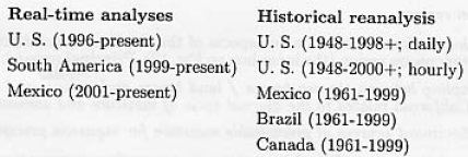
The overall goal of this effort is to couple real-time daily analyses with historical reanalyzes for all of the Americas, so that current anomalies can he placed in the proper historical context. Real-time daily analyses for the U. S. and South America are available at the URL:
http://www.cpc.ncep.noaa.gov/products/precip/realtime/
The daily precipitation reanalysis for the U. S. is based on a Unified Raingauge Data set (URD) (Higgins et al., 2000). The hourly precipitation reanalysis is documented in Higgins et al. (1996).
5.2 Satellite-derived rainfall estimates
The Global Precipitation Climatology Project (GPCP) produces a 1° × 1° daily analysis of global precipitation that is based solely on satellite-derived precipitation estimates, from sun synchronous microwave (SSM/I) data and geosynchronous infra-red (IR) data. Rainfall analyses on a 2.5° × 2.5° grid, in which rain gauge and satellite estimates are merged, are also available for 1979-present on monthly and pentad time scales. Although the spatial and temporal scales of these data sets are relatively coarse, their availability over a 20+ year period is useful for studies of interannual variability.
The Office of Research and Applications, NOAA/NESDIS has developed operational and experimental pixel scale resolution precipitation estimates. An IR technique (Vicente et al., 1998) is currently run operationally in real time for the continental U. S. with estimates made for other areas of the world as well. A host of precipitation-related products, some operational and some experimental, are presently available from NOAA/NESDlS.
The CPC Merged Analysis of Precipitation (CMAP) is a technique that was developed and implemented at CPC to produce monthly and pentad global precipitation analyses at 2.5° × 2.5° spatial resolution by blending rain gauge observations with various satellite estimates of precipitation using inverse error weighting for the 1979 to present period (Xie and Arhin, 1996; 1998).
At least two aspects of the satellite-based rainfall products are of utility to studies of the NAMS. First, they provide serially and temporally complete estimates of precipitation over the East Pacific, Gulf of California, and Intra-Americas Sea region. Secondly, the satellite estimates (perhaps even the IR data alone) can provide a means of quality control for raingnuge data. Simple comparisons of time and space co-locations of IR and raingnuge information can be used, for example, to discard non-zero raingauge reports when the satellite data suggest that clouds are absent.
6. Future challenges
Despite significant advances in our understanding of the NAMS and its variability, many challenges remain, The climate community has not been very successful in extending our knowledge of the monsoon to improved prediction of warm season precipitation. It is instructive to review sonic of the outstanding science questions associated with gaps in our understanding of the NAMS. Field studies that would target these gaps, and result in the improved understanding necessary to advance warm season precipitation prediction must be undertaken.
6.1 Core monsoon region
At the local scale, the focus should be an aspects of the low-level circulation and precipitation patterns in the core monsoon region (the inner box on Fig. 12). Principal research questions include:
(1) How is the coupling between the sea breeze / land breeze and mountain / valley circulations along the Gulf of California related to the diurnal cycle of moisture and convection
(2) What are the dominant sources of precipitable moisture for monsoon precipitation?
(3) What ale the relative roles of local variations in sea surface temperature and land-surface parameters (topography, soil moisture and vegetation cover) in modulating precipitation?
The large-scale coupling between the low-level circulations along the Gulf of California and along the western slopes of the Sierra Madre Occidental is intimately related to the diurnal cycle of moisture and convection (Fig. 11 shows a schematic representation). The amplitude of the diurnal cycle is regime dependent, so it is important to understand the nature of the relationship between the diurnal cycle and the seasonally varying atmospheric circulation and precipitation patterns. The core monsoon region is uniquely suited for studies of the role of the diurnal cycle because it is a region where the amplitude of the diurnal cycle far exceeds the amplitude of the annual cycle.
The diurnal cycle and related processes and feedbacks are poorly represented in models (both mesoscale and global)r This is true not only over the core monsoon region, but also at most locations over North America during the warm season (e.g., the southeastern U. S.). Although indirect estimates of many of the low-level circulation features are provided by satellite remote sensing techniques (e.g., cloud-track winds and the diurnal cycle of cloud cover), these analyses have deficiencies and require calibration. Better documentation of the horizontal and vertical structure of these circulation features and their relationships to convection is critical.
High resolution models and analyses ate required to examine the different atmospheric pathways for moisture onto the NAMS domain from the Gulf of Mexico and the Pacific/Gulf of California. Characterization of deep convection will play an important role in the vertical transport of moisture that facilitates long distance transport of water deep into the continent. Additional studies using high-resolution mesoscale models and analyses are needed to describe linkages between the sea breeze/land breeze phenomenon and the intense afternoon and evening precipitation along the west slopes of the Sierra Madre Occidental and the morning precipitation near the coastline and over the Gulf of California. Modeling studies of the diurnal cycle of convection are also required, particularly to determine the effects of model resolution and changes in physical parameterizations on precipitation in the core monsoon region.
Modeling studies with various combinations of the relevant boundary forcing parameters are required to determine the relative contributions of Gulf of California SSTs, soil moisture and vegetation to warm season precipitation variability in the core monsoon region. Studies withstand alone hydrological models, using observed and model-calculated forcing, are also required to investigate the influence of topography-dependent precipitation on the hydrological response of watersheds. Multi-member ensemble experiments with high-resolution regional coupled models are also needed for areas with marked topography to calculate topography-dependent precipitation probability distribution functions (PDFs) for validation against observed PDFs.
At present, we know relatively little about laud surface conditions and fluxes over most of the NAMS region (Arizona and New Mexico are the exception, although the data are still relatively sparse). Measurements of latent/sensible heat flux and net radiation at strategically located towers would provide the critical information needed to understand how the land surface state evolves throughout the monsoon season. The surface flux data would provide important ground truth for more spatially extensive satellite estimates. Much of the NAMS domain is characterized by a heterogeneous, highly variable terrain and vegetation. For example, there are many densely vegetated ribbons along rivers (1 km wide in some places) that may account for a substantial fraction of the evapotranspiration of the region. Characterizing the surface fluxes here is challenging, but critical, for understanding and simulating the hydrologic cycle in southwestern North America.
Improvements in satellite-based characterization of soils and vegetation and associated estimates of sensible and latent heat fluxes are needed in order to derive comprehensive estimates of land surface characteristics. Many operational satellite data products are limited in spatial resolution. New satellite instruments, such as ASTER on EOS-AM1, promise higher spatial resolution (order 10s of meters), which will be important for characterization of hydrological parameters in areas of sharp gradients, e.g.. river valleys and mountainous regions.
6.2 Regional-scale
On the regional scale (middle box of Fig. 12) emphasis must be placed on an improved description and understanding of intraseasonal aspects of the monsoon. Some questions involving key features and relationships at this scale include:
(1) What are the roles of the Great Plains low level jet (GPLLJ) and the Gulf of California low level jet (GCLLJ) in the summer precipitation and hydrology of lite region?
(2) What are the mechanisms, including atmospheric dynamic, thermodynamic, and land and ocean surface influences responsible for the GPLLJ and GCLLJ and their modulation on seasonal-to-interannual times scales?
(3) How important are interactions between tropical easterly waves, the LLJ's and moisture surges?
(4) What is the nature of the relationship between the MJO, tropical cyclone activity and monsoon precipitation?
(5) What is the role of the intertropical convergence zone/cold tongue complex and the warm pool region to the southwest of Mexico?
(6) What is the physical setting for the bimodal distribution (i.e., wet-dry-wet) in warm season precipitation over Mexico and Central America and what factors influence its interannual variability?
The GPLLJ plays a critical role in the summer precipitation and hydrology of the central U.S. while the GCLLJ contributes to the summer precipitation and hydrology in the southwestern U.S. and Mexico (Fig. 11), Developing a better understanding of both of these jets and their possible interactions is critical to a better understanding of the summer precipitation and hydrology within the NAMS domain.
The GPLLJ transports considerable moisture from the Gulf of Mexico and eastern Mexico into the central U.S. It is influenced by various factors including large-scale dynamics, the strength and size of the energy sources over the Gulf of Mexico and the Intra-Americas Sea, and land surface effects, including vertical motion induced by topography, elevated heat source and dynamic effects over the Rocky Mountains, radiation balances on the land, and temperature contrasts between the land and the Gulf of Mexico. The diabatic effects of land in this regional circulation must be understood and modeled. For example, nocturnal dynamic and thermodynamic factors may be mutually reinforcing, thus contributing to the strength of the moisture convergence into the Mississippi River Basin during the night and early morning.
The GCLLJ is inextricably linked to tropical easterly waves and Gulf of California moisture surge events that play a critical role in the intraseasonal variability of the monsoon along the west coast of Mexico and in the southwestern U.S. Most of the moisture in the lower troposphere (below 850-hPa) over the southwestern U.S. (west of the continental divide) arrives with the GCLLJ, while most of the moisture at higher levels arrives from over the Gulf of Mexico, Difficulties in explaining the observed precipitation distribution and its timing have been due, in part, to the fact that Baja California and the Gulf of California have not been properly resolved in models and reanalyzes in the post.
Observational and modeling studies of tropical easterly waves, moisture surges and their interactions are needed, for these disturbances appear to have a significant influence on monsoon rainfall over a season. Diagnostic studies are needed to examine the structure of the tropical easterly waves and gulf surge events, their frequency of occurrence, and the temporal evolution of the associated moisture transport. An important goal is to gather sufficient data to determine whether gulf surges enhance rainfall lb the mean, or simply adjust the rainfall distribution. In order to be useful, models must reproduce the common weather characteristics of these disturbances (e.g., in the case of the moisture surges, a rise in dewpoint temperature, a decrease in diurnal temperature range, an increased southerly wind component, and increased cloudiness and precipitation) which ran be validated against in situ and satellite remote sensing data.
The intraseasonal variability of monsoon precipitation over the region is also related to the eastward progression of intraseasonal oscillations (such as the MJO) around the global tropics. Of tremendous practical significance is the fact that there is a coherent relationship between the phase of the MJO and the points of origin of tropical cyclones in the western Pacific, eastern Pacific and Atlantic basins, suggesting that the MJO modulates this activity. Additional studies are needed to determine how the phase of the MJO relates to the frequency and intensity of hurricanes and tropical storms, what fraction of the summer rainfall over the Americas is due to tropical storms and hurricanes and whether interannual-to-interdecadal variability of the MJO contributes to tropical cyclone frequency and intensity. Recent studies by Slingo et al., (1995) and others have performed detailed comparisons of the ability of GCMs to simulate the MJO. The large differences between GCMs found in these studies highlight the difficulty we face in obtaining realistic simulations of tropical low-frequency variability.
While ENSO-related impacts on the NAMS are reasonably well documented, MJO-related impacts on the NAMS and the relative influences of the MJO and ENSO are not well understood. Thus, it is also important to determine the relationships between the MJO, ENSO, and monsoon precipitation. This includes investigations of the regional dependence of ENSO-related and MJO-related impacts on summer rainfall, in particular to determine under what circumstances these impacts arc in the same (opposite) sense. Statistical relationships between these phenomena and weather extremes (e.g., floods, droughts, heat waves) should be examined to obtain detailed information on their climatic signatures. This includes studies of the role of Pacific tropical storms, which can contribute a major fraction of annual rainfall to inland areas of Mexico and the southwestern U.S. (in a manner analogous to the Bengal and Arabian cyclones in the Indian monsoon).
Diagnostic and modeling studies are required to investigate the role of the ITCZ/cold-tongue complex and the warm pool off the west coast of southern Mexico and Central America in warm season precipitation variability over the monsoon region. Of particular interest is the evolution of the midsummer drought and the pronounced double peak structure in summer precipitation over Mexico and Central America (Fig. 4). New in situ and satellite data sets from the Eastern Pacific Investigation of Climate (EPIC) Project will provide an opportunity to understand and improve the simulation of relationships between SST, surface wind stress, precipitation and cloudiness over the eastern Pacific region.
6.3 Continental-scale monsoon
At the continental scale (outer box on Fig. 12), the focus should be on an improved description and understanding of the spatial and temporal linkages between warm season precipitation, circulation patterns, and the dominant boundary forcing parameters (both lend and ocean). Some key scientific questions are:
(1) How is the evolution of warm season precipitation over North America related to the seasonal evolution of the surface boundary conditions?
(2) What are the relationships between interannual variations in these boundary conditions, the atmospheric circulation and the continental hydrologic regime?
(3) What is the correlation between the anomaly sustaining atmospheric circulation and the land and ocean surface boundary conditions that characterize precipitation and temperature anomalies during the summer?
(4) What are the dynamical links between the strength of the summer monsoon in southwestern North America and summertime precipitation over the central U. S.?
(5) What are the relationships between the statistical frequency and magnitude of extreme events (e.g., floods, droughts, hurricanes) and climate variability on intraseasonal-to-interannual time scales?
The land and ocean surface memory components of the climate system evolve more slowly than the individual precipitation-producing circulation systems and are to some degree predictable in their own right. Prospects for improved seasonnl-to-interannual prediction hinge on the inherent predictability of the system, and our ability to quantify the initial states and forecast the evolution of the surface forcing variables (i.e., SST, vegetation and soil moisture).
Empirical and modeling studies that enhance our dynamical understanding of the seasonal march of the monsoon and its variability are critical. An important prerequisite is to gather sufficient data to accurately describe the life cycle of the monsoon. Additional analyses of existing in situ data and satellite remote sensing data sets are required to investigate statistical relationships with boundary forcing parameters and to examine the interannual variability of such relationships.
This includes studies that elucidate how the relative importance of the land and ocean influences on North American precipitation change with the seasons. Statistical studies are also needed to search for predictability between observed boundary forcing anomalies and subsequent circulation and precipitation anomalies.
The influence of tropical SST anomalies on North American climate is statistically most obvious during the cold season, but warm season correlations between SST and continental-scale precipitation are at least marginal. The climate system exhibits some simplicity in the form of a few phenomena that arc the building blocks to progress in climate forecasting. The El Niño/ Southern Oscillation (ENSO) phenomenon is the major source and best understood of these. Climate research has identified several additional oceanic and atmospheric phenomena that establish global climate patterns, including the Pacific Decadal Oscillation (PDO), and the MJO. The PDO, like ENSO. can cause systematic changes in the large-scale circulation patterns that lead to regional changes in the number and intensity of storms. The MJO, when it is active, dramatically increases the intraseasonal variability in the tropics and subtropics. The relative influences of these modes of variability, or others not yet identified, on the warm season precipitation regime over North America are not well understood.
The relative importance of the land and ocean influences on North American precipitation and surface evapotranspiration is large and varies greatly with the seasons. The influence of the land surface is strongest during the warm season, when the continents are warmer than the surrounding oceans and surface evaporation is large and varies greatly as a function of terrain and vegetative cover. It should be noted that the influence of SST anomalies on cold season precipitation can indirectly affect warm season rainfall, since they play a role in determining the initial springtime soil moisture conditions and vegetative cover, which in turn can feed back upon the climate during the warm months through their influence on surface air temperature and evapotranspiration.
There is persuasive evidence that potentially predictable anomalies of soil moisture, snow cover and vegetation may play an important role in the seasonal variability of North American warm season precipitation patterns. Because these land surface anomalies are themselves largely determined by fluctuations of precipitation, it has been suggested that there are important feedbacks between the atmosphere and land surface that can be either positive (in which case climate anomalies are self-sustaining) or negative (self-suppressing). Diagnosis of these feedback pathways will require significant advances in the quality of observations and modeling of the lVAMS domain.
The complex terrain and semi-arid conditions of southwestern North America stand in stark contrast to the Mississippi Valley, which was the focus of the GEWEX Continental-scale International Project (GCIP). For example, in the southwest lush natural vegetation exists primarily in narrow strips along the banks of rivers in the middle of arid deserts. A proper characterization of large-scale evapotranspiration must somehow resolve these one-dimensional ribbons of vegetation, which can he much narrower than the typical footprint of an AVHRR-based vegetation scene.
Soil moisture also varies much differently in the arid NAMS domain compared with the more mesic GCIP region. Soil type and vegetation cover depend strongly on the surface elevation and slope aspect, both of which are tremendously variable over short distances in regions of complex terrain. Runoff is highly channelized. The short duration of most warm season precipitation episodes, combined with intense solar radiation, make for intense but short-lived episodes of surface evaporation following rainstorms.
Coupled ocean-atmosphere-land modeling and predictability studies are needed to determine the extent to which links between the summer monsoon in southwestern North America and summertime precipitation in the Great Plains of the U. S. have predictive value at the seasonal time scale. This includes studies of links between the strength of the summer monsoon and major flood (drought) episodes over the central U. S. A. critical aspect of this problem is the extent to which energy sources over the Gulf of Mexico / Intra-Americas Sea are related to the Great Plains low-level jet and its variability. Numerical experiments using coupled models with specified observed boundary conditions (e.g., observed SSTs over the Gulf of Mexico / Intra-Americas Sea; soil moisture over the Great Plains) are required to investigate whether models can reproduce statistically significant predictive relationships. Multi-member ensemble integrations with high-resolution coupled models, with and without interactive boundary forcing, are needed to determine the relative sensitivity of the models to changes in SST -vs- land memory processes.
The American Southwest is characterized by complex terrain and correspondingly sharp gradients in vegetation, and warm season precipitation in this region results principally from deep convective thunderstorms. These features of the warm season precipitation regime motivate the need for improved high-resolution modeling. For assessments of predictability it will be important to ascertain the extent to which the large-scale anomalies that are the customary focus of seasonal predictive efforts are expressed on the smaller scales of importance for land surface hydrology. Skillful downscaling of climate anomalies will be a necessary component of useful seasonal forecasts in this region.
It is increasingly clear that a better understanding of the linkages between weather and climate is needed since many decision making processes are directly tied to weather "events". It is the yet largely unexplained relationships between extreme weather events, climate variability, and long-term trends that are likely to have the most direct impacts on society. A better understanding of these relationships will only come from additional diagnostic studies and numerical experimentation that determine how the leading patterns of climate variability regulate the numbers of dailv weather extremes, how changes in daily weather extremes are related to tang-term trends, and how climate variability is related to long-term, trends. Such studies will help to focus attention on the physical phenomena that climate variability and climate change models must be able to simulate in order to be deemed credible for use in weather and climate forecasts and assessments.
Prediction of the detailed distribution of continental precipitation is a challenging task since it requires the skillful modeling of the subtle interplay between land surface and oceanic influences such as the complicating influences of terrain and coastal geometry. While resolution of global models continues to increase with enhancements in computational capability, there is also a need for higher resolution mesoscale models and multi-year assimilated data sets to address the issues above. Previous efforts of CLIVAR (e.g., PACS) and GEWEX (e.g., GCIP) provide a strong foundation for these studies and offer tremendous opportunities for coordination and collaboration. Sufficient observational data arc needed to clearly distinguish between the models. This is a primary motivation for the North American Monsoon Experiment (NAME) field campaign (section 6.4).
6.4 The North American Monsoon Experiment (NAME)
State-of-the-art climate models do not accurately represent the spatial distribution and temporal variability of warm season precipitation over North America, There are many processes and feedbacks operating within the atmosphere, at the surface, and below the surface that are not represented in the models. These deficiencies are the motivation for the North American Monsoon Experiment (NAME), an internationally coordinated, joint CLIVAR-GEWEX process study aimed at determining the sources and limits of predictability of warm season precipitation over North America, with emphasis on time scales ranging from seasonal-to-interanmial. It focuses on observing and understanding the key components of the North American monsoon system and their variability within the context of the evolving land surface- atmosphere-ocean annual cycle. It seeks improved understanding of the key physical processes that must be parameterized for improved simulation with dynamical models. NAME employs a multi-scale (tiered) approach with focused monitoring, diagnostic and modeling activities in the core monsoon region, on the regional-scale and on the continental-scale (Fig. 12).
The scientific objectives of NAME are to promote a better understanding and more realistic simulation of:
(1) The evolution of the North American monsoon system and its variability;
(2) The response of the warm season atmospheric circulation and precipitation patterns over North America to slowly varying, potentially predictable surface boundary conditions (e.g., SST, soil moisture and vegetation);
(3) Warm season convective processes in complex coastal terrain;
(4) The: diurnal heating cycle and its relationship to the seasonally varying mean climate;
(5) Intraseosonal variability of the monsoon.
In addition to these scientific objectives, NAME researchers will interact with applications, assessment, and human dimensions researchers on the potential use of NAME science by end-users.
To achieve these objectives, planning has proceeded with the intent of developing:
(1) Empirical and modeling studies plus data set development and enhanced monitoring activities that carry on some elements of the existing PACS program and the PACS/GAPP Warm Season Precipitation Initiative (2000 onward), initiate new elements, and provide the spatial and temporal context for NAME;
(2) Field activities in the core region of the North American monsoon, during the summer of 2004, including build-up, field, analysis and modeling phases (2003-2008);
(3) Strong links between the VAMOS element of CLIVAR, U.S. CLIVAR Pan American research, and the GEWEX America Prediction Project (GAPP).
In addition to significant improvements in short-term climate prediction NAME will lead to joint international experience with Mexican and Central American scientists in the exploitation of in situ and satellite data, advancements in high-resolution climate models, advancements in the development of the climate observing system, and the production of consistent climate data sets over the Americas.
NAME is part of the CLIVAR/VAMOS program, U S. CLIVAR Pan American research, and the GEWEX Americas Prediction Project (GAFP). As such it will enjoy synergy with many other programs, ongoing and planned, including MESA, SALLJEX, EPIC, GAPP, and CEOP. NAME objectives are closely linked with those of the PACS/GGAPP Warm Season Precipitation Initiative, in particular through mutual interest on understanding the mechanisms associated with warm season rainfall and its potential predictability, NAME will also contribute to the goals of the U.S. Global Water Cycle Initiative, by addressing questions specific to that initiative, namely "What are the underlying causes of variations in the water cycle on both global and regional scales?" and "To what extent are variations in the global and regional water cycles predictable?".
All NAME activities, including complete documental ion on the project, are available on the NAME Homepage: http://www.joss.ucar.edu/name
Acknowledgements
We are very grateful to the organizers of the 2000 US CLIVAR Pan American PI Meeting in Potomac, MD, and particularly to Steve Esbensen of Oregon State University and Roberto Mechoso of the University of California at Los Angeles for initiating and shepherding this work. The authors also wish to thank Mathew Barlow for providing the data set used to prepare Figures 9. James Hack and Mark Stevens kindly prepared Figure 10.
References
Adams, D. K. and A. C Comrie, 1997: The North American monsoon. Bull. Amer. Meteor. Soc. 78, 2197-2213. [ Links ]
Amador, J. A., V. O. Magaa, and J. B. Perez, 2000. The Low Level Jet and Convective Activity in the Caribbean. IN: Proceedings of 24th AMS Conf. on Hurricanes and Tropical Meteorology. 114-115. 29 May to 2 June 2000. [ Links ]
Arritt, R. W., D. C. Goering, and C. J. Anderson. R. W., 2000: The North American monsoon system in the Hadley Centre coupled ocean-atmosphere GCM. Geophys. Res. Letters. 27, 565-568. [ Links ]
Augustine, J. A. and F. Caracena, 1996: Lower-tropospheric precursors to nocturnal MCS development over the central United States. Wea. and For., 9, 116-135. [ Links ]
Avissar, R. and R.A. Pielke, 1989. A parameterization of heterogeneous land-surface for atmospheric numerical models and its impact on regional meteorology. Man. Wea. Rev., 117, 2113-2136. [ Links ]
Baden-Dagan, A., C E. Dorman, M. A. Merrifield, and C D. Winant. 1991: The lower atmosphere over the Gulf of California. J. Geophys. Res., 96, 16877-16896. [ Links ]
Barlow, M., S. Nigam and E. H. Berbery, 1998: Evolution of the North American Monsoon System. J. Climate. 11, 2238-2257. [ Links ]
Barnett, T. P., L. Dumenil, U. Schlese, E. Roeckner and M. Latif, 1989: The effect of Eurasian snow cover on regional and global climate variations. J. Atmos. Sci, 46, 661-685. [ Links ]
Berbery, E. H., 2001: Mesoscale moisture analysis of the North American monsoon. J. Climate, 14, 121-137. [ Links ]
Bonner, W. D., 1968: Climatology of the low-level jet. Men. Wea. Rev., 96, 833-850. [ Links ]
Bonner, W. D., and J. Paegle, 1970: Diurnal variations in the boundary layer winds over the south-central United States in summer, Mon. Wea. Rev., 98, 735-744. [ Links ]
Boyle, J. S., 1998: Evaluation of the annual cycle of precipitation over the United States in GCMs:AMIP simulations. J. Climate, 11, 1041-1055. [ Links ]
Brenner, I. S., 1974: A surge of maritime tropical air-Gulf of California to the southwestern United States. Mori. Wea. Rev., 102, 375-389. [ Links ]
Bryson, R. A., and W. P. Lowry, 1955: The synoptic climatology of the Arizona summer precipitation singularity. Bull. Amer. Meteor. Soc, 36, 329-339. [ Links ]
Carleton, A. M., 1986: Synoptic-dynamic character of "bursts" and "breaks" in the southwest U.S. summer precipitation singularity. J. Climatol, 6, 605-623. [ Links ]
Carleton, A. M., 1987: Summer circulation climate of the American Southwest, 1945-1984. Ann. Assoc. Amer. Geogr., 77, 619-634. [ Links ]
Carleton, A. M., D, A., Carpenter, and P. J. Weser, 1990: Mechanisms of interannual variability of the Southwest United States summer rainfall maximum. J. Climate, 3, 999-1015. [ Links ]
Castro, C. L., T. B. McKee, and R.A. Pielke Sr., 2000a: The climatology and interannual variability of the North American monsoon as revealed by the NCEP/NCAR Reanalysis. Preprints, 11th Symposium on Global Change Studios, 80th AMS Annual Meeting, Long Beach, CA, January 9-14, 2000, 108-171. [ Links ]
Castro, C.L., T.B. McKee, and R A. Pielke, Sr. 2000b: The Relationship of the North American Monsoon to Tropical and North Pacific Sea Surface Tempertures as Revealed by Observational Analyses. J. Climate, submitted.
Dhar, O. N., P. R. Rakhecha, and B. N. Mandal, 1980: Docs the early or late onset of the monsoon provide any clue to the subsequent rainfall during the monsoon season? Mon. Wea. Rev., 108, 1069-1072. [ Links ]
Douglas, M. W., R. A. Maddox, K. Howard and S. Reyes. 1993: The Mexican Monsoon. J. Climate, 6, 1665-1677. [ Links ]
Douglas, M. W., 1993: Current research into the monsoon. Sonorensis, Arizona Sonora Desert Museum Newsletter, 13, Nums. 3, 10-11 [Available from the Arizona Sonora Desert Museum, 2021 N. Kinney Rd., Tucson, AZ, 85743] [ Links ]
Douglas, M. W., 1995: The summertime low-level jet over the Gulf of California, Mon. Wea. Rev., 123, 2334-2347. [ Links ]
Douglas, M. W., A. Valdez-Manzanilla, and R. Garca Cueto, 1993: Diurnal variations and horizontal extent of the low-level jet over the northern Gulf of California. Mon. Wea. Rev.. 126, 2017-2025. [ Links ]
Douglas, A.V., D. Cayan and J. Namias, 1952: Large scale changes in North Pacific and North American weather patterns in recent decades. Mon. Wea. Rev., 110, 1851-1862. [ Links ]
Douglas, A.V., R. Blackmon, and P.J. Englehart, 1986: Mesoscale convective complexes in extreme Western Mexico: A regional response to broadscale drought. Proc. Tenth Ann. Climate Diagnostics Workshop, U.S. Department of Commerce, NOAA, 129-140. [ Links ]
Douglas, A. V., 1988: Factors influencing summer temperatures and precipitation in the Southwest. Proc. Twetth Ann. Climate Diagnostics Workshop, U.S. Dept. of Commerce, NOAA, 266-275. [ Links ]
Douglas, A.V., and P.J. Englehart, 1996; An analysis of the starting date for the summer monsoon in Western Mexico and Southeast Arizona. Proc. Twentieth Ann. Climate Diagnostics Workshop, U.S. Department of Commerce, NOAA 207-211. [ Links ]
Douglas, A.V., and P.J. Englehart, 1998: Diagnostic Study of the Mexican Drought of 1997-98. Proc. Twenty-second Ann. Climate Diagnostics and Prediction Workshop, U.S. Department of Commerce, NOAA, 26-29. [ Links ]
Eastman, J.L., M.B. Coughenour, and R.A. Pielke, 2000: The effects of CO2 and landscape change using a coupled plant and meteorological model. Global Change Biology, submitted.
Enfield, D. A.M. Marias-Nunez and P.J. Trimble , 2001: The Atlantic multidecadal oscillation and ita relationship and rainfall and river flows in the continental U.S. Geophys. Res. Lett. (submitted)
Englehart, P.J. and A.V. Douglas, 2001: Eastern North Pacific Tropical Storms and the Rainfall Climatology of Western Mexico. International Journal of Climatology, Final revised copy accepted for publication Dee. 6, 2000, 26 pp., 8 figures.
Englehart, P.J. , and A.V. Douglas, 1985: A statistical analysis of precipitation frequency in the conterminous United States, including comparisons with precipitation totals. JCAM, 24, 350-362. [ Links ]
Fox-Rabinovitz, M. S., L.V., Stenchikov, M.J. Suarez, L.L. Takacs, 1997: A finite-difference GCM dynamical care with a variable resolution stretched-grid, Mon. Wea. Rev., 125, 2943-2968. [ Links ]
Fox-Rabinovitz, M. S., L.L. Takacs, R.C. Govindaraju, and M.J. Suarez, 2001a; A Variable Resolution Stretched Grid GCM; Regional Climate Simulation, Mon. Wea. Rev., in press.
Fox-Rabinovitz, M. S., 2001b: Regional climate simulation of the anomalous U.S. summer events using a variable-resolution stretched-grid GCM. J. Geophys. Res, in press.
Fritsch, J.M., and R.A. Maddox, 1981: Convectively-driven mesoscale pressure systems aloft. Part I: Observations. J. Appl. Meteor., 20, 9-19. [ Links ]
Fuller, R. D. and D. J. Stensrud, 2000: The relationship between easterly waves and surges over the Gulf of California during the North American monsoon. Man. Wea. Rev., in press.
Gates, W. L., 1992: The Atmospheric Model inter comparison Project. Bull. Amer, Meteor. Set. 73, 1962-1970. [ Links ]
Gochis, D., W. J. Shuttlewortb, R.A. Maddox and Z.-L. Yang, 2000: Quantification of error in a pseudo regional climate simulation of the North American Monsoon, Southwest Weather Symposium, Tucson, Arizona, September 2000, x.l-x.5. [ Links ]
Gochis, D., W.J. Shuttleworth and Z.-L. Yang, 2001: Sensitivity of the modelled North American Monsoon regional climate to convective parameterization. Mon. Wea. Rev., submitted.
Graham, N. E., T. P. Barnett, R. Wilde, M. Ponater, and S. Schubert, 1994: On the role of tropical and midlatitude SSTs in forcing interannual to interdecadal variability in the winter Northern Hemisphere circulation. J. Climate, 7, 1416-1441. [ Links ]
Grell, G. A. 1993: Prognostic evaluation of assumptions used by cumulus parameterizations. Mon. Wea. Rev., 121, 764-787. [ Links ]
Grell, G. A., J. Dudhia, and D.R. Stauffer, 1994: A description of the fifth generation Penn State/NCAR mesoscale model (MM5). NCAR Tech. Note NCAR/TN-380+STR, 138 pp. [ Links ]
Gutzler, D. S., 2000: Covariability of spring snowpack and summer rainfall across the Southwest United States. J. Climate, 13, 4018-4027. [ Links ]
Gutzler, D. S., and J. W. Preston, 1997: Evidence for a relationship between spring snow cover in North America and summer rainfall in New Mexico. Geophys. Res. Letters, 24, 2207-2210. [ Links ]
Hahmarm, A. N., and R. E. Dickinson, 2001: A line-mesh land approach for general circulation models and its Impact on regional climate. J. Climate, in Press.
E.Hales, J. , Jr., 1972: Surges of maritime tropical air northward over the Gulf of California, Mon. Wea. Rev., 100, 293-306. [ Links ]
E.Hales, J. , Jr., 1974: Southwestern United States summer monsoon source-Gulf of Mexico or Pacific Ocean? J. Appl. Meteor., 13, 331-342. [ Links ]
Hardiker, V., 1997: A global numerical weather prediction model with variable resolution. Mon. Wea. Rev., 125, 349-360. [ Links ]
Harman, J. R., 1991: Synoptic Climatology of the Westerlies: Process and Patterns. Association of American Geographers, 80 pp. [ Links ]
Harrington, J. A., Jr., R. S. Cerveny, and R. Balling, Jr,, 1992: Impact of the Southern Oscillation on the North American Southwest monsoon. Physical Geography, 13(4), 318-330. [ Links ]
Helfand, H. M. and S. D. Schubert. 1995: Climatology of the Great Plains low-level jet and its contribution to the continental moisture budget of the United States. J. Climate. 8, 784-806. [ Links ]
Hereford, R. and R. Webb, 1992: Historical variations of warm-season rainfall, southern Colorado Plateau, southwestern U.S.A. Climate Change, 22, 239-256. [ Links ]
Higgins, R. W., J. E. Janowiak and Y. Yao, 1996: A gridded hourly precipitation data base for the United States (1903-1993). NCEP/Climate Prediction Center ATLAS No. 1, 47 pp. [ Links ]
Higgins, R. W., R. W., Y. Yao, E. S. Yarosh, J. E. Janowiak and K. C. Mo, 1997a: Influence of the Great Plains low-level jet on summertime precipitation and moisture transport over the central United States. J. Climate., 10, 461-507. [ Links ]
Higgins, R. W., R. W., Y. Yao, and X. Wang, 1997b: Influence of the North American Monsoon System on the United States summer precipitation regime. J. Climate, 10, 2600-2622. [ Links ]
Higgins, R. W., K. C. Mo and Y. Yao, 1998: lnteranuuaf variability of the United States summer precipitation regime with emphasis on the southwestern monsoon. J. Climate, 11, 2582-2606. [ Links ]
Higgins, R. W., Y. Chen and A. Douglas, 1999: Interannual variability of the North American warm season precipitation regime, J. Climate, 12, 653-680. [ Links ]
Higgins, R. W., and W. Shi, 2000: Dominant factors responsible for interannual variability of the Summer monsoon in the southwestern United States. J. Climate, 13, 759-776. [ Links ]
Higgins, R. W., W. Shi and E. Yarosh, 2000: Improved United States Precipitation Quality Control System and Analysis. NCEP/Climate Prediction Center ATLAS No. 7, 40 pp. [ Links ]
Higgins, R. W., and W. Whi, 2001: Intercomparison of the Principal Modes of Interannual and Intraseasonal Variability of the North American Monsoon System. J. Climate, 14, 403-417. [ Links ]
Huang, Z., and C. A. Lai, 1998: Multidecadal variability on the southwestern United States monsoon precipitation in the past century. Proceedings of the 9th Conference on the Interaction of the Sea and Atmosphere, pp. 159-166 [Available from American Meteorological Society, Boston, MA,02108-3693] [ Links ]
Janjic, Z.I., 1994: The step-mountain eta coordinate model: Further developments of the convection, viscous sublayer, and turbulence closure schemes. Mon. Wea. Rev., 122, 927-945. [ Links ]
Johnson, A. M., 1976: The climate of Peru, Bolivia and Ecuador. Climates of Central and South America, World Survey of Climatology, Vol. 12, W. Schwerdtfeger and H. E. Landsberg, Eds., Elsevier, 147-218. [ Links ]
Kalnay, E., and co-authors, 1996: The NCEP/NCAR Reanalysis Project. Bull. Amer. Meteor. Soc., 77, 437-471. [ Links ]
Kain, J.S. and M. Fritsch, 1990: A one-dimensional entraining/detraining plume model and its application in convective parameterization, J. Atmo. Sci., 47 (23), 2784-2802. [ Links ]
Kayano, M. T., and V. E. Kousky, 1999: Intraseasonal (30-60 day) variability in the global tropics: principal modes and their evolution. Tellus, 51A, 373-386. [ Links ]
Keyser, D.A., and D.R. Johnson, 1984: Effects of diabatic heating on the ageostrophic circulation of an upper tropospheric jet streak, Mon. Wea. Rev., 112, 1709-1724. [ Links ]
Kiladis, G. N., and H. Van Loon, 1938: The Southern Oscillation. Part VII: Meteorological anomalies over the Indian and Pacific sectors associated with extremes of the oscillation. Mon. Wea. Rev., 116, 120-136. [ Links ]
Koster, R. D., and M. J. Suarez, 1992: Modeling the land surface boundary in climate models as a composite of independent vegetation stands. J. Geophys. Res., 97, 2697-2715. [ Links ]
Latif, M., and T. P. Barnett, 1994: Causes of decadal climate variability over the North Pacific / North American sector. Science. 266, 634-637. [ Links ]
Latif, M., and T. P Barnett, 1996: Decadal climate variability over the North Pacific and North America: Dynamics and predictability. J. Climate, 0, 2407-2423. [ Links ]
Legates, D. R., and C. J. Willmott, 1990: Mean seasonal and spatial variability in gauge- corrected, global precipitation. Int. J. Climatol., 10. 111-127. [ Links ]
Liebmann, B., H. Hendon and J. Glick, 1994: The relationship between tropical cyclones of the western Pacific and Indian Oceans and the Madden-Julian Oscillation. J. Met. Soc. Japan, 72, 401-411. [ Links ]
Lu, L., R.A. Pielke, G.E. Liston, W.J. Parton, D. Ojima, and M. Hartman, 2000: Implementation of a two-way interactive atmospheric and ecological model and its application to the central United States. J. Climate, accepted with revisions.
Madden, R. A., and P. R. Julian, 1971: Detection of a 40-50 day oscillation in the zonal wind in the tropical Pacific. J. Atmos. Sci, 28, 702-708. [ Links ]
Madden, R. A., and P. R. Julian, 1972: Description of global-scale circulation cells in the tropics with a 40-50 day period. J. Atmos. Sci., 29, 1109-1123. [ Links ]
Madden, R. A., and P. R. Julian, 1994: Observations of the 40-50 day tropical oscillation -A review. Mon. Wea. Rev., 122, 814-837. [ Links ]
Maddox. R.A., 1980: Mesoscale convective complexes. Bull. Amer. Meteor. Soc., 61, 1374-1387. [ Links ]
Magaña, V., J. A. Amador, and S. Medina 1999: The Midsummer Drought over Mexico and Central America. J. Climate, 12, 1577-1588. [ Links ]
Maloney, E. D. and D. L. Hartmann, 2000a: The Madden-Julian Oscillation, barotropic dynamics, and North Pacific tropical cyclone formation. Part I: Observations. (Submitted to J. Atmos Sci.).
Maloney, E. D. and D. L. Hartrnann, 2000b: The Madden-Julian Oscillation, barotropic dynamics, and North Pacific tropical cyclone formation. Part II: Stochastic barotropic modeling (Submitted to J. Atmos Sci.)
McGregor, J. L., and J. J. Katzfey, 1998: Simulating typhoon recurvature with a variable resolution conformal-cubic model. In Research Activities in Atmospheric and Oceanic Modeling, Report No.28 (ed. H. Ritchie), WMO/TD-No.942, 3.19-3-20. [ Links ]
Mesinger, 1998: Comparison of quantitative precipitation forecasts by the 48- and by the 29-km Eta model: An update and possible implications. Preprints, 12th Conference on Numerical Weather Prediction, Phoenix, AZ, Amer. Meteor. Soc., J22-23. [ Links ]
Miller, A. J., D. R Cayan, T. P. Barnett, N. E. Graham, and J. M. Oberhuber. 1994: Interdecadal variability of the Pacific Ocean; Model response to observed heat flux and wind stress anomalies. Climate Dyn., 9, 287-302. [ Links ]
Mitchell, M. J., R. A. Arritt, and K. Labas, 1995: A climatology of the warm season Great Plains low-level jet using wind profiler observations. Wea. and For., 10, 576-591. [ Links ]
Mo, K. C, and J. N. Paegle, 2000: Influence of sea surface temperature anomalies on the precipitation regimes over the Southwest United States. J. Climate, 13, 3588-3598. [ Links ]
Mock, C. J. 1996: Climatic controls and spatial variations of precipitation in the western United States. J. Climate, 9, 1111-1125. [ Links ]
Namias, J., 1959: Recent seasonal interactions between North Pacific waters and the overlying atmospheric circulation. J. Geophys. Res., 64, 631-646. [ Links ]
Namias, J., X. Yuan, and D. R. Cayan, 1988: Persistence of North Pacific sea surface temperature and atmospheric flow patterns. J. Climate, 1, 682-703. [ Links ]
Ninomiya, K., 1971a: Dynamical analysis of outflow from tornado-producing thunderstorms as revealed by ATS III pictures. J. Appl. Meteor., 10, 275-294. [ Links ]
Ninomiya, K., 1971b: Mesoscale modification of synoptic situations from thunderstorm development as revealed by ATS III and aerological data. J. Appl Meteor., 10, 1103-1121. [ Links ]
Okabe, I. T., 1995: The North American Monsoon. PhD. Dissertation, Department of Geography, University of British Columbia, 146 pp. [ Links ]
Paegle, J., 1989; A variable resolution global model based upon Fourier and finite element representation. Mon. Wea. Rev., 117, 583-606. [ Links ]
Parker, S. S., J. T. Hawes, S. J. Colucci and B. P. Hayden, 1989: Climatology of 500 mb cyclones and anticyclones, 1950-1985. Mon. Wea. Rev., 117, 558-570. [ Links ]
Perkey, D.J., and R.A. Maddox, 1985: A numerical investigation of a mesoscale convective system. Mon. Wea. Rev., 113, 553-566. [ Links ]
Pielke, R.A., G.E. Liston, J.L. Eastman, L. Lu, and M. Coughenour, 1999: Seasonal weather prediction as an initial value problem. J. Geophys. Res., 104, 19403-19479. [ Links ]
Ramage, C. S., 1971: Monsoon Meteorology. Academic Press, 391 pp. [ Links ]
Rasmusson, E. M., 1966: Atmospheric water vapor transport and the hydrology of North America. Report No. A-1, Planetary Circulations Project, Massachusetts Institute of Technology, 170 pp. [ Links ]
Rasmusson, E. M., 1967: Atmospheric water vapor transport and the water balance of North America: Part 1. Characteristics of the water vapor flux field. Mon. Wea. Rev., 95, 403-426. [ Links ]
Rasmusson, E. M., 1968: Atmospheric water vapor transport and the water balance of North America; Part II. Large-scale water balance investigations. Mon. Wea. Rev., 96, 720-734. [ Links ]
Rowson, D. R., and S. J. Colucci, 1992: Synoptic climatology of thermal low-pressure systems over South-Western North America. J. Climatol., 12, 529-545. [ Links ]
Schmitz, J. T., and S. Mullen, 1996: Water vapor transport associated with the summertime North American Monsoon as depicted by ECMWF analyses. J. Climate, 9, 1621-1634. [ Links ]
Sellers, W. D., and R. H. Hill, 1974: Arizona Climate, 1931-1972. The University of Arizona Press, 616 pp. [ Links ]
Seth, A., F. Giorgi, and R. E. Dickinson, 1994: Simulating fluxes from heterogeneous land surfaces: Explicit subgrid method employing the Biosphere-Atmosphere Transfer Scheme (BATS). J. Geophys Res., 99, 18,651-18,667. [ Links ]
Slingo, J., and Coauthors, 1995: Intraseasonal oscillations in 15 atmospheric general circulation models: Results from an AMIP diagnostic subproject. World Climate Research Program Tech. Memo. 88, 28 pp. [Available from the WMO, Case Postale No, 2300, 1211, Geneva, Switzerland] [ Links ].
Small, E. E., 2001: The influence of soil moisture anomalies on variability of the North American monsoon system. Geophys. Res. Letters, 28, 139-142. [ Links ]
Stensrud, D. J., R. L. Gall, S. L. Mullen and K. W. Howard, 1995: Model Climatology of the Mexican Monsoon, J. Climate, 8, 1775-1794. [ Links ]
Stensrud, D. J., 1996: Effects of a persistent, midlatitude mesoscale region of convection on the large-scale environment during the warm season. J. Atmos. Sci., 53, 3503-3527. [ Links ]
Stensrud, D. J., R. L. Gall, and M. K. Nordquist, 1997: Surges over the Gulf of California during the Mexican Monsoon. Mon. Wea. Rev., 125, 417-437. [ Links ]
Swanson, R. T., Jr., 1998: Regional-scale model climatology of the North American monsoon system. Doctoral Thesis, The University of Utah, 159 pp. [ Links ]
Tang, M. And E. R. Reiter, 1984: Plateau monsoons of the Northern Hemisphere: A comparison between North America and Tibet. Mon. Wea. Rev., 112, 617-637. [ Links ]
Ting, M. and H. Wang, 1997: Summertime U.S. precipitation variability and its relation to Pacific sea surface temperature. J. Climate, 10, 1853-1873. [ Links ]
Trenberth, K.E., and J. W. Hurrell, 1994: Decadal atmosphere-ocean variations in the Pacific. Climate Dyn., 9, 303-319. [ Links ]
Trenberth, K.E., and J. G. Olson, 1988; Evaluation of the NMC Global Analyses; 1979-1987. NCAR Technical Note / TN-299+STR, 82 pp. [ Links ]
Vernekar, A. D., J. Zhou, and J. Shukla, 1995: The effect of Eurasian snow cover on the Indian monsoon. J. Climate, 8, 248-266. [ Links ]
Vicente, G. A, R. A. Scofield, and W. P. Menzel, 1998: The operational GOES infrared rainfall estimation technique. Bull. Amer. Meteor. Soc, 79, 1983 - 1998. [ Links ]
Wallace, J. M., 1975: Diurnal variations in precipitation and thunderstorm frequency over the conterminous United States, Mon. Wea. Rev., 103, 406-419. [ Links ]
Webster, P. J., 1987: The elementary monsoon. Monsoons, J. S. Fein and P. L. Stephens, Eds., John Wiley and Sons, 3-32. [ Links ]
Webster, P. J., and S. Yang, 1992: Monsoon and ENSO: selectively interactive systems. Quart, J. Roy. Meteor. Soc., 118, 877-926. [ Links ]
Whittaker, L. M. and L. H. Horn, 1981: Geographical and seasonal distribution of North American cyclogenesis, 1953-1977. Mon. Wea. Rev., 109, 2312-2322. [ Links ]
Wolf, B.J., and D.R. Johnson, 1995a: The mesoscale forcing of a midlatitude upper-tropospheric jet streak by a simulated convective system. Part I: Mass circulation and ageostrophic processes. Mon. Wea. Rev., 123, 1059-1087. [ Links ]
Wolf, B.J., and D.R. Johnson, 1995b: The mesoscale forcing of a midlatitude upper-tropospheric jet streak by a simulated convective system. Part II: Kinetic energy and resolution analysis. Mon. Wea. Rev., 123, 1088-1111. [ Links ]
Xie, P. and P. A. Arkin, 1996: Analyses of global monthly precipitation using gauge observations, satellite estimates and numerical model predictions. J. Climate, 9, 840-858. [ Links ]
Xie, P. and P. A. Arkin, 1998: Global monthly precipitation estimates from satellite-observed Outgoing Longwave Radiation. J. Climate, 11, 137-164. [ Links ]
Yang, S., K. M. Lau, and M. Sankar-Rao, 1996: Precursory signals associated with the interannual variability of the Asian summer monsoon. J. Climate, 9, 949-969. [ Links ]
Yang, Z.-L., D. Gochis, and W.J. Shuttleworth, 2001a: Evaluation of the simulations of the North American monsoon in the NCAR CCM3, Geophys. Res. Lett, 28(7), 1211-1214. [ Links ]
Yang, Z,-L., D, Gochis, W.J. Shuttleworth and G -Y. Nlu, 2001b: The impact of sea surface temperature on the North American monsoon; A GCM study, Geophys. Res. Lett, 2001b, (submitted). [ Links ]
Yasunari, T., 1990: Impact of the Indian monsoon on the coupled atmosphere / ocean system in the tropical Pacific, Meteorol. and Atmos. Phys., 44, 29-41. [ Links ]
Yasunari, T., A. Kitoh and T. Tokioka, 1991: Local and remote responses to excessive snow mass over Eurasia appearing in the northern spring and summer climate - A study with the MRI-GCM, J. Meteorol. Soc Jpn., 69, 473-487. [ Links ]
Yasunari, T., and Y. Seki, 1992: Hole of the Asian monsoon on the interannual variability of the global climate system. J. Meteorol Soc. Jpn., 70, 177-189. [ Links ]
Zehnder, J. A., D. Powell, and D. Ropp, 1999: The interaction of easterly waves, orography and the Inter-Tropical Convergence Zone in the genesis of eastern Pacific tropical cyclones. Mon. Wea. Rev., 127, 1566-1585. [ Links ]
Zhang, D.-L., and R. Harvey, 1995: Enhancement of extratropical cyclogenesis by a mesoscale convective system. J. Atmos. Sci., 52, 1107-1127. [ Links ]

