


Services on Demand
Journal
Article
 English (pdf)
 Article in xml format
 Article references
 Send this article by e-mail
Indicators
-
 Cited by SciELO
 -
 Access statistics
Related links
-
 Similars in
SciELO
Similars in
SciELO
Share

 Permalink
Atmósfera
Print version ISSN 0187-6236
Atmósfera vol.14 n.4 Ciudad de México Oct. 2001
Impact of satellite derived moisture in a global numerical weather prediction model
D. Rajan, A. K. Mitra, S. R. H. Rizvi, R. K. Paliwal, A. K. Bohra
National Centre for Medium Range Weather Forecasting, Lodi Road, New Delhi -110 003
V. B. Bhatia
University of Delhi, Delhi-110 007
(Manuscript received, Sept 13, 2000; accepted in final form March 3, 2001)
RESUMEN
En años recientes, instrumentos espaciales y herramientas de percepción remota nos han permitido ver a la Tierra de mejor manera, amplificando el ámbito de la visión. India tiene el sistema mundial más gigantesco que es muy importante para su agricultura. Obtiene la mayoría de su lluvia durante los meses de junio a octubre de la temporada del monzón. En julio obtenemos el máximo número de perturbaciones tropicales en la región del Océano Indico. Durante el mes de julio de 1996, dos bajas presiones y una depresión se formaron sobre la región citada. El presente estudio pretende deducir los perfiles de humedad para el mes de junio de 1996 mediante el uso de técnicas de percepción remota y su impacto sobre el sistema de análisis-pronóstico.
La inclusión de la humedad derivada mediante los satélites en el modelo de predicción numérica (NWP) resulta en: (i) el debilitamiento de la configuración de flujo monzónico sobre la región de Somalia (ii) la reducción de las velocidades del viento en el sur de la bahÃa de Bengala, (iii) la formación de una vaguada en la costa oeste del subcontinente y (iv) la predicción realista de la lluvia sobre la región de Orissa y Andhara Pradesh, etc.
Todos estos efectos contrastan con el control existente y podrían ayudar a mejorar la predicción de la precipitación pluvial y las configuraciones de flujo durante la temporada monzónica.
ABSTRACT
In recent years space instruments and remote sensing tools are allowing us to look at the Earth with new eyes; they have extended the scope of vision. India has the world's most gigantic monsoon system which is extremely important for the Indian agriculture. India gets most of its rain during four months (June to September) of the monsoon season. In July we get the highest number of tropical disturbances in the Indian oceanic region. During the month of July 1996, two low pressures and one depression formed over Indian region. The present study aims to derive the moisture profile for the period July 1996, by using remote sensing technique and their impact on the analysis-forecast system. The inclusion of satellite derived moisture in the numerical weather prediction (NWP) model results (i) the weakening monsoon flow pattern near Somalia region, (ii) the reduction of wind speeds in the south Bay of Bengal, (iii) the formation of a trough in the west coast of India, and (iv) the realistic rainfall prediction over the Orissa and Andhra Pradesh region, etc. All these effects are in contrast to the existing control and could help in better prediction of rainfall and flow pattern during the monsoon season.
Key words: Satellite, moisture, NWP, RSRW, INSAT, TEMP.
1. Introduction
Water vapor plays a crucial role in various exchange and transport processes in the atmosphere and its knowledge in the tropics is extremely important for input to various global circulation models. The vast oceans of our Earth surface provide a large source of moisture and continuously modify the temperature, humidity, and density of the atmosphere. Moisture is one of the most important atmospheric parameters for numerical weather prediction models. Most of the modeling efforts are using moisture profiles obtained from radiosonde stations. In order to obtain better results by NWP models, especially for flow pattern and rainfall predictions, it is essential to use accurate initial moisture fields. In this regard moisture fields must be analyzed with special care. Availability of good quality moisture observations is very important in this regard. At present radiosonde observations are the only way for reliable upper level moisture analysis. But these radiosonde observations network is too sparse. Over oceanic area the problem is severe. Remote sensing technique has the potential to fill this data gap. There are various applications of remote sensing techniques. They are (1) Geological applications (floods, volcanoes) (2) Meteorology, Oceanography and Hydrology applications (weather prediction, fishing) (3) Vegetations application (agriculture, forestry) (4) Urban and Land use applications (aerial photography, survey).
The general problems of humidity assimilation in numerical prediction are well documented (Eyre, 1989; Smith, 1991). To provide more information of lower and upper level moisture over oceanic area retrieval methods of moisture profiles from satellite sounding have been attempted. It should be noted that several other authors (e.g. Haydu and Krishnamurthi, 1981; Wolcott and Warner, 1981; Ninomiya and Tatsumi, 1981; Diallo and Frank, 1986; Mills and Davidson, 1987; Basu et al., 1997; Rajan et al., 2000; Rajan et al., 2001) have also demonstrated positive impact on NWP model forecasts by enhancing the details of the initial moisture fields.
2. Data and experiment
At Japan Meteorological Agency (JMA), using IR cloud data obtained from geostationary meteorological satellite (GMS), vertical moisture profiles have been estimated (Baba, 1987). The GMS cloud data offer information about the cloud conditions, such as cloud amount and cloud top temperature, etc. These cloud conditions are classified into many different types. For every cloud condition, a typical moisture profile is then determined statistically by collecting a large number of the TEMP data observed under the same cloud condition. The TEMP is the type of observation obtained by the conventional prototype radiosonde & Rawin winds (RSRW) ie balloon observations. These TEMP observations (humidity, temperature and wind speed & direction) are taken 4 times a day ie 00, 06, 12, 18 UTC and recorded in a standard format provided by the world meteorological organizations for the use of meteorologists. There is no standard abbreviation for this TEMP. From these relationship between cloud types and typical moisture profiles, if a cloud data is obtained, then it can objectively estimate the upper moisture data.
At the National Center for Medium Range Weather Forecasting (NCMRWF, India) currently RSRW observational moisture profiles are being used routinely (Mishra and Bansal, 1997). These RSRW observations are available only over the land region as discussed earlier. The Indian National Satellite (INSAT) is providing Infra-red (IR) data daily at 6 hour cycle. By using the above mentioned JMA scheme at NCMRWF moisture profiles were derived for the period 16-30 July 1996 using the INSAT IR data. The assimilation cycle was run for those 15 days (4 cycles per day) by including moisture over the ocean . Then the reanalyzed results were examined.
3. Results and discussion
Figure 1 shows mean analysis of flow pattern at 850 hPa level for the region 30°N to 40°S and 50°E to 130°E for control and experimental runs, here control means the analysis from the operational run and experiment means the analysis with the additional moisture information from INSAT. The low level flow near Somalia is shown with isotach of minimum speed of 16 m/sec and contour interval as 2 m/sec. From this figure it is clear that in the experimental run the wind speed has reduced by 2 m/sec when compared to the control run. Also there is a trough formed in the west coast of India in the experimental run and the wind speed has reduced in the south Bay of Bengal.
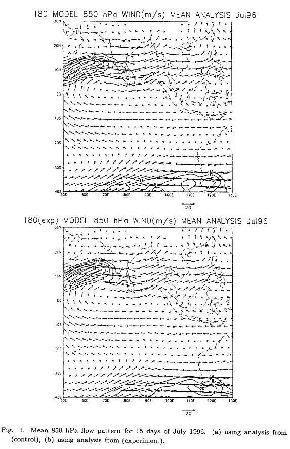
Figure 2 shows the 15 -day mean geographical distribution of specific humidity at 850 hPa level for both control and experimental runs. The experimental run shows, there is less moisture over Uttar Pradesh and Madhya Pradesh area when compared to control run. Hence it is clear that the inclusion of satellite moisture has weakened the mean monsoon flow pattern and has reduced the values in the moisture filed.

But to find, whether these changes in the analysis are in the right direction, the forecast fields from these new reanalysis was examined. During the period 25-27 July there was one system in the Bay of Bengal which formed and intensified. The analysis of flow pattern for 26 July 1996 is shown in Figure 3. The flow in the experimental case shows that the 25 m/s contour is covering a larger area in the Arabian Sea, and the flow near the east coast and along the monsoon trough is reduced. This will have an impact on the rainfall forecast over the land. Figures 4 (a) and 4 (b) show the 48 hours rainfall forecasts, using initial condition of 24 July, from the control and experimental analyses respectively. Over the Orissa and Andhra region the rainfall prediction in experiment case is improved in association with the depression. Figures 4 (c) and 4 (d) show the 24 hours rainfall prediction (from the initial condition of 25 July) for both the control and experiment case respectively. In this case also the rainfall prediction over the Orissa and Andhra Pradesh region is better.

4. Conclusions
Inclusion of moisture profile data from INSAT-IR data has a positive impact on the analysis forecast system of NCMRWF. An improvement in.the rainfall prediction associated with the monsoon flow is noticed. The present method has the potential to be used operationally for analysis and forecast in medium range numerical weather prediction.
Acknowledgements
The authors are grateful to Dr. S. V. Singh the Head, NCMRWF, for his keen interest and encouragement during the period of study. Help rendered by Shri Gopal Iyenger, Athiyaman and Dr. Praveen Kumar Devarajan are duly acknowledged. The INSAT-IR data used in this study are obtained from India Meteorological Department at New Delhi. The authors wish to express their sincere gratitude to the Head, Department of Physics and Astrophysics, University of Delhi, New Delhi for permitting them to carry out this study by giving valuable suggestions.
REFERENCES
Baba, A., 1987. Improvement of the estimation method of moisture data from satellite cloud soundings. JMA/NPD Tech. Report no 16, 48 pp. [ Links ]
Basu, S., R. Gairola, C. M. Kishtwal, P. C. Pandey, A. K. Bohra, D. Rajan, and A. K. Mitra, 1997. Retrieval of moisture profiles using satellite measurements of precipitable water and study of their impact on NWP models. Ind. J. Radio & Space Phy., 26, 49-76. [ Links ]
Diallo, N. T., and W. M. Frank, 1986. Effects of enhanced moisture fields on simulated rainfall over West Africa and East Atlantic. Mon. Wea. Rev., 114, 1811-1821. [ Links ]
Eyre, J. R., 1989. Inversion of cloudy satellite sounding radiances by non linear optimal estimation, Application of TOVS data. Quart. J. Meteor. Soc., 115, 1027-1037. [ Links ]
Haydu, K. J., and T. N. Krishnamurti, 1981. Moisture analysis from radiosonde and microwave spectrometer data. J. Appl. Meteor., 20, 1177-1191. [ Links ]
Mills, G. A., 1983. The sensitivity of a numerical prognosis to moisture detail in the initial state. Aust. Meteor. Mag., 31, 111-119. [ Links ]
Mills, G. A., and N. E. Davidson, 1987. Tropospheric moisture profiles from digital IR satellite imagery: system description and analysis/forecast impact. Aust. Meteor. Mag., 35, 109-118. [ Links ]
Mishra, S. K., and R. K. Bansal, 1997. Report on the performance of operational analysis forecast system during Monsoon - 1996. NCMRWF/DST/ Report no. 2, 159 pp. [ Links ]
Ninomiya, K., and Y. Tatsumi, 1981. Forecast experiment of long-lived subtropical cumulonimbus cluster with 6-level 77 km-mesh primitive model. J. Meteor. Soc, Japan, 59, 709-721. [ Links ]
Rajan, D., A. K. Bohra, A. K. Mitra, R. K. Paliwal, V. S. Prasad, and V. B. Bhatia, 2001. Moisture profiles from satellite data over Indian Ocean area. Inter. J. Remote Sensing. (In press).
Rajan, D., S. R. H. Rizvi, V. B. Bhatia, and H. V. Gupta, 2000. Intercomparison of satellite derived OLR and total precipitable water content over India and their impact on the analysis - forecast system. Ind. J. Radio & Space Phy., 29, 341-348. [ Links ]
Smitt, W. L., 1991. Atmospheric soundings from satellites A false expectation or the key to improved weather prediction. Quart. J. Roy. Meteor. Soc., 117, 267-297. [ Links ]
Wolcott, S. W., and T. T. Warner, 1981. A moisture analysis procedure utilising surface and satellite data. Mon. Wea. Rev., 109, 1989-1998. [ Links ]

