


 text new page (beta)
 English (pdf)
 Article in xml format
 Article references
 Send this article by e-mail
 Cited by SciELO
  Similars in
SciELO
Similars in
SciELO 
 Permalink
INTRODUCTION
The pedogenesis that characterizes volcanic soils begins with the development of A/C type horizons with an incipient humic horizon, which are classified as tephric Regosols (IUSS Working Group WRB, 2015). In humid climates, the evolutionary pathway leads to the formation of Andosols -> Cambisols -> Luvisols ->Acrisols (Parfitt and Saigusa, 1985; Delvaux et al., 1989; Shoji et al., 1993; Sedov et al., 2003; Solleiro-Rebolledo et al., 2015), while in drier climates, the transformation follows the sequence Andosols -> Phaeozems -> Vertisols (Shoji et al., 1993). These transformations initially present the synthesis of volcanic glass and formation of short range minerals such as allophane and imogolite (Wada, 1989). On ageing, these minerals crystalize to halloysite and kaolinite (Fieldes, 1955; Naidu et al., 1987; Nieuwenhuyse et al., 2000). This crystallization, considered irreversible, can also be caused by dehydration of the allophanes (Quantin, 1985; Perret and Dorel, 1999; Woignier et al., 2007).
The physical and chemical properties of volcanic soils confer high fertility, favoring the growth of crops (Ugolini and Dahlgren, 2002; McDaniel et al., 2005; Takahashi and Dahlgren, 2016), and these soils therefore form the base of very productive agroecosystems (Shoji et al., 1993) However, they are fragile systems that can easily suffer degradation as a consequence of land use change (Perret and Dorel, 1999; Fontes et al., 2004; Muñoz et al., 2011; Beck-Broichsitter et al., 2016).
When land use change in volcanic systems leaves the soil temporarily or permanently uncovered by vegetation, this can cause processes of drying, leading to profound transformations not only in its mineralogical composition, but also in its physical and chemical properties, producing a loss of structure and reduced capacity for moisture retention (Perret and Dorel, 2007; Woignier et al., 2007), as well as a diminishing of the organic matter content (Dörner et al., 2009; Beck-Broichsitter et al., 2016)
The southern portion of the Basin of Mexico was affected by intense volcanic activity during the Quaternary period (Siebe et al., 2005), causing the formation of soils with andic properties (Miehlich, 1991; INEGI, 2003; Peña et al., 2015). The Teuhtli volcano, which erupted 36 000 years ago (Guilbaud et al., 2015), is located in the southeastern part of the Basin, in an area that has presented intense agricultural practices since the pre-Hispanic era (Serra-Puche, 1988). The ancient inhabitants settled from the pre-Classical period (1550 BC to 200 AD), developing a complex agricultural system based on terraces (Bravo-Vázquez and Molotla-Molotla, 2007) on soils that, although very fertile, were very susceptible to degradation.
In this work, we studied the physical, chemical and morphological properties of the soils derived from the volcanic materials of the Teuhtli volcano, in zones known as “conserved” and in plots that have had a strong agricultural impact, in order to understand the evolutionary pedogenetic trends of the natural soils and contrast these with those that have been subjected to anthropic impact. This will contribute to the understanding of the evolution of the pedolandscape associated with the peri-urban agroecosystems of Mexico City as well as to evaluate qualitatively the impact of the long-term agricultural practices in the area.
MATERIALS AND METHODS
General Characteristics of the Study Area
The agricultural zone of Pueblo de Santiago Tulyehualco, Xochimilco, is located to the east of Mexico City and extends from the banks of the Xochimilco ex- lake, to the foothill of the Teuhtli volcano (north slope). This volcano forms part of the Chichinautzin volcanic field, in the Trans-Mexican Volcanic Belt (Figure 1). Teuhtli is a monogenetic, scoriaceous volcano, which erupted 36 000 years ago (Guilbaud et al., 2015), producing lava and pyroclastic material of andesitic origin (Siebe et al., 2005).
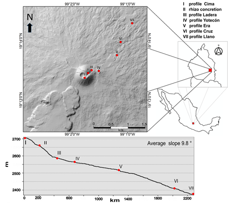
Figure 1: Map of the study area showing the topographic profile and the location of the soil profiles.
The relief of the zone is constituted by the accumulation of pyroclastic deposits, forming foothills with moderate slopes, ranging from 3 to 16% (INEGI, 2003 ). The elevation ranges from 2200 (lake plain) up to 2710 m (volcano crater).
The zone presents a temperate-subhumid climate with summer rains C(W0), with mean annual temperature of 16 °C and mean annual precipitation of 700 mm. The dominant soils of the region are Phaeozems, which cover the agricultural zone close to Teuhtli volcano as well as the habitational zone (INEGI, 2003). In addition to the Phaeozems, Andosols are found in the area close to the crater and on the volcanic edifice (INEGI, 2003).
This zone forms part of the zone of conservation of Mexico City, the total area of which covers approximately 53% of the city (Wigle, 2014). However, in the zone of Teuhtli volcano, the evidence indicates strong deforestation over practically the entire slope, producing an intense erosion of the soils.
Fieldwork
In order to construct the soil toposequence, six profiles were selected: one on the highest part of the volcano (Cima), and two on the upper slope (Ladera, Yotecón) and three on the lower slope (La Era, El Llano, La Cruz) of the volcano (Table 1). The profiles were also selected to represent conserved (never cultivated) conditions and those under agricultural management (cultivated), which are closely linked to position on the slope. Cima and Ladera represent the conserved profiles, El Llano, La Era and La Cruz are the cultivated soils, and Yotecón presents an intermediate condition (it was previously cultivated, but currently presents a coverage of natural vegetation).
Table 1: Localization of soil profiles.
| Profile | Coordinates | Slope | Altitude |
|---|---|---|---|
| % | m | ||
| Cima | 19° 13’ 22.7” N, 99° 01’ 46.4” W | 18 | 2713 |
| Ladera | 19° 13’ 30.3” N, 99° 01’ 38.8” W | 68 | 2611 |
| Yotecón | 19° 13’ 15.9” N, 99° 01’ 31” W | 27 | 2595 |
| La Era | 19° 13’ 45.7” N, 99° 01’ 11.4” W | 13 | 2516 |
| El Llano | 19° 14’ 18.2” N, 99° 00’ 57.9” W | 9 | 2363 |
| La Cruz | 19° 13’ 59.1” N, 99° 01’ 7.4”W | 14 | 2476 |
| Rizoconcretion | 19° 13’ 27.5” N, 99° 01’ 42.8” W | 71 | 2650 |
The soil characteristics were described based on the soil description guide (FAO, 2009). Wet soil colors were determined in the field using Munsell tables (2009). The presence of carbonates was determined using 10% HCl. Samples of each genetic soil horizon were taken for physical and chemical characterization, as well as unaltered samples for micromorphological study.
To establish the chronological framework, two samples of pedogenetic carbonates were taken for radiocarbon (14C) dating by AMS (Accelerator Mass Spectrometry) in the Beta Analytic Radiocarbon Dating Laboratory. One of these samples corresponds to a rizoconcretion found on the upper slope of the volcano, among the pyroclastic deposits, at an elevation of 2620 m (coordinates 19° 13’ 28” N and 99° 1’ 43” W). The second sample is from carbonates found in the C horizon of the Ladera profile (Table 1).
Physical and Chemical Analyses
For the laboratory analysis, the samples were oven dried at 30 °C for 72 h and then passed through a No. 10 sieve (2 mm mesh).
In addition to the color evaluation of all samples with Munsell tables (2009), a colorimetric analysis was done with a Colorlite spectrophotometer of 200 to 800 nm, only for A horizons previously sieved at 0.15 mm mesh, with the objective of establishing criteria for differentiation among the soils. The results were expressed in variables of color: L*(luminosity) a* (red) and b* (yellow) and were compared statistically using a multivariate principal components analysis using the statistical program JMP version 11.
For evaluation of the particle size distribution, the samples were subjected to the following pretreatments: H2O2 at 30% to eliminate organic matter, sodium acetate 1M, pH5, to eliminate the carbonates and dispersion with sodium hexametaphosphate. The sand fraction was separated by sieving. The silt and clay fractions were determined by the pipette method, following the methodology proposed by Flores-Delgadillo and Alcalá-Martínez (2010). Bulk density was evaluated in unaltered samples using the cylinder method and true density determined using the pycnometer method (Flores-Delgadillo and Alcalá-Martínez, 2010).
The values of pH and electrical conductivity (EC) were obtained at a 1:2.5 ratio in water, after agitating for 2 hrs. The pH was measured with a potentiometer Denver Instrument Ultrabasic, with a glass electrode, and the EC was determined using a Oakton 700. The pH was also evaluated in NaF 1M, at a 1:50 ratio, after agitating for 2 min (Van-Reeuwijk, 2002), in order to verify the presence of amorphous minerals.
The concentration of organic carbon was quantified in an elemental analyzer CHNS/O Flash 2000 Thermo Scientific, following elimination of the inorganic forms of C with HCL 2N.
For quantification of total Ca, Ti and Zr (%), the samples were first ground in a ball mill and then passed through a No. 10 sieve. X-ray fluorescence equipment was then used, with an analyzer Thermo Scientific Niton XL3t.
Micromorphological Analysis
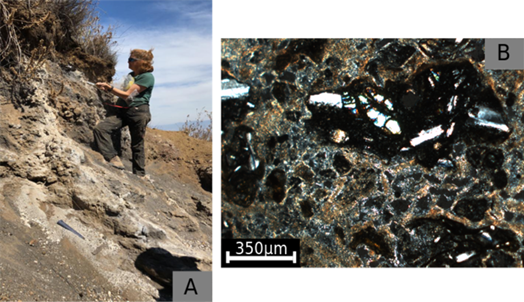
For the micromorphological study, the unaltered samples were air-dried then impregnated with Polyester Crystal resin, prepared and placed in a vacuum at 24 micro-atmospheres. Once the blocks had solidified, they were cut using a diamond circular cutter and polished with silicon carbide numbers 120, 240, 400 and 600 until achieving a thickness of 30 microns. The thin sections obtained were digitized with a scanner Epson Perfection in order to determine the degree of structuration in the soils. The images were then analyzed with a petrographic microscope Olympus BX50.
RESULTS AND DISCUSSION
Morphology of the Studied Soils
The three profiles of the conserved areas are more heterogeneous, showing differences in color and structure.
The profile Cima, located in the crater of the volcano (Table 1), comprises the following horizons: A/Bw1/Bw2/2C. The color of the A horizon (0-25/32 cm) is very dark brown (7.5YR 2.5/2). It presents an undulating limit with the underlying horizon of between 25 and 32 cm. It has a loose granular structure and presents a high density of roots. The Bw horizon (25/35-75 cm) is dark brown (10YR3/3) becoming more yellowish in its lower part (10YR 5/6). The structure is in subangular blocks that break into fragile granules. It has a high content of unaltered pumice. The C horizon (>75 cm) presents a greyish color (7.5YR 5/1) with white areas on the rock surfaces that react with HCl, confirming the presence of carbonates. The rocks present evidence of hydrothermal alteration, given a heterogeneous coloration (Figure 2a). The field classification of this soil corresponds to an Andic Cambisol (IUSS Working Group WRB, 2015).
The profile Ladera, located on the high-slope, shows A/2Bwk/2Ck horizons (Figure 2b). The A horizon (0-32 cm) is black (7.5YR 1/1) and shows a high porosity granular structure. Very abundant fine and medium sized roots are observed, along with fragments of pumice. The 2Bwk horizon (37-48 cm) is yellowish brown (10YR 4/6) with an unstable subangular blocky structure with a high density of fine roots. The 2Ck horizon (> 48 cm) is grey (7.5YR 5/1) showing a high density of roots within the pores. In both 2Bwk and 2Ck horizons the amount of pumice fragments increase which surfaces present a whitish color. All of them react strongly with HCl. It is classified as a Calcic Tephric Andosol (IUSS Working Group WRB, 2015).
The profile Yotecón, located on the upper slope (Table 1), has: Ah/Layer 1/Layer 2/2Bw/2C horizons (Figure 2c). The Ah horizon (0-5/12 cm) is very dark brown (7.5YR 2.5/2) with a very porous granular structure and abundant fine to medium size roots. The limit with the underlying horizon is undulating. Layers 1 (5/12-30 cm) and 2 (30-70 cm) present a high content of rock fragments of different sizes, which are angular and poorly sorted, and indicate colluvial processes (Figure 2c). The 2Bw horizon (70-100 cm) is yellowish-brown (10 YR5/6) with a compact angular blocky structure. The 2C horizon (100-120 cm) is light brown (7.5YR 6/5) and consists mainly of altered pumice. The 2Bw and 2C horizons do not react with HCl. The upper part (A horizon and colluvial layers) is classified as an Andic Colluvic Regosol over Cambisol (IUSS Working Group WRB, 2015).
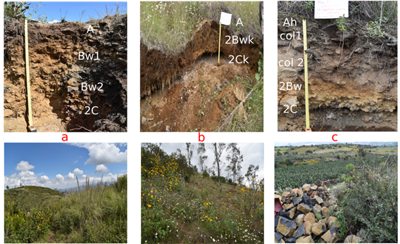
Figure 2: Profiles of the conserved zone, with their respective landscape view: A. Cima; B. Ladera (col means colluvial layer); C. Yotecón.
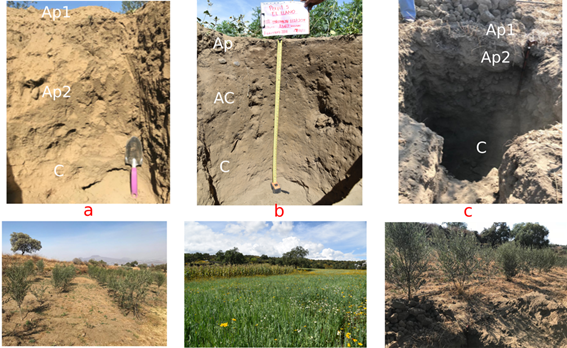
The agricultural soils are found on the lower slope of the volcano. These areas present a strong anthropic management, with the creation of terracing and removal of large rocks. The three profiles have homogeneous colors, which are darker in the surface (Figure 3). Krotovines are observed at 50-70 cm depth.
The profile La Era presents the Ap1/Ap2/ C horizons (Figure 3a). The Ap1 and Ap2 horizons (0-20 cm) show a very porous, unstable granular structure, with a high density fine roots and a high amount of rock fragments. The BC horizon (20-50 cm) has a fragile subangular blocky structure. There is no reaction with HCl. This soil is classified as an Andic Anthrosol (IUSS Working Group WRB, 2015).
The profile El Llano presents the Ap/AC/C horizons (Figure 3b). The Ap horizon presents an unstable granular structure, with fine roots. The AC horizon (15-130 cm) is massive and compacted, with a low density of roots and a high content of rocks. It does not react with HCl. On the contrary, the C horizon (130-150 cm) is poorly and unstable structured. The rocks found here present whitish coverings that react strongly with HCl. The soil is classified as an Andic Anthrosol (IUSS Working Group WRB, 2015).
The profile La Cruz presents Ap1/Ap2/C horizons (Figure 3c). The Ap1 and Ap2 horizons (0-60 cm) have a very loose granular structure, with a high density of fine roots. The Ap2 horizon shows also a subangular blocky structure. At depth 50 cm, ceramic fragments are found. The C horizon (60-90 cm) is also very fragile. A significant increase in rocks that react positively with HCl. The soil is classified as an Andic Anthrosol (IUSS Working Group WRB, 2015).
Physical and Chemical Properties of the Conserved Soils
The profiles Cima, Ladera and Yotecón present a predominance of sand and silt fractions. In all three profiles, there is a notable contrast between the sand content values in the C horizons that of their respective Bw and A horizons (Figure 4). The percentage of clay is low, but with a marked increase in the A horizons.
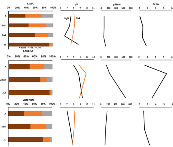
Figure 4: Selected physical and chemical properties of the profiles Cima, Ladera and Yotecón: percentage of sand, silt and clay; pH in water and in NaF; electrical conductivity (µS cm-1) and Calcium content (%).
Bulk density (BD) ranges from 0.92 to 1.45 g cm‑3. The A horizons present the lowest values (Table 2). However, only the A horizon of the Yotecón has a BD typical for andic properties. Regarding the particle density (PD), all of the horizons observe similar values that range from 2.35 to 2.51 g cm-3 (Table 2).
Table 2: Bulk density, particle density, porosity and total organic matter content in the studied soils.
| Profile | Soil Horizon | Bulk density | Particle density | Porosity | TOC |
|---|---|---|---|---|---|
| - - - - - - g cm-3 - - - - - - | - - - - - - % - - - - - - | ||||
| Cima | A | 1.13 | 2.37 | 52.32 | 3.02 |
| Bw1 | 1.27 | 2.36 | 46.19 | 0.77 | |
| Bw2 | 1.25 | 2.31 | 45.89 | 0.48 | |
| 2C | 1.21 | 2.43 | 50.21 | 0.15 | |
| Ladera | A | 1.15 | 2.35 | 51.06 | 1.32 |
| 2Bwk | 1.31 | 2.40 | 45.42 | 0.55 | |
| 2Ck | 1.14 | 2.51 | 54.58 | 0.15 | |
| Yotecón | Ah | 0.92 | 2.36 | 61.02 | 4.86 |
| 2Bw | 1.27 | 2.27 | 44.05 | 0.64 | |
| 2C | 1.45 | 2.44 | 40.57 | 0.21 | |
| La Era | Ap1 | 1.26 | 2.53 | 50.20 | 0.90 |
| Ap2 | 1.22 | 2.44 | 50.00 | 0.48 | |
| BC | 1.27 | 2.46 | 48.37 | 0.50 | |
| El Llano | Ap | 1.31 | 2.50 | 47.60 | 0.88 |
| AC | 1.30 | 2.46 | 47.15 | 0.40 | |
| C | 1.22 | 2.44 | 50.00 | 0.39 | |
| La Cruz | Ap1 | 1.23 | 2.49 | 50.60 | 1.01 |
| Ap2 | 1.30 | 2.64 | 50.76 | 0.45 | |
| C | 1.14 | 2.37 | 51.90 | 0.33 | |
TOC - Total Organic Carbon.
The pH values measured in water range from slightly acidic in the surface A horizons to alkaline in the C horizons. The Ladera profile presents the greatest alkalinity since, even in its surface horizon, the pH values are 8, increasing to 9.3 in the C horizon (Figure 4). The pH in NaF measurements present values close to 8 in all horizons of the prof iles Cima and Ladera, but these values are >9 in the profile Yotecón (Figure 4).
The Electric Conductivity (EC) is variable, with a tendency to increase towards the C horizons, except in the profile Yotecón. The profile Cima presents the lowest values (77 µS cm-1 to 119 µS cm-1), while the profile Ladera has values from 143 µS cm-1 to 633 µS cm‑1. Yotecón shows a higher EC in the A horizon (171 µS cm-1), decreasing to 113 µS cm-1 in the 2C horizon.
The calcium contents are lower in the Cima and Yotecón profiles (between 2 and 3.5%), while in the profile Ladera, an increase is noted in the 2Bwk horizon (reaching 6%) (Figure 4).
The total organic carbon (TOC) content in the A horizons ranges from 1.32% (Ladera) to 3.02% (Cima) and 4.86% (Yotecón), but decreases in the Bw horizons (Table 2).
Physical and Chemical Properties of the Agricultural Soils
In the La Era and El Llano profiles, the silt fraction is the most abundant in all horizons, with values that range from 49 to 58.1%. In contrast to the conserved soils, here, the clay fraction has greater proportions while the percentage of sand is lower, with values below 16.5% (Figure 5). However, the profile La Cruz presents a different tendency, with higher sand contents in all three horizons (> 47%), followed by the silt fraction (>27.1%).
The values of BD and PD are similar to those found in the conserved soils. However, in the agricultural soils, the A horizons do not present a decrease in BD and, consequently, the porosity of these horizons is lower (Table 2).
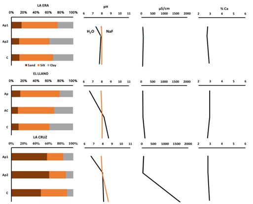
Figure 5: Selected physical and chemical properties of the profiles La Era, El Llano and La Cruz: percentage of sand, silt and clay; pH in water and in NaF; electrical conductivity (µS cm-1) and Calcium content (%).
The tendency observed in the pH measured in water is equal in the profiles La Cruz and El Llano, ranging from slightly acidic to alkaline: the lowest values are presented in the Ap horizons, increasing in the C horizons. The profile La Era presents the most homogeneous pH values, ranging from 7.3 to 7.9, with the latter value detected in the Ap2 horizon (Figure 5). The pH measured in NaF is homogeneous, with values close to 8.
The EC presents variable values; in La Era and El Llano, the EC ranges from 69 µS cm-1 to 160.3 µS cm-1, with the latter value found in the C horizon of El Llano. The profile La Cruz presents similar values in the Ap1 horizon, but increases markedly in the C horizon, with 1653 µS cm-1 (Figure 5). The pattern of calcium content is similar in La Era and El Llano; from 2.8% in the Ap horizon, increasing to 3% in the C horizon. The profile La Cruz presents the opposite calcium content pattern, with 3% in the surface layer, decreasing with depth. The TOC content of these soils is much lower than those found in the conserved soils, being equal to or lower than 1% (Table 2).
Determination of Discontinuities
The Ti/Zr ratio is used to identify the presence of lithological discontinuities within the profiles. The results from the profile Cima reveal no great differences among the A, Bw1 and Bw2 horizons (21.6 to 23.3); however, in the 2C horizon, this ratio increases to 29.4. In contrast, the A horizons of both the Ladera and Yotecón profiles present a marked change in the Ti/Zr ratio with respect to the 2Bwk and 2Ck horizons, reflecting the discontinuity that exists between them (Figure 6). Indeed, in the profile Yotecón, the discontinuity is clearer, since the A horizon is separated from the 2Bw horizon by two layers of colluvial sediment.
In contrast, the agricultural soils present a different pattern, since the ratio has values that are homogeneous and similar across all of their profiles and horizons (Figure 6).

Micromorphology of the Studied Soils
In all of the studied soils, the micromorphological evidence reveals the presence of volcanic material of andesitic composition, predominantly fragments of rock and pumice, volcanic glass, plagioclases and amphiboles, with different degrees of alteration. The main differences between the agricultural and conserved soils can be seen in their A horizons, as described below:
The scanned thin sections of the A horizons of the profiles Cima and Ladera (Figures 7a and 7b) exhibit a general image of their structure, which is more preserved in the Cima profile. These sections show the presence of granules of darker coloration, evidencing a greater content of organic matter. The particle size is homogeneous in both soils (Figure 7a). Under the microscope, a granular, spongy structure is detected, with pigmentations of dark color (Figure 7c) and zones that present second order structures in the form of subangular blocks. The remains of plant tissues and roots are observed in the pores, along with elongated phytoliths (Figure 7d) and abundant fragments of pumice, pyroxenes and plagioclases. The rock fragments have a weathering patina, composed of neoformed Fe oxides. Clay of hydrothermal origin is identified in the interior of the rock fragments. In the profile Ladera, the presence of neoformed micritic carbonates is identified in the pores.
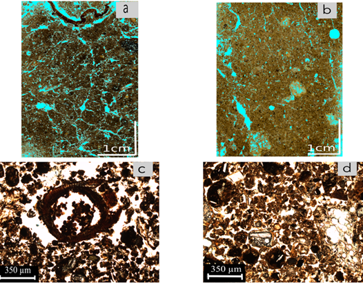
Figure 7: Micromorphology of the A horizons of the conserved soils: a. Scanned thin section of the A horizon of the profile Cima; b. Scanned thin section of the A horizon of the profile Ladera; c. Microphotography of the A horizon of the profile Cima (NL-natural light), with granular aggregates of dark color, enriched with organic matter and remains of plant tissues; d. Microphotography of the A horizon of the profile Ladera (NL), with granular aggregates and volcanic glass.
In the agriculture soils, one of the main observed characteristics is the poor structural organization of the particles (Figure 8a and 8b). In some parts of the section, there are still visible dark pigmentations, associated with micro-granular structures, enriched with organic matter (Figure 8a). However, a weak cohesion is observed among the aggregates in the major part of the slide. Consequently, under the microscope, many pores are identified among the particles, conferring a fragile character to this soil (Figure 8c). Despite the fact that these are surface horizons, neither fresh nor decomposed organic remains are identified. The observed minerals are volcanic glass, pumice, rock fragments of andesitic type with hydrothermal clay, plagioclases and pyroxenes. The periphery of the volcanic glass presents patinas of weathering, of neoformed Fe oxide (Figure 8d).
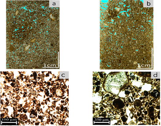
Figure 8: Micromorphology of the A horizons of the agricultural soils: a. Scanned thin section of the Ap1 horizon of the profile El Llano; b. Scanned thin section of the Ap1 horizon of the profile La Era; c. Microphotography of the Ap1 horizon of the profile La Era (NL) with granular aggregates of light coloration and fine material between the granules; d. Microphotography of the Ap1 horizon of the profile La Era (NL) showing low structuration; the rock fragments present a patina of Fe oxides.
On the other hand, in the 2Bwk horizon of the prof ile Ladera, which is practically the only horizon of this type detected in the soils of the zone, the structure presents granular arrangements associated with some subangular blocks (Figure 9A) and dark pigmentations associated with organic matter are not observed. Fine Fe oxides are found around the particles and rock fragments. Likewise, neoformed micritic carbonates of acicular form are observed (Figure 9B) within the pores and the vesicles of the pumice (Figures 9C and 9D).
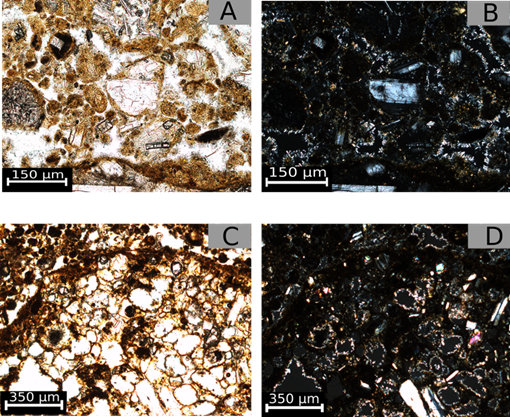
Figure 9: Microphotography of the 2Bwk horizon of the profile Ladera: a. Granular structure with brown tonalities; precipitations of Fe oxides are found around the particles (NL); b. As in A, but with crossed Nicols (NX); c. Fragments of pumice (NL) d. As in C, but with with NX, detecting the presence of micritical carbonates.
Chronological Framework of the Studied Soils
While it is impossible to accurately establish the initiation of the pedogenesis of the studied soils, since the age of the parent material cannot coincide with the soil age, two dates are obtained from the carbonates found in the soils (Table 3). From the 2Ck horizon of the profile Ladera, an age of 5985-6000 years BP is obtained (calibrated age). This age is similar to that found in a rizoconcretion located on the upper slope of the volcano (Table 1), directly on the pyroclastic materials (Figure 10), dated at 4892-4860 years BP (Table 3).
Table 3: Radiocarbon dating of carbonates in the conserved soils.
| Sample | Laboratory code Beta | Conventional date yr. BP | Calibrated date Cal yr. BP (2 sigma) |
|---|---|---|---|
| Carbonates in the C horizon | 520415 | 5250±30 | 6000-5985 |
| Carbonate rizoconcretion | 520416 | 4350±30 | 4892-4860 |
Main Pedogenetic Processes in the Soils of the Teuhtli Volcano
Under similar environmental conditions (as those found in the Tehutli volcano), in south Mexico Basin, Peña et al. (2015) mainly identified Andosol pedogenesis. However, practically no horizon of the Tehutli volcano, in either the conserved or agricultural soils, has a low bulk density, nor values of pH in NaF > 9, necessary for the andic properties designation (IUSS Working Group WRB, 2015). Nevertheless, the profiles of the conserved zones present features that can be associated to the Andosols phase while the bulk density is greater than required. To this respect, Hidalgo (1986) found high values in andic soils of the Sierra Nevada of up to 1.2 g cm-3, due to the high proportion of unaltered volcanic material in the soils. Macromorphologically, the A horizons of the three profiles present a granular structure, are porous and rich in organic matter (Figure 7A and 7B). Under the microscope, they exhibit typical characteristics of Andosol type soils which are very similar to those found by Sedov et al. (2003) and Jasso-Castañeda et al. (2006), who studied the micromorphology of Andosols at Nevado de Toluca. They identified a very stable fine granular structures in which the organic matter is distributed throughout the matrix, conferring a uniform dark coloration. Concerning the agricultural soils, these properties are also presented, but with a lower degree of development. The bulk density is higher (Table 2) and the aggregates are decolored, which is interpreted as a result of the loss of organic matter, producing a weakness structure. The organic matter contents are clearly lower than those of the conserved zones (Table 1). However, under the optical microscope, the granular aggregates can still be identified, “floating” in fine materials (Figure 8C), which coincides with the granulometry detected in these soils, in which the silt fraction dominates (Figure 5).
In this way, it is possible to establish that the genesis of both the conserved and agricultural soils of the zone has been promoted by the process of andosolization, particularly identified by the development of granular structure, high porosity and high organic matter content (Shoji et al., 1993). However, these properties have been modified due to degradation processes (see further).
Another of the identified process in the soils of the Teuhtli volcano is that related to the formation of pedogenetic carbonates. These carbonates were detected in the Cima, Ladera, El Llano and La Cruz profiles as well as interlayered with pyroclastic deposits and forming rizoconcretions (Figure 9). In the conserved soils, the positive reaction with HCl in some horizons as well as the identification of micritical carbonates in the pores and cracks (Figure 9D) are evidence of their presence. In the agricultural soils, they are detected only on the rocks surfaces in the deepest horizons. This information also correlates with the highest percentages of Ca and with the highest pH and EC values found at these levels (Figure 5).
The formation of carbonates in the soils is explained by the dissolution-precipitation of bicarbonate ions, in the presence of a rich source of Ca2+ (Zamaniam et al., 2016). There is no presence of calcareous rocks in the surroundings of the Teuhtli volcano. Consequently, the main source of Ca2+ is the minerals of volcanic origin, such as the plagioclases. These primary minerals rich in Ca2+ react in the soil solution that contains H2CO3, a product of the CO2 respired by microorganisms and H2O. Few studies have documented the genesis of pedogenic carbonates on non-calcareous materials, especially on igneous substrates (Durand et al., 2006; Shankar and Achyuthan, 2007; Yousefifard et al., 2015). The precipitation of the carbonated solution in the form of calcium carbonates requires conditions of drought (Durand et al., 2007). A semi-arid environment would be ideal for their formation, since it provides sufficient humidity to weather the parent materials and precipitate the carbonates during the dry season (Durand et al., 2007; Tanner, 2010). The current environmental conditions in the studied area with an annual precipitation of 700 mm and a mean annual temperature of 16 °C would favor the formation of carbonates.
Chronology and Evolution of the Soils of Teuhtli Volcano
Two fundamental factors drive the evolutionary trends of soils derived from volcanic ash: time and climate, which control the intensity of weathering (Ugolini and Dahlgren, 2002). As stated above, the deposits of Teuhtli volcano are 36 000 years old (Guilbaud et al., 2015), which could mark the beginning of the pedogenesis, since the volcanic ash weathers a short time after its deposition (Shoji et al., 1993). According to the research of Miehlich (1991), it could be expected that the soils would present a greater evolution, considering that the Andosol phase is “lost” after 10 000 years, forming Luvisols or Acrisols in humid climates (Parf itt and Saigussa, 1985; Gracheva et al., 2001; Sedov et al., 2003; Solleiro-Rebolledo et al., 2015) and Phaeozems and Vertisols in semiarid climates (Shoji et al., 1993). Indeed, in the southern portion of the Basin of Mexico, Ibarra-Arzave et al. (2019) document that the Andosol phase is presented in young soils, but with a greater time of pedogenesis, Luvisols are formed. Peña et al. (2015) indicate that the evolution of andic properties presents a linear behavior in the first 10 000 years. However, the Andosol phase is still present in the conserved soils, despite the age of the parent material. In the agricultural soils, this phase is also recognized (Figure 8C and 8D), although there is a strong deterioration of the structure. This raises some questions: What limits the evolution of the soils? Does their position in the landscape promote processes of erosion and colluviation on the upper slopes? or is it the result of anthropic management or climate?
The presence of lithological discontinuities are detected in the soils of the conserved zones, through the Ti/Zr ratio (Figure 6), indicating that the A horizons of the profiles Ladera and Yotecón are not formed from the same parent material as their Bw and C horizons. This is obvious in Yotecón, in which the horizons are clearly separated by colluvial layers, but not so in Ladera. In this profile, a clear difference in noted since the Bw and C horizons contain abundant pedogenetic carbonates, not observed in the A horizon. The radiocarbon ages of a rizoconcretion on Tehutli tephras and carbonates in the C horizon of the prof ile Ladera range from 4860 to 6000 years BP (calibrated), which places their formation in the mid Holocene. With this age, we can correlate these pedogenic carbonates with others found in north Mexico Basin. For instance, in the region of Teotihuacán, Solleiro-Rebolledo et al. (2011) and Sánchez et al. (2013) report the presence of carbonates in a BCk horizon, which age is 5910-5740 years BP. In addition, Sedov et al. (2010) also document the presence of soils with carbonates that correspond to the same age, in the area of Tepexpan. In all these works, the pedogenic carbonates formation is associated to drier environmental conditions.
It can therefore be considered that various natural processes control the evolution of the soils of Teuhtli volcano:
-. processes of erosion-deposition and colluviation, which removed the already formed soil and reinitiated the pedogenesis,
-. variations in the climatic conditions, which became drier in the mid-Holocene and modified the natural evolutionary tendencies,
-. anthropic management, which has led to deforestation in the zone and promoted and intensified the processes of erosion.
It was expected that part of the soils, eroded from the upper slopes, would be found in the agricultural zones on the lower slopes, but this does not appear to be the case, since those profiles are very homogeneous with no detection of lithological discontinuities (Figure 6).
Variations in the Natural Pedogenesis as a Result of Agricultural Activities
As stated above, the conserved soils of the Teuhtli volcano are found on the higher positions, which currently belong to protected zones of conservation. However, in the sites of the lower slopes, the land use is agricultural and habitational, and this has produced changes in the pedogenetic properties. One of the most notable is the change of the structure and microstructure of the soils. In the scanned images of the A horizons thin sections, the structure shows that the granular aggregation have been lost. This is more clearly observed in the A horizons of the agriculture soils (Figure 8A and 8B). This loss of structure is more evident in the photographs taken under the optical microscope (Figure 8C and 8D). This loss is linked to the diminishing of the organic matter content (Table 2) that causes the micro-aggregates to “float” in a finer micro-mass (Figure 8C). However, the aggregates of the Andosol phase remain still conserved in these soils affected by agriculture (Figure 8C and 8D). Similarly, Nakatsuka and Tamura (2016) identify granular structures and large porous spaces of vesicular form in Andosols in Japan that are subjected to both conservation and traditional tillage practices. The authors suggest that this microstructure has a high resistance to modification through tillage activities.
Another change detected in the agriculture soils is the increase of the bulk density, with values ranging from 1.23 to 1.30 g cm-3 (Table 2), as a result of the tillage. These data correlate with the low structuration observed in the micromorphology (Figure 8C). Various studies indicate that soils of volcanic origin that are subjected to intensive tillage and livestock grazing can undergo significant changes in the structure and porosity (Muñoz et al., 2011; Dec et al., 2012; Fleige et al., 2016). Seguel and Horn (2005) have experimentally evaluated the mechanical behavior of volcanic soils, determining modifications to the hydraulic properties, as a consequence of the effect of load, that lead to soil degradation, particularly in the form of erosion.
The observed change in color (lighter colors in the A horizons, and the color homogenization) is attributed to the loss of organic matter. The results of the principal components analysis of the colors, detected with the colorimeter, group all of the Ap horizons of La Era, El Llano and La Cruz, which present higher values of L that correspond to the lighter colors (Figure 11). The A horizons of the profiles Cima, Ladera and Yotecón show a more heterogeneous distribution, but it is notable that each of the A horizons presents low values of L* and high percentages of TOC (Table 2).
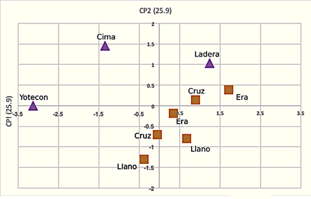
Figure 11: Statistical of principal components analysis of the color (by colorimetry) of the A horizons in the conserved soils and the Ap horizons of the agricultural soils.
Agricultural activities have been conducted in this zone for several hundreds of years, since the ancient inhabitants settled the lower slopes of the Teuhtli volcano in the 12 century, mainly cultivating maize, beans, squash, chili and amaranth (Serra-Puche, 1988). Field evidence shows that the foothills have been profoundly modified as a consequence, with the creation of a system of terraces and transport of rocks and materials on the terrace boundaries, which are also used to prevent erosion. Furthermore, the presence of ceramics has been detected at different depths, which confirms the use of these terraces since the pre-Hispanic era.
CONCLUSIONS
- The soils of Teuhtli volcano, located to the south of the Basin of Mexico, present two pedogenetic processes: andosolization and carbonate formation. The andosolization phase is detected mainly by the micro-aggregation of the structure, the high porosity and high organic carbon content. Despite the age of the parent material (36 000 years), the Andosol phase has not been lost. However, various studies find that the transformation of Andosols to Luvisols in the Trans-Mexican Volcanic Belt occurs after a period of 10 000 years (Miehlich, 1991; Sedov et al., 2003; Solleiro-Rebolledo et al., 2015). The explanation for this lies in the geomorphological dynamics of the zone, in which the processes of erosion and colluviation promote soil loss, restarting the pedogenetic clock. Likewise, the detection of lithological discontinuities allows establishment of the contribution of younger volcanic materials. In this regard, it is known that the deposits of the Teuhtli volcano, particularly on its southern slope, are found below the Tutti-Frutti Pumice (age 17 000 years) and the Grey Ash (age 31 000 years), which are products of the activity of the nearby Popocatépetl volcano (Siebe et al., 1995 and 2005; Guilbaud et al., 2015).
- Formation of the carbonates is governed by the seasonal conditions of drought currently presented in the zone; however, their age places their formation in the mid-Holocene, a period where drier environmental conditions are detected in other sites of the Basin of Mexico.
- The agricultural land use in the zone has promoted morphological, chemical and physical changes in the soils. However, micro-aggregation features are still present, related to the previous Andosol phase. The continuous tillage of the sites has degraded the soils, affecting the organic matter content. This could have a negative effect on the fertility of those soils currently used to sustain the peri-urban agroecosystems of Mexico City.

