


 text new page (beta)
 English (pdf)
 Article in xml format
 Article references
 Send this article by e-mail
 Cited by SciELO
  Similars in
SciELO
Similars in
SciELO 
 Permalink
Introduction
Human development has been linked with countless manipulations of ecosystems, which in turn give rise to modifications to their components, processes and functions (UNEP, 2005), varying according to the particular aspects of the disturbance (Wali, 1992), as seen in the ecosystems' transformation, degradation, damage or destruction (SERI, 2004). Any of these processes may give rise to hybrid systems or new systems (Seastedt et al., 2008; Hobbs et al., 2009), but the current climate variability and a greater recurrence of extreme hydrometeorological phenomena contribute to worsen impacts (Williams and Jackson, 2007; Hobbs et al., 2011), putting human well-being at risk.
To distinguish natural ecosystems from those that have been manipulated or transformed by human action, different terms are used to characterize the type of manipulation made, the extent of transformation, and the historical, cultural and economic relations forged by society with nature. For these social-ecological systems (SES) to benefit humanity over time, the recovery and maintenance of their environmental services must be fostered. This point to the need to invest in ecosystem management through restoration actions (Aronson et al., 2007; Cervantes et al., 2008; Bullock et al., 2011). However, to ensure better decision-making regarding the action to be taken, the SES must be appropriately understood (Hobbs and Cramer, 2008). In this regard, diagnosis is a process to obtain, analyze and summarize information to determine a SES's condition. Its main goal is to discern and define causalities, while also offering possible scopes and solutions (García, 1994; Moran et al., 2006).
Comprehensive studies of environmental systems emerge when detecting the existence of complex issues that are determined by the confluence of several factors. The goals of this type of study are to (1) obtain a diagnosis of the system's operation to understand the consistency or inconsistency of its components and the repercussions on its overall behavior, and (2) enable action in the system to halt and, to the extent possible, reverse the processes that impair it, based on alternatives for involvement and policies that enhance its development (García, 2007).
In this paper, we examine the special relationship between indigenous peoples and their SES. The objectives of this study were to (1) obtain a diagnosis of the San Nicolás Zoyatlan SES to understand the consistency or inconsistency of its components and the repercussions on its behavior, (2) summarize the disturbance factors that, over time, contribute to the determination of such condition, (3) select opportunities to foster restoration activities considering the SES's condition, the population's interests and needs, and cultural baggage vis-à-vis the management of the territory, and (4) establish rehabilitation action in this SES.
Methods and materials
Area of Study
San Nicolás Zoyatlan (hereafter referred as Zoyatlan) is one of the 894 farm communities that make up the region called "La Montaña" in the State of Guerrero (Figure 1). This region is characterized by hilly terrain and a highly complex ecology. It is home to more than 318 000 inhabitants (Conapo, 2005). A significant portion of the population is indigenous, with three main ethnic groups: Mixteco, Nahuatl and Tlapaneco. La Montaña is among the Mexican zones with the highest socioeconomic marginalization (INEGI, 2010) and major environmental degradation problems (Carabias et al., 1994; Cervantes et al., 1996a).

Zoyatlan belongs to the Xalpatlahuac municipality (Figure 1), where the population is mostly of Nahuatl origin. The climate is warm, sub-humid; the average annual temperature is 27.5 °C, with no frosts. The rainy season occurs during summer, with average annual precipitation of 781 mm and a P/T quotient of 30.2. November to April is a period of water shortage, while the wet period is from May to October. Like other areas in La Montaña with warm climates and predominance of tropical deciduous forests (TDFs), Zoyatlan has high deforestation rates and soil degradation issues (Landa et al., 1997; Pérez-Reyna et al., 1998).
Our research uses tools taken from the environmental and social sciences, whose application and interaction depended on the stages of the diagnostic process. The results discussed in the following paragraphs are based on the in situ studies of SES analyzed. We began the diagnostic studies in 1995, and the stages enabling an understanding of the current status of the Zoyatlan SES and the factors explaining its condition were completed in 1998. As regards the design and application of restoration strategies, we provide a summary of results for the period from 1996 to 2001. We are currently conducting an assessment of the developed restoration strategies; results to date are discussed in light of those previously obtained and consider their future outlook.
Characterization of the Biophysical Environment
Starting with field visits with key informants, using GPS and 1:50 000 topographical maps (INEGI, 1983), we established the SES's boundaries. Then, using GIS software, we created a SES base map at a 1:20 000 scale. Using this map, information was generated and refined in situ with respect to different physical factors: lithology, altitude, slope, orientation and landforms; these factors were associated with the different types of plant cover and soil characteristics. For its cartographic representation, 143 inspection sites were defined and georeferenced. In 36 of these sites, we drew 513 m2 quadrants where comprehensive sampling was done based on soil profiles and a description of the vegetation's structure and composition. In the other 107 sites, we described the plant cover according to its physical features and structure. The lower stratum contained weeds and grasses, while the woody vegetation was characterized by sites featuring shrubs and trees of < 5 m height (referred to as secondary shrub vegetation), distinguished from trees of > 5 m (referred to as secondary tree vegetation). We also describe 37 soil profiles.
Laboratory techniques used for the analysis of soil samples of 73 profiles were the following: texture, determinate by the USDA-SSS method (1994); soil erodibility, assessed in accordance with Wischmeier's nomogram (Wischmeier and Smith, 1978); soil total organic matter, determined with the procedure described by Blackemore et al. (1981); cation exchange capacity, extracted with 1M NH4OAc to pH 7 (SCS-USDA,1984).
Forms of SES appropriation by Zoyatlan's inhabitants
To identify the disturbance factors affecting the SES, we investigated how natural resources are appropriated as well as the socioeconomic characteristics of the population. We conducted 36 unstructured interviews with key informants to obtain information on land ownership, the population's productive and economic activities and the quality of the worked land. We also reviewed the community's population censuses.
To understand the disturbance factors that have affected the SES in the past, we documented the town's history and the historical use of resources in Zoyatlan, using a methodological tool often used in anthropological studies, the monograph. We reviewed different documentary sources, such as the Mexican National Archives, Xalpatlahuac church archives, the Zoyatlan Archives, and the National Farm Register. This information was complemented with available literature on the region (Muñoz, 1963; Vega, 1991; Dehouve, 1991; 1994; 1995) and with 12 unstructured interviews with key informants, members of the council of elders, and civil and religious authorities, to identify events associated with the use of natural resources that the inhabitants of Zoyatlan recall as being most relevant.
With information obtained in the two steps described above, we designed a genealogical survey; which was aimed at families. The genealogical survey enables the collection and organization of information by generation and by family unit (FU) (De Teresa, 1992). This included 152 questions organized into the following topics: (1) FU origins, (2) type of FU, (3) demographic structure of the FU, (4) labor activities of the FU, (5) history, location and characteristics of the FU's plots. The survey was conducted with 22 FUs, selected on the basis that at least one of its owned plots had been comprehensively sampled for soil and plants.
Restoration Strategies
We set up agroforestry systems (AFSs) and plantations (PLs) on the plots, in both cases using species native to the TDF in the region of study. The plants were reproduced in the Zoyatlan nursery; in this regard, we revisited studies on species biology, distribution and propagation techniques (Arriaga et al., 1994; Cervantes et al., 1996b; Cervantes et al., 1998), in addition to undertaking other studies to increase the species inventory, obtaining seeds in the proper quantity and quality, preserving their viability ex situ and adapting propagation techniques to nursery (Cervantes et al., 2001).
The AFSs included living fences of shrub and tree species and monospecific strips of tree species within the plots. The planting density in PLs was 1200 plants/hectare, while AFSs were adapted to the land area and each FU's farming needs. AFS and PL monitoring included measuring the survival and growth of plants and quantifying their coverage, diameter and height; these activities were done annually from 1996 to 2001. A second evaluation period for plant growth was conducted from 2011 to 2013.
Results and discussion
Current Condition of the Zoyatlan SES
Physical environment. According to the base map, the agrarian community of Zoyatlan features an area of 924 hectares. The community has a complex topography, with altitudes ranging from 1300 to 1800 meters above sea level (Figure 2). Only 5.5% of the terrain is level or slightly sloped (0 - 3°), found in the valleys and rounded hilltops, while sloped hillsides (> 20°) extend over more than a third of the territory. We classified the different landforms into eight different types. Hills and summits dominate the landscape, together accounting for 83.6% of Zoyatlan's total area. In contrast, the alluvial fan, colluvial lands, terraces, beaches and river plains occupy only 14.1% of the territory.
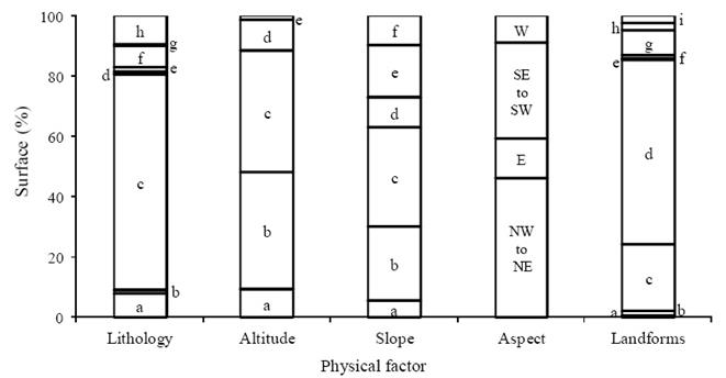
Figure 2 Proportion (%) of the surface occupied by environmental factors in Zoyatlan (Guerrero, Mexico). Lithology: (a) alluvium, (b) andesite, (c) quartzite breccia, (d) volcanic breccia, (e) limestone, (f) sandstone conglomerate, (g) lutite-sandstone, (h) tuff. Altitude (masl): (a) ≥ 1300 ≤ 1400, (b) > 1400 ≤ 1500, (c) > 1500 ≤ 1600, (d) >1600 ≤ 1700, (e) > 1700. Slope: (a) ≥ 0° ≤ 3° ≤ 10°, (c) > 10° ≤ 20°, (d) > 20° ≤ 30°, (e) > 30° ≤ 38°, (f) > 38°. Aspect: NW to NE = northwest to northeast, E = east, SE to SW = southeast to southwest, W = west. Land forms: (a) alluvial fan, (b) colluviums, (c) summit, (d) steep slope, (e) hill slope, (f) beach, (g) terraces, (h) badland, (i) river plains.
Fieldwork showed a varied lithology in this area, consisting of volcanic and sedimentary materials, with quartzite breccias being the most representative (Figure 2). Due to the type of lithology and the zone's characteristically low weathering, we found that soils lack a B horizon and present only an A horizon. Under the WRB (2006), these soils are classified as Anthropic Regosols and Mollic Leptosols. Both soils are common in mountainous areas and characterized as being shallow and rocky, limiting their farm use as their position makes them susceptible to degradation.
Laboratory analyses of these soils indicated the presence of physical and chemical characteristics that favor fertility: adequate water retention capability and cation exchange capacity (CEC), good organic matter (OM) content and moderate erodibility on the topsoil (Figure 3). These characteristics are atypical for soils that have not been deeply transformed by human handling (Cervantes et al., 2005). Soil limitations are identified by Zoyatlan's peasant farmers, who have an in-depth knowledge of the soils in their territory, as summarized in a folk classification. According to Cervantes et al. (2005), this classification recognizes six soil types, each with different agronomic qualities and vulnerabilities to water erosion (Table 1).
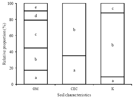
Figure 3 Physical and chemical characteristics of the soils samples obtained in Zoyatlan (Guerrero, México). SOM % =soil organic matter: (a) < 1, (b) > 1 ≤ 2, (c) > 2 ≤ 3.5, (d) > 3.5 ≤ 5, (e) >5. CEC cmol(+1)kg-1 = cation exchange capacity: (a) ≥ 11 ≤ 25, (b) > 25. K = erodibility: (a) ≤ 0.20, (b) > 0.20 < 0.35, (c) ≥ 0.35.
Table 1 Ethnolinguistic terminology used in Zoyatlan (Guerrero, Mexico) for diagnostic soil features and designation of the distinct properties of topsoil (Cervantes et al., 2005, modified).
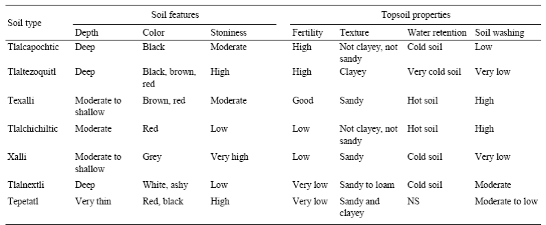
Cold soil = high water retention, Hot soil = low water retention, Soil washing = water erosion, NS = not specified.
Vegetation. The 70.8% of Zoyatlan's total area presents some type of woody vegetation; its state and cover are represented by disperse patches. According to Rzedowski's classification (1978), the vegetation types found and their distribution in 1998 were as follows: (1) tropical deciduous forest, 65.1%; (2) riparian forest, 3.3% and (3) Juniperus forest, 2.4% (Figure 4).
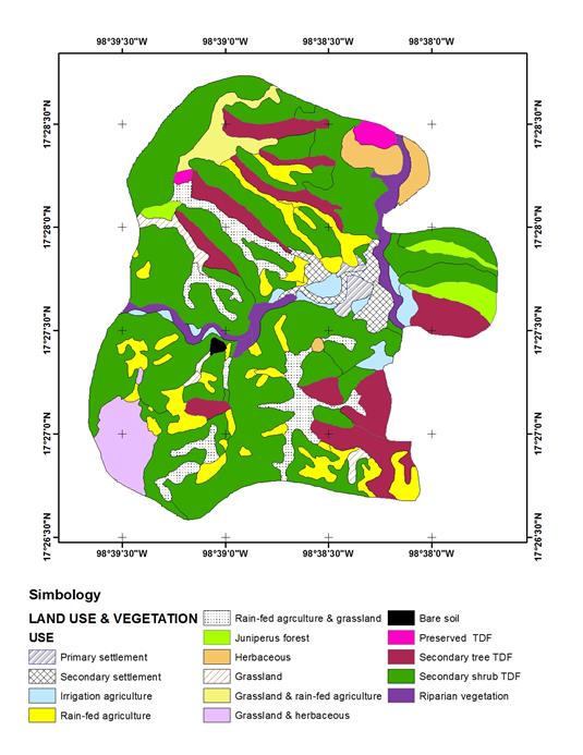
Figure 4 Vegetation and land use in 1998 of Zoyatlan (Guerrero, México). TDF = tropical deciduous forest. 1979 - Primary settlement only, 1998 - primary and secondary settlement.
In 1998, only two patches of tropical deciduous forest (TDF) remained in a moderate state of conservation, with an area of 8.08 hectares. These areas were found at altitudes above 1350 m on andesite and limestone lithologies, steep hillsides and summits, and facing N, NE and NW (Figure 4). In contrast, 64.2% of the total area was covered by secondary shrub vegetation (478.07 hectares) and secondary tree vegetation (113.65 hectares), distributed from 1400 to 1650 m, primarily on quartzite breccias lithology, sharing its orientation and terrain preferences with the TDF (Figure 4). The most representative taxonomic families were Asteraceae and Fabaceae (Figure 5).
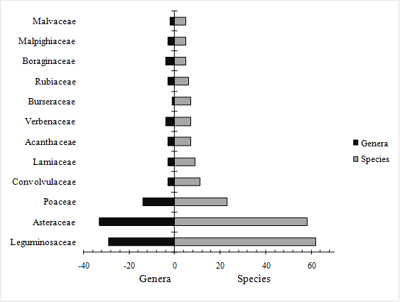
Figure 5 Taxonomic families presenting five or more species in the floristic study of Zoyatlan (Guerrero, México).
Regardless of variations in structure and composition of the vegetation in the TDF patches, these are located on slopes more than 21° predominantly North-facing and on soils between 5 and 20 cm deep. Erodibility values of these soils are moderate and the dominant texture is sandy clay loam. Also, SOM content varies from 3 to 15% and CEC was always above 25 cmol (+1) kg-1 Although natural fertility of these soils is high, their shallowness and difficult access limits their use for agriculture, which is why the peasants include them in their classification as Tepetatl (Table 1).
The riparian forest extends over 30.27 hectares along the Ahuehuetla and Montaña rivers, where the characteristic species is Taxodium mucronatum. The Juniperus forest, where Juniperus flaccida dominates, is the least represented type of vegetation (22.03 hectares). It is found primarily on limestone rock at altitudes above 1400 m and on steep slopes and summits facing N and NW (Figure 4)
Socioeconomic Aspects
Population. In Zoyatlan, population settlements are located very close to the community's most important water flows (Figure 4). In 1998, residential land use accounted for 3.17% of the territory's total area, with 118 houses. During the 20th century, Zoyatlan saw major population growth (Figure 6). In 1998, the total population was 681 inhabitants, distributed among 116 family units (FUs) averaging (±1 S.D.) 6.4 ± 0.5 members per unit. This trend explains the growth of human settlements, which nearly quadrupled in area between 1979 and 1998 (Figure 4).
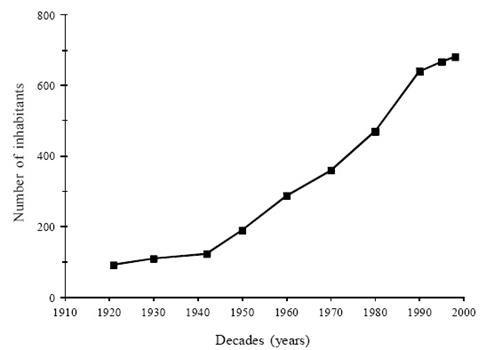
Figure 6 Population growth of Zoyatlan in the 20th century. (Sources: INEGI 1985, Community Census 1940, 1980, 1998, 2000).
Land ownership and productive activities. In 1998, families in the Zoyatlan farm community lacked certified titles of ownership. However, within the community, there are two types of ownership-small holdings and communal property. The community's lands are fully parceled; access is controlled by the group of owners who acquired ownership by inheritance or purchase.
The common-use area is sparse (20 hectares) and farming, stockbreeding and firewood gathering is contingent on the land ownership structure accordingly. Of the total family units (FUs), 73.3% have farmland, but only 23.5% have irrigated farmlands. The farming area held by FUs is highly variable: 25.4% of families hold < 1 hectare, 57.6% have areas ≥ 1 but ≤ 3 hectares, and only 17% of FUs hold planting areas of > 3 hectares. The most important unpaid activities are agriculture and goat breeding (Table 2). The main crops are maize, beans and "champula" squash. Farming is based on family work, but sometimes local labor is hired. Although several wage-based activities are carried out, itinerant and seasonal migrations play a significant role. The former is solely national, occurring when there is no farm work. The latter involves migrants to the United States for periods of ≥ 5 years (Table 2). Although seasonal migration is currently more frequent, Cervantes and De Teresa (2004) suggest that both types have contributed to improving the families' reproductive conditions and survival. While itinerant migration at one time favored access to farmland, the remittances provided by seasonal migration not only address families' different needs, but also foster the diversified use of natural capital and helps alleviate pressure on SES use.

Land use in Zoyatlan is highly varied; hillsides are used for the gathering forest products and for stockbreeding. Flat hilltops, terraces, alluvia, colluvia and river plains are used for farming. In 1998, only 0.16% of the territory's total area was bare soil (Figure 4). The area intended for farm activities extended to 25.9%, with seasonal agriculture and stockbreeding predominating, as irrigation agriculture occupied only 2.1% (20.89 hectares).
Forestry activities. Non-timber forest resource gathering includes plants, coppices, fruits and seeds for human consumption and medicinal uses, as well as resins and fodder. Timber resources are extracted for fence construction, tools and fuel. The most important forestry activity in 1998 was firewood collection, as 90% of FUs used firewood as the primary source of energy for cooking. A study conducted to evaluate fuel availability in certain regions of the warm and tropical zones of the La Montaña region (Masera et al., 1997) showed that Zoyatlan's firewood supply is insufficient to cover the population's energy needs.
Stockbreeding. Children, the elderly and housewives participate in this activity, since it does not demand much physical exertion. There are two husbandry systems in Zoyatlan: multi-specific or backyard breeding done on the family's home plot, and free-grazing goat breeding aimed at specific zones. Goat breeding, with 450 goats in 1998, is a topic of interest for two reasons: its possible repercussions on the degradation of vegetation and soil, and its relative economic importance, as it represents savings used to solve families' unforeseen economic needs.
While production techniques are little used in stockbreeding, not all FUs engage in goat husbandry due to the following prerequisites: (1) a certain degree of capitalization for the initial investment; (2) a family structure conducive to shepherding by at least one member, and (3) owning sufficient land to maintain the herd. During the rainy season, the flock usually grazes on areas adjacent to farm plots, while in the dry season grazing is done on the farm plots where livestock feed on harvest residues, as well as in areas with woody vegetation owned by the producer.
Agriculture. In the rain-fed agriculture area (218.20 hectares), the landscape varies continuously (Figure 4). In accordance with cover dominance, we classified these landscapes into six categories: (1) rain-fed agriculture, (2) rain-fed agriculture and grassland, (3) grassland and rain-fed agriculture, (4) grassland and weeds, (5) weeds, and (6) grassland. In 1998, the area used for rain-fed agriculture or its combination with stockbreeding (categories 1 to 3) was 154.53 hectares, while the area intended solely for livestock or perhaps fallow (categories 4 to 6) was 63.67 hectares. This indicates that at least 30% of the area intended for rain-fed agriculture had a fallow period, reflecting the existence of different intensities of farmland use.
Five farm production systems are practiced in Zoyatlan, with the use of human labor common to the middle and upper categories. Dependence on rain was nearly generalized for crop development. The main difference lies in the frequency of agricultural use of the soil (Table 3).
Table 3 Characterization of agricultural production systems in Zoyatlan (Guerrero, Mexico) in 1998.
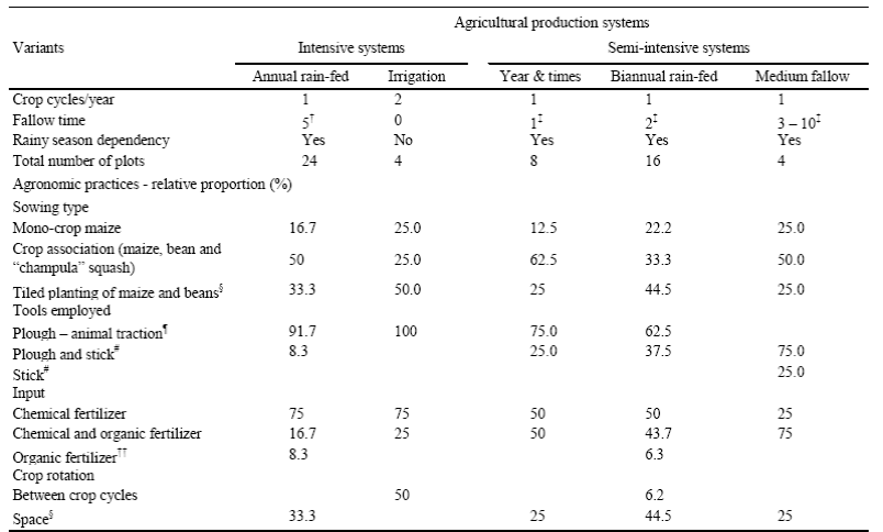
† month, ‡ year(s). § One portion of the same land and farm cycle is used to plant maize, while the other is used to plant the studier common bean; the crops are switched in the same space for the next planting cycle. ¶ Medium investment in human labor, # High investment in human labor, †† Includes black soil and ant, bat and ruminant droppings.
Our surveys looked into particular aspects of farm management on 56 FU plots. We found two variants of intensive farm use on 50% of the lands; in the remaining portion, fallow of ≥ 1 year was common (Table 3). As regards agronomic practices, we note that seasonal lands feature planting associated crops and combinations of different types of tilling as relatively frequent practices. The presence and recurrence of these practices is notable because they contribute to buffering soil erosion. Although chemical fertilizer was used in all farm systems, in rain-fed systems we found that the tendency was to combine chemicals with natural fertilizers between growing periods. This practice is relevant insofar as it helped to improve soil structure and fertility. Another FU activity is crop rotation over space and time, which although less frequent also helped to maintain soil fertility (Table 3). Based on the chemical fertilizer dosage recommended for the La Montaña region, Toledo and Pérez (1994) indicated that 60% of the families in Zoyatlan use low doses of these fertilizers. Although they concluded that this is because fertilizers represent an unaffordable expense for FUs, though there is no evidence that economics is a wholly determining factor. Based on the surveys, we confirmed that part of the economic resources contributed by seasonal migration were used to subsidize farming, facilitating acquisition of synthetic inputs, rental of draft animals and, on occasion, hiring day laborers to assist in farm work. This fact suggests that there are other elements influencing the decision to use chemicals. In Zoyatlan, combinations of fallow periods, crop association and rotation, types of tilling and the use of natural and synthetic fertilizers are usually related to the soil's natural fertility, which peasant farmers recognize on their lands according to their soil classification (Table 1). According to Cervantes et al. (2005), peasants cultivate Tlalcapochtic and Tlaltezoquitl soil every year and occasionally use nitrogen fertilizer. In contrast, on Tlalchichiltic and Tlalnextli soils they generally use fertilizers with nitrogen and phosphorus and fallow periods are always longer than a year (Tables 1 and 3).
Moreover, although the factors inherent to the demographic and economic characteristics of FUs influence agricultural management practices (Cervantes and De Teresa 2004), they do not seem to dictate substantial changes in soil use intensity patterns. For example, the planted area per FU in 1998 increased in direct proportion to its size (R2 = 0.208; F = 4.727; P = 0.043) and to the number of members of productive age (R2 = 0.224; F = 5.186; P = 0.035). However, regardless of the area owned per FU, in 1998 all units cultivated a portion (between 5% and 85%) of their lands.
This suggests that families manage their natural resources and workforce both to satisfy their immediate food needs and to ensure the future of the natural capital that provides their goods and services. While the rationality of subsistence agriculture is irrelevant in terms of its commercial value, stewardship of the soil and the space-time order imposed on farm and forestry usufruct point to inhabitants' appreciation of the services offered by their SES. Given these facts, we must look back to the stage of degradation of the vegetation existing in Zoyatlan in 1998. What factors or circumstances contributed to the near nonexistence of preserved TDF and the dominance of shrub vegetation in more than 50% of the territory?
Past Disturbance Factors
According to the monograph (Cervantes and De Teresa, 2004), Zoyatlan is an ancient community. Although there is no specific record of its founding date, historical documents indicate that it was already operating as a consolidated social organization by 1490.
Based on historical records from tributary peoples, it may be inferred that the socio-ecosystem sustained itinerant and irrigation-based agriculture and the gathering of forest products. After the conquest of Mexico, new forms of appropriation of natural and human resources were instituted in the La Montaña region. From 1650 to 1810, the most notable feature was the increase of estates engaged in farming, pasturing and pass-through grazing. During the 17th century, Zoyatlan formed part of a grazing "hacienda", whereby the social-ecological system was used both for agriculture and for transhumant flocks of goats and sheep herded by different villages from La Montaña.
In the late 18th century, numerous peoples were emancipated in the region, creating their own governments. Zoyatlan was consolidated as part of this process in 1767. Although this allowed Zoyatlan's inhabitants to keep local management of part of their territory, it also gave rise to major agrarian conflicts in the community's history, often with the towns to which Zoyatlan granted land before and after the Spanish conquest. Among these conflicts, the clash with the Xalpatlahuac people in the early 20th century stands out in residents' memory due to its impact on Zoyatlan's social sphere and natural resources.
According to oral sources, residents of Xalpatlahuac invaded the community repeatedly between 1918 and 1930. The sources further indicate that deforestation and soil erosion became a generalized problem in Zoyatlan due to these events. The conflicts led to most FUs emigrating. However, between 1940 and 1950, families that stayed in Zoyatlan and other returning families decided to take their lands back. In the process, the people from Xalpatlahuac were forced to sell the land and excluded from the town, leaving around 46 families as owners of the community's lands.
Twentieth Century
The process of recovering the territory explains both the characteristics of land ownership currently in effect in Zoyatlan and the population growth seen during the 20th century. Following resolution of the conflict, families arriving in the community had access to land by way of inheritance or purchase. Inhabitants have ordered or purchased the 20 hectares of communal property recognized in Zoyatlan through a system of dues, payable in cash or in kind by the heads of all families living in the community.
To corroborate the deforestation process described orally by our sources, we collected information on 73 sites, using surveys to reconstruct the usage history of 58 of them. The principal findings indicate that most FUs acquired plots (70.7%) without woody vegetation. Only 29.3% of sites were received with TDF vegetation in different successional stages (Figure 7). The vegetation's stage of development on these lands and its relationship to the date of acquisition suggest that the vegetation arose as the result of the end of the agrarian conflict with Xalpatlahuac.
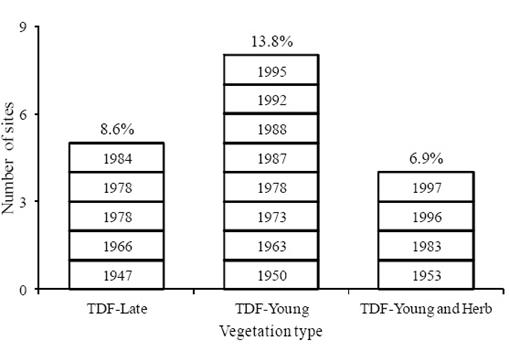
Figure 7 Types of plant cover in lands received by families in Zoyatlan according to the surveys. Above bars percentage: proportion of land with tropical deciduous forest (TDF) late, young and herbaceous vegetation. Inside bars: year lands obtained.
It is thus evident that the degraded state of the TDF in 1998 is not a result of the productive activities carried out by FUs since 1947 or the population growth seen in Zoyatlan starting in 1960 (Figure 6). Results point to social and economic factors and the certainty of land ownership interacting with ecological factors that favor vegetation recovery. The reestablishment of traditional approaches to land management in Zoyatlan contributed to the regeneration of vegetation in areas less suitable for agriculture. Therefore, the different TDF stages are mostly distributed along steep slopes and summits (Figure 4). This phenomenon is not exclusive to Zoyatlan; in Mexico, both the distribution and state of conservation of TDFs are concentrated in areas less suitable for productive use (Trejo and Dirzo, 2000).
Due to the ancestral use of the SES, any fragment of primary TDF is unlikely. However, the different stages of vegetation found in 65% of the territory point to the resilience that set TDF ecosystems apart in terms of their structure and function (Murphy and Lugo, 1986; Brown and Lugo, 1990). Despite the variety of disturbances occurring in Zoyatlan, these properties have helped to maintain a floristic composition currently expressed in taxonomical groups-64 families, 170 genera, 184 species (Figure 5)-which are cited for other TDF regions of Mexico (Trejo and Dirzo, 2002; Pineda et al., 2007; Ávila, 2010).
It should be recognized, however, that the vegetation in Zoyatlan is impoverished due to the predominance of the TDF shrub vegetation. While different factors have contributed to this process, the impoverishment may also be influenced by characteristics inherent to the species. In vegetation fragments with moderately preserved TDF, tree species are subject to certain conditions that limit their frequency and abundance in the landscape: a scarcity of reproductive individuals, gravity-based propagule dispersal mechanisms and the ecological longevity of incipient seeds. This contributes to the fact that the regeneration process in Zoyatlan is controlled by species whose colonization habits are more aggressive, where goats are a significant dispersal agent (Cervantes, 2005).
Application of Restoration Strategies
The information provided by the different diagnostic stages shows that the SES has been subjected to chronic disturbance, in the form of organized land usufruct practices to assure the population's subsistence. These practices, combined with the agrarian conflicts of the early 20th century, brought about an imbalance in the preexisting order and in the ancestral practices in the use and management of the SES; these modifications contributed to degradation of the abiotic and biotic components and thus to weakening the soil and vegetation dynamics.
Table 4 Environmental characteristics of lands (I) and species used (II) in agroforestry systems (AFSs) and plantations established between 1996 and 1999 in Zoyatlan (Guerrero, Mexico).
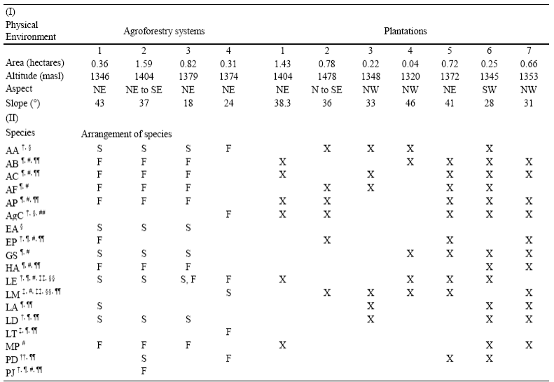
Species names abbreviated with the first letter of the genus name and species, according to Table 5. Arrangement of species in AFS's: F = living fence, S = strips on land. † Sparsely represented and ‡ recovered species. Uses § flowers-human food (HF), ¶ firewood, # fodder, †† fruit-HF, ‡‡ young leaves-HF, §§ seeds-Hf, ¶¶ wood, ## stem-beverage.
Zoyatlan's current dynamics and its socio-cultural and productive value point to rehabilitation as a promising restoration strategy, as it does not include biotic integrity but highlights reparation of the ecosystem's processes, productivity and services for human well-being (Clewell and Aronson, 2008). In Zoyatlan, the need to act in this direction is seen partly in the varying soil organic matter content (Figure 3), its relationship with the set of variables determining fertility and the risk of erosion, pointing to the importance of actions aimed at preventing biological soil degradation. Firewood demand is another issue to consider in these strategies, not only in regard to the vegetation and its degenerative effects on the SES, but also in regard to strengthening the town's energy supply.
The ongoing discussion with residents of Zoyatlan enabled us to collectively define the goals of the strategy: to maintain and recover environmental regulation and supply services by preventing soil degradation and improving the structure and composition of vegetation, in order to strengthen regeneration dynamics. With this purpose, agroforestry systems (AFSs) were established on farmlands as a preventive measure, while plantations (PLs) were set up on lands no longer used to grow crops as a corrective measure.
With information from the vegetation studies regarding species distribution and FUs' preferences based on the usefulness of the species, we designed the structure and composition of each practice, by specific plot of land. This included species that were common in Zoyatlan as remembered by key informants, even if the species were not recorded or were found to be scarce in the vegetation studies (Table 4).
Since government nurseries do not produce native TDF plant species (Cervantes et al., 1996a, Cervantes et al., 2008), and as information on the propagation of these species is very sparse (Bonfil and Trejo, 2010), it was necessary to produce them at the Zoyatlan nursery in order to establish AFSs and PLs. This led to the production of 21 plant species with the proper quality and in sufficient quantity (Table 5), to counter the scarcity of propagules of several species, and to the use of the region's native TDF genetic material, potentially adapted to the environmental conditions of the worksite.
Table 5 Summary results of species germination and growth studies for propagation in nursery.
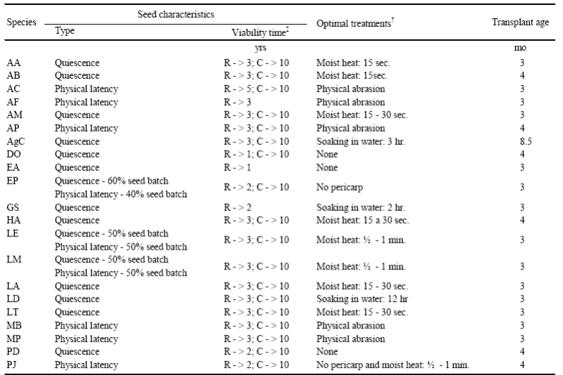
† Considers the capacity, homogeneity and germination rate for different seed batches per species; ‡ ex situ conservation in rustic (R) and controlled (C) storage, years are with respect to the follow-up in nursery and laboratory conditions. AA = Acacia acatlensis, AB = A. bilimekii, AC = A. cochliacantha, AF = A. farnesiana, AM = A. macilenta, AP = A. pennatula, AgC = Agave cupreata, DO = Diphysa occidentalis, Ea = Erythrinaamericana, EP = Eysenhardtia polystachya, GS = Gliricida sepium, HA = Havardia acatlensis, LE = leucaena esculenta, LM = L. Macrophylla, LA = Lysiloma acapulcense, LD = L. divaricate, LT = L.tergemina, MB = Mimosa benthamii, MP = Mimosa polyantha, PD = Pithecellobium dulce, PJ = Prosopis juliflora.
FUs planted their lands from 1996 to 1999; the experience of this process highlighted the importance of incorporating criteria regarding the availability of the FU workforce with respect to its aging and migration, as well as foreseeing risks when activities are carried out in areas where agrarian conflicts persist. These issues, though not environmental in nature, have considerable effect on the development of rehabilitation practices. Technical assessment of AFS and PL impact showed that, despite the variance found among plantation sites in terms of plant survival and growth, overall survival in 2001 was ≥ 48% and plant growth has been successful as all species had considerable size increases as shown in an evaluation conducted in 2013 (Figure 8a, b, c, d). Our ongoing assessment shows that, of the 14 plots set up with rehabilitation actions, only two were abandoned due to agrarian conflict issues. Another aspect of interest is that all species introduced in the ASFs and PLs have reached their reproductive stage, and their contributions of seed are helping to enrich the composition of the soil's seed bank and possibly enhancing the regeneration of vegetation.
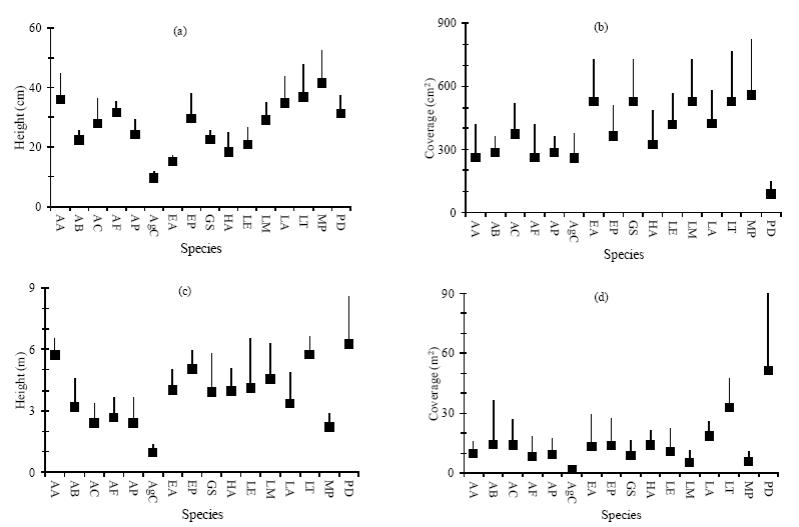
Figure 8 Height and cover (average ± 1 STD) of species used in rehabilitation actions in Zoyatlan (Guerrero, Mexico). Height: (a) initial and (c) current. Cover: (b) initial and (d) current. Initial = size of the plants in the nursery according to Table 5 (optimal age for planting); current = size of the plants in 2013 in the sites with ASFs and PL. AA = Acacia acatlensis, AB = A. bilimekii, AC = A. cochliacantha, AF = A. farnesiana, AP = A. pennatula, AgC = Agave cupreata, EA = Erythrina americana, EP = Eysenhardtia polystachya, GS = Gliricidia sepium, HA = Havardia acatlensis, LE = Leucaena esculenta, LM = L. macrophylla, LA = Lysiloma acapulcense, LT = L. tergemina, MP = Mimosa polyantha, PD = Pithecellobium dulce.
Although the impact of rehabilitation practices on soil characteristics was assessed only at one five-year-old AFS, results suggest improved fertility reflected in increased CEC values and OM content, as well as improved soil physical properties from formation of aggregates that help buffer the risk of soil erosion (Hernández-Cruz, 2014). Due to the steep slopes found on the plots (Table 4), it is important to consider that plants on ASFs and PLs currently provide cover (Figure 8) and a leaf litter layer substantially thicker than that found when the studies were conducted, in 2001. It would therefore be expected that the processes that contribute to preventing erosion also foster microbiological dynamics and improved physical and chemical characteristics of the soils strengthened thereby.
While families in Zoyatlan do not receive any type of support to maintain the rehabilitation practices, the process of appropriation of their resources is underway. FUs currently obtain several goods (Table 4), which the families consume and sell in the local market. These benefits should be analyzed taking into account the physical and economic efforts invested in maintaining the ASFs and PLs, to assist in the appropriation of restoration strategies. The performance of this analysis will generate information to build indicators for restoration processes and ultimately influence public policies aimed at recovering and maintaining the ecological and cultural heritage offered by TDF ecosystems.
Conclusions
The systemic and interdisciplinary approach used in the diagnosis of the Zoyatlan SES provided indispensable insight for undertaking restoration actions with a greater chance of success. The genealogical survey adapted for the purposes of this research provided synchronic and diachronic information on the process of appropriating natural resources in Zoyatlan. An understanding of the current status of the SESs and identification of the disturbance factors contributing to their condition enabled determination of inconsistencies existing in the soil and vegetation components and of their repercussions in the overall behavior of the SES, which guided rehabilitation actions to solve the problems found. Comprehension of the forms of appropriation of the territory and their value in productive and social use enabled the design and implementation of restoration strategies consistent with families' needs and the particular issues of land ownership.
Most FUs have maintained rehabilitation practices, and more than a decade after establishing these practices they have benefited from products for their own use and for selling in local markets. The ongoing involvement of residents in the process points to their need and interest in recovering and maintaining the environmental services on which their subsistence depends. The rehabilitation practices have contributed to halting vegetation impoverishment. In the plots, vegetation composition and structure that previously did not exist or were very poorly developed were reestablished. The plant cover currently growing on plots protects soil from erosion and promises to improve plot productivity.
Despite these achievements, we still cannot say that the different processes involved in maintaining the plant dynamics are reestablished and that the functions that depend on environmental regulation and supply services are set and will remain so accordingly. To make such an assertion, the vegetation currently found on plots with rehabilitation practices need to be assessed, in addition to corroborating their impact on soil improvement. We are also unaware of how families have maintained and modified these practices, or if they will be abandoned if expectations are not met. Its economically precarious position, the agrarian conflicts that still persist in certain areas of Zoyatlan and the migration of younger generations are variables that interact with the current conditions of rehabilitated areas, and will influence their future consolidation.
Given these questions, it is important to complete the process of evaluating the restoration activities, including use of ecological and socioeconomic instruments. The adaptation of rehabilitation practices to assist in their appropriation will depend on the results of this last stage which will contribute to building indicators to enable quantification of environmental and socioeconomic impacts of restoration projects in SES.
Historically, TDFs in Mexico and Latin America have been linked with manipulations by indigenous groups and peasant farmers. The Zoyatlan experience may be used as an example of the possibilities of intervention for recovering and maintaining environmental services in SESs.

