


 texto em
  Inglês (pdf)
 Artigo em XML
 Referências do artigo
 Enviar este artigo por email
 Citado por SciELO
  Similares em
SciELO
Similares em
SciELO 
 Permalink
Introduction
The International Union for the Conservation of Nature (IUCN) enlisted the West Indian manatee (Trichechus manatus) as a vulnerable species because of the historic reduction of its populations and current threats (Deutsch et al. 2008). Moreover, the Antillean subspecies (Trichechus manatus manatus) is considered endangered (Self-Sullivan and Mignucci-Giannoni 2008). This subspecies is found from Mexico to Brazil, including the Greater Antilles and Trinidad and Tobago (Lefebvre et al. 2001). It primarily inhabits turbid and structurally complex freshwater environments (Marsh et al. 2012), where abundance estimation is precluded.
The typical methods for counting manatees are boat and aerial surveys (Aragones et al. 2012, Reynolds et al. 2012). These methods yield uncertain results in turbid or dark water. A novel method to detect and count manatees in these environments is using small side-scan sonar devices (Gonzalez-Socoloske et al. 2009). Side-scan sonar is an efficient tool to detect manatees as far as 30 m from each side of the boat, depending on bottom type, width of waterways, depth, and presence of other fauna (Gonzalez-Socoloske et al. 2009, Gonzalez-Socoloske and Olivera-Gómez 2012).
In the coastal plains of the southern Gulf of Mexico, large rivers form extensive wetland areas with a seasonal flood-pulse dynamics (Moreno-Casasola et al. 2012). One of the largest manatee populations in Mexico inhabits these shallow riverine environments (Marsh et al. 2012), but quantitative assessments have not been made in this area, only in Quintana Roo (Morales-Vela et al. 2000). All the information we have about manatees in the Gulf of Mexico comes from interviews, strandings, and opportunistic sightings of this species (Colmenero and Hoz 1986, Arriaga and Contreras 1993), or from recent studies in particular areas (Pablo-Rodríguez and Olivera-Gómez 2012, Jiménez-Domínguez and Olivera-Gómez 2014).
The coastal plain region of the state of Tabasco is a manatee hotspot in the southern Gulf of Mexico (Colmenero and Hoz 1986, Arriaga and Contreras 1993). However, current threats for the species are increasing and are linked to development pressure of several human activities and industries, including oil and gas extraction. Tabasco is one of the states with the most extensive onshore oil fields in Mexico (INEGI 2011). The Pantanos de Centla Biosphere Reserve (PCBR) is a large wetland protection area in Mexico and is thought to play an important role in the conservation of many plant and animal species, the manatee being one of them (INE 2000), but its real contribution is unknown. The objective of this study was to survey the relative abundance of manatees at selected sites inside PCBR and other reference sites outside the reserve, to visualize spatial patterns in abundance, and to start a regional long-term monitoring of the species. In this survey we used side-scan sonar units and followed standardized procedures.
Material and methods
Study area
This study was conducted within PCBR (17°57'53" to 18°39'03" N, 92°06'49" to 92°47'58" W) and at 2 reference sites, one to the northeast (18°22' to 18°24'22" N, 92°55' to 92°59'30" W) and the other to the southeast (17°46'30" to 17°45'45" N, 91°25'30" to 91°21' W) of this reserve. PCBR extends over parts of the municipalities of Centla, Jonuta, and Macuspana in Tabasco, and over a portion of Palizada in southern Campeche (Fig. 1), covering an area of 302,706 ha (CONANP 2001). The northwestern and northeastern limits of PCBR are the city of Frontera and the Gulf of Mexico at the mouth of the San Pedro/San Pablo River, respectively. The southern limit of PCBR is the Bitzales River (Romero et al. 2000).

Figure 1 Study area in the central and eastern portions of Tabasco, Mexico. The continuous bold line indicates the limits of the Pantanos de Centla Biosphere Reserve. Small boxes indicate the sites sampled in this study (2012-2013): (A) El Coco, (B) Tabasquillo, (D) San José, (E) Bitzales, (F) González, and (H) San Pedro. Sites C and G were initially sampled but excluded because their depth profiles were not comparable with the other sites.
PCBR is located in the "Southern Gulf Coastal Plain" physiographic province and in the "Plains and Swamps of Tabasco" subprovince. The altitude in the terrain varies from -1 to 7 m above mean sea level (INE 2000). Climate is sub-humid with summer rains, annual average temperature of 25 °C, and annual rainfall of 1,600 mm. Four geomorphic systems of plains can be found in PCBR: alluvial, marsh-freshwater lake, coastal barrier, and lagoon (Romero et al. 2000). Hydrophilic plant communities dominate the ecosystems in PCBR, together with tropical semi-deciduous forest dominated by Bucidas bucera L, low evergreen forest of Haematoxylum campechianum, bushes of Dalbergia brownei, palm communities of Acoelorraphe wrightii and Sabal mexicana, and mangrove forest (Guadarrama-Olivera and Ortiz-Gil 2000, Zenteno et al 2010). The more coastal sites may have patches of Vallisneria americana (Novelo and Ramos 2005). Several main rivers flow through the reserve (Grijalva, Usumacinta, Palizada, San Pedro/San Pablo, and Bitzales), as well as several secondary rivers (Chilapa, Puxcatán, Naranjos, and Palomillal) and many other smaller streams and channels, most of them artificial for access to oil extraction facilities. In total, 925 km are covered by rivers. The lentic systems comprise about 110 freshwater lakes that cover an area of 13,665 ha, mainly in the central and southern areas where 84% are located.
These rivers are avenues for manatee movements among sites. The intensity of manatee movements in this region is still unknown, but the sites we chose for this study are associated with lake systems that could promote the temporal establishment of manatees, precluding high rates of movement among sites. Manatees can presumably move from sites all year round but connection among sites is more probable during the rainy months due to higher water level along water courses.
The 2 reference sites outside PCBR are a segment of the González River and a site at the confluence of the San Pedro and Usumacinta Rivers. Both sites are waterways used mainly by artisanal fishermen to travel among towns. Human population is higher in the González River area but terrestrial roads are well established and boat travel is not heavy.
Boat surveys and detection method
From August to December 2012 and from February to June 2013 we surveyed 4 sites within PCBR (El Coco, Tabasquillo, San José, and Bitzales) and 2 reference sites outside the reserve (González River and San Pedro River). The distance between sites ensured low probability of the short-term movement of manatees from one site to another, except between El Coco and Tabasquillo, separated by 14 km. Reference sites were included to determine the relative importance of PCBR with respect to other adjacent areas, which are not under any protected status, where a high frequency of manatee sightings has been reported (Colmenero and Hoz 1986, Arriaga and Contreras 1993), especially in southeastern Tabasco. We conducted surveys between 10:00 and 15:00 h on an 8-m-long boat, powered by a 15-25 HP outboard engine, along a segment of 10 km of waterways. Boat speed was 7.5-10.0 km/h. Selected waterways were <70 m wide and 2 to 5 m deep. We conducted 5 to 7 boat surveys per site. To detect manatees we used a Humminbird 687c SI or 898c SI side-scan sonar unit (Eufraula, AL, USA). The detection width of the sonar was set to 20 m on each side of the boat, and all manatees detected by the sonar were counted. The crew consisted of 2 sonar operators and 1 visual observer. When the sonar operators registered a manatee we repeatedly passed over the location to confirm it. As confirmation criteria we used visual contact at the surface or changes in orientation or position of the object sighted on the sonar screen. Screen capture was recorded for each sighting for posterior examination.
Correction factor
Because of the small number of counts recorded at most sites, we opportunistically used the visit with the highest number of manatees to compute a correction factor, which was not applied to counts but as an indicator of the fraction of manatees not counted due to perception bias. In March 2013, we found a group of 23 manatees in Bitzales River at a point outside the established segment. To estimate a correction factor, we passed 12 times over a 3-km segment (where the 23 manatees were dispersed), recording repeated counts. We used 2 independent sonar units mounted on the same boat. Each sonar operator registered the minute and second of each sighting. Sonar operators had similar experience in manatee discrimination and more than 50 h of training. With these data we estimated a correction factor (CF) based on perception bias using the Petersen mark-recapture procedure, following Marsh and Sinclair (1989), using the next formulae:
where S 1 and S 2 are the number of sighting made by either the first or the second counter, b is the number of sightings made by both counters, and CV is the coefficient of variation.
Statistical analysis
We computed relative abundance as number of manatees in a 10-km segment. Differences in relative abundance among sites were analyzed using the Kruskal-Wallis test, followed by a post hoc analysis (Siegel and Castellan 1995). For descriptive purposes, the distribution of counts for each site was estimated generating 10,000 bootstrap samples from observed data (Good 2006). Statistical analyses were performed in R v3.01 (2013, R Foundation for Statistical Computing).
Results
The relative abundance of manatees at the different sites varied from 0 to 10 manatees in a 10-km transect (Table 1, Fig. 2). We registered low counts at sites in the northern portion of the reserve (sites A and B in Figs. 1 and 3) and higher counts in the southern part (sites D and E in Figs. 1 and 3). The sites outside the reserve (sites F and H in Figs. 1 and 3) showed the same pattern. We found differences in relative abundance among sites (Kruskal-Wallis W = 14.53, d.f. = 5, P = 0.012). The post hoc analysis showed 3 groups of sites (Fig. 3). The site with highest relative abundance was Bitzales (mean and standard error of 5.17 ± 1.9 manatees/ 10 km); at this site we sighted another 27 manatees outside the established segment. However, Bitzales was not statistically different from San Pedro and San José and even from El Coco. The abundance was similar at San Pedro and San José (2.4 ± 0.75 and 2.0 ± 0.68 manatees/10 km) and lower at El Coco (1.4 ± 0.40 manatees/10 km). Tabasquillo and González differed from the rest of the sites, except in the case of El Coco and Tabasquillo. Tabasquillo and González were characterized by low relative abundance (lower than 1 manatee/10 km). The estimated mean correction factor was 1.2 ± 0.17. The coefficient of variation of the correction factor had a mean of 0.21 ± 0.03.
Table 1 Number of surveys (n) and number of manatees detected by side-scan sonar in 10-km segments along selected waterways within and outside the Pantanos de Centla Biosphere Reserve, Tabasco, Mexico (2012-2013).

* Another 27 manatees were sighted outside the established segments; they were not used in the analysis.
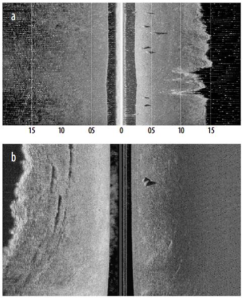
Figure 2 Example of side-scan sonar images. (a) Fragment of a video with several manatees recorded in Bitzales. (b) Screenshot of mother and calf sighted in San Pedro.
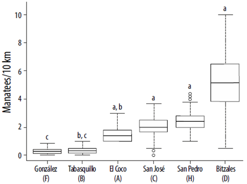
Figure 3 Distribution of manatees counted at each site surveyed in the central and eastern portions of Tabasco, Mexico (median, inter-quartile range, and range; all estimated using 10,000 bootstrap samples). Sites A to D are within the Pantanos de Centla Biosphere Reserve; F and H are reference sites to the northwest and southeast of the reserve. Lower-case letters indicate statistical groups after a post hoc analysis.
Discussion
González, Tabasquillo, and El Coco, the most coastal sites, had low relative abundance, which coincides with the occasional manatee occurrence reported by Colmenero and Hoz (1986). González River, located outside PCRB, is the most coastal location of this study. Previous studies considered this site to be an area with occasional manatee presence (Colmenero and Hoz 1986) and an area with potentially high abundance due to habitat characteristics (Arriaga and Contreras 1993). Manatee abundance was lowest at this site, but local fishermen reported seeing manatees several times during the study period; however, they saw them in the main river and not in the secondary waterways we surveyed. In the case of Tabasquillo, results from interviews (Arriaga and Contreras 1993) indicated a high abundance, contrasting with our results. During the last decade, this last watercourse has suffered modifications related to the prevention of seasonal floods upriver, which may have influenced manatees to move to other areas; however, we sampled just a small portion of this watercourse. Despite our low counts at El Coco, we found manatees in all surveys. The interviews conducted by Arriaga and Contreras (1993) could reflect a high frequency of sightings instead of a high abundance.
In San José we recorded a higher number of sightings compared to sites further north, and Bitzales River was the site with the highest abundance; this represents an increase in abundance towards the south in the PCBR. Although previous interview-based studies reported the presence of manatees in the southern part of the reserve (Colmenero and Hoz 1986, Arriaga and Contreras 1993), there is no mention of a high abundance in this zone. In San Pedro we registered abundances comparable with those of San José and Bitzales. Several important areas for manatee distribution have been reported to the south of the reserve (Alvarez et al. 1988, Colmenero and Hoz 1986, Rodas-Trejo et al. 2008).
The complexity of freshwater systems is important for the presence and abundance of manatees in the area, providing different habitat characteristics and conditions. Medium-size lagoons and intricate channels assure calm water and vegetation. In Belize, Auil (2004) found manatees inland in streams that connect to lakes. In Bitzales, the manatees sighted outside the transects were in a confluence of a channel that connects to a lagoon. Jiménez (2005) and Jiménez-Domínguez and Olivera-Gómez (2014) highlighted confluences as features related to a higher presence and abundance of manatees.
We recorded manatees at all the sampled sites, confirming their regional presence as reported by Colmenero and Hoz (1986). Compared with other deltaic systems in the southern Gulf of Mexico, like the Alvarado Lagoon System in Veracruz (Daniel-Rentería et al. 2012), the study area represents an important manatee hotspot. Based on our results, PCBR is strategically located in the region; therefore, it plays an important role in manatee conservation in Mexico. A corridor should be established beyond the southern limit of the reserve to protect manatees.
Side-scan sonar is a promising tool for monitoring manatees in the southern Gulf of Mexico where water conditions preclude the use of aerial surveys or visual boat surveys. In our study we missed about 20% of manatees available for counting. Standardizing procedures among sites and areas will provide spatial distribution data on which to base conservation strategies. This sonar has been used in Mexico and abroad, but a lack of standardized procedures hinders comparisons among studies. For example, Pérez-Garduza (2013) estimated a higher density of manatees in Laguna de las Ilusiones, Tabasco, than that found in our study, but his transects were shorter (1.9 km) in a lake with a landlocked population of more than 20 animals. Moreover, the behavior of manatees changed in open areas compared to tight watercourses; manatees moved away from the transect instead of remaining at the bottom, which changed the estimated width of the transect surveyed. Likewise, Arévalo-González et al. (2014) surveyed a short transect over a small area with a dense number of manatees, which precludes comparison. Other studies have used sonar for the nonsystematic search of manatees with the goal of exploring new areas and not with the objective of comparing with other surveys (Brice 2014, Daniel-Rentería et al. 2012, Rodas-Trejo et al. 2008).
Factors like the presence of other large animals (e.g., crocodiles, sharks or large fish) could yield misleading counts, so it is important to evaluate if they are common in the area. While not the case in our study area, other vertebrates with important acoustic behaviors, like pinnipeds and cetaceans (Hastiea et al. 2013), may be disturbed by this method and the side-scan sonar should be used with care. Bottom type may also produce a higher perception bias in the case of large coverage of rocks or submerged vegetation; previous exploration of the area is important before considering the use of sonar.

