


Servicios Personalizados
Revista
Articulo
 Inglés (pdf)
 Artículo en XML
 Referencias del artículo
 Enviar artículo por email
Indicadores
-
 Citado por SciELO
 -
 Accesos
Links relacionados
-
 Similares en
SciELO
Similares en
SciELO
Compartir

 Permalink
Ciencias marinas
versión impresa ISSN 0185-3880
Cienc. mar vol.39 no.4 Ensenada dic. 2013
Seasonal morphodynamic classification of beaches in Necochea municipality, Buenos Aires Province, Argentina
Clasificación morfodinámica estacional de playas del partido de Necochea, provincia de Buenos Aires, Argentina
Alejandra Merlotto1,2*, Germán Ricardo Bértola1,2, María Cintia Piccolo3,4
1 Instituto de Investigaciones Marinas y Costeras, Consejo Nacional de Investigaciones Científicas y Técnicas (CONICET).* Corresponding author. E-mail: amerlott@mdp.edu.ar.
2 Instituto de Geología de Costas y del Cuaternario, Universidad Nacional de Mar del Plata. CC 722-Correo Central (7600) Mar del Plata, Argentina.
3 Instituto Argentino de Oceanografía (IADO-CONICET). CC 804 Florida 8000 (Camino La Carrindanga km 7.5), Edificio E1 (B8000FWB), Bahía Blanca, Argentina.
4 Departamento de Geografía y Turismo, Universidad Nacional del Sur, Bahía Blanca, Argentina.
Received August 2012,
received in revised form July 2013,
accepted August 2013.
ABSTRACT
The seasonal morphodynamic classification of Necochea and Quequén beaches (Buenos Aires Province, Argentina) was determined. Based on 102 seasonal beach profiles and sediment sampling between February 2006 and December 2009, variations in morphology and sediment budgets of five beaches were studied. According to the dimensionless fall parameter and the relative tide range, the beaches were classified depending on their modal morphodynamic state. In Quequén, beaches presented intermediate and reflective states, whereas in Necochea they presented dissipative states. The Iribarren number showed that plunging and spilling breakers predominated in Quequén and Necochea, respectively. In winter, the beaches became more dissipative, while in summer-autumn they were more reflective. This general behavior agrees with the erosion/accretion cycles. Beach profile variability was higher in Quequén. These results have been used to elaborate the coastal management program of the area.
Key words: morphodynamics, beaches, coastal erosion, Necochea, Quequén.
RESUMEN
Se realizó la clasificación morfodinámica estacional de playas de Necochea y Quequén (provincia de Buenos Aires, Argentina). Se analizaron la morfología y las variaciones sedimentarias de cinco playas a partir de 102 perfiles topográficos estacionales y muestreos de sedimentos realizados entre febrero de 2006 y diciembre de 2009. Mediante el parámetro adimensional de asentamiento y la amplitud relativa de mareas, las playas fueron clasificadas de acuerdo con su estado morfodinámico predominante. En las playas de Quequén prevalecieron los estados morfodinámicos intermedios y reflectivos, mientras que en las de Necochea prevaleció el estado disipativo. De acuerdo con el número de Iribarren, el tipo de rompiente predominante fue en voluta en Quequén y en derrame en Necochea. Durante el invierno, todas las playas presentaron un estado más disipativo, mientras que en verano y otoño un estado más reflectivo, en concordancia con los ciclos de erosión/acreción. Las playas con mayor variabilidad morfodinámica fueron las de Quequén. Estos resultados han sido empleados en la elaboración del plan de manejo costero del área estudiada.
Palabras clave: morfodinámica, playas, erosión costera, Necochea, Quequén.
INTRODUCTION
Port construction, economic activities (industry, tourism, etc.), the expansion of cities and increase in urban waste, among other causes, have contributed to the degradation of coastal environments (Merlotto and Bértola 2009, Xue et al. 2009, Komar 2010). Moreover, coastal areas are particularly vulnerable to the effects of climate change, such as rising sea level and the intensification of storms (Regnauld et al. 2004, Fiore et al. 2009). In this sense, studies on beach evolution and behavior constitute a basic tool for appropriate urban planning and integrated coastal management.
The morphodynamic state of a beach mainly depends on the characteristics of the sediments and the incident wave climate (Wright and Short 1984). Given the complex relationships between beach processes and elements, the study of beach morphodynamics contributes to the understanding of coastal environments and their variability (Benedet et al.. This information is obtained by periodically monitoring beach morphology, sediments, and wave-induced changes (Benavente et al. 2002). The most commonly used beach classification methods worldwide (Short 1996, Benedet et al. 2004, Anfuso et al. 2006, Gómez-Pujol et al. 2007, Qi et al. 2010) are the model proposed by Wright and Short (1984) to determine beach morphodynamic states, the inclusion of the effect of tidal range to this model as proposed by Masselink and Short (1993), and the surf similarity parameter or Iribarren number proposed by Battjes in 1974 (Masselink and Hughes 2003).
Wright and Short (1984) identified six types of beaches with different morphologies and behaviors based on the dimensionless fall velocity (Ω). Reflective beaches (Ω < 1.5) form during low-energy wave conditions, in protected areas, and have coarse sand; the foreshore is usually uniform and steep, and waves break by surging or collapsing. Dissipative beaches (Ω > 6) are flat and have a soft slope, fine or medium sand, and high spilling breakers; the surf zone is wide and can have several bars. Between the reflective and dissipative morphodynamic states there are four types of intermediate beaches. These beaches have fine to medium sands, one to two bars, a backshore with moderate morphological changes, and waves of average height. The intermediate beach states are called low tide terrace (Ω ≈ 2), transverse bar and rip (Ω≈), rhythmic bar and beach (Ω ≈ 4), and longshore bar and trough (Ω ≈ 5). After introducing the effect of tidal range (relative tide range, RTR) to Ω, Masselink and Short (1993) defined the beach types as reflective beach (Ω < 2; RTR < 3), low tide terrace beach (Ω < 2; 3 < RTR < 15), barred intermediate beach (2 < Ω < 5; RTR < 3), low tide bar/rip intermediate beach (2 < Ω < 5; 3 < RTR < 7), barred dissipative beach (Ω > 5; RTR < 3), and ultra-dissipative beach (Ω > 5; 3 < RTR < 15). The types of breakers are classified according to the Iribarren number (ξ) as spilling (ξ < 0.4), plunging (0.4 < ξ< 2), and surging (ξ > 2) (Masselink and Hughes 2003).
The purpose of classifying beaches according to their morphodynamic state is to provide a conceptual framework for studying and understanding coastal environments. This classification forms the basis for diverse research such as assessing the vulnerability of beaches to coastal phenomena like sea level rise or erosion (Kokot et al. 2004, Boruff et al. 2005) , the effects of storms (Benavente et al. 2002), artificial beach nourishment, and coastal defense structures (Anfuso et al. 1999). In Argentina, few studies have been conducted on the morphodynamic state of beaches and only of some beaches in Buenos Aires Province and Patagonia (Isla et al. 2001, 2002; Bértola 2006). The coastline of Buenos Aires Province has undergone intensive urbanization since 1930 and, consequently, the natural environment has been highly modified (Merlotto and Bértola 2008). In the municipality of Necochea, the cities of Necochea and Quequén (fig. 1) expanded on both sides of the river Quequén Grande after Quequén port was established and its associated agroindustrial activities developed. Commercial and beach-related recreational activities followed and since 1970 the area has become an important tourist destination.
The growth of both urban centers, the creation and forestation of Miguel Lillo Park, and the increase in socioeconomic activities have altered the natural system and generated environmental problems. The construction of the port's two breakwaters at the beginning of the 20th century caused sand erosion in Quequén and sand accumulation in Necochea due to the obstruction of the littoral drift (Perillo et al. 2005). The beaches and coastal infrastructure have suffered varying degrees of damage during storms. In coastal areas where the effects of human intervention are more important, partial post-storm beach recovery can occur and the degree of erosion varies depending on the magnitude of human intervention and beach characteristics. The municipal authorities thus decided to elaborate a coastal management plan. One of the objectives was the implementation of measures to prevent and mitigate the erosion process in order to enable sustainable tourism. For this, greater knowledge of the environment and its components was needed in view of the few studies available on beach evolution and erosion in the study area (Isla et al. 1997, 2009); hence, the objective of this study was to perform a seasonal morphodymic classification of the Necochea and Quequén beaches and analyze their sedimentary variations in order to generate information for the coastal management program.
MATERIALS AND METHODS
Study area
The study area (fig. 1) is located in the Pampean plains of southern Buenos Aires Province. It extends over the Southern Dune Barrier, which consists of extensive dune fields that are totally or partially covered with natural and human-induced vegetation and subject to different levels of urbanization. Active and inactive cliffs as well as abrasion platforms occur along the coast forming mixed landforms such as inactive cliffs with eolian ramps in certain sectors. Sandy beaches unfold almost uninterruptedly.
The coastline has a SW-NE orientation, coinciding with the predominant direction of the littoral drift (Perillo et al. 2005). The tide is mixed, mainly semidiurnal, and mean tidal amplitude is 0.98 m (SHN 2009). Mean wind speed is 17.8 km h-1 and the winds blow predominantly from the N and NW (Merlotto and Piccolo 2009). Highest speeds correspond to winds from the SW and S.
The following five beaches were studied: Costa Bonita and Bahía de los Vientos in the city of Quequén, and Asilo, Kabryl, and Médano Blanco in the city of Necochea (fig. 1). Costa Bonita (fig. 2a) has a mean width of 63 m and a moderate slope (4.8%); it lies between an abrasion platform and a degraded coastal dune, and its natural dynamics have been altered by the presence of two deteriorated groins. Bahía de los Vientos (fig. 2b) is a pocket beach with a mean width of 40 m and a steep slope (7.7%); it lies at the foot of an active cliff and does not present backshore development. Rip-rap defense work was carried out here parallel to the shoreline in 2009. Asilo (fig. 2c) is located in the urban sector of Necochea, 1800 m to the west of the southern breakwater of Quequén port; it is the most extensive beach of the area (278 m) and has the gentlest slopes (2.6%). Kabryl and Médano Blanco are both located in front of Miguel Lillo Park. Kabryl (fig. 2d) has a mean width of 127 m and a moderate slope (3.8%); it lies at the foot of a 4-m-high inactive cliff partially covered by forested dunes and is close to a resort that allows beach vehicle access. Médano Blanco (fig. 2e) has a moderate slope (4.0%) and a mean width of 105 m, and it is located at the foot of a cliff with eolian ramp; a coastal road separates the beach from a vegetated dune field of Miguel Lillo Park.
Fieldwork and analysis
Wave data were obtained from July 2006 to December 2009 by an Interocean S4 AWI current meter equipped with wave sensors. The current meter was located 400 m to the southwest of the Quequén southern breakwater (fig. 1) and is operated by the port authority (Consorcio de Gestión de Puerto Quequén). The data were complemented with direct measurements during the surveys. The sensor measurements (20-min measurement interval) were processed by the Wave program for Windows to obtain maximum, mean, and significant wave height; maximum, mean, and significant period; and propagation direction, among other parameters. Standard statistical methods were then used to obtain mean values. Mean spring tide amplitude was taken from the tide tables of the Naval Hydrographic Service (SHN 2009).
A total of 17 seasonal surveys were conducted between February 2006 and December 2009. At the five beaches surveyed (fig. 1), profiles were established perpendicular to the coastline, measured from a fixed point to approximately 0.50 m below the low water. Elevation was measured every 5 m using a theodolite (Nikon Nt2a) and a graduated rod. At Costa Bonita, three profiles were taken, with a spacing of 100 m, and referred to the zero elevation of the National Geographic Institute (IGN, Argentina). At the other beaches, one profile was taken and when it was not possible to refer it to an IGN elevation, a relative height was attributed. The beach morphology, foreshore slope, and sediment budget were determined from the analysis of the beach profiles.
The foreshore slope (P, %) was calculated based on the following equation:
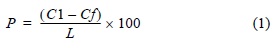
where C1 is the berm crest elevation, Cf is the elevation of the last point of the profile, and L is the distance between both points.
Sediment volumes were calculated using the conventional method proposed by Fox and Davis (1978), which has been widely used in studies of Buenos Aires beaches (e.g., Bértola 2001, Isla et al. 2009). Sand volume was calculated as the area below the profile, from the fixed point to the base level defined by the last profile elevation, considering a lateral continuity of 5 m on both sides of the profile. In most cases, beach profiles of different lengths were compared, so the length of the shortest profile was considered in each comparison. The sediment volume for each topographic profile, the seasonal sediment budget, and the total for the period examined were obtained. The topographic profiles of 21 September 2007 and 18 March 2008 showed morphologies and/or volumetric changes that differed from the average beach profiles. As intense storms occurred before these surveys, during which mean significant wave height was 2-3 m for 6 days, these profiles were analyzed to determine changes induced by storm waves.
Grain settling velocity was obtained by the method proposed by Gibbs et al. (1971), using the mean grain size of each beach surveyed. Surface sediment samples were collected from the foreshore during the surveys between September 2007 and December 2009. Depending on particle size, sifting was done using 12 or 18 sieves (ASTM specifications) at 0.5-phi intervals. Mean grain size and sorting were calculated according to Folk and Ward (1957) using the GRADISTAT program (Blott and Pye 2001).
The classical dimensionless parameters as well as the data obtained from the topographic surveys, sediment samplings, and field measurements were used to classify the beaches according to their morphodynamic state. The predominant wave breaker type was calculated based on ξ:

where tan β is the mean foreshore slope, Hb is the breaker wave height, and Lo is the wave length in deep waters (Masselink and Hughes 2003). Lo was calculated as:

where T is the wave period and g is the acceleration due to gravity.
The following equation was used to obtain Ω (Wright and Short 1984):
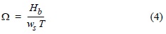
where ws is the grain settling velocity.
The parameter proposed by Masselink and Short (1993) considers Ω and incorporates the relative tide range (RTR):

where MSR is the mean spring tide range.
RESULTS
Wave climate
Wave height showed a seasonal behavior (fig. 3). Mean daily significant wave height was highest (1.26 m) in winter (June to August) and lowest (0.96 m) in summer (December to February). Autumn and spring had the same mean significant wave height (1.18 m).
Wave direction was ESE to SW (fig. 4), with a predominance of waves from the SSE in all seasons. In summer and autumn, the dominant waves were from the SSE (32% and 35%, respectively) and from the S; however, in spring and summer, the predominance of waves from the SSE was more marked (42%) and the frequency of waves from the S decreased. In spring and summer, the dominant waves were from the SE, whereas in autumn and winter the dominant waves were from the SSW. This was related to the greater frequency of winds from the W and SW in autumn and winter and from the E and SE in spring and summer (Merlotto and Piccolo 2009).
Regarding wave height in relation to wave direction (fig. 4), the highest values corresponded to waves from the S and SW in autumn, winter, and summer, and from the SSE in spring. Waves higher than 3 m had a frequency of 9.3% in winter, 5.3% in spring, 4.7% in autumn, and 2.8% in summer. Waves with daily mean significant wave height greater than 4.5 m were recorded in winter and spring (frequencies of 1.6% and 0.5%, respectively), and waves higher than 6 m (0.6%) were only recorded in winter.
Morphosedimentary variations
The beaches on the west and east sides of Quequén port (fig. 1) are composed of sediments of different grain sizes. The Necochea beaches (Asilo, Kabryl, and Médano Blanco) are composed of well-sorted fine sands, whereas the Quequén beaches (Bahía de los Vientos and Costa Bonita) are composed of poorly- or moderately-sorted medium to coarse sands (table 1). Costa Bonita is also composed of fine gravel, constituting a mixed sand and gravel beach. Seasonally, the sediments were finer in winter and spring than in autumn and summer, though at Médano Blanco and Kabryl they were finer in summer than in spring.
By studying sediment volumes and their variations, it is possible to determine the state and evolution of beaches and estimate differences and changes in the sediment supply. Between February 2006 and December 2009, sediment loss occurred in the study area for the most part of each year. The beaches had negative sediment budgets in all the seasons except autumn (table 1), when all of them had positive budgets. The highest sediment losses were recorded at Costa Bonita (-108.9 m3), Asilo (-400 m3), and Kabryl (-254.8 m3) (table 1). Though erosion occurred in winter at Bahía de los Vientos (-208.9 m3) and Médano Blanco (-128.2 m3), the greatest decrease in volume occurred in summer at Bahía de los Vientos (-287.3 m3) and in spring at Médano Blanco (-146.2 m3). At the Quequén beaches, sand recovery occurred only in autumn (Costa Bonita, 157 m3; Bahía de los Vientos, 377.2 m3). At the Necochea beaches, sand recovery occurred in autumn at Médano Blanco; in spring, summer, and autumn at Asilo; and in summer and autumn at Kabryl (table 1). The sediment budget for the whole study period was negative for the two Quequén beaches (Bahía de los Vientos, -47.5 m3; Costa Bonita, -24.1 m3) and for Médano Blanco (-55.9 m3), but positive for the Necochea beaches closest to the port (Asilo, 53.2 m3; Kabryl, 76.8 m3).
The two Quequén beaches had steeper foreshore slopes (fig. 5a-d) than the Necochea beaches (fig. 5e-g). Bahía de los Vientos had the steepest slopes (mean foreshore slope of 7.7%) and Costa Bonita more moderate slopes (4.6%) (table 1). Asilo had the gentlest slopes (2.1%), followed by Kabryl (2.9%) and Médano Blanco (3.2%) (table 1).
The topographic surveys of 21 September 2007 and 18 March 2008 were conducted after intense storm waves (fig. 3) and revealed changes at all five beaches. The winter of 2007 and summer of 2008 were periods of intense beach erosion at all the sites, except in summer at Kabryl, where improvements made to the resort's infrastructure modified the beach profile. One of the most evident morphological changes was observed on 21 September 2007 at Bahía de los Vientos, where a 1.35-m-high escarpment (figs. 2b, 5d) and a slope of 10.5% (from the crest to the end of the profile) were measured after a storm that generated a mean daily significant wave height of 2-3 m for 7 days prior to the survey (fig. 3). Storm waves can also considerably reduce the foreshore slope (fig. 5) due to intensive sediment loss. Such changes were detected after the survey of 18 March 2008 following an 8-day-long event with a mean daily significant wave height of 1.5-2.5 m (fig. 3). At Bahía de los Vientos, for example, the foreshore slope of 4.0% and the topographic beach level were the lowest recorded during the study period (fig. 5d); 703.1 m3 of sand were lost relative to the previous profile.
In addition to the changes mentioned, sediment movement was observed from the berm toward the sea during the September 2007 and March 2008 surveys, in some cases forming a small bar and trough. These geoforms were more apparent at Costa Bonita (fig. 5a-c) and to a lesser extent at Kabryl and Médano Blanco (fig. 5f-g). The changes were less important at Asilo (fig. 5e) and Médano Blanco (fig. 5g).
Morphodynamic classification
According to ξ, spilling breakers predominated throughout the year at the Necochea beaches. At Quequén, plunging waves predominated all year round, except in winter at Costa Bonita, when spilling breakers predominated. The predominant wave breaker type at the beaches is related to the different foreshore slope values and variations throughout the year. Plunging breakers occurred at the beaches with steeper slopes (Quequén beaches). During the surveys, primarily at the Quequén beaches, spilling breakers were observed after the first plunging breaker or between plunging breakers. Plunging breakers were less frequently observed at Kabryl and Médano Blanco. The predominance of one breaker type or another varied depending on sea conditions on the day of the survey.
The seasonal morphodynamic state of the beaches surveyed was established according to the models proposed by Wright and Short (1984) and Masselink and Short (1993). Based on Wright and Short (1984), the predominant morphodynamic state was intermediate at the Quequén beaches and dissipative at the Necochea beaches (table 1). At Costa Bonita (fig. 5a-c), in autumn, spring, and summer the morphodynamic state was intermediate with low tide terrace, with conditions similar to those of the reflective state; in winter the predominant state was intermediate with bar and rip currents. At Bahía de los Vientos (fig. 5d), the intermediate states predominated (table 1). Towards the west, in autumn and spring the predominant morphodynamic state at Asilo (fig. 5e) was dissipative. Kabryl (fig. 5f) was a dissipative beach in winter and, with conditions similar to those of that state, it became an intermediate beach with longitudinal bar and trough in autumn and spring; in summer, the predominant state was intermediate with rhythmic bars (table 1). Médano Blanco (fig. 5g) was a dissipative beach during most of the year except in spring when it became an intermediate beach with longitudinal bar and trough (table 1).
Based on the parameter proposed by Masselink and Short (1993), the intermediate states immediately before the reflective and dissipative states, obtained according to Wright and Short (1984), were observed to become fully reflective or dissipative. Hence, Costa Bonita was a reflective beach in autumn and summer and a barred intermediate beach in winter and spring. Bahía de los Vientos was a barred intermediate beach throughout the year (table 1). The Necochea beaches were barred dissipative except for Kabryl in summer, when it was a barred intermediate beach (table 1). The RTR obtained for the study area was 1.01 and 1.34 for winter and summer, respectively, and 1.09 for autumn and spring; therefore, the effect of tidal range was not significant.
DISCUSSION
The predominant morphodynamic states and sediment variations of the beaches surveyed on both sides of Quequén port differed. At Costa Bonita the predominant morphodynamic state was low tide terrace intermediate, based on Wright and Short (1984), and reflective, based on Masselink and Short (1993). The reflective state develops at beaches composed of coarse to medium sand and protected by groins, such as Costa Bonita. This morphodynamic state was observed at beaches with straight groins in the city of Mar del Plata (Bértola 2006). The dissipative or almost dissipative Necochea beaches characterized by spilling breakers had fine sands, gentle slopes, and wide surf zones. These characteristics have also been observed at dissipative beaches in southeastern Australia and southern Africa (Short 1996). The only other beaches in Buenos Aires Province that present this morphodynamic state are the extensive beaches at Punta Mogotes and the artificially nourished beaches of Mar del Plata (Bértola 2006). Intermediate states occur at beaches with fine to medium sand and plunging and spilling breakers, such as Bahía de los Vientos. These types of beaches are abundant in the eastern part of Buenos Aires Province, to the south of Punta Mogotes and in Miramar (Bértola 2006).
Regarding the seasonal evolution of the morphodynamic states, in winter all the beaches became more dissipative, whereas in summer and autumn they were more more reflective (except Médano Blanco, which was reflective in spring). These results coincide with the morphodynamic behavior described by Masselink and Hughes (2003) and documented for Mexican beaches (Lizárraga-Arciniega et al. 2007). An increase in wave height during winter (1.26 m) favors offshore sediment transport and the beach switches to a dissipative state. Conversely, a decrease in wave height during summer (0.96 m) favors onshore sediment transport, producing a more reflective state (Masselink and Hughes 2003). The storm waves prior to the March 2008 topographic survey caused the beaches to change to a dissipative state (fig. 5).
The response of the beaches surveyed to storm waves can be linked to their predominant morphodynamic state. According to Qi et al. (2010), barred beaches present the most complex behavior and can suffer erosion of the berm and seaward migration of the littoral bar. The post-storm profiles showed an abrupt escarpment and loss of beach elevation at Bahía de los Vientos (fig. 5d), and this beach was the most sensitive to changes in wave energy. Costa Bonita (fig. 5a-c) showed sediment transport from the berm towards the sea, and erosion in the upper part of the beach and accumulation in the lower part. This response is typical of low tide terrace intermediate beaches (Qi et al. 2010). Kabryl showed changes, though not as important as those of the Quequén beaches, whereas Asilo and Médano Blanco had a more stable behavior and weaker response to storm waves, which is characteristic of dissipative beaches (fig. 5e, g) (Qi et al. 2010).
The sediment budgets for the study period (February 2006 to December 2009) revealed an erosive tendency at the two Quequén beaches and the Necochea beach farthest from the port (Médano Blanco), and an accumulative tendency at Asilo and Kabryl. The beach seasonal cycles showed erosion in winter and spring, and accumulation in autumn and summer, concurring with the predominant morphodynamic states. Larson and Kraus (1994) reported that North Carolina beaches had a similar behavior in spring and autumn, with transitional morphodynamic states between the predominant summer and winter cycles. This behavior was observed only at Kabryl. The Quequén beaches, mainly Bahía de los Vientos, showed the greatest changes in beach profile. Anfuso et al. (2006) found that beach profiles taken close to human-made structures showed greater variability. Hill et al. (2004) also observed a differential behavior of beach profiles measured at sites that were located in close proximity to one another but had different degrees of urbanization. The location of the Quequén beaches is unfavorable in relation to the port's breakwaters and the presence of urban centers. As the cities expanded over the dune fields, the beach-dune interaction was modified and beach sediment supply decreased (Merlotto et al. 2012). Because of the direction of the predominant littoral drift (SW-NE) and winds (N-NW) throughout the year, the Quequén beaches were the most affected by the decrease in sediment supply. The influence of these factors is evinced by the positive sediment budgets at the two Necochea beaches closest to the port and the negative budgets at the Quequén beaches.
The findings of this study contribute to understanding the area under study and have been used to develop measures for the prevention, mitigation, and monitoring of coastal erosion by the aforementioned coastal management program. The beaches to the west of Quequén port differed from those to the east. The Necochea beaches were dissipative, whereas the Quequén beaches, located down-drift, presented intermediate and reflective states. Accretion occurred in autumn and, to a lesser extent, in summer. The Quequén beach profiles showed greater variability and more pronounced changes induced by storm waves; however, given the observations on the effect of storms, future studies should consider beach response and recovery, as well as the storm characteristics. Such studies are important in highly-urbanized areas where the beach sediment sources have been modified, since a decline in sediment supply hinders beach recovery after intense storms (Loureiro et al. 2009). Moreover, areas with different tendencies (erosive and accumulative) have been distinguished, and appropriate measures can thus be taken in accordance with the specific needs of each sector. The proper functioning of the coastal management plan and reduction of the erosive phenomenon depends on this.
A convenient measure that should be adopted to prevent and mitigate coastal erosion is to avoid the excessive forestation of coastal dunes because when wind transport is interrupted, the exchange of sand between dunes and beach is affected. Moreover, future fixed coastal structures should be planned and designed considering the littoral drift and not interrupt it. In fact, their use should be discarded and beach regeneration works undertaken instead. It is also necessary to respect the beach profile and avoid levelling and destroying the berm and cleaning with machinery, since the natural geoforms of a beach constitute its defense and maintain its dynamic equilibrium. Finally, beach evolution should be systematically monitored and a plan should be implemented to restore the coastal area. These suggestions will help to prevent sediment loss and allow sediment transport from the west to the east of the study area, where the most affected sites are located. They will also permit the long-term sustainable use of the beaches in an area where tourism has great economic potential.
ACKNOWLEDGMENTS
We thank the municipality of Necochea (Martín Sarasíbar and Gabriel Molina) and Consorcio de Gestión de Puerto Quequén) for the data provided. We also thank the anonymous reviewers for their valuable comments that considerably improved the manuscript.
English translation by Christine Harris.
REFERENCES
Anfuso G, Gracia FJ, Martínez JA, del-Río L, Andrés J, Sánchez F, López-Aguayo F. 1999. Modelización del comportamiento morfodinámico de las playas mediante el estudio de la profundización de removilización. Estud. Geol. 55: 119-125. http://dx.doi.org/10.3989/egeol.99553-4 [ Links ]
Anfuso G, Bello E, Benavente J, Nachite D, Macias A. 2006. Características morfológicas y variabilidad volumétrica de las playas del litoral entre Ceuta y Cabo Negro (Marruecos). Cienc. Mar. 32: 579-588. [ Links ]
Benavente J, del-Río L, Anfuso G, Gracia FJ, Reyes JL. 2002. Utility of morphodynamic characterization in the prediction of beach damage by storms. J. Coast. Res. SI(36): 56-64. [ Links ]
Benedet L, Finkl CW, Campbell T, Klein A. 2004. Predicting the effect of beach nourishment and cross-shore sediment variation on beach morphodynamic assessment. Coast. Eng. 51: 839-861. http://dx.doi.org/10.1016/j.coastaleng.2004.07.012 [ Links ]
Bértola GR. 2001. 21 years of morphological modifications in an urbanized beach (Playa Grande, Mar del Plata, Argentina). Thalassas 17: 21-36. [ Links ]
Bértola GR. 2006. Morfodinámica de playas del sudeste de la provincia de Buenos Aires (1983 a 2004). Lat. Am. J. Sedimentol. Basin Anal. 13: 31-57. [ Links ]
Blott SJ, Pye K. 2001. GRADISTAT: A grain size distribution and statistics package for the analysis of unconsolidated sediments. Earth Surf. Process. Landforms 26: 1237-1248. http://dx.doi.org/10.1002/esp.261 [ Links ]
Boruff BJ, Emrich C, Cutter SL. 2005. Erosion hazard vulnerability of US coastal counties. J. Coast. Res. 21: 932-942. http://dx.doi.org/10.2112/04-0172.1 [ Links ]
Fiore MME, D'Onofrio EE, Pousa JL, Schnack EJ, Bértola GR. 2009. Storm surges and coastal impacts at Mar del Plata, Argentina. Cont. Shelf Res. 29: 1643-1649. http://dx.doi.org/10.1016/j.csr.2009.05.004 [ Links ]
Folk RL, Ward W. 1957. Brazos River bar: A study in the significance of grain size parameters. J. Sediment. Petrol. 27: 3-26. [ Links ]
Fox W, Davis R Jr. 1978. Seasonal variation in beach erosion and sedimentation on the Oregon coast. Geol. Soc. Am. Bull. 89: 1541-1549. [ Links ]
Gibbs RJ, Mathews MD, Link DA. 1971. The relationship between sphere size and settling velocity. J. Sediment. Petrol. 41: 7-18. [ Links ]
Gómez-Pujol L, Orfila A, Cañellas B, Alvarez-Ellacuria A, Méndez FJ, Medina R, Tintoré J. 2007. Morphodynamic classification of sandy beaches in low energetic marine environment. Mar. Geol. 242: 235-246. http://dx.doi.org/10.1016/j.margeo.2007.03.008 [ Links ]
Hill HW, Kelley JT, Belknap DF, Dickson SM. 2004. The effects of storms and storm-generated currents on sand beaches in southern Maine, USA. Mar. Geol. 210: 149-168. http://dx.doi.org/10.1016/j.margeo.2004.05.008 [ Links ]
Isla FI, Farenga MO, Cortizo LC, Bértola GR, Serra SB. 1997. Dinámica morfosedimentaria de playas de arena y grava de la Barrera Austral: Mar del Sud, Arenas Verdes y Costa Bonita. Rev. Asoc. Argent. Sedimentol. 4: 15-24. [ Links ]
Isla FI, Bértola GR, Schnack EJ. 2001. Morfodinámica de playas meso y macromareales de Buenos Aires, Río Negro y Chubut. Rev. Asoc. Argent. Sedimentol. 8: 51-60. [ Links ]
Isla FI, Iantanos N, Estrada E. 2002. Playas reflectivas y disipativas macromareales del Golfo San Jorge, Chubut. Rev. Asoc. Argent. Sedimentol. 9: 155-164. [ Links ]
Isla F, Bértola G, Merlotto A, Ferrante A, Cortizo LC. 2009. Requerimientos y disponibilidad de arenas para la defensa de las playas de Necochea y Lobería. Rev. Asoc. Geol. Argent. 65: 446-456. [ Links ]
Kokot RR, Codignotto JO, Elissondo M. 2004. Vulnerabilidad al ascenso del nivel del mar en la costa de la provincia de Río Negro. Rev. Asoc. Geol. Argent. 59: 477-487. [ Links ]
Komar PD. 2010. Shoreline evolution and management of Hawke's Bay, New Zealand: Tectonics, coastal processes, and human impacts. J. Coast. Res. 26: 143-156. http://dx.doi.org/10.2112/08-1079.1 [ Links ]
Larson M, Kraus NC. 1994. Temporal and spatial scales of beach profile change, Duck, North Carolina. Mar. Geol. 117: 75-94. http://dx.doi.org/10.1016/0025-3227(94)90007-8 [ Links ]
Lizárraga-Arciniega R, Martínez-Díaz de León A, Delgado-González O, Torres CR, Galindo-Bect LA. 2007. Alternation of beach erosion/accreetion cycles related to wave action off Rosarito, Baja California, Mexico. Cienc. Mar. 33: 259-269. [ Links ]
Loureiro C, Ferreira Ó, Cooper JAG. 2009. Contrasting morphological behaviour at embayed beaches in southern Portugal. J. Coast. Res. SI(56): 83-87. [ Links ]
Masselink G, Short AD. 1993. The effect of tide range on beach morphodynamics and morphology: A conceptual beach model. J. Coast. Res. 9: 785-800. [ Links ]
Masselink G, Hughes MG. 2003. Introduction to Coastal Processes and Geomorphology. Oxford Univ. Press, New York, 354 pp. [ Links ]
Merlotto A, Bértola GR. 2008. Evolución urbana y su influencia en la erosión costera en el balneario Parque Mar Chiquita, Argentina. Pap. Geogr. 47-48: 143-158. [ Links ]
Merlotto A, Bértola GR. 2009. Coastline evolution at Balneario Parque Mar Chiquita, Argentina. Cienc. Mar. 35: 271-286. [ Links ]
Merlotto A, Piccolo MC. 2009. Tendencia climática de Necochea-Quequén (1956-2006), Argentina. Invest. Geogr. 50: 143-167. [ Links ]
Merlotto A, Piccolo MC, Bértola GR. 2012. Crecimiento urbano y cambios del uso/cobertura del suelo en las ciudades de Necochea y Quequén, Buenos Aires, Argentina. Rev. Geogr. Norte Gd. 53: 159-176. http://dx.doi.org/10.4067/S0718-34022012000300010 [ Links ]
Perillo GME, Pérez DE, Piccolo MC, Palma ED, Cuadrado DG. 2005. Geomorphologic and physical characteristics of a human impacted estuary: Quequén Grande River Estuary, Argentina. Estuar. Coast. Shelf Sci. 62: 301-312. http://dx.doi.org/10.1016/j.ecss.2004.09.018 [ Links ]
Qi H, Cai F, Lei G, Cao H, Shi F. 2010. The response of three main beach types to tropical storms in South China. Mar. Geol. 275: 244-254. http://dx.doi.org/10.1016/j.margeo.2010.06.005 [ Links ]
Regnauld H, Pirazzoli PA, Morvan G, Ruz M. 2004. Impacts of storms and evolution of the coastline in western France. Mar. Geol. 210: 325-337. http://dx.doi.org/10.1016/j.margeo.2004.05.014 [ Links ]
SHN. 2009. Tablas de Marea. Servicio de Hidrografía Naval. Armada Argentina, Buenos Aires, 643 pp. [ Links ]
Short AD. 1996. The role of wave height, period, slope, tide range and embaymentisation in beach classifications: A review. Rev. Chil. Hist. Nat. 69: 589-604. [ Links ]
Wright LD, Short AD. 1984. Morphodynamic variability of surf zones and beaches: A synthesis. Mar. Geol. 56: 93-118. http://dx.doi.org/10.1016/0025-3227(84)90008-2 [ Links ]
Xue Z, Feng A, Yin P, Xia D. 2009. Coastal erosion induced by human activities: A northwest Bohai Sea case study. J. Coast. Res. 25: 723-733. http://dx.doi.org/10.2112/07-0959.1 [ Links ]

