


Servicios Personalizados
Revista
Articulo
 Inglés (pdf)
 Artículo en XML
 Referencias del artículo
 Enviar artículo por email
Indicadores
-
 Citado por SciELO
 -
 Accesos
Links relacionados
-
 Similares en
SciELO
Similares en
SciELO
Compartir

 Permalink
Ciencias marinas
versión impresa ISSN 0185-3880
Cienc. mar vol.31 no.4 Ensenada dic. 2005
Artículos
Study of the dynamic behaviour of the Sancti Petri Channel, southwest coast of Spain
Estudio del comportamiento dinámico del Caño de Sancti Petri
J. Vidal* and B. Tejedor
Departamento de Física Aplicada Polígono del Río San Pedro s/n Edificio CASEM Puerto Real, Cádiz, Spain. * E-mail: juan.vidal@uca.es
Recibido en julio de 2004;
aceptado en mayo de 2005.
Summary
The dynamic behaviour of the Sancti Petri tidal channel (southwest coast of Spain), which is open at both ends and connected to water bodies with different dynamic characteristics (Atlantic Ocean and Cádiz Bay), is studied herein. This singular estuary is characterized by double inflow-outflow extremes, the tide penetrating almost simultaneously through both ends with a small difference of amplitude. For this study, sea level recordings were obtained from different points throughout the channel and the corresponding harmonic constituents were determined. The results show that the phases of the semidiurnal tides increase from the mouths to a zone located in the vicinity of the channel's halfway point, while their amplitudes increase from the Atlantic Ocean to Cádiz Bay along the channel. A one-dimensional numerical model with geometry that is representative of the channel was used to reproduce the features observed for the semidiurnal and diurnal tidal constituents. The data supplied by the model were verified with values obtained at strategically chosen sites of the inner domain. The model developed may be used for operational predictions of tides in the study area, especially for the ports of Gallineras and Sancti Petri.
Key words: tidal channel, numerical model, double inflow-outflow extremes, Sancti Petri.
Resumen
El canal de marea de Sancti Petri se sitúa en el suroeste de las costas españolas y se encuentra conectado a dos cuerpos de agua con características dinámicas propias (Océano Atlántico y Bahía de Cádiz) a través de sus dos extremos. Es éste un singular estuario, por cuanto la propagación de la marea se produce, casi simultáneamente, desde sus dos desembocaduras, con una pequeña diferencia de amplitud. A partir de los datos experimentales se observa que las amplitudes de las constituyentes semidiurnas aumentan a lo largo del canal desde el extremo más al sur (Océano Atlántico) hasta el extremo que conecta con la Bahía de Cádiz, mientras que las fases de estas constituyentes presentan un máximo en una zona próxima al punto intermedio del canal. A partir de un modelo numérico unidimensional, se estudió la propagación de las principales constituyentes semidiurnas y diurnas de la marea. Los resultados obtenidos mediante los modelos han sido validados con datos experimentales tomados en puntos estratégicos dentro del canal. El modelo desarrollado puede ser utilizado para obtener predicciones de mareas en la zona de estudio, especialmente en los puertos de Gallineras y Sancti Petri.
Palabras clave: canal de mareas, modelo numérico, doble entrada de flujo y reflujo, Sancti Petri.
Introduction
Cádiz Bay is located on the southwest coast of Spain, near latitude 36.5°N. It faces west to the Gulf of Cádiz and is landlocked on its southwestern, southern and eastern margins by the mainland. The bay is subdivided into two basins, a shallower inner bay and a deeper outer bay (fig. 1). It is a water body of reduced depths, in which the movement of the water masses is induced by the effect of the tide that is generated in the ocean and propagates to the interior through the border connecting with the open sea. The tide in Cádiz Bay is semidiurnal, the component of astronomical origin M2 being the most important, with more than 85% of the total tidal energy. It is followed in importance by S2 and then by N2. The contribution to the tidal signal of the diurnal components O1 and K1 is very small. Nevertheless, all of them present a similar behaviour, with a stationary character that causes an increase in the amplitude of the waves from the boundary of connection with the Atlantic Ocean to the eastern end of the inner bay. Alvarez (1999) made a first attempt to represent the tides of this bay, based on a numerical model and a great number of observations. Due to this stationary character in Cádiz Bay, the amplitude of the tide increases from the mouth of the outer bay toward the interior to La Carraca station. La Carraca connects with the Atlantic Ocean through the Sancti Petri channel.
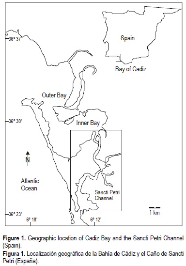
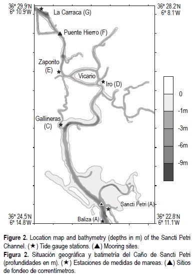
The Sancti Petri tidal channel is an inflow-outflow canal that extends from the inner part of Cádiz Bay to the outlet in the Atlantic Ocean. It is 17 km long and connects to a number of secondary channels that, in turn, supply a vast tidal flat area (fig. 2). This is an important area because of the large population, economical activities (the seaports of Sancti Petri and Gallineras and the military shipyard of La Carraca are located within this tidal channel) and great ecological value. This channel presents a central area of increased depth and shallow areas on both margins, the depth ranging from approximately 9 m in the former to 3 m in the latter. The cross-sectional area of the channel at the mouth decreases as it nears the inside of the channel and the channel bed is covered everywhere with cohesive sediment, mud and clay, with a diameter of less than 50 µm (Gutiérrez et al., 1996).
The problem of tidal propagation in convergent channels has been studied by several authors (e.g., Prandle, 1985; Friedrichs and Aubrey, 1994; Lanzoni and Seminara, 1998). Some studies have investigated the dynamic behaviour of the tides for a channel open at both ends (e.g., Petrie, 1999; Harari and Carmago, 2003). The Sancti Petri Channel, however, is an interesting case because in places it is relatively shallow in comparison with the tidal range and the channel geometry is complex. Experimental data have shown that this channel is a very singular estuary, where the tide penetrates through both extremes with a slight difference in amplitudes and phases (Vidal et al., 2002).
The purpose of this paper is to examine the dynamic behaviour of the amplitudes and phases of M2, S2, N2, K1 and O1, the most prominent semidiurnal and diurnal tidal constituents.
To identify the places that are critical for understanding the observed amplification of the tide in the channel, the next section begins by discussing the experimental data. A numerical model, based on the Abbot-Ionescu type scheme for a branch channel solution algorithm and implemented according to the method of finite difference, was developed. The model results allow for the study of the propagation of the main tidal constituents along the channel, identifying those zones where the amplitudes and phases are maximum. Then, data supplied by the model were verified with values collected at strategically chosen sites of the inner domain.
Experimental data
In order to calculate the boundary conditions and validate the results, sea surface elevation data were measured by sea level recorders (Aanderaa, WLR 7). Using these instruments, a series of elevations of more than one month duration with a cadence of 10 min were obtained. Table 1 shows the sampling period and locations of the moorings. These data were used to determine the main harmonic constants of the tide at different stations throughout the channel (Foreman, 1989). The location of the stations (A-G) can be seen in figure 2.
Off Cádiz Bay (Baliza station), the amplitudes of the semidiurnal constituents are 0.97 m for M2, 0.32 m for S2 and 0.24 m for N2, and those of the diurnal constituents are 0.06 m for K1 and 0.05 m for O1. Within Sancti Petri Channel, the amplitudes of the semidiurnal constituents increase from the mouth to the northern end (inner bay), being 0.10 m for M2, 0.04 m for S2 and 0.03 for N2. The amplitudes of the diurnal constituents are almost uniform along the channel and the total changes in amplitude are 0.01 m (O1 and K1). This analysis allows us to verify that the main tidal component (M2) for the stations located at both ends of the channel (Baliza and La Carraca) are out of phase by 8.7°, which is equivalent to a delay in time of 18 min. For some stations like Zaporito or Iro, the M2 phases are greater than those obtained at Baliza and La Carraca, and similarly for the S2 and N2 phases.
In the case of the diurnal components (O1 and K1), the difference in phases between the two stations located at the ends of the channel is of approximately 24°. The phases for the diurnal constituents increase from the southern end of the channel, in the Atlantic Ocean, to the northern end, in the inner bay, and the maximum value is observed at Zaporito.
At the Sancti Petri (B) and La Carraca (G) stations, a total of three water level records were registered at different seasons of the year, from which the tidal constituents could be calculated. The analysis of these data showed that La Carraca station presents little seasonal variability, unlike Sancti Petri station, where phases show significant variability (Tejedor, 2002). These perturbations can be due to meteorological factors (Tejedor et al., 1997).
The elevation data measured reveal an increase in the phases of the main tidal components from the ends of the channel towards the interior. The physical problem can be exposed as that of two waves, which penetrate the channel almost simultaneously from each end with opposite directions. Therefore, the tide in the Santi Petri channel may be considered to be due to two progressive waves of the same period travelling in opposite directions. One of these is the wave propagating from the open sea; the other is the wave propagating from the inner bay. At Vicario, the two waves are equal in phase. Consequently, a quasi-stationary character of the tide wave is observed in the channel.
Detailed information about the flow is available for the areas of the Sancti Petri and La Carraca stations, which have been investigated systematically by Vidal et al. (2002). Current meter data collected at the two mooring sites were used for the study. The moored current measurements were made at 3 and 5 m depths from the sea surface and 1.5 m above the bottom. These results indicate the following interesting flow features: (a) velocity is uniform over depth (for the purpose of model-observation comparison, currents measured at mid-depth by the current meters were considered to represent depth-averaged currents), and (b) it seems that the M2 semi-minor axes in these regions are very small because the topography strongly constrains the orientation of the tidal currents (the orientation of the principal axes of the current is strongly associated with the orientation of the channel). Therefore, it is a good approach to consider that the flow is one-dimensional.
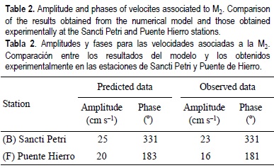
For this study, current velocity data were measured using RCM 7 current meters at stations B and F. Unfortunately, these instruments only allowed us to obtain temporary series of elevations of 10 days duration, and the sampling interval was 10 min. The ellipse parameters are displayed in table 2. The stronger tidal currents occurred at the southern end of the channel, whilst the largest tidal range occurred at the northern end.
According to González-Mazo (1994), salinity stratification is not important because the waters are vertically well-mixed during the whole tidal cycle. The amount of fresh-water runoff inside the channel is insignificant.
Numerical model
The model is solved in one dimension, with the horizontal (x) in the direction of the channel. Let n and Q be, respectively, the perturbation of the upper water surface and water discharge. If we assume that the density of the water is constant, the equation for the conservation of mass and that for momentum can be written as:
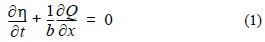
where t, g and K are time, acceleration due to gravity and coefficient of friction, respectively; b(x, t) is the width of the channel at the free surface; A(x, t) is the cross-sectional flow area perpendicular to the flow direction; and h(t, x) is the flow depth. The geometric elements of a section (wetted perimeter, width, hydraulic depth and flow depth) are dependent variables and, therefore, have been recalculated for each temporal step.
In this study, the bottom coefficient was parameterized by the Chezy coefficient:
where n is the Manning roughness coefficient.
The numerical solution by method of finite differences adopted here used the Abbot-Ionescu scheme with branched channel solution algorithms (which includes secondary channels; Abbot, 1979). The upstream open boundary of the channel was located at La Carraca and the downstream boundary at Baliza (fig. 2). The boundary conditions at open sea ends were supplied for the M2, S2, N2, O1 and K1 tidal constituents and obtained initially from data collected. Owing to the seasonal variability of the diurnal constituents, these boundary conditions were the observations of simultaneous registries of the tide at Baliza and La Carraca.
The model estuary consisted of sections distributed along the channel at 75-m intervals. From a series of numerical experiments, a n (Manning) value of 0.04 was found to yield simulated currents that are in close agreement with the observed currents. This value is similar to typical n values (0.033-0.040) (Henderson, 1966). The computing time-step chosen was 5 s and the initial conditions are η(0, x) = 0, Q(0, x) = 0.
For all grid points, the computed time series of surface elevations and currents were analyzed through the harmonic method of tidal analysis (Foreman, 1989).
Results
Semidiurnal constituents
Figure 3(a- (b) c) shows the amplitudes and phases for the semidiurnal constituents (M2, S2 and N2) obtained with the numerical model. The amplitudes of the semidiurnal constituents increase from the southern end of the channel to La Carraca; however, the variations along the channel present three areas of different behaviour: in area I, from Sancti Petri to Gallineras, the rate of change in amplitude (especially of M2 and S2) is almost uniform; in area II, from Gallineras to a point located 11.5 km from the southern mouth (Zaporito), the amplitudes increase strongly; and in area III, from Zaporito to La Carraca, the amplitudes increase very slightly, reaching their maximum value at the end of the channel.
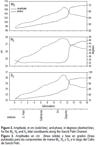
The phases for M2, S2 and N2 increase rapidly near Zaporito (area II), and present maximum values in the proximity of Vicario, approximately 11 km from the southern border. The total change in phase from the southern mouth to the point of maximum phase (Vicario) is 17° (8°, from the northern mouth). The presence of this maximum is due to the convergence of the two waves that propagate from the ends towards the inner channel. This assertion is supported by the fact that the flow changes its orientation 180° at this place (fig. 4a- (b) c).
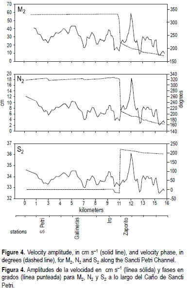
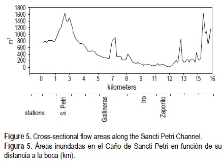
Figure 4 shows the depth-averaged tidal current for the semidiurnal constituents (M2, S2 and N2). These velocities are determined from the flows and channel areas. As the channel presents continuous changes in width, the velocities show great variability. This can be clearly seen in figure 5, where the area of the channel is shown in terms of distance (kilometers).
Diurnal constituents
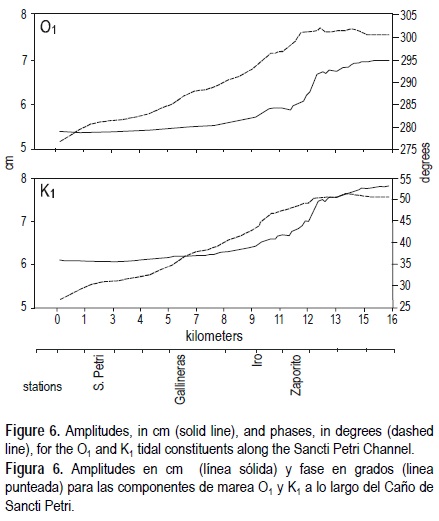
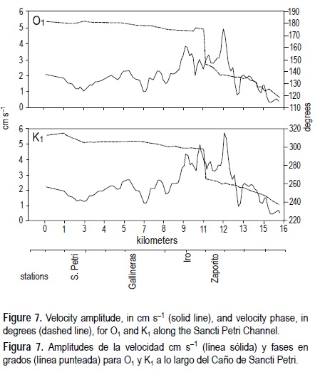
The amplitudes of the diurnal constituents (O1 and K1) increase from Sancti Petri to La Carraca; however, contrary to that found for the semidiurnal components, the maximum values of the phases appear displaced towards the northern end (fig. 6). The total change in phase from the northern mouth to the point of maximum phase is 2° for O1 and 1° for K1. Figure 7 shows the depth-averaged tidal current for the diurnal constituents.
Comparison of the numerical results with observations
The response of the numerical model to real elevations can be compared with the data collected at moored stations in the channel (table 3). Elevation records from four stations (B-E) are used for the validation of our modelling results.
The phases and amplitudes obtained with the model show good agreement with the observations. There is a very slight tendency for the model to over-predict the observed value of the M2 and S2 amplitudes, and the N2 amplitude is significantly over-predicted (4 cm for Sancti Petri and 3 cm for Iro). There is also a slight tendency for the phases of M2 to be smaller than those measured at Zaporito and Iro (2° and 3°, respectively). Discrepancies occur for the phases of S2 and N2 at Sancti Petri; however, the observed data indicate that this station presents an anomalous behaviour. This can be due to meteorological effects, which are particularly important at Sancti Petri station, as shown by the seasonal variability of the data recorded there (Vidal, 2002).
For the diurnal components, table 3 shows a reasonable agreement between the amplitudes and phases for stations B to E, with corresponding values derived from the analysis of the time series computed by the model, although the phases show significant variability.
Table 2 presents the amplitudes and phases obtained by means of the numerical solutions for the velocities together with the value of the ellipse amplitudes obtained experimentally. For M2, the modelled amplitude has a tendency to be over-predicted compared with the amplitudes obtained by the current meters at stations B and F. Such alterations can be justified when the model bathymetry is read from navigation charts, since it is generally the most shallow sounding that is marked. The phases calculated show good agreement with those observed.
Discussion
The Sancti Petri Channel is an interesting application of a tidal channel because it is a inflow-outflow canal with double connection at the open sea where the tide wave penetrates from both ends with different amplitudes and phases. This paper contributes to the hydrodynamic knowledge of the channel, resulting in a situation that may be considered a first step towards the modelling of the whole coastal circulation, including the outer and inner bays.
A one-dimensional tidal model with a M2, S2, N2, O1 and K1 forcing has been developed covering the Sancti Petri Channel. The validity of the model was established by comparing with observed data. Comparison with elevation and current meter data for the region generally shows good agreement for the tidal constituents, which suggests that the model correctly reproduces the hydrodynamics of the channel.
The results obtained show the areas of amplification and the direction of propagation of the tide wave in the channel. A critical hydrodynamical point appears at Vicario station, where a maximum in the phases of the tide constituents occurs. This site would correspond to the convergence zone of the tide wave. The model implemented proved to be useful to study the characteristics of the tidal propagation and the operational predictions of tides and tidal currents.
References
Abbot, M.B. (1979). Computational Hydraulics. Elements of the theory of free surface flows. Pitman. London, pp. 117-220. [ Links ]
Alvarez, O. (1999). Simulación numérica de la dinámica de marea en la Bahía de Cádiz: Análisis de las constituyentes principales, interacción marea-brisa e influencia del sedimento en suspensión. Ph.D. thesis, Universidad de Cádiz . [ Links ]
Friedrichs, C.T. and Aubrey, D. (1994). Tidal propagation in strongly convergent channels. J. Geophys. Res., 99: 3321-3336. [ Links ]
Foreman, M.G. (1989). The harmonic analysis of tidal model time series. Adv. Water Resour., 12: 109-120. [ Links ]
González-Mazo, E. (1994). Comportamiento de alquilbenceno lineal sulfonato (LAS) en sistemas litorales del Golfo de Cádiz. Ph.D. thesis, Universidad de Cádiz. [ Links ]
Gutiérrez, J.M., Achab, M. y Parrado, J. (1996). Distribución de las facies recientes en los fondos de la Bahía de Cádiz. Geopgaceta, 21: 155-157. [ Links ]
Harari, J. and de Carmago, R. (2003). Numerical simulation of the tidal propagation in the coastal region of Santos (Brazil, 24°S 46°W). Cont. Shelf Res., 23: 1597-1613. [ Links ]
Henderson, F.M. (1966). Open Channel Flow. Macmillan, New York, pp. 96-101. [ Links ]
Lanzoni, S. and Seminara, G. (1998). On tide propagation in convergent estuaries. J. Geophys. Res., 103, C13: 30793-30812. [ Links ]
Petrie, B. (1999). Sea level variability in the Bras d'Or Lakes. Atmosphere-Ocean, 37: 221-239. [ Links ]
Prandle, D. (1985). Classification of tidal response in estuaries from channel geometry. Geophys. J. R. Astr. Soc., 80: 209-221. [ Links ]
Tejedor, B. (2002). Estudio hidrodinámico de las marismas de la Algaida, Bahía de Cádiz y Barbate. Reporte Técnico, Universidad de Cádiz. [ Links ]
Tejedor, B., Aboitiz, A. y Vidal, J. (1997). Estudio de las anomalías diurnas de las corrientes en la Bahía de Cádiz. IV. Jornadas Españolas de Ingeniería de Costas y Puertos. Universidad Politécnica de Valencia, IV: 175-191. [ Links ]
Vidal, J., Alvarez, O., Tejedor, B. and Tejedor, L. (2002). Estudio de la señal M2 de la marea en el Caño de Sancti Petri. III. Asamblea Hispano-Portuguesa de Geodesia y Geofísica, 4-8 de febrero, Valencia. [ Links ]
Vidal, J. (2002). Caracterización dinámica de la marea y del sedimento en el caño de Sancti Petri. Ph.D. thesis, Universidad de Cádiz. [ Links ]

