


Serviços Personalizados
Journal
Artigo
 Inglês (pdf)
 Artigo em XML
 Referências do artigo
 Enviar este artigo por email
Indicadores
-
 Citado por SciELO
 -
 Acessos
Links relacionados
-
 Similares em
SciELO
Similares em
SciELO
Compartilhar

 Permalink
Ciencias marinas
versão impressa ISSN 0185-3880
Cienc. mar vol.29 no.1 Ensenada Mar. 2003
Artículos
Formation of the thermohaline structure of water in the Bahía de La Paz from summer to autumn
Formación de la estructura termohalina del agua en la Bahía de La Paz de verano a otoño
Felipe Salinas-González1, Oleg Zaytsev1* and Vyacheslav Makarov1
1 Oceanology Departament, CICIMAR-IPN Av. Instituto Politécnico Nacional, s/n Col. Playa Palo de Santa Rita, La Paz, Baja California Sur, CP 23096, México. *E-mail: ozaytsev@ipn.mx
Recibido en enero de 2002;
aceptado en diciembre de 2002.
Abstract
The summer-autumn formation of the thermohaline structure of the coastal deepwater body was studied in Bahía de La Paz, Gulf of California, from measurements the thermohaline variables taken in October 1997, November 1998, August 1999, and in an adjacent area of the Gulf of California in July 1997. In August 1999, intense density stratification was recorded from the surface to 60-m depth, because of a positive daily heat balance and weak vertical mixing. In autumn (Oct. 1997 and Nov. 1998), the upper mixed layer (ML) was 40-50-m thick, and the thermocline had a maximum vertical gradient up to 0.6°C per meter. The three-dimensional distribution of density shows concave isopycnics towards the center of the bay, suggesting the possible existence of anticyclonic vorticity. The non-uniformity of this spatial mass field was formed by local heating and evaporation processes, and by the water exchange with the open ocean through the mouths of the bay. The physical reasons for the variations in the ML are discussed. The deepwater body (>150 m) maintained almost constant thermohaline variables during the study and no noticeable variations were detected in the surface layer. The T-S diagrams were different from those of the Gulf of California water mass and similar to Subtropical Subsurface waters ones (less saline). In October 1997, a 2.5°C increase in temperature was measured at the surface layer which considered related to the peak of the 1997 El Niño.
Key words: Gulf of California, density distribution, mixed layer, seasonal transformation, T-S diagrams.
Resumen
Se estudió la formación de la estructura termohalina en el cuerpo costero profundo de la Bahía de La Paz, Golfo de California en la época de verano-otoño, a partir de mediciones de parámetros termohalinos recolectados en los meses de octubre de 1997, noviembre de 1998, agosto de 1999 y en la zona adyacente del Golfo de California en julio de 1997. En agosto de 1999 se registró una estratificación intensa de densidad desde la superficie hasta los 60 m de profundidad, debido al balance positivo diario de calor y a la débil mezcla vertical. En otoño (octubre de 1997 y noviembre de 1998), la capa superficial de mezcla (ML) fue de 4050 m de espesor y la termoclina tuvo un gradiente vertical máximo de hasta 0.6°C por metro. La distribución tridimensional de densidad muestra la concavidad de las isopicnas al centro de la bahía, sugiriendo la posible existencia de vorticidad anticiclónica. La no uniformidad espacial de este campo de masa se formó por los procesos locales de calentamiento, evaporación, y por el intercambio de agua con el mar abierto a través de las bocas de la bahía. Se discutieron las razones físicas de las variaciones en la ML. El cuerpo de agua profundo (>150 m) mantuvo sus parámetros termohalinos casi constantes durante la experimentación y no se detectaron variaciones apreciables en la capa superficial. Los diagramas T-S fueron distintos a los del Agua del Golfo de California, y similares a los de las Aguas Subsuperficiales Subtropicales (menos salinas). En octubre de 1997 se registró un incremento de temperatura de 2.5°C, el cual se consideró, estuvo relacionado con el máximo de El Niño de 1997.
Palabras claves: Golfo de California, distribución de densidad, capa de mezcla, transformación estacional, diagramas T-S.
Introduction
The Baja California Peninsula has a long coastline with many bays and lagoons along its coasts. One of the most important ones is Bahía de La Paz in the southwestern Gulf of California, close to the city of La Paz, the sate capital of Baja California Sur (BCS). The area is economically attractive because of its fishing and tourism industry supported by the high biological productivity and the many recreational areas. The ecological and morphological changes in the bay are related to the hydrophysical conditions of the waterbody including the thermohaline structure, currents and transport of suspended and dissolved matter. Due to its geographic position Bahía de La Paz is relatively isolated from most of the hydrophysical processes that occur in the Gulf of California.
Although the bay is located close to the city of La Paz, its waterbody has not been well studied because the studies made to date have been sporadic and are incomplete. There are few works published on the hydrology and hydrodynamics of the bay. Some interesting questions are: is the waterbody of the bay part of the Gulf of California water mass? or, are its hydrological properties created by local heating and evaporation processes? and how is the three-dimensional thermohaline structure transformed during the warming season form summer to autumn?
Previous studies of the adjacent area of the Gulf of California located close to Bahía de La Paz and of the mouth of the Gulf of California (Roden, 1972; Álvarez-Sánchez et al., 1978; Álvarez-Borrego and Schwartzlose, 1979; Badan-Dangon et al., 1985; Blanco-Betancourt, 1996; Lavín and Badan-Dangon, 1997) show that the southern part of the gulf has very complex hydrodynamics. At least three water masses converge, and there are upwelling zones, dynamic fronts and vorticity structures. The current field is complex and variable and may have the potential to force the exchange of water with Bahía de La Paz through the main mouth, which has depths up to 350 m. Obeso et al. (1993) made some preliminary studies on the tidal current patterns in the bay by the hydrodynamic modeling of the shallow waters (modified by Dressler, 1982) using only few experimental data. The results of the simulation showed that tidal currents occur in the range of 3 to 8 cm/s during the ebb and flow, and that the intensity of these currents cannot significantly change the thermohaline structure. The currents in the San Lorenzo Channel (with depths up to 18 m) were of considerable magnitude (20-25 cm/s).
Some information on the temperature and salinity was published in the works of Villaseñor (1978) and Jiménez et al. (1994), but these data are insufficient to reconstruct the ther-mohaline structure in the bay. Furthermore, there is limited information on these dynamic processes and their temporal variability. Salinas-González et al. (1997) analyzed the time series of tides and bottom currents, and showed the existence of residual currents at the head of the bay. Some preliminary results of this study have been published by Zaytsev et al. (1998).
High solar radiation and intense evaporation cause the seasonal stratification in summer. The surface mixed layer (ML) is formed in September, due to the intensification of the wind (up to 11 m/s); below it, there is a strong decreasing temperature gradient that disappears in winter. The depth of the bay allows the stratification of the water column, and its spatial nonuniformity causes a baroclynic state. The spatial variations (horizontal and vertical) of the density field can impose a ther-mohaline circulation. This type of water movement is not intense but it remains along the seasonal period and determines the long-time mass transport in the bay (Atkinson, 1986). The thermohaline circulation in the coastal bodies, together with the tidal and wind-derived currents can produce different dynamic elements such as gyres, upwelling and convergence, which play an important role in the evolution of the coastal ecosystems and contaminant dispersion.
Study area
Bahía de La Paz is the largest bay on the East coast of the Baja California Peninsula. It is about 80-km long and up to 35km wide. Its bottom topography is variable (Cruz-Orozco et al. , 1996). The southern part is relatively shallow (up to 40 m). The northern part is deep, with an Alfonso depression (up to 450-m depth) and a well-defined channel at the main mouth between 220- and 320-m deep. The water exchange between the bay and the gulf is mainly through the main mouth and partially through the San Lorenzo Channel (up to 18-m depth) in the eastern part of the bay.
The climate of the region of La Paz is dry, semi desert, with a mean annual temperature between 22°C and 24°C. It has a rainy season in summer, with a mean annual rainfall less than 200 mm (Roden, 1958). In summer there is a prevailing system of breezes that cause daily changes in the wind. Dominant winds from the South occur from March to August, whereas winds from the Northwest occur from October to February. The chain of mountains along the Baja California Peninsula is an obstacle for the NW winds and breezes from the Pacific Ocean to freely penetrate in the bay. There is also the influence of tropical storms from the South in the summer and cyclones from the North in the winter. The study area, bathymetry, and the sampling grid are shown in figure 1.
Methods
Measurements of the hydrological variables in a grid of 54 stations in Bahía de La Paz were obtained during field trips from October 22-25, 1997, and from August 18-20, 1999 (fig. 1). This grid was also partially measured from November 1820, 1998. The grid of stations was organized in nine lines with six stations each. The profiles of temperature, conductivity, and pressure were obtained with a SeaBird SB-25 CTD (with resolutions in temperature of 0.001°C, conductivity of 0.00005 S/m and depth of 0.00005% in the 350-m range), the calibrations were made according to the manual of the instrument, the sampling depth was from 70 to 350 m. The data were recorded at 8 Hz frequency and averaged to each meter of depth. To recognize the fine vertical variability in each of the layers averaged, the standard deviation of the variables measured was determined. The horizontal distributions of temperature (°C), salinity (relative units), density excess (p-1000; kg/m3) as well as the transverse (East-West) and longitudinal (north-south) vertical sections were determined. Bathymetric measurements were made with a Furuno echo sounder model FE-881 Mark II (1% accuracy at a 1500-m/s sound speed) on the same lines.
To accomplish the study, data obtained by the Centro de Investigaciones Biológicas (CIBNOR, La Paz) were used of the same variables, measured in July 1996 at the Espíritu Santo Shoal (area adjacent to the bay). The salinity and temperature profiles were recorded with a Sea Bird 25 CTD in two sections, A with 17 stations and B with 21 (fig.1).
The monthly averages of the meteorological variables during the sampling months are shown in table 1 (Monthly Metheorological Bulletins, La Paz Observatory of the National Water Comission). The mean monthly air temperature in October 1997 (peak of El Niño) was 1.5°C warmer than the mean of the past 30 years.
Results
Stratification patterns
In the three field trips, the vertical distributions of the thermohaline variables in the bay changed significantly. Figure 2a shows the comparison among the profiles of temperature, salinity and density excess at the station 4 (line 2) for the data from October 1997, November 1998, and August 1999. The temperature profiles show a continuous thermocline in August from the surface to a depth of 80-90 m. In October and November, the vertical distribution in the bay had a mixed layer around 45-m depth. Below 150-m depth, the thermoha-line variables changed little and were similar to the other samplings. The comparison of the distributions at the end of October 1997 and beginning of November 1998 shows that the mean temperature in the mixed layer in 1997 was 2.5°C higher and salinity was 0.4 lower with respect to the 1998 sampling (here and further salinity has no dimension according to UNESCO recommendation as a ratio). Even though salinity increased during summer (August 1999) because of the intense summer evaporation (table 1). During each field survey all the profiles had the same pattern with the only major difference being the thickness of the mixed layer.

The typical profiles of the outer sections of the bay (Espíritu Santo Shoal) are shown in figure 2b. The temperature distributions are similar for all the stations and do not show a mixed surface layer. The salinity profiles in some stations show more saline layers related to intrusion of other water caused by the complicated topography of the marine mountain of the Espíritu Santo Shoal, located between two deep canyons. Salinity in the intrusion layers has values up to almost 36.0 and the density profiles have unstable layers at the same depths.
Three-dimensional thermohaline structure
The analysis of the sampling data shows that the temperature variability range (from 10 to 29°C) and its influence on the density field are greater than those of salinity (34.7 to 35.3), because of the more homogenous salinity distribution. Therefore, at the Bahía de La Paz temperature is the dominant factor in the formation of the thermohaline structure.
The horizontal distributions of temperature in August 1999 at the surface, 20-, 40-, and 60-m depth are shown in figure 3. At the surface, two wide lenses of relatively cold water were recorded; one (<28.2°C) in the northwestern part close to the mouth, and another (< 28.1°C) in the southern part of the bay in front of the San Lorenzo Channel. The distribution at the 20-m depth is confirmed by the surface pattern. The distributions at the 40- and 60-m depths were more ordered, with a tongue of cold water in front of the main mouth. The eastern part of the mouth had high temperatures (>28.8°C) due to the exit of warmer waters from the bay.

The horizontal temperature distributions for the same horizons in October 1997 are shown in figure 4. As in August, the surface temperature in the western part of the mouth was colder (<29.0°C) than in the eastern one (>29.4°C). Waters with temperatures similar to the latter extended from the entrance of the San Lorenzo Channel to the inside of the bay. There were two zones of maximum temperature, the largest one was in the center (> 29.4°C) and the other one was found at the head of the bay (>29.5°C). At 20-m depth, the distribution had a trend similar to that at the surface with the nucleus growing in the center. At 40-m depth, in the eastern extreme of the main mouth there was an intense horizontal temperature gradient with a temperature difference of 1.6°C (possibly because of a thermocline uplifting). The nucleus of maximum temperature remained in the center of the bay in front of the islands. In the 60-m depth distribution of temperatures, the warm central nucleus does not exist but it is replaced by a South-North gradient.

Figure 5 shows the vertical sections of the thermohaline variables in the 60-m surface layer during August 1999; the longitudinal sections through station 4 of each line are to the left and, to the right are the transverse sections of line 5. The longitudinal temperature distribution (fig. 5a, left) was practically uniform. Isohalines were convex between lines 3 and 6 (fig. 5b), which did not greatly affect the density distribution. The isopycnics were almost parallel and horizontal (fig. 5c). The transverse section (fig. 5, right) shows that the surface layer nearby the Espíritu Santo Island (right part) was warmer (slope of the isotherms) and there was a cold lens (< 28°C) at the surface in the center of the bay. Furthermore, isohalines show a noticeable slope in the same direction and, as a result, the isopycnics in the entire 60-m layer sank near the island. This non-uniformity of density should cause compensation currents.
The relevant sections of October 1997 are shown in figure 6. To the left is the longitudinal section that passes through stations 3 of each line and to the right is the transverse section that passes through line 4. At the surface mixed layer (up to 40-m depth), the 29°C isotherm has a rising slope in the northern part. At depths greater than 60 m, the temperature distribution is horizontally uniform (fig. 6a, left). The variability in salinity was not significant (fig. 6b) and did not greatly affect the density distribution; the isopycnics have a pattern similar to that of the isotherms. The peculiarity of the transverse section (fig. 6a, right) is that the plots have a concavity towards the center of the section, which indicates the possible existence of an anticyclonic gyre. Also interesting is the significant presence of cold waters in the west part of the bay.
Discussion
Bahía de La Paz is a deep coastal body with a rather wide mouth. The type of thermohaline structure and stability of such water-bodies are determined by the superimposing of two effects, the dynamic exchange of the water through their mouth and the local thermodynamic changes under atmospheric processes (insolation, evaporation, precipitation and mixing). It is natural to expect in the deep layers (northern part of the bay) the influence of the Gulf of California waters to be more intense and, the shallow part (southern part of the bay) to be dominated by local processes.
The temperature and salinity profiles (fig. 2a) show that the most significant seasonal changes were recorded in the first 100 m from July to August. Because of the high solar radiation (400-500 cal/cm2/day, table 1), an intense thermocline is formed from the surface, with a vertical temperature gradient that reaches 0.3°C/m in the upper 20 m (fig. 2a, crosses). Because of the intense evaporation, a surface layer of 15-20 m is more saline, maintaining the vertical stability of the column with the temperature gradient. The weak winds (table 1) do not cause intense vertical mixing to form a thick homogenous surface layer, but this process developed until the end of August. At the beginning of September, and later during the hurricane season, vertical mixing increases due to the intensification of the wind up to 10 m/s and to the impact of hurricanes (2-3 during autumn), developing the surface mixed layer up to 45-50 m depth (passing from the thick line to the thin one, fig. 2a). Within this process, the high salinity of the surface layer formed by the summer evaporation also helps to vertical mixing. As the autumn progressed the surface mixed layer was formed, which was recorded in October and November.
The stratification transformation varies from one year to the next. The mean temperature in the mixed layer at the end of October 1997 was 2.5°C higher than that at the beginning of November 1998 (fig. 2a). This is easily explained by the influence of the 1997 El Niño with the increase in the surface water temperature in the region adjacent to the gulf that exchanges water with the bay. Salinity in the surface layer in October 1997 was 0.4 lower than that of November 1998. This cannot be explained by the precipitation of the previous month (table 1). The rain runoff area is smaller than the area of the bay and the total bay runoff cannot increase by more than 50%. However, the calculation of the proportional dilution shows that for salinity to decrease from 35.0 to 34.6 in the first 50 m of depth, 570 mm of rainfall are required (without considering the evaporation effect). The precipitation in September 1997 was only 77 mm, therefore, it is impossible to explain the low salinity in the surface layer only by the local precipitation, and it is suggested that this effect was created by the water exchange with adjacent regions through the mouth. Blanco-Betancourt (1996) showed that, at the entrance to the Gulf of California, there are gyres that can transport tropical surface waters to the bay that are less saline than the waters of the gulf. Collins et al. (1997) and Castro et al. (2000) in all their observations found a cyclonal circulation in the mouth of the Gulf of California, and they propose a circulation system for the upper layer of 200 m in which waters leave the gulf in front of the coasts of BCS and enter it in front of the coasts of Sinaloa.
At depths greater than 150 m, the vertical distribution of the thermohaline variables has few temporal variations during the summer and it is almost not influenced by the changes in the surface layer. Therefore, the deep water of the bay maintains its mean thermohaline characteristics and can be characterized as a more or less stable water mass from summer to autumn. We need to analyze the origin of this waterbody. Has this water been modified by local processes within the bay or does it enter from the open ocean through the mouth? To clarify this point, T-S diagrams were constructed for all the samples based on the profiles measured in the deep part of the bay (fig. 7). The classification of the water masses was made according to the criteria used by Torres-Orozco (1993). It is evident that the use of the term "water masses" is not physically correct for coastal bodies because of their high variability, but in some cases the T-S diagrams can be useful to identify the water as a point of reference. The T-S diagram of October 1997 (fig. 7a) in its wide range of temperature conserves salinity around 35, balanced between Equatorial Surface Water (ASE) and Gulf of California Water (AGC). The surface layer (up to 40 m) has less saline waters than the AGC and is in the range of ASE. Wirtki (1967) and Roden (1872) noticed that waters with ASE characteristics are found in the surface layer at the entrance of the gulf (near Bahía de La Paz).
In November 1998 (fig. 7b) the surface layer up to 50 m depth had AGC characteristics, and from 80 to 300 m waters were in the range of Subtropical Subsurface Water (ASsSt). In August 1999 (fig. 7c) the T-S diagram follows the previous pattern, with wider salinity variations (34.8-35.5). The most important aspect is that the characteristics of the deep waters of the bay were in the range of ASsSt and not in that of AGC. The results suggest that the deep waterbody of the bay is formed with waters of the gulf locally transformed during the annual cycle. In summer, the surface layer accumulates heat, and the salt content changes (by precipitation and evaporation); the winds and hurricanes in autumn distribute the heat, forming the thick mixed layer (up to 50 m). Finally the thermohaline variables of the deep waterbody of the bay, with depths greater than 100 m, are transformed during the winter by cooling and vertical deep mixing processes.
In the external section of the bay, in July 1997 (fig. 7d), T-S diagrams show that in the surface (< 45 m) and deep (> 90 m) layers the salinity values were similar to those inside the bay (around 35.0), whereas between 50 and 80 m depth, there were more saline waters (up to 36.0) with characteristics definitely belonging to AGC. These waters can enter the bay and affect the distribution of salt in its northern part.
Horizontally, the thermohaline structure was not uniform and it can be characterized as baroclynic. The most noticeable peculiarity was the wide cold zone in the western part of the main mouth. This suggests that, in the first 40 m of depth, there was a permanent flow of cold water from the Gulf of California, whereas the warm waters exit through the eastern part of the mouth (figs. 3 and 4). This intrusion of cold, dense water from the open ocean caused an inclination of the density field in the transverse sections of the bay (August 1999, fig. 5c, right). The isopycnics rise significantly in the westerly direction and induce the compensation current in the deep layers. Another possible explanation for the cold surface zone in the northwestern part of the bay is the upwelling effect forced by winds from the SE, which blow constantly. However, table 1 does not show a sufficient wind intensity or permanence in just one direction. In the southern part of the bay there was another relatively cold and stable zone, resulting from the intrusion of adjacent waters through the San Lorenzo Channel.
In October 1997, a lens of warm water was located at the surface layer in the center of the bay (< 50 m depth) (fig. 4). Its location is evident by the concavity in the vertical sections (fig. 6). This pattern of isopycnics is usually related to a anticyclonic vorticity structure (Stern, 1975) caused by density currents along with the topography of the bay. This vorticity can persist because of the input flow in the western part of the mouth that forms a meander at the height of line 3 and exits through the eastern part of the mouth.
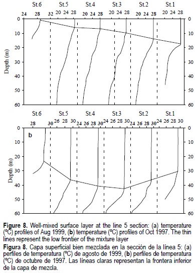
The density variations were more significant in the upper 40-50-m layer and the depth of the mixed layer widely varied horizontally (fig. 8). In August 1999, the stable mixed layer was in state of formation and began from the 5-m depth in the western part to 17-18 m in the eastern part. In October 1997, the mixed layer was well formed and had a well-developed concavity. Besides a dynamic explanation of the origin of this concavity, the distribution similar to that of figure 8 may be caused by the horizontal nonuniformity of vertical mixing. If during the formation period of the mixed layer, the wind is spatially non-uniform (due to the shore protection along the bay, for example), the vertical redistribution of heat will also be non-uniform. Then, the heat content in the vertical water column will remain constant and will not cause density currents in the deep layers.
In order to clarify this point, the dynamic topography variations were calculated (as M = ∫α(z) dz, being a the specific volume and z the depth) with a reference level of 50 m at all stations. The spatial distributions of this parameter, which represents the hydrostatic pressure at 50 m depth, are shown in figure 9 for August 1999 and October 1997. Despite the different meteorological conditions, the mass distribution pattern is similar in both cases, with the difference that in the first distribution a strong gradient is observed that induces an intense flow and, given the geometry of the basin, a second, not stable cyclonic vortex is formed to the northwest. Within the bay there was a low-density nucleus centered at line 4, which is a condition for the existence of an anticyclonic vortex. This structure, as well as the distribution of the surface mixed layer depth, cannot be explained by the nonuniform conditions of vertical mixing, but rather by the local thermohaline processes and the interaction of density currents with the topography of the basin.
Conclusions
The thermohaline structure of the deep waterbody of Bahía de La Paz is formed under the equilibrium between the influence of the atmospheric processes and the water exchange with adjacent regions of the open ocean. During summer, due to the local atmospheric impact, a strong stratification is developed from the surface taht has strong vertical temperature gradients, up to 0.3°C/m, and increased salinity, up to 0.4, because of the negative balance between precipitation and evaporation. In autumn, a surface mixed layer is formed down to 50-m depth, caused by the intense vertical mixing forced by the wind. The nonuniformity of heating and evaporation, and the intrusion of water from the open ocean through the mouths, form the mass distribution characterized by a less dense zone in the first 60 m, in the center of the bay (line 4). This nonuniformity of the three-dimensional thermohaline structure must create the density-gradient currents which, in the actual topography of the basin, compensate the slopes of the isopycnics with a slope greater than 0.5 m/km. This suggests the existence of a stable anticyclonic vorticity of thermohaline origin in the center of the bay.
In the zone with depths greater than 150 m there are no significant temporal variations of the thermohaline variables related to those of the surface layer. The deep body has its inertia and is formed under the influence open ocean waters, but it does not have the T-S characteristics of the Gulf of California Water. This is a local transformation effect, caused by deep mixing in winter and also by the influence of Subsurface Subtropical Waters that enter the Gulf of California through the mouth and have lower salinity than the Gulf of California Water.
The global effect of the El Niño 1997-98 is one of the major factors responsible for the 2.5°C increase in the temperature of the superficial mixed layer during the sampling of October 1997 in the Bahía de La Paz. For the November of 1998 sampling the same argument cannot be used since the winter was approaching and El Niño had already concluded.
Acknoledgements
This work was supported through both the project 3915P-T9607 of the Mexican National Science and Technology Council (CONACyT) and the project 968017 of the Mexican Instituto Politécnico Nacional (CGEPI-IPN). We thank Dr. Ellis Glazier who edited the English-language text, and Dr. Armando Trasviña for providing us with the data on the Espíritu Santo Shoal. We also thank Alberto León-Manilla and Manuel Saldívar-Reyes for ther technical collaboration during field studies.
References
Álvarez-Borrego, L.G. y Schwartzlose R. A. (1979). Masas de agua del Golfo de California. Ciencias Marinas, 6(1-2): 43-63. [ Links ]
Álvarez-Sánchez, L.G., Wyatt, B. y Stivenson, M.R. (1978). Corrientes en la región de la boca del Golfo de California en la primavera de 1970. Ciencias Marinas, 5(1): 105-118. [ Links ]
Asanuma, H., Rago, T.A., Collins, C., Chávez, F. and Castro, C. (1999). Hydrography of Central California Waters during the 1997-8 El Niño. Tech. Rep. NPS-OC-99-01. Naval Postrgraduate School, Monterey, California, 121 pp. [ Links ]
Atkinson, L.P. and Blanton, J.O. (1986). Processes that affected stratification in shelf water. In: C.N.K. Mooers (ed.), Baroclinic Processes on Continental Shelves. Coastal and Estuarine Sciences, AGU Publ., pp. 117-130. [ Links ]
Badan-Dangon, A., Koblinsky, C.J. and Baumgartner, T. (1985). Spring and summer in the Gulf of California. Observations of surface thermal pattern. Oceanologica Acta, 8(1): 13-22. [ Links ]
Blanco-Betancourt, J.R. (1996). Masas de agua y circulación en la capa superior en la entrada del Golfo de California, durante Octubre-Noviembre de 1994. Tesis de Maestría, UABC, Ensenada, México, 140 pp. [ Links ]
Castro, R., Mascarenhas, A.S., Durazo, R. y Collins, C.A. (2000). Variación estacional de la temperatura y salinidad en la entrada del Golfo de California, México. Ciencias Marinas,26(4): 561-583. [ Links ]
Collins, C.A., Garfield, N. Mascarenhas, A.S., Spearman, M.G. and Rago T.A. (1997). Ocean currents across the entrance to the Golf of California. J. Geophys. Res., 102(9): 20927-20936. [ Links ]
Cruz-Orozco R., Martínez-Noriega, C. y Mendoza-Maravillas, A. (1996). Batimetría y sedimentos de la Bahía de La Paz, B.C.S., México. Oceanides, 11(1): 21-27. [ Links ]
Dressler, R. (1982). Investigaciones sobre la constituyente M2 de marea y circulación forzada por el viento en la Ensenada de La Paz, Baja California, mediante un modelo hidrodinámico numérico (HN). Sammlung von Publikationen Dressler, 17 pp. [ Links ]
Jiménez, A., Obeso, M., Alatorre, M.A., Troyo, S. y García, H. (1994). Hidrología de la Bahía de La Paz. Oceanología, 1(2): 115-131. [ Links ]
Lavín, M.F. y Badan-Bangon, A. (1997). Estructura Hidrográfica y Circulación del Golfo de California: Escalas estacional e Interanual. In: M.F. Lavin et al. (eds.), Contribuciones a la Oceanografía Física en México. Monografía No. 3, México City: Unión Geofísica Mexicana, pp. 141-171. [ Links ]
Obeso, N.M., Jiménez A.R.I. y Diéguez, S.T. (1993). Modelación de la Marea en La Bahía de La Paz, B.C.S. Investigaciones Marinas de CICIMAR, 8(1): 15-21. [ Links ]
Roden, G.I. (1958). Oceanographic and meteorological aspects of the Gulf of California. Pacific Science, 12: 21-15. [ Links ]
Roden, G.I. (1972). Thermohaline structure and baroclinic flow across the Gulf of California entrance and in the Revillagigedo Island region. J. Phys. Ocean., 2: 177-183. [ Links ]
Salinas-González, F., Zaytsev, O.V. and Troyo-Diéguez, S. (1997). Corrientes, Mareas y sus Espectros en la Playa Norte de la Barrera Arenosa el Mogote, La Paz B.C.S., México. Oceanides, 12(2): 65-77. [ Links ]
Stern, M.E. (1977). Ocean Circulation Physics. Academic Press, 246 pp. [ Links ]
Torres-Orozco, E. (1993). Análisis volumétrico de las masas de agua del Golfo de California. Tesis de Maestría, CICESE, Ensenada, México, 80 pp. [ Links ]
Villaseñor, C.A. (1979). Distribución vertical de temperatura, salinidad y oxigeno disuelto en la Bahía de La Paz, B.C.S., durante la primavera de 1976. CalCOFI Reps., 20, 146-149. [ Links ]
Wyrtki, K. (1967). Circulation and Water Masses in the Eastern Ecuatorial Pacific Ocean. J. Ocean. Limnol., 1(2): 117-147. [ Links ]
Zaytsev, O.V., Salinas-González, F. and Troyo-Diéguez, S. (1998). Water Dynamics and Mixing Studies in the Coastal Zone of the Gulf of California. In: Proceedings of the Canadian Hydrographic Conference-1998: 267-276. [ Links ]

