


Servicios Personalizados
Revista

Articulo
 Inglés (pdf)
 Artículo en XML
 Referencias del artículo
 Enviar artículo por email
Indicadores
 Citado por SciELO
 Links relacionados
-
 Similares en
SciELO
Similares en
SciELO
Compartir

 Permalink
Estudios de cultura maya
versión impresa ISSN 0185-2574
Estud. cult. maya vol.39 Ciudad de México ene. 2012
Artículos
Laguna de Términos/Río Candelaria Core: Conditions of Sustainable Urban Occupation in the Interior of the Yucatán Peninsula
Joel D. Gunn*, William J. Folan**, John W. Day, Jr.*** y Betty B. Faust****
* Department of Anthropology, University of North Carolina at Greensboro. jgunn3@mindspring.com
** Centro de Investigaciones Históricas y Sociales, Universidad Autónoma de Campeche. wijfolan@mail.uacam.mx
*** Department of Oceanography and Coastal Sciences, School of the Coast and Environment, Louisiana State University. johnday@lsu.edu
**** Departamento de Ecología Humana, Centro de Investigación y de Estudios Avanzados, Unidad Mérida. bettyfaust@sbcglobal.net
Recepción: 16 de noviembre del 2007.
Aceptación: 24 de febrero del 2010.
Resumen
La búsqueda de un eslabón que sirva de enlace entre el colapso de la civilización maya y el clima ha sido retomada periódicamente durante casi un siglo de estudios. Durante la década de los ochenta, comenzamos a desarrollar un modelo climático, paleoclimático y etnográfico de producción hortícola que ayudaría a sustentar un núcleo de vida urbana en un ambiente fundamentalmente hostil a grandes conjuntos de poblaciones. El objetivo de este estudio consiste en tratar de encontrar las condiciones apropiadas para el éxito de un núcleo de civilización basado en el florecimiento arquitectónico urbano en las cuencas interiores de las Tierras Altas con ambientes adversos. Hemos añadido a esas investigaciones unos conceptos nuevos, combinando lo que sabemos de las ciudades del interior (ya abandonadas) y su medio ambiente, incluyendo en este estudio las zonas bajas de la región con depósitos aluviales cerca de las orillas de los esteros de los ríos. El estudio está basado en la cuenca del río Candelaria que fluye por las Tierras Bajas de la zona maya en el actual estado mexicano de Campeche. Campeche está separado de otras regiones de la península de Yucatán por cerros de hasta 400 m de altura. Estas tierras elevadas del interior generan lluvias copiosas que limitan el uso óptimo del suelo y demarcan el paisaje en valles y bajos. Los climas benignos del pasado, la geografía local y las costumbres hortícolas tradicionales parecen haber sido muy importantes para lograr el florecimiento de la civilización en el interior. Los resultados de las muestras recientes obtenidas del fondo del río Candelaria nos sugieren que los mayas establecidos en esta cuenca regularon con obras los efectos de la erosión en su periodo de mayor florecimiento poblacional. Sin embargo, este control se perdió durante las vigorosas oscilaciones climáticas entre los siglos IX y XIII las cuales incluyeron episodios extremos de sequía, lluvia excesiva y la dislocación de poblaciones.
Palabras clave: río Candelaria, Campeche, colapso maya, modelo climático.
Abstract
Pursuit of a link between the collapse of Maya civilization and climate is a subject that has been revisited periodically for nearly a century. In the 1980s, we began to develop a climatic, paleoclimatic, and ethnographic model of horticultural production that would sustain urban life in an environment fundamentally hostile to large population aggregates. Our focus is on the appropriate conditions for the success of civilization, measured by architectural fluorishing, in the interior upland basins of the Yucatán Peninsula. To this we have added new research linking the now-collapsed interior cities and their bajo environments to near-shore deposits at the mouths of rivers. This study is based on the Candelaria River watershed of the southwestern Maya Lowlands in the modern Mexican state of Campeche. Campeche is separated from other regions of the Yucatán Peninsula by hills up to 400 m elevation. These elevated interior lands create important rain shadow effects, limitations on land use, and divide the landscape into valleys and basins. Past climates, local geography, and horticultural customs appear to be important to the success of civilizations in the interior. Results of the recent coring efforts suggest that the Maya of the Candelaria watershed controlled erosion during the period of greatest population, but lost control of it due to the ninth century drought and population dislocations.
Keywords: Candelaria River, Campeche, collapse of Maya, modeling climate.
Introduction
Pursuit of a link between climate and the AD 800 collapse of Maya civilization has been revisited periodically for nearly a century (Brooks, 1970 [1949]; Folan, 1981; Folan et al., 1983; Gill, 2000; Gunn and Adams, 1981; Haug et al., 2001, 2003; Hodell, Curtis and Brenner, 1995; Huntington, 1917). This downside-perspective, however, leaves the question of what facilitated the fluorishing of Maya civilization unanswered. In the 1980s, we began an ethnographic study of existing Maya horticultural practices with the purpose of understanding what sustained Maya civilization for more than 1 000 years (from around 500 BC to AD 800) in an interior environment fundamentally hostile to large population aggregates (Gunn, Folan and Robichaux, 1994, 1995; Gunn and Folan, 2000; Gunn, Matheny and Folan, 2002; Lucero, 2002; Shaw, 2003). We made ethnographic observations on modern farmers, and modeled and measured past and present environments. The contrast between looking at the upside and the downside of civilization distinguishes this effort from our earlier investigations and those of other authors.
In this article, we will briefly review findings of previous research on the building and sustaining of Maya civilization in the Candelaria River watershed of the southwestern Yucatán Peninsula (figure 1). This includes modeling of precipitation/discharge from post-1958 data and studies of Classic Maya-period sediments in the upland basins around the ancient city of Calakmul, the largest of the interior urban areas. We will then offer new information on cores from the mouth of the Candelaria River at the Laguna de Términos. These complimentary views of the river from its beginning to end provide a complete hydrological and climatic picture of the past. We will discuss how and what data were collected from the core, examine some relationships between previous cores in the bajo below Calakmul and the Laguna de Términos core using univariate and bivariate methods. Then we attempt to understand the whole up and down river system through multivariate numerical analysis.
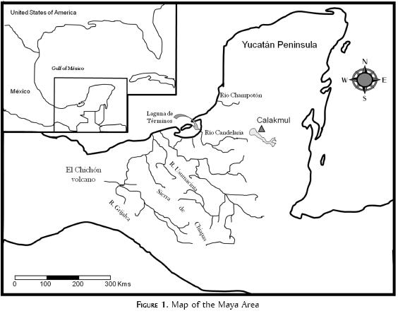
The Candelaria River watershed is located in the southwestern Maya Lowlands in the southern portion of the Mexican state of Campeche and adjacent areas of Guatemala. It encompasses over 13000 km2 and drains virtually the whole of the south end of the state of Campeche and adjacent small areas in Guatemala. It empties into the Laguna de Términos from where the core was taken. The Candelaria River-El Laberinto Bajo system drains all of the territory west of the central hills of the Peninsula that range up to 400 m above sea level. These elevated, interior landforms create climatically and culturally important rain shadow effects (see pluvial anomaly map in Orellana, Islebe and Espandas, 2003: 45) and divide the landscape into valleys and basins (Bautista Zúñiga et al., 2003; Folan, García and Sánchez, 1992; Gatesm 1992; Gunn, Folan and Robichaux, 2003). Just as archaeologists and researchers from related disciplines have found that climate is variable, detailed understanding of the geography of the Maya Lowlands has shown it to be a highly varied landscape requiring considerable time and re-adaptation of cultural customs to adjust to local conditions (Dunning, 1996; Gunn, Folan and Robichaux, 1994, 1995; Pope and Dahlin, 1989).
Research Design
Modern drainage patterns, sediments, and cultures are the end-product of thousands of years of co-evolution of climate and culture. In that sense, the study of the present is the study of the past. We began studies of the modern climate and geomorphology of the Candelaria basin in the 1980s as reported in several publications (Gates, 1992; Gunn, Folan and Robichaux, 1994, 1995 and 2003; Gunn et al., 2002). A river system's morphology and sediments are end-products of millennia of interactions between precipitation, erosion, deposition and cultural intervention, and bears a record of that past in its sediments and morphology. Similarly, the present-day horticulturist's customs are descendant from the practices of their ancient predecessors and bear the marks of past climates. The study of these modern patterns and residues can suggest patterns of alternative behavior to modern patterns (Faust, 1998; Faust and Gunn, 1999; Folan and Gallegos, 1992, 1999), and perhaps anticipate unexpected future shifts of organization in landscapes and societies.
Our current research is focused on newly acquired cores from the mouth of the Candelaria River at the Laguna de Términos. It was our belief that if we could document the conditions of the river system at both the erosional upper, or bajo end, and the sea-side lower or depositional end, we would be better able to characterize the chemical evolution of the river system and its implications for urban life in the interior so far as it can be known. This study attempts to close the loop on our understanding of the Candelaria River biocultural system.
Modeling Climate
To understand the climate sequence of the southwest region for the period of Maya cultural evolution, we devised a model for the last 3,000 years (the Late Holocene). It was calculated as a proportions problem with modern global climate and discharge as knowns, past global climate as known, and past discharge as the unknown. The functions for modern global-to-local climate were obtained by regressing modern global-scale variables with Candelaria River monthly discharge rates (Gunn, Folan and Robichaux, 1994, 1995). These functions were then used with prehistoric indices (proxies) to calculate prehistoric discharge rates (figure 2). Rotational precession was also accounted for.
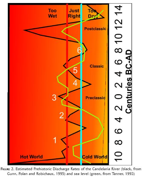
Validation of the model was predicated on known features of the southwestern Yucatan Peninsula climate sequence such as periods of intensive drought around A.D. 200 and A.D. 800 interspersed with periods of moderated climate. These features appeared in the discharge/climate curve (see figure 2). Also, the model provided the additional insight that precipitation would increase dramatically and destructively with global warming, an inference supported by the raising of large parts of the city of Champoton near the River on platforms (Folan et al., 2007). The model projects excessive precipitation early in the time series (before 500 BC) and the Medieval Maximum (AD 950-1250), periods of known global warming. The model was extended to the Champoton and Usumacinta watersheds in 2000 (Gunn and Folan, 1996, 2000). The study showed that, in addition to the impacts of global climate, hydrological parameters differed between basins depending on rain shadow effects, watershed size, topography, geology, and human intervention. In other words, each river basin within the southwest region requires an entirely unique global-to-regional transformation in order to understand the impacts of climate on its civilization.
Modeling Food Production
We assume that in the absence of mass transportation of food stuffs, the construction of massive architectural monuments and public buildings was somewhat dependent on local horticultural productivity. (In addition to swidden horticulture, other means were also used such as raised terrace and yard gardens [Folan, Kintz and Fletcher, 1983; Hansen, 1998].) Through ethnographic interviews of modern swidden horticulturists, we found that productivity depends on two main variables: time of onset of the rainy season, and wet-dry season contrast, which facilitates drying and burning of the slash. Working primarily in the Candelaria and Champoton river systems, interviews showed that the horticultural practices of the local swidden agriculturists or tropical gardeners, referred to as milperos and the gardens as milpa, are related to the global-local climate function. Milpa is a system of planting that makes intensive use of small plots of land in the forest by distributing crops vertically in layers rather than horizontally, as is customary in temperate zone agriculture. Layers including root crops under the surface, surface crops such as squash, and above-surface corn, which provides scaffolding above the surface for climbing plants such as beans.
Interviews with milperos revealed planting strategies that varied with the onset of the rainy season, and through data analysis of the global-local system, we found that onset varies with global average temperature. This is the key link between climate and the quantity of food production (Faust and Gunn, 1999; Folan and Gallegos, 1992; Gunn, Folan and Robichaux, 1994, 1995).
A study in the Champoton River system in the village of Pich showed that milperos' planting strategy in that area is guided by a complicated complex of considerations that includes climate and other factors (Faust and Gunn, 1999; Gunn et al., 2002). Ideally, in order to counteract predators, the members of the village all plant at the same time so that no one first-planter becomes the single victim of all milpa predators. Climate is accounted for by varying the time of the planting. The planting event is coordinated and motivated through saints' festivals that mark the beginning and end of a two-week planting period.
During the last two decades, deforestation has created a drying climate in the study area; Pich is on the southern rim of the Edzná valley. Deforestation is, in effect, a living simulation of climate change from wet-to-dry conditions. To accommodate the later onset of the wet season caused by deforestation and general drying of the climate, villagers have moved their typical planting time from 3 May to 15 June. The beginning and ending dates of each planting period are traditional saints' days and probably have been carried forward from ancient religious practices through a process referred to by anthropologists as syncretism. The current names of some saints appear to be syncretic overlays of earlier deities. During the times when the interior highlands of the Yucatán Peninsula were dotted with large cities, the saints' days would have been marked with grand ceremonies of magnificent proportions to coordinate the activities of large populations. They would be hard to characterize in terms of urban or rural because like today's villages, they would have spent the dry season in cities clustered around community water supplies and wet seasons dispersed to milpas. In today's smaller villages, the festivals are marked by the equivalent occasions of festivals, bull fights, and adulations of the saints (Faust and Gunn, 1999; Gunn et al., 2002).
Our central concern is to discover the conditions in which milpa production rises to the challenge of supporting urban populations. The discharge levels reconstructed for the Candelaria River (Gunn, Folan and Robichaux, 1995, see figure 2) indicate a 200-300 year oscillation of precipitation levels, a periodicity later supported by analysis of lake core data, although from another region of the peninsula (Hodell et al., 2001). Our studies of milperos imply that moderate levels of precipitation, i.e., mid-length rainy seasons, favor maximum horticultural production. The maximum production is dependent on annual cycles of well-marked wet and dry seasons, and falls if the rainy season is too short or too long. Mapping this concept of moderate discharge against the estimated Pre-Columbian discharge pattern (see figure 2) reveals that periods of moderate precipitation occurrences correspond to periods of maximum architectural fluorescences in the Maya Lowlands. We presume, therefore, that architectural production was modulated by horticultural productivity.
El Laberinto Bajo Cores
Collecting five-inch bucket cores from the Laberinto Bajo at three strategic locations (Gunn et al., 2002) revealed a pattern of natural and anthropogenic deposition that coincided with the pattern of estimated river discharge and architectural flourescence (figure 3). Before 3,000 years ago, the bajo appears to have been scoured of sediments in all of the locations that we tested. Apparently the runoff before then was of such a great volume that it carried away any sediments that might have been available for deposition. This coincides with the time of extremely high discharge projected by the climate model (see figure 2).
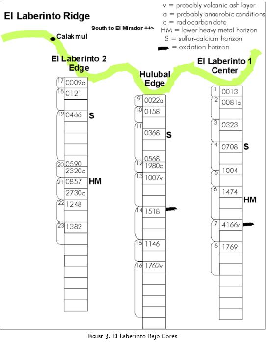
The analysis of the bajo cores was a battery of tests that included various dating techniques (AMS, OCR), soil chemistry and granulometry, phytoliths, and ICP analysis to obtain profiles of elements in 41 samples. The ICP analysis encompassed a wide range of elements, but with special attention paid to the heavy metals. In the interior, horizons of heavy metals reflect episodes of weathering during which the soluble, lighter elements are carried away and the heavier and less soluble elements are concentrated in place. The heavy metals become the signatures of periods of surface stability in a landscape. Deposits without concentrations of heavy metals indicate periods of rapid deposition.
In the Laberinto Bajo south of Calakmul, cores contained prominent heavy metal horizons at the surface at about 500 BC. We believe this reflects a period of deposition and weathering of the bajo bottom before 500 BC (780 BC AMS on soil = mean residence time). After approximately 500 BC, the weathering surface was buried under a layer of calcareous sediments. They correspond to the earliest large-scale building episodes in Calakmul and other cities along the edge of the bajo. The calcareous horizon is thought to have eroded from slopes and surfaces above the bajo. The erosion could have been caused by humans by deforestating the slope for excessive reuse of milpa patches without sufficient fallow intervals. It may also have been caused by excessive use of the forests for converting limestone to plaster for architectural uses (Hansen et al., 2002). The upper level of heavy metals reflects 1,000 years of weathering since the abandonment of the interior cities after the Terminal Classic period.
Other researchers have found similar patterns of intensive Preclassic erosion. McNeil (2006: 147) found decreased pollen concentrations in the Middle and Late Preclassic at Copán indicating rapid deposition. Anselmetti et al. (2007) have cored sediments from Lake Salpeten in northern Guatemala. They found human impact on sediments between about 1,000 BC and AD 900. The period of greatest deposition was between 700 BC to AD 250, also in the Middle and Late Preclassic, also under relatively low population densities. Anselmetti et al. (2007: 917) cite several other similar findings.
In summary, the cycles of deposition, erosion, and urbanization in the upper end of the Candelaria River drainage are synchronized with the cultural phenomena. They indicate that the flourescences of architectural activity coincided with periods of optimal climate that are of moderate precipitation and with contrastive wet and dry seasons. Moderate precipitation and high milpa productivity are key features of the occupation of the interior Yucatán Peninsula by large urban aggregates. In the next section, we turn to the lower end of the Candelaria River system for additional insights into this urban, moisture, and global-change dance.
Maya Agriculture and World Climate
In his book on worldwide impacts of agriculture and urbanization on global climate, Ruddiman (Ruddiman, 2005a; 2005b) found that the carbon dioxide content of the atmosphere departed from what would have been expected at 5,000 BC and methane at 2,500 BC (figure 4). Both mark the growing presence of humans as players in influencing atmospheric composition and global temperature. However, methane has a much greater effect on global temperatures than carbon dioxide. Ruddiman's theory assumes that the earth should have experienced a sustained cooling following 9,000 BC because of precession of the earth's rotation and the related solar emissions effects that cycle precipitates (expected values in figure 4). However, the observed values of methane (a strong greenhouse gas) departed significantly from expected values presumably reflecting global temperatures.
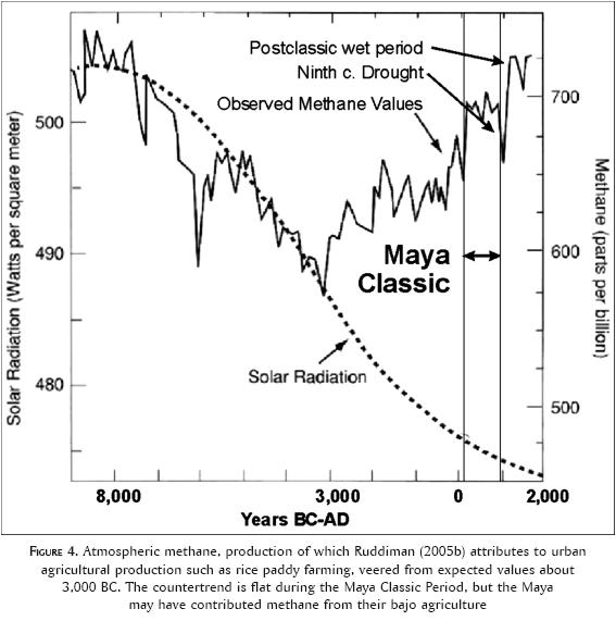
Examining our findings in light of these global measurements, we suggest that the counter trend of global warming in the first millennium AD was such that conditions in the interior of the Yucatán Peninsula were ideal for agricultural productivity. Also, it is clear from Ruddimen's methane data that the Classic Maya period was one of relative stability (between vertical lines) and this was followed by a sharp drop (the ninth century drought) and then a sharp rise (the Medieval or Postclassic too-wet period). The Maya Classic conditions would have included the ideal gardening climate discussed above. After the Maya Classic, the global climate entered a range of behavior that was adverse to occupation by large population aggregates in the interior of the Yucatán Peninsula. These conditions included frequent too-long wet seasons punctuated by cool drought due to volcanic eruptions (Gill, 2000). Ironically, the Maya may have contributed to the too-wet Medieval Maximum through methane emissions from their wetland agriculture, a topic for future research.
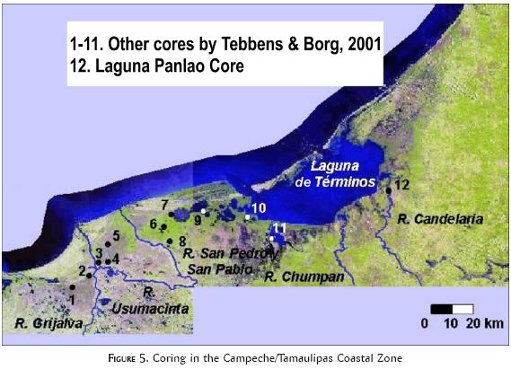
The Candelaria Terminos Panlao Core
In January 2000, a series of 12 cores (Tebbens and Borg, 2001) were drilled into the sediments of the Laguna de Términos and nearby deltas of the major rivers of the Campeche and the Guatemalan highlands (figure 5). The core on the Candelaria River delta was drilled to sufficient depths to reveal the total period of Maya civilization. Our intention was to compare this core with previously analyzed cores from the Laberinto Bajo near Calakmul 170 km to the east. As with the Laberinto Bajo cores, samples were subjected to dating and elemental analysis.
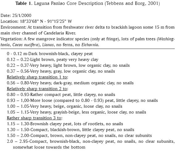
The core was placed in the Candelaria River delta at the transition from freshwater river to brackish lagoon some 15 m from the main river channel. It was about 1 m about the water level at the time the core was taken. The sediments penetrated by the core (table 1) were a sequence of interbedded clays and peats.
Relationships between Bajo and Términos Cores
Given the circumstances of the core, it is assumed that the peats represent mangrove deposition in periods of medium sea level, and higher clay-content levels indicate episodes when the location was seasonally submerged and accumulating terrestrial sediment from overbank deposition. The sharp transitions are periods of low sea level when the location was being eroded.
From what is known archaeologically and sedimentologically of the interior, one would anticipate that terrestrial sources of clay would have been most active during periods of deforestation of land because of overuse, most notably the last 30 years since deforestation of the region, and during the Maya Preclassic (200 BC-AD 200) as discussed above. The geological platform is assumed to be isostatically stable. Tanner's (1993) sea level curve will be used as a general reference for 50 year interval sea levels. Fifty-year time intervals are of interest to us because they resemble the resolution of the archaeological recovery of culturally filtered patterns. In addition to the depositional processes reviewed above from interior archaeological data, the sea level curve also indicates high sea levels at around AD 500 and 1200, and low stands at 600 BC, AD 800, and AD 1600 (see the green line in figure 2).
Although the sea seems to have risen to near its current levels about 8,000 years ago and become relatively stable after 7,000 years ago (Day et al., 2007), most indicators of sea level in the southeastern United States stabilized about 4,000 years ago. The exceptions are clay dunes on the Texas coast which indicated high stands at 6,000 years ago. Other areas with sand beaches do not manifest evidence of stabilization until about 4,000 years ago (Brooks et al., 1986). On the coastline nearer to Laguna de Términos, at the archaeological site of San Andrés in Veracruz, solid evidence indicates the buildup of estuaries at 7,000 years ago soon after worldwide sea level stabilization (Pope et al., 2001). The bottom of the Laguna de Términos core at 2.95 m below the surface dated by AMS to 5,015±50 BP C14 (3,760±50 BC calib.) (Tebbens and Borg, 2001) suggests that the deep, thick peats near the bottom of the core represent the buildup of mangrove somewhat later than on the Veracruz coast. Whether this is due to differences in elevations or processes remains to be investigated. It may be that a different core would yield another two thousand years of important and interesting ecological history.
Sharp transitions are normally interpreted to represent low sea stands during which the surface eroded. Three were observed in the Panlao core (figure 6 B). These we can pose by correlation with AD 1,000. Tebbens and Borg (2001) suspect, based on dating, that a significant interval of time is compressed between 1.30 and 1.46 m below the surface. This interval may, according to the best combination of radiocarbon dates, be as much as 2,430 years (1470 BC to AD 960 calib.). Unfortunately, this spans the entire Preclassic and Classic periods of archaeological chronology. Phosphorus (methods discussed next) is plotted in figure 6C. A temporal mask that correlated the core chronology with calendar dates (Preclassic, Classic, Postclassic) has been imposed on this phosphorus trajectory and will be used through the remainder of the article as a time frame. As can be seen, there is a peak in phosphorus during the Preclassic Period, which may correspond with the globally warm Roman Optimum (200 BC-AD 200) during which sea levels trended higher. While we need not be overly optimistic about what can be compressed into 20-30 cm, there may be a weak sea level signal, even in this much compressed segment of the core. This question will be further addressed by comparison with other elements below.
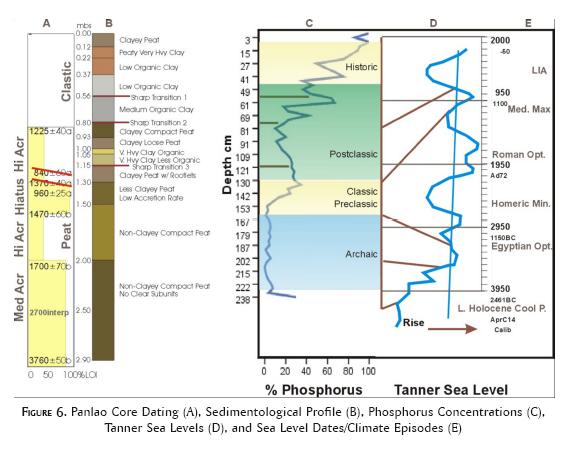
Tebbens and Borg (2001) suggest that high accretion rates between 1700 and 1470 BC could represent Maya deforestation and denudation of the interior. This erosion would correspond to the Early Preclassic, somewhat earlier than other studies cited above. Several ideas alone or in combination may explain the apparent misfit. It could be that the dates are askew. There may be as yet undetected erosional events in the coastal plain; Scarborough (1998) points out that settlement would have been perhaps a half millennium earlier in the coastal zone than in the interior, a date range that would move coastal plain erosion back into the Early Preclassic. The date 1,700 BC coincides with a period of increased estimated precipitation in the Candelaria watershed at the end of the Middle Holocene. It could well be that a marked change in the rainfall regime helped generate the high accretion rates.
Were additional research to be conducted in the Candelaria River delta, this sequence suggests the need for a series of cores from offshore-to-near-shore locations back from the coast to detect the changing loci of deposition. A research design could be devised based on variable thickness of strata and radiocarbon dating of transitions similar to the one followed in this core. It may be that mangrove serves its most important purpose in such a research design by insuring high carbon content and, therefore, datability.
Methods of Analysis
In this study of the Panlao core, our intention was to compare it and the Laberinto Bajo cores (Gunn et al., 2002). Nineteen of the elements run on the bajo cores proved useful (Al, B, Ba, Ca, Cd, Co, Cr, Cu, Fe, K, Mg, Mn, Na, Ni, Pb, S, Si, Sr, Zn). The primary, additional issue for the Panlao core is sea water. Strontium, which was observed in the bajos cores, was of particular interest as it is proportional to the sea level (Gunn, Folan and Robichaux, 1995).
The scope of the analysis was set as follows. The bottom of the core is dated at 5,500 years before the present. If a sample were taken every 1 cm down the core, it would require 295 determinations and the temporal resolution would be 18.64 years on the average although varying with accretion rate. This level of effort was determined to be beyond the resources of the current project, but should this project prove fruitful, an additional, more intensive sampling regime may be attempted in the future, especially in the ranges of low accretion rates. For this project, the number of samples was adjusted downward to one-in-three samples, a sample every three cm, which provides an average temporal resolution of 55.92 years. A temporal resolution of approximately 50 years conforms to the general goals of studying several climatically sensitive locales in the Yucatán Peninsula and Southeastern United States at this resolution (Gunn, 2000). It halves the 100 years resolution of our 1994-1995 modeling of climate change in Campeche, and could provide new temporal insights into the environmental context of the Classic Period Maya. A second core was analyzed from near the mouth of the Grijalva River and will be presented at a future date.
The ICP analysis of 3 cm interval core samples proceeded as follows. The sediment samples were extracted by heating approximately one gram (weighed to 3 decimal places) of dry sediment to about 120 degrees C with 5 mls of concentrated trace metal grade nitric acid for a day. The solution was then evaporated down to about 1.5 mls, diluted to 50 mls, mixed well, and then analyzed after the solids have settled and there is a clear supernatant (no suspended clay particles). Thus, any metals within the crystalline lattice structure of clay minerals were not extracted. The extraction removes all elements that are adsorbed to soil minerals, bound by the organic matter associated with soil minerals, and associated with any amorphous iron and manganese oxides. The extraction does not contain what would be biologically available (as for plant uptake) since some of these processes hold elements firmly, but, it does present those elements that could potentially be released to mobile or biologically available forms. It represents the totality of potentially reactive elements. The sample solution data was converted to a concentration based on sediment sample dry weight.
Results
Twenty-two elements were observed by ICP analysis from 62 samples. All of the elements were present in quantities that exceeded the sensitivity threshold of the instrument. Means for elements (table 2) ranged from 1.2 ppm for cadmium (Cd) to 35,521 ppm for sulfur (S). The lighter elements (Atomic Weight) are present in the sediments in much greater quantities than the heavier elements.
Proportions of Elements in the Laberinto Bajo and Laguna de Términos
A comparison of the elements found in the Laberinto Bajo cores and the Panlao core (figure 7) indicates a down-stream concentration of elements. Not surprisingly, calcium comprises the larger proportion in the bajo, but most other elements are more abundant in the Panlao core. The greater abundance of elements at Panlao is most notable in the elements that are least evident in the bajo cores. The elements leached from the interior were deposited at Panlao. (The sea also may be playing an equalizing role in supplying quantities of these elements through ground water to the Panlao core.)
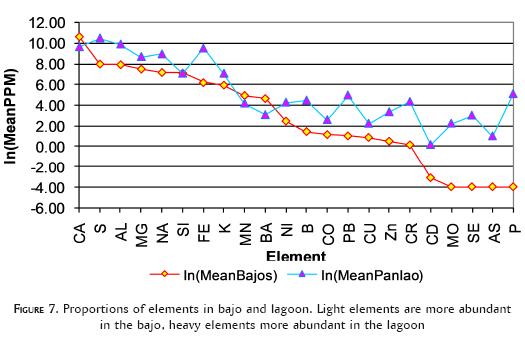
Our initial reaction to finding more heavy elements in the lagoon than in the bajo was that the relationship was reversed from what would be expected. Why would the heavy elements not be more abundant in the weathering source, the interior bajo, and the lighter, more transportable elements more abundant in the low-end lagoon? A possible explanation is that the influence of the sea, circulating along the shore might be bringing in volcanic sands from other sources. For example the Usumacinta River, which also empties into the Laguna de Términos, and which has its origin in more volcanically active zones, might be part of the heavy element picture. Also, Tebbens and Borg (2001) and Nooren et al., (2009, Pozo Petrolero core) found volcanic ash strata in the core, so part of the problem might be atmospheric in origin. This issue will be dealt with in a subsequent section.
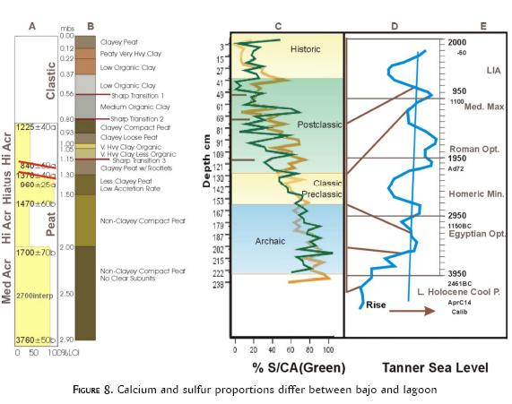
Calcium-Sulfur Proportions
In El Laberinto Bajo cores, calcium and sulfur occurred in somewhat complementary amounts depending on depth. Large amounts of calcium were concentrated toward the top of all cores. Large amounts of sulfur (gypsum) resided at the bottom. These differences were thought to depend on the greater solubility of sulfur and the denudation of the bajo perimeters by humans during periods of intensive land use (Gunn et al., 2002). Because sulfur is more soluble, it would be dissolved and eroded more rapidly than calcium.
In the Panlao core, sulfur and calcium (figure 8) display similar values throughout the depth of the core increasing toward the bottom. Since the two elements are differentially soluble, the correlation between them implies that they arrived at the core location mixed and in equally mobile states, such as in small particles.
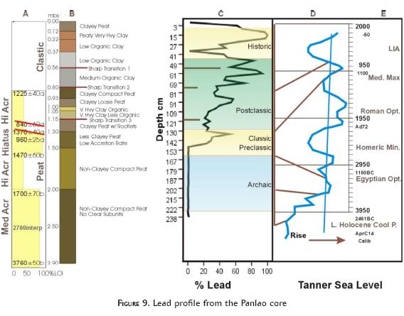
Lead and Weathering Horizons
In the bajos, lead was the most observable indicator of weathering horizons. As lighter elements were dissolved and carried away, heavy elements, especially lead remained because it has the greatest atomic weight of any element and it is relatively insoluble (see table 2). Two weathering horizons were detected in El Laberinto bajo, one before 500 BC, before the Maya deforested the slopes above the bajo, and a Postclassic/Historic horizon. Lead is also interesting because the Romans famously polluted the entire planetary atmosphere by smelting great quantities of it. A lead horizon contemporary with the Roman Empire might result from those activities.
Six spikes appear in the lead profile of the Panlao core (figure 9). The first is during the Terminal Classic. This suggested to us that the Terminal Classic might represent a period during which the Maya lost control of an otherwise sustainable erosion regime. Anselmetti et al.'s (2007) Lake Salpetén core discussed above clearly shows diminished erosion during the period of highest human occupation (Classic) in a 3.8 km2 catchment. The lead concentrations in the Panlao core suggest that the greater scale of the Candelaria drainage (over 13,000km2) also experienced reduced erosion during the Classic period, but there was a spike of severe erosion during the Terminal Classic. This might correlate with greater social disruptions in the Candelaria drainage. For example, the zones of the Structure II pyramid at Calakmul were intensively occupied during the Terminal Classic by intruders from the north (Folan, 2001; Folan, 2003; Folan et al., 1995). They would have been unfamiliar with the horticultural practices by which the Classic occupants controlled erosion.
Multi-Factors and Bears (Aggregates of Elements)
Some information can be gathered by sorting through the elements one at a time as above. However, it is more informative to examine the data as aggregates of correlated elements. This approach provides a more holistic perspective on processes in the total system because the aggregates of elements are interactive subsystems within the whole.
We have spent considerable effort on a model we consider to be key to understanding the interaction of global climate and local humans in the Maya lowlands and probably elsewhere as well. It is referred to conceptually as the "three-bears model". In this model we propose that there is a moderate global temperature at which the balance between locally developed horticulture, rainfall and biota are most efficient. It is a tripartite division of climates that appears to at least make large cities possible in the interior through ideal horticultural conditions (Gunn, Folan and Robichaux, 1993). The three-bears model, we believe applies to the general ecology of the region as it represents an ideal mix of seasonality and rainfall for local vegetation and crops.
The three-bears model emerged from ethnographic, hydrologic and climatic analysis of the Candelaria River watershed and the horticultural patterns of its people (Gunn, Folan and Robichaux, 1994, 1995; Gunn and Folan, 1996; 2000). It is composed of three scenarios, one optimal and two less optimal for quantity and seasonality of precipitation. Moderate global temperatures produce moderate amounts of precipitation with contrasting wet and dry seasons. The contrasts in seasons are important to the annual cycle of slash and burn horticulture: dry for burning and wet for growing. From a global perspective, colder or hotter temperatures either diminish or increase local precipitation out of the ideal range by changing the location of the boundary between the too-moist tropics and the too-dry subtropics on the Yucatán Peninsula. We refer to this tripartite division of climate as the three-bears hypothesis: precipitation and seasonality can be either "too much", "too little", or "just right". "Just right" being the preference of most life forms at all scales in the region. We would feel more confident in this systemic analysis if the three scenarios could be identified as subsystems in El Laberinto-Panlao cores data. In other words, they should be identifiable as aggregates of variables.
To obtain the aggregate patterns, the elements were reduced in complexity by transforming the original data (22 variables or elements) to aggregates or factors of elements representing subsystems in the Candelaria delta depositional system. Factor analysis (Rummel, 1970) showed that the original 22 elements observed in the core samples can be reduced to five aggregates of elements, or factors, that retained 85.1 percent of the original variance in the data (table 3). (Varimax rotation of the factors was used because it is less susceptible to sampling error than straight-forward principle components analysis (Goldenberg et al., 2001).)
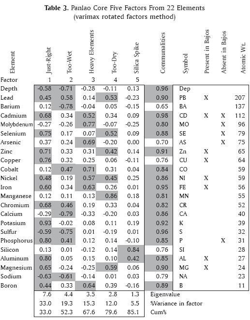
The deposition of heavy elements is expected to represent the most extreme case of erosion, probably drought combined with human occupation (too-dry). To make table 3 easier to read in this perspective, it is sorted on the atomic weight of the elements with the heaviest elements at the top. Briefly, the aggregates of elements appear as follow:
Factor 1 has all of the elements that appeared in the Laberinto Bajo cores (compare numbers greater than +/- 0.40, highlighted in yellow/gray, to "Present in Bajos" column of table 3). They are all signed positive, meaning they increase with time: lead, cadmium, zinc, copper nickel and iron (see also figure 9). On the negative pole of the factor are sodium and sulfur, which is to say that both decrease with time (depth). It might represent the same just-right biotic regime as the bajo cores, i.e., substantial intervention in landscape formation with positive efforts to limit erosion. Sodium decreasing with time suggests elevation above sea level and lead etc., increasing could be human-induced sedimentation.
Factor 2 has both calcium and sulfur suggesting it as the pattern of sediments whose origin are in the local Candelaria drainage; the Candelaria River drains a limestone platform. That the two elements of differing solubility came together suggests that they arrived as particles rather than in solution. Their amounts correspond to that of sodium, decreasing through time. They could be the result of early, slightly above sea level deposition or near shore deposition in the early period of the core, a surmise supported by a decided decline in their prevalence around 1700 BC (3700 BP), a time of abrupt sea level rise at the end of the early Late Holocene regression (see figure 6, Tanner sea level curve). The sodium (sea water) would have infiltrated with time and perhaps be deposited from brackish swamps if they condensed sufficiently to precipitate salt. This factor may represent the too-wet regime, large amounts of discharge bearing lighter sediments to the coast, with the heavy elements being held in moist weathering horizons in the interior.
Factors 3 and 4 need to be examined together as both contain heavy elements almost exclusively. The two aggregates, then, must represent inputs of heavy element-bearing sediments into the delta, or other phenomena such as volcanoes. If factors represent flushing of heavy element-bearing sediments from the land, then they should be accompanied by other indications.
Neither factor is associated with depth, so the influx of heavy elements caused by these factors are episodic rather than trendy over time. This is clearly the case as is shown by the factor scores in figure 10.
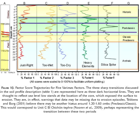
There are three spikes in Factor 4 (figure 10D). One resembles the lead spike in the Terminal Classic as noted relative to figure 9, one in the Postclassic, and one about the beginning of the Historic period. The Terminal Classic coincided with the famous ninth century drought (Folan, 1981; Hodell, Curtis y Brenner, 1995), and the second might be contemporary with a 14th century eruption of El Chichón, an event of worldwide cooling and its consequences such as the black death in Europe (Nooren et al., 2009). The early 16th century also experienced an event of volcanism of unknown origin (Nooren et al., 2009).
It is safe to suggest that at least the Factor 4 erosion events and influxes of heavy elements were associated with too-dry (globally to cold) subsystem of the model based on correlations with events; further proof can be expected from testing for sources of the volcanic debris.
The next question is what does factor 3 represent? It has two major spikes, one in the Postclassic and another in the early Colonial period. Comparing the two factors, the suites of elements in the two factors overlap only in both containing nickel. This suggests very different sourcing. If all of the elements from the bajo appeared in one or the other it would be helpful. Neither contains all or very many more of such elements than the other (compare "Present in Bajos" column). Of the two non-weighty elements, one contains Boron (factor 3) and the other Magnesium (factor 4), not immediately helpful. That lead is present in the bajo and in factor 4 leads one to suspect that it is of interior origin conforming to the other argument above. That, coupled with the fact that it appears to have some relationship to events in the interior such as the ninth century drought leads to the tentative conclusion that its origin is terrestrial and that it represents the too-dry world. Factor 3 remains mysterious and requires further research. It might only differ from factor 4 in subtle ways such as sources of volcanic ejecta and the impact the eruption had on climate.
The fifth factor contains the influence of a silicon spike in the Postclassic and possibly similar events at the beginning and end of the core sequence. Nooren et al. (n.d.) found that layers of strata with high amounts of volcanic debris in them contained considerable silica in the form of sponge spicuals and diatom skeletons, both creatures that consume silica. That the factor 5 silica spike follows the factor 4 sediment influx presumed to be related to the 14th century El Chichón eruption may reflect such a process.
In summary then, we can assign each of the factors to some kind of Earth system phenomenon and its impact on local environment, though not without much confidence at this point in time. This research does, however, make the way clear for further investigations that could verify the associations. Most importantly will be correlating the various tephra layers with known events to obtain a more secure chronology. Secondly, more information is needed on the character of the sediments to characterize the influxes of sediment and provide better information of the subsystems and their association with climate regimes.
Summary
In the interest of discovering additional insights into how the Maya sustained large urban populations in the environmentally hostile interior basins, a sediment core was taken at the mouth of the Candelaria River watershed at the Laguna de Términos. The core was dated by AMS and analyzed by ICP for 22 elements. The elements were in most cases comparable to the elements analyzed in an earlier series of cores in the Laberinto Bajo below Calakmul 170 km to the east.
Comparing the cores showed that on a long term basis, the erosion and transfer of elements from the interior to the coast was as expected. The lighter elements such as calcium and sulfur appear at about the same levels in both environments. However, the heavier elements such as lead, arsenic, selenium, and molybdenum were accumulating in the coastal environment in inverse proportion to their occurrence in the bajo. Also, there were a number of elements that occur in the lagoon sediments that do not appear in the bajo. The spikiness of Factors 3, 4 and 5 suggest that these elements were on the main carried in by episodic depositional events such as would be expected from floods and eruptions.
Lead appears to be ubiquitous in the system. We assume that it is somewhat immune to the extraneous lagoon depositional sources. While dating processes and events indicated in the core proved difficult, especially in the Preclassic and Classic periods, the existing data do indicate that unusual movements of lead to the coast did not occur during antiquity but rather transpired during the Colonial Period or perhaps the late Postclassic. In aggregate, the movement of lead during the Preclassic/Classic is the lowest of any period in the record. (This may be due to slow accretion rates or even a depositional hiatus.) Interpreting this fact at face value suggests that the Maya may have taken special measures to prevent significant removal of sediments to the sea. We know from both Calakmul and Edzná that they undertook massive public works such as canals, aguadas, terraces, field walls and roads (sacbes) that would have conserved both land and water. There is a small spike in lead concentration in the lagoon during what could be the Terminal Classic around AD 800-900. This may reflect events related to the great ninth century drought, essentially the loss of control of the environment by the Classic Maya. There also appear to be spikes of deposition during severe climate and eruptive events such as the fourteenth century and the beginning of the Colonial period.
Conclusions
What were the optimal conditions for maintaining urban populations in the interior of Campeche state? As with previous analyses of climate (discharge of the Candelaria River), ethnography (seasons of planting), archaeological excavations (water facilities and fields) and bajo sediments (build up of land on the bajo edges), the analysis of the Laguna de Términos core brings another perspective to the total problem of building and sustaining cities in the interior of the Yucatán Peninsula and the state of Campeche. The perspective offered by the lagoon core is, as we had hoped, a measure of the outflow of elements from the landscape designed by the Lowlands Maya.
The analysis shows that the sustaining conditions of long term flow delivered a diet of elements that were stripped from the interior uplands enhancing their presence at the lagoon edge. Perhaps it is noteworthy that in spite of the erosion of calcareous uplands documented in the interior bajo cores, the erosion of the heavy element lead seems to have followed the Classic period. This suggests that the Maya may have been able to contain serious erosion that resulted in the removal of heavy elements to the sea.
What is generally known of Maya horticultural practices heretofore is that they caused erosion of slopes above the bajos (Deevey et al., 1979; Gunn et al., 2002), with resulting sediments deposited on the bajo floor at the edge. In previous publications we have suggested that the edges of the bajos were not horticulturally productive until they were calcified by these hill-side sediments. Unfortunately, from this analysis we have little resolution for the Preclassic and Classic but can only understand the long term processes. However, from the small amount of heavy elements in the lagoon, we can infer that the Maya halted the erosion process at the bajo edge and were able to sustain that condition through the 1-2,000 years of their civilization in spite of periodic climatic disruptions. Future research should be directed toward filling this information gap. It may come from additional resolution on the Panlao core, from the other cores collected in this project, or it may require additional coring of the Laguna de Términos margins.
References
Anselmetti, Flavio S., David A. Hodell, Daniel Ariztegui, Mark Brenner and Michael F. Rosenmeier. 2007 "Quantification of soil erosion rates related to ancient Maya deforestation", Geology, 35(10): 915-918. [ Links ]
Bautista Zúñiga, Francisco, Eduardo Battlorri Sampedro, Mario Arturo Ortiz Pérez, Gerardo Palacio Aponte and Miguel Castillo González. 2003 "Geoformas, agua y suelo en la península de Yucatán", Naturaleza y sociedad en el área maya: pasado, presente y futuro, Patricia Colunga-García Marín and Alfonso Larqué Saavedro (eds.). México: Academia Mexicana de Ciencia / Centro de Investigación Científica de Yucatán, 21-35. [ Links ]
Brooks, C. P. E. 1970 Climate through the Ages. New York: Dover. [1949] [ Links ]
Brooks, Mark J., Peter A. Stone, Donald J. Colquhoun, Janice G. Brown and Kathy B. Steel. 1986 "Geoarchaeological Research in the Coastal Plain Portion of the Savannah River Valley", Geoarchaeology, 1 (3):293-307. [ Links ]
Day, John W., Jr., Joel D. Gunn, William J. Folan, Alejandro Yáñez-Arancibia and Benjamin P. Horton. 2007 "Emergence of Complex Societies After Sea Level Stabilized", EOS Transactions, American Geophysical Union, 88 (15):169-170. [ Links ]
Deevey, Edward Smith, Don S. Rice, Prudence M. Rice, Hague H. Vaughan, Mark Brenner and M. S. Flannery. 1979 "Mayan Urbanism: Impact on a Tropical Karst Environment", Science, 19 (206):298-305. [ Links ]
Dunning, Nicholas. 1996 A Reexamination of Regional Variability in the Prehistoric Agricultural Landscape, The Managed Mosaic: Ancient Maya Agriculture and Resource Use, Scott Fedick (ed.). Salt Lake City: University of Utah Press, 53-68. [ Links ]
Faust, Betty B. 1998 Mexican Rural Development and the Plumed Serpent: Technology and Maya Cosmology in the Tropical Forest of Campeche, Mexico. Westport [United States]: Bergin & Garvey. [ Links ]
Faust, Betty B. and Joel D. Gunn. 1999 "Gardens, Ceremonies and Cultural Memory in a Maya Village". In preparation. [ Links ]
Folan, William J. 1981 "Comments on 'The Late Postclassic Eastern Frontier of Mesoamerica: Cultural Innovation along the Periphery' by J. Fox", Current Anthropology, 22 (4):336-337. [ Links ]
Folan, William J., Ellen R. Kintz, and Laraine A. Fletcher. 1983 Coba: A Classic Maya Metropolis. New York: Academic Press. [ Links ]
Folan, William J. and Silverio Gallegos Osuna. 1992 Uso prehispánico del suelo. México: Universidad Autónoma de Campeche. Submitted to the Secretaría de Desarrollo Social. [ Links ]
----------, 1999 "Uso prehispánico del suelo", Naturaleza y cultura en Calakmul, Campeche, María Consuelo Sánchez, William J. Folan, and José Manuel García Ortega (eds.). Campeche: Universidad Autónoma de Campeche, Centro de Investigaciones Históricas y Sociales, 83-90. [ Links ]
Folan, William J., Joel Gunn, Jack D. Eaton and Robert W. Patch. 1983 "Paleoclimatological Patterning in Southern Mesoamerica", Journal of Field Archaeology, 10 (4):453-468. [ Links ]
Folan, William J., Joel D. Gunn and María del Rosario Domínguez Carrasco. 2001 "Triadic Temples, Central Plazas, and Dynastic Palaces: A Diachronic Analysis of the Royal Court Complex, Calakmul, Campeche, Mexico", Royal Courts of the Ancient Maya: Data and Case Studies, Takeshi Inomata and Stephen D. Houston (eds.), vol. II. Boulder [United States]: Westview, 223-265. [ Links ]
----------, 2003 "Templos triádicos, plazas centrales y palacios dinásticos: un análisis diacrónico del complejo de la Corte Real de Calakmul, Campeche, México", Enciclopedia histórica de Campeche: los orígenes, Román Piña Chan (ed.), vol. I. México: Miguel Ángel Porrúa, 377-460. [ Links ]
Folan, William J., Abel Morales López, Raymundo González Heredia, José Antonio Hernández Trujeque, Lynda Florey Folan, David Bolles, Joel D. Gunn and María del Rosario Domínguez Carrasco. 2007 "The Port City Of Champoton (Chakan Putun), Campeche, Mexico: A Major Middle Preclassic-To-Late Postclassic Central Place on the West Coast of the Yucatan Peninsula", El patrimonio arqueológico maya en Campeche: novedades, afectaciones y soluciones, Ernesto Vargas and Antonio Benavides (eds.). México: Universidad Nacional Autónoma de México, Centro de Estudios Mayas (Cuadernos del Centro de Estudios Mayas, 35). [ Links ]
Folan, William J., Joyce Marcus, Sophia Pincemin, María del Rosario Domínguez Carrasco, Laraine Fletcher and Abel Morales López. 1995 "Calakmul: New Data from an Ancient Maya Capital in Campeche, Mexico". Latin American Antiquity, (4):310-334. [ Links ]
Folan, William J., José Manuel García Ortega and María Consuelo Sánchez González. 1992 Programa de manejo de la reserva de la biosfera Calakmul, Campeche. 4 vols. Campeche: Universidad Autónoma de Campeche, Centro de Investigaciones Históricas y Sociales. [ Links ]
Gates, G. 1992 "Physiology, Geology, and Hydrology of the Calakmul Biosphere Reserve". Report submitted to the MacArthur Foundation of Chicago through Biocenosis, Mexico S.A. and the Centro de Investigations Históricas y Sociales de la Universidad Autónoma de Campeche. [ Links ]
Gill, Richardson B. 2000 The Great Maya Droughts: Water, Life, and Death. Albuquerque: University of New Mexico Press. [ Links ]
Goldenberg, Stanley B., Christopher W. Landsea, Alberto M. Mestas-Nuñez and William M. Gray. 2001 "The Recent Increase in Atlantic Hurricane Activity: Causes and Implications", Science, 293: 474-479. [ Links ]
Gunn, Joel D. 2000 "Sub-Regional Perspectives from Radiocarbon Dates: Spatio-Temporal Distributions of First Millennium A.D. Radiocarbon Dates in the Eastern United States", Tracing A.D. 536 and Its Aftermath: The Years Without Summer, Joel D. Gunn (ed.). Oxford: British Archaeological Reports (872), 99-108. [ Links ]
Gunn, Joel D., William J. Folan and Hubert R. Robichaux. 1993 "Global Climate and Episodic Urbanism in the Maya Lowlands". Paper presented at the 1993 Meeting of the International Association of Ethnological and Archaeological Sciences (IUAES), Mexico City. [ Links ]
----------, 1994 "Un análisis informativo sobre la descarga del sistema del río Candelaria en Campeche, México: reflexiones acerca de los paleoclimas que afectaron a los antiguos sistemas mayas en los sitios de Calakmul y El Mirador", Campeche Maya Colonial, William J. Folan (ed.). Campeche: Universidad Autónoma de Campeche (Colección Arqueología), 174-197. [ Links ]
----------, 1995 "A Landscape Analysis of the Candelaria Watershed in Mexico: Insights into Paleoclimates affecting Upland Horticulture in the Southern Yucatan Peninsula Semi-Karst", Geoarchaeology, 10 (1): 3-42. [ Links ]
----------, 2003 "Urbanismo episódico en las Tierras Bajas de los mayas: un modelo de sistema complejo para la agricultura moderna y el clima antiguo", Naturaleza y sociedad en el área maya: pasado, presente y futuro, Patricia Colunga-García Marín and Alfonso Larqué Saavedro (eds.). México: Academia Mexicana de Ciencia / Centro de Investigación Científica de Yucatán, 119-130. [ Links ]
Gunn, Joel D. and Richard E. W. Adams. 1981 "Climatic Change, Culture, and Civilization in North America", World Archaeology, 13 (1): 85-100. [ Links ]
Gunn, Joel D., and William J. Folan. 1996 "Tres Ríos: una superficie de impacto climático global interregional para las Tierras Bajas de los mayas del suroeste (la cuenca de los ríos Candelaria, Usumacinta y Champoton)", Los investigadores de la cultura maya 5. Campeche: Universidad Autónoma de Campeche, 57-79. [ Links ]
----------, 2000 "Three Rivers: Subregional Variations in Earth System Impacts in the Southwestern Maya Lowlands (Candelaria, Usumacinta, and Champoton Watersheds)", The Way the Wind Blows: Climate, History, and Human Action, Roderick McIntosh, Joseph A. Tainter and Susan Keech McIntosh (eds.). New York: Columbia University Press, 263-270. [ Links ]
Gunn, Joel D., J. E. Foss, William J. Folan, María del Rosario Domínguez Carrasco and Betty B. Faust. 2002 "Bajos Sediments and the Hydraulic System of Calakmul, Campeche, Mexico", Ancient Mesoamerica, 13 (20): 297-315. [ Links ]
Gunn, Joel D., Thomas G. Lilly, Cheryl Claassen, John Byrd and Andrea B. Shea. 1995 Osprey Marsh: Archaeological Data Recovery Investigations at Sites 38BU905 and 38BU921 Along the Hilton Head Cross Island Expressway, Beaufort County, South Carolina. Raleigh [United States]: Garrow & Associates. Submitted to the South Carolina Department of Transportation, Columbia S.C. [ Links ]
Gunn, Joel D., Ray T. Matheny and William J. Folan. 2002 "Climate-Change Studies in the Maya Area: A Diachronic Analysis", Ancient Mesoamerica, 13: 79-84. [ Links ]
Hansen, Richard D. 1998 "Incipient Maya Wetland Agriculture: Definition of Ancient Systems and Sustainable Application in Contemporary Rainforest Populations". MS on file, Institute of Geophysical and Planetary Physics, University of California, Los Angeles, and Foundation for Anthropological Research and Environmental Studies (FARES). [ Links ]
Hansen, Richard D., Steven Bozarth, John Jacob, David Wahl and Thomas Schreiner. 2002 "Climatic and Environmental Variability in the Rise of Maya Civilization: a Preliminary Perspective from the Northern Peten", Ancient Mesoamerica, 13: 273-295. [ Links ]
Haug, Gerald H., Detlef Gunter, Larry C. Peterson, Daniel M. Sigman, Konrad A. Hughen and Beat Aeschlimann. 2003 "Climate and the Collapse of Maya Civilization", Science, 299 (5613): 1731-1735. [ Links ]
Haug, Gerald H., Konrad A. Hughen, Daniel M. Sigman, Larry C. Peterson and Ursula Röhl. 2001 "Southward Migration of the Intertropical Convergence Zone through the Holocene", Science, 293 (5533): 1304-1308. [ Links ]
Hodell, David A., Jason H. Curtis and Mark Brenner. 1995 "Possible Role of Climate in the Collapse of Classic Maya Civilization", Nature, 375: 391-394. [ Links ]
Hodell, David A., Jason H. Curtis, Mark Brenner and Thomas Guilderson. 2001 "Solar Forcing of Drought Frequency in the Maya Lowlands", Science, 292 (5520): 1367-1370. [ Links ]
Huntington, Ellsworth. 1917 "Maya Civilization and Climatic Change". Paper presented at the XIXth International Congress of Americanists, Washington, DC. [ Links ]
Lucero, Lisa J. 2002 "The Collapse of the Classic Maya: A Case for the Role of Water Control", American Anthropologist, 104 (3): 814-826. [ Links ]
McNeil, Cameron L. 2006 "Maya Interactions with the Natural World: Landscape Transformation and Ritual Plant Use at Copan, Honduras". Dissertation, City University of New York. [ Links ]
Nooren, C. A. M., Wim Z. Hoek, Leo A. Tebbens and Ana Lillian Martín Del Pozzo. 2009 "Tephrochronological Evidence for the Late Holocene Eruption History of El Chichón Volcano, México", Geofysica Internacional, 48 (1): 97-112. [ Links ]
Orellana, Roger, Gerald Islebe and Celene Espandas. 2003 "Presente, pasado y futuro del los climas de la península de Yucatán", Naturaleza y sociedad en el área maya: pasado, presente y futuro, Patricia Colunga-García Marín and Alfonso Larqué Saavedro (eds.). México: Academia Mexicana de Ciencia and Centro de Investigación Científica de Yucatán, 37-52. [ Links ]
Pope, Kevin O. and Bruce H. Dahlin. 1989 "Ancient Maya Wetland Agriculture: New Insights from Ecological and Remote Sensing Research", Journal of Field Archaeology, 16 (1): 87-106. [ Links ]
Pope, Kevin O., Mary E. D. Pohl, John G. Jones, David L. Lentz, Christopher von Nagy, Francisco J. Vega and Irvy R. Quitmyer. 2001 "Origin and Environmental Setting of Ancient Agriculture in the Lowlands of Mesoamerica", Science, 292 (5520): 1370-1373. [ Links ]
Ruddiman, William F. 2005a "How did Humans First Alter Global Climate?", Scientific American, 292 (3): 46-53. [ Links ]
----------, 2005b Plows, Plagues, and Petroleum: How Humans Took Control of Climate. Princeton [United States]: Princeton University Press. [ Links ]
Rummel, Rudolph J. 1970 Applied Factor Analysis. Evanston [United States]: Northwestern University Press. [ Links ]
Scarborough, Vernon L. 1998 "Ecology and Ritual: Water Management and the Maya", Latin American Antiquity, 9 (2): 135-159. [ Links ]
Shaw, Justine M. 2003 "Climate Change and Deforestation", Ancient Mesoamerica, 14 (1): 157-167. [ Links ]
Tanner, William F. 1993 "An 8000-Year Record of Sea-Level Change from Grain-Size Parameters: Data From Beach Ridges in Denmark", The Holocene, 3 (3): 220-231. [ Links ]
Tebbens, Leo A. and K. van der Berg. 2001 "Middle-Late Holocene Flood Basin Record of the Usumacinta-Grijalva Delta (SE Mexico): Deltaic Evolution and El Chichón Eruptive History". Ms. on file at the Centro de Investigaciones Históricas y Sociales, Universidad Autónoma de Campeche. [ Links ]
Información sobre los autores.
Joel D. Gunn. Estadounidense. Doctor en Antropología por la Universidad de Pittsburgh. Ha participado en proyectos arqueológicos en Europa, Estados Unidos y México. Ha publicado libros, capítulos y artículos sobre Calakmul, Champotón y Oxpemul, además de un libro y numerosos artículos y capítulos sobre la paleoclimatología. Actualmente es miembro de la Facultad de Antropología de la Universidad de Carolina del Norte, Greensboro.
William J. Folan. Estadounidense. Doctor en Antropología por la Universidad de Illinois del Sur. Ha sido director de proyectos de investigación básica en México, Canadá y Estados Unidos. Es director e investigador emérito del Centro de Investigaciones Históricas y Sociales "Dr. Román Piña Chan" de la Universidad Autónoma de Campeche desde 1981. Ha publicado libros, capítulos en libro y artículos en México, Canadá, Estados Unidos y Europa. Es miembro del Sistema Nacional de Investigadores (México).
John W. Day Jr. Estadounidense. Profesor emérito del Departamento de Oceanografía y Ciencias Costeras de la Escuela de Costas y Medio Ambiente de la Universidad Estatal de Luisiana, donde ha dado clases desde 1971. También ha colaborado con la Universidad de Campeche y el Instituto de Ecología de Xalapa, México. Sus numerosas publicaciones (más de 200 textos dictaminados) tratan sobre la ecología y el manejo de los ecosistemas de la costa y los humedales. Recibió su grado de doctor en Ciencias Marinas y Ciencias del Medio Ambiente en la Universidad de Carolina del Norte. Ha estudiado los ecosistemas costeros de México y ha dirigido una exhaustiva investigación sobre la ecología y el manejo de la región del delta del Misisipi durante los últimos treinta años.
Betty Bernice Faust. Estadounidense. Etnógrafa y ecóloga humana, investigadora independiente asociada a la Universidad Autónoma de Campeche (México), a la Universidad de California en San Diego y a la Universidad de Nueva York, en Syracuse. Jubilada del Centro de Investigación y de Estudios Avanzados del Instituto Politécnico Nacional (México). Entre sus publicaciones destacan: "Mexican Rural Development and the Plumed Serpent" (1998); "Maya Environmental Successes and Failures in the Yucatan Peninsula" (2001); y en colaboración con Richard Bilsborrow, "Maya culture, population, and the environment on the Yucatán Peninsula" (2000).

