


Serviços Personalizados
Journal
Artigo
 Inglês (pdf)
 Artigo em XML
 Referências do artigo
 Enviar este artigo por email
Indicadores
-
 Citado por SciELO
 -
 Acessos
Links relacionados
-
 Similares em
SciELO
Similares em
SciELO
Compartilhar

 Permalink
Investigación económica
versão impressa ISSN 0185-1667
Inv. Econ vol.70 no.278 Ciudad de México Out./Dez. 2011
The sources and evolution of inequality in Mexican ejidos
Fuentes y evolución de la desigualdad en los ejidos mexicanos
Jennifer Alix–Garcia*
Department of Agricultural and Applied Economics, University of Wisconsin, <alixgarcia@wisc.edu>.
Received June 2011.
Accepted October 2011.
Abstract
This paper examines the sources of inequality in the Mexican common property communities (ejidos), both in the past and in the present. It uses as a proxy of historical inequality the distribution of land at the time of the Agrarian Reform, and as a proxy for current distribution the number of cattle held by individuals. Possible hypotheses of factors affecting the distribution are pre–colonial population densities, differing elegibility rules through the course of the Agrarian Reform, and geography. Descomposition of the inequality measures shows that land inequality is much higher between than within ejidos, with the opposite being true for cattle inequality. Higher precolonial population densities are shown to decrease the average amount of private land and of cattle held by ejido members, and to decrease within ejido–land inequality while they increase within–ejido cattle inequality. Ejidos formed during the early period of the reform have significantly larger land endowments, and much greater inequality cattle distribution within and between ejidos, even while controlling for other factors. This suggests roles for both geography and institutions in the determination of the distribution of assets in rural Mexico.
Key words: inequality, Mexico, common property.
JEL Clasiffication: **D33, O12, Q15.
Resumen
Este trabajo analiza las causas de la desigualdad en las tierras de propiedad comunal en México, llamadas ejidos, tanto en el pasado como en el presente. Como indicador aproximado de la desigualdad económica en la época de la Reforma Agraria se utilizó la distribución de tierras, mientras que para analizar la desigualdad actual se tomó el número de cabezas de ganado por persona. Los factores explicativos de la distribución de la tierra durante la época de la Reforma Agraria que se propusieron son: la distribución geográfica de la densidad poblacional en la era pre–colonial, diferentes reglas de elegibilidad puestas en práctica durante el proceso de la Reforma Agraria y aspectos geográficos. La descomposición de las mediciones de la desigualdad muestra que la desigualdad muestra que la desigualdad en la tenencia de tierra es mayor entre ejidos que dentro de cada ejido, no cumpliéndose esta relación cuando se analiza la desigualdad a través del ganado. A mayor densidad poblacional pre–colonial disminuye el monto de la tierra privada y el ganado de los ejidatarios, así como la desigualdad de la propiedad de la tierra dentro de cada ejido, pero se incrementa la desigualdad medida en términos de cabezas de ganado por persona. Los ejidos formados durante la primera etapa de la Reforma Agraria presentan mayor dimensión, y una mayor desigualdad cuando son medidos a través de las tenencias de ganado. Finalmente, el aspecto geográfico es un importante determinante tanto de la distribución de la tierra y como del ganado, ya sea entre o en cada ejido, incluso tomando otras variables como control. Lo que sugiere que tanto los aspectos institucionales como geográficos son importantes determinantes de la distribución de activos en el sector rural mexicano.
Palabras clave: Desigualdad, México, propiedad común.
INTRODUCTION
This paper studies the roots of inequality in rural Mexico, and examines its evolution over time. It is concerned with identifying historical sources of inequality and their influence on the present distribution of income. In particular, it examines three different influences on current wealth distribution: pre–colonial population density, land reform policy, and geography.
There are two key measures of wealth used in this paper: historical land holdings determined at the time of post–Revolutionary agrarian reform, and measures of the number of cattle per household taken in 2002. It will be shown that both measures are highly correlated with other income indicators, and that the first is deterministic of the second, suggesting persistence in inequality across time. Using survey data from 406 ejidos and comunidades (common property villages), this paper documents how pre–colonial population density, the timing of the Agrarian Reform, and geographic characteristics determined the division of land at the time of the founding of each ejido, and how these influences carry through to the distribution of present–day wealth.
Understanding the roots of inequality is both a moral and an economic obligation. Even if one were unconcerned with principles of justice, the empirical evidence that inequality has important effects on the economy is mounting. In many studies, inequality is taken as given by researchers. At a macro–economic level, changes in inequality have been shown to have a nonlinear relationship with economic growth and a positive relationship with civil wars and social unrest (Banerjee and Duflo 2003, Collier and Hoeffler 2004). Other work has established that the effectiveness of income growth in reducing poverty is compromised in high inequality countries (World Bank 2006). Household level studies have shown inequality to reduce productivity and civic participation, and to have mixed effects on common property resource management (Bardhan 2000; Banerjee et al. 2001; Cardenas 2003; Alix–Garcia 2007, 2008).
The present paper finds itself in the company of both across– and within–country studies of inequality. Sala–i–Martin (2006) reviews the former literature and shows decreases in world income inequality over time. Explanations for variation in income can be found in the classic cross–country growth literature which highlights the importance of saving rates, integration, geography, and institutions.1 Within–country techniques examining variation in income have been proposed by the literature on inequality decomposition, both by subgroups, as in Cowell and Jenkins (1995), and by income source, as in Theil (1979), and inform the analysis in this paper.
This study discusses the potential role of pre–colonial population density, land reform policy, and geography in determining the wealth distribution. In particular, high densities of indigenous populations at the time of the Conquest may have had an important role in determining the settlement patterns of the Spanish and the persistence of particular institutions within ejidos. High densities may have limited the ability and willingness of the Spanish to establish good institutions, relying instead on exploitation of native populations to extract goods, and may simply have limited the ability of the Spanish to distribute large tracts of land. This echoes the reversal of fortune logic presented by Acemoglu et al. (2002) with regards to the distribution of income between countries. It is also possible that these high densities would have affected the way in which land was distributed within ejidos, as indigenous traditions are more likely to have endured where populations were dense.
The current land distribution in the ejidos was determined at the time of the Agrarian Reform, when villages applied for restitution or distribution of agricultural lands. The eligibility rules and administrative process changed throughout the reform, which lasted from 1915 until 1991, and this paper argues that these rules may have had a lasting influence on the amount of land distributed to each village as well as the distribution of private lands within these villages. On a very basic level, as the Reform progressed, less land was available. One would therefore expect to observe less land given out over time. In addition, in the earliest years of the Reform, distribution excluded workers on haciendas. Changes in eligibility rules to allow these workers to request land (after 1934) are expected to have an impact on the character of the communities which formed after this time, and hence on the distribution of land within particular ejidos. Finally, given that land productivity is highly variable across Mexico, one would expect greater variation in land distribution within ejidos where there is higher variation in land quality. It is also possible that variation in land quality across ejidos affected the total amount of land distributed to villages at particular periods in time.
The data shows that the allocation of private land undertaken at the time of the Agrarian Reform within and between the jidos is highly correlated with other wealth measures, including presence of a vehicle, receipt of government anti–poverty subsidies, cattle holdings, and migration to the United States (U.S.). Decomposition of land inequality reveals that this inequality is much higher between ejidos than within them, and that the opposite is true of cattle inequality, although the measures of between ejido cattle inequality are very similar to those of land. Pre–colonial populations, the date of ejido founding, and geographic characteristics are have important impacts on the distribution of land within and between ejidos. Specifically, more dense pre–colonial populations are positively correlated with lower allocations of land from the Agrarian Reform, and with smaller cattle herds. They are also negatively correlated with land inequality within the ejidos —probably because many of the ejidos in these regions are entirely managed as common property. On the contrary, presence in a Mayan region is positively correlated with inequality in current assets as measured by cattle. One possible explanation of this phenomenon is that this distribution is simply a reflection of a traditionally hierarchical society. The data also shows that ejidos formed early on in the Reform tend to have been allocated less land, although early formation does not appear to have affected the between–ejido distribution of cattle. Early–formed ejidos, on the other hand, tend to have highly unequal cattle distributions within their boundaries. Finally, geographic variables exhibit a strong influence on both within and between ejidal inequality, in the past and the present. Higher variation in quality tends to lead to great variation in within–ejido distributions, and between ejidal inequality is strongly driven by the presence of temperate forests —a proxy for higher quality soils.
Although the data do not permit the establishment of causality, it does allow for the examination of differences in institutional outcomes across pre–colonial populations and year of ejido formation. It shows political concentration and absence of rules regulating commons use in the Mayan region, and instability of property rights in the Aztec region, relative to those ejidos found outside of these regions. Nonetheless, the correlations are suggestive of the deterministic nature of institutions and geography together shaping the distribution of both past and present wealth.
The paper begins by providing a framework to analyze the potential sources of inequality in rural Mexico. In that section, I detail the potential roles of pre–Colonial populations, the timing of land acquisition, and the geographic characteristics of the regions in which ejidos found themselves in determining the distribution of resources. Section 3 describes the data and presents simple summary statistics on assets and inequality in the study communities. Section 4 shows a decomposition of total land inequality into within and between–village components, while section 5 analyzes the determinants of these, including the relationship between timing of ejido formation, pre–colonial population density, and institutional outcomes. The final section concludes.
SOURCES OF INEQUALITY
This section presents a brief history of land tenure in Mexico, as well as discussing potential geographical and historical sources of inequality. The focus of the analysis is the ejidal sector, which is unique to Mexico, but is of general interest as an example of the influence of history and geography on land tenure.2 It is of particular interest to scholars of Mexico because of the quantity of resources controlled by ejidos, and the number of communities involved. The total number of ejidos is nearly 29 000. Ejidos presently hold over 90 million hectares of land (46% of the country) and contain 80% of the remaining forest in Mexico.
Pre–Colombian population and institutions
For the purpose of this paper, the key features of the pre–Colombian societies are those which could have influenced either the distribution of parcels of land across the entire country, or the propensity of groups of individuals to divide up land in a particular fashion. With regards to the first, it is clear that the presence of large indigenous populations, such as those of the central plateau and Yucatan peninsula, must have had an impact on the ability of the Spanish to establish settlements. It is therefore possible that the reversal of fortune documented across countries by Acemoglu et al. (2002) could potentially be at play in Mexico as well. The argument is that dense settlements of indigenous populations at the time of the Conquest could have substantially impacted the institutions established by the Spanish through two avenues. First, such densities could have made extractive institutions (i.e., enslavement of native Mexicans) more convenient. Second, the presence of already–established populations would have made settlement more difficult.
In the face of such difficulties, the Spanish might have made greater inroads in developing infrastructure and institutions in places which were less densely populated. They may have spent less energy establishing true settlements, with attendant schools, health care, roads, etcetera, in places where they were a minority in the midst of a hostile majority. In particular, they would have had more success in promoting private property and the mechanisms to safeguard it in areas which were sparsely inhabited by indigenous populations. In densely populated areas, they would exploit existing structures to work the land and extract minerals, but invest little in infrastructure and institutions.
It is worth discussing differences between the Mayan and Aztec regions. At the time of the Conquest, the Aztecs had a significantly developed urban population, in stark contrast with the Mayans (Smith 2005). Because of the centralized nature of Aztec government, the subjugation of major urban centers facilitated the collapse of the entire chain of command, and hence a relatively easy victory for the Spanish. Around the same period, it is thought that the traditionally egalitarian societies of the central plateau of Mexico were in the midst of an evolution towards a more hierarchical system. In particular, it was just before the arrival of the Spanish that heads of Aztec villages came to have special lands larger than those of the majority of the village (Simpson 1934). As is true in present–day ejidos, some of the land was preserved as a commons, while other plots were farmed individually.
This process of unequal land division and the formalization of private property was deepened by the Spanish, who were often awarded lands encompassing several indigenous villages as reward for their efforts in the name of the crown. Mayan society, on the other hand, while extremely hierarchical, was also quite dispersed, using urban centers mostly for religious activities (Coe 1998). The dispersed nature of their governance structure led to difficulties for the invading Spanish; the conflict between the colonists and the Mayans of the Yucatan Peninsula is legendary, culminating in the Yucatan's Caste War, which lasted from 1847 to 1901 (Reed 1964). It is therefore not clear that the exact predictions of the Reversal of Fortune should hold —the less dense population of Yucatan may have made it more complicated to establish a Spanish hierarchy than the highly concentrated population of the Aztecs. However, both areas should have been more difficult to invade than the sparsely populated north of the country. Nonetheless, it is certainly plausible that the pre–colonial populations influenced the settlement patterns of the Spanish, and that these patterns were echoed by the distribution of land by the Reform. This land distribution would subsequently have determined the income growth of households receiving it. In particular, one could argue that places with more dense populations were more likely to be able to take advantage of the opportunity inherent in the Agrarian Reform, and that they were better positioned to translate land into other forms of wealth at a later stage. However, one might also point out that the difficulty of distributing vast tracts of land as a result of the pre–existing populations may not have had direct institutional effects —it simply may have made land relatively scarce in indigenous regions.
Finally, the already–established populations came with a set of cultural norms governing behavior. While the indigenous civilizations may have been becoming more hierarchical, the Spanish at the time of conquest usurped the role of the traditional elites and subjugated the masses, perhaps more intensively in the plateau than in the south. It seems plausible that the traditional culture of common resource management would affect the distribution of land within particular ejidos. If this is the case, then one might expect indigenous regions to have greater equality within ejidos.
The Agrarian Reform
By 1910, it has been estimated that almost one–half of the total rural population of Mexico were resident laborers on haciendas or smaller private holdings (Sanderson 1984). The general disenfranchisement of this class was rich fodder for revolutionaries. It is not surprising, therefore, that one of the first acts of the Revolutionary government headed by Carranza was to establish the legal machinery needed to carry out land reform with the Decree of 6 January, 1915. This act began the Agrarian Reform process in Mexico, which continued with a variety of modifications until 1991, when it was officially declared over and the government began the arduous "new agrarian reform" policies epitomized by Programa de Certification de Derechos Ejidales y Titulación de Solares Urbanos (PROCEDE), a land certification program.
Lands were awarded to groups of farmers to manage and work as commons.3 The first feature of the ejido system that is important for our purposes is the unusual nature of their land tenure arrangement. Ejidos generally have two types of land —private parcels, to which ejido members have rights to a certain amount of hectares in a particular place, and common land, to which members have a right usually defined by a percentage of the commons. Private land is not transferable, and rights to parcels and the commons, by law, can only be passed down to one family member. The private ejidal land distribution was established at the founding of each ejido and serves as a measure of historical inequality for the purposes of this paper.4 Indigenous communities, however, tend to have maintained their entire land holdings as commons.
The timing of a community's receipt of land plays a role in the analysis, as it may have affected both the total amount of land given to villages, as well as the character of the individuals to whom the land was allocated. The laws governing the distribution of land, and the characteristics of the land available, changed considerably over time. According to Sanderson (1984), the land reform got off to a slow start. In 1915–1934 period, despite the promises of the Revolution, very little land was given out, and most of that went to the states of Central Mexico, which had provided important support to the Revolution.
Although a variety of efforts were made to improve the efficiency of the process, it was plagued by administrative complications prohibitive to most potential land recipients. The Cárdenas administration of 1934–1940 marked a significant change in the attitude of the administration towards land reform. Its most important adjustment to the Reform was to allow hacienda workers to receive land. Prior to 1934, the Reform was limited to the restoration of land to agricultural villages and the distribution of land from abandoned haciendas. Over the 1934–1940 period, large amounts of land, generally of good quality, were expropriated and distributed. Almost all the irrigated land that was given out during the entire Reform was distributed before 1940.
The period between 1940 and 1970 represents the rapid industrialization of Mexico and a series of administrations bent on weakening the land reform. The majority of the land distributed after 1940 was classified as pasture. The more limited, lower quality land and unfavorable attitude of the government made receiving ejidal land more difficult during this time, with some increases in accessibility in the late 1960s in response to pressure from the countryside.
Figure 1 reprints Sanderson's (1984) graph of presidential resolutions over time. A positive resolution represents a distribution of land to an individual or community, and the total are all of the requests made for land. It seems likely that the timing of an ejido's petition would have various effects (not all of them exogenous) on the quantity of land given to it and on its distribution within the ejido. The most obvious impact of forming an ejido later in the Reform is that there would have been less land available for distribution. Hence one would expect to find small land allocations per capita in these ejidos. Within ejidos, the character of the recipients might have affected the within–distribution of land. In particular, the restoration of land to established villages, as occurred in the early part of the reform, may simply have codified the land distribution already present, which likely reflected the existing hierarchy. In later villages, formed from groups of workers and others who petitioned for land, one might anticipate a more egalitarian tendency.
Geography
Clearly, the distribution of land and resources is geographically dependent. There has been much written about geography and economic development in the cross–country literature (Sachs and Warner 1995, 1997). In the Mexican context, geography is intimately tied to the distribution of land because of the restrictions it imposes upon land use. Cattle are not productive in the steeply sloped and high altitude regions of the Sierras, nor are they particularly productive in the tropical flatlands of the Yucatan, although they can certainly be found in these areas. Agriculture too is limited by soil productivity and rainfall. Given that productive land requires smaller parcels to produce the same amount of output, it is easy to imagine that the distribution of land within the ejidos could have been designed to give larger allocations to individuals who found themselves on less productive land. Indeed, after 1922 the Agrarian Reform legislation contained provisions dictating that allocations of rainfed land must be smaller than those of arid land, so it is also possible that land quality influenced the between–ejido distribution of land.
Predictions
The above sections argue for distinct roles for the timing of the Agrarian Reform, geography, and indigenous population density at the time of the Conquest as the roots of inequality in rural Mexico. In particular, this framework predicts that ejidos founded early on during the reform may have had an easier time acquiring land, as it became scarce with the passing of time. These early revolutionaries are therefore more likely to have larger per capita land holdings. For the distribution of land within these early ejidos, the prediction becomes more muddled. Ejidos formed before 1934 might be unique in that they were composed solely of already–established villages, rather than groups of hacienda workers.
Geographically speaking, greater variation in land quality within a given ejido should lead to greater observable inequality as individuals with poor land are compensated with larger allotments. One might expect to observe greater inequality between–jidos driven by geography as well. In particular, the Reform may have allocated smaller parcels to ejidos with higher quality soils. Finally, the issue of the development of the land distribution is likely to be closely related to the density of indigenous populations at the time when the Spanish were dividing up land to reward settlers, as it was this land that was reallocated to villages during the Agrarian Reform. It seems clear that the allocation of large land allotments would be restricted by the presence of existing populations, and was likely to be easier where populations were scarce. This implies that per capita land–holdings should be larger in non–indigenous regions of the country. The impact of indigenous populations on with–ejido inequality is less clear —it depends upon the norms established in these communities after the displacement of their elites by the Spanish. The following sections will use data on land and cattle distribution in present–day ejidos to examine the roles of these three potential influences on inequality.
DATA DESCRIPTION
In the summer of 2002, Mexico's National Ecology Institute (ine in its Spanish acronym), together with the Iberoamericana University, the Center for Economic Education and Research (CIDE in its Spanish acronym), the University of California at Berkeley, and the World Bank, conducted a nationwide survey of Mexican forest–holding ejidos, which has come to be known as the Encuesta Nacional de Núcleos Agrarios Forestales (ENNAF). The purpose of the survey was to understand the deforestation process in these communities in order to inform the design of a Payments for Ecosystem Services (pes) program that the Mexican government was interested in introducing. The survey randomly sampled 410 ejidos larger than 100 hectares located in the forested regions of the country. The total universe of ejidos with forest over 100 hectares is 7 679 (out of a total of 29 000 ejidos).
The survey consisted of two sections, a community questionnaire and a household questionnaire. Respondents to the community questionnaire were three to four members of the community council, who are elected by popular vote. The community questionnaire collected basic characteristics of the community, including the year of the ejido's founding, as well as information regarding management of the commons. The household questionnaire, applied to 50 randomly chosen community members (individuals with rights to ejidal land), called ejidatarios, was an indirect survey where information was collected from a key informant. It includes data about participation in government programs, household size, migration, age, type of employment, land and cattle–holdings, and commons use. The methodology used to collect the indirect survey parallels that of Macours (2002).
I use two primary measures of inequality and assets created from this data. First, I use the measure of private land holdings for each individual interviewed in the indirect survey, adjusted for any changes in these numbers after the 1992 PROCEDE reform which allowed reallocation and formalization of private lands. Given the rules on ejidal ownership, we consider this to be the measure of private land allocation at the time of the founding of the ejido. Table 1 shows a series of regressions corroborating the claim that land is good measure of wealth. The dependent variables in these regressions are either measures of poverty (receiving payments through Oportunidades, an educational subsidy program for the poor), or wealth (animal holdings, migration to the U.S., and presence of a vehicle). The top panel of the table uses the individual–level data with fixed effects at the ejido level. In all cases, having larger parcel sizes increases measures of wealth (and decreases our measure of poverty). The bottom panel of the table shows ejido–means of both outcome and land variables. Average land holding shows similar correlations with wealth measures as does individual land holding, with the exception of small animals, where the effect is insignificant. Although land is clearly one of the most important assets for an individual in rural Mexico, in this data set the measure of private land holding is an imperfect measure of actual land used. This is because in many of the indigenous ejidos of Southern Mexico, all of the land is officially managed as commons, and individuals are allocated parcels on a yearly basis for use in farming. These individuals have a private parcel size of zero, and the ejidos will necessary be measured as perfectly equal, even if there are actual differences in assets within them. For this reason, and to have a measure of modern inequality, we also examine the number of cattle held by individuals within the ejidos.

The survey data is linked to spatial layers of the boundaries of each ejido property. This information allows for the overlay of these boundaries with digital elevation models and vegetation inventories, from which are created calculations of the average slope, elevation, and forest type within each community. The vegetation inventory used to determine forest type, which is generally a good reflection of soil quality, is the National Forest Inventory of 2000, from Mexico's National Institute of Geography and Statistics (INEGI in its Spanish acronym).
Finally, information for the distribution of pre–Colombian population is very challenging to find. Scholars have found it difficult to agree on the number of indigenous people in the entire country, let alone by region or state. However, there is broad agreement on where populations were most dense, that is, in the Aztec strongholds of Central Mexico, and in the Maya territories which cross over from Central American into the Southern Mexican States. Using maps of the Aztec and Mayan empires, states are classified as being in one empire, the other, or neither. In particular, the states of Mexico, Puebla, Hidalgo, Morelos, Oaxaca, and Queretaro find themselves in the area considered the "core" of the Aztec empire, and Chiapas, Quintana Roo, and Yucatan with the greatest development of the Mayan empire. This is not to say that there were not indigenous populations in other states —this is hardly the case— it is simply that the populations are thought to have been relatively more dense in these particular areas.
DECOMPOSITION OF INEQUALITY
This section applies the methodology of Shorrocks (1984) to decompose land inequality into inequality within and inequality between ejidos. The decomposition is applied to the three standard Generalized Entropy indices, GE(a) where a g 0,1,2, and GE(A) = GEW(a) + GEB(a) where GEW(a) is within–ejido inequality and GE(a) is between ejido inequality. Between–ejido inequality is calculated as if each ejido were a separate population and each person within it were allocated the mean land number of hectares of land within that ejido. The part of inequality explained by inequality within ejidos is given by:
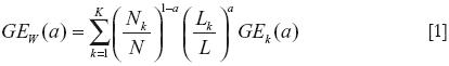
Where N is the total number of individuals, Nk the number of individuals in ejido (k,Lk) the amount of land held in ejido (k,L) the total amount of land in the sample and GEk(a) is GE(a) calculated for ejido k.
Table 2 shows results of the decomposition analysis. The top panel includes all of the ejidos in the sample, while the bottom panel excludes those which do not have any parceled land (in which case each individual's private parcel size is registered as zero).5 In both cases, we observe that the vast majority of the overall inequality in the land distribution of the ejidos is due to variation in the mean parcel size between ejidos, rather than differences which occur because of the distribution of land within the ejidos. That said, however, the mean Gini coefficient within the ejidos is 0.26, and ranges up to 0.83. Inequality in cattle holdings is significantly greater than inequality in land, although some of this is due to the fact that it is not possible to raise cattle in some ejidos.6 If one compares between–jido inequality measures between cattle and land, the magnitudes are relatively similar. Within–ejidos, however, inequality in cattle holding is much greater than inequality in land holding. In cattle holding, it is within–ejido inequality that is the primary contributor to overall inequality. In addition, one can observe that these measures increase dramatically with the value of a of the GE indices. Increases in this parameter correspond to increasing sensitivity to the wealthier part of the population in the distribution. These increases therefore reflect increasing inequality among the wealthy —the implication of which is that cattle holdings are highly skewed, with a relatively few individuals in the wealthiest quintiles holding the majority of the total herd in a community. If the measures are taken seriously as historical versus present, this suggests that regional inequalities have remained steady, while measured increases in inequality result from increases in inequality within communities. However, it is important to keep in mind that cattle are quite a distinct measure of wealth from land. Although the two are related, the productive potential of cattle is quite restricted by regions, which may be reflected in the between–ejido measures. The next section explores the potential sources of this inequality, both within and across ejidos, in the context of the hypotheses developed above.

EMPIRICAL ANALYSIS
This section analyzes the correlates of inequality within and between ejidos, using as the measure of the former the Gini coefficient of the private land or cattle distribution in each ejido (I), and for the latter the mean private parcel and herd sizes within each ejido. The basic specification is a simple regression where inequality is a function of geography (Ge) pre–Colombian population (Pe), and the time in which the ejido was formed (T):

A variety of geographical measures are used to proxy for Ge, including percentage of the ejido with a slope of less than 6 percent, average altitude of the land in the ejido, and a dummy variable indicating whether or not the ejido has temperate forest. For the regressions of mean parcel size, state averages are used rather than ejidal values for the geographic variables. Although fine scale information on soil quality is not available, forest type and altitude control broadly for soil type. Finally, proxies for the timing of the founding of the ejido are its age in 2000, and, alternatively, dummy variables for the periods 1914–1934 and 1934–1950, the peak years of the Reform. Pre–colonial populations are represented by dummy variables as described in the data description section. The equations are estimated using ordinary least squares (OLS) with robust standard errors.
Sources of inequality
Table 3 shows the results of a regression using the entire sample, where the dependent variable is the natural log of mean land holding of ejido members plus 1. This is therefore a measure of between ejido inequality. The hypotheses presented above are corroborated. Ejidos which were founded earlier in the reform have more land per capita, regardless of whether early is measured by dummy variables for 1915–1934 and 1934–1940, the age of the ejido in years, or a simple dummy for before 1940. The fact that there is no difference in the magnitude of the coefficients for the periods 19151934 and 1934–1940 suggests that the supply–side constraints on land did not differ much between these two periods.
Of the geographic variables the most robust result is that less land was awarded to ejidos with temperate forest. Given that temperate forest generally indicates higher quality soils that tropical forest, one might interpret this as support for the hypothesis that less land was given when that land was of higher quality. On the other hand, slightly more land was given in states with more low sloped land, although this effect is only marginally significant.
The presence of large pre–Colombian populations also appears to have a significant effect on land distribution. The coefficient on the Aztec and Mayan regions combined is negative and significant. When we separate out the two empires, only the Mayan region remains significant, and the effect is very large. The magnitude of this effect likely comes from the fact that ejidos in these regions are likely to be those that have chosen to keep all of their land as commons, and hence their private parcels enter the data set as zeros.
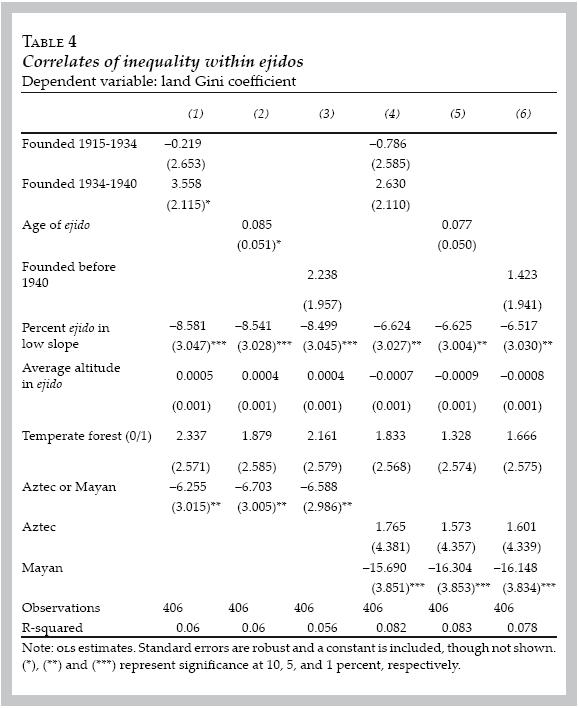
Within–ejido inequality is considered in table 4. Here we observe higher inequality in those ejidos formed in the early part of the Reform, although these results are only marginally significant. The results also show a large and significant impact of land quality on the internal distribution of land —those ejidos with more low sloped land tend to have lower inequality. This is evidence that quality–adjustments within ejidos were made at the time of land allocation, suggesting that the inequality observed in measures of land holdings overstates true inequality in terms of productive capacity. Finally, ejidos located in the Aztec and Mayan states have much lower measures of land inequality, particularly those in the Mayan regions. As before, this is probably due to the large amount of purely communal ejidos in these regions. Finally, tables 5 and 6 consider the correlation between inequality between and within ejidos as measured by a current asset —cattle. Unlike the land data, where there is potential endogeneity between land size and the timing of ejido founding, it seems quite implausible that there is any reverse causality between the date of the founding of the ejido and cattle herd size in 2002. Between–jido inequality is largely explained by the geographic and institutional variables. Larger herds are found where they are more productive —in states with low slope, low altitude, and temperate forests. Much larger herds are also found outside of the Aztec and Mayan regions, with presence in either region having similar effects. The point estimates of early formation of the ejido are positive — indicating larger herd size in early ejidos— but not statistically different from zero. The same is not true when we consider within–ejido inequality (the main source of inequality in cattle in the data). Early ejidos show much greater inequality in herd size. Within–ejido inequality is also higher in places where there is less variation in land quality —within ejidos at lower altitudes and with more low sloped land. Finally, inequality in cattle herd sizes is lower in the Aztec regions and higher in Mayan regions.


This section has examined the correlations of land and cattle distribution both between and within ejidos. This analysis gives us insight into how factors which determined the initial distribution of land have fed through to affect the current distribution of assets. In particular, geographic variables continue to be of substantial importance, but the timing of the land reform —interpreted as the impact of different eligibility rules over time— which was very important in determining between–ejido land allocation, has little impact on between–ejido allocation of present assets, while having an important influence on the current distribution of current assets within ejidos. Presence of dense pre–colonial populations continues to affect the current distribution of assets. The correlations shown here are suggestive support of the hypotheses presented earlier, although in some cases they do not correspond —for example, the observation of higher inequality in current assets among the Mayan ejidos. Because the data do not contain good instruments to predict institutions, it is impossible to separate the causal effect of the institutions which have developed over time on the land and cattle endowments of individuals in our sample. However, examination of summary statistics on the institutional type information present in the dataset can give some insight into the dynamics within the different types of communities. The next section presents this analysis.
Leadership, rules, and uncertainty
This section examines the differences in the concentration of leadership, in rules and in uncertainty over resources which might change investment decisions within the ejidos. Of particular interest are the varying effects of pre–colonial population density and very early ejido foundation on the within–ejido distribution of cattle. Table 7 shows a summary of key institutionally–related variables according to pre–colonial population. Relative to other regions, the percentage of ejidatarios who have been in leadership positions in the past 10 years is much lower in the Mayan region than in either of the other two.7 This suggests a certain level of concentration of power within these communities, and is consistent with the greater with–ejido inequality in assets that we observe in these communities. Ejidos in the Aztec region, on the other hand, exhibit a more egalitarian system of power–sharing within them. Participation in community assemblies, on the other hand, is highest in Mayan regions and lowest in other regions, with Aztec regions falling in the middle.
The next measure is whether or not the ejido contains a zona achurada, or an area in the ejido which the ejido considers theirs but is not officially part of their land allocation. In other words, it measures whether or not the ejido has a land conflict. One might expect less investment in productive assets in ejidos which suffer from this uncertainty regarding their total land area. Achurada zones are most prevalent in the Aztec region, and there are surprisingly few in the Mayan regions. Water conflicts are also very high in the Aztec region. This is likely because this is the area of highest population density in the country —central Mexico. The presence of conflicts over water and land could be interpreted as difficulty in developing the institutions needed to support investments in productive assets relative to the other regions. They also, of course, could simply be indicative of locations with significant water scarcity.
The last three variables in the table indicate whether or not the ejidos have developed rules regarding use of resources from their commons. In all cases the Mayan ejidos have considerably lower presence of rules over any resource than the regions outside the Mayan or Aztec empires. In the Aztec region, on the other hand, there are many more rules governing wood extraction and fewer governing pasture use. The development of rules is clearly endogenous to the presence of resources and multiple other factors. However, the conspicuous lack of rules and the higher political concentration in the Mayan ejidos does correlate with the presence of a hierarchical society where assets and power have concentrated in the hands of a relative few, and is not inconsistent with scholars' understanding of the post–classic Mayan civilization.
Table 8 examines the institutional variables as they relate to the timing of the ejido formation. In particular, it separates out the ejidos which were formed before hacienda workers were allowed to receive land. As was mentioned above, the Reform during this period was focused on the restitution of land to traditional agricultural villages rather than a redistribution of land to workers. The picture that emerges from the statistics is not particularly clear. Post–1934 ejidos have higher participation, less likelihood of a land dispute, and greater likelihood of rules governing pasture use. However, they have fewer rules governing forests and slightly higher political concentration. On the other hand, the greater inequality of cattle distribution that we observe within the earliest ejidos is concordant with a lack of rules governing pasture use.

CONCLUSION
This paper has presented varying hypotheses for the effects of history and geography in influencing the initial allocation of land in the ejidos of Mexico and the present allocation of assets. It has woven a narrative whereby the presence of pre–colonial populations affects the decisions of the Spanish regarding where to settle and develop institutions, and where to set up purely extractive mechanisms. It then examines how these early population densities influenced distribution of land during the reform, and how the timing of the formation of an ejido could have interacted with both historical population densities and geography. The earliest ejidos were different in character from later–formed communities as a result of both eligibility rules and the increasing scarcity of land to allocate.
Data from over 400 forest–holding ejidos is used to examine the effect of these factors on past and present wealth measures. It shows that where pre–colonial populations were dense, there was less private land allocated during the reform and greater equality in these allocations within ejidos. In terms of geography, greater variation in land quality resulted in greater inequality within ejidos, and the less land per person was given to ejidos in temperate zones, which could potentially be more productive than tropical ones. The earliest ejidos received more land, although there is no evident impact of early formation on the within–ejido distribution of land.
Cattle herd sizes proxy for the current distribution of wealth. Given the variation in productivity of cattle across Mexico, this proxy is imperfect. However, cattle tend to be an important asset throughout the country and are present in all of the zones contained in the sample. Consistent with the variation of cattle productivity across space is that geographical variables are important determinants of both within and between ejido inequality. The timing of the Agrarian Reform does not have any effect on the distribution of cattle between ejidos, but ejidos formed before the 1934 revisions of the provisions for the Reform tend to have higher within–ejido inequality. Finally, ejidos located within the cores of the Aztec or Mayan empires have significantly smaller cattle herds, and those located within the Mayan zone have significantly greater inequality within these herds.
The last section of this paper examines the differences in institutional outcomes across pre–colonial populations and year of ejido formation. It shows political concentration and absence of rules regulating commons use in the Mayan region, and instability of property rights in the Aztec region, relative to those ejidos found outside of these regions. The analysis presented in this paper has been largely descriptive, with the data limiting its ability to establish causality. Nonetheless, the correlations are suggestive of the deterministic nature of both institutions and geography in shaping the distribution of wealth within Mexico. Efforts to understand current management of resources and projects aimed at improving the welfare of rural Mexico would do well to take into account the persistent impact of these factors.
REFERENCES
Acemoglu, D.; S. Johnson and J. Robinson, "The colonial origins of comparative development: an empirical investigation", American Economic Review, vol. 91(5), 2001, pp. 1369–1401. [ Links ]
––––––––––, "Reversal of fortune: geography and institutions in the making of the modern world income distribution", Quarterly Journal of Economics, vol. 107(4), 2002, pp. 1231–1294. [ Links ]
Alix–Garcia, J., "A spatial analysis of common property deforestation", Journal of Environmental Economics and Management, no. 23, 2007, pp. 141–157. [ Links ]
––––––––––, "An exploration of the positive effect of inequality on common property forests", Journal of Development Economics, vol. 87(1), 2008, pp. 92–105. [ Links ]
Banerjee, A. and E. Duo, "Inequality and growth: what can the data say?", Journal of Economic Growth, no. 8, 2003, pp. 276–299. [ Links ]
Banerjee, D.; D. Mookherjee, K. Munchi and D. Ray, "Inequality, control rights and rent seeking: a study of sugar cooperatives in Western Maharashtra", Journal of Political Economy, vol. 109(1), 2001, pp. 138–189. [ Links ]
Bardhan, P., "Irrigation and cooperation: an empirical analysis of 48 irrigation communities in South India", Economic Development and Cultural Change, no. 48, 2000, pp. 847–865. [ Links ]
Cardenas, J.–C., "Real wealth and experimental cooperation: experiments in the field lab", Journal of Development Economics, no. 70, 2003, pp. 263–289. [ Links ]
Coe, M.D., The Maya, Thames and Hudson, 1998. [ Links ]
Collier, P. and A. Hoeffler, "Greed and grievance in civil war", Oxford Economic Papers, no. 56, 2004, pp. 563–595. [ Links ]
Cowell, F. and S. Jenkins, "How much inequality can we explain?", Economic Journal, no. 105, 1995, pp. 421–430. [ Links ]
Macours, K., "Comparing a direct with an indirect approach to collecting household level data: who tells the truth?", Mimeo, University of California at Berkeley, 2002. [ Links ]
Mankiw, N.G.; D. Romer and D. Weil, "A contribution to the empirics of economic growth", The Quarterly Journal of Economics, vol. 107(2), 1992, pp. 407–437. [ Links ]
Reed, N., The Caste War of Yucatan, Stanford University Press, 1964. [ Links ]
Sachs, J. and A. Warner, "Economic reform and the process of global integration", Brookings Papers on Economic Activity, 1995, pp. 1–118. [ Links ]
––––––––––, "Fundamental sources of long–run growth", American Economic Review, no. 87, 1997, pp. 184–188. [ Links ]
Sala–i–Martin, X., "The world distribution of income: falling poverty and convergence, period", The Quarterly Journal of Economics, vol. 121(2), 2006, pp. 351–397. [ Links ]
Sanderson, S.R.W, Tand Reform in Mexico: 1910–1980, Academic Press, 1984. [ Links ]
Shorrocks, A.F., "Inequality decomposition by population subgroups", Econometrica, vol. 52(6), 1984, pp. 1369–1385. [ Links ]
Simpson, E.N., The Ejido: Mexico's Way Out, The University of North Caroline Press, 1934. [ Links ]
Smith, M.E. , "City size in late postclassic Mesoamerica", Journal of Urban History, vol. 31(4), 2005, pp. 403–434. [ Links ]
Theil, H., "The measurement of inequality by components of income", Economics Tetters, no. 2, 1979, pp. 197–199. [ Links ]
World Bank, World Development Report 2006: Equity and Development, Washington, D.C., World Bank 2006. [ Links ]
* The author wishes to thank two anonymous referees for their valuable comments and suggestions.
** JEL: Journal of Economic Literature–Econlit.
1 For representative papers from each of these veins of literature see Mankiw et al. (1992), Sachs and Warner (1995), Sachs and Warner (1997), and Acemoglu et al. (2001).
2 In this paper, the term ejido also includes communual properties known in Spanish as comunidades, indigenous communities mostly located in southern Mexico.
3 Land was also awarded to individuals, but as the Reform progressed, this became less common. In any case, our primary concern here is the development of the reform as it relates to the ejidos.
4 An ejido sector reform in 1992, called Programa de Certificación de Derechos Ejidalesy Titulación de Solares Urbanos, allowed for a one–time expansion of ejido membership and redistribution of land. We use the measure of land holdings prior to the 1992 reform.
5 Because of the difficulty in including zeros in the GE indices, calculations are done after adding 1 to all individuals' land and cattle holdings.
6 Interestingly, however, the calculations to do not change significantly when we leave out all ejidos with zero cattle in them.
7 There are generally four leadership positions available at any given time in an ejido, with elections occurring every two years.

