


Serviços Personalizados
Journal
Artigo
 Inglês (pdf)
 Artigo em XML
 Referências do artigo
 Enviar este artigo por email
Indicadores
-
 Citado por SciELO
 -
 Acessos
Links relacionados
-
 Similares em
SciELO
Similares em
SciELO
Compartilhar

 Permalink
Anales del Instituto de Investigaciones Estéticas
versão impressa ISSN 0185-1276
An. Inst. Investig. Estét vol.37 no.107 Ciudad de México Set./Dez. 2015
https://doi.org/10.22201/iie.18703062e.2015.107.2551
Artículos
Seeing Water in Early Twentieth-Century Mexico City: Henry Wellge's Perspective Plan of the City and Valley of Mexico, D.F. 1906
El panorama acuático de la ciudad de México de principios del siglo XX: El Plano en prespectiva de la ciudad y el valle de México, 1906, de Henry Wellge
Stacie G. Widdifield and Jeffrey M. Banister
University of Arizona
Artículo recibido el 7 de enero de 2015;
Devuelto para revisión el 13 de mayo de 2015;
Aceptado el 19 de junio de 2015.
Abstract
We examine Henry Wellge's 1906 chromolithograph, Perspective Plan of the City and Valley of Mexico, D.F., a panoramic view that organizes the capital and its lacustrine environs through close up and distant perspectives. The Plan depicts a landscape integrated by canals, rivers, and lakes, recording a pivotal moment before modern hydraulic infrastructure would remove surface water from view. We thus interrogate this image as a visual register of hydraulic-control ideals in vogue around 1900, as Mexico was politically centralizing resource governance, and reorganizing rural and urban space through the construction of modern waterworks. Wellge's plan compels us to examine water as a relationship between the material and the represented landscape —that is, as a combination of social, spatial, and visual practices and politics through which this landscape and geography have been articulated and rendered intelligible.
Keywords: panoramic city views; Valley of Mexico; Mexico City; Porfirian Mexico; hydraulic geographies; chromolithographic prints.
Resumen
Este estudio se enfoca en la cromolitografía de Henry Wellge de 1906, Perspective Plan of the City and Valley of Mexico, D.F., una vista panorámica que estructura la capital y sus alrededores lacustres mediante primeros planos y perspectivas distantes. La obra representa un paisaje conformado por canales, ríos y lagos, y documenta el momento crucial previo a la estructuración de la infraestructura hidráulica moderna que eliminaría del panorama la superficie acuosa. Por tanto, examinamos esta imagen como documento visual de las ideas de control hidráulico en boga alrededor de 1900, cuando en México había una política centralizadora de recursos, que reorganizaba los espacios rural y urbano mediante la construcción de modernas plantas depuradoras de agua. El plano de Wellge nos obliga a analizar el agua como una relación entre lo material y el paisaje representado, es decir, como una combinación entre la política y las prácticas sociales, espaciales y visuales mediante las cuales este paisaje y geografía se han articulado y representado de manera inteligible.
Palabras clave: panoramas urbanos; valle de México; ciudad de México; porfirismo; geografía hidráulica; cromolitografía.
In 2013, during the course of our ongoing interdisciplinary research project, The Visual Culture of Modern Water in Early Twenthieth-Century Mexico City, we encountered a large-scale chromolithograph of Mexico City from 1906 in the Special Collections Library of the University of Arizona, namely, Henry Wellge's Perspective Plan of the City and Valley of Mexico, D.F., 1906 (fig.1).1 Wellge's panorama belongs to a tradition of detailed and often brilliantly colored images of Mexico City and surrounding environs produced since the colonial period.2 The capital city's unique profile of buildings and celebrated surround of lakes and mountains are easily recognizable, yet at the same time it is a highly conventionalized representation anchored in its obvious grid structure.3 Wellge, a German immigrant to the mid-western United States, was one of a number of prolific and highly sought-after nineteenth-century artists who created this and other city views that were then churned out by U.S. publishing houses to be bought by individuals to hang in their homes. The University of Arizona print was intended for this purpose; it is framed for hanging, and has the original Mexico City framer's tag still affixed to the back. These city views were also distributed for free by businesses and carried advertising information. A second extant version of Wellge's image, for example, was overprinted with information from an early twentieth-century Mexico City real estate company (fig. 2).
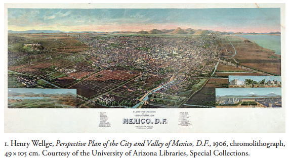
The city is organized on a diagonal grid that emphasizes the historical seat of power, which includes the Plaza Mayor, anchored by the Cathedral and National Palace. Set against this metropolis-in-miniature is Wellge's presentation of a vast sweep of the valley articulated in part by the numerous modern railroad lines, but also, emphatically, by water. He drew from a lexicon of geographic and visual tropes that had directed viewers and readers to imagine the area in particular ways since the early sixteenth century. As much as the valley is conjured by ancient landmarks—the rise of Chapultepec to the west, the Sierra de Guadalupe range to the north, and Lake Texcoco to the east—Wellge's image represents a definitively modernizing Mexico City in which water, so dramatically present in the print, plays a crucial role.
Wellge's image is richly evocative, a dazzling and brilliantly colored landscape as well as a useful, legible picture of Mexico City.4 It hovers somewhere between the centuries-old pictorial tradition of the city-on-a-lake and a new modern, urban landscape fed by a web of highly visible canals and rivers. Indeed, the print was published during the Porfiriato, the well-documented turn of the century period of urban transformation and modernization of Mexico City and its environs, not least of which was a massive overhaul of the water supply and drainage systems, the realm of our project. Wellge's picture is not a comprehensive documentation of these profound changes nor is it an engineer's blueprint of pipes and pumps. It does, however, resonate visually and conceptually with this moment's modern understanding and control of hydraulic resources. Aware of the multiple complexities of this image, we present here an initial exploration of the print as it is entangled with Mexico City and its water. As an art historian and geographer, we understand this as a work of art (and as a multiple), an index of socio-spatial transformation, as well as an impossible view woven out of diverse claims about the "true" nature of Mexico City's geography and art/history at that moment. We are conscious that we leave aside issues that may be of concern to colleagues in our respective disciplines and also that our approach attempts to explain what is in the image and equally uses the image to explain what is not.
The essay is divided into four parts. In the first part, we describe in general terms the history and geography of the valley, and situate the print within turn-of-the-century hydraulic politics during the administration of president Porfirio Díaz. In the second part, we examine what the print shows us and how it was made. We discuss how this particular print technology was able to accommodate, or not, the Mexico City situation. In part three, we examine the relationships between urban development politics, water control, and representationóthe rhetoric (visual and otherwise) employed to persuade the public of the need for and benefits of modern water control approaches. In the final section, we focus specifically on the sociospatial work of water in the print, and in particular its relationship to transformations in the hydraulic landscape.
Porfirian Politics and Hydraulic-Social Transformation
Particularly in late nineteenth-century Mexico City, changes in the relationships between humans, water, and hydrology were keyed to ongoing shifts in ways of being in and perceiving "nature" more broadly.5 As Peter Krieger suggests, the disappearance of surface water is the disappearance of "an essential aesthetic and ecological quality."6 In the early 1900s, the Federal District was bringing on line a modern hydraulic system that would require water to disappear from view both through the desiccation of the surrounding lakes and through the construction of a vast subsurface pipe system for potable supply. This was a pivotal moment in the historical geography of hydraulic politics across the republic, with the federal government asserting control through legal and other means over water resources that previously had been managed at local or municipal levels.
As a large body of literature points out, Tenochtitlan-Mexico City was virtually synonymous with its singular hydraulic foundation, and no description would be complete without paying proper homage to its striking aquatic situation as an acuápolis, as Peter Krieger has termed it.7 Bernal Díaz del Castillo, chronicler of the conquest of Mexico, described Tenochtitlan as a series of "great towns and pyramids and buildings rising from the water [...] like an enchanted vision." 8 As this observation suggests, the evolution of the city—rhythms of daily life, politics of land use and development, modes of technology and urban infrastructure—have long been tightly bound to hydrologic processes in this complex lacustrine environment. However, the two or so decades around the late nineteenth and early twentieth centuries constitute a time of particularly radical and durable socio-environmental transformation. The availability of capital, new forms of technology, and shifts in the worldview of the nation's ruling class combined to create projects for reshaping the earth in unprecedented ways. Capital investment, new technologies, and novel modes of resource governance allowed for a profound reconstitution of urban and national space. Wellge's print suggests aspects of this process.
The city and valley have always been places of striking socio-environmental paradox: some areas might be experiencing waves of water scarcity and rationing while others reel from floods. The largest-scale water solutions early on were developed in response to the dramatic seasonal ebb and flow of water in the lakes. By 1607, laborers under the direction of colonial officials began tunneling through the mountains to the far north of the basin as a way to drain the basin's lakes, check against flooding and modulate water levels across the valley more generally.9 This project was not completed until the early 1900s as part of the Gran Canal de Desagüe (Great Drainage Canal). The Desagüe was both an astonishing feat of human ingenuity and labor and, as Perló Cohen describes it, "a long and deep scar on the geography of the Valley of Mexico."10 At least in theory, water flowing into the city as "waste" (either metabolized by humans or flowing as storm runoff) could now be flushed out of the basin entirely. The Desagüe and other projects like it to redirect water on a large scale dramatically altered historic relationships between humans and the aquatic environment. Critically, their deleterious social-environmental effects necessitated further large-scale interventions as time went on, a vicious cycle that continues in the present.
But while the combination of technology, capital, and human labor allowed for the exit of water out of the valley, it also engineered its flow into the city, albeit in a less dramatic fashion than the large-scale flood-control works. Especially starting in the early twentieth century, the city's built environment began to expand in different directions, ultimately sprawling across the now drying lakebeds and marshes, running up hillsides and over mountain slopes, and paving over and channeling the basin's rivers and streams. In the coming decades, major transportation arteries would be laid over many of the water features that are still visible in Wellge's lithograph. Increasingly, potable water would pulsate through the modern infrastructure's expanding underground capillaries rather than along its colonial-era, largely open-air water system.11 In the latter, water and its infrastructure were visible in places throughout the city, and waterworks such as the Chapultepec aqueduct, left an indelible mark on the city's future development patterns.
Influenced by the emerging discipline of public health and a broader consciousness about the dynamics of disease, however, drinkable water now required enclosure, reversing its historical exposure in open aqueducts, acequias, and public fountains. More specifically, water was disappearing in two obvious ways: potable "clean" water moved underground in the new pipe system and "dirty" water flowed out of the city through the Desagüe, contributing to a change in the human experience of water.
Driving many of the infrastructure projects was an abiding faith in science and technology that permeated politics of the late nineteenth and early twentieth centuries, in particular during the administration of president Porfirio Díaz (1877-1910). Ambitious public works like the Desagüe illustrate elites' desire to tame a natural world that was seen to exist largely outside of their own. This is in part what Perló Cohen calls the "Porfirian paradigm," a widely held elite-official vision.12 Historian Claudia Agostoni traces the connections between officials' ideals of progress, technology, and environmental control and everyday life in places like Mexico City through the development of infrastructure on a scale previously unknown. The Desagüe, for instance, became "a vast socio-sanitary domain," the construction of which "altered the landscape both above and below ground" and as such became a permanent feature of daily life for capitalinos.13 It likewise acted as a vehicle for connecting city residents to the processes of environmental governance and politics. Importantly, the infrastructure developments (including the politics of waterworks projects) during the Porfiriato literally and figuratively laid the groundwork for future water-control approaches. According to environmental scholar, Patricia Romero-Lankao, the Porfirian approach to water
consolidated a centralized state-centered system of water management [...and] initiated a complete modification of the basin's hydrological cycle, whereby rainwater no longer followed the path of infiltration, storage in water aquifers, stagnation and evaporation in lakes—at least not in the same proportions.14
This transformation of hydrology both drove and was shaped by changes in the city's physical and social geography.
According to Wellge's print, in 1906 the greater Mexico City area had around 550,000 inhabitants, a sizable number for the time.15 By 1913 it became one of the first large urban areas in the nation to complete its own modern system (with electric pumps and modern concrete technologies) to deliver potable water. Although competing proposals to address the area's perennial scarcity problem had been in the works since the late 1800s, officials ultimately opted to pump and deliver water into the city center from Xochimilco, nearly thirty kilometers to the south. At that time Xochimilco was still one of the most intact parts of the valley's ancient volcanic lake system, its many freshwater springs forming a critical element of the region's hydrology. This was also a place where indigenous cultivation had long flourished, based on a "floating garden" system of cultivation, or chinampa agriculture. The purity and consistent flow of Xochimilco's luxuriant springs made them an obvious source of water for the growing city, as we discuss below. Nonetheless, hydraulic extraction would also come at an extremely high social and environmental cost, in particular for the southern area's inhabitants, who at the time were producing much if not most of the city's food. As some contemporary observers also pointed out, drawing from the springs would probably take water out of the Canal Nacional, a major transportation waterway linking the city center to the basin's southern end, and a primary source of water used for washing out the city's drainage network. The Canal drew its water from the same system of springs feeding Lakes Xochimilco and Chalco.16 The Xochimilco system was in operation for scarcely longer than two decades before the springs were severely depleted, with Xochimilco's ecology showing signs of distress.17
Technological transformation moved in parallel with the centralization of hydraulic-social regulation in the hands of government officials, either within the Federal District or in one of President Díaz's cabinet-level ministries. According to historian Luis Aboites Aguilar, expanding federal regulation of water began to conflict with "local traditions, superimposing the weight of an external, alien bureaucratic authority [that became] an inevitable protagonist in local life."18 A raft of new legislation provided the juridical means to appropriate water sources by claiming, in the name of federal government, the territory water flowed over, under, or through. Chief among these was the 1888 law on vías generales de comunicación (loosely, the law on boundaries and waterways), which significantly increased the Federal District's authority and territory to assert a regulatory control over surface waters. Now, any body of water that was "flotable," navigable, or that constituted an international or state boundary could feasibly become part of a federal water concession and be subject to federal regulation. For many, this was an astonishing challenge to local autonomy. Before this time, water use and control had remained squarely within the realm of civil law and municipal authority. The new laws, however, allowed the Federal District to appropriate hydraulic resources throughout the basin and later from other basins at exactly the same moment that its power and spatial reach had been greatly increased with promulgation of the 1903 Law of Municipal Organization. Ayuntamientos (city councils)—heretofore relatively autonomous elected bodies—now found their ability to govern greatly curtailed by the new federal structure. "Real power," according to Lear, "passed into the hands of the Superior Council [...] of the Federal District, which consisted of the governor, the president of the Council of Public Health, and the director of general public works, all offices appointed by President Díaz and funded by the federal government."19
The Federal District was also expanding more or less in inverse proportion to the surface area of the lakes on which the city had been originally founded and built. Even though, as Wellge's lithograph suggests, at the turn of the century this was no longer an island city linked to the mainland by causeways, as it had been during the Aztecs' reign into the early-to-mid colonial period, it was still a profoundly hydraulic place. The Porfirian approach to water control both accelerated and moved in new directions a process of political and infrastructural transformation that would fundamentally alter this hydraulic character. The representation of "water" and "society" was not and is not ancillary to this process; rather, it resides at the very core of the city and basin's dramatic hydraulic transformation.
The Image: Accommodating the City, Valley, and Federal District
Wellge (1850-1917), a German émigré to the Midwestern United States, was a major contributor to the economy of the nineteenth-century panoramic city view. Henry Wellge made and published these bird's eye views into the early twentieth century. As the Amon Carter Museum notes, he produced more than 150 city views in twenty-six states as well as in Quebec.20 No published inventory of his works, however, lists the Perspective Plan of the City and Valley of Mexico, D.F. At this point in our research we do not have any information about how and by whom he was commissioned to make the Mexico City view. It is possible that the commission came as the result of the mid-west/Mexico City connections established within the American Colony in the capital around the turn of the century.21
Wellge constructed Mexico City from the components that he and his contemporaries used to make the hundreds of nineteenth-century commercial chromolithographs of Chicago, Milwaukee, Los Angeles, and Fort Worth, among many growing urban centers. His print is built from the typical component of a horizontally-oriented primary image, text, vignettes, and a white border space.22 The primary image represents a specific city space with a variety of its recognizable landmarks laid out across a horizontal sheet of paper. People are largely absent from these views, effectively emptying them of the local, anecdotal elements and popular social types that characterized nineteenth century genre painting and lithography in Mexico. Instead, the built environment and new construction are highlighted. Text may appear in the print identifying particular objects or in the border where it may or may not correspond to specific objects in the print. Vignettes are smaller, secondary images that may be placed within the primary image itself or around the outside border to insert decorative elements, to emphasize in greater detail material that is not easily discernible, or, to present material not in the print at all.
These panoramas also traded on traditions of nineteenth-century high art landscapes with their painted, sweeping horizontal views. The development of more sophisticated chromolithographic techniques perfected in the second half of the nineteenth century, not to mention brilliant inks, aided artists in creating both a more painterly and what was understood as a more natural-looking landscape effect. The artful enhancement was, no doubt, appreciated by the buying public, and provided a less expensive approximation of an oil painting, which was often framed for hanging in domestic interiors. As mentioned previously, the version of Wellge's print with which we are working was indeed framed and on the back bears the Mexico City framer's label.
The production technique of the print was fairly standardized. The artist first created sketches as he walked through the city, block by block, experiencing it first hand, and he likely did so with the aid of an existing city street plan. This very detailed view would be the visual, if not exact compositional, center of the print. The artist then drew up a rigid grid—the organizing armature—on which were imposed the sketches. The space of the city—the panoramic vista—could be adjusted by compressing or expanding the distance between the orthogonals of the grid.
While the city view is a capacious medium and allows for an information-dense image, it of course cannot capture fully what the print claims to represent. Different from many of his American city views, Wellge's Mexican panorama had to accommodate three interlocking subjects within one picture, a much bigger picture than a single, clearly defined urban center. As the title text declares, we should see: the city, valley, and Federal District of Mexico, that is, the entorno, the broader historical and political geographic dimensions. This means he had to accommodate: 1. a large, densely built city, itself organized around a grid that expands from the nation's historical and political center in the Plaza Mayor; 2. an immense basin entirely sealed by mountain ranges, integrated by visible surface water features (canals, wetlands, etc.), oriented relatively north/south, and longer than it is wide; and, 3. an administrative unit, the Federal District, which is both a bureaucratic actor, and a map of the municipalities it governs. How does the print accommodate all three?
The city itself takes up almost half of the space. It is laid out across the diagonally set grid that allows Wellge to stuff in the maximum number of buildings, as well as railroad lines, factories, and fountains whose placement is based on his apparent knowledge of the compact urban environment. The grid is compressed, indeed, sucked violently to the upper right, or northeast,where it fades into the foothills of the Sierra de Guadalupe mountains.The visual focal point is the Plaza Mayor, or Zócalo, which is signaled by the two-towered cathedral facing south. Typical of his city views, Wellge did not label any of the buildings themselves. Text in the border space tells the viewer what would be found there, including among other things modern urban amenities, major institutions, and railroads.
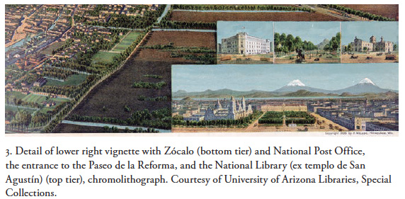
He supplements the city view with the vignettes, miniature views placed in the lower right corner of the print to emphasize the Plaza Mayor and Mexico's modern urban culture more generally. The lower vignette contains two tiers of images; in the lower tier are the Plaza Mayor with the Cathedral to the left (north), and the National Palace (east) (fig. 3). In the distance is the mountain chain crowned by the famous and majestic snow-covered volcanoes of Iztaccíhuatl and Popocatépetl. These are traditional geo-historical tropes that define the valley's southeastern border and are so intertwined with the city's identity that they are inserted in Wellge's image in spite of the fact that —as a Google Earth photo would show—they cannot actually be seen from the point of view established by the vignette. In the upper tier of vignettes are diminutive images of the new National Post Office, the National Library (former church of St. Augustine), and the entrance to the Paseo de la Reforma, which symbolically opens onto the elite subdivisions that at the time were in different phases of development and construction in the south and west.23
Despite the plentitude of specific visual information about the city, Wellge's color palette diminishes it over all. The buildings are washed in pale pastels, as if seen through the radiance of the day's beautiful weather and the valley's transparent air; indeed, the Plaza Mayor is so drained of color that it is almost ghostly. This claustrophobic mass of hundreds of structures becomes a shimmering, sunstruck relief, punctuated by the emerald greens of its many parks and trees.
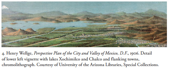
The valley (actually, a closed basin) of Mexico appears in part as a function of the print's horizontality, forcing the viewer to scan from side to side. However, the valley is much longer than it is wide, and the vertical axis should be part of the picture. It is marked by two traditionally represented prospect points, the western rise of Chapultepec hill and the slopes of the Sierra de Guadalupe range in the north. Together these constitute the valley's east/west and north/south vectors. A third, Lake Texcoco, would be visible from Chapultepec, which we see on the upper right side of the print. From the Guadalupe range the southern range of hills and volcanoes would be visible which are, in fact, not in the image. This means that Wellge's image cannot accommodate the southern edge or fourth wall of the border, rendering the valley visually incomplete. The missing border is replaced by the structure of the panoramic print itself: the expanding grid that undergirds the city, thinning out as it descends south- and westward. We could say that the city and its hinterland literally descend, sloping precipitously as the grid draws them downward. The result is that the valley is amputated by the edge of the print itself, stopping short at the white space of the border. Similar to the Plaza Mayor, the south appears in a vignette, and as a supplement to the valley landscape.24 In the lower left, a tiny landscape amends the print with Lakes Xochimilco and Chalco, and the cluster of towns that flank them. Popocatépetl is properly visible in this image as well (fig. 4).
Wellge's valley is more than this truncated axial/visual construct; it is very much made of the pictorial element that competes with it, namely color. While the city was drained of color, so the broader landscape is absolutely drenched in it. The same emerald greens of the park spaces in the city infuse the deep, loamy browns of the plotted lands to the south and west. This picture of fertile, productive ground receives the same warming sun that stripped the city of its pigment, and made of it a virtual backdrop for the trees and shrubs growing in its midst. The bright, almost neon blue webbing of rivers (very vivid when viewed in person) and canals gives the sense that one could circumnavigate the entire field of view. This is repeated in the vignette, whose diagonal grid of blue waterways in the foreground and lakes in the background appears almost as a watery mirror image of the larger print.
Wellge's large display font proclaiming "México, D.F." centered in the white space below the print would logically prepare the viewer to easily recognize the presence of the political entity. As a bureaucratic entity that enacts and acts through paperwork, however, this would be hard to show and see. If we tally up the names of its municipalities, most of the territories comprising it are distributed across the landscape in type requiring a magnifying glass, including those in the southern valley labeled in the vignette. We might think of the entity of the Federal District as made present by this text, in a way similar to the bureaucratic and document-based nature of this political unit itself.
Water Control and Infrastructure in the Life of the City
The rich brown plots of land clearly depicted as available for development in the lower half of Wellge's print constitute the leading growth edge of the city to the south and west. This urbanization would not have been possible without the newly enhanced power of the Federal District, most especially in the area of water supply and drainage. Equally important, however, were their representation within material and discursive practices. As a territorial expression of political authority, the district was growing in strength by effacing longstanding distinctions between city and valley, between Mexico City proper and the many municipalities that the valley encompassed at the time. Contained within it was a claim to the effective control of people, resources, and places valley wide. Though the D.F. was formed in 1824, its geographical boundaries were reconfirmed and its political-administrative powers significantly fortified by the 1903 laws aimed at curtailing the traditional autonomy of local municipal councils. This move would prove decisive for ensuring potable water and drainage for the city's emerging middle- and upper-class urban developments, especially since, as often as not, their modern amenities came at a high social and economic cost for communities elsewhere in the valley (by the mid-twentieth century, the df's reach would extend well beyond that).
In this section we extend Perló Cohen's "Porfirian paradigm" to encompass more broadly the politically contentious spatial strategies employed not only to ensure the valley's drainage but also to secure a supply of potable water, and to include the changing means of representing this process. New technologies and approaches to urban development would increasingly remove water from view, and it would be the task of such things as beautifully designed, palatial pump houses and handsome photographic albums to provide a new visibility, to situate capitalinos within new understandings of hydrology and society, and the connections between these.25 For a growing number of people, particularly the communities in and around Xochimilco, these novel approaches also would mean the destruction of ways of life and livelihood. The visual rhetoric thus became a way to persuade the broader public of the need for and benefits of this modernity and its absolute novelty, even in the face of the many ecological and social uncertainties that the new infrastructure projects came with, and the exploitation and destruction they would later produce.
As Perló Cohen suggested, the "Porfirian paradigm" operated on the assumption that the new water system would expand efficiently and would be entirely modern—using the same technology as London or New York, for example—and would thus supersede technologies of the preceding or existing structure.26 The fallacy here, of course, is that modernity by no means simply replaced what came before; rather, it evolved as a tense articulation of history, geography, and technology. "Modernity," in other words, came in part as a repackaging of what came before.
This repackaging can be viewed in the city's relationship with its lacustrine environs. Using studies carried out by Orozco y Berra, Alcocer, and others, for instance, researching in the 1950s Bribiesca found that many of the city's basic neighborhood outlines could be linked to agglomerations of chinampa fields separated by canals. Moreover, well into the colonial period, many of the city streets were what he calls dobles, a parallel course of canals and roads.27 Wellge's lithograph suggests the extent to which this articulation of hydraulic infrastructure and city landscape remained in place during this period of fast-paced change. The Canal de la Viga, with its parallel calzada depicted in the lower right quadrant of the print, is a primary example of this connection, illustrating not only the parallels between "new" and "old" infrastructure, but also their intersection.
Leading up to the moment in which Wellge made his view, observers throughout the nineteenth century had been attuned to the morphology of the colonial system in the landscape and also to what that morphology allowed them to see of the valley's hydrological cycle: seasonal fluctuations, cycles of flood and drought, contamination and water quality problems. While the city's history is nearly always discussed in terms of its hydraulic dimensions, understanding the seasonality of surface water adds complexity to and even challenges this general understanding. Observers were often acutely aware of the vicissitudes of living in a hydraulic city.28 This was in part a function of the colonial-era structure of water control and provision that the modern system was intended to replace. Like the Porfirian approach, the colonial infrastructure was designed to bring water from outside the urban boundaries and export runoff and wastewater out of the basin. However, the colonial infrastructure was comparatively open to the elements and, as a result, arguably made water a more visible and sensuous part of daily life, most notably in and around the complex of aqueducts and fountains. On a more basic level, its architecture also formed several important strands in the city's urban fabric, making it, therefore, also an important part of urban life.
Oftentimes, the observations were tinged with nostalgia as well as alarm at the effects of human endeavors to transform the basin's geography in the name of water control. Many worried about the wisdom of draining the lakes and canals as part of official policy. At the same time, they expressed a resignation that this was necessary for the security and prosperity of the capital. Alexander von Humboldt and Fannie Calderón de la Barca, two nineteenth-century observers, among others, drew connections between deforestation in the hills ringing the basin, and dramatic fluctuations of lake levels and in the volume of flow in the many springs that supplied the urban population.29
These writers frequently commented on the presence of the colonial period water system, especially the aqueducts and fountains, impressed with the monumental scale of what remained. Yet they also expressed angst over the dismantling of this infrastructure by city workers. This dismantling began more or less in the mid 18th century and continued on in a piecemeal fashion into the late 1800s.30 As with every large-scale water solution that has followed, the colonial system was hardly capable of matching the supply of potable water and protection from floods with population growth, and keeping up with the city's many and complex water problems constituted one of, if not the, primary task of urban governance.31
Water scarcity and poor quality were the constant scourges of urban life, in particular for poor neighborhoods. Following independence, in 1821, there were around 769 private and 42 public fountains servicing Mexico City, and these were tied to two primary aqueducts, one from Chapultepec, and the other from the Desierto de los Leones and Santa Fe areas, in the southwest.32 There were likely around 400 mercedes de agua (water concessions) around this same time, which, according to Bribiesca's calculations, would have directly serviced around 500 out of a total 8,000 structures. In other words, only a small handful of city elites enjoyed a direct connection to the water grid.33 Public fountains in particular thus became critical sites of social interaction across class, ethnicity, and other lines of difference. Everyone needed water and for every conceivable need, and wealth and status by no means simply ensured a consistent, high-quality supply.
As archival documents show, water scarcity as well as industrial water use and contamination became increasingly common themes towards the late nineteenth century. By the time of the publication of Wellge's lithograph, these were a constant source of conflict between industrial elites, city officials, and neighborhoods. The large number of smokestacks represented in the lithograph to some degree suggests the extent to which life in many of the city's colonias and barrios was affected by the growth of industrial production. Even if factories provided their own steam power, many were situated to take advantage of the basin's arroyos and rivers for waste disposal and motor force. In 1907, for example a large group of people in the area of San Ángel complained bitterly that a nearby factory was using far too much water, adversely affecting the community's supply. They had written on several occasions, saying that if officials didn't do something to address the problem soon, "we will be finished by this ruin that threatens us."34 The ayuntamiento, however, was increasingly mired in litigation having to do with water conflict, and industrial elites were a powerful and well-organized force. Indeed, during the late 1880s several factory owners had taken their case to the Supreme Court, arguing that the ayuntamiento had no right to take waters from the Desierto de los Leones aqueducts in the name of "public utility," especially without providing some kind of indemnity. Nonetheless, the companies' lawyer was well aware of the generalized nature of the city's water woes and, perhaps seeing opportunity in struggle, also proposed an alternative scheme.35
For so many, city life during this time was increasingly characterized by a daily struggle to secure fresh water in a context of generalized scarcity. This affected even the privileged classes, though of course they had resources that so many residents lacked to find a potable supply. In 1901, for example, elites living in the many mansions encircling the Alameda in downtown's Mexico City were experiencing an ongoing water shortage, and they vociferously demanded that authorities grant them use of public fountains. The city finally ceded permission, but with the caveat that people could obtain water only after the park had been sufficiently irrigated.36 These are but a few of the many hundreds of cases of water conflict recorded in the files of the Archivo Histórico del Distrito Federal.
While the ayuntamiento had over a long period of time slowly installed a sizable network of lead and clay pipes all over the city, the colonial-era aqueduct system, repaired and updated throughout the years was, even in the early twenthieth-century, still the primary source of potable water.37 The near absence of the monumental colonial era architecture of the water system in Wellge's print is therefore striking. He included not a single fragment of the many aqueducts that had played such a prominent place in the history of Mexico City views. It is all the more striking because the human-infrastructure networks of aqueducts, fountains, acequias, and the small army of personnel charged with their upkeep and regulation, was still critical to daily life in the city, despite the emergence of modern approaches to water control. The absence of colonial waterworks is, on the other hand, also somewhat to be expected, for the new urban developments, with their ostentatious water features, were largely in the planning and speculative stages. Likewise, a new supply system—the obras de provisión de aguas potables de Xochimilco—was at that time just getting underway, a smattering of sketches on engineers' drawing tables.38
New Urban Developments and Seeing the Hydraulic Future in the South
Those new developments are highlighted in the second overprinted version of Wellge's image mentioned above. Typical of the many nineteenth-century panoramic views of American cities that he and his contemporaries made, this version was overprinted with commercial information. No longer merely a framed, mechanically produced picture aspiring to the visual conceits of the painted high art landscape, it is now an advertisement. In this edition of the print, red block letters appear on the white border area, proclaiming to the viewer that the panorama is a "Gift from the Colonia Roma Sur, S.A." In the lower border are details about land purchase prices and the promise of modern amenities. The red lettering shouts to the viewer: look at the bottom half of the image! Look at the urban growth edge to the south and west! The advertising assumes a leading role in directing the viewer's attention, pulling it visually from north to south, top to bottom. In the framed version we have been discussing, the practicalities of city view production, paper size, and printing technique resulted in a picture that looked incomplete, slashed off at the bottom (southern) edge. The compositional cutoff in the second version works differently: it becomes the city's urban development edge. No longer just unfinished visual business, the edge resonates with the possibilities of opportunity and growth to come. The rich browns of plotted land, the bright greens of foliage-lined avenues, and the brilliant blue of rivers and canals, now constitute a pitch to potential investors.
Roma Sur, we are told, is a "choice neighborhood," where you will find all of the amenities at good prices: "[m]odern urbanization (asphalt streets, sewer system, abundance of water, wide sidewalks, park, and trees)." Of course, we now know that drinkable water was in fact quite scarce, and that when and where it was available, it was likely of very poor quality. Indeed, the kind of real estate expansion and investment touted in the commercial version of Wellge's lithograph was not possible given the city's hydraulic structure at the time. Mexico, we are also told, is a great nation, its capital among the great cities, and the tidy and fertile space of the south and west epitomizes the "epoch of progress and prosperity" into which Mexico has purportedly come. Moreover, "The City of Mexico is growing at an extraordinary pace and real estate value is increasing. And this is not by chance. It comes with capital investment, public improvements, and general well being." Indeed, this was not by chance, for these up and coming contiguous coloniasóRoma, Roma Sur and Condesaówere well planned. Roma Sur was one of the subdivisions to which elites were moving from the colonial center.39 The particular importance of the contiguous colonias of Roma, Roma Sur, and Condesa, is signaled by the labels Wellge wrote to identify them in his print. These are the only three he labeled, even if the letters are so small that they require a magnifying glass to read.
The new colonias were an expression of the clout enjoyed by the financial and political elite—Mexican, American, and European—and its proximity to political power.40 Government land concessions and modern services presupposed at least partial recovery of public investment through taxes and fees, which of course only the wealthy could afford. Land development in these areas thus brought together some of the finest engineers and experts that money could buy to construct water and drainage systems and other modern amenities. Other parts of the city, especially to the east of the city center, were much less well planned for future growth and lacked all of these markers of modernity, resulting in a "pattern of great inequality between sections of the city and a redefinition of geographical class relations."41 Growth along the eastern flank was occurring in a far less deliberate way, an area as much settled as planned. Increasing land prices and rents, combined with government policies, were forcing the urban poor out of the center and into the east, south, and southeast. While these were also areas of heavy land speculation, they were not the targets of elite high finance and engineering that the western colonias had become.42
In Wellge's plan, the viewer sees at least some of the distinctiveness of this eastern urban growth. This zone includes his depiction of important modern infrastructure such as the penitentiary, a major railroad hub, and the Desagüe channel, aligned in a visual corridor, or, perhaps more apt, a border. The farther one's eye moves right, toward the city's northern and eastern edges, and toward the receding shore of Lake Texcoco, the less developed the land. Indeed, for much of that large space of marshy and saline soil, there are no obviously plotted residential lots, unlike in the new suburbs emerging in the south and west. In the latter area, Wellge's green spaces indicate planning, water, and growth, not only by their presence but also by their orderly arrangement around canals, streets, railroad lines, and in parks. In the eastern section this pattern becomes more random as trees are increasingly scattered across the land, moving towards the lake edge. Yet, we know that development is occurring. Water and drainage came slowly to these areas in large measure because of the city's requirement that their residents pay for them up front, pointing to differential access to water. This was in contrast to the situation in the south and west, where the government was beginning to throw its resources behind infrastructure development with few or no up front charges.43 In terms of potable services to the former area, people were often forced to derive their water from public fountains and faucets or ambulatory vendors, as had been the case since the colonial period. A typical example of this was the town of Tlacopac, on the Río Guadalupe. In 1907 the town's main fountain had gone completely dry, while local businessmen and agricultural elites were requesting permission to divert the river. Townspeople had "complained bitterly that they could not irrigate their gardens or address the lack of this element so necessary for life." The ayuntamiento issued orders for the fountain to flow once again, so that people could take water from it, but not for their gardens.44
In stark contrast, the developers of Roma Sur's northern neighbor, colonia Roma proper, had commissioned a large, ostentatious fountain from which would radiate the development of the subdivision; it, and its powerful jet of water, were a symbolic and geographical center. This is clearly present in Wellge's print and in period photographs.45 The fountain was not only beautiful but practical, the visible eruption of a steady stream of potable water and a foundational modern amenity for this new community. The Roma fountain, however, is more than an emblem of this colonia. It indexes a way of seeing and comprehending water, of suggesting a future of abundance in the face of current scarcity. Somehow, the city's undeniable water problems would be solved, and development would continue, unhindered. Although it is located in the bounded land of the colonia itself, the fountain is indistinguishable from all other active fountains in Wellge's print, whether modern or colonial. Roma's fountain is no different from those in the historic Alameda Park, in the city center. We can certainly attribute this in the first instance to the artist's use of a standardized image of a fountain, eternally spouting a dazzling jet of foamy, sun-sparkled blue water. Yet, in the context of turn-of-the-century understandings of water, the Roma fountain and all others in the print are also embodiments of what Romero calls the "supply" approach whereby water is presumed to be inexhaustible, no matter how far away (geographically, as well as politically and socially) its original source.46
The inexhaustible source of high quality water capable of feeding Mexico City would have to come from beyond the lower, southern border of Wellge's depicted geography, expansive as it seems to appear, namely, from Xochimilco. The many springs feeding lake Xochimilco in particular had long been considered a possible source for the expansion of the potable water supply. Xochimilco was perceived as being, and continues to be, outside of the space-time of the city. It was more indigenous, rural and traditional than any other area, and a site of rich and productive chinampa agriculture. Its fields were irrigated by luxuriant springs, grandes manantiales whose easily accessible waters were coveted for their quality. The certification of Xochimilco's water as both ample and hygienic was effusively pronounced by Dr. Antonio Peñafiel in his 1884 government study, Memoria de las aguas potables de la capital de México. For many, his pronouncement about Xochimilco's waters was as good as official.
Peñafiel's training prepared him well to assemble this authoritative study on Xochimilco's potable water, but his efforts are also suggestive of a fundamental tension of the times. In preparing his ultimately enthusiastic and convincing recommendation for the takeover of Xochimilco's spring system, Peñafiel had to respond to the problem that modern water control always sets before us, how to represent its literal and figurative abstraction. To do this, he had to navigate between two ways of comprehending and describing. The first, for which his statistician's work prepared him, was to abstract and quantify through a series of diagrams, charts, taxonomies, and formulae, providing flow rates, chemical analyses, etc. The second, for which his deep interest in archaeology certainly prepared him, was an experiential sensitivity. As he argued, water had to be understood "organoleptically," as an amalgam of taste, smell, color, feel, and clarity. 47 But he also moved his analysis of Xochimilco's water into the broader arena of the city and valley of Mexico. For example, he adduces the effects of deforestation around the valley through statistics: the cutting of trees for construction, industry, and cooking was contributing to the desiccation of many water sources, one of whose consequences was severe flooding in the rainy season. Indeed, groundwater extraction would continue for some time to oscillate within a vicious cycle of aquifer overdraft and deforestation. A 1905 report to the ayuntamiento, for example, noted that the wood-fired steam pumps at Chapultepec had not ceased for the entire month of August, consuming an astonishing 444,839 kilos of firewood!48 By contrast, Peñafiel pointed to the vast quantity of leafy cypress trees one could see growing in Xochimilco, a strong index of the abundance of water and the health of the surrounding environment. In the same way, the health of a local spring could be measured in part by its ability to sustain proper and varied species of flora and fauna. 49
Peñafiel's picture of Xochimilco's spring system was a function of different points of view, not unlike Wellge's construction of his plan of the city, valley and Federal District of Mexico. Neither of them can be said to be complete, and the very methods for making information present appear as part of the picture. In Wellge's print, the distant view is a function of his constructed grid structure while the close up street-based portrayal of the city itself was based on what we presume to be at least some experience of walking through it. Attempting to capture these irreconcilable vistas, Wellge's print ran out of room and could not even include the full territory of the Federal District that the print's title suggests it does. In much the same way, Peñafiel's distant and proximate views, the abstracted data versus the accounting of sensual qualities of Xochimilco's water, could not capture the full scope of the spring system or of Mexico City's water problem. This organoleptic assessment, the result of such close observation, as with Wellge's print, largely misses some of the most intimate details, including people and water users. It is remarkable that despite a demonstrated grasp of interrelated social and environmental processes, Peñafiel and his contemporaries did not, perhaps could not, see what Xochimilco's springs might (and indeed did) look like after a few years of heavy groundwater extraction. A little over two decades following the system's construction, the springs were failing, in part the result of this modern myopia and tension.50
As much as Wellge's view is an obvious and necessarily quite partial construction, for us it is suggestive of the very real contemporary spatial and political issues of the water problem of that moment. To understand this we may turn finally to the vignette in the lower left. As noted above, vignettes were typically arranged in these panoramic city views to decoratively embellish the main image, or to depict what was difficult to discern, or not even present.51 Wellge, as we noted earlier, included in the lower right a view of the Zócalo (the Plaza Mayor), as well as significant monuments not visible in the print, that collectively affirm Mexico City as urbane, cultured, and modern. The vignette in the lower left is neither decorative nor does it reference any aspect of the city. It is a miniature view of the southern section of the valley not present in the main image. The south appears as an expanse of lush green fields intersected by multiple canals and rivers, flanked by the remnants of the southern lake system. Behind it is the section of the volcanic mountain range that rings the valley. Lakes Xochimilco and Chalco, and the towns of Tacubaya, Mixcoac, Coyoacán, San Ángel, and Tlalpan are named in Wellge's tiny labels. With great economy of means, this image shows us a picture of the south as a region saturated with what scholars and planners were by then beginning to understand as easily exploitable waters. It also shows us the southern municipalities now controlled by the Federal District that are not visible in the main image. This is where the urban development dynamo of the southern colonias is also inevitably heading, and the direction in which the main print's precipitous lower edge implicitly, perhaps inevitably, points.
Wellge's dramatically compressed representation of the missing southern section of the main print simultaneously brings into view this crucial hydraulic region and the mechanism of its control, namely, the Federal District. We might see this vignette more usefully as a kind of visual annexation of the terrain of the Xochimilco springs, so compellingly nominated by Peñafiel for Mexico City's water solution. The springs themselves are not represented, but at the moment of the print's creation, the Xochimilco system was under construction. The vignette's relationship to the larger whole of the print and the southern region's relationship to Mexico City and the Federal District is an expression of a picture that can never be complete, and a water system that cannot and never will completely satiate the demands of its users. As Wellge's vignettes must supply additional visual information, water from increasingly distant sources—certainly not inexhaustible—are called upon to supply the metropolis.
Conclusion
The subject of Wellge's print, the City and Valley of Mexico, D.F., presents a perpetual problem of vision. From which prospect point can you see everything? Multiple nineteenth-century narrators, for example, describe their view from the heights of Chapultepec. As they try to see the totality, their vision swings from the buildings of the city to the familiar landmarks of mountains, volcanoes, and lake, from east to west and north to south. Their lines of sight mark out an invisible grid across the landscape. Or, from the hills of the Sierra de Guadalupe range, for example, nineteenth-century Mexican landscape painter, José María Velasco, arranges his vast southward looking landscapes of the Valley of Mexico with the aid of photographs and the diagram of the grid.52 So, too, as we have seen, Wellge's print works through its own devices of arrangement and containment. The conceit of any of these representations is to declare present the plentitude of the space depicted. They enable the conjuring effect of the panoramic view.
The other device operating in this representation of the Valley/City of Mexico is its water, which was not intended as the print's primary subject but takes on great significance. The picture of water is both dramatically, visually present and, of course, incomplete. How well the inclusion of the Xochimilco vignette works to expand the picture of water. The tiny vignette pretends to fulfill expectations about what the valley should look like and it creates a tidy package of water. Peñafiel's totalizing scientific abstraction of Xochimilco also contributed to this convenient packaging of water and ultimately helps lead the way to the construction of a system that would organize the space of city/basin in a new way. Highly conspicuous in Wellge's print, water would soon become far less visible in daily life by dint of the engineering initiatives like the desagüe and the Xochimilco projects, designed to meet the immediate needs of Mexico City. Certainly, the future hydraulic geography that authorities wished to control would expand well beyond the capabilities of any vignette to depict it. The modern system produced and emerged through a profound semiotic shift. This shift allowed for the deterritorialization of water, its abstraction and extraction. Yet, as we can see in both Wellge and Peñafiel's examples, water could never be fully abstracted from its historical geography.
This is a combined problem of representation and spatial transformation that of course continues into the present. Since at least the 1990s, Mexico's many universities, government agencies, businesses, and environment-focused ngos have struggled over how to sustain water supplies in the face of a rapidly changing climate by approaching river basins as "integrated" ecological and social units.53 However, depicting a complete river-basin view—creating a full, synoptic picture of the diversity of places, people, and hydraulics that a given hydrologic basin brings together—is no more possible today than it was in the time of Wellge or Peñafiel. Ironically, as El gran reto, a recent comprehensive study of Mexico City's water history shows, the persistence of the water problem and attempts to manage it comprehensively only make this more apparent.54
In 1999 a renowned Mexico City architect, Felipe Leal, along with several others, called for a concerted effort to restore the lake Texcoco area, on the basin's east side. It came as part of a larger and quite controversial proposal to build a new international airport there (canceled in 2000 but by 2014 once again in process).55 Leal situated the Texcoco proposal within a larger vision for the region. "The hydrological restoration of the Basin of Mexico," he urged, "is [also] a re-encounter of the city with its geography, its history, and it is probably the only possibility for guaranteeing [the city's] future."56
Like Wellge's view, however, Leal's assertion requires the aid of a prospect point that is impossible to create. He cannot realistically conjure the same possibilities as Wellge or Peñafiel because he also must deal with the historical and geographical effects of decisions made in turn-of-the-century Mexico and since. He is living in a different time and place of water control and representation, at once tied to theirs and, of necessity, different. As Boehme suggests, once the course of water is altered, it assumes "new destinations and cancels out [...] alternative developments."57 A hydrological picture of the basin in Wellge's day had to include the ubiquity of water at least to some degree as it actually existed in the city and valley. In the present context, water is not nearly so visibly present or obvious, and it comes from much farther away. Representing such a complex physical and social geography is therefore even more difficult. For Wellge's print and Peñafiel's study, the future was in the near distance of the southern valley. Since that time, the great geographic expansion of Mexico City's water control and provision makes the Porfirian vision seem modest.
Leal envisions a secure future as a return to the hydraulic geography proper to the basin. But, it is impossible to grasp in any sufficient detail the vision of hydrology that we are being asked to return to. As a consequence, the places and histories that we would encounter as a result of this return and restoration cannot be conjured. In other words, there is no going back to an originary hydrology. The great paradox is that contemporary projects proposed to restore water—admittedly, in very compelling ways—to the urban landscape are as much about mourning the past as engineering something for the future.58 The most monumental project is, of course, Texcoco Ecological Park, which is planned with multiple goals and users in mind.59 An equally poignant proposal was made by the innovative Mexico City urban design firm, Taller 13, in 2010. They proposed the restoration of a section of the Río de la Piedad river to public view, one of many rivers covered over for both sanitation and transportation infrastructure in the mid-twentieth century.60 The plan envisions the river very concretely and one might say, almost therapeutically, as accessible from multiple vantage points above and at river level. The Río de la Piedad, which today a Google Earth photo would show to be invisible to the eye of the city dweller or the satellite, is the same brilliant blue river so very present at the bottom of Wellge's print. As engaging and visually compelling as this restoration project is, it is still only a discrete section of a larger whole that cannot be changed by making it visual, by uncovering it.
Notas
1. We are grateful to Roger Myers, Associate Librarian, Special Collections, at the University of Arizona, for bringing this print to our attention. We are also immensely grateful to the anonymous reviewers of the Anales del Instituto de Investigaciones Estéticas for their comments.
2. For a variety of paintings, plans, and maps of Mexico City (including street views and balloon views) see: Carlos Monsiváis et al., Casimiro Castro y su taller: ciudad de México (Mexico City: Instituto Mexiquense de Cultura, 1996); [ Links ] El escenario urbano de Pedro Gualdi, 1807-1857 (Mexico City: Museo Nacional de Arte, 1997); [ Links ] Richard Kagan, Urban Images of the Hispanic World, 1493-1793 (New Haven: Yale, 2000); [ Links ] Sonia Lombardo de Ruiz, Atlas histórico de la ciudad de México (Mexico City: Smurfit Cartón y Papel de México, 1996-1997). [ Links ]
3 Funding for the first phase of this project was provided by a University of Arizona Confluencenter Innovation and Collaboration Grant (2012), a School of Art Faculty Professional Development Grant (2012), and a Southwest Center research travel grant (2012); we gratefully acknowledge the support of an American Council of Learned Societies Collaborative Research Fellowship (2014) for the second phase of research.
4. For important recent studies on mapping in nineteenth-century Mexico, see Magali Marie Carrera, Traveling from New Spain to Mexico: Mapping Practices of Nineteenth-century Mexico (Durham, N.C.: Duke University Press, 2011); [ Links ] and Raymond B. Craib, Cartographic Mexico: A History of State Fixations and Fugitive Landscapes (Durham, N.C.: Duke University Press, 2004). [ Links ]
5. Modernidad, tradición y alteridad: la ciudad de México en el cambio de siglo (XIX-XX), eds. Claudia Agostoni and Elisa Speckman Guerra (Mexico City: Universidad Nacional Autónoma de México, 2001); [ Links ] Claudia Agostoni, Monuments of Progress: Modernization and Public Health in Mexico City, 1876-1910 (Boulder: University Press of Colorado, 2003); [ Links ] Matthew Gandy, "The Paris Sewers and the Rationalization of Urban Space," Transactions of the Institute of British Geographers, no. 24 (1999): 23-44; [ Links ] Maria Kaika, "Dams as Symbols of Modernization: the Urbanization of Nature Between Geographical Imagination and Materiality," Annals of the Association of American Geographers, no. 96 (2006): 276-301; [ Links ] Emily Wakild, "Naturalizing Modernity: Urban Parks, Public Gardens and Drainage Projects in Porfirian Mexico City," Mexican Studies/Estudios Mexicanos, no. 23 (2007): 101-123. [ Links ]
6. Peter Krieger, "Acuápolis. Temas y problemas," in Transformaciones del paisaje urbano en México. Representación y registro visual, ed. Peter Krieger (Mexico City: Museo Nacional de Arte, 2012), 31. [ Links ] See a discussion of related issues in Jeffrey M. Banister and Stacie G. Widdifield, "The Debut of 'Modern Water' in Early 20th-Century Mexico City: the Xochimilco Potable Waterworks," Journal of Historical Geography, vol. 46 (October, 2014): 36-52, doi: 10.1016/j.jhg.2014.09.00 [ Links ]
7. Krieger, "Acuápolis"; Bernal Díaz del Castillo, The History and the Conquest of New Spain (Albuquerque: University of New Mexico Press, 2008), 190-191; [ Links ] Ivonne del Valle, "On Shaky Ground: Hydraulics, State Formation, and Colonialism in Sixteenth-Century Mexico," Hispanic Review 77, no. 2 (2009): 197-220; [ Links ] W. Michael Mathes, "'To Save a City': The Desagüe of Mexico-Huehuetoca, 1607," The Americas, no. 26 (1970): 419-438; [ Links ] Ángel Palerm, "Obras hidráulicas prehispánicas en el sistema lacustre del valle de México," in México prehispánico: ensayos sobre evolución y ecología, ed. Carmen Viqueira (Mexico City: Consejo Nacional para la Cultura y las Artes, 1990), 185-443; [ Links ] Andrés Reséndiz, "Lo húmedo y lo seco: fronteras y polarización social en la plástica mexicana del siglo XIX", Anales del Instituto de Investigaciones Estéticas XXV, no. 83 (2003): 77-98; [ Links ] Manuel Perló Cohen, El paradigma porfiriano: ensayo sobre la construcción del desagüe del valle de México (Mexico City: Universidad Nacional Autónoma de México, 1999); [ Links ] Citlali Salazar, "La inundación en el sur de la cuenca de México a través de la imagen cartográfica (1866-1869)", Anales del Instituto de Investigaciones Estéticas XXXIII, no. 98 (2011): 107-153. [ Links ]
8. Díaz del Castillo, The History and the Conquest of New Spain, 190-191.
9. For a recent assessment of the Desagüe project in the seventeenth-century, see John F. López, "'In the Art of My Profession': Adrian Boot and Dutch Water Management in Colonial Mexico City," Journal of Latin American Geography, 11 Special number (2012): 35-61. [ Links ]
10. Perló Cohen, El paradigma porfiriano.
11. This is not to say that the city had no piped water or drainage in the colonial or early independence periods. We know that already by these periods there were clay, followed by lead, pipe networks.
12. Perló Cohen, El paradigma porfiriano, 18.
13. Agostoni, Monuments of Progress, 115.
14. Patricia Romero Lankao, "Water in Mexico City: What Will Climate Change Bring to its History of Water-related Hazards and Vulnerabilities?", Environment & Urbanization, no. 22 (2010): 163. [ Links ]
15. Drawing from different sources, Lear estimates Mexico City's 1900 population to be 369,000, and 471,000 in 1910. Mexico's overall population was 13,606,000 and 15,160,000, respectively (464).
16. Archivo Histórico del Distrito Federal (hereafter, AHDF), ramo: Aguas, vol. 56, exp. 58, "La cuestión de aguas para la capital, [ Links ]" El País, November 8, 1901, 3 y 4. [ Links ] See also, "Acuerdo para que el ejecutivo federal conceda al H. ayuntamiento que se titulen en favor de la ciudad de México los manantiales de los lagos de Chalco y Xochimilco..." (hereafter, "Acuerdo").
17. Ernesto Aréchiga Córdoba, "De la exuberancia al agotamiento: Xochimilco y el agua, 1882-2004," in A la orilla del agua: política, urbanización y medio ambiente-historia de Xochimilco en el Siglo XX, ed. María Eugenia Terrones López (Mexico City: Gobierno del Distrito Federal-Delegación Xochimilco/Instituto Mora, 2004). [ Links ]
18. Luis Aboites Aguilar, El agua de la nación: una historia política de México (1888-1946) (Mexico City: Secretaría de Educación Pública/Centro de Investigaciones y Estudios Superiores en Antropología Social, 1999), 83, 185. [ Links ]
19. Lear, Mexico City, 465. The AHDF contains numerous documents on the tensions surrounding the Xochimilco springs. The Lago de Chalco in 1895 had in fact already been conceded to Noriega y Hermanos, and was thus already considered "propiedad de la nación" when the Xochimilco potable water system was being proposed. Xochimilco and Chalco were interconnected but also discrete hydraulic systems, however, and this rendered the matter of a federal Xochimilco concession to the city a complicated legal affair. Of course, as we know, it was ultimately resolved, though to the dissatisfaction of many. See, again, "Acuerdo."
20. http://www.birdseyeviews.org/artist_bios.php
21. See Edgar Tavares López, Colonia Roma (Mexico City: Clío, 1996); [ Links ] William Schell, Jr., Integral Outsiders; The American Colony in Mexico City, 1876-1911 (Wilmington, de: Scholarly Resources, 2001). [ Links ] Especially intriguing is the possibility that the connection was made through one of the traveling circuses that made a circuit every year into Mexico, some of which had strong ties especially to Milwaukee where Wellge produced a significant amount of his work. Circuses were major consumers of commercial prints for advertising their performances.
22. The panoramic city view process is detailed in John W. Reps, Views and Viewmakers of Urban America (Columbia: University of Missouri Press, 1984). [ Links ]
23. On urban development during the administration of Porfirio Díaz, see for example, Agostoni and Speckmann, Modernidad, tradición y alteridad; Michael Johns, The City of Mexico in the Age of Porfirio Díaz (Austin: University of Texas Press, 1997); [ Links ] Carol McMichael Reese, "Nacionalismo, progreso y modernidad en la cultura arquitectónica de la ciudad de México, 1900," in La amplitud del modernismo, 1861-1920, ed. Stacie G. Widdifield (Mexico City: Arte e Imagen, 2004), 175-219. [ Links ]
24. For another use of vignettes in commercial lithography, see Magali Carrera, Traveling from New Spain to Mexico: Mapping Practices of Nineteenth-Century Mexico (Durham: University of North Carolina, 2011), especially pp. 144-183. [ Links ]
25. See Manuel Marroquín y Rivera, Memoria descriptiva de las obras de provisión de aguas potables para la ciudad de México (Mexico City: Secretaría de Fomento, 1914). [ Links ]
26. A major expansion of the Croton-Hudson System to supply more water to New York City also took place around the turn of the century. It is documented in multiple, illustrated government documents as well as in a large format, 3-volume album of photographs produced by the New York City Water Supply Board (Catskill Aqueduct, Croton Division), housed in the New York Public Library.
27. José Luis Bribiesca, El agua potable en la República mexicana (unpublished manuscript, 1960), 14. [ Links ]
28. See, for example, Memoria y encuentros: La ciudad de México y el Distrito Federal (1824-1928), comps. Hira de Gortari and Regina Hernández, t. II (Mexico City: Distrito Federal/Instituto Mora, 1988). [ Links ]
29. These observations are from Memoria y encuentros, t. II.
30. Bribiesca, El agua potable.
31. Romero Lankao, "Water in Mexico City," 157-179.
32.Memoria y encuentros, t. II, 335, 336.
33. Bribiesca, El agua potable, 49.
34. AHDF, fondo: Municipalidades, sección: San Ángel, serie: Aguas; caja: 4; exp. 349, "Carta al prefecto político de San Ángel, de Sra. Rosa E. Viuda de Ogazón", March 30, 1908.
35. AHDF: vol. 51; exp. 23; ff. 265-268, "Carta al Señor Ministro de Gobernación de Tiburcio Montiel", May 12, 1880.
36. AHDF, fondo: Ayuntamientos, vol. 42, exp. 648, "Carta al C. Pdte. del H. Ayuntamiento de Manuel Torres y Vecinos de la colonia de la Bolsa", May 20, 1915.
37. Bribiesca, El agua potable.
38. Banister and Widdifield, research project, The Visual Cultureof Modern Water in Early Twentieth-Century Mexico City. [ Links ]
39. Tavares López, Colonia Roma.
40. Schell, Integral Outsiders.
41. Lear, Mexico City, 456.
42. Lear, Mexico City.
43. Lear, Mexico City, 478.
44. AHDF, fondo: Municipalidades; sección: Aguas; vol. 4; exp. 349, "Al Señor Prefecto Político de la Municipalidad de San Ángel, de Inocencio Ledesma", March 20, 1907.
45. Tavares López, Colonia Roma, 25.
46. Romero, "Water in Mexico City."
47. Antonio Peñafiel y Lamberto Asiain, Memoria de las aguas potables de la capital de México (México: Secretaría de Fomento, 1884). [ Links ]
48. AHDF, fondo: Ayuntamientos; vol. 42; exp. 600, "Informe al C. secretario del ayuntamiento. Memoria y listas de los trabajos ejecutados por la dirección de las aguas durante el mes de agosto de 1902", September 9, 1902.
49. Emily Wakild, Revolutionary Parks: Conservation, Social Justice, and Mexico's National Parks, 1910-1940 (Tucson: University of Arizona Press, 2010) and Mathew Vitz, [ Links ] "La ciudad y sus bosques. La conservación forestal y los campesinos en el valle de México, 1900-1950," Estudios de Historia Moderna y Contemporánea de México, no. 43 (January-June, 2012): 135-172. [ Links ]
50. See Aréchiga, "De la exuberancia al agotamiento." See also, Presente pasado, y futuro de las chinampas, coord. Teresa Rojas Rabiela (Mexico City: Ciesas/Patronato del Parque Ecológico de Xochimilco, 1995). [ Links ]
51. Vignettes could also include images of commercial buildings that might not be present but that would advertise these businesses.
52. For Velasco's working method, see: María Elena Altamirano Piolle, Homenaje nacional: José María Velasco (1840-1912) (Mexico City: Museo Nacional de Arte, 1993). [ Links ]
53. The National Water Commission, Conagua, takes river basins as basic water management units.
54. Salomón Abedrop L., El gran reto del agua en la ciudad de México (Mexico City: Gobierno del Distrito Federal, 2012). [ Links ]
55. See: http://www.excelsior.com.mx/nacional/2014/06/13/965079, accessed December 16, 2014.
56. Felipe Leal Fernández, "El taller de la ciudad de México propone la recuperación del vaso de Texcoco", La Gaceta UNAM, núm. 3247 (January 21, 1999), 14. [ Links ]
57. Brigitte Boehm Schoendube, "Historias del agua en zonas de alta inversión para el desarrollo en el centro occidental de México," in El agua en la historia de México, eds. Juan Manuel Durán, Martín Sánchez et al. (Universidad de Guadalajara and El Colegio de Michoacán, 2005), 33-59. [ Links ]
58. We take up the issue of framing water and its infrastructure in the context of museums and memorials in our forthcoming article: Jeffrey M. Banister and Stacie G. Widdifield, "A Visual History of Water in Mexico City: Modernity and Memorial," Oxford Research Encyclopedia of Latin American History, ed. William H. Beezley (London: Oxford University Press, forthcoming 2016). [ Links ]
59."Parque ecológico, lago de Texcoco": http://www.parquetexcoco.com/, accessed December 16, 2014.
60."Proponen 'destapar' el Viaducto del Distrito Federal," Obras Web, September
26, 2013, http://www.obrasweb.mx/arquitectura/2011/10/07/proponen-destapar-el-viaducto-del-distrito-federal, accessed September 6, 2015; http://www.taller13.com/blog/ciudad-del-futu-ro-recuperar-los-rios, accessed September 6, 2015. One of Taller 13's most recent project, "H20 Cuenca," includes an installation of aluminum cans that create a relief map of the Basin of Mexico. Interestingly, these cans suggest the historic process of the entubación of water in Mexico City and its entorno. See: http://www.taller13.com/proyecto/h2o-cuenca#prettyPhoto, accessed December 16, 2014.
Información sobre los autores
Stacie G. Widdifield. Catedrática de Historia del Arte en la Universidad de Arizona y docente afiliada en el Centro de Estudios Latinoamericanos de la misma universidad. Sus publicaciones y ponencias se han enfocado en la cultura visual de México en el siglo XIX y principios del XX. Actualmente, en colaboración con Jeffrey M. Banister (Escuela de Geografía y Desarrollo de la UA y el Southwest Center), investiga la cultura visual del agua en la ciudad de México durante el siglo XX. Su proyecto extiende el papel de la historia del arte y el de la geografía para incluirlos en un diálogo más amplio acerca del agua y el ambiente. Recientemente, el ACLS (American Counsel of Learned Societies) les otorgó un financiamiento (Collaborative Research Fellowship) para su proyecto durante el periodo 2014-2016. staciew@email.arizona.edu
Jeffrey M. Banister. Ejerce la doble función de editor asistente y profesor-investigador asistente en la Escuela de Geografía y Desarrollo en la Universidad de Arizona. Se ha especializado en las áreas de geografía política y humano-cultural y sus publicaciones abarcan temas de formación de estados, políticas hidrológicas e historia ambiental en México y el suroeste de Estados Unidos. Trabajó en México durante varios años en proyectos de desarrollo comunitario de pequeña escala y cuenta con una amplia experiencia como investigador etnográfico en el estudio de las dimensiones humanas de la transformación ambiental, ámbito en el que ha desarrollado tanto trabajo de campo como en los archivos.banister@email.arizona.edu

