


Servicios Personalizados
Revista

Articulo
 Inglés (pdf)
 Artículo en XML
 Referencias del artículo
 Enviar artículo por email
Indicadores
 Citado por SciELO
 Links relacionados
-
 Similares en
SciELO
Similares en
SciELO
Compartir

 Permalink
Salud Pública de México
versión impresa ISSN 0036-3634
Salud pública Méx vol.48 no.5 Cuernavaca sep./oct. 2006
ARTÍCULO ORIGINAL
Determinant factors for malaria transmission on the coast of Oaxaca State, the main residual transmission focus in Mexico
Factores determinantes de la transmisión de paludismo en la costa del estado de Oaxaca, el principal foco residual de transmisión en México
Juan E Hernández-Avila, MScI; Mario H Rodríguez, MD, MSc, PhDII; Angel F Betanzos-Reyes, MD, MPHIII; Rogelio Danis-Lozano, MScIII; Jorge F Méndez-Galván, MD, MPHIV; Oscar J Velázquez-Monroy, MD, MPHIV; Roberto Tapia-Conyer, MD, DScV
IDepartment of Informatics and Geographic Medicine, National Institute of Public Health, Mexico
IICenter for Research on Infectious Diseases, National Institute of Public Health, Mexico
IIICenter for Malaria Research, National Institute of Public Health, Mexico
IVVector-Borne Diseases Program, National Coordination of Epidemiological Surveillance, Ministry of Health, Mexico
VUnderministry of Health and Prevention, Ministry of Health, Mexico
ABSTRACT
OBJECTIVE: The purpose of this study was to investigate the influence of demographic, socioeconomic and ecological factors in malaria transmission in the most important residual transmission focus in Mexico, located in the state of Oaxaca.
MATERIAL AND METHODS: The extension of the focus was determined by a spatial and time analysis of the distribution of malaria cases in the state between 1998 and 1999 using a Geographical Information System. A malaria transmission intensity index (MTII) was constructed based on the total number of cases during the study period and the duration and frequency of transmission outbreaks within the villages. The relationship between local determinants and malaria transmission intensity was investigated using multinomial and ordered logistic models.
RESULTS: The distribution of villages according to their MTII was: 325 high, 341 medium, 142 low and 717 with no transmission. Localities of high MTII were associated with areas having a tropical climate with summer rains and low water evaporation. Most high MTII villages were located in elevations between 200 and 500 m above sea level, in the area around Pochutla City. The amount of temporary streams in the neighborhood of localities had a highly significant positive association with the MTII. Distance to roads was only significant in the high malaria MTII stratum.
CONCLUSIONS: The main factors determining malaria transmission in the focus are related to good conditions for the breeding of mosquito vectors. The existence of short-range population movements around Pochutla, the main economically active city in the area, indicates the necessity to implement a system of epidemiological surveillance to halt the dispersion of new outbreaks.
Key words: malaria; transmission; determinants; GIS; Mexico
RESUMEN
OBJETIVO: Investigar la participación de factores demográficos, socio-económicos y ecológicos en la transmisión de la malaria en el foco de transmisión residual más importante en México, localizado en el estado de Oaxaca.
MATERIAL Y MÉTODOS: La extensión del foco se determinó por medio de un análisis espacio-temporal de la distribución de casos de malaria en el estado entre 1998 y 1999, usando un Sistema de Información Geográfico. Un índice de intensidad de transmisión de malaria (MTII, por sus siglas en inglés) se construyó basado en el número total de casos durante el periodo del estudio y la duración y frecuencia de brotes de transmisión dentro de las localidades. La relación de determinantes locales con el MTII se investigó por medio de modelos multinomiales logísticos.
RESULTADOS: La distribución de localidades según su MTII fue de 325 alto, 341 medio, 142 bajo y 717 sin transmisión. Localidades con MTII alto estuvieron asociadas a las áreas de clima tropical con lluvias en verano y evaporación baja. La mayoría de las localidades con MTII alto se localizaron a elevaciones entre 200 y 500 msnm, en el área alrededor de la ciudad de Pochutla. La cantidad de arroyos temporales en la vecindad de localidades tuvo una asociación positiva significativa con el MTII. La cercanía a carreteras de localidades con MTII alto fue significativa.
CONCLUSIONES: Los factores principales que determinan la transmisión de la malaria en el foco están relacionados con las condiciones favorables para la cría de mosquitos vectores. La participación de movimientos de población de rango cortos alrededor de Pochutla, la principal ciudad económicamente activa en el área, indica la necesidad de implementar un sistema de vigilancia epidemiológica para detener la dispersión de nuevos brotes.
Palabras clave: malaria; tranmisión; determinantes; SIG; México
Malaria remains a major public health problem in Latin America with over 870 000 cases in 2004.1 In Mexico, malaria is a long-standing public health problem that has inhibited development in large areas where the main vectors, Anopheles albimanus and An. pseudopunctipennis, are prevalent. Almost all malaria cases are produced by Plasmodium vivax, and a few imported cases are produced by P. falciparum.2 Since recording began in 1942, malaria morbidity rates in Mexico have followed a pattern of cyclical control periods with variable success alternating with periods of reactivation and outbreaks when the intensity of control activities relaxed.
The last malaria epidemics began in the early1970s and reached a maximum of over 133 000 cases in 1985. Control activities were reactivated, but it was not until 1994 that malaria transmission was circumscribed to residual foci located on the foothills and coastal plains of the Pacific Ocean coast. For many years, the parasite incidence rates in these foci have been five times higher than in other endemic areas.2 In 1998, after the environmental and social disturbances produced by hurricane Pauline, a major malaria outbreak occurred in one of these foci, located in the state of Oaxaca. In this focus, more than 14 000 malaria cases were reported, corresponding to 80% of the cases that occurred in the country during that year. The introduction of a new focalized control strategy with community participation3 has reduced the number of malaria cases to historically low levels,1 but transmission remains in persistent foci that are potential sources of outbreaks that could extend to other regions.
Some determinant factors of malaria resurgence are possibly evident, such as the re-introduction of parasites, either by infected migrants or from disease relapses in local residents.4, 5 However, this does not explain the resilience of control in the malaria residual foci, and the participation of other factors within the diverse ecosystems present in residual foci has not been evaluated. Understanding the role of these factors in maintaining malaria transmission provide guidance for better direct surveillance and control interventions.6,7
Spatial analysis models based on Geographic Information Systems (GIS) have been used to develop predictive algorithms for malaria vector distribution.8-10 These, along with the identification of the risk for human infection in epidemiological studies,11,12 have been used to map and forecast the risk of malaria transmission at national,13,14 continental15,16 and global17 scales. We present herein the results of a GIS-based study on the evaluation of the influence of ecological, biological and socio-economic factors in the transmission of malaria in the most case-productive residual focus in Mexico, located on the coast of the state of Oaxaca (Figure 1).

Material and Methods
The protocol of the study was approved by the ethics committee of the National Institute of Public Health, Mexico.
Data sources. A geo-referenced study area of the state of Oaxaca was constructed using a GIS18 and incorporating the data layers indicated in Table I. Information on malaria prevalence and incidence from 1988 to 1999 was obtained from the malaria case registry of the National Malaria Control Program (CENAVECE).
Malaria Transmission Intensity Index. The patterns of malaria transmission were characterized using information from the 12-year malaria case registry obtained from the CENAVACE. A Malaria Transmission Intensity Index (MTII) was constructed, including the following parameters:
- Total number of cases accumulated by village from 1988 to1999.
- The annual parasite index average during the period 1988-1999 (annual number of cases divided by the population of each town, multiplied by 1 000).
- Transmission during the period 1988-1999 (total number of years with transmission; transmission defined as occurring when five or more cases per locality were registered).
- Persistence of the transmission (longest period of years of continuous transmission).
- Number of buds of malaria cases between 1988 and 1999.
The towns that did not present cases during the study period were assigned with zero in all these parameters and they were classified as having null transmission. This category was used as a reference level in the statistical analyses. For the classification of malaria positive villages, a factor for each parameter was constructed with seven levels, based on its empiric distribution, using the percentiles 5, 10, 25, 75, 90 and 95 as cut points. When two or more percentiles corresponded to the same parameter value, these were grouped in the lowest category, and in consequence, not all factors had seven levels.
The resulting factors of this process were added arithmetically to create a new discrete variable that was also categorized based on their empiric distribution using the percentiles 25 and 75 as cut points, to form a factor of three levels of transmission intensity: low (lowest quartile), medium (second and third quartiles) and high (highest quartile). The null transmission level was added as a reference point for the MTII. We eliminated from our study localities with altitude higher than 1 500 m above sea level, as malaria cases at these altitudes are more likely to be imported (CENAVECE).
Association of ecological factors and malaria transmission intensity in the state of Oaxaca. To investigate the association of ecological factors and malaria transmission in the state of Oaxaca, localities were stratified according to the MTII. A logistic regression model was fitted to the high MTII stratum localities using the null transmission as the reference category.19, 20 Explanatory variables in this model include elevation, climate type, rainfall, evaporation and vegetation type and coverage. Only variables with statistical significance were kept in the final model. The reason for this approach is to have a first step in the analyses that allows testing for spatial correlation. In order to adjust for spatial correlation, a generalized linear mixed model7,8 was fitted. The generalized linear mixed models are an extension to the generalized linear models in which the correlation of the data is taken into account in the estimation process;9 in our study this is the spatial correlation due to the geographic distribution of localities with different (or similar) MTII values in the study area, which is an indication of possible clustering of localities with different MTII values. The first step was to estimate the structure of the spatial correlation in the high MTII stratum using the residuals from the ordinary logistic model fitted in the first step of the analysis. The residuals of these models were used to test for the presence of spatial correlation.9, 11 The test was performed using localities within 30 km as neighbors. After confirming the presence of spatial correlation, multidirectional empirical variograms12,13 were constructed to check for anisotropy. The variograms were constructed using 100 km as a maximum distance. From the variogram, the variance-covariance matrix parameters (the sill, range and nugget) were estimated.10 Once the structure of the variance-covariance matrix was estimated, the generalized linear mixed model was fitted assuming a binomial distribution. The SAS GLIMMIX procedure was used to estimate the spatial logistic model. All the hypothesis tests in the statistical models were carried out with a 95% confidence level, a=0.05.
Definition of the study area. A five-by-five km grid covering the whole state was drawn using the GIS. In each cell of the grid, the number of towns and the annual number of malaria cases were counted. The annual population was calculated using data from the national census of 1990 and the national population count of 1995 (INEGI, 1990, 1995) to adjust for population growth. To obtain reliable measures of incidence, data fluctuations due to very small populations in some of the cells were smoothed out using a time-space filter based on the Bayes empirical method.14,15 The incidence in each cell was calculated according to the following formula:  is the empirical Bayes adjusted incidence, Xi is the average incidence observed in the time series for cell i, and µi is the average incidence in the eight neighboring cells to cell i (located on the sides and the angles of cell i). Wi= (S2 - (s2/n))/S is the weight, where s2/n is the temporal variance adjusted by the number of years in the study (n) in cell i. S2 is an a priori estimator of the variance of the distribution of the 12-year period incidence, which is calculated empirically, according to the data of the neighboring cells. The results of this robust estimate of malaria incidence were plotted on the map of the state of Oaxaca to determine the areas of high incidence and to define the limits, over time, of the persistent transmission area and hence the study area.
Association of geographic, environmental and social factors of malaria transmission in the residual focus of transmission. To investigate the influence of local factors in the transmission of malaria within the study area delimited using the Bayesian spatial-temporal filter, we stratified localities in that area according to the MTII transmission levels and a logistic regression model was fitted to each stratum using the MTII null category as the reference category. An analytic process similar to the regional analysis was implemented in the localities in the study area. The distribution of localities with different MTII values in this smaller area was more homogeneous, resulting in negligible spatial correlation. In accordance with these results, and to model all MTII strata, multinomial and ordered logistic models were used.
Variables included in the study
The following variables were introduced as predictors (independent variables) in the models: elevation, climate, village's distance to rivers and roads, village's population, poverty level, and local migratory patterns. This last variable was derived using the number of people attending the four regional general hospitals located in or near the study area (located in Pochutla, Salina Cruz, Pinotepa Nacional and Huixtepec) as a proxy to estimate short-range population movements. The proportion of people in each municipality attending these hospitals was determined using the annual hospital discharge registry (Health Information Directorate, MOH), which includes information on the origin of the patients at a municipality level. The underlying assumption is that short-range population movements to seek health services (not necessarily for malaria treatment) are similar to short-range population movements seeking other kind of services (trade, labor, social, etc.). Elevation was coded into five categories: 0 m -200 m, 201 m -500 m, 501-750 m, 751-1 200 m and over 1 200 m above sea level, using the highest elevations as references. Localities were classified by size: less than 100 inhabitants, 100-249, 250-499, 500-2 499 and 2 500 or more inhabitants. Other environmental variables obtained from the GIS analysis were included in the model; a buffer of a three km radius was drawn around each locality, and the amount of perennial and intermittent streams within the buffer were measured in km. A variable indicating the total number of villages within or intersecting the buffer around each locality was also included in the models.
Unfortunately, incomplete records on malaria control activities impeded the ability to establish if the registers were lost or no activities were carried out in some of the villages. For this reason this variable was not included in our models.
Information management and statistical analysis. The packages ESRI ArcInfo (Environmental Science Research Institute, Redlands, CA) and MapInfo (MapInfo Corporation, Try, New York) were used to manage the cartographic information. Visual FoxPro (Microsoft Co.) was used for managing databases. Statistical analyses were carried out using Stata (Stata Statistical Software: Release 8.0, Stata Corporation, College Station, TX) S-Plus (S-Plus 6.2, 1988, 2003 Insightful Corp.) and SAS V 9.1 (SAS Institute).
RESULTS
Evolution of Malaria during the study period. In 1988 (Figure 2), 857 villages in the state of Oaxaca reported a total of 15 624 malaria cases (6.24 cases per village). As control activities were intensified, a progressive decrease of the incidence occurred in most of the state, except for the central region of the Pacific Ocean coast, near the city of Pochutla, where 187 localities registered persistent transmission during 10 or more years. In this area, in spite of a decrease in the number of cases, transmission persisted up to 1997. That year 637 cases of malaria were registered in 194 villages (0.25 cases per village). After the havoc caused by hurricane Pauline in 1998, an outbreak with 14 630 cases in 616 villages (5.84 cases for village) was registered in the Pochutla area. After a new escalation of control activities, the number of cases diminished to 4 006 in 489 villages in 1999.
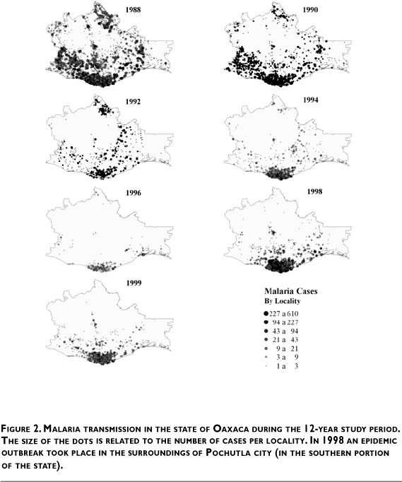
Malaria Transmission Intensity Index in the state of Oaxaca. A total of 6 183 localities were included in the study, after eliminating the localities with altitude higher than 1 500 m above sea level. Among those localities included, 4 401 (71.18%) had null transmission, 349 (5.64%) were in the low MTII category, 958 (15.49%) were in the mid MTII category, and 475 (7.568%) were in the high MTII category. The geographic distribution is depicted in Figure 3.

Association of ecological factors and malaria transmission intensity in the state of Oaxaca
A high malaria transmission intensity index was strongly associated with three environmental variables: elevation, climate and evaporation. The distribution of the MTII according to these variables is shown in Table II.

The proportion of localities with high MTII was 6.6 times higher in elevations between 200 and 500 m above sea level (p< 0.0001, 95% CI: 3.86-11.54), and 3.3 times higher in elevations below 200 m (p< 0.0001 95% CI: 1.85-5.88) compared to localities over 1 200 m above sea level.
Localities located in tropical weather with summer rainfall (Aw) climate areas were also associated with high MTII. In the analysis of the whole state of Oaxaca, there were three sub climate groups corresponding to Aw climate: Aw1, Aw2 and Awo presented 1.8 (95%CI: 1.2-2.69), 3.7 (95% CI: 2.48-5.57) and 2.7 (95% CI: 1.87-4.03) times higher proportions of localities with high MTII, respectively (p< 0.0001 in the tree subtypes), compared to the rest of the climate types in the state. Low water evaporation was strongly associated with high MTII. The proportion of localities with high MTII in areas with evaporation lower than 800 mm per year was 9.1 times higher than those where evaporation was higher than 1 000 mm per year (p< 0.0001, 95% CI 6.06-13.59). Similarly, the proportion of high MTII localities in areas where evaporation was between 800 mm and 1 000 mm was 4.8 times higher than those with evaporation higher than 1 000 mm (p< 0.0001, 95% CI: 3.29-7.00). After adjusting for these three variables (climate, evaporation and elevation), all others were not statistically significant.
Characterization of malaria transmission patterns in the state of Oaxaca. The empirical Bayesian spatio-temporal filter used to analyze incidence in the grid cells in which the state was divided indicated that the focus of persistent transmission was situated around the city of Pochutla (Figure 4). In this area, the adjusted malaria incidence rate in most of the cells (86 out of 146) fluctuated between 22.28 and 186.28 cases per 1 000 inhabitants. With this information, a study area was set between 97° 40' 21" W, 15° 36' 12"N and 95° 10' 05"W, 16°51'10"N, encompassing 31 440 km2 (more than 1 200 cells) and including a total of 2 199 villages, of which 1 082 had registered at least one malaria case during the study period. The main cities in the area are Salina Cruz, Santo Domingo de Tehuantepec, San Blas Atenpa, Miahuatlan, Puerto Escondido, San Pablo Huixtepec, and Pochutla.

There are three general hospitals with 30 or more beds in the study area; these are located in Salina Cruz, San Pablo Huixtepec and Pochutla. The catchment areas of a hospital located in the city of Pinotepa Nacional extends into the study area and, for this reason, it was also considered in our analyses. Elevation of localities within the study area ranged from sea level to 2 900 m above sea level, but as stated in the methodology section, localities higher than 1 500 m above sea level were discarded from the statistical analyses. The MTII distribution by altitude is shown in Table III. Population ranged between 6 and 36 888 inhabitants (Figure 4). The MTII distribution by locality size is shown in Table III. The main climate types, according to the Köpen classification, found in the study area (INEGI 1990) were: tropical weather with summer rains (Aw), where 478 990 people inhabited; semi-warm ([A]C) with 104 256 inhabitants; semi-arid (Bs) with 455 332 inhabitants, and temperate (C) with 15 121 inhabitants (Figure 5). The distribution of the MTII by climate is also shown in Table III.


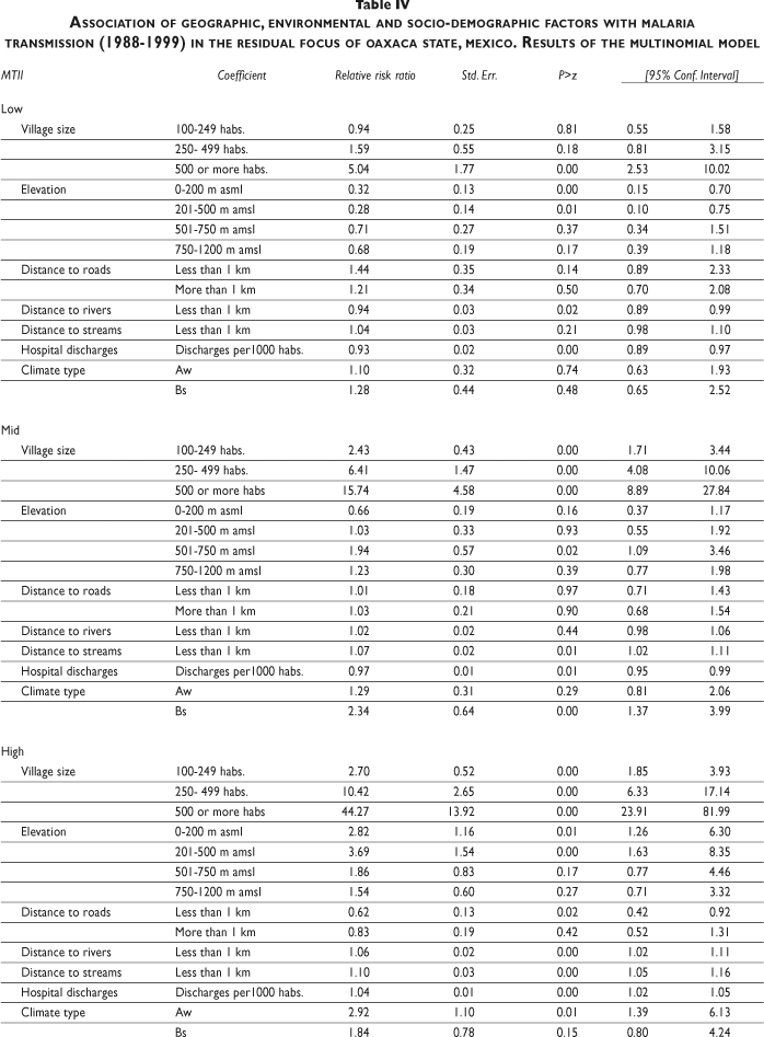
Association of geographic, environmental and social factors with malaria transmission in the residual focus. After discarding localities above 1 500 m altitude, the distribution of villages in the study area, according to their MTII, was: 325 high, 341 medium, 142 low and 717 with no transmission. Most of the villages with the highest index (223 of 337) were located in the area around Pochutla City (with a range of approximately 60 km to the east and west of Pochutla and from the coast up to 30 km to the north, Figure 5). No significant effect of the poverty index was detected in any of the models, probably because there was very little variation in the study area (more than 94% of the villages were classified as high or very high poverty level).
In the exploratory analyses, rainfall and temperature were highly correlated with each other and also with the climate type; thus, only the climate type variable was included in the model to avoid the adverse effects caused by co-linearity among independent variables. Although climate and elevation are somehow correlated, both were kept in the final model because of the highly significant association these variables had on the distribution of the MTII.
The results of the ordered logistic model indicate that the size of the locality had a positive association with the MTII (p= 0.005), and the rate of Pochutla's general hospital discharges in the municipalities where the villages are located also had a positive association with the MTII (p< 0.001). Aw and Bs climate types were positively associated with the MTII (p= 0.003, p= 0.011, respectively). Localities in the 201 m -500 m elevation range were associated with the greatest risk of transmission (p= 0.009), followed by localities that were at less than 200 m above sea level (p= 0.046). The type of land use and vegetation coverage had no significant effect on the MTII after adjusting for elevation and climate. Temporary streams in the vicinity of localities (within the buffer) had a highly significant positive association with the MTII (p < 0.001), perennial rivers also had a positive association with it but this was marginally significant (p= 0.096). Nevertheless, it was kept as an explanatory variable in the model because it is also associated with mosquito breeding sites.
The results of the multinomial model (Table IV) clearly show the association between the size of the locality and the malaria transmission intensity index. There is an increasing trend in the coefficients associated with increasing size of the locality in all the strata. This is more evident in the high MTII strata in which all of the coefficients are statistically significant: the odds of high MTII is 44.3 times higher in localities of 500 inhabitants or more (p< 0.0001, 95%CI: 23.91-81.99), compared to localities of less than 100 inhabitants. Similarly, the odds of medium MTII is 15.7 higher in localities of 500 inhabitants or more (p< 0.0001, 95% CI: 8.90-27.84), compared to localities of less than 100. Regarding altitude, the odds of high MTII are 3.7 times higher in elevations between 200 and 500 m above sea level compared to elevations above 1 200 m (p< 0.0001, 95% CI: 1.63-8.35). The odds of mid MTII is 1.94 times higher in elevations between 500-750 m above sea level, compared to elevations above 1 200 m (p< 0.024, 95% CI: 1.09-3.46).
Distance to roads is only significant in the high malaria transmission intensity index stratum; the odds of high MTII is 1.6 times lower in localities that are less than one km away from the nearest road compared to localities further away (p< 0.018, 95% CI: 1.07-2.40).
The odds of all of the MTII strata increase with the number of rivers and streams. This is more evident in the high MTII stratum, where the number of both rivers and streams are statistically significant (p= 0.004, p< 0.0001, respectively). In the mid MTII stratum only streams are statistically significant (p= 0.005), and in the low MTII stratum the statistically significant association is with rivers (p= 0.002).
Climate type is also associated with the MTII: the odds of high MTII in climate Aw is 2.91 times higher than in types C and (A)C (p< 0.005, 95% CI: 1.39-6.13) and the odds of mid MTII in climate type BS is 2.34 (p< 0.002, 95% CI: 1.37-3.99) times higher than in C and (A)C. Finally, the odds of high MTII increases 1.03 times with each unit increment in the Pochutla's discharge rate (persons per thousand inhabitants discharged). The catchment areas of the rest of the hospitals in the area had no significant association with the MTII.
DISCUSSION
The results of this study corroborate the aggregation of malaria endemic villages in a well-delimited area (residual focus) on the Pacific Ocean coast of the state of Oaxaca. They also indicate that climatic, geographic and environmental conditions, most probably determining the breeding and abundance of mosquito vectors, are associated with differences in malaria transmission among the localities in the residual focus. These conditions seem to determine the receptivity for malaria infection in the geographic area; human activities are responsible for the introduction and dispersion of the malaria infection among and within villages in the focus, and socio-demographic and ecologic factors influence the intensity of human exposure to mosquitoes. The existence and effect of such contact depend on and is modulated by local and regional biological, ecological and social factors. Overall, in the presence of parasites in the area, enough contact between humans and mosquito vector populations occur to maintain malaria transmission.16
The geographic extension of the state encompasses diverse climatic and ecological areas in which other variables interact in diverse ways to produce a mosaic of ecological situations, but the analysis of the geographical distribution of the annual malaria incidence during the 12 years of study, followed by a Bayesian analysis, circumscribed the persistent transmission focus in the area around the city of Pochutla. Epidemiologically, malaria transmission among the localities of the residual focus varied in incidence and in the length of time when new malaria cases occurred, as well as in the number of outbreaks during the study period. This is a reflection of the receptivity in each locality to the initiation of local transmission (presence of vector mosquitoes and susceptible human individuals) and the capacity for maintaining transmission (time of persistence of mosquito vectors). Thus, an intensity index (MTII) was constructed in order to create a parameter representing all variables defining the diverse types of transmission. This was used in the analysis of possible factors that could affect malaria transmission.
The survival of mosquitoes and the development of malaria parasites in their vector closely depend on environmental factors.17 The main environmental conditions that define the ecology of the residual focus were the climate, defined as tropical with summer rains, low evaporation index and altitude. Our group has documented that, as in most of the Mexican territory,2,18 two anopheline species are the main malaria vectors in the hyper-endemic focus of Oaxaca: An. albimanus in the coasts and An. pseudopunctipennis in the foothills (unpublished data). The environmental conditions in most parts of the residual focus are optimal for the breeding and survival of the main malaria vector in the area, An. pseudopunctipennis.
The results of the generalized mixed logistic model confirm a positive association between the MTII and climate, low evaporation and medium high altitudes. Previous studies had demonstrated a close association of mosquito breeding with the use of the land surrounding villages.19,20 This is particularly true for mosquitoes that breed in water collections caused by modifications introduced into the environment by human activities, such as An. albimanus that breed in rain ponds in unmanaged pastures. The evaluation of the coefficients in the table indicates that villages with a high MTII were more prevalent in the foothills of tropical areas with summer rains. But land use had no effect on the MTII, most probably because vector mosquitoes in the study area breed in river ponds that are unrelated with the immediate surroundings. In this area, the topology and summer rains produce extravasations of the rivers that during the dry season result in river ponds. The persistence of these ponds is favored by low evaporation, and they are eventually colonized by filamentous algae, making them excellent An. pseudopunctipennis larvae breeding sites.21,22 This was confirmed by the analysis of local conditions around the localities. The model showed a positive association: high MTII villages are situated along the total length of rivers and temporary streams, medium MTII contain temporary streams and low MTII villages have rivers crossing in the vicinity of the villages (the buffer around each locality). The high flow of rivers is less favorable to the formation of river ponds, but topology that facilitates temporary streams when abundant rainwater is present can produce extensive areas of river ponds –the favorite breeding site of An. pseudopunctipennis. In addition, the total number of malaria cases in the focus during the 1998 outbreak was also most abundant in villages located in the foothills (data not shown), indicating the precarious equilibrium of the malariogenic system that, under extreme ecological disturbance, could produce abundant mosquito vectors and thereby initiate an outbreak. Since then, the removal of algae that favor the breeding of An. pseudopunctipennis in the surrounding rivers has been very effective for diminishing the abundance of this mosquito and for controlling malaria in the focus.3
The intensity of malaria transmission was associated with the size of the localities. This association indicates the need for both a minimum susceptible population to maintain transmission23 and the effect of human activities that introduce and disperse the parasite within the residual focus. This effect could explain the location of high, but not low and medium, MTII villages near roads. Proximity to roads favors human movements that may facilitate the repeated introduction of the malaria parasite, while more isolated localities would have fewer outbreaks because of their small size and fewer human movements outside the villages.
Parasite dispersion by human movements within the residual focus is one of the most interesting characteristics of malaria transmission in the area. The analysis of patients' discharges from the main hospitals in the area confirmed that the localities with the highest MTII were grouped around the area of economic development of Pochutla. These observations suggest that short-range population movements are a determinant for the dissemination and maintenance of the transmission within the focus.
Presently, malaria transmission is under control in the focus. Control strategies such as larval breeding site manipulation maintain mosquito populations at low levels during the transmission season, and a new drug treatment strategy aimed at eliminating relapses has depleted local circulating parasites.3 However, the possibility of a reintroduction of malaria parasites by infected labor migrants is always existent (the area is part of the migratory corridor that extends from Central America to northern Mexico). The tight ecological, demographic and socioeconomic conditions that made this residual focus resilient to control and the main producer of malaria cases in the past indicates the need for maintaining vector control activities long beyond the elimination of local transmission, and strengthening epidemiological surveillance activities for the early detection of incident and introduced malaria cases. The distribution of MTII could provide guidance to this effect.
Acknowledgments
This study was supported by a grant from the International Development Research Centre, Canada (IDRC No. 100194) and a grant from the National Council for Research and Technology, Mexico (CONACyT no. 31466-M).
REFERENCES
1. Pan American Health Organization 2005. Area of health Analysis and Information Systems (AIS). Health Situation in the Americas: Basic Indicators 2005. Washington, DC: PAHO, 2005. [ Links ]
2. Tellaeche AM. La evolución y situación actual del paludismo en México. In: Kumate J, Martínez-Palomo A, eds. A Cien Años del Descubrimiento de Ross. El Paludismo en Mexico. Mexico, DF: El Colegio Nacional, 1998; 209-218. [ Links ]
3. Chanon KE, Méndez-Galván JF, Galindo-Jaramillo JM, Olguín-Bernal H, Borja-Aburto VH. Cooperative actions to achieve malaria control without the use of DDT. Int J Hyg Environ Health 2003; 206: 387-394. [ Links ]
4. Molineaux L, Muir DA, Spencer HC, Wernsdorfer WH. The epidemiology of malaria and its measurement. In: Wernsdorfer WH, McGregor I, eds. Malaria, principles and practice of Malariology. Edinburgh: Churchill-Livingstone 1988;2: 999-1089. [ Links ]
5. Mendis K, Sina BS, Morchesine P, Carter R. The neglected burden of Plasmodium vivax malaria. Am J Trop Med Hyg 2001; 64: 97-106. [ Links ]
6. Geenwood B. The microepidemiology of malaria and its importance to malaria control. Trans R Soc Trop Med Hyg 1989;83:S25-S29. [ Links ]
7. Focks DA, Brenner RJ, Chadee DD, Trosper JH. The use of spatial analysis in the control and risk assessment of vector-borne diseases. Am Entomol 1999;45:173-183. [ Links ]
8. Pope KO, Rejmankova E, Savage HM, Arredondo-Jimenez JI, Rodriguez MH, Roberts DR. Remote sensing of tropical wetlands for malaria control in Chiapas, Mexico. Ecol Appl 1994;4:81-90. [ Links ]
9. Beck LR, Rodriguez MH, Dister SW, Rodriguez AD, Rejmankova E, Ulloa A et al. Remote sensing as a landscape epidemiologic tool to identify villages at high risk for malaria transmission. Am J Trop Med Hyg 1994;51:271-280. [ Links ]
10. Kitron U. Landscape ecology and epidemiology of vector-borne diseases: Tools for spatial analysis. J Med Entomol 1998;35:435-445. [ Links ]
11. Snow RW, Peshu N, Forster D, Bomu G, Mitsanze E, Ngumbao E, et al. Environmental and entomologic risk factors for the development of clinical malaria among children on the Kenyan coast. Trans R Soc Trop Med Hyg 1998;92:381-385. [ Links ]
12. Ghebreyesus TA, Haile M, WittenKH, Getachew A, Yohannes M, Lindsay S, et al. Household risk factors for malaria among children in the Ethiopean highlands. Trans R Soc Trop Med Hyg 2000;94:17-21. [ Links ]
13. Snow RW, Gouws E, Omumbo JA, Rapsoda BA, Graig MH, Tanser FC, et al. Models to predict the intensity of Plasmodium falciparum transmission: applications to the burden of disease in Kenya. Trans R Soc Trop Med Hyg 1998;92:601-606. [ Links ]
14. Kleinschmidt I, Omumbo JA, Briët O, van de Giesen N, Sogoba N, Mensah N, et al. An empirical malaria distribution map for West Africa. Trop Med Int Health 2001;6:779-786. [ Links ]
15. Craig MH, Snow RW, le Sueur D. A climate-based distribution model of malaria transmission in sub-Saharan Africa. Parasitol Today 1999;15:105-111. [ Links ]
16. Rogers DJ, Randolf SE, Snow RW, Hay SI. Satellite imagery in the study and forecast of malaria. Nature 2002;415:710-715. [ Links ]
17. Hay SI, Guerra CA, Tatem AJ, Noor AM, Snow RW. The global distribution and population at risk of malaria: past, present and future. Lancet Infect Dis 2004;4:327-336. [ Links ]
18. Star J, Estes J. Geographic Information Systems. An Introduction. Englewood Cliffs, New Jersey: Prentice-Hall, 1990. [ Links ]
19. Hosmer DW, Lemeshow S. Applied Logistic Regression. New York: John Wiley and Sons, 1989. [ Links ]
20. McCullag P, Nelder JA. Generalized to line models 2nd edition. New York: Chapman and Hall, 1989. [ Links ]
21. Brown H, Prescott R. Applied Mixed Models in Medicine, New York: John Wiley and Sons, 1999. [ Links ]
22. Kleinschmidt I, Sharp BL, Clarke GPY, Curtis B, Fraser C. Use of Generalized linear mixed models in the spatial analysis of small-area malaria incidence rates in KwaZulu Natal, South Africa. Am J Epidemiol 2001; 153:1213-1221 [ Links ]
23. Moran PAP. The interpretation of statistical maps. J R Stat Soc 1948; Series B 10: 243-251. [ Links ]
24. Moran PAP. Notes on continuous stochastic phenomena. Biometrika 1950; 37: 17-23. [ Links ]
25. Cressie N, Hawkins DM. Robust estimation of the variogram. Math Geol 1980; 12: 115-125. [ Links ]
26. Bailey CT, Gatrel CA. Interactive Spatial Analysis. Essex, England: Longman, 1995. [ Links ]
27. Kennedy-Kalafatis S. Reliability-adjusted disease maps. Soc Sci Med 1995;41:1273-1287. [ Links ]
28. Bruce-Chwatt LJ. Essential Malariology. New York: John Willey and Sons, 1985. [ Links ]
29. Savage HM, Rejmankova E, Arredondo-Jimenez JI, Roberts DR, Rodriguez MH. Limnological and Botanical characterization of larval habitats for two primary malarial vectors, Anopheles albimanus and An. pseudopunctipennis, in coastal areas of Chiapas State, Mexico. J A Mosq Control Assoc 1990; 6: 612-620. [ Links ]
30. Villareal-Treviño C, Arredondo-Jimenez JI, Rodriguez MH. Bionomía de los principales vectores del paludismo en México. En: A Cien Años del Descubrimiento de Ross. El Paludismo en México. Kumate J, Martínez-Palomo A. eds. Mexico DF: El Colegio Nacional, 1998;149-165. [ Links ]
31. Rodriguez AD, Rodriguez MH, Hernandez JE, Dister SW, Beck LR, Rejmankova E, et al. Landscape surrounding human settlements and Anopheles albimanus Wiedemann (Diptera: Culicidae) abundance in southern Chiapas, Mexico. J Med Entomol 1996; 33: 39-48. [ Links ]
32. Beck LR, Rodriguez MH, Dister SW, Rodriguez AD, Washino RK, Roberts DR, et al. An assessment of a remote sensing-based model for predicting malaria transmission risk in villages of Chiapas, Mexico. Am J Trop Med Hyg 1997; 56: 99-106. [ Links ]
33. Fernández-Salas I, Roberts DR, Rodríguez MH, Marina-Fernández-CF. Bionomics of larval populations of Anopheles pseudopunctipennis in the Tapachula foothills area, southern Mexico. J A Mosq Control Assoc 1994;10:477-486. [ Links ]
34. Manguin S, Roberts DR, Peyton EL, Fernandez-Salas I, Barreto M, Fernandez-Loayza R, et al. Biochemical systematics and population genetic structure of Anopheles pseudopunctipennis, vector of malaria in Central and South America. Am J Trop Med Hyg 1995; 53: 362-377. [ Links ]
35. Anderson RM, May RM. Infectious Diseases of Humans: Dynamics and Control. 2nd edition. Oxford: Oxford University Press, 1991. [ Links ]
Received on: January 5, 2006
Accepted on: April 24, 2006
Address reprint requests to: Mario H. Rodríguez. Instituto Nacional de Salud Pública. Av. Universidad 655, Col. Santa María Ahuacatitlán. 62070 Cuernavaca Morelos, México. E-mail: mhenry@insp.mx

