


 nueva página del texto (beta)
 Inglés (pdf)
 Artículo en XML
 Referencias del artículo
 Enviar artículo por email
 Citado por SciELO
  Similares en
SciELO
Similares en
SciELO 
 Permalink
Introduction
Brazil is a country of continental dimensions, dominated by tropical climate and highly variable rainfall regimes. The collection and distribution of water in Brazil is primarily based on surface sources, such as rivers and lakes. Issues related to the expansion of urban centers in different regions of the country, seasonal events of prolonged drought and the predominance of precarious water infrastructure represent the main causes of shortages or intermittent supply of water to urban centers.
Based on data from 2018, the country has on average 84% of households with access to water and only 53% served by sanitary sewage systems, with a 45% for the case of the southern region of Brazil (SNIS, 2018). Sewage collection and direct river discharge is the predominant form of sanitary sewage in small and medium-sized cities in Brazil, with direct environmental impacts on flora and fauna, as well as restricting its use in response to public supply demands (SNIS, 2018).
The universalization of the public water supply system in Brazil is a reality based on massive public investment and public-private partnerships. However, a question of great relevance is the average loss of 38% of water throughout the distribution system, due to its length and complexity, lack of maintenance, degradation of the system, clandestine connections, among other aspects (SNIS, 2018). In European countries, this average is 15 to 25% and in Japan reaches 8% at most (DIEESE, 2016).
An alternative to the extensive and inefficient public supply networks is the use of independent water collection systems. In regions lacking surface water sources or peripheral to the usual public supply systems, groundwater sources may be a highly practicable technical and economical alternative (Balek, 1989).
Although surface water pollution, the interactions between surface and groundwater in the hyporheic zone, have a great capacity to attenuate this pollution due to the specific geochemical environment found in these regions, which can translate quality in groundwater even in these areas of recharge of influent streams (Hester et al., 2013). The extraction of groundwater is an alternative that has been increasingly exploited by industries, agriculture and communities far from public water supply networks (Hiscock, 2005; Elgzeli et al., 2013).
Fractured aquifer systems are considered particularly complex, due to the condition of storage and transmission of water throughout the fractured planes. Although recharge occurs mainly from rainwater or from free surficial aquifers. In many cases, the existence of groundwater in fractured zones is not always evident from the surface (McCuen, 1998; Singhal and Gupta, 2010).
The intrinsic structural complexity of fractured aquifer systems frequently results in the predominance of dry wells or with insufficient flows to meet the human demands. In this sense, the identification of favorable sites to groundwater accumulation is the geomorphological interpretation of aerial photographs and satellite images, combined with geological field works and geophysical surveys (Brassington, 2007).
Geophysical methods represent a powerful tool in the study of fractured rock aquifers, in view of their sensitivity to measure physical parameters that change in the presence of water within fractures, wide spatial coverage and versatility in the depths of investigation, as well as a limited time for data acquisition and processing (Telford et al. 2004). An essential aspect in the geophysical studies of fractured aquifers is the reduction of uncertainties and the possibility of defining promising targets for water exploitation, and the reduction of costs in drilling (Knödel et al., 2007).
The use of Electrical Resistivity Tomography (ERT) allows two-dimensional underground investigations, which may reveal potential fractured rock aquifers. A particularly challenging paradigm is the adaptation of a geophysical survey method with mathematical formulation based on isotropic and homogeneous media for use in highly anisotropic and heterogeneous media (Rubin and Hubbard, 2005). Even so, studies involving ERT surveys in a crystalline geological environment showed that the method is efficient in this kind of hydrogeological investigation (Okpoli, 2013; Sequeira Gómez & Escolero Fuentes, 2010; Moreira et al., 2016; Moreira et al., 2019).
This work presents and discusses the results obtained by using geological and structural analysis, coupled with ERT surveys for the identification of favorable areas for groundwater extraction in a small village located in southern Brazil, which possess restricted surface water resources. The acquisition of geoelectrical data and the generation of pseudo 3D models from 2D inversion employed in this study, aims to recognize structural alignments at various depths, which represent potential targets for groundwater exploitation.
Material and Methods
Geology of the Study Area
The study area is in a rural property six kilometers north from center of Caçapava do Sul, a municipality located in southern Brazil (Figure 1). This region of the State of Rio Grande do Sul (RS) comprises small size municipalities with population varying between 10,000 and 60,000 inhabitants. Economic activity is based on soybean farming, extensive livestock farming and services.

Basic sanitation services are managed by Corsan (Companhia Riograndense de Saneamento S/A), a state-owned company created in 1965 currently serving 2/3 of the state population or 6 million people in 316 municipalities. The urban area of the municipalities under its administration is almost universally served by intermittent supply of drinking water, although it presents under 30% of collection and sanitary sewage. The rural area is predominantly served by surface or groundwater, independent of the public network, which serves only the urban centers.
Geologically, the study area is part of the syntectonic Caçapava do Sul granitic suite, contained in the Ocidental Domain of the Sul-Rio-Grandense Shield (CPRM, 2000). The syntectonic granitoids intruded the metamorphic units of the Ocidental Domain and show mylonitic foliation with NNE orientation.
The Caçapava do Sul granitic suite comprises a dome-like shaped body with 25 km2 oriented in the N-S direction, dated 549 Ma, and surrounded by low-grade metamorphic rocks. The contacts of the Caçapava do Sul granitic suite with the metasedimentary rocks of the Vacacaí Metamorphic Complex are generally concordant with the main foliation of the metamorphites (Nardy and Bitencourt, 1989).
This suite is dominantly constituted by monzo and syenogranitic rocks. Granodioritic and tonalitic rocks are less common and occur in the western border of the main intrusive body. Due to the diverse petrographic types of granitoid rocks, the Caçapava do Sul suite has been described by three main lithofacies: biotite granites, leucogranites and transitional granites (CPRM, 2000).
Structural analyzes performed by Bittencourt (1983) in the northern and southeastern regions of the Caçapava granitic suite allowed the recognition of three deformation events. The first event is related to the development of pre-kinematic porfyroblasts with respect to the regional foliation of the host rocks. The second event is associated to the development of the regional foliation, which also affected the granitoid rocks, and the last deformation event was responsible for the generation of an antiform structure where the Caçapava do Sul granitic suite is lodged. The last two deformation events significantly affected the Caçapava do Sul intrusive suite. Regionally, these events are defined as D3 and D4 deformation phases and are both related to compressive stress during magma cooling, in 549 Ma (Nardi and Bitencourt, 1989).
In the east center of the study area there is a pond which was excavated up to the contact with the granitic rock, with 2m of deep. It is believed that the fractured aquifer system and the pond may be recharged by the free aquifer, since during the dry season it remains with water. Generally, the flows produced by wells are small, and the water, due to the lack of circulation and the type of rock, is, in most cases, salinized (PMSB, 2013). Wells usually have specific capacities below 0.5 m3/h/m, with dry wells also occurring (Machado & Freitas, 2005).
Structural and Geophysical survey
Fractures are often detected in aerial photographs because they are recognized by linear changes in topography, drainage, or vegetation patterns, as well as different colors of rocks and soils (Miller and Miller, 1961; Sabins, 1985; 1996). In addition, fractured rocks show signs of weathering and erosion (Knödel et al. , 2007).
In the field, the first stage of data acquisition consisted of a preliminary geological reconnaissance, consisting of the identification of rock exposures. This analysis structural work carried out in granite outcrops found in the vicinity of the study area was of paramount importance for defining the main fracture families. At the study site, granite is found with varying degrees of alteration and fracturing, often being covered by fractured sandy lithosol.
The amount and orientation of the electrical tomography profiles was driven by the regional structural data, field structural data and by the availability of accesses to the study area. The acquisition of geophysical data consisted of electrical resistivity readings using the electrical resistivity tomography (ERT) technique in a Wenner-Schlumberger arrangement. This configuration tends to have more sensibility and favor the representation of lateral variations, being more suitable for the identification of conductive (low resistivity) vertical structures or zones (Moreira et al., 2016).
In a crystalline geological environment, as in the case of the study area, the expected hydrogeological profile is one of shallow soil responsible for recharging possible fracture zones. To detail this more superficial zones, 10 m of spacing among electrodes were used in four parallel survey lines oriented in the N282 direction with individual length of 400 m and (Figure 1).
The geophysical equipment used was the Terrameter LS, manufactured by ABEM Instrument (Sweden), which consists of a single automated signal transmission and reception module (based on previous programming), with 250W of power, 1μV resolution and maximum electric current of 2.5A (ABEM, 2012).
The measurements acquired in the field were processed in the Res2Dinv computational program. The results comprise resistivity profiles of distance versus depth presented in logarithmic scale in which the values are inverted, interpolated, and displayed in intervals of colors. This program automatically determines a two-dimensional subsurface model from resistivity obtained in ERT surveys (Griffiths and Barker, 1993).
The 2D model used in the program divides the pseudo-section into rectangular blocks, which will represent the pseudo-section by adjusting the field measurements. This optimization aims to reduce the difference between the apparent resistivity values, calculated and measured in the field, by adjusting the resistivity of the block model, whose difference is expressed by the root mean squared error (RMS), and its product is represented as inversion models (Loke and Barker, 1996).
The two-dimensional inversion numerical data of each section was gathered in a single spreadsheet, which joins the position of the readings along the surveying lines (variable "x"), spacing of the surveying lines (variable "y"), depth modeled by inversion (variable "z") and the electrical resistivity value (variable "R"). This spreadsheet was used in order to generate 3D visualization models, in a routine of basic steps embraced in mineral exploration. In this case, the sampling plan is often defined from statistical, structural and geometrical criteria of mineral accumulations (Moon, 2006).
Geophysical 3D visualization models derived from 2D sections, also known as quasi-3D or pseudo-3D models, provide a very broad understanding of the complexity of geological structures and mineral deposits; but also, present significant results in applied geophysics in contaminated areas, tailing dams and hydrogeology (Moreira et al., 2015; Côrtes et al., 2016; Camarero et al., 2019; Helene et al. , 2021).
Results and Discussion
Initially, the results are based on regional geomorphological lineaments interpreted from satellite images that reveals a similar pattern in both the granitoid rocks and the surrounding metamorphic complex (Figure 2B). The fracture orientations were extracted from satellite imagery and integrated with measurements on rock exposures and assembled in a diagram (Figure 2C), which indicates predominant orientation for N315°, with fracture groups in the N350° and N50° directions with less frequency.

Figure 2 Geological and structural aspects of the study area. 2A) Main regional geological units. 2B) Regional lineaments extracted from satellite images. 2C) Diagram of structural measurements obtained from satellite images and field measurements.
Geophysical fieldwork was driven by previous geological survey in order to identifying rock exposures and geological fractures (Figure 3A and 3B). In a road close to the study area occur outcrops of jointed and fresh porphyritic leucogranites (Figure 3C).

Figure 3 Geological features identified in structural survey: 3A) fractures in sandy saprolite. 3B) fractures in fresh granite. 3C) fractures in granite massif.
The resistivity models generated from the ERT data are presented in logarithmic scale to allow a comparative analysis among the sections and the range of resistivity values varied from 11 Ωm to 51.851 Ωm RMS below 8%, indicative of low deviation and satisfactory models (Figure 4).
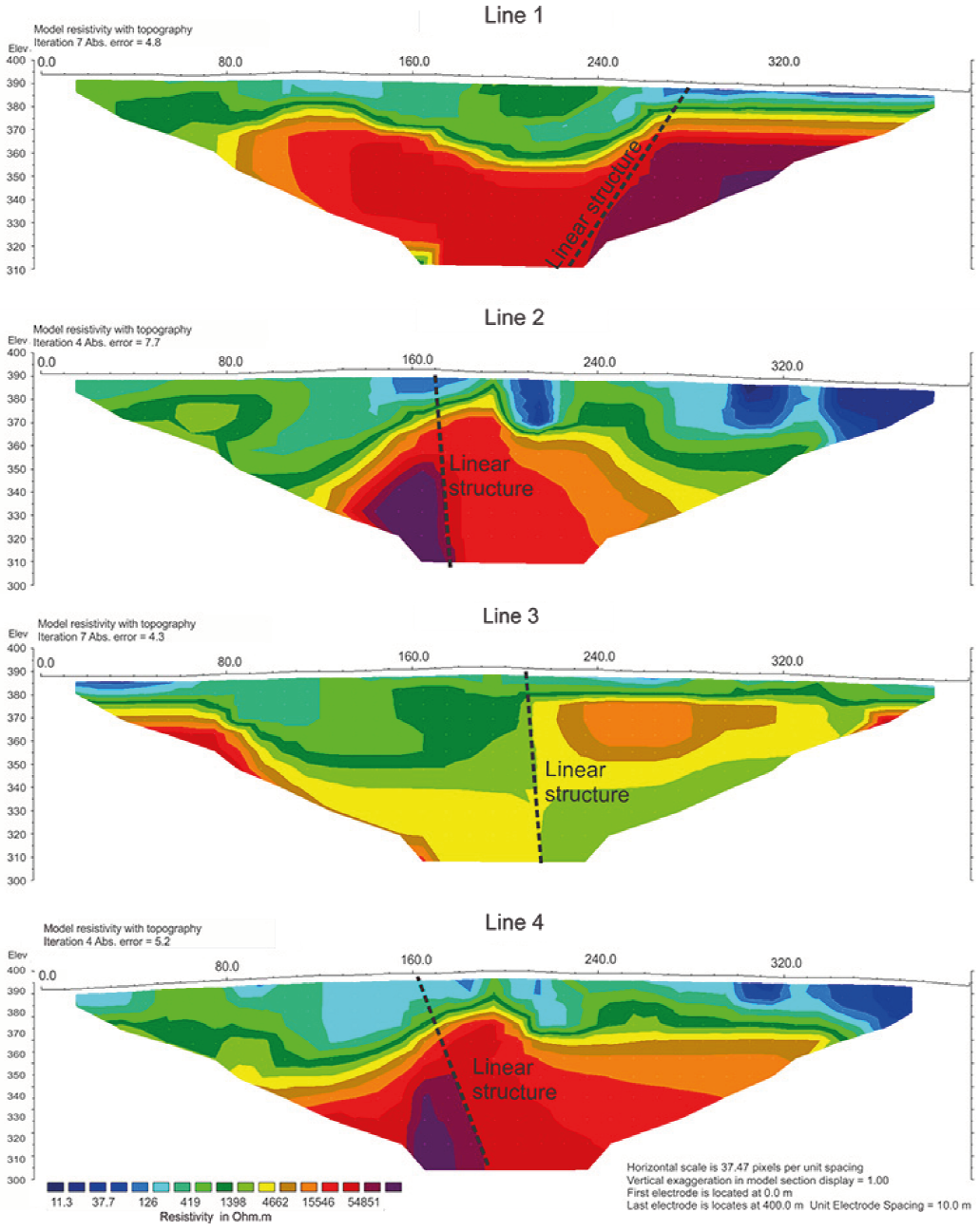
Figure 4 Electrical resistivity inversion models with interpretation of linear features (fractures) related to geological structures.
The inversion models are characterized by a superficial layer with resistivity values lower than 100 Ωm with a significant variation of thickness, but limited between the interval of 0m and 40m, which possibly reflects the regolith profile. This wide variation in the thickness of this superficial layer reflects a selective action of weathering processes and alteration of granite rock.
The deeper portions of the profile are related to the ease of rainwater infiltration in fractured zones and consequent hydration of minerals such as feldspars and micas. The shallower portions, which are more resistant to chemical weathering, are constituted by unjointed or moderately jointed rock masses, with predominance of quartz in the rock matrix. Portions of the rock mass with resistivity values lower than 40 Ωm may indicate higher permeability, with accumulation of groundwater and/or rocks enriched in weathered minerals like biotite and feldspars, that locally result in concentrations of clay minerals in fractures. Resistivity values greater than 1.000 Ωm indicate the presence of loose rocky masses and moderately weathered.
The Line 3 presents values between 1.000 Ωm and 5.000 Ωm, the smallest range of variation among the set of sections studied. The other sections exhibit values of resistivity predominantly between 1.000 Ωm and 20.000 Ωm, and some portions with extreme values, greater than 50.000 Ωm. This huge variation in resistivity values may be related to variations in the moisture content of the rock-mass. The resistivity values higher than 20.000 Ωm displayed in the profiles were intended to enhance linear features related to fractures and faults (Figure 4).
The orientation and slope of the fractures interpreted in the profiles of Figure 4 are consistent with the structural pattern described during the preliminary geological reconnaissance phase (Figure 2 and 3). Although contained largely within highly resistive zones, except for Line 3, this set of geological fractures possibly presents a connection with the weathering mantle and, consequently, with the free aquifer.
The ERT lines were planned with the objective of identifying linear structures with lateral continuity. However, an analysis of the positions of the fractures projected in the sections reveals independent fractures and limited lateral continuity, which, at first, indicates low favorability for groundwater exploitation, once the connectivity and lateral continuity of the structures is a key factor for ground-water accumulation.
In order to evaluate the lateral continuity and possible connectivity of the fractures recognized in the 2D sections, 3D visualization models were elaborated, and resistivity maps were generated for different depths (Figure 5).

Figure 5 Pseudo 3D model and maps of electrical resistivity sliced for different elevations (in meters above sea level), with interpretation of linear structures (potential fractures).
The map referring to the elevation of 395m is characterized by wide diffuse areas with electrical resistivity below 100 Ωm, evidence of accumulation of water in the superficial porous aquifer. The maps of the elevation of 385m to 365m show a reduction of areas of low resistivity and an increase of areas where saprolite rock and granite rock with distinct degrees of chemical weathering may predominate. These maps do not show evidence of linear features like fractures or faults, possibly due to the chemical weathering of the rockmass, which attenuates the contrasts of the geophysical properties, resulting in a homogeneous medium.
From the elevation of 355m, there are indications of a possible linear features that form a triple junction pattern of lineaments oriented in the N104, N205 and N325 directions. This feature is most evident in the maps of the elevation of 345m and 305m (Figure 5).
The integrated analysis of the 2D inversion models and the 3D visualization models (pseudo 3D) allow some considerations. The resistivity pattern found in Line 3 where values below 4.500 Ωm predominates is essentially related to the orientation of this line along a possible saturated geological fracture. This resulted in a relatively homogeneous pattern, distinct from the average values for the granite rock horizon of the other sections that is above 15.000 Ωm and below the elevation of 355m.
The existence of individual fractures in a rockmass with low resistivity does not make it promising for the exploitation of groundwater. Fracture connectivity is a key condition for the storage and transmission of groundwater in fractured rock aquifers. Even in the absence of local superficial evidence, a fracture system, relevant to the groundwater flow, can be manifested on a regional scale, conditioning the relief and the drainage network. Such aspects are usually considered in studies of fractured aquifers (Lee and Farmer 1993; Skinner and Graham 2004; Zouhri and Lutz 2016; Moreira et al., 2017).
Figure 6 compares the drainage network pattern in the region of study, with anomalous zones of resistivities in the study area for 60m depth in this study. As it can be seen by the satellite image, there is a high correlation of these drainage patterns at different scales. The area of intersection among the structural alignments represents the most favorable locations for groundwater exploration.

Conclusions
Geological fractures are essential features for the storage and movement of groundwater throughout rocky masses. The expression of these landforms on the topographic surface is not always evident. The joint analysis of geomorphological and structural aspects both locally and regionally, are essential for the programming of geophysical surveys geared to hydrogeological studies.
The technique of electrical resistivity tomography is particularly relevant in the identification of geological discontinuities that can serve as pathways for the accumulation and movement of groundwater. However, this work revealed a particular case, in which the geological structures identified in the 2D inversion models, similar to those described in rocky exposures, would be, in principle, poorly favorable for hydrogeological purposes due to the apparent lack of connectivity of structures.
The connectivity of the fracture system was clearly highlighted in the pseudo 3D models. Below 40m depth, low resistivity values (about 500 Ωm), aligned in three different well-defined directions, were detected adjacent to high resistivity values (> 15.000 Ωm), which indicate the presence of saturated fractures. Similar structural features are recognized in the drainage network around the study area to which water springs are associated. The low number of producing wells for groundwater exploitation in fractured rock aquifers can be substantially increased by integrating traditional geological analysis at different scales and geophysical research tools.

