


 nueva página del texto (beta)
 Inglés (pdf)
 Artículo en XML
 Referencias del artículo
 Enviar artículo por email
 Citado por SciELO
  Similares en
SciELO
Similares en
SciELO 
 Permalink
Introduction
The coastal impacts of hurricanes are well known, including an increase in winds in the right front quadrant, accompanying sea level surges, precipitation and compound flooding extending far inland, as well as costly ecosystem and infrastructure damage (Simpson and Riehl, 1981; Miller and Stone, 2001; Mallin and Corbett, 2006; Valle-Levison et al., 2020; Reffitt et al., 2020). Hurricanes can also trigger coastal upwelling and downwelling, turbulent mixing, coastally trapped waves, and near-inertial oscillations at the coast (Keen and Glenn, 1999; Dukhovskoy et al., 2009; Guang-Bing et al., 2017; Hughes et al., 2019). These non-linear coastal processes cause feedbacks that can further modulate hurricane impacts at the coast that are difficult to model, yet in situ data encompassing these processes are often unavailable, especially from rural areas or in shallow waters. Recent work has shown the benefits of in situ coastal water-column data for hurricane model improvement, particularly with respect to non-linear baroclinic processes (Miles et al., 2015; Zhang and Emanuel, 2018; Asher et al., 2019; Wu et al., 2020).
Hurricanes are common in Mexican waters and occur in the Mexican Pacific Ocean starting in May and in the Gulf of Mexico in June, lasting through November in both regions with a maximum in September (Jauregui, 2003), impacting areas which are internationally recognized for their fisheries, sea turtle conservation, and beach tourism importance. In the Gulf of Mexico, both models and in situ observations are well developed (reviewed in Levison et al., 2010; Trepanier et al., 2015), particularly because of the economic assets along the Gulf Coast of the USA. However, the coastal ocean in the hurricane-impacted region in the Eastern Mexican Pacific has received less attention, with more research focused on offshore, ship-based studies rather than in situ coastal observations (Wyrtki, 1965, 1966, 1967; Enfield and Allen, 1983; Fiedler, 1992, 2002; Badan, 1998; Kessler, 2002, 2006; Fiedler and Talley, 2006; Lavin et al., 2006; Zamudio et al., 2001), although this area has shown increasing coastal hurricane impacts over the last few decades (Jauregui, 2003). Understandably, because of the danger of the loss of lives and equipment, in situ coastal observations are often unavailable during hurricanes, however measurements of climatic and hydrodynamic conditions of the coastal zone along the Eastern Pacific during hurricanes are critical to inform models and predict hurricane impacts on sea level.
Hurricanes can cause baroclinic and barotropic trapped waves which can travel long distances without losing energy and can result in significant vertical and horizontal fluctuations in coastal sea level. The dynamics of cyclone induced wave movements in the Mexican Pacific show phase velocities of 1.5-2 m s-1 with scales of 500-1000 km along the coast and 100-200 km across the shelf, resulting in a 10-30 cm rise in sea level at the shore (Christensen et al., 1983; Enfield and Allen, 1983; Brink, 1991; Gjevik, 1991; Gjevik and Merrifield, 1993). Coastal non-linear processes such as coastally trapped waves have been shown to modulate effects of hurricane-induced upwelling at the Mexican coast (Zamudio et al., 2010).
Zamudio et al. (2002) presented dynamic simulations for hurricane Juliette as it moved along the Mexican Pacific Ocean, 350-400 km off the coast of mainland Mexico, showing it was a sustained Category 4 hurricane during the 2001 Pacific hurricane season. It made landfall in the state of Baja California Sur, Mexico in late September, resulting in 12 deaths and near $500 million USD in damage. In this contribution, we analyze in situ meteorological and oceanographic instrument measurements obtained directly on the continental shelf during the passage of hurricane Juliette off the coast of Jalisco, Mexico, near Barra de Navidad. The results herein provide a unique opportunity to study coastal hurricane impacts on the nearshore water column on this stretch of coast.
Materials and methods
Hydrographic data were collected on the coast of Jalisco, Mexico using an SBE-16 conductivity-temperature-depth CTD (Sea Bird Electronics Inc.) deployed 8m above the bottom on a mooring near the 40 m isobath programmed to record pressure, temperature, and salinity at 5-min intervals, from September 20 to October 1, 2001. An autonomous meteorological weather station (Croweather system, Davis Instrument Corp.) was installed at 4 m above sea level, 110 m from the shore (Figure 1), and recorded meteorological parameters every 15 min during the same time.
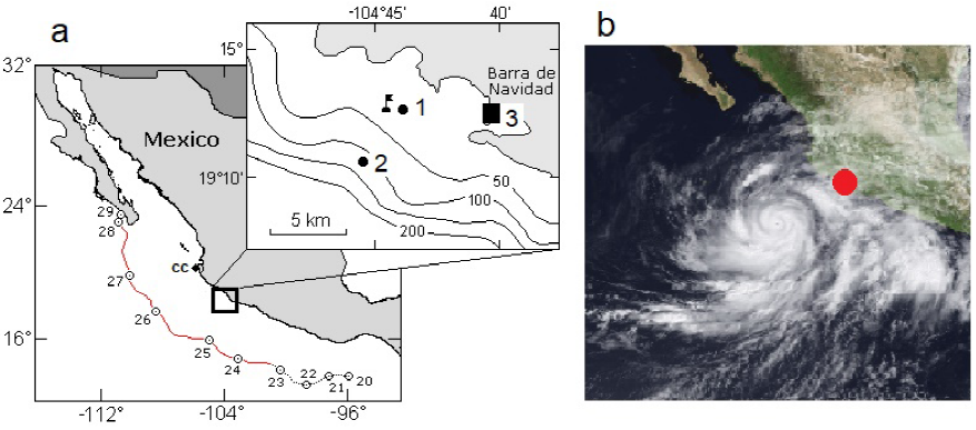
Figure 1 a) The study site, marked with a square, on the continental shelf in the central Mexican Pacific near Barra de Navidad, Jalisco, and a black arrow marking Cabo Corrientes to the north of the study site, with the trajectory of hurricane Juliette shown with the red line on different days of September 2001. The inset shows the mooring deployment of the SBE 16 (marked with a flag), the CTD profile cast sites (points 1 and 2), and the meteorological station (3) position near Barra de Navidad. b) The location of Hurricane Juliette on September 27, 2001, with the red circle showing the study site underneath the cloud cover.
Vertical water column profiles were taken with a CTD SBE-19plus (Sea Bird Electronics Inc.) on September 23, 2001, when the hurricane was 300 km to the South, and again on September 27, 2001, when the center of the hurricane had just passed and was 350 km to the Northwest.
Vertical profiles were taken at two sites on the shelf (see Figure 1), near the mooring (38 m depth, point 1), and at an offshore site, 2 km from the coast (120 m depth, point 2). Meteorological, mooring and CTD cast data were analyzed using the included instrument programs and further analyzed in Matlab 2010 (Mathworks Inc.) and Fortran 90.
Results
Tropical storm Juliette appeared on September 21, 2001, 265 km Southwest of Tapachula, Mexico (centered at approximately 13.4° N, 94° W) with a maximum wind speed of 85 km h-1, wind gusts of up to 110 km h-1 and a minimum pressure of 996 hPa (http://www.nhc.noaa.gov). On the morning of September 23, 2001, Juliette intensified to a hurricane. From September 24 to 27, 2001, Juliette maintained a predominantly West-Northwest trajectory, increasing to a Category 4 on the Saffir-Simpson scale. On the morning of September 26, wind speeds reached 230 km h-1, with gusts of 285 km h-1 and minimum pressure of 923 h Pa at a distance of approximately 430 km to the Southwest of Cabo Corrientes (in the state of Jalisco, Mexico) (Figure 1, 2).
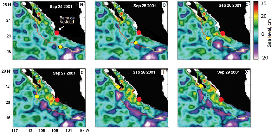
Figure 2 Sea surface height anomaly (colored contours in cm) from September 24 - 29, 2001 when Hurricane Juliette moved along the west coast of central Mexico (adapted from Zamudio et al., 2002). The red circle marks the location of the study site near Barra de Navidad, Jalisco, and the yellow hexagon indicates the position of the hurricane center for each day.
The vertical CTD profiles of temperature and salinity taken at the coast show that the pycnocline at our shallowest sampling site disappeared due to vertical and horizontal mixing after the passage of the hurricane, with a uniform layer of temperature and salinity throughout the entire water column.
This resulted in a decrease in surface temperature by 4 °C and an increase in surface salinity by 0.4 PSU, whereas at depth, the opposite pattern occurred, with similar magnitude (Figure 3a). At the deeper sampling site, surface layers also decreased in temperature and increased in salinity to 20 m depth, again with the opposite occurring below 20 m, showing a homogeneous mixed layer down to about 40 m depth (Figure 3b). The temperature and salinity profiles gradually restored their normal shape below 80 m (Figure 3b).
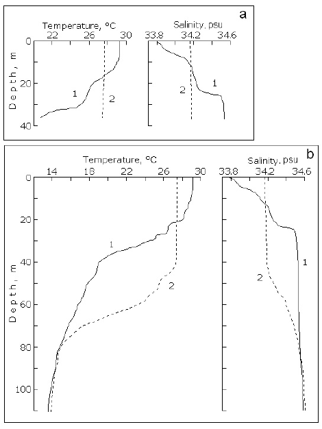
Figure 3 Temperature and salinity vertical water column profiles measured near the mooring (point 1 on Figure 1a) (a), and at the offshore site (point 2 on Figure 1a) (b), on September 23 (continuous line, marked 1) and on September 27 (dashed line, marked 2), 2001, before and after the passing of hurricane Juliette.
During the movement of the hurricane through the measurement area (see boxed area in Figure 4a-d), the wind increased from 5-7 m s-1 to more than 20 m s-1, with an average stabilized direction of 85 degrees (west), from the morning of September 25 to the afternoon of September 27 (Figure 4c, d), which contributed to the upwelling documented shortly thereafter in the water column (Figure 3a, b). At the same time, the air temperature cooled, with high clouds and a decrease in the solar radiation from 1000 to almost 230 Wm2, and a significant drop in atmospheric pressure just before the increase in the wind, on the night of September 24 (Figure 4a, b).
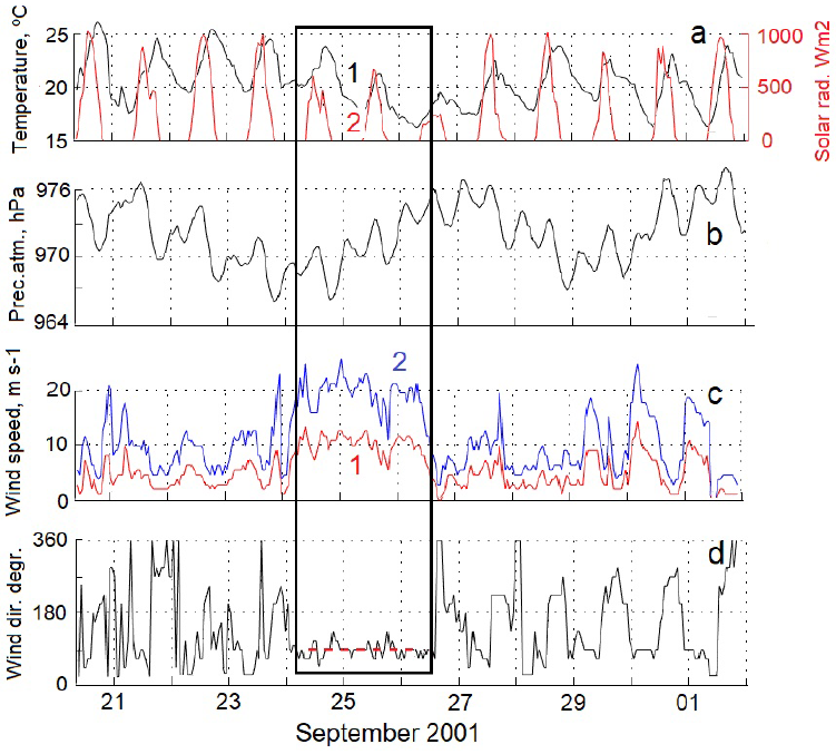
Figure 4 a) Temporal variation of air temperature (black curve, marked 1), solar radiation (red curve, marked 2), atmospheric pressure (b), wind speed (c) (with the red line marked 1 showing hourly averaged wind speed and the blue line marked 2 showing wind gusts), and wind direction (d) from an automatic weather station installed at the shore. The boxed area marks the time interval corresponding to the passage of the eastern edge of the hurricane through the study area, with the red dotted line in panel (d) showing the directional wind stability at that time.
The mooring measurements showed that sea level began to decrease slightly about four days before the arrival of the hurricane, yet by the evening of September 25, it rose abruptly by 50 cm (Figure 5a, 6a), just before the mixing of the water column resulted in the marked reduction in thermal variability and an almost uniform water layer at the depth of the moored instrument, lasting from the nights of September 25 to 27 (see boxed area in Figure 5b, c). Model calculations (see Figure 2c, e) showed coastally trapped waves present at the shelf edge on September 26 and 27, with a corresponding sea level rise of20-25 cm, and our mooring measured a total rise in sea level exceeding 1 m. The over-tiding occurred for 4 to 5 days, during the time the area was under the influence of the hurricane (Figure 6a, b).
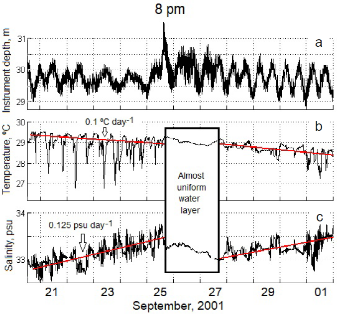
Figure 5 Time series at the mooring, measured by the SBE-16m showing, a) instrument depth, b) water temperature, and c) salinity. Instrument depth was de-tided and corrected for the atmospheric pressure load effect. The red lines in panels b and c show the general trend by smoothing with a 25-hr cosine filter. The boxed area represents the time of maximum hurricane impact off the coast of the state of Jalisco, Mexico, and clearly shows the abrupt mixing and stabilization of the water column, with reduced thermal variability during this time.
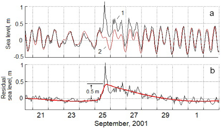
Figure 6 a) Sea level fluctuations in the mooring area showing, 1) hourly sea level fluctuations measured with the moored CTD SBE-16 in black, and, 2) predicted tidal fluctuations in red (CICESE, Mar Tidal Prediction Program, for the Manzanilla site, 25 km to the south of our instrument site), and b) residual sea level. The red line in panel (b) shows the residual level trend smoothed by a 36-hr cosine filter.
Discussion
In situ nearshore oceanographic and meteorological data taken on the coast of the Mexican Eastern Tropical Pacific during the passage of Hurricane Juliette in 2001 showed the expected pattern of upwelling, mixing, and sea level rise, with the potential effects of coastally trapped waves confounded in the sea level signal. The vertical pattern of surface cooling and warming at depth in the nearshore water column is common on the right side of the track of cyclones (Wu et al., 2020). Zamudio et al. (2010) also showed the mixed layer reaching down to 40 m depth along the Southeastern coast of the Baja California peninsula, similar to what we found, and confirmed the nearshore in situ surface cooling with the broader signature of upwelling using satellite chlorophyll measurements.
The breakdown of stratification measured in the vertical profiles resulted in a notable reduction in the thermal variability of the water column during hurricane passage in the mooring instrument time series. The variability in the water column measured prior to and after the hurricane passed showed abrupt cold-water pulses occurring at the mooring, with over 2°C temperature drops in a matter of minutes, which have been characterized previously as part of the semidiurnal internal tidal signal in this region (Filonov et al., 2000; Filonov and Konyaev, 2003; Filonov and Tereshchenko, 2003). This internal wave signal abruptly disappeared as the wave guide was broken down with the disappearance of the pycnocline and reappeared once stratification was re-established. This type of turbulent mixing is common within one radius of maximum hurricane winds, where stratification is often destroyed (Keen and Glenn, 1999), and it is well known that internal tidal fluctuations require stratified waters (Winant, 1974).
The simulated ocean level changes and position of Hurricane Juliette as it moved along the Mexican coast (Zamudio et al., 2002; 2010) showed the formation of coastally trapped waves that propagated poleward along the Pacific coast of the mainland Mexico coast and into the Gulf of California. Model calculations from Zamudio et al. (2002) show coastally trapped waves present at the edge of the shelf near our in situ study site on September 26 and 27. In our time series, we clearly see over-tides measured as an abrupt sea level rise of almost 50 cm, which coincided with a higher tide period and lasted 4 to 5 days. Unfortunately, we were unable to tease apart the role of second-order coastally trapped waves in mixing and sea level fluctuations in our measurements from the first order sea surface elevation surge effects (Hubert et al. 1991). Multilayer ocean models have been used to numerically simulate the response of the baroclinic shelf to a moving hurricane along the western coast of Mexico and the Gulf of California (Gjevik, 1991; Gjevik and Merrifield; 1993) and show similar storm response features in the shelf region, such as narrow-band oscillations of barotropic shelf waves, near the inertial period, and long periodic baroclinic wave modes. Over-tides are common during extreme atmospheric events (Paniagua-Arroyave et al., 2019), and combined approaches of both in situ measurements and modeling might help to tease apart their causes.
The results presented herein are limited yet are unique in that they expand on the models previously presented during this hurricane passage with in situ measurements taken on the open coast. Measuring in situ oceanographic changes under different atmospheric influences, such as hurricanes, is critical for informing coastal models and further understanding water column impacts of hurricanes.
Conclusion
In situ nearshore oceanographic and meteorological data on the coastline of the Mexican Eastern Tropical Pacific during the passage of Hurricane Juliette in 2001 showed the expected pattern of mixing and sea level rise, however it was difficult to separate the effects of surge from coastally trapped waves, and a combined approach of modeling and in situ data is recommended going forward. Although models are a useful approach to estimate oceanic conditions during hurricane passage when in situ measurements are difficult and dangerous to obtain, they cannot resolve hurricane effects on the shelf and very near the coast. In situ meteorological and oceanographic characteristics can fill this gap in understanding and might be particularly relevant for understanding coastal vulnerability and the coupling processes between the atmosphere and the coastal shelf off the Pacific coast of central Mexico.

