


 nueva página del texto (beta)
 Inglés (pdf)
 Artículo en XML
 Referencias del artículo
 Enviar artículo por email
 Citado por SciELO
  Similares en
SciELO
Similares en
SciELO 
 Permalink
Introduction
In response to the climate change in a global context, many glaciers are losing ice volume -and the Patagonian region is not an exception- which contributes to sea-level rise (Falaschi et al., 2017; Gardner et al., 2013; Hock et al., 2009; Jacob et al., 2012).
The largest temperate ice masses acknowledged in the southern hemisphere are also undergoing this melting process (Warren & Sugden,1993). Both the Northern and Southern Patagonian Icefields (hereafter, NPI and SPI, respectively) and their outlet glaciers, have shown high thinning rates since the second half of the 20th century (Rignot et al., 2003; Willis et al., 2012a; Willis et al., 2012b).
The evolution of satellite gravimetric missions in the last years have introduced a new concept in the gravitational field modeling, allowing to obtain accurate global models with a higher resolution of the static component and in the time-dependent gravity field. In recent years, remote sensing data (such as altimetry-based surface water levels and total water storage from space gravimetry) have proved to be very helpful for studying the water balance at sub-basin and basin scales (Bamber & Rivera, 2007; Pereira et al., 2014; Xavier et al., 2010).
The GRACE (Gravity Recovery and Climate Experiment) satellite gravity mission can map the mass distribution by measuring the changes in the Earth’s gravity field. These changes can be related to terrestrial water storage, which includes hydrological reservoir changes, snow, ice, and glaciers, and can be expressed in terms of equivalent water height (TWS). From GRACE, it is possible to detect these mass variations to a height of about 1 centimeter for areas ranging in size on the order of 400 km (Wahr et al., 2004).
There are important contributions of GRACE data in the study of ice mass losses in Greenland (Chen J. L., 2006; Jin & Zou, 2015; Su et al., 2015; Svendsen et al., 2013), the Patagonian region (Barcaza et al., 2017; Chen et al., 2007; Ciraci et al., 2015; Falaschi et al., 2017; Millan et al., 2019; Richter et al., 2019), the glaciers of the Tian Shan mountain chain (Yi et al., 2016), Alaska (Chen J. L., 2006), and Antarctica (Jin et al., 2016; Lee et al., 2012).
Satellite altimetry and GRACE mission have been used to monitor the components of the water balance in large river basins over time scales ranging from months to decades. Space observations allow to obtain unprecedented information in combination with terrestrial data, providing global coverage, and continuous monitoring over time. In addition, they have the potential to significantly improve the understanding of hydrological processes in large river basins and their influence on climate variability.
Satellite altimetry allows the systematic monitoring of the oceans, rivers, lakes, wetlands, and flood plains water level (Papa et al., 2008). Several satellites have been launched since the ‘90s, like ERS-1 (1991), TOPEX/POSEIDON (1992), ERS-2 (1995), GFO (2000), Jason-1 (2001), ENVISAT (2002), and Jason-2 (2008).
In recent decades, most Patagonian glaciers have retrogressed alarmingly fast with high decrease rates (Rivera & Casassa, 2002). Several studies about mass losses in the Patagonian icefield have been developed (Abdel et al., 2019), like Rignot (2003), who estimated an ice loss of 15.0 ± 0.8 km3 per year for the period 1975- 2000 (total amount in the northern and southern region). For the period 1995- 2000, this research estimated losses of about 37.7 ± 4.0 km3 per year, which gives an idea of the accelerated ice melting in the last years.
The Intergovernmental Panel on Climate Change showed that since 1960 the accumulated losses in the Patagonian glaciers were about 40 m of ice thickness (Lemke et al., 2007).
It is difficult to obtain the estimates of the ice loss for North and South Patagonian Icefields for several reasons, but mainly due to the lack of observations with adequate spatial and temporal sampling. The relatively small size of the region, the gradient of the slopes, and the undefined boundaries of the glaciers limit the utility of remote sensing techniques, such as laser or radar altimetry and interferometric synthetic aperture radar -InSAR- (Coudrain et al., 2005; Braun et al., 2019; Papa et al., 2008).
There are multiple impacts associated with massive losses of glaciers and permanent icefields. One of the most direct consequences is the rise of sea levels due to the incorporation of a large amount of water from the ice melting. In addition, the loss of large ice areas implicates the loss of the reflective surface of the Earth as well, which will increase the warming due to an increment of the solar radiation absorbed by the Earth's surface (Gardner et al., 2013).
The objective of this work is to detect the total water storage variations (TWS) in the Patagonian Icefield from GRACE data, together with the estimation of the decreasing trend for the NPI and SPI regions corresponding to the 2002-2017 period. Moreover, the water level variations in Patagonian lakes are analyzed using a combination of GRACE and satellite altimetry data with in situ measurements.
Study area
The glaciers have an important role in global freshwater storage since almost 70% of the world’s freshwater is stored in glacial ice (Chen et al., 2007). The icefields are vast rocky areas covered by ice sheets that comprise different geographical features, such as lakes and large mountain chains. According to geological and glaciological studies, the icefields would be remnants of areas formed during the last glaciation. These icefields also represent one of the main freshwater reservoirs in the world.
The main icefields in the Patagonian region are, on one hand, the Northern Patagonian Icefield (NPI), which is an ice mass that covers an area of 4,200 km2 (Figure 1) and is entirely located in Chile. The Arenales Hill and San Valentín Mount, both covered by glaciers, are important because of their height of 3,437 and 3,910 meters, respectively. On the other hand, the Southern Patagonian Icefield (SPI), which is a large continental ice region located on the border between Argentina and Chile and covers an area of 13,000 km2 (Figure 1). Numerous large glaciers arise from this, like the Montt, Pío XI (the largest of South America), Grey, Upsala, Viedma, and Perito Moreno. It is estimated that the SPI consists of 48 major glaciers and more than 100 minor glaciers.
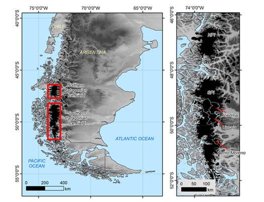
Figure. 1 Northern Patagonian Icefield (NPI) and Southern Patagonian Icefield (SPI) locations (left); and a detail of some glaciers in the region (right). The maps were generated with information from GLIMS Glacier Database (Raup et al., 2007).
In the Patagonian Andes, a large lake system can be found. Among the largest lakes in this system, the Buenos Aires/General Carrera, St. Martín/ O'Higgins, Viedma, and Argentino can be mentioned.
Data
GRACE Data
The observed gravity variations are caused by temporal mass changes. These mass variations can be considered as concentrated in a very thin water layer on the surface, with thickness changing in time. In fact, most of the temporal gravity variations are caused by changes in the water storage of the hydrological reservoirs, by mass movements in the oceans, atmosphere and cryosphere, and by the exchanges between them. The vertical extension of this layer of water is measured in centimeters, which is much smaller than the Earth’s ratio or the horizontal variations scales -which are measured in kilometers- (Wahr et al., 1998).
First, the GRACE Level-2 data corresponding to the period spanning from April 2002 to June 2017 were used for gravity trend analysis. Particularly, the solutions from CSR RL06 (Center for Space Research, University of Texas) were acquired (Bettadpur S., 2018).
Afterwards, the high-resolution GRACE CSR RL05 mascon solutions were used in this study in order to analyze the water mass variations of the Patagonian Icefields (Save et al., 2016).
A mascon solution approach consists of a mass anomalies estimation at grid locations of certain mass concentration. Then, these solutions provide the monthly time variations of the TWS at 1° of spatial resolution, resampled at 0.5°. Only GRACE measurements are used to derive these solutions, and they are not influenced by external geophysical models or data. In this approach, the mascons are related to the range-rate or the range-acceleration data by means of a spherical harmonic expansion, which is truncated at a finite order and degree (Save et al., 2016).
In Situ Measurements
The National Hydrological Network is the largest source of hydrological information in Argentina and collects the basic data required for the design of projects and the national management of water resources. It is currently operated by several national institutions and has 369 measuring points, in many of which both hydrological and meteorological parameters are observed (SSRH, 2018).
The Basic Network of Water Information collects and processes the basic data of the quantity and quality of water resources with a significant presence in most part of the country, and provides hydrological information, which is available to the user through the development and implementation of the National System of Water Information (SNIH)
In this work, three stations with in situ water level measurements and daily time resolution were selected. These stations are located at the Argentino, Rico and Buenos Aires lakes (Figure 2), and their characteristics are shown in Table I.
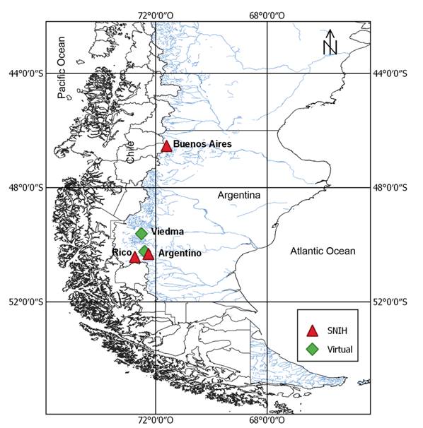
Figure 2 Virtual (green) and SNIH (red) stations at the Patagonian lakes: Buenos Aires corresponds to the NPI region; Argentino, Viedma and Rico, to the SPI.
Table I Virtual and terrestrial stations characteristics used in this study.
| Lake | Latitude | Longitude | Icefield | Source |
|---|---|---|---|---|
| Buenos Aires | 46.5388 S | 71.6097 W | NPI | SNIH |
| Rico | 50.4261 S | 72.7478 W | SPI | SNIH |
| Argentino | 50.3200 S | 72.2610 W | SPI | SNIH |
| Argentino | 50.2408 S | 72.3985 W | SPI | Virtual |
| Viedma | 49.6155 S | 72.5125 W | SPI | Virtual |
The Buenos Aires station presented a lack of information in the period under study; however, it was still included since it was the only one located at the NPI.
Satellite Altimetry Data
Satellite altimetry is a technique that has great potential in hydrology, and for a lot of lakes located in areas that are difficult to access, it is the only source of information available.
The RADAR (Radio Detection and Ranging) altimeters used in satellite missions transmit a short microwave pulse in the nadir direction. The distance traveled by the electromagnetic pulse between the satellite and the Earth's surface is determined by measuring the time it takes for the pulse to be reflected back to the altimeter, assuming that the pulse propagates at the speed of light (Calmant et al., 2008).
Then, the height of the reflecting surface is calculated by the difference between the satellite orbit and the altimeter range measurement. Several corrections in which time delays related to the propagation of the pulse through the atmosphere and the ionosphere are considered, as well as also corrections for solid tidal effects on the Earth, are after added.
Nowadays, there are several databases that allow obtaining the hydrometric heights in large basins of the world. The satellite water level information used in this work was obtained from DAHITI (Database for Hydrological Time Series of Inland Waters), which provides water level time series of lakes, reservoirs, rivers, and wetlands derived from multi-mission satellite altimetry for hydrological applications (Schwatke et al., 2015). For the estimation of water heights, multi-mission altimeter data are used, such as Topex, Jason-1, Jason-2, Jason-3, Envisat, ERS-1, ERS-2, Cryosat-2, IceSAT, Sentinel-3A and Sentinel-3B.
In this study, two satellite altimetry virtual stations were selected from the DAHITI website, located at the Viedma and Argentino lakes (Figure 2 and Table I).
Methodology and Results
Gravity Trend and Amplitude
The changes in time of the monthly gravity fields, (g, were determined by means of a 4-parameter trend analysis of the gravity disturbances. In order to do this, the trend and two yearly seasonal terms were estimated in each grid point of 0.5° x 0.5° (Sandberg Sørensen & Forsberg, 2010), where the result is the gravity trend obtained at satellite altitude (500 km):
First, a grid for the Patagonian Icefield region was determined, considering the area between 52º - 45º south latitude, and 75º - 71º west longitude.
To allow a fair comparison and limit the errors introduced to the high order coefficients, in all cases the data was filtered by truncating the spherical harmonic expansions (Forsberg & Reeh, 2006; Sandberg Sørensen & Forsberg, 2010). The calculations were essentially performed with the geodetic software Gravsoft (Tscherning et al., 1992).
The resulting gravity trend (in μGal per year) for the area under study, based on GRACE Level-2 solutions, is shown in Figure 3.
In the Patagonian Icefield region, the gravity anomaly trend was negative for the entire area, with values ranging from -0.32 to -0.20 μGal/year. According to Figure 3, extreme values could be detected at the Southern Patagonian Icefield, in the proximity of the Viedma, Argentino and Rico lakes, delimited in Figure 2 from north to south, respectively.

Patagonian Icefield Decrease Trend
In order to analyze the NPI and SPI regions, time series of TWS from CSR mascon solutions were obtained by averaging the points of the grid contained within the delimited boundary for each region.
In Figures 4 and 5, the TWS time series for the north and south regions are presented, respectively. Linear least squares trends of TWS were obtained for the north and south region, resulting trends of ~ - 61.70 ± 3.8 mm/year and ~ - 57.90 ± 3.4 mm/year, respectively.

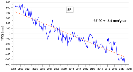
The SPI shows a more pronounced negative trend line than the NPI region, which indicates a greater speed of level melting of ice masses towards the south (about 4 cm/year).
It should be noted that these water mass change values, interpreted as ice melting, may be influenced by other causes that contribute to the mass variation, which is also detected by GRACE, e.g. groundwater storage fluctuations in nearby areas.
Chen et al. (2007) carried out a study on the melting rate of the ice mass for the whole region during the period 2002- 2006 and estimated a value of 27.9 ± 11 km3/year, which is rather high considering the small extension of the Patagonian Ice region. This estimate contributes to a sea level rise of approximately 0.078 ± 0.031 mm/year. These values obtained from GRACE are comparable with other estimations of the melt rate obtained from topographic and cartographic data made by Rignot et al. (2003).
In this investigation, no rate estimates were made, as there are other geophysical contributions to GRACE observations that have an effect on the mass variations for this area specifically, such as the postglacial rebound of the Earth's mantle due to the change in the ice load from the last maximum glaciations up to the present day ice melting. In this sense, it is not object of the present investigation to estimate rates of decrease; the study is then limited to the analysis of the GRACE signals for each region, considering that the greater mass variation is due to the melting of glaciers, but there are other contributions to that change, as mentioned above.
Chen (2006) also estimated the slope of TWS for a point located at the Pío XI glacier - one of the largest glaciers in the southern Patagonian ice region - resulting 37.4 ± 2.1 cm/year for a 5-year period. Although the results are not similar, the TWS trend values obtained in this research are not so distinct from each other, considering that the regions are different, as well as the methodology used in each investigation.
TWS monthly maps were derived from GRACE CSR RL05 mascons for the period 2002 to 2017. The mean annual TWS was also obtained, taking into account the available GRACE months (e.g. for 2017 year, the mean was obtained up to June).
Figure 6 presents the mean annual TWS maps, where the progressive decreasing of the TWS in the NPI and SPI area from 2002 to 2017 can be observed.

Comparison at Patagonian Lakes
For the sake of analysis of the TWS results from GRACE in the glacier´s area, such results were compared with hydrometric heights series and satellite altimetry data of Patagonian lakes located in Argentina and Chile.
The in situ river gauge time series (SNIH) and the virtual stations from satellite altimetry of 30 day intervals were computed in two steps in order to make the data consistent with the TWS data derived from GRACE. First, the missing data series were completed using moving averages; and subsequently, the averages for 30 days intervals were obtained. The TWS temporal series were then interpolated to obtain the water storage at the same hydrometric station (HH) with bilinear interpolation using the nearest neighbor method.
In Figures 7 and 8, the series of hydrometric height (from SNIH) and the virtual station (from DAHITI) are presented respectively together with the GRACE time series. It can be observed for all the stations that the TWS signal is decreasing in the period 2002-2017, while the water level of the lakes shows a periodic behavior. Furthermore, the seasonal performance and the adjusted trend line for the TWS and the water level series are presented in Figure 7 (right), where the increasing of both variables can be perceived, starting in the summer (of southern hemisphere) to the early autumn, in correspondence with the precipitation regime of the region.
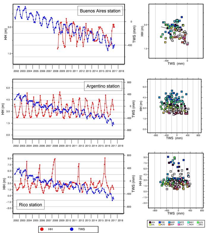
Figure7. Hydrometric height (HH) vs. TWS, trend line and seasonal behavior for both signals, for stations Buenos Aires (NPI), Argentino (SPI), and Rico (SPI).
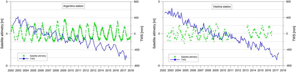
Figure 8 Water level (virtual stations from satellite altimetry) vs. TWS for Argentino and Viedma stations.
Afterwards, the Pearson coefficient r was obtained to evaluate the correlation between the analyzed variables.
At this point, it is important to mention that the TWS data and the hydrometric heights represent different magnitudes. While GRACE "sees" the total water storage as a vertical column composed of surface water, groundwater and soil moisture integrated over a time period (monthly), the hydrometric height represents the water level reached in a section of a lake that can be measured on a daily basis.
The resulting Pearson coefficients for the stations at the Patagonian lakes are shown in Table II. According to the results, the Argentino station (SNIH), located at SPI, presented the highest correlation value (over 50%). The remaining stations located in the south, both terrestrial and virtual, showed very low r coefficients; while the only one station at NPI -Buenos Aires- presented a Pearson correlation value close to 0.50.
Discussion and Conclusions
At the Patagonian region, the negative trend of the detected gravity anomalies could be mainly due to the redistribution of water, ice, and snow, and related to the climate change that is causing regression and loss of the ice mass in most of the Patagonian glaciers.
The analysis of the Patagonian Icefield area was performed for two sub-regions, the Northern Patagonian Icefield (NPI) and the Southern Patagonian Icefield (SPI). Then, the time series of TWS were obtained for each region by averaging the grid points within the boundaries for the NPI and SPI areas.
The results showed that the SPI region presents a more pronounced negative trend than the NPI region, which indicates a greater speed of the level melting of ice masses towards the south. Linear trends of total water storage were obtained for the north and south regions, resulting in values of -61.70 mm/year and -57.90 mm/year, respectively. Likewise, this negative trend was also demonstrated in the TWS maps, which showed the progressive total water storage decrease for the period 2002-2017.
According to the study of the Patagonian lakes, the SNIH stations Buenos Aires and Argentino presented a strong negative correlation -of about 0.5-. Meanwhile, for the rest of the stations located at the SPI (both terrestrial and virtual) very low correlation coefficients were obtained. The results for the SNIH stations indicate a negative association, which is revealed through the behavior of the different TWS (decreasing) and hydrometric height (mainly seasonal) signals.
The weak correlation obtained for some stations in the Patagonian lakes may be due to the influence of the nearby glaciers. The GRACE signal indicates a negative trend in the TWS, while the hydrometric level signal does not detect the same decrease. This indicates that GRACE measurements may be affected by the proximity of other zones with different hydrological characteristics.
It can be concluded that the use of GRACE data and satellite altimetry is feasible to detect variations of the hydrometric levels in the Patagonian lakes only in those areas where there is no influence of the environment. That is to say, if the surrounding area is homogeneous, then the changes in the regional water mass may be linked to punctual variations to make valid comparisons with local variables, as in the case of a gauge station (hydrometric heights). Otherwise, GRACE detects the lake- glacier water storage change, but it is not comparable with changes in the levels of the lake measured in situ or by satellite altimetry in the South Patagonian region. This means that the glacier signal derived from GRACE was stronger, masking all other signals in its neighborhood. Therefore, further investigations in this topic should be carried out.
Regarding satellite altimetry, it can be mentioned that it is useful for the comparison of GRACE results in those places where there are no in situ available information. In such comparisons, since no records were obtained in order to complement this analysis, the groundwater variations were not taken into account.

