nova página do texto(beta)
 Inglês (pdf)
 Artigo em XML
 Referências do artigo
 Enviar este artigo por email
 Citado por SciELO
  Similares em
SciELO
Similares em
SciELO 
 Permalink
Introduction
The management of volcanic risk must be supported by a variety of information elements that permits the decision making during an event of volcanic crisis. A useful approach to such management requires that the information elements are defined and prepared well in advance of a potential volcanic activity. For instance, together with hazard maps, it is essential to consider, and analyze, the likely scenarios that may occur in a potential crisis.
Another important crisis-management tool is the event tree (Newhall and Hoblitt 2002), and the more probabilistically oriented Bayesian Event Tree (Marzocchi et al., 2008). Such tools assign probabilities to the scenarios inferred from the hazards maps according to the progression of the volcanic activity. An application of the event-tree analysis to the hazard assessment of a specific type of pyroclastic flows at Arenal Volcano in Costa Rica is illustrated in Meloy (2006), who estimated the occurrence probabilities of possible eruptive events based on the activity of previous years. Similarly, Martí et al. (2008) developed a risk event tree for Teide-Pico Viejo volcanoes (Canary Islands, Spain), which also involved geology, eruptive history and present activity, as a useful tool for decision-making by civil protection authorities. Neri et al. (2008), and Sandri et al. (2009) applied event-tree methodologies to Vesuvius Volcano in Italy, extending the event concatenation from precursors along a progressive activity, then focusing on diverse eruption types and associated phenomena, such as ballistics ejection, lava flows, lahars, collapses and tsunamis in the Naples coastal zone and surrounding area. The tree branching was based on the eruptive record and data from the ongoing monitoring. Ideally, the integral management of the volcanic risk should include extensions of the event tree to describe the possible crisis scenarios and the corresponding methods of management.
However, studies focused on the management of volcanic crises are not as profuse in the scientific literature as those mentioned previously to assess the volcanic hazards. Managing a major emergency is a very complex task, and requires the deployment of considerable resources.
Frequently, evacuations are prompted by diverse circumstances, including: incorrect perception of the hazard by the threatened population and civil authorities, and failures of the response systems (Kent 1994, Leonard et al. 2008, Marrero et al. 2013); inadequate emergency plans (Sorensen 2000, Solana et al. 2008, Marrero et al. 2012); lack of protocols (Mener 2007, Solana et al. 2008); deficiencies in the communication of alerts, warnings and instructions (De la Cruz-Reyna and Tilling 2008, Paton et al. 2008, Haynes et al. 2008, Johannesdottir and Gisladottir 2010).
In this work we describe some methods to develop a vulnerability-based risk assessment methods of the threatened areas surrounding Popocatépetl Volcano, aiming to support decision-making during the ongoing volcanic crisis. The proposed methods would be compatible with a branching method to be inserted in an integral-management event tree (Newhall and Hoblitt 2002, Marzocchi et al. 2008, Sandri et al. 2009). Figure 1 shows an example of an event tree that initiates from a condition of low-level background activity at Popocatepetl volcano, and the branches represent subsequent events according to possible paths of activity evolution, according to the past events reaching a possible outcome, in this case the maximum observed event of December 2000-January 2001.
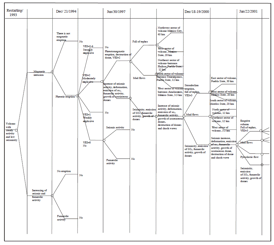
Figure 1 Example of an event tree for Popocatépetl Volcano, according to the methodology of Newhall and Hoblitt (2002) that starting from a background condition, it evolves to different conditions from 1993 until 2001.
Popocatépetl Volcano
Popocatépetl Volcano, rising 5,452 m. a. s. l., is located at 19⁰ 01.38' N and 98⁰ 3 7.29' W, on the southern end of the Sierra Nevada, which separates the valleys of Mexico and Puebla. The recent eruptive history of this volcanic edifice begins 23,000 years B.P, when the pre-existing ancestral Popocatépetl collapsed, generating massive debris avalanches (Robin and Boudal 1987; Boudal and Robin 1989; Siebe et al., 1995). Since then, its activity has been characterized by several major explosive eruptions and many smaller eruptions. The most recent explosive eruptions occured ca. 3000 B.C., between 800 and 200 B.C., and ca. 800 A. D. (Siebe et al., 1996; Siebe and Macias 2004). Afterwards, the activity of Popocatépetl has remained moderate for nearly 1,200 years. Historical reports since 1354 describe at least 19 episodes of activity, some of which probably involved dome growth-and-destruction processes similar to those of the current, ongoing activity (De la Cruz-Reyna et al., 1995; De la Cruz-Reyna and Tilling 2008, De la Cruz-Reyna et al., 2017).
The proximity of Popocatépetl with large population centers (Table 1) such as The Metropolitan Area of Valley of Mexico to the NW; Puebla City, 42 kilometers to the NE; Cuernavaca City, 65 kilometers to the SW (INEGI, 2010); and a myriad of smaller settlements in the States of Mexico, Morelos, and Puebla, with the above mentioned diversity of eruptive styles makes Popocatépetl a high risk volcano. It is therefore necessary to continue developing, and refining, decision-making tools to reduce risk, in the event of a possible future major escalation in the ongoing crisis. Popocatépetl's most recent eruptive activity previous to the current 1994-present episode was during 1919-1927, which has been described in detail by several authors (Waitz 1920b, 1921; Weitzberg, 1922, 1923; Camacho, 1925; Atl, 1939; Gómez-Vázquez A. et al., 2016). The 1919-1927 activity has helped to define the lower bound of the most likely scenarios for evolution of the present activity.
Table 1 Areas influenced by the activity of the Popocatépetl Volcano and its corresponding populations (INEGI, 2010).
| Zone | Population |
|---|---|
| Metropolitan area of Valley of Mexico | 19,764,540 |
| Puebla City | 1,539,819 |
| Cuernavaca City | 365,168 |
| Myriad of smaller settlements, in the States of Mexico, Morelos, and Puebla | 1,040,979 |
Methodology
To carry out a vulnerability-based risk assessment in a readily accessible platform we use Google Earth (Google™ Earth, V 7.1.5 1557), since its easy of use, and has a wide accessibility to the general public. To do this, all the field information is incorporated in the same platform, which can be interacted with new field information that may arise over time.
We selected a quadrant (Figure 2) that delimits a sufficient area to include the risk areas shown on the hazard map of Popocatépetl Volcano (Macias et al., 1995a; Arana et al., 2016). Within that quadrant (indicated by red rectangle) the following parameters of information are included:
The areas with high, medium, and low risk, are delimited by digitized red, orange and yellow lines, respectively.
The villages of high risk for the three states (indicated by red squares in Figure 3, are located within the area bounded by the red line. Digital information for each village includes: its official name and municipality; geographic coordinates and altitude above sea level; their most recent population according to the emergency planning map; their meeting place with address; the alerting device; the detailed evacuation route to its designated temporary shelter with address and capacities; distance in km to the shelter and travel time in minutes from the village to its designated shelter. The latter may vary depending on weather conditions.
The villages of medium risk (indicated by orange squares) are represented in the zone between the orange and red lines (Figure 4). Each of these villages includes the same type information as in (b).
The villages of low risk (indicated by green squares) are represented in the zone between the yellow and orange lines (Figure 5). Each village also includes the same type of information as in (b).
Figure 6 shows the most important drainages capable of channeling lahars (marked in dark blue), as well as the communities (blue squares) exposed to this hazard; some larger communities also appear as polygons (light blue). Each community includes the same type of information as in (b), but it also includes the populations bordering the valley that must move to higher ground in case of mudflows.
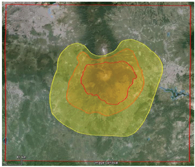
Figure 2 Quadrant delimited by points P1(190 27' N, 990 16' W; P2(190 27' N, 980 05' W); P3(180 30' N, 990 16' W) and P4(180 30' N, 980 05' W) covering a sufficient area to include the hazard map of the Popocatépetl Volcano (Macias et al., 1995a, Arana et al., 2016).
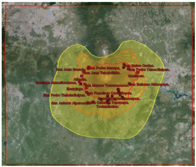

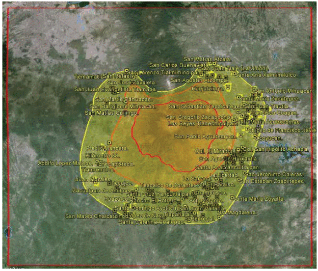
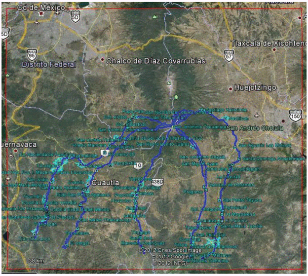
Figure 6 The most important drainages from the point of view of potential risk from lahars in México, Morelos and Puebla States. All dataused in these maps were obtained in the field through direct visits to each town in the area. Each of the evacuation routes was tracked directly in the field to identify the optimum traffic control points.
Eruptive period, from December 21, 1994 to the present
The most important features of the current eruptive episode of Popocatépetl are summarized in Table 2 (Appendix 1), in reverse chronological order from 2017 to 1994. The analysis and communications of such features have influenced the perceptions of the volcanic hazards among the population and civil authorities, their reactions to different levels of activity and the choice of meeting places, escape routes and shelter locations, which in addition to the available hazard maps (Macias et al., 1995a; Arana et al., 2016) provided the basic data and criteria utilized in this present work.
Settlements within high-risk areas around Popocatépetl Volcano
The villages located within the high-hazard areas around Popocatépetl Volcano are as follows: Eight in the State of México (Table 3), two in the State of Morelos (Table 4) and twenty in the State of Puebla (Table 5).
Table 3 Villages with high risk in State of México.
| VILLAGE | MUNICIPALITY | RISK SECTOR | POPULATION |
|---|---|---|---|
| San Pedro Nexapa | Amecameca | 1-7 | 4,633 |
| San Juan Grande | Amecameca | 1-7 | 429 |
| Atlautla de Victoria | Atlautla | 1-7 | 10,967 |
| San Juan Tehuixtitlán | Atlautla | 1-7 | 6,743 |
| San Juan Tepecoculco | Atlautla | 1-7 | 3,790 |
| Ecatzingo de Hidalgo | Ecatzingo | 1-7 | 7,058 |
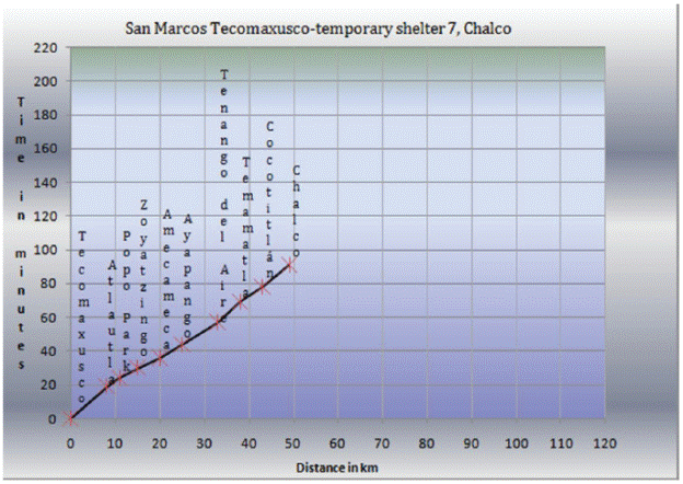
| San Marcos Tecomaxusco | Ecatzingo | 1-7 | 1,022 |
| Santiago Mamalhuazuca | Ozumba | 1-7 | 2,182 |
| Total: 8 | 4 | 36,824 |
Information taken from INEGI, 2010.
Table 4 Villages with high risk in Morelos State.
| VILLAGE | MUNICIPALITY | RISK SECTOR | POPULATION |
|---|---|---|---|
| San Francisco Ocoxaltepec | Ocuituco | 1-6 | 1,338 |
| San Pedro Tlalmimilulpan | Tetela del Volcán | 1-6 | 1,637 |
| Total: 2 | 2 | 2,975 |
Information taken from INEGI, 2010.
Table 5 Villages with high risk in Puebla State.
| VILLAGE | MUNICIPALITY | RISK SECTOR | POPULATION |
|---|---|---|---|
| San Mateo Ozolco | Calpan | 1-2 | 2,713 |
| San Nicolás de los Ranchos | San Nicolás de los Ranchos | 1-2 | 5,685 |
| San Pedro Yancuitlalpan | San Nicolás de los Ranchos | 1-2 | 2,694 |
| Santiago Xalitzintla | San Nicolás de los Ranchos | 1-2 | 2,196 |
| San Baltazar Atlimeyaya | Tianguismanalco | 1-3 | 1,104 |
| San Pedro Atlixco | Tianguismanalco | 1-3 | 867 |
| San Pedro Benito Juárez | Atlixco | 1-3 | 3,153 |
| San Juan Ocotepec | Atlixco | 1-3 | 825 |
| Colonia Agricola Ocotepec | Atlixco | 1-3 | 1,898 |
| Guadalupe Huexocoapan | Atlixco | 1-3 | 442 |
| San Miguel Ayala | Atlixco | 1-3 | 1,628 |
| San Jerónimo Coyula | Atlixco | 1-3 | 6,622 |
| Tochimilco | Tochimilco | 1-4 | 3,289 |
| La Magdalena Yancuitlalpan | Tochimilco | 1-4 | 2,210 |
| San Martin Zacatempan | Tochimilco | 1-4 | 721 |
| San Miguel Tecuanipan | Tochimilco | 1-4 | 1,378 |
| Santa Catalina Cuilotepec | Tochimilco | 1-4 | 439 |
| Santa Catarina Tepanapa | Tochimilco | 1-4 | 681 |
| Santa Cruz Cuautomatitla | Tochimilco | 1-4 | 1,405 |
| Santiago Tochimizolco | Tochimilco | 1-4 | 747 |
| Total: 20 | 6 | 40,697 |
Information taken from INEGI, 2010.
Operational (response) plans for Popocatépetl Volcano
When the most recent activity of Popocatépetl began, on December 21, 1994, the States of Mexico, Morelos, and Puebla States began to develope their respective response operational plans within the framework of the National System of Civil Protection, involving the three levels of government: federal, state and municipal, and the social and private sectors of each state (Figure 7).
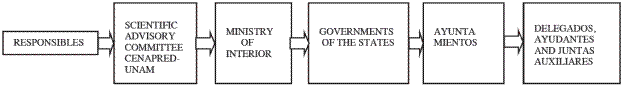
In such operational plans, all participating offices are governed according to liability matrices defining their specific functions, under the constitutional headship of the Governor of each state. Such governance includes the emergency coordination, emergency plans, warning, evacuation, temporary shelters, public safety, supplies, strategic services, equipment and goods, search of missing people, rescue and assistance, medical attention, damage assessment and emergency social communications. Since Civil Protection authorities may change when are state elections (usually every 6 years), occur one of the objectives of the present work is to maintain the conceptual framework to help new officials in understanding and implementing the operational plans.
Temporary shelters
The sites to serve as temporary shelters -in case of volcanic emergency- in the states of México, Morelos, and Puebla were selected in different localities (Figure 8), necessarily outside the volcanic risk area. The shelters for the same three states which are generally schools are indicated as green small house icons with a flag, with their geographical location, height above sea level, address and capacity.
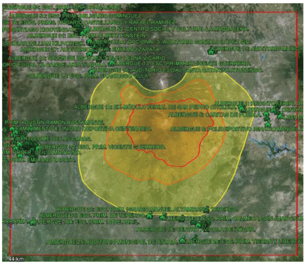
Figure 8 Locations of the temporary shelters of the States of México, Morelos and Puebla, which are outside the risk area.
A prime prerequisite for their selection was that they had the necessary infrastructure to provide the necessities and services required by the expected amount of people during their stay, such as: drinking water, electricity, telephone, toilets, showers, sleeping area, kitchen area and mess halls; recreational areas, medical service, psychological support, and religious and worship services. The establishments that were considered for use during a possible contingency include schools of all levels (from kindergarten to high schools), CONALEP (National College of Technical Vocational Education), CEBETIS (Center for Technical, Industrial and Services Studies), gymnasiums, halls of multiple uses, social and cultural centers, municipal and farmer halls; exhibition fairs sites, sports center sites, trade union buildings, Rotary and Lion clubs, among others. The number and capacities of the temporary shelters of the States of México, Morelos, and Puebla are summarized in Table 6.
Table 6 Temporary shelters established in México, Morelos, and Puebla States. (Tabulated from data in: Plan Operativo Popocatépetl (2012); Plan Fuerza de Tarea Popocatépetl (2001); Plan de Protección Civil para el Volcán Popocatépetl (2000); Programa Especial para la Emergencia del Volcán Popocatépetl (2007).
| STATE | TOTAL NUMBER OF SHELTERS | TOTAL CAPACITY (PEOPLE) |
|---|---|---|
| Edo. Mex. | 114 | 34,830 |
| Morelos | 42 | 12,048 |
| Puebla | 34 | 38,561 |
| Total: 3 | 190 | 85,439 |
Note: Additionally, for Puebla State temporary shelters are contemplated for 237 schools in Puebla municipality, 33 schools in San Pedro Cholula municipality, six schools in San Martin Texmelucan and 67 schools in Izúcar de Matamoros municipality.
Response and evacuations during the eruptive episode of December 18-19, 2000
On December 18-19, 2000, Popocatépetl activity occured and a contingency situation was developed. The available operational plans for each of the States at the time allowed to deal with that contingency. However, some difficulties arose during the contingency, particularly the overreactions in some towns; these problems were among the reasons to undertake the present study. The plans required, as a first stepts, rais the awareness of the risks related to volcanic activity, among the populations of the three States, through talks, lectures, brochures, calendars, evacuation drills (at least three in México State, eight in Puebla, and five in Morelos in 2000), radio spots at the most popular broadcasting stations in high-risk areas, and improvement of roads and highways with the construction of some bridges and beltways like in Atlautla, State of México. Additionally, there were early agreements reached with associations of taxis and minibuses, commercial carriers and private vehicles that could be used at for evacuation, in the case of a contingency.
The increase in volcanic activity, the associated intensity in the volcano-monitoring, and the persistence of energetic harmonic tremor, prompted the Scientific Advisory Committee (SAC) to recommend to the authorities of the National Coordination of Civil Protection of SEGOB to rise the level of alert, particularly for the most vulnerable communities at risk, considering the increased probability of a major eruptive event. The SAC advised that such activity may pose a threat on settlements located in zone 1 of higher risk, according to the existing map of hazards of Popocatépetl (Macias et al. 1995a). In addition the SAC noted the increasing probability of damage to settlements located along river valleys that could channel destructive lahars. Such lahars potentially could be generated by erosion and melting of glaciers in the north and northwest sectors of the volcanic cone caused by potential pyroclastic flows.
Therefore, on December 15, 2000, a declaration of emergency was issued in the Diario Oficial de la Federación (2000) that involved the release of funds from the Emergency Reserve of Fund for the Emergency Care (FONDEN) (http://www.proteccioncivil.gob.mx/work/models/ProteccionCivil/Resource/21/12/images/Definicion%20del%20FAE.pdf). Accordingly, the three States, through their State Systems of Civil Protection (General Directorate of Civil Protection in México State, General Directorate of Civil Protection in Morelos State, and State System of Civil Protection in Puebla), coordinated with the federal Civil Protection to start evacuation operations. These actions involved: 13 communities in the México State (with 28,539 persons); three communities in the State of Morelos (with 2,720 persons), and 20 communities in six municipalities of the State of Puebla (with 55,281 inhabitants). Of the total of 86,540 persons affected, 8,592 people who were transported via 13 evacuation routes remained at 23 temporary shelters of the México State (Memoria de las Acciones del Plan Operativo Volcán Popocatépetl del 15 al 27 de Diciembre del año 2000). In the State of Morelos, four temporary shelters and four evacuation routes were used to transport and accommodate a total of 2,664 people (Contingencia Volcánica Morelos, Diciembre 2000); and the State of Puebla housed 8,289 people in 23 shelters, transported via 10 evacuation routes (Resumen de las acciones llevadas a cabo durante la evacuación de las comunidades aledañas al volcán Popocatépetl en Diciembre de 2000). Of the remaining population (nearly 66,995), some self-evacuated to other places, mainly to homes of friends or relatives outside the risk areas, while others decided not to leave. In high-risk areas of the State of Puebla, about 1,598 people expressed their reluctance to leave (Resumen de las acciones llevadas a cabo durante la evacuación de las comunidades aledañas al volcán Popocatépetl en Diciembre de 2000), while in the State of México 11,360 people were not evacuated (Memoria de las Acciones del Plan Operativo Volcán Popocatépetl del 15 al 27 de Diciembre del año 2000). There is no report from Morelos State.
In the areas of highest risk, 20 towns in Puebla State, 8 in México State, and 2 in Morelos State were evacuated; in areas of intermediate risk, also 5 towns in México State, 1 in Puebla State, and 2 in Morelos State were evacuated. In addition, the San Buenaventura Nealtican community in Puebla was evacuated, because it was in the lahar flow path along the Huiloac ravine, which originates on the north side of the volcanic cone, at the glacier which potentially could be eroded and melted by pyroclastic flows. In México State, San Diego Huehuecalco, San Juan Tlacotompa, San Andrés Tlalámatl, Colonia Guadalupe Hidalgo and San José Tlacotitlán (Memoria de las Acciones del Plan Operativo Volcán Popocatépetl del 15 al 27 de Diciembre del año 2000); and in Morelos Huecahuaxco and Hueyapan were also evaluated (Contingencia Volcánica-Morelos Diciembre 2000).
Evacuation operations began in all the towns simultaneously on December 15, 2000, and involved the respective State Units of civil protection, the National Coordination of Civil Protection of SEGOB, and the National Center of Disaster Prevention. The Scientific Advisory Committee closely followd the evolution of the volcanic activity.
The eruption reached its maximum intensity on December 18 and 19, after which it decreased gradually, until it was decided on December 27 to allow all evacuees to return to their homes.
Evacuation routes
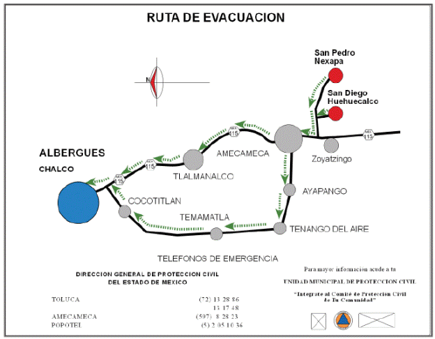
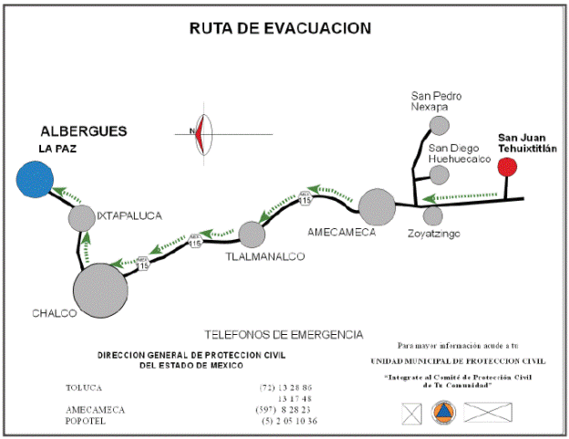
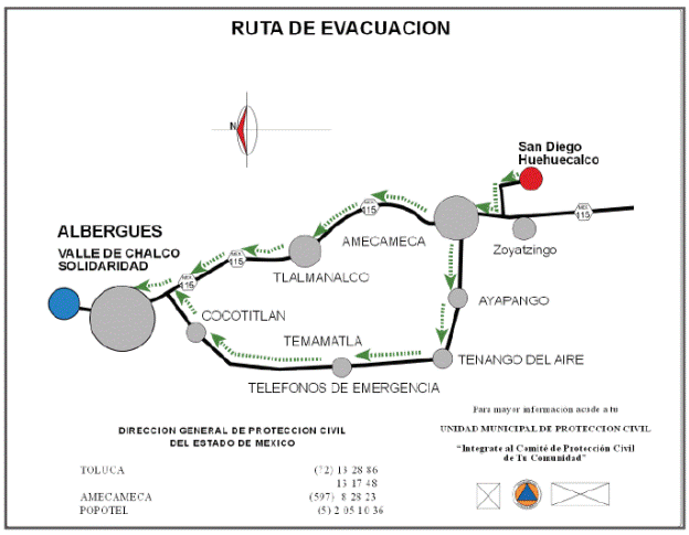
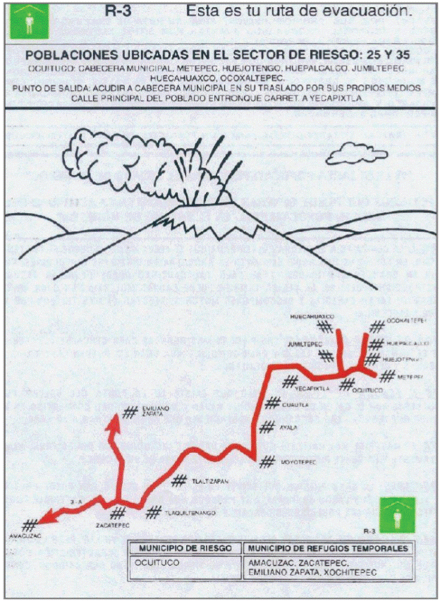
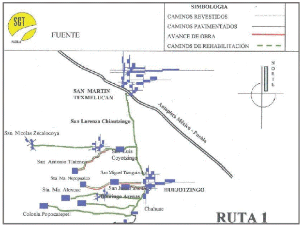
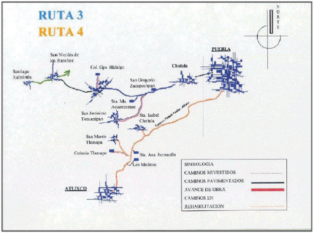
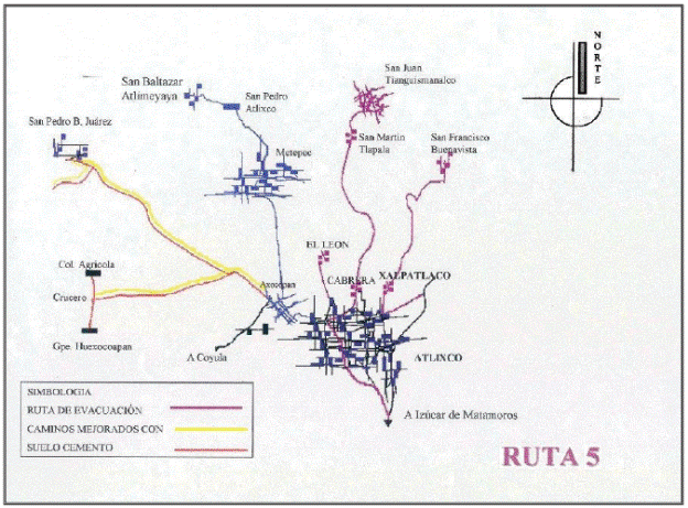
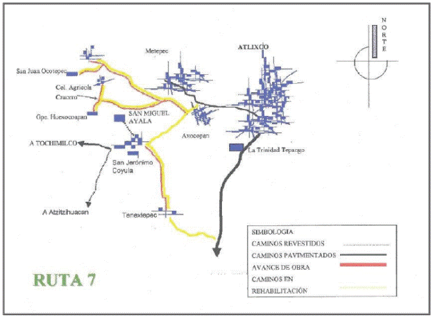
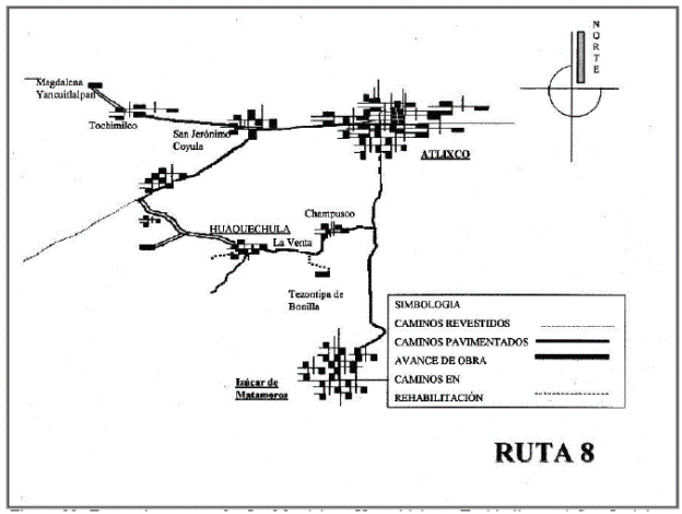
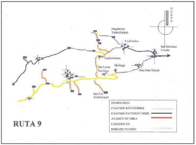
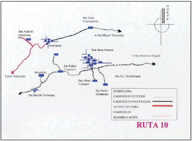
Evacuation routes around Popocatépetl Volcano were chosen after a comprehensive analysis of the existing roads and dirt tracks, to determine which were the most efficient and fastest access between the endangered towns and the sites of the temporary shelters designated by civil protection authorities of the states of Mexico, Morelos, and Puebla. Along each evacuation route, transit control points are included to prevent evacuation vehicles using a wrong route. In these control points state and municipal traffic officers should remain to ensure the secure flow during a contingency. To improve the capacity of the routes, some of them were paved or repaved, some bridges were expanded, and others constructed. Some dangerous curves were realigned, and some beltways roads were built to bypass towns and population centers, as was the case for the Atlautla-Popo Park beltway. In such manner this way, six routes for the western sector of the volcano, corresponding to State of México, were selected (Appendix 2, Figures 9 to 14). In the State of Morelos, evacuation routes for two villages with high risk were established in the southern sector of the volcano (Appendix 2, Figures 15 and 16), and for the State of Puebla on eastern side of volcano, ten evacuation routes were established (Appendix 2, Figures 17 to 25; the Figure 19 contents evacuation routes 3 and 4).
Distances and travel times between the meeting sites of high-risk villages
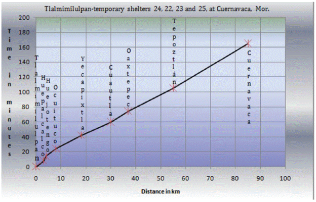
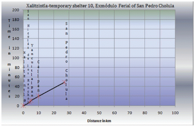
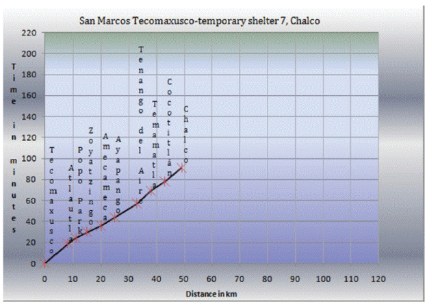
For decision-making to be effective during a volcanic crisis in an effective risk-management scheme, it is essential to know the travel times between key geographic points (Marrero et al., 2013). To measure the travel times between the settlements located in the high-risk areas and the temporary shelters, timed journeys at average speeds of 40 km/h with support of urban buses were performed along the evacuation routes marked in each of the state's operational plans (Mexico, Morelos and Puebla). With this information, time-distance tables and plots have been prepared to support evacuation decision-making and planning.
For the purpose of this paper, we present only four examples of high-risk settlements in the State of México (Appendix 3, Tables 7 to 10 and Figures 26 to 29), two in the State of Morelos (Appendix 3, Tables 11 and 12, and Figures 30 and 31), and four in the State of Puebla (Appendix 3, Tables 13 to 16, and Figures 32 to 35). The complete set of travel time data and plots may be consulted in Ramos (2018).
Meeting sites for the population in case of volcanic contingency
Civil-protection authorities of each state, together with municipality officials, jointly defined meeting points (or assembly or gathering places) for the population in case of contingency, as occurred in December 18 19, 2000. In most cases, such meeting points were set in the central parts of towns or at the municipal city halls, such as: near the Municipal Delegations at the State of México; near the Municipal Inspector and Auxiliary Presidencies at Puebla State; and near the Municipal Assistantships in the state of Morelos. In some cases, meeting sites were designated at other locales, such as: municipal and communal auditoriums; civic squares, near civil courts, chapels and shrines, elementary and secondary schools, sports fields, markets, at jagüeyes (small natural water dams), meeting rooms, roundabouts, squares, parks and gardens, in culture houses, trade unions and in offices of agricultural commissions.
Warning system and alerting devices
The general warning system used in Mexico is the Traffic Light Alert System TLAS (De la Cruz-Reyna 1995, 1996; De la Cruz-Reyna and Tilling, 2008; De la Cruz-Reyna et al., 2017). The colors universally used for Traffic lights indicate the level of warning and awareness of the population, and the phases within each of the three colors (green, yellow and red) indicate the level of response of the Civil Protection authorities. The way in which these levels are communicated to the population may vary between different towns. During a contingency, in the case when the population must move to assembly points or meeting sites different alerting devices activated by every local authority are used, and these can include special ringing of bells in churches, rockets, sirens and loudspeakers, whistles of some local companies, systems of particular sounds, paging with sound in private vehicles, sirens of ambulances, local broadcasting stations, and home announcements. Mass media such as radio and television stations, internet, newspapers, etc. are also widely used.
Discussion and conclusions
Decision-making during a volcanic crisis situation is a highly complex problem involving volcanological, social, economic, health, cultural, meteorological, and other factors. This complexity makes it very difficult to develop a general methodology for the management of risk, particularly during episodes of enhanced volcanic activity, because the nature and dimension of the response critically depends on the progression of the activity, and on the related spatial distribution of hazard and exposure. An optimal mitigation of risk requires a layout of information and criteria that provides the Civil Protection and other authorities of the factors needed for appropriate decision-making. The present work intends to provide a risk-management tool to assist the involved stakeholders in determining the appropriate and adequate level of response. This tool or layout -in the form of maps, tables, and data-that is described here builds on the experience of the risk management gained over more than 20 years of eruptive activity at Popocatépetl Volcano, including the response to some critical situations during which precautionary evacuations were necessary. The possibility of other scenarios corresponding to much larger eruptions, such as some that occurred in the geological record of Popocatépetl, are also considered indirectly.
Of particular importance is the use of the layout for the choice of evacuation routes, community-shelter links, and the determination of evacuation travel timings for different possible volcanic activity scenarios. Equally important, the layout can serve as a practical communication tool among the involved municipal, state and federal authorities, as it constitutes a single database for all levels of government. Given a potential red-level alert of the TLAS in a region determined by the consensus of the Advisory Scientific Committee, the layout will assist municipal, state and federal authorities to develop and undertake -in a short time- the optimal, mitigative actions to reduce potential risks for the population affected. However, in order to remain valid and useful, the information in the database must be updated as frequently as possible.