


 nova página do texto(beta)
 Inglês (pdf)
 Artigo em XML
 Referências do artigo
 Enviar este artigo por email
 Citado por SciELO
  Similares em
SciELO
Similares em
SciELO 
 Permalink
Introduction
Syria is located in a semiarid region, where most of the aquifer basinssuffer from water shortage and limitation in water supply. This situation cameas a result of the climatic conditions prevailing in the region, increasing in population rateand accelerated urbanization and economic development. Those combined factor surged during the last three decades the decision-makersto plan for construction tens of damsto meet the increasing demands for water. Syria has actually more than 160 earth fill dams and impounding reservoirs scattered throughout all the Syrian territory. Several of those damsas the earthen dams around the world unfortunately suffer from common filtration or leakage problems.
Water leakage in dam almost occurs either through the bedrock of dam’slake or through the dam body foundations. The geological and tectonic features such as faults, fractures and karstic featuresare the main factors of the leakage causes in earthen dams (Al Saigh et al. 1994; Johansson and Dahlin, 1996; Panthulu et al., 2001; Wan and Fell, 2004; Rozycki et al., 2006; Oh and Sun, 2008; Asfahani et al., 2010; Boleve et al., 2011; Bedrosian et al., 2012).
Modern geophysical techniques in this context are considered as an effective tool in dam’swater leakage investigations. Recently, Electrical Resistivity Tomography (ERT) becomes one of the main geophysical techniques wildly employed in hydrogeology and earth sciences applications. This technique has proven its performance in detecting the leakage path way soccurring in earthendams through numerous works around the world. (Seaton and Burbey, 2002; Sjödahl et al., 2006; Cho and Yeom, 2007; Osazuwa1 and Chii, 2009; Zhu et al.,2011; Al-Fares 2011; Thompson at al., 2012; Ikard et al., 2014). The present paper is therefore oriented towards demonstrating on how the modern geophysical methods such as the ERT one widely contributes in solving hydrogeological problems basically related to dame leakages. Abu Baara dam in Syria is treated herein as a case study, where an integrated geophysical approach, including different techniques with their specific interpretations is proposed and applied. This approach could be easily practiced in other dams suffering from similar leakage’s problems.
The main objectives of this paper are therefore the following:
Proposing an integrated geophysical approach for delineating and solving the dam’s leakage problems.
Carrying out geophysical surveys in Abu Baara dam, including mainly the ERT and traditional VES sounding techniques.
Interpreting the acquired geophysical results by different interpretative techniques, such as the 2D inversion of ERT, practiced on three executed profiles (P1, P2, and P3), Inverse slope method, and Pichgin technique, practiced only on P1.
Identifying the potentialleakage zones within the substructure bedrock close to this dam, through integrating and compiling the different geophysical results obtained in this research case study.
Geological and Hydrogeological Framework
Abu Baara dam is situated at the southern margins of Al-Ghab plain depression, 30 km west of Hama city (Figure 1). The depression of Al-Ghabis developed by the effect of the tectonic evolution along the northern parts of the Dead Sea Fault System (DSFS) in the northwestern part of Syria. This depression forms a plain region suitablefor agriculture due to the suitable climate conditions, fertile lands and reasonable average rainfall (700 mm/y). The flanks of the depression are clearly limited by faults with series of blocks and scarps (Devyatkin et al., 1997; Brew, 2001; Gomez et al., 2006; Hamade and Tabet, 2013).
Geologically, Al-Ghab depression is filled with Neogene and Quaternary lacustrine, and alluvium deposits. The thickness of these deposits may reaches more than 100 m in the central part of the basin. The Neogene and Quaternary sediments are uncomfortably over laying the Cretaceous calcareous rocks, which form the bottom of the basin (Ponikarov, 1963). The lake of Abu Baara dam is mainly composed of Quaternary alluvial deposits of clays, silts, sands and gravels (Q3), in addition to some conglomerates of carbonate-siliceous cement (Figure 1). The thicknesses of the Quaternary deposits vary from 1-10m in some places. The limestone and dolomite rocks of Cenomanian-Turonian (Cr2cm-t) constitute the bedrock of the dam’s lake. Those rocks are characterized by extensive fissures and karstic features, which contribute in forming of cavities and karstic conduits (Ponikarov, 1963).
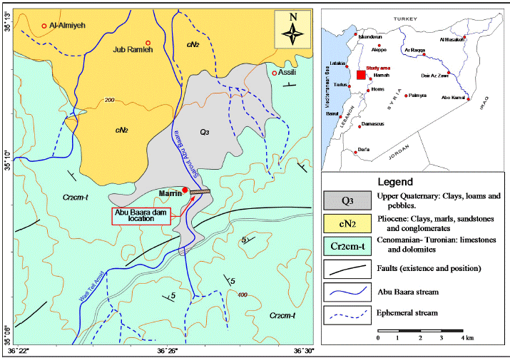
Figure 1 Simplified geological map of the study area showing the location of AbuBaara earth dam (modifiedafter Ponikarov, 1963).
Hydrogeologicaly, the limestone and dolomite of Cenomanian-Turonian rocks constitute the main aquifer in the study area. These formations are characterized by high permeability due to the presence of faults, fractures as well as the common occurrences of karstification at various depths. Whereas, the Quaternary alluvial deposits, composed of clay, sand and gravel constitute the second groundwater aquifer in the study area. The groundwater flow direction is generally from south to north corresponding to the rivers flow direction in the region. These aquifers receive its groundwater feeding from direct recharge of rainfall and drainage network.
Abu Baaradam characterization
Abu Baara dam is one of the earthen-filled dams in Syria, which suffers from an intensive leakage through the lake’s bedrock. The dam is located close to Maarin village at the southern margins of Al-Ghab plain, north-west of Syria (Figure 1). The dam was built in the eighties of the last century to protect a part of Al-Ghab plain from rain floods and to satisfy the needs of irrigation and agricultural development in the area. The dam’sembankment is essentially composed of a homogenous clayey core surrounded by filtering layers of sands and various mixtures on sides (Figure 2). The filtering layers themselves are covered by support coarse rock fills to protect the clay core and save the stability of the dam. The dam’s embankmenthas east-west direction, perpendicular to the main valley, and extends at distance of 720m with maximum thickness of 24.5m. The crest of the dam has as an absolute elevation of 234.5m above sea level (a.s.l). The dam’s lake extends on a surface of 100 hectares with a storage capacity of 7.6 million m3. The dam is subjected to an intensive leakage, despiteits modest water storage capacity. However, it represents a useful scientific case study. In fact, the dam is located in a complicated geological area and the site location contains many tectonic and karstic features, which are considered as the main causes of leakage problems. Abu Baara dam set in operation in winter 1988, where it filled up with water for the first time. An intensive leakage was appeared through the filling of the dam such as the water were flowing from some boreholes drilled behind the dam body, and the water level in the lake was severely decreasing. This phenomenon has been repeated in several subsequent seasons in particularly at certain storage levels in the lake. Afterward, the Directorate of Land Reclamation implemented some geoelectrical surveys (VES) in the lake and on the right bank of the dam. Al-Diab (2008) carried out a horizontal profiling and SP surveys behind the dam body and on the banks of the lake. The results of those surveys clearly showed the presence of an intersection of two faults close to the main axis of the dam and some SP anomalies in certain locations around the dam. Nevertheless, the faulted area has sealed by a clayey layer of several meters thick, but the leakage processes still increasing and ongoing especially at high water levels. This may posea threat to the stability and safety of the damin the future.
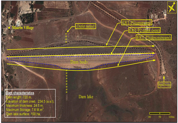
Figure 2 Locations of the ERT profiles carried out in Abu Baara earthen dam (Google Earth). A geophysical survey using electrical resistivity tomography ERT and traditional VES soundings were therefore proposed in order to characterize in detail the substructure bedrock close and beneath the Abu Baara dam body. Such a survey helps in delineating the probable zones of leakage paths through carrying out a number of ERT profiles in up and downstream sides as well as on dam crest.
Methodology and Materials
2D Electrical Resistivity Tomography (ERT)
Traditionally, the direct-current (DC) electrical survey is used to determine the subsurface resistivity distribution by measuring the electrical potential difference between a pair of potential electrodes M and N, as shown in Figure 3. on the ground surface with a current applied through a pair of current electrodes A and B. The apparent resistivity ρa in Ohm.m (Ω.m) is then computed from Ohm’s law:
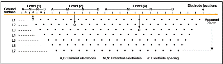
Figure 3 Electrical resistivity tomography configuration. Increasing the distances between current electrodes implies a deep penetration depth.
Where k is a geometric constant that depends only on the reciprocal positions of the current and potential electrodes; Δv is the measured potential difference in mV; and I is the applied electric current in mA.
Recent developments in DC technology allow automatic measurements, by switching the current and potential electrodes between a series of equally spaced electrodes laid out along a profile (Figure 3). This allows a dense sampling of subsurface resistivity variation at shallow depth within a short amount of time.
Multi-electrode resistivity survey is a combinational technique of profiling and sounding involving a number of electrodes with a fixed inter-electrode spacing. With the multi-electrode survey one can get lateral as well as the vertical information of the shallow subsurface. The measured apparent resistivity is converted into true resistivity using inversion software in order to produce the 2D resistivity cross-section image (Tomogram). The output from the inversion software displays the inverse model resistivity section, which could be thereafter treated geologically point of view.
An electrical resistivity tomography survey (ERT) was carried out in Abu Baara dam site to obtain a comprehensible image of the geological substructure close and beneath the dam body. The resistivity-meter Syscal Switch-72 was used to acquire the field ERT measurements. The instrument is modern and equipped with control unit and four multi-swatches cable bobbins to connect 72 electrodes at once with maximum inter-electrodes spacing of 5m. Seventy-two electrodes were instilled in a straight line at the selected profile in the study area according to the selected inter-electrodes step. The measurement operation is performed depending on a basis of special mathematical sequence prepared in advance using special software, where the configuration and the interval between the electrodes are selected. The main sequence has maximum length of 360m with an electrode spacing of 5m. In the case where the measuring profile is longer than the main sequence (more than 360m), it is necessary to use a Roll-Along Sequence, compatible with the standard sequence in term of configuration and the inter-electrodes spacing, to end the profile.
The Wenner-Schlumberger array has been purposely applied in the present project work. The advantages of such a configuration over other geoelectrical arrays, such as dipole-dipole or Wenner or Schlumberger,are its reliable stability and itsability to detect horizontal and vertical subsurface features. Moreover, the use of Wenner-Schlumberger configuration provides a good signal/noise ratio for the measurements, and permits getting full density of data from different levels of depth. (Dahlin and Zhou, 2004; Candansayar, 2008). According to the configuration applied in this work with 72 implemented electrodes, the sequence of measurements includes therefore 759 measured points, distributed on 16 depth levels. In addition, 304 points are added for each applied roll-along sequence. The collected data are automatically stored in the instrument’s memory to be available later for quantitative treatment and interpretation.
ThreeERT profiles of 715m length for each one were executed in Abu Baara dam site (Figure 2): the first one was in upstream side (behind the dam body), the second at the top of the dam’s crest and the third in downstream side. These profiles are straight and parallel to the dam body. It is worth mentioning that the field measurements of the ERT profiles were carried out through the summer season where the dam’slake was dry and completely empty of water. Additionally, a topographical survey was also carried out for each profile using a GPS devise with UTM projection.
Inverse Slope Method (ISM)
This method is widely practiced for the estimation of various parameter layers in 1D resistivity surveys (Narayan and Ramanujachary, 1967). Using the ISM, the field Schlumberger data are plotted on a simple linear graph paper for generating of a straight line segment by joining various points. The values of the inverse resistance (AB/2ρa) are plotted against the electrode separation AB/2. Each line segment represents a distinguished layer and the intersections of the line segments with the multiplication of a factor of 2/3 correspond to the depths to the particular layers. This method allows the real thicknesses and resistivities of the corresponding layers to be obtained. It is recently applied in Syria for solving different complicated geological problems, and proven high performance in comparing with traditional curve matching technique, (Asfahani, 2016). It is applied in this research for interpreting the nine VES data acquired along profile P1. The maximum electrode current AB used for those VES is of 300 m order, allowing a maximum depth penetration of 50 m approximately to be obtained.
Pichgin and Habibullaev Technique
Pichgin and Habibullaev technique is oriented towards interpreting vertical electrical soundings (VES) carried out along a given profile (Pichgin and Habibullaev, 1985). It is the most sophisticated one for delineating the subsurface structural features (Asfahani, 2007; Asfahani, 2011).
The theory behind the Pichgin-Habibullaev technique can be summarized as follows: Suppose two vertical electrical soundings, VES1 and VES2 are performed on either side of a vertical contact. For every given current electrode half-spacing (AB/2), all the resistivity profile curves will be intersected at a point located directly over this vertical contact. The locations of the vertical electrical soundings carried out on a given profile are there for eplotted on the abscissa, and the corresponding measured apparent resistivities for each given AB/2 are plotted on the ordinate, as shown in Figure 4.
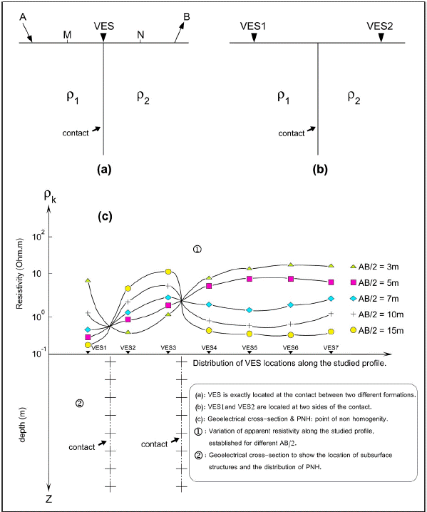
The intersection points of the resistivity curves, which are termed Non-Homogeneity Points (NHP), are plotted on a 2-D (x,z) geological section. The depth (z) of each NHP can be determined from to the following equation:
where (AB/2)i and (AB/2)j are the half-spacings between the electrodes A and B, at which two horizontal resistivity curves are intersected. The sub fractured zones are determined according to the distribution and interpretation of NHP along the studied profile.
According to this technique, geological interpretation of the NHP is based on the following assumptions:
When the NHP are distributed as oblique lines located at shallow depths, they indicate the presence of an inhomogeneous lithologic contact.
If they are arranged along oblique lines dipping at an angle exceeding 30° at depth, then they represent a fractured zone.
If they are scattered randomly near the surface, then they indicate an homogeneous lithology.
If they are arranged in regular forms, then they may reflect certain geological structures, such as synclines, anticlines, or horizontally layered strata.
Those above assumptions have been verified and calibrated through several field examples in Syria, where this technique has proven high performance in solving different field mining, geological and hydrogeological problems (Asfahani and Mohamad, 2002; Asfahani and Radwan, 2007; Asfahani et al., 2010). This technique is applied in this paper to interpret the nine VES data acquired along profile P1 in order to extract as maximum as we can the main anomalous structural features, that could be related to the potential leakage zones in the studied Abu Baara dam.
Results and discussion
The collected ERT field raw data obtained along three profiles P1, P2, and P3were invertedusing RES2DINV inversion software (Loke and Barker, 1996), to characterize the bedrockof the dam’s lake substructure. The investigation depth of the ERT configuration applied in this research is of 50 m approximately. The least-squares method including smoothing of model resistivity was used to invert the collected data. The optimization of this method is based on reducing the difference between the measured and calculated apparent resistivity values, where this difference is expressed by Root Mean Squared (RMS) error. The RMS errors in our case study for the inversed geoelectrical sections are ranged between 7 and 12% for 4 and 5 iterations. Increasing the number of iterations for improving RMS errors does not necessarily give reliable and good interpretation geologically point of view.
The inverted model resistivity section represents the true subsurface resistivity values of the investigated geological formations. The ERT profiles were interpreted depending on the available geological information of the study area.
ERT-P1 Profile
The ERT-P1 profile was carried out in upstream side at a distance of 10m from the dam body (Figure 2). The profile starts from the western edge of the embankment to end up at the eastern edge traversing a distance of 715m. Figure 5. shows the inverted ERT-P1 geoelectrical section, which can be divided into three principal distinguished blocks:
The first block runs from the beginning of the ERT-P1section to the distance of 280m. This block includes a subsurface layer, of 10m thickness in average, which corresponds to the Quaternary alluvial deposits (Q3), composed of loams, sands and gravels. The electrical resistivity values of these formations are ranging between 50 and 200Ωm. The alluvial deposits overlay a layer of hard limestone and dolomite Cenomanian-Touronian (Cr2cm-t) rocks. Those rocks are characterized by an irregular feature due to fractures and cracks, which makes them heterogeneous chromatically in the geoelectrical section. The limestone and dolomite rocks have resistivity values of more than 1100Ω.m. These rocks constitute the main hard bedrocks of the dam lake. Otherwise, a distinctive resistive anomaly was noticed between the distance interval60 and 80m of the ERT-P1 section (Figure 5). This anomaly is distinguished by a high electrical resistivity value (up 1200Ωm), which most likely could be associated with probable karstic cavity developed within the limestones bedrock. Evidently, the presence of a possible cavity constitutes a suitable potential pathway for water leakage occurrence, especially when the water storage reaches high levels in the lake.
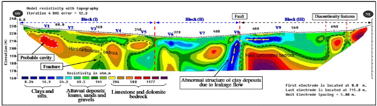
Figure 5 Inverted geoelectrical section of the ERT-P1 profile carried out behind the dambody (upstream site), V: locations of VES.
The second block extends within the distance between 280and 440m of the ERT-P1 section. This zone seems well matched with the course of the main valley behind the dam body. The alluvial deposits are prevailing in this part of profile and filling the valley with exception the existence of two big scattered masses of limestones. The right boundary of this block (at the point 440m) is determined by a vertical hard rocks edge. This almost could be related to the occurrence of a tectonic event such as a fault struck the main valley. Moreover, adistinct anomaly of clay was identified adjacent to the mentioned vertical edge; this abnormal structure may due to a vertical groundwater flow towards the deeper formations. This finding may indicate to the existence of hydraulic connection between the shallow and the deep geologic formation. It is obvious that significant leakage most likely occurs through this sector along the tectonic contact zone between the alluvium and the limestones rocks.
The third block extends from the point of 440m to the end of the geoelectrical section (Figure 5). The alluvial deposits thickness ranges between 10 to 20m, with resistivity values reach 150Ωm. Those deposits overlay the resistive hard limestones bedrock (more than 1100Ωm). A discontinuity features were observed in two locations at the end of the profile (at 630 and 670m), these features are corresponding to fractures in the limestones and dolomites rocks. These discontinuities in the bedrock form additional possible pathways for water leakage from the dam’s lake.
Inverse slope method ISM with adapting 1D assumption has been applied in this research for interpreting the nine Schlumberger VES distributed along P1 as shown in Figure 6. True thicknesses and resistivities for the corresponding layers under the study profile P1 have been obtained as shown in Table 1. The most important remark observed while interpreting those nine VES is the presence of negative slopes, indicating high resistivity values in the studied P1 section. Those high values clearly reflect the hard limestone and dolomite rocks existed in the study region (Ponikarov, 1963). The advantages of applying ISM is that it easily distinguishes between the different layers under the study VES. The low resistivity values are attributed to the Quaternary alluvial deposits, while the high ones are attributed to the Cretaceous hard limestone and dolomitic rocks. The ISM results obtained confirm well those obtained by the ERT measurements and discussed above, particularly the low and high resistivity distributions.
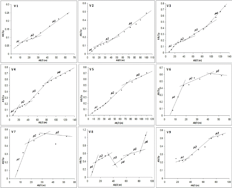
Figure 6 Quantitative 1D interpretation results of nine VES measurements carried out along ERT-P1 profile obtained by ISM.
Table 1 ISM Interpretation results of the nine VES distributed along P1.
| VES | Layer resistivity values (Ω.m) | Layer thicknesses (m) | |||||||||
| ρ1 | ρ2 | ρ3 | ρ4 | ρ5 | ρ6 | h1 | h2 | h3 | h4 | h5 | |
| V1 | 236 | 385 | 227 | - | - | - | 8 | 10 | - | - | - |
| V2 | 161 | 284 | 333 | - | - | - | 12 | 20 | -- | -- | -- |
| V3 | 146 | 435 | 240 | 120 | - | - | 13 | 9 | 28 | -- | -- |
| V4 | 106 | 440 | 187 | 286 | - | - | 10 | 10 | 29 | -- | -- |
| V5 | 167 | 117 | 234 | - | - | - | 24 | 24 | -- | -- | -- |
| V6 | 27 | 167 | ∞ | - | - | - | 11 | 17 | -- | -- | -- |
| V7 | 29 | 436 | ∞ | - | - | - | 12 | 10 | -- | -- | -- |
| V8 | 20 | 123 | ∞* | 72 | 169 | 19 | 8 | 12 | 7 | 11 | 16 |
| V9 | 714 | 209 | 181 | - | - | - | 22 | 26 | -- | -- | -- |
* Very high resistive layer
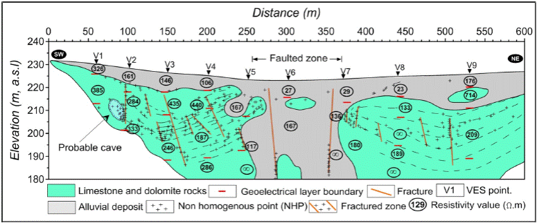
The same nine VES distributed along profile P1 have been interpreted by Pichgin and Habibullaev technique explained above. The geometry distribution of the Non Homogeneous Points (NHP) in the 2D (X-Z) section shown in Figure 7 clearly indicates the presence of three main blocks. The central one of more than 150 m wide could be related to a faulted zone, representing the main alluvial valley. The two other right and left blocks are related to the Cenomanian-Turonian limestone and dolomitic rocks. At a detailed level, the NHP clearly showa basinal structure, and the positions of the fractured zones in those two blocks. Their locations are the main leakage points in the study dam under profile P1. It is worth mentioning that the results obtained by interpreting VES data using Pichginand Habibullaev technique confirm well those obtained by ERT measurements along Profile P1.
ERT-P2 Profile
This profile was implemented along the dam’screstin parallel with the previous ERT profile (Figure 2). This ERT profile, located on the top of dam body, has been carried out by using an electrical driller to dig holes, 4m apart, in the hard asphaltic layer to facilitate the electrodes plantation. The planted electrodes were wetted with salty water and some clay added to ensure a good contact with the underlying soil and to reduce the noise. This profile has length of 716m and 234.5m above sea level (a.s.l) as a constant topographic elevation. Figure 8 shows the inverted geoelectrical section of the ERT-P2 profile, where two main zones can be vertically distinguished; the first zone is directly related to the clayey core of the dam body, marked by clear blue color in Figure 4. The white dotted line represents the lower boundaries of the dam body with the original land surface of the lake. The resistivity values of this zone range between 20 and 50 Ωm and the thickness increase towards the main valley to reach 25m.The clayey core of the dam seems to be intact and structurally homogeneous and the lower boundaries are clear and distinct especially at the contact with the underlying bedrocks. The second zone of the ERT-P2 section represents the hard limest ones and dolomites bedrock. The general structural of this zone is similar to the ERT-P1 structure. It is consisting of two units of massive carbonates rocks separated by the main valley: the first unitext ends from the beginning of the geoelectrical section until the point 320, while the second starts from the point 512 to the end of the section. Both units are well differentiated and characterized by high resistivity values.
The central part of the second zone extends along the distance between 320 and 512m, this part corresponds to the main valley course underneath the dam body. It is believed that the absence of hard bedrock at this part of section could be attributed to dissolution processes of the carbonates rocks by the influence of the water flowing stream, or probably related to tectonic activities such as faults leading to the formation of a subsidence faulted structure filled up later by alluvial deposits (Figure 8). The absence of the bedrock under the central part of the dam body could pose problems in future related to the safety and stability of the dam, particularly when the water reaches high levels during the rainy seasons. Manycracks covering the top of the dam were observed during the field workin the asphaltic layer. This seems to be a negative indicator and must be taken into consideration through the implementation of a permanent monitoring program in order to prevent probable failure of the dam. It is consequently believed that most of the vertical leakage occur sthrough this sector at the contact between alluvial deposits and the hard limestones rocks.

ERT-P3 Profile
The ERT-P3 is implemented in the downstream side adjacent to the dam body (Figure 2). This profile extends as the other profile along 715m of length with inter-electrode spacing of 5m. A topographic survey was performed for the natural ground surface of the lake along the profile Figure 9 shows the interpretation of the geoelectrical ERT-P3 section, which seems to be structurally similar to theERT-P1 section. It can be therefore also divided into three main blocks differentiated horizontally:
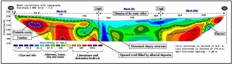
Figure 9 Inverted geoelectrical section of the ERT-P3 profile carried out on downstream site of the dambody.
The first and third blocks are interpreted together because they are composed of the same formations. The first block extends from the beginning of the section to a distance of 300m, while the second one starts from 500m to the end of ERT section. The two blocks include a surface layer of alluvial deposits (Q3). The thickness of these deposits ranges between 1 to 5m in the block(I), and reaches 20mat the third block, since it increases towards the main valley. The resistivity values of these deposits vary as mentioned above from 40 to 150Ωm.The alluvial layer covers the bedrock of the hard limest ones, which are characterized by high resistivity values (300-1200Ωm), as shownin geoelectrical section. The bedrocks are dipping about 7° (block I) and 15° (block II) towards the main valley. On the other hand, a resistive anomaly is observed between the interval 60 and 90m of the section, this anomaly has been also observed in the ERT-P1 section. It is characterized by a high electrical resistivity value (1200Ωm), which is most likely related as mentioned above to karstic cavity within the limestone bedrock. The appearance of this anomaly in the ERT-P1 and ERT-P3 sections at the same location probably indicates to the presence of a subsurface karstic conduit passing under the dam body at this sector. This subsurface conduit certainly constitutes a suitable pathway for the occurrence of intensive leakage from the lake to outside the dam, especially at the high water storage levels.
Another abnormal structure is also observed between the distances 215-280mof the ERT-P3 section. This structure seems as a void or an opened cavity filled with alluvial deposits (40-150Ωm). This void or cavity could be resulted by the influence of a tectonic activity followed by erosion and dissolution processes of the limestone and dolomite rocks by the act of water flow effect. Moreover, the discontinuity features identified at the ERT-P1 section is also present in ERT-P3 section at the same location, this features are almost correspond with a fracture extending perpendicular to the dam body within the subsurface carbonate bedrocks. This fracture expands with the depth, and it is filled with alluvial and clays deposits of low resistivity (Figure 9). Existences of those fractures constitutes an additional causative of the water leakage from the dam lake.
The second block is stretching along the distance from 300 to 500m, and forming the central part of ERT-P3 section. The margins of this sector are in concordance with the main valley and they are delineated by two vertical rockyedges. This part of the section is completely composed of alluvial deposits, where their thicknesses reach more than 50m. Moreover, an abnormal structure of clay, located between 300-320m, is observed at the left edge of this block. This structure represents additional evidence of the presence of a vertical water leakage between the surface and the deep formation. This block is structurally considered as the most significant part of the profile, where many structural anomalies are localized and identified. The filtration and the leakage processes are mostly occurring through this sector. The table (2) globalizes the resistivity values for the different subsurface detected structures obtained from the inversed ERT sections.
Table 2 globalizes the resistivity values of the different detected structures obtained from the inversed ERT sections.
| Detected features or structure | Resistivity values range (Ω.m) |
|---|---|
| Clays and silts | 5 - 20 |
| Alluvial deposits | 40 - 120 |
| Limestone and dolomites rocks | 400 - 1200 |
| Abnormal clayey structure | 5 - 10 |
| Dam embankment | 20 - 40 |
A global structural comparison between the geoelectrical ERT sections of the three profilesis illustrated in Figure 10. The general structure of these sections seems to be similarand they are composed of three distinct structural blocks. A remarkable faulted zone can be traced within the interval 300 to 500m of the ERT sections. This zone is compatible with the main valley. Moreover, a karstic cavity located at the beginning ofthe ERT sections can be observed as well as the presence of discontinuity features at the end of the sections. It is worth mentioning, that many field observations have been noted during the implementation of the field measurements, which point to the role of the tectonic activity and other karstic features in the leakage processes. Figure 11 shows some of theses features, where small sinkhole of more than 50 cm of diameter and a large fracture extended for more than 200m parallel to the dam lake marginare observed in many places throughout the lake and behind the dam body.
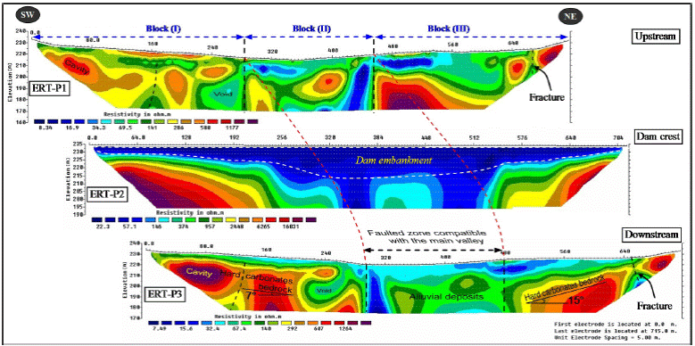
Figure 10 Comparison between the general structure of the inverted geoelectrical ERT profiles carried out in upstream, dam crest and downstream of Abu Baara dam body.

Figure 11 Locations of some leakage features observed at the right bank of Abu Baara dam lake, (a): one of the sinkholes which is located nearby the limestone and dolomite rocks boundary (more than 50cm of diameter), (b): a large fracture of 2-3 depth extends for more than 200m in parallel with the dam lake margin.
Conclusion
An integrated geophysical approach, including different ERT and VES techniques with their specific interpretations is proposed and applied in Abu Baara earthen dam in Northern Syria. The competence and the performance of this approach is proven through the treated case study for solving hydrogeological problems related to leakages of dams. The use of ERT as the main technique in this approach proved also its performance in outlining some critical subsurface geological features such as faults, fractures and cavities. The three inverted ERT sections P1, P2, and P3 discussed in this paper clearly showed three distinct structural blocks: The first and third blocks are consisting of surface alluvial layer composed of loams, sands and gravels covering a hard fractured limestone and dolomite bedrock. The second central block coincides with the course of Abu Baara stream and could be related to a faulted structure that completely filled by more than 50m of alluvial deposits. The presence of this thick structure is considered as one of the main responsible causes of the vertical leakage component occurring through the contact zone between the hard fractured carbonate rocks and the alluvial deposits in the dam lake. Additional geological, tectonic and karstic features such as fractures, faults and cavities have been identified within the underlain carbonates bedrock, which constitutes the major geological formations of dam’s lake floor. Those anomalous features localized and delineated by the inverted ERT and Pichginand Habibullaev techniques represent additional potential pathways of water leakage from the dam.
The absence of the hard bedrock underneath the dam body could be a source of risk to the safety and stability of the dam, where some cracks have been observed in the asphaltic layer covering the top of the dam embankment. A permanent monitoring program should be therefore maintained to provide the precaution before the failure of the dam especially during the heavy rain storms, which characterize the region and lead to a sudden increase in water levels in the dam. The proposed approach with its different geophysical techniques contributes efficacy in solving different subsurface hydrogeological problems, such as the one treated in this paper. It could be easily practiced in other similar dams suffering from leakage’s problems.

