


 nueva página del texto (beta)
 Inglés (pdf)
 Artículo en XML
 Referencias del artículo
 Enviar artículo por email
 Citado por SciELO
  Similares en
SciELO
Similares en
SciELO 
 Permalink
Introduction
Syria has suffered from several destructive earthquakes along the history, where the historical documents show many large earthquakes along the Dead Sea Fault System (DSFS). During the past decade, palaeoseismic investigations along the DSFS have proven successful in identifying surface ruptures associated with historical earthquakes (Gómez et al., 2003; Wechsler et al., 2014), and in documenting evidences for long-term earthquake behavior such as temporal clustering (Klinger et al., 2015; El-Isa et al., 2015). The focus in the present study corresponds to the recent instrumental seismic activity in Syria. The Syrian National Seismological Network (SNSN) has been installed in 1995 and covered the Syrian territories. Thanks to the SNSN, this work intends to be the first careful and detailed analysis of the recent instrumental seismicity of Syria, which has been recorded during the period from 1995 to 2012. The main purpose of this work is to characterize the seismicity pattern of Syria by locating earthquakes and calculating the focal mechanism of some strongest events, and then, relate the earthquake activity with the well-known tectonic structures in the region. This would improve and strengthen the knowledge of the actual seismotectonic deformations taking place now. Thereby, the instrumental seismic activity should be documented, and it is hoped to improve the seismic hazard assessment and the development of appropriate risk-mitigation strategies.
Seismotectonic setting
Syria is located on the northern part of the Arabian plate (Figure 1). It is bounded from the west by the northern section of the DSFS. Northeast of Antioch, the DSFS intersects the Eastern Anatolian Fault System (EAFS) and the Bitlis Suture zone, both of which comprise the northern border of the Arabian plate. At a gross scale, Syria can be spatially divided into four major ‘tectonic zones’ and intervening structural highs include the Palmyrides Fold Belt (PFB), the Abd-el-Aziz Faults, the Euphrates Fault System (EFS) and the DSFS (Figure 2). These major structural zones have accommodated most of the tectonic deformation in the country throughout the Phanerozoic, whereas the intervening stable areas remained structurally high and relatively undeformed (Barazangi et al., 1993; Brew et al., 2001). Additionally, the style of structural reactivation, in Syria, is dependent on the orientation of the aforesaid tectonic regions to the prevailing stress pattern. Furthermore, (Barazangi et al., 1993) inferred that the tectonism within the country is concentrated in those four major tectonic zones, which include a fold and thrust belt, a plate boundary transform fault, inverted basins and an extensive aborted rift. The DSFS is an extremely important tectonic feature, which accounts for the bulk of seismic activity in the eastern Mediterranean and accommodates the relative sinistral motion between the African and Arabian plates (Reilinger and McClusky, 2011). Recent GPS studies have characterized the first order geodetic velocity field around the DSFS (Alchalbi et al., 2010; Al-Tarazi et al., 2011; Saleh et al., 2012; Mahmoud et al., 2013; Masson et al., 2015). Focal mechanisms of moderate-to-large earthquakes show a sinistral motion along the DSFS (Salamon et al., 1996; Hofstetter et al., 2007). The state of stress is characterized by the coexistence of a normal faulting stress regime with the primarily strike-slip one (Palano et al., 2013). In a review of the slip and seismicity of the DSFS, Garfunkel (2011) concludes that the slip rate is slowing from an average rate of 6-7 mm/year over the last 5 Ma to 4-5.5 mm/year in the Pleistocene together with a slight eastward shift of the Euler pole of rotation between Sinai and Arabia. A quick review of the historical seismic activity in the eastern Mediterranean clearly demonstrates that this part of the world has been shaken since 2000 B.C. by strong earthquakes that destroyed thousands of structures, and caused severe casualties and loss of human life (Darawcheh et al., 2000; Khair et al., 2000; Guidoboni et al., 2004; Guidoboni & Comastri, 2005). The return periods of large earthquakes (M≥5) in Syria was estimated to be about 200-350 years (Ambraseys and Barazangi, 1989).
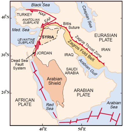
Figure 1 Map showing simplified tectonic setting of the Arabian plate and nearby tectonic features around Syria. Abbreviations: EAF: Eastern Anatolian Fault system, NAF: Northern Anatolian Fault system, Med: Mediterranean.

Data and Methods
In 1985 the General Establishment of Geology and Mineral Resources (GEGMR), responding to an initiative proposed by the Program for Assessment and Mitigation of Earthquake Risk in the Arab Region (PAMERAR), started the design and implementation phases for the construction of the SNSN. The network’s design objective was to monitor all discernible earthquake activity along the DSFS and its related branches in Syria and nearby Lebanon such as Serghaya fault. The 9 seismic stations of the southern sub-network became operational in late 1994 and early 1995 and allowed to record the micro-earthquake activity that occurred on November 22, 1995, along the Serghaya fault. The 11 stations of the northern sub-network followed the next year to complete the 20 stations of the western SNSN. The SNSN has been officially operated since January 14, 1995 (Dakkak et al., 2005). The 7 eastern stations were added in April 2002, where 2 of them were three-component seismic stations. In 2003, the SNSN consists of 27 short period (1 Hz) stations of ~50 km seismograph spacing (Figure 3). More information about the SNSN data, such as acquisition, transmitting, processing, recording, can be found in (Dakkak et al., 2005).

Figure 3 Map showing geographical distribution of the Syrian National Seismological Network (▲) and the principal faults. Fault geometry is summarized from Brew et al. (2001). Abbreviations: fault (F.), basin (B.).
The SNSN has provided the local instrumental data for the first time in Syria. During the study period 1995-2012, the SNSN has digitally recorded about 5000 local events. Hypocentral locations for the recorded local events were determined using a program based on HYPO71 algorithm (Lee, 1990), in which, the change in the arrival time due to change in hypocentral position is linearized. This program takes the station locations, crustal seismic velocity model, and the phase information in the input file. It assumes a trial origin time and hypocentral location for the earthquake, and improve the origin time and hypocentral location by iteratively minimizing the least square error of the travel time computed from the input station, crustal seismic velocity model and phase information. Because of the linearization of the problem several iteration steps are necessary to obtain the smallest misfit of observed and predicted travel-times, which is represented by the minimum average location root mean square error (RMS).
The hypocentral coordinates and the origin time are iteratively estimated using stepwise statistical regression procedure. That is an inversion process, which need many control parameters. Some of them have been fixed as the following: minimum number of stations to attempt a solution to be 4, minimum number of phases to be 3, cut-off RMS value to be 0.99 s, maximum number of iterations to be 99.
It is very common to express the overall location quality by the RMS as a value of the error parameters. Since seismic events are located with arrival times that contain observational errors and the travel times are calculated under the wrong assumption that the exact model is known, all hypocenter determinations will have errors. The RMS of the final solution is very often used as a criterion for ‘goodness of fit’. Although it can be an indication, RMS depends on the number of stations and does not in itself give any indication of errors. It is therefore not sufficient to give one number for the hypocenter error since it varies spatially in horizontal and vertical directions. The accuracy of events’ location is a critical factor for reliably identifying faulting parameters. To improve the accuracy of location, the records were filtered by using Butterworth order 3 filter, in order to get the best signal-noise ratio, where all P and S phases were manually picked. As a result, the number of arrival time readings was increased. Events were relocated with the new arrival times.
The magnitudes have been calculated from the coda wave duration via the formula (Bulletin of SNSN, 1995-2009):
where T is the coda duration (in sec) and D is the epicentral distance (in km).
A quantitative idea about magnitude and frequency of events could be obtained by adopting the empirical Gutenberg and Richter relation:
where N is the number of earthquakes of magnitude equal or greater than M, and a and b are constants for the region, where a is a measure of the level of seismic activity and b (b-value) is the rate at which events occur within a given magnitude range. Different methodologies for assessing the b-value of the Gutenberg and Richter relation are available in literature. The least-squares method (LSM) is often used, although not formally suitable since magnitude is not error free, cumulative event counts are not independent, and the error distribution of the number of earthquake occurrences does not follow a Gaussian distribution. The maximum likelihood method (MLM) has been widely applied to assess the b-value. In this study, the Gutenberg and Richter relation is evaluated from the available recorded events by the LSM and MLM methods using the code “bvalue.exe” from the SEISAN 10.3, software (2015).
The low seismicity in Syria and the insufficient coverage of seismic stations of SNSN (Dakkak et al., 2005) limit the number of fault plane solutions that can be obtained from the available records. The greater the magnitude, the better the seismogram trace and the higher number of seismic stations registering the event, are allowing an improved location and a more reliable focal mechanism determination. However, small events often exhibit a large scatter due to local structure and stress perturbations and are poorly representative of the regional stress field. Therefore, a probabilistic method, proposed by Zollo & Bernard (1991), was applied to calculate the focal mechanisms of some largest events. This non-linear inversion method assumes a double-couple point-source model, a well determined earthquake location, and the model parameters to be the fault angle orientations: strike, dip and slip (or rake). The posterior probability of these parameters for the given observational data set, P-wave polarities, is computed by using Bayesian approach. The method is based on the estimation, by an exhaustive search of the posterior probability, of model parameters. The maximum likelihood solutions are only represented by its lower hemisphere projection. The available data and the reliability of the solutions are carefully examined in order to get the best results.
Detailed analysis of results
The availability of recent instrumental data, allows the knowledge about the seismotectonic of Syria to be improved. For this instance, the spatial analysis is an important key, where a spatial comparison between seismicity and mapped fault locations allows to assess the possible activity along a given fault or group of faults. The hypocentral locations for the recorded events have been determined with a location uncertainty of less than 10 km (Figure 4). Thus, the epicentral map (Figure 5) can be considered reliable for the following interpretation of the present work. According to the epicentral map, the recent instrumental seismicity inside Syria is characterized by many clusters of weak events (M<4). Most of the recorded events are low magnitude and can be qualified as weak, where their average magnitude is approximately 2.0 (Figure 6). The focal mechanism of some strongest events (Figure 7) could be helpful to relate the earthquake activity with the well-known tectonic structures in the region. A detailed analysis on the recent instrumental seismicity, carried out in the present paper, allows observing some seismic types as follows: Swarm-type, Cluster-type, Occasional-type. This classification could help to present in detail the properties of seismic activity and its relationship with the tectonic features of some specific areas, and to focus on the most important fault zones.


Figure 5 Earthquake activity in Syria and nearby countries recorded by Syrian National Seismological Network from 1995 to 2012.
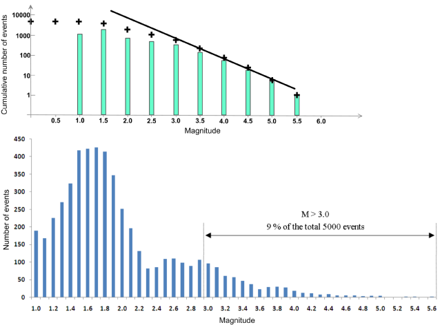
Figure 6 Frequency-magnitude distribution of the recorded events during the period of 1995-2012 in cumulative and non-cumulative plots.
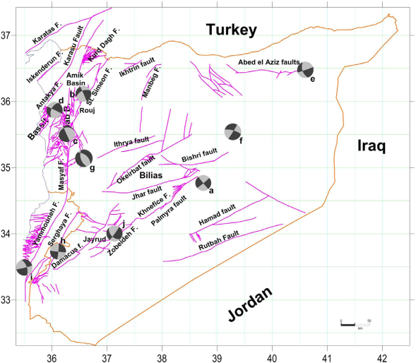
Figure 7 The focal mechanisms map of some largest events: a) an earthquake of Palmyra which happened on December 24, 1996 Mc=5.6, b) an event from the Rouj basin on May 20, 2003 Mc=4.0, c) an event from the Ghab basin on January 3, 1997, Mc=3.5, d) an event from Latakia-Killis faults system on July 19, 1996 Mc=3.9, e) an event from Abd-el-Aziz uplift faults on January 11. 1996 Mc=3.5, f) an earthquake of Bishri fault on December 18, 1994 Mc=5.0, g) the composite focal mechanism of the detected multiplet in Asharneh Plain, h) the composite focal mechanism of the biggest multiplet detected in Serghaya swarm on November 22. 1995, i) an earthquake of Roum fault on March 26, 1997, Mc=4.9, j) the composite focal mechanism of the detected doublet in Zobeideh fault. Mc: coda magnitude.
1- Swarm-type seismic activity
Earthquake swarms are generally observed in volcanic regions, and defined as prolonged series of earthquakes of small to moderate magnitude without a distinct major event and strike in a relatively short period of time. The seismicity of the Jordan Dead Sea Transform region is characterized by a relatively high proportion of seismic sequences and swarms, some of which are related to subsurface volcanic activities (El-Isa, 2012; Salamon, 2009). About 57 % of historical seismicity along the DSFS occurred in the form of sequences and swarms that lasted for variable periods of time, ranging from a few hours to a few days, weeks, months, and a few years (El-Isa et al., 2015). Relying on the instrumental seismicity of the Gulf of Aqaba region, El-Isa (2012) deduced that not less than 98 % of the local seismicity occurred in form of sequences and swarms. Swarms are often characterized by multiple or double earthquakes with very similar waveforms. The multiples or doublets have been interpreted as repeated slip on fault asperities or clusters of asperities. It offers the opportunity to re-examine the relationship between pre-existing fault zones and current seismicity in order to improve thereafter our understanding of the intracratonic seismicity patterns (Uski et al., 2006). Many swarms were observed in the recent instrumental seismicity in Syria, where the correlation between the observed swarms and the nearby faults was interpreted and analyzed through the spatial distributions of the hypocenters, as follows:
a- Serghaya fault
The NE-SW striking Serghaya fault branches out from the main transform of DSFS. It is a prominent structure located approximately along the Syrian-Lebanese border. Combined field investigations in geomorphology and paleoseismology have detected young fault scarps, mole tracks, pressure ridges and offset streams along the fault trace, which attest to recent coseismic ruptures (Nemer et al., 2008). The results of trenching (Gómez et al., 2001; 2003) demonstrated that the Serghaya fault has important implications in terms of regional tectonics and earthquake hazard. Serghaya fault was generally regarded, until 1995, as inactive since the Pliocene (Walley, 1988; Girdler, 1990; Butler et al., 1997). Asfahani and Abdul-wahed (2012) established an instrumental earthquake catalogue for the Serghaya fault for the period extending from 1995 till 2009, in order to characterize and evaluate its seismic hazard and behavior. They found that the earthquake activity of this fault produces little number of low magnitude events, at least during the study period. On November 22, 1995, a swarm of events was observed along the Serghaya fault (Figure 8). Mohamad et al. (2000) reported that this swarm was immediately triggered following the 1995 Aqaba earthquake at a distance of about 500 km. A total of 21 events occurred as swarms during the first three and half hours following the mainshock of Aqaba, where the strongest one was of magnitude MS=3.7. The Serghaya swarm is the first instrumentally swarm recorded by SNSN. The similarity of waveforms between the swarm events was examined, where a multiplet of 9 earthquakes and 3 of double earthquakes were found (Abdul-Wahed et al., 2006; Abdul-Wahed, 2007; Abdul-Wahed et al., 2011). The composite focal mechanism of the biggest multiplet (Fig. 7) demonstrates a good agreement between the fault plane solutions with NE Serghaya sinistral fault motion.

b- Southwest of Palmyrides fold-thrust belt
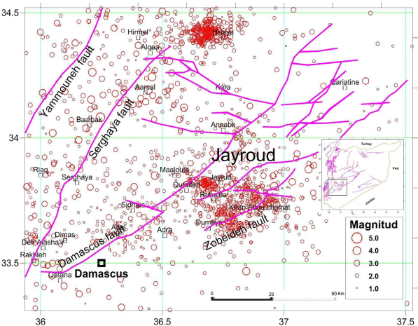
The Palmyrides fold-thrust belt, a NE-SW-trending ~400 km long and 100 km wide, is divided into southwestern and northeastern regions separated by Jhar fault (Figure 2). In the southwest of Palmyrides fold-thrust belt, 3 swarms of events were observed in 2004 in the west of Jayrud city (Figure 8). The first swarm occurred on February 8, 2004, including 6 events. The second occurred in the same site on May 16 and 17, 2004, including 22 events. In spite of the small size of the events (Mc=2.6-3.3), this swarm was widely felt at Ma’alula city and its surroundings. The third swarm of 8 events occurred on June 7, 2004, in which, an event attend the magnitude of 3.9. Another swarm of 8 events was observed on April 21, 2011, in Jayrud region. Those swarms can be related to southwest of Palmyrides faults as an extension of Damascus NE fault.
c- Baer-Bassit region faults
The Baer-Bassit region is located in a critical region near the boundary of the African and the Eurasian plates and the interaction between DSFS and EAFS. A Latakia-Killis faults system (Figure 2) was mapped as a thrust fault bordering the Baer-Bassit massif to the northeast, parallel to EAFS, where unusually steep dips were noted. This system was seen as connecting Latakia city area to the town of Killis in southern Turkey and the Kurd Dagh region, ~150 km to the northeast. The Baer-Bassit region is seismically considered as the most active in Syria (Figure 5) with high density of faults extending in the sea toward the southwest according the Cyprus arc. A swarm of 4 events started on June 3, 1996, in the sea against the Baer-Bassit region, where the biggest one has a magnitude of 4.5 and was felt in the whole costal region (Sbeinati and Darawcheh, 1997). Three swarms have been observed around Kassab city. The first of 5 events occurred on June 19, 1996. The second swarm of 6 events occurred on January 3, 2003, in which, an event had magnitude of 4.1. The third swarm of 3 events occurred on February 1, 2007. These swarms have been probably generated on Latakia-Killis faults system.
d- Kurd-Dagh region faults
The Kurd-Dagh region is located in the northwest of Aleppo plateau (Figure 2). This region is seismically active with high density of faults extending toward the northeast according to Latakia-Killis faults system. A swarm of 5 events started on March 23, 2010, in the southwest of Rajo city, and a swarm of 3 events occurred on September 21, 2011, in the south of Afrin city. Another swarm of 4 events occurred on November 20, 2011, in the south of Azaz city. Although the events of those swarms are of low magnitude, however, they indicate the activity of Kurd-Dagh region.
e- Roum fault
Fresh fault scarps and pressure ridges visible along the Roum fault trace attest to recent coseismic ruptures (Nemer and Meghraoui, 2006). On this fault, branching out from the DSFS in south Lebanon at the southern deflection point of the Yammouneh bend, a swarm of events started on March 26, 1997, by two events, with magnitudes 4.9 and 4.5, followed by 6 micro-events the next day. The first two events were felt in western Damascus (about 50 km far away), where the felt effects were rattling of windows till some windows were broken in Serghaya (Sbeinati and Darawcheh, 1998). The composite focal mechanism of these two events (Abdul-Wahed and Al-Tahan, 2010) shows a good agreement between the fault plane solutions, and the NW Roum fault indicating a left-lateral motion on an NW striking fault (Figure 7).
2- Cluster-type seismic activity
The seismicity inside Syria (Figure 5) is characterized by many clusters of weak events (M <4) such as on southwest Aleppo plateau faults. The correlation between different seismic clusters and the seismotectonic features is analyzed through the spatial distributions of seismic events and the focal mechanisms. The cluster-type seismic activity allows to distinguish between the next faults:
a- Latakia-Killis faults system
Many clusters of events can be associated to this faults system and some of them extend in the sea toward the southwest according to the Cyprus arc. The focal mechanisms of many events demonstrate a sinistral strike slip common mechanism trending NE in agreement with the known fault system (Figure 7).
b- Northern segments of DSFS
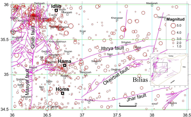
The epicentral map (Figures 5 and 9) has shown that the instrumental seismicity is very low along the northern segments of DSFS: Masyaf, Apamea and Ghab. A cluster of 4 events was located in the middle of the Ghab basin. One event of the cluster had a normal mechanism (Abdul-Wahed, 2012) in agreement with the NW normal fault associated with the local trans-tensional features observed by Brew et al. (2001b). The Rouj basin, ~24-km-long and up to ~5-km-wide, is bounded by left-lateral faults (Fig. 3). A cluster of 42 events was observed in this basin (Figure 9). The focal mechanism, calculated for the biggest events, has shown a sinistral mechanism trending NE in agreement with the main existent faults (Figure 7). A cluster of 17 events was observed at the northeast extension of St. Simeon fault around Shran city. At the northern end of the Ghab Basin, the El-Wastani mountain is bounded by Armanaz fault and Salqin fault in the east and west respectively. A cluster of 41 events was observed at the El-Wastani mountain This cluster could be related to Salqin-Armanaz faults. Asharneh plain is located in the east of the south part of the Ghab basin (25 Km northwest of Hama city) (Figure 9). A cluster of about 20 events was located in the Asharneh plain. Three of them were aligned in the NW direction and form a multiplet. The composite focal mechanism of these 3 events shows a normal fault mechanism (Figure 7) which could also be associated with local trans-tensional features. A cluster of 142 events was located between Hama and Rastan cities and aligned in the NW direction. It could be related to unmapped Hama fault.
c- Abd-el-Aziz uplift faults
The Abd-el-Aziz uplift faults, in the northeast of Syria, were roughly east-west striking and were active almost exclusively in the latest Cretaceous. These faults extend from the west through Abd-el-Aziz mountain ( ~100 km length, max. elevation 920 m) and eastwards well into Iraq (Figure 2). The most recognized earthquake along the Abd-el-Aziz uplift faults occurred in 1975 with magnitude of M≈5.2 (Ahmad, 2013). A cluster of 43 events was observed in the middle part of the Abd-el-Aziz uplift faults (Figure 5), where an event reached magnitude 4.7. Another cluster of 31 events was observed in the eastern part. Four events, aligned in the EW direction along the Abd-el-Aziz uplift, show nearly identical source mechanism solutions and have a sinistral mechanism trending EW (Figure 7). They might indicate shearing process in this direction.
d- Palmyrides Faults
The Palmyrides fold-thrust belt separates the Rutbah uplift to the south from the Aleppo plateau to the north (Figure 2). Many sets of weak events were located in the northern region of Palmyrides. They could be related to the faults: Ithrya, Okeirbat, Bishri, Jhar, Khnefice, Palmyra and others. The scattered seismicity, observed in the current study (Figure 5) and the previous ones (Brew et al., 2001) suggests that the Palmyrides region is still tectonically active. The Bishri fault system is probably a dextral strike-slip fault similar to the Jhar Fault. A magnitude Ms=4.9 earthquake, occurred on November, 20, 1994, was located near this fault, at a depth of 15 km, northeast of the mapped extent of the fault (Litak et al., 1997). The focal mechanism for a 1970 earthquake (Mb=4.8) was determined to be dextral but the initial solution for the 1994 event suggests sinistral motion (Dziewonski et al., 1995). Moreover, field evidence and kinematic models (Chaimov et al., 1993) are consistent with dextral motion along the Bishri fault. The strongest event that occurred on December 18, 1994 (Mc=5.0), was located at the northeast of Bishri mountain. It shows dextral motion on the NE striking nodal plane (Figure 7). It could be related to the Bishri fault. A cluster of 20 events was observed during the study period in the northeast of the mapped extent of the fault (Figure 5). In the southwestern regions of Palmyrides, a cluster of 10 events is located at the northeast extension of Damascus fault near Khan-Arus site (Figure 8), where this fault interacts with a secondary north-west fault. This cluster might indicate the activity of the secondary fault rather than Damascus fault. Another cluster of 7 events are aligned in the NE direction and located along the Zobeideh fault (Figure 7), where a doublet has been detected. This doublet has a sinistral mechanism trending NE, in agreement with the Zobeideh fault (Abdul-Wahed et al., 2011).
A cluster of 773 micro-events has been observed in Jayrud region. In this cluster, 660 micro-events have a magnitude of less than 2.0, they could be therefore induced by quarrying exploitation. The early works in Jayrud‘s quarries started in 2001 (Al-Tahan, 2014) but the induced seismicity didn’t appear until 2003 (Figure 10), where the exploitation has been extended to many quarries. Similarly, a cluster of 304 micro-events has been observed around Hyssia city and could be induced by quarry exploitations.
e- Northern extension of Serghaya fault
Serghaya fault can be traced approximately 125 km through the Anti-Lebanon mountains to the eastern edge of the Bekaa valley (Figures 8 and 10). Field evidence for Quaternary strike-slip faulting along the Serghaya fault is observed as far north as the village of Arsal, near the edge of the Bekaa valley (Gómez et al., 2003). The trace of the Serghaya fault is obscure towards to the north of this point. Its northern termination suggests a possible linkage with the Jhar fault as an oblique ramp or tear fault that bounds the Palmyrides fold belt (Gómez et al., 2006). Walley (1998) suggested that the Serghaya fault continues also in NNE into Syria, past Al Qusayr and SE of Homs, before splaying into the Jhar and Bishri faults within the Palmyrides fold belt. However, geological mapping in the vicinity of Al Qusayr has revealed no evidence of any such fault, and none has been noted during recent fieldwork in this area (Bridgland et al., 2003). In this study, a cluster of 60 events, aligned to the NE until the village of Alqaa near the Syrian-Lebanese border, was observed around the village of Arsal (Figure 8). This cluster could be associated to the northern part of Serghaya fault. The seismic activity in northern Lebanon, shown on the epicenters map, is concentrated on the northern part of Serghaya fault, which supports the finding of Walley (1998). Other cluster of 5 events was observed around Al Qusayr and makes probable the suggestion of linkage of the Serghaya fault with the Jhar and Bishri faults.
f- Aleppo plateau
The Aleppo plateau forms a central more stable region of low relief (Figure 2). The eastern and western margins of the plateau are poorly defined, especially near the DSFS, where several N-S to NE-SW strike-slip and normal faults splay out from the master fault. The Aleppo plateau is regarded as a platform with minor amounts of deformation compared to the Palmyrides (Zanchi et al., 2002). It is cut by some NE-SW faults which are probable zones of strike-slip (Al-Saad et al., 1992). The recently known earthquake in this plateau occurred in 1987 with magnitude of 4.8 (Ahmad, 2013). The seismic activity in the western margin along the DSFS, discussed above, could be considered as relatively high (Figure 11). However, it is very low in the eastern margin. In northern Aleppo, a cluster of 102 events is aligned in the NE direction and could be associated with NE Ikhtrin fault; another cluster of 26 events could be related to Manbeg fault. In the west of Aleppo plateau, Az-zawiyeh mountain overlooks the Ghab basin. It is bounded by NE-striking sinistral strike-slip fault. In this mountain, a cluster of 100 events was located.

g- Golan plateau faults
The Golan, situated at the SW of Syria, is an elevated basalt-covered plateau. To the north, it is bounded by the Hermon mountain anticline. About 180 events are located in Golan plateau and could be associated to DSFS. Some of them formed multiplets with events aligned in NS direction. Two multiplets have a sinistral mechanism trending NS in agreement with DSFS (Abdul-Wahed et al., 2011). Another multiplet has a normal mechanism trending NE and could be related to local trans-tensional faults that extend along the margins of DSFS.
h- Coastal range
The Syrian coastal range, occupies most of the Syrian onshore area at the west of the DSFS and Ghab basin. The stratigraphic relationships indicate that the uplift of the coastal range is a part of the extensive Syrian arc deformation (compressional folding along the eastern Mediterranean coast), documented in the Levant (Walley, 2001; Salamon et al., 2003, 2007; Yolsal et al., 2007; Carton et al. 2009; Eyal, 2011). The coastal range has clearly been affected by the propagation of the DSFS and the formation of the Ghab basin, resulting in the steep eastern limb (Brew et al., 2001), that created the extremely steep scarp on the eastern face of the coastal range alongside the Ghab basin. A cluster of about 46 events is located in northern of Tartous city. Another cluster of 81 events is located in south and south east of this city.
3- Occasional-type seismic activity
Some significant events can be classified as individual such as the earthquake of Palmyra 1996 and the events of Rutbah uplift. Those events seem to be apparently scattered during the study period, but they might be in reality linked with other events that occurred before or after this period. The study period of about 17 years, from 1995 to 2012, is very short in comparison with the estimated long return period for whole Syria of 200-350 years (Ambraseys and Barazangi, 1989). It is therefore not possible to conclude that some faults, such as the northern segments of DSFS, are inactive, depending on the recent instrumental seismicity qualified as short term observations. The high magnitude of some events of occasional-type, such as the earthquake of Palmyra, 1996, could be interpreted by accumulation the seismic energy during a long period of quiescence. One can conclude that the long period of quiescence along the northern segments of DSFS might accumulate the seismic energy and could at any time produce a big earthquake especially for the reasons mentioned above (geomorphic evidence for Pliocene, recent tectonic activity on the fault together with historical seismicity and GPS measurements). The scattered seismicity in the Palmyrides fold belt suggests that this region is still tectonically active.
Discussion
During the period of studyd 1995-2012, about 5000 local events have been recorded by the SNSN (Bulletins of SNSN, 1995-2012 2009 on the reference list!!!!). In total, nearly 3800 earthquakes were located with a location uncertainty of less than 10 km. Figure 4 shows that about 50% of the entire events are reliable locations with an average location uncertainty less than 5 km in horizontal and vertical directions. The average RMS for the whole dataset is about 0.5 sec. Most of the recorded events are located within the network and have relative small location uncertainty values. Therefore, locations of these events can be considered reliable for the following interpretation of the present work. The epicentral map (Figure 5) presents the geographical distribution of the seismic activity. The study of this local instrumental data has illuminated the general appearance of the recent seismicity in Syria and spotlighted some important observations:
The little amount of events, where the annual average of recorded events is about 292, which could be considered very low as compared with other parts of DSFS, such as Yammounah or Aqaba Gulf, indicates that Syria is actually passing through a relative quiescence period. For example, 2414 events were recorded in Aqaba Gulf in 1995 (Jordan Seismological Observatory, 1995) and 948 events in 1997 (Jordan Seismological Observatory, 1997). Furthermore, the instrumental seismicity of the eastern Mediterranean region shows that the southern part of DSFS is seismically the most active (Hofstetter et al., 2007; Imprescia, 2010; Imprescia et al., 2012). The most active area since the early 1980s was the Gulf of Aqaba, where thousands of small cluster earthquakes occurred in different regions of the Gulf of Aqaba during several months to few years (Baer et al., 1999; Klinger et al., 1999).
The epicentral map has shown that the main instrumental seismicity with many moderate earthquakes (Mc>4) is apparently concentrated on the Syrian borders: along the EAFS extending on the northwest borders and along the central segments of DSFS in Lebanon such as Yammouneh and Roum. The EAFS, including Latakia-Killis faults system, could be characterized by the highest instrumental seismicity in Syria.
The seismic activity inside Syria has produced events of low magnitude (Fig. 6), which consequently indicates that it is actually passing within a relative quiescence period as compared with other parts of DSFS (Meghraoui et al., 2003). Most of the recorded events are qualified as weak, where their average magnitude is approximately 2.0. Fig. 6 shows the frequency of the recorded events according to their magnitude, which varies between 1.0 and 5.6. Only 49 events have exceeded the magnitude of 3.0 during the period 1995-2003 (Abdul-Wahed and Al-Tahan, 2010). In the present study, only 470 events, which make 9% of the total 5000 events, have exceeded the magnitude of 3.0 during the period 1995-2012. The fitting Gutenberg and Richter relation to the observed frequency-magnitude distribution has shown a magnitude completness down to Mcompletness =2.5 (Figure 6). This indicates that not all micro-earthquakes (Mc<2.5) have been detected by the SNSN. Some events could be too small to be recorded on a sufficiently large number of stations to trigger the recording system in the SNSN, to initiate the location procedure, and thus the report of the event. The network operators decided that some micro-earthquakes below a certain threshold (Mc<2.5) are not of interest. The constants of the empirical Gutenberg and Richter relationship, a- and b- values, were evaluated using the LSM method (log N= 5.43-0.91M) and MLM method (log N= 5.2-0.73M).
According to the epicentral map, the recent instrumental seismicity inside Syria is characterized by many clusters of weak events (M<4) such as in southwest of Aleppo plateau. Some clusters were observed as swarm indicating the behavior of some faulting zones such as Serghaya fault, southwest Palmyrides faults and Bassit region faults (Figure 2).
The most important event was the earthquake of Palmyra which happened on December 24, 1996, with a magnitude of about 5.6 (Tan and Taymaz, 2003; Alchalbi, 2004). This event is located in Palmyrides fold belt that separates two relatively stable zones, Rutbah uplift, in the southeastern of Syria from Aleppo plateau in the northwestern of Syria. The earthquake of Palmyra has a sinistral mechanism trending NE (Figure 7), and can be related to Palmyra fault (Abdul-Wahed, 2012).
Conclusion
The instrumental seismicity of Syria during the period 1995-2012, has been characterized and documented in the present paper. In total, nearly 3800 micro-earthquakes were located with a location uncertainty of less than 10 km. Therefore, locations of these events can be considered reliable for the following interpretation. The correlation between the instrumental seismicity and the seismotectonic features was performed through the analysis of spatial distributions of seismic events and some focal mechanisms, where most epicenters appear to correlate with the regional strike-slip faults. The epicentral map has shown that the main instrumental seismicity with many moderate earthquakes (M>4) is apparently concentrated on the Syrian northwest borders along the EAFS, including Latakia-Killis faults system, where the highest instrumental seismicity in Syria has been observed.
This research allowed observing many types of seismic activity as follows: Swarm-type, Cluster-type, and Occasional-type. Many observed swarms have been correlated through the spatial distributions of the hypocenters with some active faults, such as Serghaya fault and the southwest of Palmyrides. The seismicity inside Syria was characterized by many clusters of weak events (M<4) such as the clusters on Latakia-Killis faults, Rouj basin faults, and northern Aleppo plateau faults. However, some significant events could be classified as individual, such as the earthquake of Palmyra, 1996, regarding the shortness of the study period. The geographical distribution of epicenters of a cluster could be related to an active fault. This correlation could be confirmed by the focal mechanism of some strongest events. As a consequence, many faults can be considered active in Syria. The observed swarms could give an insight on the seismic behavior of some active faults such as Serghaya fault, where many events striking in a relatively short period of time are followed by a long period of quiescence. The occasional-type of seismic activity could be interpreted as a very long behavior of some active faults.
The instrumental seismicity of Syria could be classified in general as low magnitude events. Most of the recorded events are qualified as weak, where their average magnitude is approximately 2.0. In the present study, only 470 events, which make 9% of the total 5000 events, have exceeded their magnitude of 3.0 during the period 1995-2012. The fitting Gutenberg and Richter relation to the observed frequency-magnitude distribution has shown a magnitude completness down to 2.5. This indicates that not all micro-earthquakes (Mc<2.5) have been detected by the SNSN. Regarding the low magnitude level of the recorded events, we can deduce that the seismic activity in Syria is actually passing by a relative quiescence. Such result may therefore be taken to support the finding of previous studies indicating that the seismicity in Syria tends to fade out with time, in line with the decrease of major seismic intensity which has occurred during the last millennium. This view, however, is inconsistent with both the historical records of large, devastating earthquakes, and the field observations that attest to the seismic activity and seismogenic potential of the DSFS. The discrepancy between measured rate of small-magnitude earthquakes (M <4) from instrumental records and large earthquake rates from paleoseismic records, as also observed on other faults, makes the fault’s behavior unpredictable. This discrepancy can be explained if we consider that the instrumental record lacks both moderate-to-large events and their aftershocks. Since the beginning of instrumental seismicity, the DSFS experienced only one large earthquake (M=7.2) that occurred in the Gulf of Aqaba on November 22, 1995.
The characterization of the recent seismic activity in Syria is not an easy task, due to the long return periods of large earthquakes, estimated in previous studies to be about 200-350 years, and to the shortness of instrumental seismicity, about 17 years. It is therefore difficult to discover all the active faults in the country. The long period of quiescence along some faults, such as the Ghab fault, accumulates probably the seismic energy and could produce a big earthquake at any time. The nonperiodic behavior of the DSFS over the millennial timescale makes it more difficult to meaningfully predict the probability for a large earthquake soon. Therefore, it is imperative to prepare for a large earthquake on the DSFS, which will occur sooner or later. The actual results, documented in this research, highlight the need and necessity of more detailed researches for a longest possible period of time.

