


 nueva página del texto (beta)
 Inglés (pdf)
 Artículo en XML
 Referencias del artículo
 Enviar artículo por email
 Citado por SciELO
  Similares en
SciELO
Similares en
SciELO 
 Permalink
Introduction
The intense process of urbanization started around 1960 in Brazil, was driven by the installation of several foreign automobile manufacturers, substantial investments in electricity generation and expansion of university education. The absence of urban planning has resulted in the use and occupation of the urban space in a disorderly way, with negative consequences in terms of urban mobility, basic sanitation and quality of life.
This process was accompanied by changes in consumption habits, which stimulated by means of intense advertising and encouragement in unbridled consumerism, has resulted in the expansion and the generation of waste in its different forms. The main form of final disposal of solid waste in Brazil are the sanitary landfills (59%), controlled landfills or dumps (41%), whose collection and final disposal are the responsibility of the municipalities. (IPEA, 2012; SNIS, 2013).
The organic matter generated in houses represents more than 50% of the mass of garbage collected, caused primarily from food waste, with maximum use of 3% of this material in composting (CEMPRE, 2013; ABRELPE, 2014).
The dumps are a form of packaging of waste which is characterized by its location is distant areas of urban centers, absence of any system of collection of gases or liquids produced by decomposition of organic materials, lack of coverage on the surface or soil sealing besides the lack of control on the proliferation of insects, rodents and birds that use these areas as a source for feed and shelter (Christensen, 2001; Tchobanoglous and Kreith, 2002; Reddy, 2011).
The absence of technical criteria in the planning of operation of these areas provides a broad spectrum of impacts on the environment: contamination of soil, ground-water and drainage due to gravity flow of leachate coming from the decomposition of organic waste, emissions of greenhouse gases (CH4, CO2); the risk of explosion by the accumulation of flammable gases (CH 4); risk of animals killing, plants and aquatic beings on the outskirts of the area; proliferation of serious human diseases caused by exposure to chemicals (metallic elements, organic and inorganic) and biological (virus, bacteria and fungi), among others (Tchobanoglous et al., 1993; Vesilind 2002).
In 2010 the National Policy for Solid Residues was implemented in Brazil by means of Law nr. 12.305 of 2010 (BRAZIL, 2010). This standard proposes the management of residues in face of a new system based on present concepts, explicit specifications and terms for implementation and regulation. This juridical instrument stipulated a term of 4 years, ended in 2014, for the banishing of procedures for waste disposition without technical criteria, or conversion of dumps into sanitary landfills.
In the face of legal requirements, in 6 years of validity of this federal regulation (2010-2016), approximately 60% of Brazilian municipalities have discarded household solid waste in landfills, in addition to the deployment of several actions for the reduction, reuse and recycling of waste, in an attempt to minimize the total volume of waste to be placed in landfills.
However, the adoption of actions and technical projects of treatment and recovery of the deactivated dumps is a recurring theme, which requires investment and action plans highly complex in some cases. Several small municipalities do not have the technical and financial resources for detailed studies. Partnerships between municipalities and universities are viable alternatives, inexpensive and suitable for coping with these issues.
The degree of technical difficulty in these cases is conditioned to issues such as: volume of waste conditioning, time of use of the area, proximity of drainage, slope, thickness and mineral constituents of the soil, composition of the bedrock, type and depth of the aquifer, porosity, permeability, among others (Lehr et al., 2001; Sara, 2003; Twardowska et al., 2006; Hernández-Soriano, 2014; Yung-Tse et al., 2014).
Special features related to environments with soil not very thick, exhibitions of rock on the surface and fractured groundwater aquifers, are elements that represent a highly complex geological environment, requiring differentiated negotiations regarding the diagnosis and planning of technical proposals for the recovery of contaminated areas.
Quantitative determinations about the levels and dispersion of contaminants in groundwater demand direct sampling by means of monitoring wells. However, the misplaced location of drilling points and sampling in fractured aquifer systems can induce the development of inadequate technical projects, with unsatisfactory results in terms of economy and efficiency.
Preliminary diagnostics by means of indirect procedures for research are highly advantageous in those cases where the application of geophysics shows satisfactory results in the investigation of a wide range of types of contaminants and diversity of geological contexts (Knödel et al., 2007, Rubin and Hubbard, 2005). The contrast of electrical properties characteristic of inorganic pollutants such as leachate when present in soils and rocks, justifies the adoption of Electrical and Electromagnetic geophysical methods in these cases (Meju, 2000; Shevnin et al., 2005; Chambers et al., 2006; Dena et al, 2012; Belmonte-Jiménez et al., 2012 EN LISTADO DE REFERENCIAS; Moreira et al., 2013; Delgado-Rodríguez et al., 2014; Ochoa-González et al., 2015; Moreira et al., 2016; Arango-Galván et al., 2016).
This paper presents the results of geophysical research in a deactivated garbage dump and currently under technical evaluation for preparation of integrated management, which involves new conformation of the relief, planting of grasses and trees, in addition to the remediation of contamination in the aquifer. From previous geochemical studies that demonstrate the contamination of the aquifer, the data analysis of electrical resistivity tomography (ERT) in 2D and 3D visualization products, aims to define the main zones of flow in a context of fractured aquifer, in addition to enabling the planning of technically effective remediation devices appropriate to the complexity of the local geological environment.
Location and history of the study area
The city of São Sepé is located in the central region of Rio Grande do Sul State, South of Brazil, having 23.798 inhabitants, with economy based on rice growing and extensive livestock farming (IBGE, 2010).
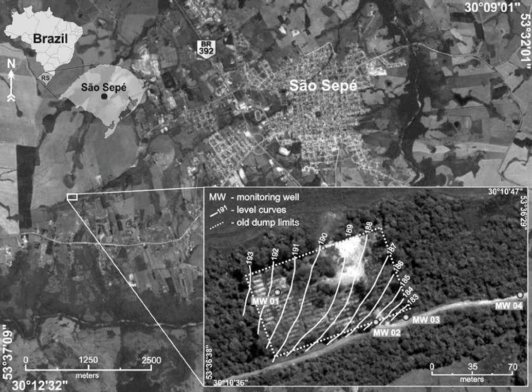
The area of the former municipality garbage dump has a total of 10.318m², with activities that started in 1989 and finished in 2004. Between 1989 and 1998, this area functioned as a garbage dump in the open air, where the urban solid waste was launched without any planning. The establishment of minimum technical criteria requirements from 1998 resulted in the release of waste into windrows, compacted by the transit of a track tractor and later covering of soil, although without the installation of any systems of waterproofing basement, collection of gases or liquids. The total volume of residues disposed in the area is estimated at 6.000.00 m³.
The site was closed to the launch of waste in 2004 and went on to serve as an area of transshipment of waste for final disposal in sanitary landfill in the Minas do Leão city. The area was finally closed in 2007, with a history of environmental and social issues, with invasion and housing of collectors of recyclable materials, waste incineration in the open air, with soil and groundwater contamination, and various violations of federal and state laws.
After summons and lawsuits, the municipal government has signed an agreement for the remediation of the area with the FEPAM (Rio Grande do Sul Environment Agency) in 2015. The initial studies counted with the installation of four monitoring wells for chemical analysis and verification of environmental impacts on the aquifer (Figure 1).
The regional geological context is represented by the São Sepé Granitic Complex, positioned at the northern end of the western portion of the Sul-Riograndense Shield (CPRM, 2000). The various constituent rocks are dated around 542±6Ma by U-Pb in zircon (Remus et al., 1997), a period corresponding to the Brasiliano orogenic cycle, tectono-magmatic responsible for intense genesis of granites recognized in various portions of the Brazilian territory (Bizzi et al., 2003).
The São Sepé Granitic Complex features elongated shape toward NE/SW, partially covered by sedimentary units, having dimensions of a batholith (Sartori & Rüegg, 1979). It is characterized by an acid intrusion with a wide variety of textures and reverse zonation with monzongranites in the central part and syenogranites in outlying areas (Gastal & Ferreira, 2013).
These rocks have brown-reddish color, granulation medium to coarse, and variations dominantly equigranular to porphyritic. In peripheral positions, microgranites and aplites occur in the form of dikes with fine granulation tissue, associated with quartz milky millimeter single or in swarms, which represent late magmatic manifestations. The quartz veins are centimeter to millimeter thickness and appear singly or in swarms (Sartori & Rüegg, 1979).
The regional character of structural context is defined by the predominance of fractures and faults groups in different positions in batholith granite. Directions N60° to N70° are predominant in the eastern end, in the west central portion directions between N50° and N55°predominate, in the east portion dominates the direction N25° to N40° and N115° to N130° (Gastal & Ferreira, 2013).
The location of studies is contained in the extreme northeastern part of the granitic batholith, characterized by discontinuities that are primarily oriented between N20°, N35°, N150° and N165° with clear indications of fracture joints. However, the structural discontinuity closest to the area of studies has N68° direction.
Locally it is possible to recognize the presence of soil with clay texture, with fragments of quartz, with a thickness that can reach up to 3m, as well as various surface granite exposures, with the presence of fractures and joints, and quartz in veins (Figure 2).

Initial studies of research for preparation of a remediation counted on the installation of four monitoring wells, by means of which it was possible to define the thickness of soil and groundwater level.
Well MW - 01 was placed in one of the highest places in the area, positioned at 191.7m of altitude and presented about 2m layer of soil and saprolite, with 0.84 m of additional fractured rock positioned 2.84m deep from the groundwater level. Well MW -02 is positioned at 185m altitude and has about 0.25m thickness between soil and fractured rock, with basal contact that defines the position of groundwater level. Well MW -03 is positioned at 182m altitude and 30m from well MW - 02, with approximately 1.45m layer of soil and saprolite, and 3.90m interval of fractured rocks, with the groundwater level positioned at 5.35m (Figure 3).
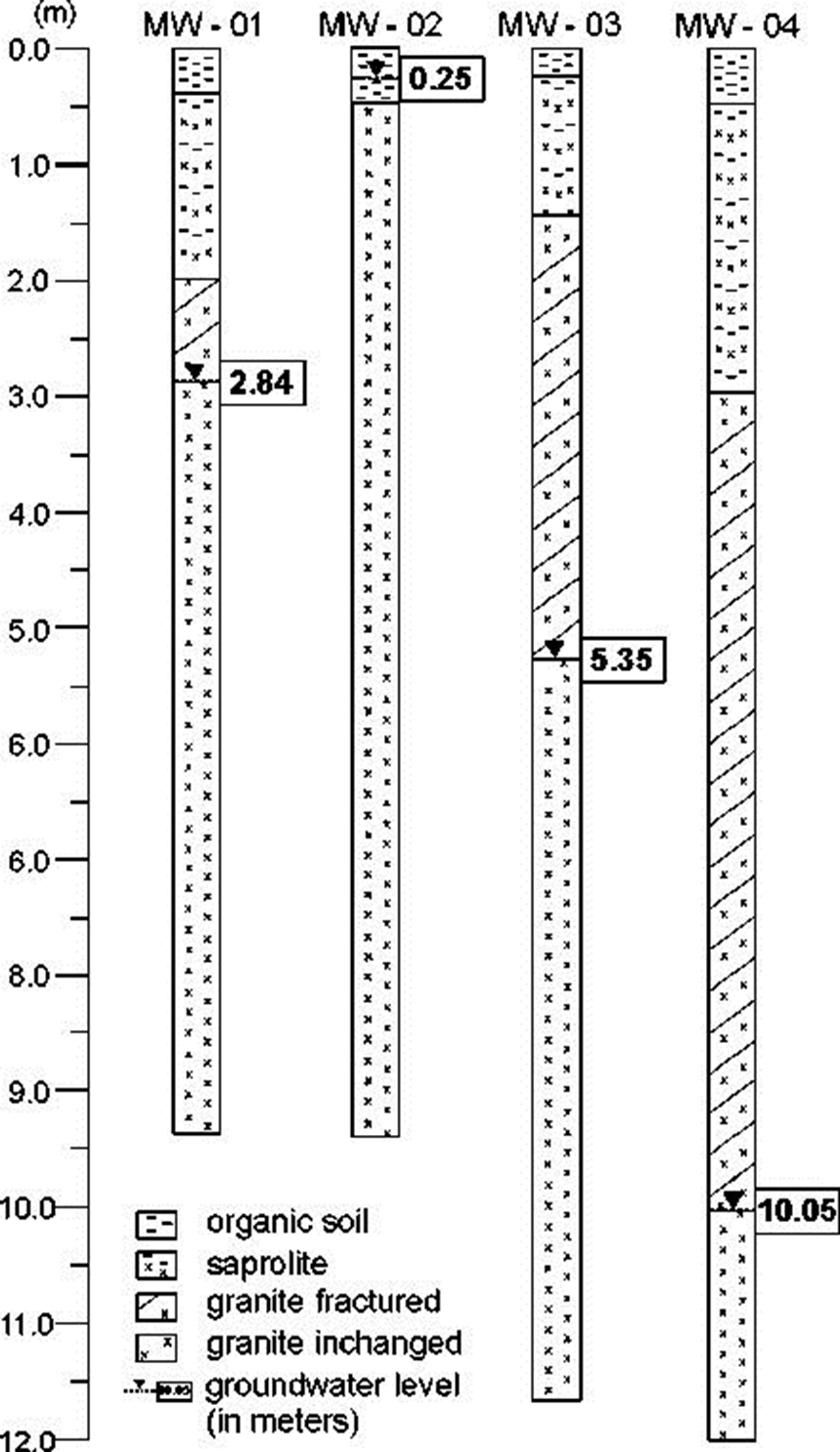
Well MW - 04 is positioned at approximately 100m from the area of study, scheduled to serve as a reference pattern for chemical groundwater analyses. It has a 3.00m layer of soil and saprolite, in addition to approximately 7.05m thick layer of fractured rocks, with the groundwater level positioned at 10.05m depth (Figure 3).
Chemical analyses in water samples collected in the set of wells installed in the area reveal changes in various parameters analyzed, with results above the Brazilian Standards (Table 1).
Table 1. Chemical analyzes in the groundwater samples
| Limit * | MW-01 | MW-02 | MW-03 | MW-04 | |
| Aluminium | 0.2 | 1.39 | 1.330 | 1.776 | 0.78 |
| Cadmium | 0.005 | <0.0006 | <0.0006 | <0.0066 | <0.0006 |
| Lead | 0.010 | 0.051 | 0.042 | 0.044 | 0.041 |
| Chloride | 250 | 21.8 | 32.7 | 102 | 4.04 |
| Condutivity | - | 518.4 | 899.7 | 1129.7 | 76.08 |
| Chrome | 0.05 | 0.06 | <0.003 | <0.003 | <0.003 |
| Iron | 0.300 | 3.473 | 1.076 | 3.318 | 0.783 |
| Manganese | 0.100 | 0.720 | 0.530 | 1.691 | 0.529 |
| Mercury | 0.001 | 0.0003 | 0.0038 | 0.0016 | <0.0002 |
| Nitrite | 1.0 | <0.006 | 0.530 | 1.691 | 0.529 |
| pH | - | 6.96 | 6.45 | 6.49 | 6.04 |
| Sodium | 200 | 35.8 | 54.5 | 104 | 4.54 |
| Total dissolved solids | 1000 | 342 | 594 | 732 | 44 |
| Sulfate | 250 | 30.5 | 74.6 | 67.8 | 1.14 |
*Defined by CONAMA 396/08 (National Counsel of Environment - Ministery of Environment - Brazil)
The geochemical anomalies related to the metallic elements such as lead, iron, manganese and aluminum, can be associated with the weathering of sulphide ores and micas, contained in quartz veins outlined in various exhibitions of the São Sepé Granite, resulting from hydrothermal processes occurring in the final stages of magmatic crystallization (Matos et al, 2004; Gastal & Ferreira, 2013).
However, it is notable the significantly increased levels of iron, manganese, mercury, nitrate and conductivity in well MW-03, in addition to other geochemical anomalies in the other wells. The pH variation is also relevant in terms slightly acid (between 6.04 and 6.96) and the very high levels of sodium, sulphate, nitrate and total alkalinity. However, the vast majority of elements analyzed occur at values below the limit of contamination stipulated by the federal law.
Materials and methods
The selection of the DC Resistivity geophysical method is based on history of use and occupation, coupled with previous data obtained through the monitoring wells, in addition to the contrast of electrical properties provided by the eventual presence of leachate in the soil and aquifer on comparisons with measurements of references to natural conditions for the area (Georgaki et al., 2008; Moreira et al., 2015).
Electric Resistivity Tomography (ERT) was used in a dipole-dipole array. The existence of fractures and faults with a high angle in the region and the possibility of contaminant flow in these locations, justified the selection of this dipole-dipole array. This array is characterized by the contrast of spread in electrical and potential fields, sensitivity and highlight in the recognition of similar structures (Arango-Galván et al., 2016; Delgado-Rodríguez et al., 2014; Moreira et al., 2016).
This array consists in the installation of pairs of metal electrodes along the line of research, for transmission of electric current and generation of electric field in depth (current electrodes), and later reading through pairs of reception electrodes (potential electrodes). The appropriate form of current and potential electrodes positioning allows to record electrical resistivity for different depth levels in the investigated line (Telford et al., 1990; Milson & Erikssen, 2011).
The data acquisition in the field was based on the following settings: 5m spacing between electrodes and measurements of electrical resistivity in 20 depth levels. Nine lines of electrical resistivity tomography routing were performed, five lines being 110m and four lines 160m extension, placed in mesh with spacing of 25 m between them (Figure 4).
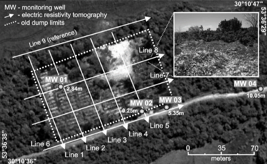
Figure 4. Electrical resistivity tomography lines and monitoring wells, with detail of residues exposed and groundwater level (in meters).
The positioning of the lines in the field considered the intersection of the main systems of fractures regionally recognized, in addition to the local topography and existing approaches in the area of study. It was possible to ascertain during the data acquisition in the field, that trees cover a large part of the waste and there are only some areas covered by grass allowing the recognition of partially exposed waste.
The equipment used was the resistivity meter Syscal Pro, manufactured by Iris (France) with a resolution of 1mV. This equipment is calibrated for measurements of resistivity through periodic cycles of alternating electric current and low frequency, a procedure that allows the filtering of noise from the acquired signal (IRIS Instruments, 2006).
The field measurements were initially processed with the software Res2Dinv, where, from the smoothed by inversion method (smooth inversion) bi-dimensional resistivity models were generated for the subsurface that consider the topography adjustment (Geotomo Software, 2013). The sections are presented in terms of distance x depth, with logarithmic graphic scale and intervals of interpolation of color values.
The method of inversion by smoothing uses the mathematical method of least squares, and through it, the software recognizes the terrestrial subsurface as rectangular blocks that have constant values for the investigated parameter (Geotomo Software, 2013). This optimization aims to reduce the difference between the apparent resistivity values, calculated and measured in the field, by adjusting the resistivity of the block model, whose difference is expressed by the RMS error (Root Mean Squared) (Loke & Baker, 1996).
After the 2D inversion, the data were gathered in single file, later used as a database for generating 3D maps and depth models. This process was developed in the Oasis Montaj platform, where the 2D data obtained with Res2Dinv program were interpolated and modeled by means of the minimum curvature method for enhancement of the extreme values in models of three-dimensional blocks, where the ERT lines were positioned. The works of Vieira et al., (2016) and Cortês et al., (2016) describe in detail the elaboration of 3D visualization models used in this work.
Results and discussion
An analysis of the main chemical and physical characteristics of the leachate from dumps and landfills is extremely important, often composed by several groups of pollutants (Christensen et al., 1994). These groups are: dissolved organic matter, expressed by the demand of chemical oxygen or total organic carbon, including CH4, volatile fatty acids and compounds more resistant as humic and fulvic; inorganic components such as Ca, Mg, Na, K, NH4+, Fe, Mn, Cl, SO42+ and HCO3-; heavy metals such as Cd, Cr, Cu, Pb, Ni and Zn; organic compounds derived from petroleum, which include aromatic hydrocarbons, phenols and aliphatic chlorinated.
The set of anomalous values described in the analytical results of groundwater samples in the site can be directly correlated to the percolation of leachate from the decomposition of organic matter, whose characteristic of acid pH also contributes to the dissolution and solubility of metals, eventually contained in waste or minerals from bedrock that support the aquifer (Farquhar, 1989; Kjeldsen et al., 2002).
This saline solution that makes up a set of inorganic elements, organic and metal typical of leachate from garbage dumps and landfills, is completely miscible in water and reaches the aquifer initially by gravity flow, then conditioned to the gradient of groundwater flow. In this sense, the possible leachate presence on the aquifer is recognized by increasing the electrical conductivity (Meju, 2000; Knödel et al., 2007).
The analysis of 2D inversion models allows to recognize areas of low electrical resistivity, values below 150 Ohm.m, compared to the values of reference for the area, limited to150 Ohm.m minimum value (Figure 5).
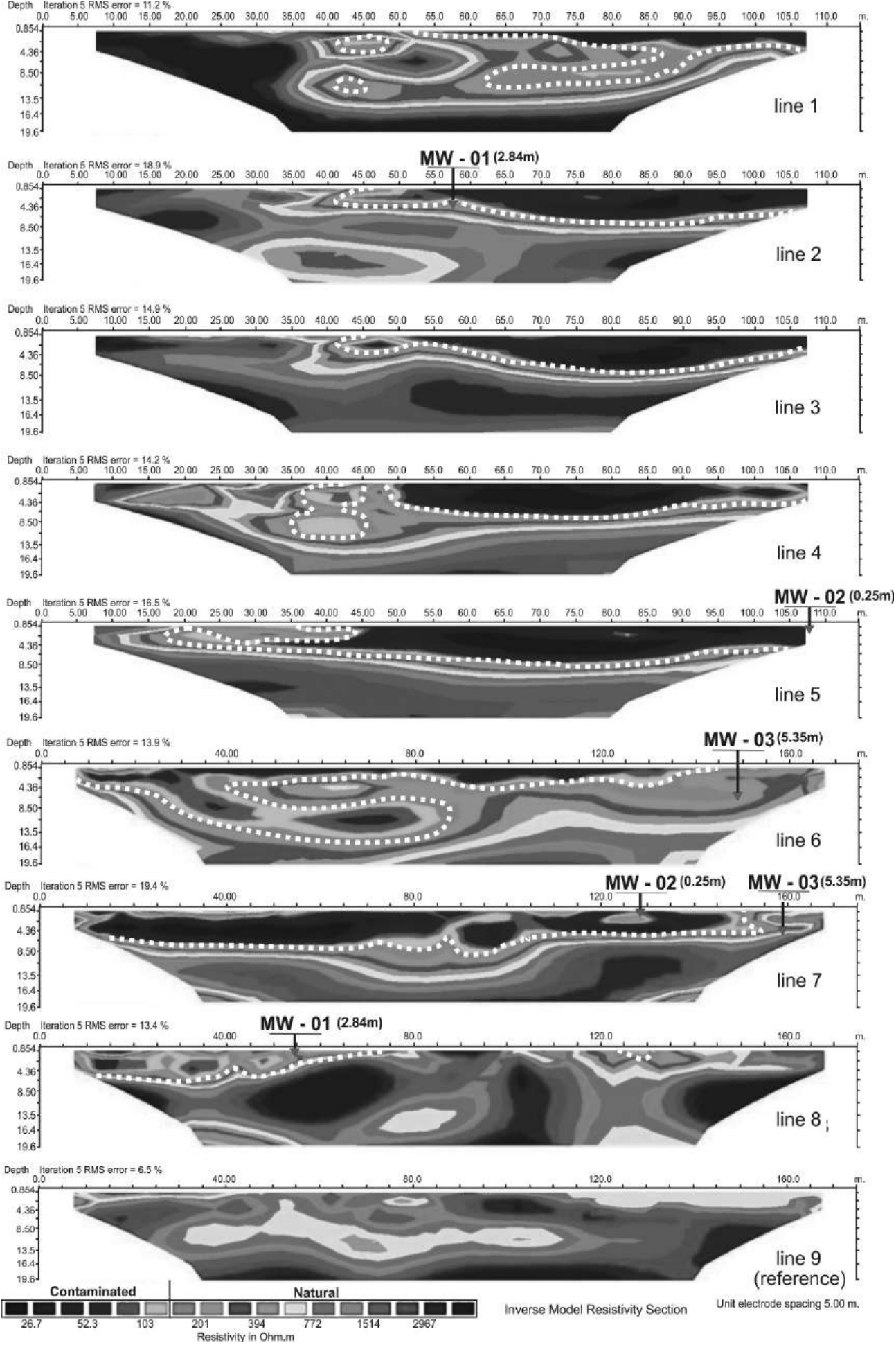
Figure 5. Inversion models of electric resistivity tomography, with limits of contaminated areas (white lines) and groundwater level in meters (red triangle).
The integration between the geophysical and geological data reveals the complexity of the geological environment of the area of study.
In the absence of previous geophysical surveys, the monitoring wells were drilled in the area according to the topographical criterion, i.e. MW-01 well was placed in the highest part of the area, followed by wells of lower elevation. This criterion was apparently based on the principle of a groundwater flow gradient parallel to the topography.
The weathering intensified by water infiltration and hydration of the rock forming minerals in the fracture plans contrasts with the process that applies at intervals of massive rock, occurring slowly and resulting in large blocks of rock. The differential weathering produces highly complex flow paths and the soil cover makes it difficult on the surface, to estimate groundwater flow or contamination of surface origin.
In the 2D inversion models a delimitation of the interval of 150 Ohm.m was possible, revealing a wide variation in lateral depth of the bedrock, responsible for supporting the aquifer, besides of discontinuities which hinder the communication in the lateral and vertical direction of the fluid. The differential weathering has provided an unconfined configuration system for the aquifer (lines 2, 3 and 7), aquifer partially confined (lines 1, 5 and 6) and fractured system (lines 1, 2 and 4). The vertical and side discontinuities should reflect the presence of bedrock in blocks between systems partially isolated from the fractured rock.
ue to the total miscibility of leachate in groundwater, the percolation of the pollutant in groundwater aquifer is subject to the elements of flow present in the area of study.
The lateral complexity in terms of structural, flow discontinuities, and their reflections in the pattern of groundwater flow can be analyzed from the integration of 2D models in 3D visualization models, for different depths.
Up to 5m depth a large area occurs with values related to the presence of leachate (below 150 Ohm.m), in a range where soil and saprolite predominate, with portions of high resistivity which indicate the presence of non-altered bedrock (values above 1500 Ohm.m) (Figure 6).
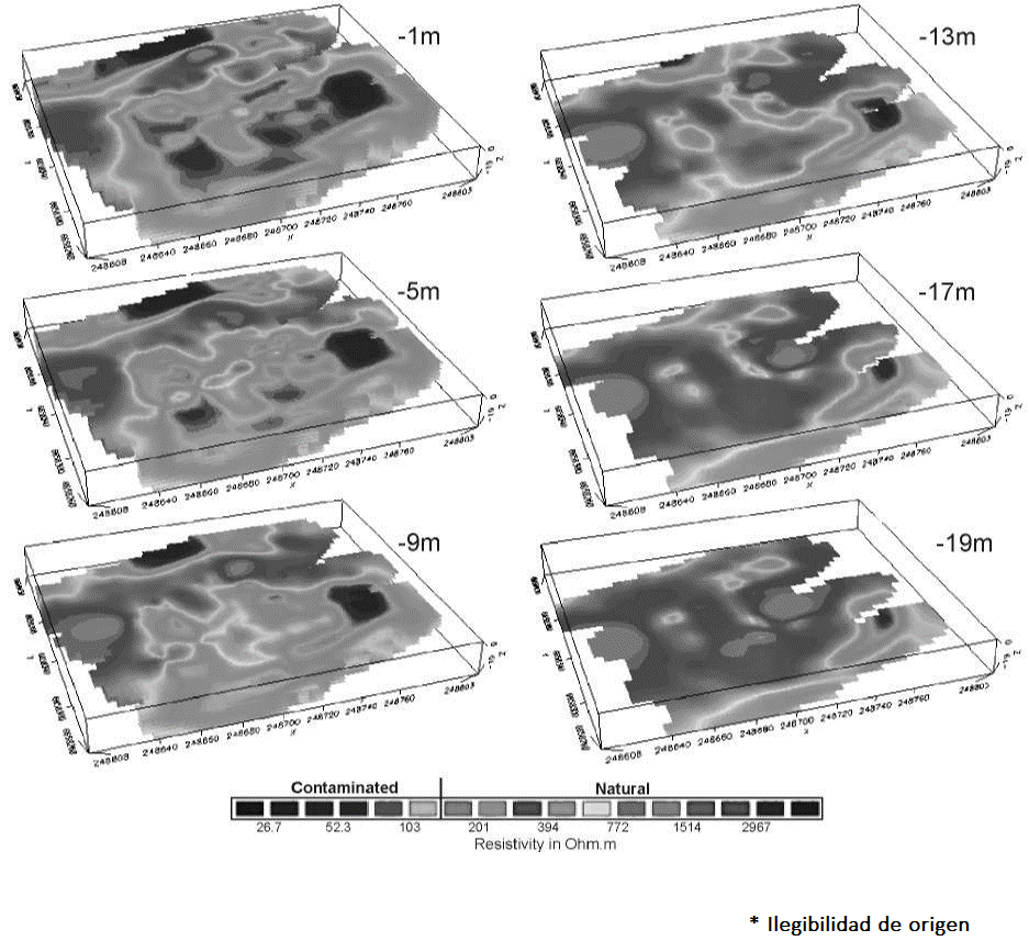
However, the analysis of geological and hydrogeological data of the wells profile reveals a great variation in thickness of soil, saprolite, fractured rock, depth of non-fractured rock and, as a consequence, in the position of the aquifer level. The great lateral variation on the groundwater level between wells MW-02 and MW-03 is a clear indicator in this sense.
At 9m depth a substantial reduction of areas of low resistivity occurs, concentrated in two distinct areas. From 13m there is a predominance of resistivity values, which indicate the growing predominance of bedrock, but with the existence of vertical fracturing which probably affects the groundwater flow towards greater depths. The range of low resistivity between 13m and 19m suggests a conic geometry with channeling of flow at depth, with a tendency to continuity below 19m (Figure 6).
The areas of low resistivity relating to the presence of leachate were modeled in isosurfaces of 50 Ohm.m, in an attempt to analyze three-dimensional architecture and its relations with the geological structures. The existing zone in the NW has an elongated shape in the N58° direction, conic geometry and a tendency to close at 13m depth (Figure 7).
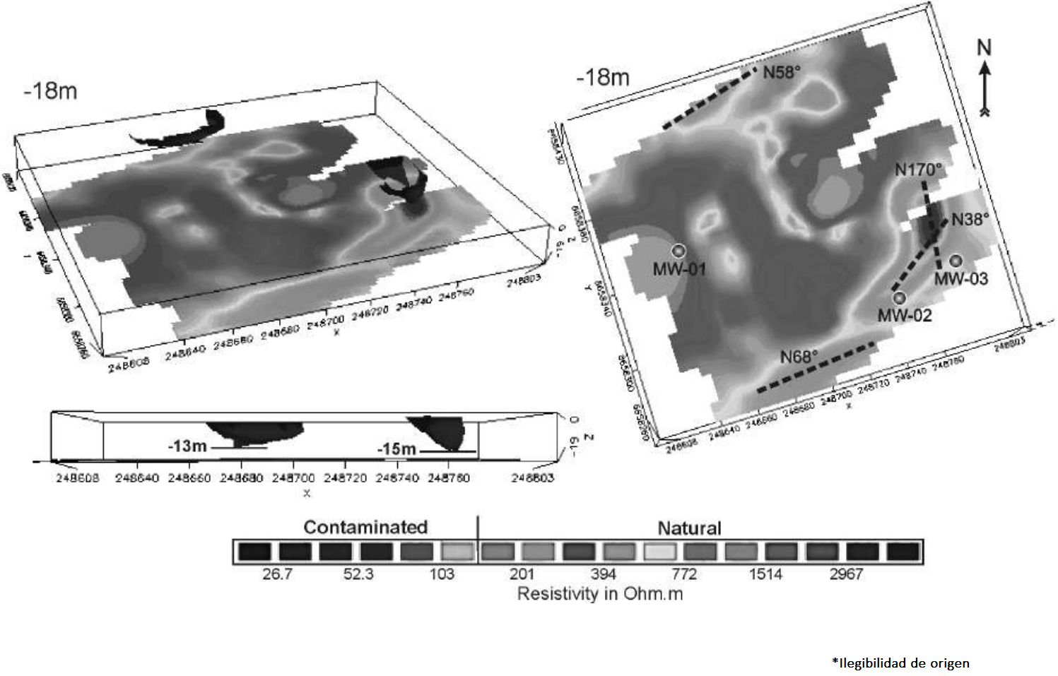
Figure 7. Resistivity map for -19m depth, with isosurface of the 50 Ohm.m, monitoring wells and directions of fracture planes
The existing zone in the SE portion is also characterized by the tendency to closing at depth, although in this case, with ellipsoid shape and possibly conditioned to a system of joint fractures at N38° and N170° directions, which provides the shaping of isosurface modelling at 15m depth, but with an indication of flow beyond the maximum depth of geophysical investigation (Figure 7).
The position of the monitoring wells does not coincide with the areas of low resistivity, an indication of inadequate leasing of drilling. Well MW-01 presents, in comparison, the lowest levels of salts (sulfate, sodium, nitrate, chloride, total dissolved solids and electrical conductivity) (Table 1). This well was placed near the areas of bedrock outcrop, with shallow aquifer level and tending to lateral flow in the opposite direction to the well, as per crosschecks of data with line 8 (Figure 5).
Wells MW-02 and MW-03 were positioned near a zone of low electrical resistivity and have high levels of salts. Well MW-03 is very close to the area of low resistivity of the SE portion of the area and presents higher values of electrical conductivity and total dissolved solids as compared to well MW-02, more distant from this zone.
Conclusion and recommendations
Past issues about the deposition of household solid waste result in environmental problems today and require solutions in terms of research and technical planning in the management of soil and groundwater contamination. Geological circumstances, such as groundwater flow in a fractured system and the complete miscibility of inorganic contaminants in groundwater, are factors that make the research and the treatment planning actions of these areas something substantially complex.
Preliminary investigations in the area of study consisted of a history of use and occupation of the area, followed by the installation of four monitoring wells, for determining the thickness of soil and rock horizons, depth of the aquifer level and water collection for chemical analyses. The wells were aligned according to the local slope, based on the premise that groundwater flows on a surface parallel to the topography.
Joint analyses of regional structures and local geology revealed the high local hydrogeological complexity due to the existence of a system of structural discontinuities in a granite batholith, set that supports an aquifer partially unconfined and partially fractured. The variation in the degree of weathering between fractured and massive areas resulted in thicknesses of soil and saprolite laterally variables, in addition to the existence of bedrock surrounded by soil. These factors provide a wide variation in the depth of the aquifer, as well as a migration from systems partially confined in the fractured system.
The analyses of 2D inversion models shows details about lateral variations and indicates the existence of a salt solution that makes the aquifer an electrical conductor in the dump area, when compared to natural data obtained in the reference line of natural electrical resistivity. Results of chemical analyses in monitoring wells showed changes in several parameters, with emphasis on elements that typically constitute the leachate, in addition to some metals possibly leached by acid attack in quartz veins, which has the potential of hydrothermal mineralization by sulfides in the bedrock.
The interpolation of tomographic sections in 3D visualization models, integrated with geological and structural data, provide a well-suited analysis of the groundwater flow. The ranges up to 5m depth are characterized by large areas of low resistivity associated with the leachate percolation in soil and saprolite, within a context of groundwater flow in a predominantly porous system. From 13m depth large areas of high resistivity dominate and isolated and targeted to low resistivity concentrations, possibly aligned in zones of flow in the fractured system in granite, where it is possible to highlight two expressive zones positioned in portions NW and SE in the area. Modeling of these zones indicates a conical geometry with channeling of flow in depth related to fractures and joints of fractures.
The geophysical data reveal the inappropriate location of the monitoring wells due to disregard of groundwater flow in the fractured system, although they provide results that reveal the groundwater contamination. Proper planning for treating the contaminated area necessarily depends on direct investigations in order to prove the geophysical clues.
The geophysical results revealed the hydrogeological complexity on the site and the inadequacy of the procedure of direct investigation. The correlation of low resistivity areas with chemical analyses showed the contamination of the aquifer, The existence of preferential zones of flow and accumulation of leachate, showed the relevance and effectiveness of the method in the investigation of complex contaminated areas and in the planning of treatment actions.
Factors such as the closure of the area for final disposal of solid waste in 2004, the restriction of new contributions of organic matter and the action of processes of consumption and conversion of this material over the last 12 years, provide the increasing exhaustion of the generation source of leachate.
Based on the definition of preferential flow and the accumulation of leachate zones mainly in the context of the fractured rock, the installation of wells for pumping and treatment of contaminated water is recommended, in an attempt to restrict the pollutants flow and a progressive decontamination of the old dump area.

