


 text new page (beta)
 English (pdf)
 Article in xml format
 Article references
 Send this article by e-mail
 Cited by SciELO
  Similars in
SciELO
Similars in
SciELO 
 Permalink
Introduction
Serghaya fault is a branch segment of the main Dead Sea Fault System (DSFS) in south-western Syria (Figure 1). Until 1995, it has not been considered as active branch since the Pliocene (Butler et al., 1997) and our knowledge of this part of DSFS was relatively limited. However, the results of paleoseismological trenching (Gómez et al., 2001; 2003; Nemer et al., 2008) strongly exhibit that this fault could be capable to generate a destructive earthquake and could be an important element in the regional seismic hazard assessment. The seismic potential of Serghaya fault in areas adjacent to major cities, such as Damascus, justifies the necessity and the need of characterizing the seismic activity of this fault. Asfahani and Abdul-Wahed (2013) have established an instrumental earthquake catalogue for the Serghaya fault for the period
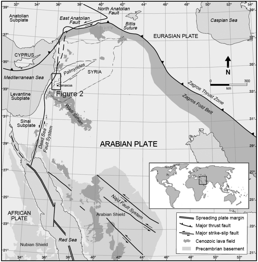
Figure 1 Regional tectonic map of the northern Arabian Plate and surrounding regions (modified from Brew et al., 2001). The rectangle shows the location of Figure 2.
Tectonic Setting of the region
The DSFS constitutes a plate boundary separating the Arabian plate from the African one, and contains their comparative motion as a system of sinistral fault branches (Figure 1). The northward movement of the Arabian Plate is faster than the African Plate, where the GPS measurements predict the total relative motion at the restraining bend to be ~6.8 mm yr−1 (McClusky et al., 2003). This relative motion of the two plates is taken up by the DSFS. Even though, there are many observed focal mechanisms all through the DSFS, however, the analysis of fault plane solutions of the main earthquakes confirms the left lateral nature of the DSFS (Salamon et al., 2003). A set of deep pull-apart basins have been developed by the extensional mechanism associated with the prevailing of the left lateral motion of the DSFS. Such basins can be created in topographical lower areas (Ben-Avraham and Schubert, 2006). In fact, the DSFS could be divided into three main sections including the southern part, a 200 km long Lebanese restraining bend, and the northern part, which meets northwards with the East Anatolian Fault in southern Turkey (Figure 1).
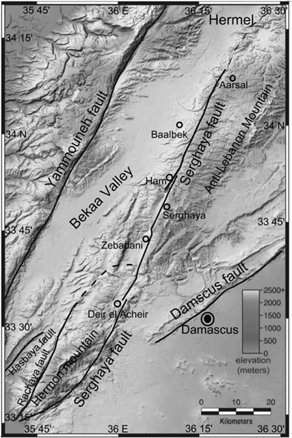
Five fault segments are branching out within the restraining bend from the DSFS; these are: the Yammouneh, Roum (in South Lebanoun), Hasbaya, Rachaya, and Serghaya faults (Figure 2) (e.g., Walley, 1988; Heimann and Ron, 1993). The northern DSFS, in Lebanon and Syria, has been considered as a sequence of transpressional steps-over, along which the left-lateral slip is apparently slower than the relative plate motion (Westaway, 1995; Gómez et al., 2007). The DSFS has not been regarded as a transform fault zone since 1995 (Westaway, 1995).
Local tectonic setting
The Serghaya fault branches out from the DSFS near Lake Tiberias (32.75 N, 35.60 E in the South-West of Syria) and extends along the Syrian-Lebanese border with a general trend of N30ºE (Dubertret, 1955) (Figure 2). Many geomorphic expressions have been observed along Serghaya fault such as the alignment of linear valleys and large stream valley deflections, which indicate a clear leftward deflection (Gómez et al., 2003). The young fault scarps and other features, such as offset streams, attest to recent coseismic ruptures (Nemer et al., 2008). The geometries of left-stepping faults are systemically seen at the elongated basins through the Serghaya fault zone, suggesting a pull-apart mechanism for the basins formation (Gómez et al., 2001, 2003; Nemer et al., 2008). The largest examples of such geometry are the fault steps-over at Deir el Acheir and Ham (Figure 2). Since the pull-apart basins that are developed along the concerned fault, their presence in a regional compressive system basically results from local left stepping and/or bending of the main left-lateral motion (Nemer et al., 2008). The shear indicators in deformed upper Pleistocene lacustrine sediments in the southern Zebadani basin (Figure 2) predominantly demonstrate the left-lateral slip along this portion of the Serghaya fault (Gómez et al., 2001; 2003). According to Gómez et al. (2001; 2003), an apparent strike-slip duplex led to the development of the Hermon mountain block, including the Serghaya and Rachaya faults segments (Figure 2). It is believed that these two faults are structurally interconnected as movement on one fault may enhance the corresponding movement on the other one (Nemer et al., 2008). Consequently, the Serghaya and Rachaya faults could delineate together an active seismogenic fault system with respect to restraining bend of Lebanon. On the other hand, the Serghaya fault can be traced approximately for about 125 km through the upper cretaceous carbonate bedrocks of the Anti-Lebanon Mountains to the eastern edge of the Bekaa Valley (Figure 2). Along the Serghaya fault, many important field evidences for Quaternary strike-slip faulting have been observed as far north as the Lebanese village of Arsal (Figure 2) (Dubertret, 1955; Gómez et al., 2003). The trace of the Serghaya fault is obscure towards the North of this point, where it disappears near the Baalbek city within the western edge of Anti-Lebanon mountain range (Dubertret, 1955). Its northern termination proposes a probable connection with the Jhar fault (Figure 1) as an oblique ramp or tear fault that bounds the Palmyrides fold belt (Walley, 1998; Gómez et al., 2003; 2006). Moreover, it has been proposed by Walley (1998) that the Serghaya fault may extend towards NNE inside Syria, passing through Al Qusayr (34.50 N,36.6 E) before splitting into the Jhar and Bishri faults within the Palmyrides fold belt (Figure 1). However, the fault could not be detected in the vicinity of Al Qusayr (e.g., Kozlov et al., 1963; Ponikarov et al., 1966), and nothing has been noticed during the recent fieldwork in this area (Bridgland et al., 2003). This might be due to the presence of a thick cover of recent formation. Many evidences attest that the latest destructive earthquake was located on the Serghaya fault and could be younger than the earthquakes of Yammouneh fault (Gómez et al., 2001; Tapponnier et al., 2001; Daeron et al., 2005). The Serghaya fault is, therefore, the most plausible source of earthquake hazard in Syria and Lebanon (Daeron et al., 2005).
Seismic activity
The instrumental seismicity in the central and northern DSFS, as observed from 1900 to the present day, depicts little earthquake activity in contrast with the historical records (e.g., Ambraseys and Jackson, 1998). The low level of seismicity and the scarce focal mechanisms could yield and probably support the idea of an apparent behavior of seismic quiescence for this part of the DSFS (Gómez et al., 2003). Asfahani and Abdul-Wahed (2013) have found that the earthquake activity of Serghaya fault passes actually through a relative quiescence, in comparison with other active parts of DSFS such as Yammounah or Gulf of Aqaba (Figure 1). However, this result is not consistent with both the historical seismic activity (Sbeinati et al., 2005), and the field observations that confirm the activity and the seismogenic potential of Serghaya fault (Meghraoui et al., 2003). Several destructive earthquakes, occurring during the historical times, have been archived in the historical sources (Sbeinati et al., 2005). The results obtained from paleoseismic studies propose that Serghaya fault is active with slip rates of about 1.4 mm/year (Gómez et al., 2001). The last historical earthquake implicated about 2-2.5 m of sinistral displacement and corresponds to historical earthquake of 1759. The average dislocation of about 2 m suggests that such event corresponds to an earthquake of M >~7 with a mean return period of about 1700 yrs (Gómez et al., 2001, 2003; Meghraoui et al., 2003). Instrumental seismicity of the eastern Mediterranean region shows that the southern part of DSFS is seismically active. The Gulf of Aqaba (29.0 N, 34.9 E in Figure 1), has been the most active area since the early 1980s, where thousands of small earthquakes have been recorded during several months. The activity reaches a point of highest development on November 22nd, 1995, when an earthquake of Mw7.1 (Baer et al., 1999; Klinger et al., 1999), was the biggest seismic event occurring along the DSFS during the 20th century.aftershock sequence, of about 60 earthquakes, continued for more than one year with many events surpassing magnitude 5.0.
Syrian seismic network evolution
In 1985 the General Establishment of Geology and Mineral Resources (GEGMR), responding to an initiative proposed by the Program for Assessment and Mitigation of Earthquake Risk in the Arab Region (PAMERAR), started the design and implementation phases for the construction of the Syrian National Seismological Network (SNSN). The network’s design objective was to monitor all discernible earthquake activity along the DSFS and its related branches in Syria and nearby Lebanon such as Serghaya fault. The nine seismic stations of the southern sub-network became operational in late 1994 and early 1995 and allowed to record the micro earthquake activity that occurred on November 22nd. 1995, along the Serghaya fault. The eleven stations of the northern sub-network followed the next year to complete the twenty stations of the western SNSN. The SNSN has been officially operated since January 14, 1995 (Dakkak et al. 2005). The seven eastern stations were added in April 2002, where two of them were three-component seismic stations. In 2003, the SNSN consists of twenty seven short period (1 Hz) stations of ~50 km seismograph spacing.
Data and resources
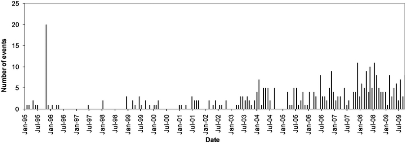
All data used in this paper came from three seismic bulletins published by: the Syrian National Seismological Network (SNSN bulletins, 1995-2009), the Atomic Energy Commission of Syria (AECS bulletins, 1995-2009) and the Geophysical Research Arrays of Lebanon (GRAL bulletins, 1995-2009). The data, gathered from these three seismic bulletins, have been used for construction of a combined catalogue (Asfahani and Abdul- Wahed, 2013). This published catalogue is the objective for more detailed analysis than was possible earlier to investigate the seismicity patterns for this fault. This analysis enables us to better understand the nature of Serghaya fault. Based on this catalog, a total of 350 events, occurring during the period of 15 years from 1995 to 2009, have been identified along Serghaya fault. The statistical analysis of the Serghaya catalogue indicates that the average occurring frequency of the recorded events is approximately four events by month. Such earthquake activity rate is considered as relatively very low. Some months, however, show a relative increasing in the recorded events number, which reaches 11 events per month, while other months do not indicate any recorded events as shown in Figure 3. Some temporal clustering can be generally observed in many time intervals such as November 1995 and 2008. On Figure 3, the increase of seismic activity can be observed since 2003. This observation could be related to the effect of a better operation of the national seismic network, where the southern sub-network started independently to detect and record the seismic events on the Serghaya fault zone. In this way, the acquisition system became more sensible and thereby additional micro-seismic events can be recorded. So, this increase could not reflect any significant changes regarding the fault behavior. Magnitudes in the three mentioned bulletins are calculated from the coda wave duration via the formula (GRAL bulletins 1995-2009): MC = 0.08 + 1.63 * log (T) + 0.009 * D,(1) Where D is the epicentral distance (in km) and T is the coda duration (in seconds).Most of the events, included in the established catalogue, qualified as weak and their average magnitude is about 2.8. Figure 4 shows the frequency of the recorded events according to their magnitude. Magnitude of most events varies between 2.6 and 3. It is obvious that the earthquake activity of the Serghaya fault during the studied 15 years has produced low magnitude events, in comparison with other parts of DSFS, such as Yammounah or Gulf of Aqaba. For example, 115 of the recorded events in 1995 in the Gulf of Aqaba have a magnitude greater than 4.0 (Jordan Seismological Observatory, 1995).
Spatial clustering
Being of low magnitude, the recorded events were only observed by local stations located near Serghaya fault. In addition, the low magnitude of those events could affect the accuracy of the determination of wave-arrival times, hence the computed locations of the epicenters are not precise. A geographical distribution of these epicenters around Serghaya fault is presented in Figure 5. It is shown that those events extend from the divergence point of the Serghaya fault from the DSFS up to north-east Lebanon with a scattered pattern at both sides of Serghaya fault. Such a scattered distribution is justified by the low accuracy of the epicenter determination. Those events could probably occur on secondary faults, located near Serghaya fault. Although the scattered distribution of the epicenters, many spatial clusters can be observed. For example: the cluster of tens of events at Deir el Acheir, the cluster of about 25 events at Ham, and the cluster of about 30 events north of Arsal (Figures 2 and 5). Some clusters could be related to the fault steps-over; e.g., at Deir el Acheir and Ham. Others clusters could be related to the Northern extension of Serghaya fault.
Deir el Acheir clustering
Deir el Acheir region is nearly a Northward elongated basin, where, Serghaya fault spreads into two parallel branches at a distance of about 500 m (Figure 2). The left-stepping of Serghaya fault, observed at this elongated basin, suggests a pull-apart mechanism for the basin formation (Gómez et al., 2001; 2003; Nemer et al., 2008). The contact zone between Jurassic bedrock and Quaternary deposits, observed along the eastern branch, attests recent fault movements (Nemer et al., 2008). The epicenter map (Figure 5) shows a clustering of events at Deir el Acheir (Figure 2). Some events in this cluster correspond to the micro earthquake activity that occurred on November 22nd, 1995, along the Serghaya fault. This remarkable activity has been regarded as a rare earthquake phenomenon. According to Mohamad et al., (2000), this earthquake activity was triggered immediately following the 1995 Aqaba earthquake along the Serghaya fault at a distance of about 500 km, where a total of 21 events occurred during the first three and half hours following the mainshock. The focal plane solution of the largest event, of magnitude MC3.7, confirms the primary sinistral motion on Serghaya fault, predicted by local geology and plate tectonic considerations (Gómez et al., 2001; 2003; Meghraoui et al., 2003; Abdul-Wahed and Al-Tahan, 2010; Abdul-Wahed et al., 2011).The mechanisms for the small events of the Deir el Acheir cluster in 1995 were computed. Their uncertainty is large, but their variety provides valuable insights about the complexity of Serghaya fault and the structures along it (Figure 6). A good similarity can be observed between the fault plane solutions of events 1995/11/22-09:15:03.4 and 1995/11/22-09:15:33.9 in
Figure 6. This similarity allows linking them with the sinistral Serghaya fault. In order to improve the quality of calculated mechanisms, the Composite Fault Plane Solution (CFPS) technique has been applied on those clustered small events. The advantages of the CFPS

Figure 4 Distribution of recorded events according to their magnitude during the period of 1995-2009.
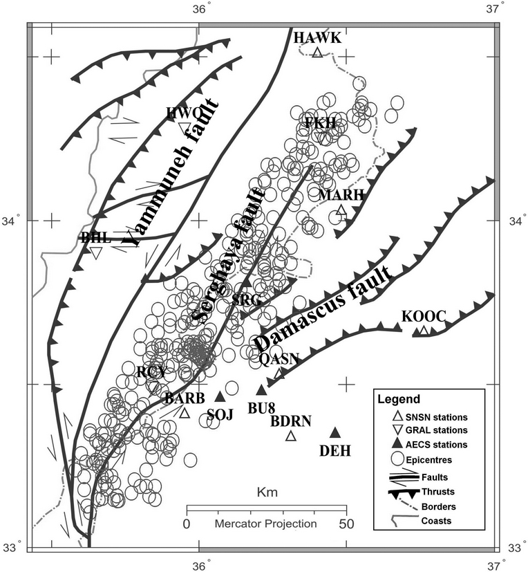
Figure 5 Geographical distribution of the earthquake epicentres around Serghaya fault during the period of 1995-2009.

Figure 6 The fault plane solutions of the events 1995/11/22-09:15:03.4 (left) and 1995/11/22-09:15:33.9 (right) are presented with lower-hemisphere equal-area projection: white quadrants for dilatation and black for compression.
Ham clustering
Ham region is also a Northward elongated basin, where, Serghaya fault spreads into two parallel branches (Figure 2). Further northeastward, around Ham, the epicentral distribution (Figure 5) shows a cluster of about 25 events. In this region, the Serghaya fault bends to the north and steps approximately 500 m westward (Figure 2). Therefore, Ham basin could be considered as a pull-apart basin resulting from such stepping bend (Gómez et al., 2001). The stepping segment is correlated with faulted rocks in soil matrix suggesting a recent fault movement (Nemer et al., 2008). The cluster of about 25 events at Ham could be related to the recent faulting and the stepping bend of Serghaya fault at this region.

Northern extension of Serghaya fault
The seismic activity in North Lebanon, shown on the epicenters map (Figure 5), is concentrated in the Hermel region (GRAL, 1995-2009). This activity could be related to the Northern extension of Serghaya fault (Figure 5). It displays a remarkable clustering of low-magnitude earthquakes. A cluster of about 30 events was observed around the village of Arsal. It is aligned in NE until the village of Alqa’a (Figure 2). The spatial distribution of this cluster could be associated to the northern part of Serghaya fault, which supports the finding of Walley (1998). Other cluster of ten events is observed near the Syrian-Lebanese borders and makes plausible the suggestion of linkage the Serghaya fault to the Jhar and Bishri faults (Figure 1) (Walley, 1998). It is probable to deduct that the Serghaya fault extends to the Hermel region, where this seismogenic zone could coincide with the proposed location of that linkage.
Discussion and conclusion
The seismicity related to the Serghaya fault, during the period between 1995 and 2009, displays a remarkable clustering of low-magnitude earthquakes. The spatial and temporal clustering have been observed regardless the evolution of the seismic networks. The observed spatial clusters could be probably related to the fault steps-over; e.g., at Deir el Acheir and Ham. Some clusters, located in the Hermel region, indicate the activity of the Northern extension of Serghaya fault. It is possible to deduct that the Serghaya fault extends to the Hermel region, where this seismogenic zone could coincide with the proposed location of linkage the Serghaya fault to the Jhar and Bishri faults, suggested by (Walley, 1998). Such evidence completes the findings of previous studies, which have demonstrated that the latest destructive earthquake was located on the Serghaya fault and could be younger than the earthquakes of Yammouneh fault. Therefore, Serghaya fault is, probably, the most plausible seismic source in Syria and Lebanon. The palaeoseismic investigations along the southern DSFS have, during the past decade, documented indications for long-term seismic behavior such as temporal clustering (e.g., El-Isa and Mustafa, 1986; Marco et al., 1996; Zilberman et al., 2000).The temporal clustering can be, therefore, an important characteristic of seismic activity along the DSFS. This clustering could have deep effects on the earthquake prediction. As discussed by Marco et al. (1996), temporal clustering of earthquakes may reflect a bias in ‘earthquake cycle’ for the northern part of DSFS. Several possible processes can cause temporal and space clustering such as the alternating periods of activity (Marco and Agnon, 2005). According to Ambraseys (1978), seismic activity has alternated between the North Anatolian and the East Anatolian major fault systems as a way of plate translation on longer time scales. The alternation phenomena might occur between the faults branches of DSFS in Lebanese restraining bend: Yammouneh, Roum, Hasbaya, Rachaya, and Serghaya faults. While a fault is active, the others store the elastic energy. The actual relative quiescence on Serghaya fault can be, therefore, regarded as alternating period of seismic activity with other faults within the Lebanese restraining bend.

