


 nueva página del texto (beta)
 Inglés (pdf)
 Artículo en XML
 Referencias del artículo
 Enviar artículo por email
 Citado por SciELO
  Similares en
SciELO
Similares en
SciELO 
 Permalink
Introduction
Reaching 5023 meters above sea level (asl), Tungurahua (01°28' S, 78°27' W) is a young andesitic volcano, located 140 km southeast of Quito, in the Ecuadorian Andes (Figure 1A). After 75 years of quiescence, Tungurahua awoke in 1999 with a small explosion, beginning an eruptive period extending to the present. Short stages of low-to-moderate explosive activity accompanied by tephra fall, lava emissions, pyroclastic density currents (PDCs), and lahars have characterized the volcano's behavior (Hall et al., 1999; Le Pennec et al., 2008; Hall et al., 2013).
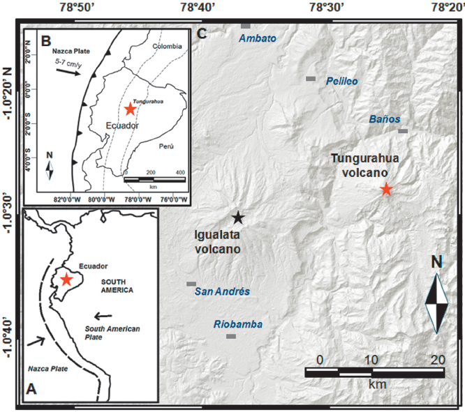
Figure 1 Location map of Tungurahua volcano. A: Location map of the study area in the context of South America. B: Tungurahua volcano in the geodynamic context. The Ecuadorian volcanic arc is represented by dotted lines. C: Main towns around the Tungurahua volcano.
The Volcanic Ash Advisory Center (VAAC) issued around 8000 reports of tephra emissions from Tungurahua volcano between 1999 and 2013, indicating its high level of activity. Staff of the Geophysical Institute at the National Polytechnic School (IG-EPN) and the Institut de Recherche pour le Développement (IRD) carried out field mapping, sedimentological analysis, and volumetric estimations of tephra from the 1999-2001, 2006, 2010, 2012 and 2013 eruptions (eg. Le Pennec et al., 2004; Ruiz et al., 2004; Troncoso et al., 2006; Bustillos, 2010; Bustillos et al., 2011; Le Pennec et al., 2011; Eychenne et al., 2012; Bustillos et al., 2013; Bernard et al., 2013; Eychenne et al., 2013). Moreover, in 2007 IG-EPN deployed "ashmeters" in a systematic network for monitoring tephra fall (Bustillos, 2010; Bustillos y Mothes, 2011; Bernard, 2013).
Fifteen years after its re-awakening, Tungurahua continues to be restless and its activity has forced people to learn how to live with persistent eruptions. In this paper we present a chronology of the last 15 years of eruptive activity (1999-2014), with special emphasis on the distribution, characteristics and volume of tephra emissions, and their impact and importance.
Background of the volcano
The Tungurahua stratovolcano has a conical shape with flanks of 30° to 35° inclination, and a summit crater 500 m in diameter. The volcano was built on a basement of Paleozoic to Cretaceous metamorphic rocks in the Cordillera Real (Aspden et al., 1994), locally intruded by granitic plutons of Paleozoic to Jurassic age (Litherland y Egüez, 1993). Two violent sector collapses 30,000 and 3000 years before present destroyed earlier volcanic structures and the present volcano is built upon their remnants (Hall et al., 1999; Jaya, 2004; Molina et al., 2005; Le Pennec et al., 2006; Bustillos, 2008). Historical eruptions took place in 1641-1646, 1773-1781, 1886-1888, 1916- 1918, leading up to the current 1999-present eruptive phase. Most of these eruptions were moderate to large in size, sufficient to achieve volcanic explosivity index (VEI) of 3 to 4 (Table 1). Eruption products during the history of the volcano range from andesite to dacite (SiO2 54-67% wt), but in historic times most have been andesitic (SiO2 ~58 % wt) (Hall et al., 1999; Bustillos, 2008, Samaniego et al., 2011).
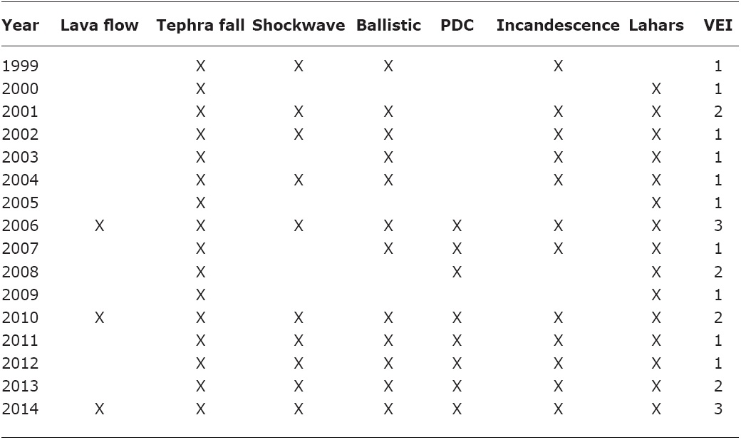
Table 1 Synthesis of the eruptive activity from 1999 to 2014 at Tungurahua volcano. Relevant volcanic phenomena are mentioned and the Volcanic Explosivity Index, VEI (Newall and Self, 1982) has been assessed using the volume of tephra emitted over each year and the highest eruption columns reported for these events.
Overview of the 1999-2014 eruptions
The Geophysical Institute has monitored the volcano since 1988 in cooperation with U.S. Geological Survey (USGS), IRD and other institutions (http://igepn.edu.ec/index.php/nosotros/patrocinadores). As a consequence of the robust IG-EPN monitoring network at Tungurahua, this Institute has provided detailed reports (http://igepn.edu.ec/index.php/tungurahua/informes-tungurahua), which document the various types of activity of the last fifteen years (Table 1). This activity can be divided into four eruptive stages (Figure 2A), as follows:
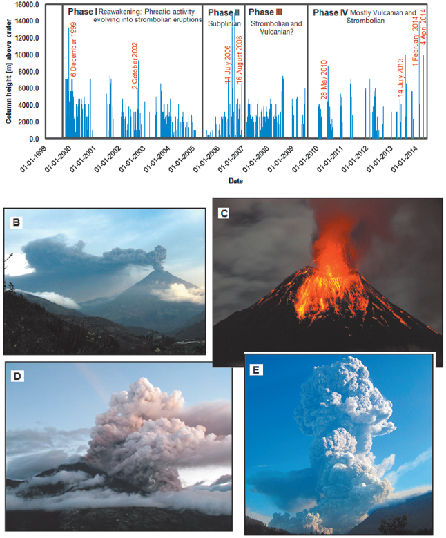
Figure 2 Chronology and phenomenology of the Tungurahua eruptions between 1999 and 2014. A: Eruption columns height vs. time. Column heights measured in use of geostationary satellite imagery and flight reports are provided by the VAAC (http://www.ssd.noaa.gov/VAAC/ARCH99/archive.html#TUNG). The four eruptive phases are distinguished and each most relevant eruption is mentioned. B: Low altitude (~1.0 km above the crater) tephra emissions forming an ash-loaded eruption plume. C: Typical Strombolian activity with discharge of metric-sized ballistic bombs. D: Explosive eruption on August 16th, 2006, with the formation of a PDC on the southwestern flank. E: Eruption column of February 1st, 2014. PDCs emplaced on all the flanks of the volcano.
Phase I
This phase occurred between 1999 until 2005. Before the eruption onset, seismicity and fumaroles increased due to magmatic intrusion. A fluctuating eruption column of 6-12 km asl (above de sea level), reached a peak of intensity on December 6th (1999) with a height of 18 km asl (Le Pennec et al., 2011). The activity included progressively stronger steam emissions, tephra explosions (Figure 2B), releasing of incandescent blocks and shockwaves, followed by lava fountaining activity of Strombolian eruptions (Figure 2C) in 2002, 2003 and 2004, interpreted as the magma input, reservoir disruption, and ejection of low volumes of magma (Samaniego et al., 2011). Quiet periods were <3 months and were frequently intercalated with eruptions, which suggested repetitive intrusions of andesitic (58-59% wt SiO2) magma from depth at low rates (Samaniego et al., 2011). Eruptive activity during 2005 was almost totally absent.
Phase II
A detailed summary of this eruption period can be found in Steffke et al. (2010). Activity increased gradually from January to April 2006. From May to the first days of July strong explosions occurred, and were heard at a distance of 20 km and shock waves were felt and windows shook 10 to 15 km away from the volcano (Barba et al., 2006). Events of July 14th and August 16th produced severe PDCs (Figure 2D), followed by a lava effusion. Five people died as a consequence of these PDCs at Palictahua, 7 km south of Tungurahua ́s summit. Details of the PDCs sedimentology are in Hall et al. (2013), Douilliet et al. (2013a, b) and Bernard et al. (2014). The 2006 eruptions were interpreted as a new, deep, hot, and volatile rich andesitic (58-59% wt SiO2) magma that entered a more evolved and degassed magma reservoir, and rapidly ascended to the surface (Samaniego et al., 2011; Eychenne et al., 2013; Myers et al., 2014). This eruption was classified as Subplinian.
Phase III
Subsequent to the explosive events of 2006, a third phase from 2007 to 2009 was characterized by reduced activity. Only small to moderate Strombolian events and a possible Vulcanian eruption occurred in 2007, February and August 2008, and the first half of 2009.
Phase IV
The latest phase has been occurring since 2010. PDCs from column collapse (sometimes immediately after the eruption) occurred in the first half of 2010, accompanied by eruption columns reaching 7 km above de crater level (acl) and the formation of a lava lake inside the crater signaled the ascent of magma. On May 28th, an explosion produced a column that rose 10 km (acl) into the atmosphere, and bombs 20 cm in diameter fell out to 5 km from the vent. On July 2010, the first reported purely-Vulcanian event was seen (Bustillos, 2010) and by November 22th a new Vulcanian explosion ejected lapilli-sized fragments as far as 10 km from the vent (Bustillos, 2010). Myers et al (2014) suggested that the 2010 eruption was the result of a separate recharge and mixing magma events that occurred shortly before eruption. From February to April; August 18th-20th; and December 4th -16th, 2011 volcanic activity produced PDCs that coursed down all the flanks, but none of them affected populated areas. In 2013, Tungurahua erupted four times with mostly Strombolian activity lasting between 17 and 39 days (Vallejo et al., 2014). The largest eruption in 2013 took place on July 14th, with a 10 km high ash cloud and generation of PDCs. The year 2014 will be remembered for two major Vulcanian eruptions, one on February 1st, which was preceded by a short and striking volcanic tremor (VT) swarm plus several months of volcano deformation (Vallejo et al., 2014). The eruption column reached 14 km above the crater and PDCs sped down along eight valleys, reaching the zone of the main road at the base of the edifice in several locations (Douillet et al., 2014) (Figure 2E). The second eruption occurred on April 4th and consisted of a short explosion, following 48 h of notable increase in VT and low to moderate explosions, producing an eruption column that reached 10 km above the crater (J.E. Romero, pers. comm., August 20th, 2014). Lava flew down the west flank on April 10th and afterwards new Strombolian eruptions occurred in August 2014.
Tephra deposits
Overview of previous research
Most of the research on Tungurahua tephra deposits of 1999-2014 focused on their distribution (isopach, isomass maps) (Figure 3) and volume (eg. Le Pennec et al., 2004; Troncoso et al., 2006; Bustillos, 2010; Le Pennec et al., 2011; Eychenne et al., 2012; Bustillos et al., 2013; Bernard et al., 2013; Eychenne et al., 2013). A few studies described their sedimentological characteristics in the period 2006-2014 (eg. Eychenne and Le Pennec, 2012; Eychenne et al., 2012; Eychenne et al., 2013). Indirect methods for determining tephra discharge rates have been applied at Tungurahua using the models of thermal plumes (eg. Ruiz et al., 2004; Bustillos et al., 2011) and eruption mechanisms have also been studied (eg. Bustillos, 2010; Bustillos et al., 2013; Narvaez et al., 2014). Bustillos and Samaniego (2011) have processed the data of tephra volumes between 2001 and 2010 in order to obtain values of magnitude and intensity for classifying these eruptions, using the scheme of Pyle (2000). These data are useful in tephra dispersal models, quantification of released materials and understanding of eruption dynamics.
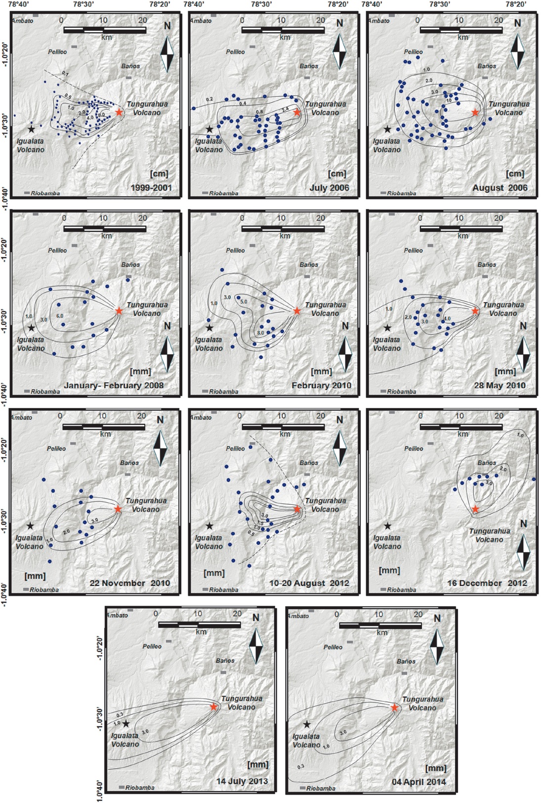
Figure 3 Isopach maps for the period 1999-2014 at Tungurahua volcano. Maps modified from Le Pennec et al. (2011), Troncoso et al. (2006), Bustillos (2010), Bernard et al. (2013) and unpublished material from the April 2014 eruption (J.E. Romero, pers. comm., August 20th, 2014). These maps have been drawn with the help of numerical modeling using Ash 3D code (see Schwaiger et al., 2012). Blue circles represent the data points of thickness measurements.
Spatial distribution
At present, 11 isopach maps displaying the geographic distribution of the fallout deposits have been reconstructed (Figure 3). During the 15 years of activity, 70% of tephra fall affected areas west and west-southwest of the volcano (Figure 1c). Less than 10% of the tephra fell to the southwest or west-northwest, and less than 5% fell in areas to the northeast or south southwest. An exceptional case of tephra distribution was observed during the February 1st, 2014 eruption, when fine ash fell more than 100 km to the north (Quito and Ibarra) and south (Cuenca and Loja). The most critical zone of tephra airfall deposition is an elliptical area west of the volcano and over the volcano's flanks, where total deposit thickness exceeded 10 cm. For the whole eruptive period and including the effects of wind erosion, sites like Palitahua and San Juan, 5 km from the crater, accumulated tephra thickness of 4 and 8 cm, respectively.
Components and Grain size
During the period analyzed, components in tephra have consisted in juvenile scoriae (dark, light or reddish in color) (Figure 4A), with mainly Plagioclase (Pl) and Pyroxene (Px) crystals (Figure 4B); accessory lithics (mostly dark, dense and blocky) (Figure 4C); juvenile pumice, juvenile glass shards and tubes (Pelee ́s hairs and tears) (Figure 4D, E); aggregates (Pl and Px assemblages) (Figure 4F) and oxidized lithics (eg. Bustillos, 2010; Eychenne and Le Pennec, 2012; Eychenne et al., 2012; Eychenne et al., 2013; Bustillos et al., 2013; Narvaez et al., 2014). A subpopulation of grain sizes from -4 to 10 Phi (fine lapilli to very fine ash) within bimodal distributions, due to elutriation of material from PDCs, was reported (Eychenne et al., 2012).
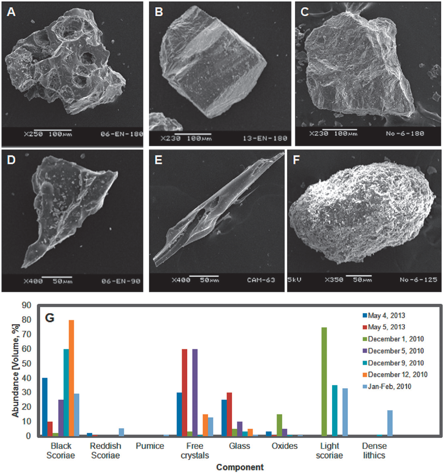
Figure 4 Components of the tephra fall deposits observed from 2006 to present. Views of Scanning Electron Microscopy (SEM) are presented for samples collected from deposits of the 2010 eruptions by Bustillos (2010). A: Scoria fragments. B: Free crystals. C: Lithics. D: Volcanic glass. E: Pele's tears-shaped volcanic glass. F: Aggregates. G: Variations of components for the 2010 and 2013 eruptions. Data from Bustillos (2010) and Bustillos et al. (2013).
The August 2006 eruption deposit consisted of six main classes of particles: 1) ragged, dark to brown andesitic scoriae; 2) light-toned, highly vesicular juvenile silicic (61.1-62.5 wt% SiO2) pumices; 3) euhedral Pl and Px irregularly coated free crystals; 4) dark-blocky, microcrystalline non-vesicular dense lithics; 6) assemblages of Pl and Px crystalline aggregates and 6) reddish subrounded, moderate vesicular scoriae (Eychenne et al. (2013).
The behavior of the 2010 eruption was studied thoroughly by Bustillos (2010). He interpreted the scarce lithic and crystal content, in addition with the dominantly Strombolian activity on January-February, as the transitional opening of the conduit. In contrast, the events of May 28th and November 22th produced highly vesicular fragments of hydrovolcanic origin, Pelee's tears, dense accessory andesitic lithics, scoriae and scarce free crystals consistent with Vulcanian eruptions. Most of the samples from the 2010 tephra fall deposits had grain sizes between 0 and 5 phi (from coarse to very fine ash), presenting unimodal distributions, and in a few cases bimodal distributions were observed in samples associated to fine ash input from co-ignimbrite fallout due to PDC elutriation (Bustillos, 2010).
The eruptions of May 4th and 5th, 2013 produced deposits consisting of: 1) blocky shaped black scoriae; 2) reddish sub-rounded to angular scoriae; 3) free anhedral crystals of Pl, Cpx and Opx; 4) volcanic glass with shard morphology; 5) Fe-Ti oxides; and 6) rare pumices with tabular an fibrous morphology (Bustillos et al., 2013). Between May 4th to the 5th the abundance of black scoria decreased from 40 to 10 %; crystals increased from 30 to 60%, pumice particles became absent and appearance Pele's tears reflected a transition from a Vulcanian-dominated to an Strombolian style with lava fountaining. Samples of the March and July 2013 eruptions contained a large amount of oxidized rocks, free crystals, dense accessory lithics, and juvenile material (both pumice and scoria) revealing a Vulcanian mechanism. Pumice and scoria increased with time after the onset, suggesting an evolution from discrete explosions to an open-vent behavior (Narvaez et al., 2014). Samples of March and July 2013 show mostly unimodal grain size distributions (Narvaez et al., 2014; Figure 4G). Meanwhile, Douillet et al. (2014) have reported that variation in the components and particle rounding in the PDCs of 1st February 2014 eruption suggested in- situ abrasion depending on the flow path and type of blocks, which phenomena probably did not have affected the tephra fall grain size distribution of this last eruption. Also, early observation (February) of the mantling zones of singed vegetation indicated the impact of hot co-ignimbrite clouds. This aspect needs to be addressed in a near future. The latest eruptions of February and April are not yet described in terms of their deposits, and research on this matter is required.
Size and parameters of the eruptive activity
During Phase I (1999 to fall 2004) the volcano released nearby 25 x106 m3 of bulk tephra (Wright et al., 2012). The events of July 14th and August 16th, 2006, (Phase II) were the largest recorded at Tungurahua in the entire eruptive cycle in progress, and released 42 and 26 x106 m3 of tephra fallout and PDCs, respectively (Troncoso et al., 2006; Eychenne et al., 2012; Hall et al., 2013). Around 1.5 x10⁶ m3 of tephra were produced in Phase III. After that, the largest volumes of tephra discharge during Phase IV occurred on July 14th, 2013 (calculated in 1.7 x10⁶ m3); February 2014 with >8 x10⁶ m3 (Vallejo et al., 2014) and April 4th, 2014 that reached ~1.0 x10⁶ m3 (J.E. Romero, pers. comm., August 20th, 2014). In summary, a total volume of 0.11 km3 in tephra fallout was released between 1999 and 2011 (Bustillos et al., 2011), closing in 2014 near to 0.13 km3. This is ~25% of the minimum released tephra bulk volume, reported for the 2008 major Subplinian phase of Chaitén's eruption, of 0.5 km3 (Alfano et al., 2012). The average rate of tephra discharge (Q) increased by more than two times from Phase I (Q ~ 8700 m3/day) to the period since 2006 (Phases II to IV) (Q ~ 19000 m3/day) (Figure 5A).
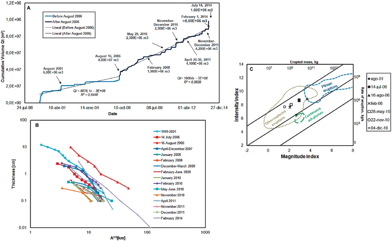
Figure 5 Size of the 1999-2014 eruptions at Tungurahua, A: Cumulative volume of the tephra fallout deposits since 1999, modified from Bustillos et al. (2011), Vallejo et al. (2014)and unpublished material (J.E. Romero, pers. comm., August 20th, 2014). B: Plot of area vs. thickness following the scheme developed by Pyle (1989) applied to theTungurahua tephra fall deposits. Based on the data from Jaya (2004), Bustillos et al (2014), Le Pennec et al. (2011), Troncoso et al. (2006), Bustillos (2010) and Bernard et al. (2013). C: Magnitude and intensity plot (Pyle, 2000) of the largest Tungurahua eruptions before 2014 (Modified from Bustillos and Samaniego, 2011). Areas contouring the different eruption types after Pyle (2000).
Following the approach of Walker (1980), the plot of tephra deposit area [km2] vs. thickness [cm] indicates that most of the tephra fall deposits are of Strombolian and Vulcanian types. In fact, a general summary of the thickness vs. area 1/2 of each fallout deposit has been plotted (Figure 5B). The August 2006, and 1999-2001 deposits are the largest and tend to be close to the field of the Subplinian and Plinian fallouts. In contrast, the November 2010 is the smallest deposit (Figure 5B).
In terms of magnitude and intensity, the major eruption of August 2006 was the largest in the entire period, reaching 3.7 and 9.0, respectively, on the Pyle (2000) scale which quantifies the power of eruptions, so it can be used in a global classification of these genetic events. Using this approach, Bustillos and Samaniego (2011) observed that: the eruptions of August 2001 are included in the field of "continuous ash clouds"; the eruptions of July 14th (2006), February 2008, May 28th (2010), November 22th (2010) and December 4th (2010) fall in the field of "other explosive eruptions" which refers to all explosive events smaller than Plinian or Subplinian; and, finally, the August 2006 major eruption is in the lower part of Plinian events (Figure 5C). Other eruptions have not been classified with this method due to lack of necessary data.
Variability, Impacts and opportunities from the study of tephra falls
These observations indicate that tephra falls at Tungurahua during the last fifteen years have been produced by different eruptive styles: short-lived explosions, Strombolian eruptions, hydro-volcanic interactions triggering Vulcanian eruptions, and one Subplinian event. Transitions between these eruptive styles have been commonly observed (specially from Vulcanian to Strombolian styles) during the 1999-2014 eruptions, as seen in the variations of tephra components and volcanic phenomena directly observed. While not studied herein, the characteristics (column height, duration, and dispersion of ash) of the February 2014 eruption are descriptive for a major Vulcanian eruption, similar to that on July 14th, 2006). This assumption must be supported with a successful quantification of emitted materials. While the 1999-2001 deposits are close to the field of the Subplinian eruptions, this is an example of a cumulative tephra of several short-lived eruptions and doesn't represent a single high intensity eruption.
The eruptions of July and August 2006 and May 2010, produced PDCs, representing increased explosivity compared to the Strombolian events that characterized its behavior since the renewal of activity in 1999 (Myers et al., 2014). Throughout the events of May 28th and November 22th, 2010, February 4th, 2012, July 14th, 2013, February 1th and April 4th, 2014 a more recurrent and explosive dynamics is evident. This is supported by the increase in Q over time, which could be explained by 1) an increase in frequency of short-lived explosions and 2) recurrence of large-volume explosive events. As reported for recent 2006 and 2010 eruptions (eg. Samaniego et al., 2011; Eychenne et al., 2013; Myers et al., 2014), both short-lived and large-volume eruptive events may be caused by continuous ascent of small, and gas-rich magma batches.
Tephra falls have extensively affected the areas around the volcano (Figure 1c), and sites to the south and west have experienced severe damage to agriculture and infrastructures (eg. Le Pennec et al., 2004; Le Pennec et al., 2011). House roofs have collapsed under the weight of tephra in addition to the weight of rainwater, and also acidic rain has degraded infrastructures (Le Pennec et al., 2011). Close to the volcano in towns such as San Juan, Laurelpamba and Palitahua, which received more than 6 cm of tephra deposits, many houses experienced partial destruction of their roofs by the fall of bomb-sized (11 cm diameter) clasts in 2006. According to IG-EPN reports, rapid rainfall runoff and associated erosion of the pyroclastic deposits caused 795 lahar floods from 2000 to 2010. No fatalities have been reported as consequence of tephra fall, but PDCs killed five people in 2006. Sword-Daniels et al (2011) provide information of tephra impacts of Tungurahua eruptions on infrastructure and public services, including impacts on water supplies, wastewater, transportation and agriculture.
While the effects of volcanic ash in human health and life are well-known, stories of social resilience and adaptation are surprising and common at Tungurahua. Worldwide research projects, such as the Strengthening Resilience in Volcanic Areas (STREVA; http://streva.ac.uk/) or the European Commission for Humanitarian Aid (http://ec.europa.eu/index_es.htm) have been working in this area in order to understand the impacts associated with eruptions, help in emergencies, empower communities and local disaster response teams.
Goals of future projects should address the effect of tephra deposition in populated areas, unknown effects of tephra fall, especially on human health, agriculture, livestock and ecosystems. With the training of volcanologists in the use of quick tephra fallout forecast using tools as Ash3D (Schwaiger et al., 2014) it may be possible evaluating in near-real time tephra hazards at Tungurahua. We suggest that techniques like the analysis of ash microlite textures and the high-resolution mass analysis of tephra (Eychenne et al., 2013), could be extensively used at Tungurahua for the recent, post-2006 eruptive period, as used by Wright et al. (2012) for the 1999-2004 Tungurahua eruptions. Analysis of the ejecta of the entire eruptive cycle may contribute not only to understand the dynamics of the Tungurahua eruptions, but it also help improving the prediction of eruptions and increasing the knowledge on the interactions between tephra deposition and ecosystems. It is also recommended to develop interactive platforms (eg. Global Information System, GIS) that can combine tephra, lahar and PDC simulations with civil protection information for risk assessment and management.
Conclusions
The long-lasting eruptive cycle developed by Tungurahua volcano in the period 1999-2015 has consisted in eruptive styles varying from phreatic explosions until Subplinian eruptions, releasing 0.13 km3 of tephra bulk volume. The 70% of tephra falls associated to these explosive eruptions have affected areas west and west-southwest of the volcano. This review has defined four clearly distinguishable eruptive phases during this period. The components of tephra falls have varied between eruptions reflecting these changes of eruption style: in fact, 1) tephras dominated by a variety of pumice and scoriae, free crystals and less amount of accidental or altered lithics are fed by violent explosive eruptions; 2) an increase in free crystals, decrease of highly vesicular juveniles and the apparition of Pele's tears are indicators of open vent eruptions, mostly Strombolian in type and 3) deposits with abundance of dense accidental lithics and altered fragments in contrast to the juvenile materials, are most probably of Vulcanian origin. The variability in the components of tephra fall over the time indicates transitional behavior between these styles. The two largest eruptions at Tungurahua during this period of study where in August 2006 and February 2014 reaching a peak of VEI 3. A duplication in the tephra discharge rate since 2006 is noticeable and a increase in the frequency of Vulcanian eruptions with generation of PDCs is observed. By these reasons, to assess tephra fall hazard and impacts at Tungurahua region is mandatory and requires the implementation of a multidisciplinary effort.

