nueva página del texto (beta)
 Inglés (pdf)
 Artículo en XML
 Referencias del artículo
 Enviar artículo por email
 Citado por SciELO
  Similares en
SciELO
Similares en
SciELO 
 Permalink
Introduction
Western continental Mexico is characterized by three rift systems intersecting some 50 km south of Guadalajara city (Figure 1) (e.g., Demant, 1981; DeMets and Stein, 1990; Pacheco et al., 1999). Some studies suggest that the formation and evolution of these rifts are associated to slow subduction of the Rivera Plate and some faster subduction of the adjacent Cocos Plate beneath the North American Plate (e.g., Luhr et al., 1985; Johnson and Harrison, 1989; Serpa et al., 1989; DeMets and Stein, 1990), occurring between 14.5 and 9 Ma (Miocene), although some authors (Allan, 1986; Delgado-Granados, 1993; Ferrari and Rosas-Elguera, 2000) concluded that a major Pliocenic tectonic evolution occurred between 6 and 4 Ma. The rifts are the N-S Colima Rift, the NW-SE Tepic-Zacoalco Rift, Tepic-Chapala Rift after DeMets and Stein (1990), and the E-W Chapala Rift (Nixon, 1982; Luhr et al., 1985; Allan 1986; Delgado and Urrutia, 1985; Allan et al., 1991). These rifts also controlled the volcanic activity at this region (Garduño Monroy et al., 1993).
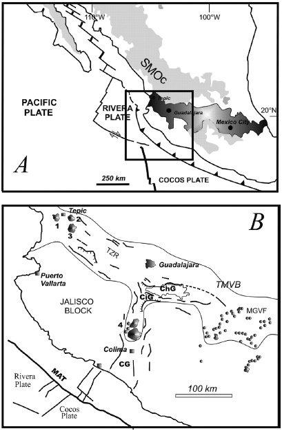
Figure 1 A: Tectonics and volcanics of Mexico. Dark region is the TMVB; SMOc is the Sierra Madre Occidental. Main tectonic structures are indicated. B: Volcanic features other than the Michoacan-Guanajuato Volcanic Field (MGVF) are: 1) San Juan Volcano; 2) Las Navajas volcano; 3) Sangangüey volcano; 4) Colima Volcanic Complex. TZR -Tepic-Zacoalco Rift; MAT Middle America Trench; ChG Chapala Lake; CiG Citala Graben; CG - Colima Graben.
These structures act as a limit between the Sierra Madre Occidental (SMOc), made of middle Tertiary volcanic rocks (located to the north), the Mesozoic Michoacan and Jalisco Blocks (MB and JB, respectively) (located to the south), and in between the TMVB (Johnson and Harrison, 1989; DeMets and Stein, 1990; Allan et al., 1991; Rosas-Elguera et al., 1996; Campos-Enríquez and Alatorre-Zamora, 1998). Several studies report these tectonic systems as currently active (Allan et al., 1991; Delgado, 1992a; Michaud et al., 1994; Moore et al., 1994; Urrutia-Fucugauchi and Rosas-Elguera, 1994; Campos-Enríquez and Alatorre-Zamora, 1998), with some seismic events occurring recently (Pacheco et al., 1999), representing a risk factor, even if these seismic events have occurred in the NE extreme of the JB. Seismic investigations indicated the need to understand the crustal structure for the area (Pacheco et al., 1999), in order to have reliable understanding of the tectonic evolution of western Mexico.
The Tepic-Zacoalco rift (TZR) is constituted by a group of NNW en-echelon depressions with some lateral displacements (Demant, 1981; Luhr et al., 1985; Barrier et al., 1990; Allan et al., 1991; Rosas-Elguera et al., 1997; Campos-Enríquez and Alatorre-Zamora, 1998), with a longitude of more than 200 km (Figure 1) (Luhr and Carmichael, 1990). The Colima rift forms the eastern boundary of the JB, separating it from the Michoacan Block. Some studies extend this rift offshore, in the so-called Manzanillo Trough (Bandy et al., 1995). In its early stages of extensional tectonic evolution, the Colima rift could have been related to the Rivera subduction zone in the Middle America Trench (MAT, Nixon, 1982) (Figure 1).
Gastil et al. (1979) and Ferrari (1995) suggested that late Miocene volcanism represent the product of an important tectonic event related to the opening of the Gulf of California. Ferrari (1995) explained this volcanism in the Guadalajara region due to the WNW motion of the JB in a right-lateral transtensional zone along the boundary between the North American Plate and the JB. This WNW motion could have originated the TZR.
Studies reporting the structure of the Chapala depression are unknown. Geophysical studies have addressed the Colima rift, from its southern portion (Serpa et al., 1992; Urrutia- Fucugauchi and Molina-Garza, 1992; Bandy et al., 1993, 1995) to its central and northernmost parts (Allan, 1985; Campos-Enríquez et al., 1990). A gravity study made in the triple point junction area indicated the approximately depth of the basement west of the Chapala graben, and indicated sediments 800 meters thick in the Citala graben (Campos-Enríquez and Alatorre-Zamora, 1998).
The Chapala Lake is located at a wide depression that has evolved since late Miocene time (Rosas-Elguera and Urrutia-Fucugauchi, 1998); it has a length of 100 km after Luhr and Carmichael (1990), 115 km according to Rosas-Elguera and Urrutia-Fucugauchi (1998). The Pajacuaran (to the south) and the Ixtlan faults (to the north) (Figure 2) bound the eastward continuation of the Chapala depression (Figure 2) (Rosas-Elguera and Urrutia-Fucugauchi, 1998; Pacheco et al., 1999). Its total length would then amount to almost 270 km.

Figure 2 Geology of the study area. Guadalajara urban area is showed to the NW. Other villages showed with small closed black boxes and abbreviations are: SnJC - San Juan Cosalá; Ch - Chapala Village; Ch is also the magnetic base station location; TelA - Tizapán el Alto; CBA - Concepción de los Buenos Aires; T - Tuxcueca town; J - Jocotepec; M - Mezcala town; CdC - Callejón de Calera; LP - La Palma; Aj - Ajijic; ES - El Sauz; SCZ - San Cristobal Zapotitlán. ZHG - Zacoalco Half-Graben; AHG - Amacueca Half-Graben; CG - Citala Graben. Pe enclosed in a circle is the PEMEX exploratory oil well location. A and B are sampling points from Rosas-Elguera and Urrutia-Fucugauchi (1998). Crossing from south to north the modeled profiles are indicated. 1 and 2 indicate the Los Alacranes and Mezcala Islands, respectively (Modified from Rosas-Elguera and Urrutia-Fucugauchi, 1998).
Other authors consider a 400 km extension along the Chapala-Tula fault zone (Pacheco et al., 1999). Some studies have considered that the Chapala graben is in (or is part of) a large rift system along with the Citala graben (Delgado and Urrutia, 1985; Delgado, 1992a; Michaud et al., 1994). Mendoza-Cervantes et al. (2002) modeled a gravity profile across the Citala graben, showing possible crustal thinning in its central part. However, the complete inner structure and the crustal structure of the Chapala graben have not been established yet. A study of landward deformation could be relevant for a better definition of the Rivera-North America boundary (DeMets and Stein, 1990). In this work we analyzed five NS magnetic profiles that were modeled to define the shallow structure of the Chapala depression, constituting a contribution for future seismic and risk studies. We use palaeomagnetic and stratigraphic information to support the magnetic models to avoid (or to decrease) their nonuniqueness and ambiguity.
As no formal study of the structure of the Chapala depression has been reported, most authors consider it in general terms as a graben (or more generally to as a rift). The knowledge of its structure is important because it provides information about the extension mechanisms operating during its formation (i.e., pure shear, or normal shear). This study was undertaken to infer the shallow crustal structure beneath the Chapala Lake. This lake is the major lake in Mexico, and is located 30 k to the southeast of Guadalajara City, at almost 1,527 meters above sea level.
Geologic setting
The oldest rocks around the Chapala Lake are basalts belonging to the Oligocenic SMOc, that are exposed at the NE-corner of the study area, about 30 km southwest of Atotonilco Village (site indicated with "A" in a circle in Figure 2) (Rosas-Elguera and Urrutia-Fucugauchi, 1998). At this site a sequence of basaltic lava flows interlayered with rhyolite and an ash-flow tuff is observed. Seven samples of these basalts and rhyolites were dated by the K-Ar method (Rosas-Elguera and Urrutia-Fucugauchi, 1998). The oldest unit yielded an isotopic age range from 13.5 to 10.8 Ma. This unit is a 400 m thick succession of basalts which overlays the SMOc ignimbrites. Several basaltic dikes trending 57° cut the basalts (Rosas-Elguera and Urrutia-Fucugauchi, 1998). An ash-flow tuff with reworked material and lacustrine sediments at its bottom overlay the basalts. A sample of the bottom of the ash-flow tuff yielded an age of 10.3 Ma.
Most common rocks are those related to the Plio-Quaternary TMVB that include basaltic breccias and basaltic andesites exposed also towards the Rio Grande de Santiago Canyon NE portion (Campos-Enriquez and Alatorre Zamora, 1998). At the Chapala rift, together with other volcanic products, these rocks are referred as the Chapala Breccias (Garduño et al., 1993; Rosas-Elguera and Urrutia-Fucugauchi, 1998), comprising a succession of 500 m of volcanic breccias exposed along a fault plane dipping to the south, at the northern shore of the Chapala Lake. The absolute age of this unit is unknown but to the west of the Chapala village an andesitic lava flow dated at 3.4 Ma KAr rests on the volcanic breccias (Rosas-Elguera and Urrutia-Fucugauchi, 1998). The thickness of these breccias is uncertain, but an exploratory oil well (which location is indicated with "Pe" in a circle in the Figure 2) drilled by PEMEX, found 500 m of Pliocene basalts and andesites, after which it cut 1,848 m of volcanic breccias and agglomerates with scarce intercalated lava flows (López-Ramos, 1979). These thicknesses suggest 1,000 m of vertical offset for post3.4 Ma breccias (Rosas-Elguera and Urrutia-Fucugauchi, 1998).
Possibly the first geologic study in the Chapala area was made by Palmer (1926), who described two basalts in the Chapala depression. The older Tizapan basalt (Palmer, 1926) is exposed on the southern edge of the lake (Figure 2). This basalt was considered Tertiary (possibly Miocene) in age. Palmer (1926) reported that lacustrine beds rest on the Tizapan basalt and that these beds are overlain by the Pleistocene Estancia basalt at Concepción de los Buenos Aires (Figure 2), near Las Caleras (Palmer, 1926).
Although most of the surroundings of the Chapala depression are dominated by volcanic features, lacustrine sediments are widespread. Palmer (1926) referred to the sediments as the Chapala beds, basing the name on the extensive exposures around the town of Chapala on the northern shore of the present lake. Within this designation he includes the beds at Chapala and elevated lake and swamp deposits at Tizapan, Callejon de Calera and La Palma, along the southern of the lake, and at Concepcion de los Buenos Aires, c. 40 km south of the lake (Figure 2). The beds near Chapala town were described as slightly consolidated, very light-gray and white clays, marls and fine sands, together with an occasional bed of coarse sandstone and fine arkose conglomerate (Palmer, 1926). There are also extensive beds of white, diatomaceous earth. In this locality the section is several hundred meters thick, and has a 20 degrees general dip to the northeast. There is no consistent trend in clast size from the bottom to top of the deposits, but volcanic ash is more common in the upper part of the section.
Downs (1958) referred to these beds as the Chapala Formation, and Clements (1962) expanded the definition to include lacustrine sediments which outcrop on the Chapala - Guadalajara highway, north of the volcanic ridge which forms the present northern limit of the Chapala depression. Palmer (1926) reported the presence of fluvial sediments at the western edge of Chapala Lake. The site, denominated as Jocotepec Quarry by Smith (1980), is a sand and gravel pit about 5 km W of the town of Jocotepec (Figure 2). Both Palmer (1926) and Clements (1962) referred to deposits of tuff and pumice in their descriptions of the Chapala Formation, thereby including deposits of fluviatile sediments at Jocotepec Quarry (Smith, 1980). Clements (1962) described a thick conglomerate overlain by ash and pumice north of the lake. His description matches the upper exposures at Jocotepec Quarry.
The Chapala Formation is composed of dipping lacustrine beds exposed about 4 km N of the town of Chapala. The beds have yielded a variety of vertebrate remains (Downs, 1958) including mammals which indicate an Early Pleistocene or Late Pliocene age. Rosas-Elguera and Urrutia-Fucugauchi (1998) redefined the Chapala Formation as an N-NE tilted succession composed of an alternation of lacustrine sediments and pyroclastic units (ash and pumice), which are exposed at western and central portions of the northern lakeshore (Figure 2).
Around the Chapala depression and Chapala lakeshore a rock succession of highly varying composition occurs, being the older basaltic-andesites, calc-alkaline, and alkaline rocks dated between 6.2 to 3.5 Ma (late Miocene-early Pliocene) (Rosas-Elguera et al., 1997). Delgado Granados (1992) grouped these volcanic rocks with the volcano-sedimentary deposits of the Chapala Formation (Downs, 1958; Clements, 1962) and he defined them as the Chapala Group. Rosas-Elguera et al. (1997) designated as Chapala Group a volcanic succession intercalated with some lacustrine deposits.
Delgado-Granados et al. (1995) reported a K-Ar age of 2.5 Ma for a volcano, at the northeastern corner of the Chapala Lake (site indicated with a "B" in a circle in Figure 2), which is correlative with the upper portion of the volcanosedimentary sequence. Thus, the age of the Chapala Formation is bracketed between 3.5 and 2.5 Ma, and consists of almost NEtilted volcanosedimentary blocks.
During late Pliocene, shield and lava cones were emplaced, mainly at the southwestern and northwestern sectors of the Chapala depression (Figure 2). These volcanoes are basically composed of basaltic lavas with calc-alkaline affinity (Rosas-Elguera et al., 1989; Delgado-Granados, 1992), whose products, which were erupted between 3.3 and 2.5 Ma, are denominated as Crucero-Ixtlán basalts (Rosas-Elguera et al., 1997). At the western side, the Crucero-Ixtlan basalts overlain the Chapala breccias and underlain the Chapala Formation, but at the northeastern side, they rest on lacustrine sediments (Figure 2) (Rosas-Elguera et al., 1989). During this Pliocene volcanic activity, the deformation was transferred to the south and concentrated along the southern flank of the Chapala depression (Rosas-Elguera and Urrutia-Fucugauchi, 1998). The Citala graben (Delgado and Urrutia, 1985) then developed in the western axial zone.
The Quaternary is represented by widespread monogenetic volcanoes and particular volcanic fields. One of these is the Acatlan volcanic field, located to the north of the Zacoalco-half graben (Figure 2). This volcanic field is composed of several calc-alkaline rhyolitic-dacitic domes and andesitic cones and lava flows younger than 1.0 Ma (Rosas-Elguera et al., 1997).
The oldest Quaternary rocks of the Acatlan volcanic field are dacitic domes dated in 1.07 Ma (Delgado-Granados, 1992), which rest on the basalts of the Chapala group (Figure 2); at that time a cinder cone and associated lava flow (0.99 Ma, Venegas and Ruy, 1981) were emplaced along the main fault plane (Figure 2) indicating that the Zacoalco half graben was completely developed by this time. The Acatlán Volcanic Field is also the source of the widely known Acatlán Ignimbrite, which show evidence of mingling between a silicic and an andesitic magma (Wright and Walker, 1981; Branney and Kokellar, 2002).
Structures and tectonics
According to Garduño-Monroy et al. (1993) the Chapala tectonic depression is an aulacogen and belongs to an intra-arc regional graben and half-graben system that extend roughly EW across central Mexico, along the Trans-Mexican Volcanic Belt (TMVB) (Figure 1). This graben and horst system has been considered as a regional structure, referred to as the Chapala Tula fault zone (Johnson and Harrison, 1990). Regional tectonic stress patterns have evolved during late Cenozoic, and have changed from dominant left-lateral strike-slip to normal faulting (e.g., Pasquaré el al., 1988; Johnson and Harrison, 1990; Garduño-Monroy et al., 1993; Ferrari et al., 1994; Urrutia-Fucugauchi and Rosas-Elguera, 1994).
Southwest of the Chapala Lake is located the Citala graben, which extends eastward from the triple junction zone and narrows within some 30 km (Delgado-Granados and Urrutia-Fucugauchi, 1986). It is characterized by recent faulting and may represent the most active structure in the region (Pacheco et al., 1999).
Other faults characterize the complex Chapala-Citala grabens; especially to the north and eastern parts, are located longer faults named as Pajacuaran and Ixtlan. In these faults are located several thermal manifestations. Along the northern lake border there are three long E-W faults, one of which is Ixtlan Fault. The southern part, by the other way, especially the southwestern part, has several parallel faults oriented westeast, mainly located between Citala and Chapala tectonic depressions. A great deformation would be concentrated here.
Other factors that indicate recent tectonic activity in the Chapala depression are: a) the ~600 m of the lacustrine sequence of Chapala Formation (Delgado-Granados, 1992); b) the 900 to 1,000 m thick volcano-lacustrine sequence (Rosas-Elguera and Urrutia-Fucugauchi, 1998), which is particularly well exposed in the northern sector of the Chapala Lake; c) and the 1,848 m of volcanic breccias and agglomerates with scarce intercalated lava flows (López-Ramos, 1979) cutted by the PEMEX exploratory well that suggest a post 3.4 Ma 1,000 meters vertical offset, as was mentioned in the geology section. Campos Enriquez et al. (1990) also estimated 1,000 meters of normal faulting from spectral analysis of an aeromagnetic profile oriented NNESSW across the Chapala Lake.
Campos-Enríquez et al. (1990) analyzed the shallow crustal structure in the southern Zacoalco halfgraben and along the Chapala Tula fault zone suggesting a series of large tilted blocks supporting the structural interpretation of the Zacoalco depression as a half-graben.
Rosas-Elguera and Urrutia-Fucugauchi (1998) postulated that the extensional tectonics took over and migrated progressively to the south, to form the present tectonic depression during the past 3.4 Ma.
Data acquisition and processing
Magnetic survey
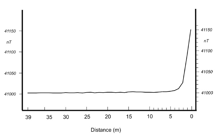
We conducted a marine magnetic survey in 2006 using a precession proton magnetometer G856 from Geometrics with a precision of 0.01 nT, mounted on a fiber glass boat (Figure 3). The periods were March 15, 16, and 23, and April 1. The survey comprised five roughly north-south lines (Figure 2) with measurements every 200 m approximately. The diurnal variation was monitored using a similar precession proton magnetometer in a base station settled to the south of the Chapala Village (closed black square with Ch in Figure 2), where cultural magnetic noise was avoided. Additional measurements obtained on a road, with distances between stations of almost 200 m and measuring 50 meters away from the transporting vehicle to avoid its magnetic noise (Slater and Jacyna, 2012), extended profile AA' 4 km to the south. To obtain the total magnetic field anomaly, the D2010 International Geomagnetic Reference Field was removed. The coordinates of stations, both on land and in water, were controlled with a GPS navigator with a horizontal precision of 1 m. The measurements in the lake water body were obtained mainly in the first day half, when the windy conditions were minimum or scarce. Corrections due to the boat motor magnetic effect were not necessary, because of the measurements were performed with the engine off. Besides, the distance engine magnetometer and the intrinsic materials of the engine (mainly cover, pistons, and propeller made of aluminum) do not give rise to an important magnetic effect. Nevertheless, we made several proofs to measure the magnetic motor effect. The maximum effect disappears at 4 m from the motor (see ADDENDUM).
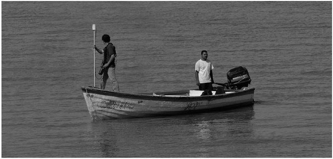
Figure 3 Surveying with the G856 precession proton magnetometer placed in the bow of a fiberglass boat.
The data acquired during the survey showed that the magnetic conditions were stable (or do not seem to show unstable magnetic conditions). This was verified by consulting records of solar flares and magnetic storms for the time periods of data measurements (Christian, 2008; AEG, 2015). There were neither magnetic storms nor solar flares at those periods. Magnetic measurements in Chapala Village base station to control diurnal variation also confirm this last statement (Figure 4).
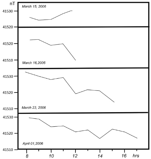
Figure 4 Base station magnetic data measured each hour to control the diurnal variation. This base station is located to the south of the Chapala Village (indicated with a small closed box and the letters Ch in the Figure 2).
The sensor was oriented in each station to the north with the help of a Brunton compass.
Models obtained with Talwani's technique
The modeling was made with the GMSYS magnetic software that applies Talwani's classic method (Talwani, 1965). To constrain our models we taken magnetic susceptibilies and magnetizations from literature, and own palaeomagnetic data. Table 1 shows data used for the rock bodies in the models.
Results and discussion
Magnetic anomalies
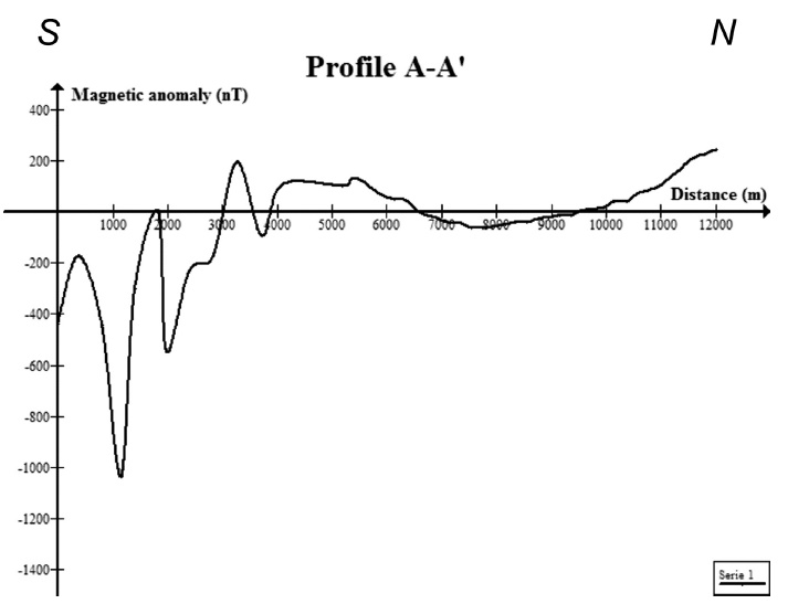
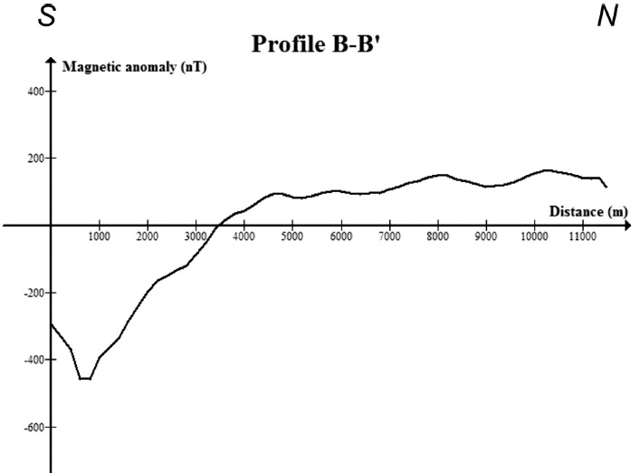
Along the south-to-north profiles the magnetic anomaly behavior changes from west to east across the Chapala Lake. Conspicuous high amplitude small-scale magnetic anomalies are associated with the basaltic andesites that outcrops along the southernmost 4 km of the profile A-A', and to the Mezcala and los Alacranes basaltic Island (profiles C-C' and D-D') (Figures 5c, 5d, and 5a, respectively). Profile B-B' is smooth over a major portion (Figure 5b). Profile E-E' has small-scale anomalies mounted on a regional component (Figure 5e).
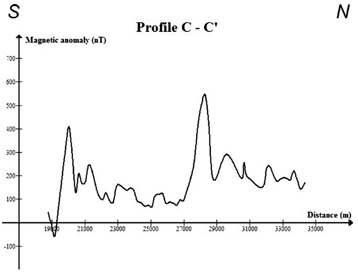
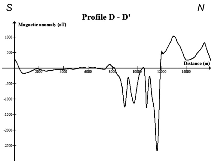
Several major features appear in the magnetic anomalies across the Chapala Lake. From west to east these are: a) large smooth anomalies dominate at the northwestern part of the lake; b) small-scale-high-amplitude anomalies are associated with basaltic flows of Los Alacranes and Mezcala Islands (Figures 5c and 5d). The Los Alacranes Island is associated with a positive anomaly (profile C-C') whereas the anomaly in Mezcala Island (profile D-D') is totally negative.
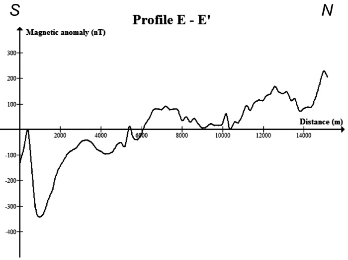
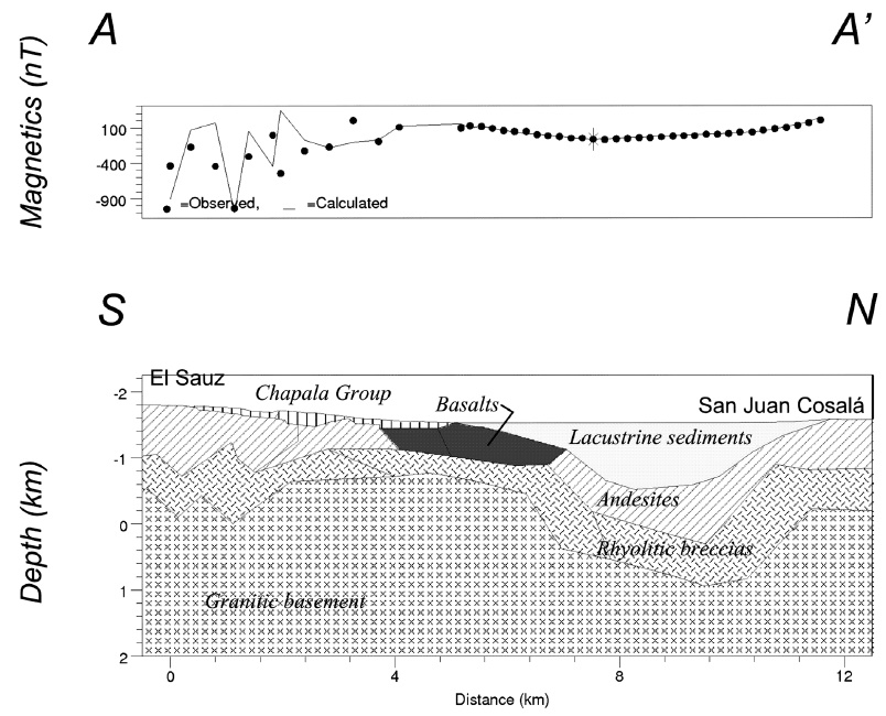
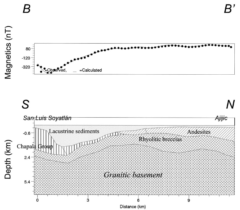
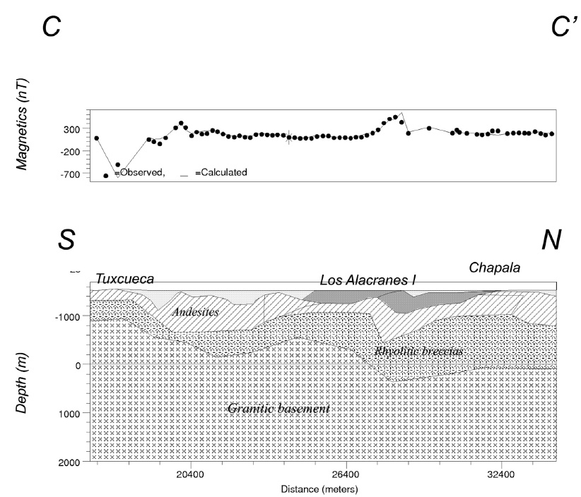
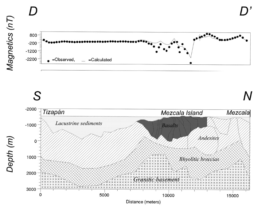
In particular, we observe that: a) profile A-A' shows amplitude near to 300 nT, with a minimum of approximately -100 nT inside the Lake (Figure 5a). This profile includes approximately 4 km of measurements on land along a road, over outcropping basaltic rocks. These small scale anomalies are of local character since they are not observed in the contiguous profile B-B'; b) profile B-B' is composed of a large amplitude negative anomaly to the south and a large amplitude positive anomaly to the north. The total amplitude change is about 500 nT (Figure 5b); c) Profile C-C', that crosses the Los Alacranes Island, is basically high frequency in nature, with an amplitude of 500 nT as well (Figure 5c); d) Profile D-D' shows the largest amplitude, with a minimum near to 2500 nT and a maximum near to 1000 nT, for a total amplitude of 3500 nT; this is due to the basaltic spill of the Mezcala Island (Figure 5d); e) Profile E-E' is similar to profile B-B', with a negative anomaly at its southern portion (Figure 5e).
Modeled profiles
Traditionally normal faults have been considered as straight structures; however, seismic evidences do not support this idea.
At present it is evident that straight faults are relatively rare. Listric faulting and rotated faults associated with systems of tilted blocks are more common. The rotation of blocks in extensional areas requires either a curved fault or substantial internal deformation of the hanging wall block (Wernicke and Burchfiel, 1982). Scale-experiments has shown that ratio between rates of sedimentation and deformation lead fault curvature, thus listric faulting could be explained by combination of domino-sedimentation processes, initial curvature, progressive compaction, and deformation of the fault plane due to salt or shale diapirism (Vandeville and Cobbold, 1988). However, domino-sedimentation processes needs a plastic bed or internal deformation at gaps detachment. Because plastic beds or internal deformation could be absent in Chapala area, modeling assumes that fault shapes are listric in nature.
In general, all models present a similar stratigraphy, with four layers and some local basaltic flows and bodies. The basement is formed of Cretaceous granite (Michoacan Block), covered by SMOc rhyolitic breccias (Miocene-Oligocene), TMVB basaltic andesites (Pliocene) and lacustrine sediments (Quaternary). Susceptibilities and magnetizations used for each body were taken from the literature and other palaeomagnetic studies (Campos-Enríquez et al., 1990; Rosas-Elguera and Urrutia-Fucugauchi, 1998) (Table 1). The thicknesses for all the geologic units, except for the granitic basement, were obtained from the PEMEX exploratory well (Figure 2), and considered for all the models. In almost all cases lateral variability of susceptibilities was considered, mainly for the rocks of the SMOc and the TMVB. Models obtained from these five profiles are described below:
Model A-A'. The magnetic model runs from El Sauz town, in the south, crossing San Cristobal Zapotitlán in the southern shorelake, through the lake western portion, up to the San Juan Cosalá town (Figure 6). A symmetric depression is observed in the centre of the model. The structure of this modeled section approaches a symmetric graben type structure. The volcanosedimentary infill has a thickness of almost 1,200 meters, coincident with results in other studies (e.g., Campos Enriquez et al., 1990). To the south, on the profile land part, faulted basalts of the Chapala Group rest directly on rhyolitic breccias. These basalts might have been emplaced through the southern depression master fault. Faults downward displace the granitic basement. The upper granitic crust on the southern side is shallower than in the northwest (Figure 6).
Model B-B'. This model starts at San Luis Soyatlán at the southern shore ending at Ajijic in the north shore (Figure 7). The model shows a clearly asymmetric depression, with a depocenter located to the south. This depression is offset some 6 km to south with respect to that of the previous model. The basement has a very gentle slope in the northern model portion, and then a slope break marks the beginning of a listric fault featuring the southern depression filled with SMOc rhyolitic breccias, with the Chapala Group basaltic rocks and with approximately 2.2 km of sediments. The model shows an average thickness of 800 m of lacustrine sediments along the northern portion. The granitic basement is located about 4,500 m beneath the sea level. The northern master fault changes in attitude (i.e., in dip).
Model C-C'. This profile crosses the lake from Tuxcueca at the southern shore, to Chapala Village in the north, and includes the basaltic Los Alacranes Island (Figure 8). The existence of a graben or half-graben type structure is not so clear. A relative structural high is observed beneath Los Alacranes Island. To the north and south of this structural high there are two shallow depressions. The sediment infill in the northern depression is very thin. Contrastingly, the thickness of the SMOc rhyolites is larger pointing to the existence of a paleo-depression. The lacustrine Quaternary deposits in the southern depression reaches 400 meters in average. The basalts forming the Los Alacranes Island might be emplaced through the northern fault delimiting this structural high. The granitic basement deepens northwards.
Model D-D'. This magnetic model stretches from Tizapán el Alto, to the south, up to the Mezcala Village to the north (Figure 9). It cuts, in the middle part, the basalts of the Mezcala Island. This model is featured by a structural high (to the north) and a large depression (to the south). The lacustrine sediments reach a thickness of almost 1100 m. The structural high is decomposed into two relative structural highs, being clearer in the granitic basement: one in the centre of the model and the other one in the northern part. The northdipping fault delimiting to the north the central structural high might have controlled the emplacement of the Mezcala Island basaltic spill. The dip of this fault is subvertical (Figure 9) and contrasts with the subhorizontal attitude in the previous and following profiles (i.e., south of the los Alacranes Island; Figures 8 and 10).
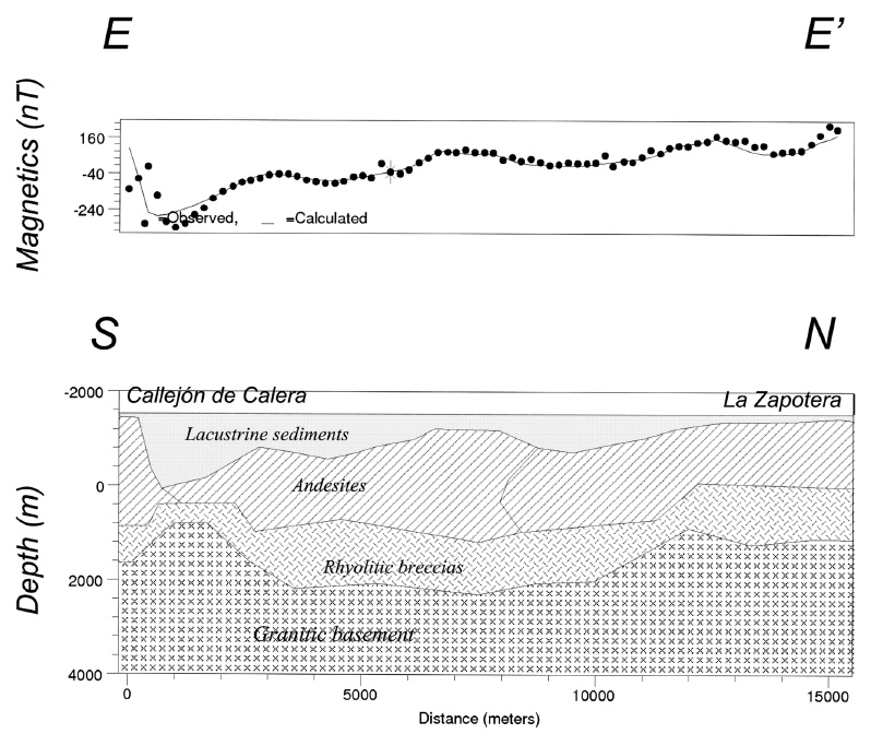
Model E-E'. The easternmost profile crosses the water body from Callejón de Calera at the southern lake limit to La Zapotera, at the northern shore (Figure 10). The model approaches a halfgraben, with the major depocenter to the south. The lake bottom deeps southwards. However, its topography is not even. Two slight depressions are observed along the lake bottom: one near to the north of the major depression, and a second one being the northernmost of the model (Figure 10). These small depressions indicate the presence of faults. Basaltic andesites and rhyolitic breccias fill this depression. The lacustrine sedimentary thickness reaches 400 meters in average. An andesitic deposit fills the depression along all the profile; therefore, the depression is older than the andesitic volcanic emission.
Interpretation of modeled profiles
The five models show differences in structural style. According to the models the Chapala lake depression is complex (Figure 11). There is a depression which is not continuous, there are two structural lows separated by a structural high in the middle portion (comprising profiles B-B', C-C', and D-D', i.e., the Los Alacranes and Mezcala islands).
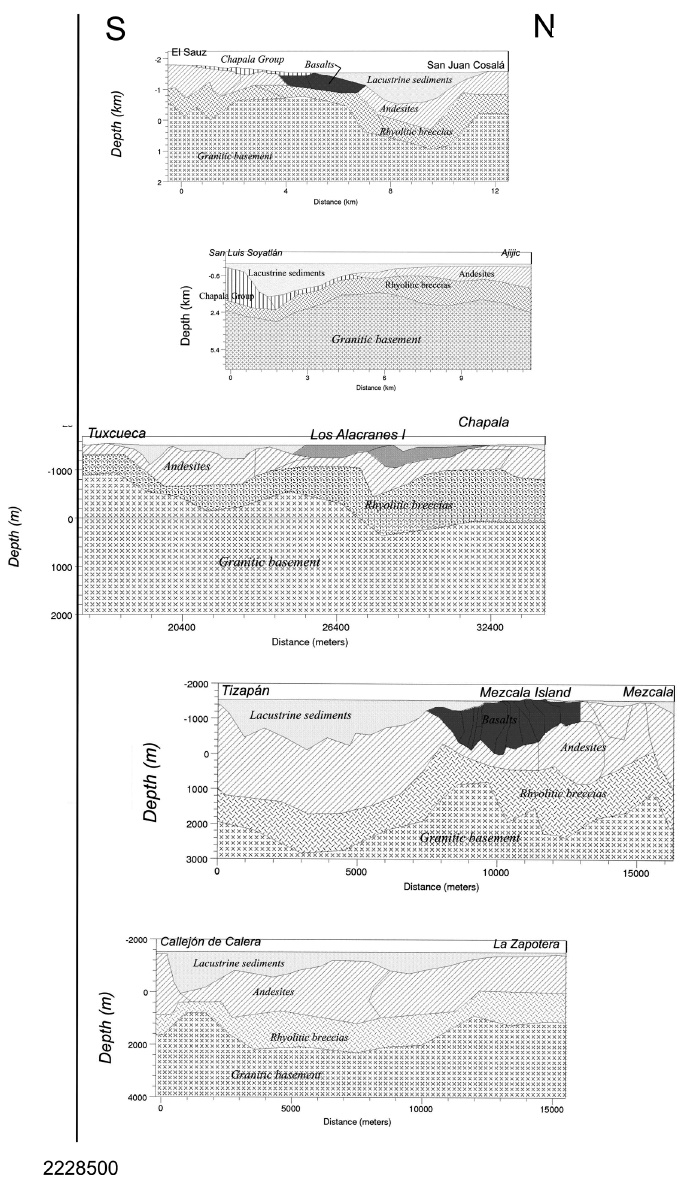
Figure 11 Composite modeled scheme along the Chapala structure. The vertical line corresponds to the 2228500m northing coordinate.
The outlined depression is filled with SMOc and TMVB products. In general, the lacustrine sediments get thicker from east to west.
It is clear that the two depressions do not correspond to a graben type structure but they approximate more to a half-graben type structures. As can be observed in the geologic map, south and north of the middle lake portion, where the structural high was inferred, the faults are not continuous but interrupted.
The depression disappears to the west, where the master faults tend to join together.
It seems that the western portion of the Chapala depression is affected by NWSE faults of the Tepic-Zacoalco rift. The structural high might correspond to an accommodation zone, to the east of which effects of NWSE tectonic system are lesser. Half-graben structures imply that the crust was subject to an extensional tectonics that thins the crust. Campos-Enriquez and Garduño-Monroy (1995) already indicated that western TMVB has a thinned crust.
Conclusions
The models indicate in general a complex structure. In general, listric faults conforms the northwestern shoulder, whereas normal faults constitute its southern limit. These faults are roughly E-W oriented. In detail, the models show at each sector changes of structural types. For example, there is an approximately symmetric graben at the western sector (profile A-A') that changes to a half-graben type structure to the east (profile B-B'), then a structural high (profiles B-B', C-C', and D-D'), and then a wider depression (profiles D-D' and E-E').
The western and eastern depressions are deeper to the south. In the southern part, these depocenters are limited by normal north dipping faults. At its northern limit, the Chapala depression is delimited by north-tilted andesitic blocks. The basaltic lavas of the Los Alacranes and Mezcala Islands might have been emplaced through the faults delimiting the central structural high. The existence of half-graben type structures indicates that the crust was subject to an extensional tectonics.
A deep-seated extension (i.e., Wernicke et al., 1982) that thinned the crust might be at the origin of the half-graben type structures featuring the Chapala depression.