


Servicios Personalizados
Revista
Articulo
 Inglés (pdf)
 Artículo en XML
 Referencias del artículo
 Enviar artículo por email
Indicadores
-
 Citado por SciELO
 -
 Accesos
Links relacionados
-
 Similares en
SciELO
Similares en
SciELO
Compartir

 Permalink
Geofísica internacional
versión On-line ISSN 2954-436Xversión impresa ISSN 0016-7169
Geofís. Intl vol.54 no.1 Ciudad de México ene./mar. 2015
Original paper
Seismicity in the Basin and Range Province of Sonora, México, between 2003 and 2011, near the Rupture of the 3 May 1887 Mw 7.5 Earthquake
Raúl R. Castro
Centro de Investigación Científica y de Educación Superior de Ensenada (CICESE), División Ciencias de la Tierra, Departamento de Sismología, Carretera Ensenada-Tijuana, 3918, 22860 Ensenada, Baja California, México. Corresponding author: raul@cicese.mx
Received: December 12, 2013.
Accepted: April 21, 2014.
Published on line: December 12, 2014.
Resumen
Se estudió sismicidad regional en la Provincia de Cuencas y Cordilleras de Sonora, México, cerca de la región epicentral del sismo del 3 de mayo de 1887 Mw 7.5. Se usaron tiempos de arribo de ondas de cuerpo registradas por la red local RESNES (Red Sísmica del Noreste de Sonora) y dos estaciones de banda ancha regional de la red RESBAN (Red Sismológica de Banda Ancha del Golfo de California) para localizar las fuentes sísmicas originadas entre 2008 y 2011. Primero, se determinaron coordenadas hipocentrales preliminares con el programa Hypoinverse (Klein, 2002) y entonces las coordenadas iniciales fueron determinadas con el método de corrección por estación de fuente específica (Lin and Shearer, 2005). Este procedimiento fue usado en un estudio previo (Castro et al., 2010) para localizar sismos originados en la misma región entre 2003 y 2011. La mayoría de los eventos relocalizados se agrupan cerca de las fallas que rompieron durante el sismo de 1887. Adicionalmente, se documenta la sismicidad a lo largo de las fallas normales de la Provincia de Cuencas y Cordilleras al sur de la ruptura de 1887, tales como las fallas Villa Hidalgo y Granados, y las fallas que confinan la cuenca de Bacadéhuachi. La región del centro poblacional más grande, Hermosillo, parece estar sísmicamente quieta. Esta observación es apoyada por la ausencia de sísmos en el catálogo del Centro Sismológico Internacional (ISC) o sismicidad histórica documentada en esta área.
Palabras clave: sismicidad en Sonora, sismo de Sonora de 1887, provincia de Cuencas y Coordilleras.
Abstract
The regional seismicity in the Basin and Range Province of Sonora, México, near the epicentral region of the 3 May 1887 Mw 7.5 earthquake was studied. Body wave arrival times recorded by the local network RESNES (Red Sísmica del Noreste de Sonora) and two regional broadband stations of the RESBAN (Red Sismológica de Banda Ancha del Golfo de California) network were used to locate the seismic sources originating between 2008 and 2011. Preliminary hypocenter coordinates were first determined with the program Hypoinverse (Klein, 2002) and then relocated the initial coordinates with the source-specific station term method (Lin and Shearer, 2005). The same procedure was used in a previous study (Castro et al., 2010) to locate the earthquakes originating in the same region between 2003 and 2007. I also present in this paper a depurated catalog of events recorded from 2003 to 2011. Most relocated events cluster near the faults that ruptured during the 1887 earthquake. Additionally, I document seismicity along Basin and Range Province normal faults south of the 1887 rupture, such as the Villa Hidalgo and Granados faults and the faults bounding the Bacadéhuachi basin. The region of the largest population center, Hermosillo, appears to be seismically quiescent. This observation is supported by a lack of entries in the catalog of the International Seismological Centre (ISC) or documented historical seismicity in that area.
Key words: seismicity in Sonora, 1887 Sonora earthquake, Basin and Range province.
Introduction
The tectonic-physiographic province of the southern Basin and Range is characterized by active extension (Yeats, 2012). The 3 May 1887 Mw 7.5 Sonora, Mexico earthquake is the largest historical event in this region (de Polo et al., 1991; Yeats et al., 1997), in which an array of three north-south striking, west-dipping normal faults (Pitáycachi, Teras and Otates, Figure 1) slipped sequentially along the western edge of the Sierra Madre Occidental plateau. The documented surface rupture has a length of 101.8 km and a maximum structural displacement of 5.2 m (Suter and Contreras, 2002; Suter, 2008a, 2008b).
The major purpose of this study is to constrain areas of active faulting in northeastern Sonora, specifically in the epicentral region of the 1887 earthquake. In 2002, the Centro de Investigación Científica y de Educación Superior de Ensenada (CICESE), in collaboration with the Instituto de Geología, Universidad Nacional Autónoma de México (UNAM), installed for that reason Red Sísmica del Noreste de Sonora (RESNES), a seismic network surrounding the surface rupture of the 1887 earthquake. The data recorded by RESNES from 2003 to 2007 were presented by Castro et al. (2010). Here, we add the recordings from 2008 until 2011, when the monitoring was discontinued and the network was dismantled. Additionally, we present in this paper a depurated catalog of the events recorded by RESNES during the entire existence of the network between 2003 and 2011.
Previous studies
The 1887 Sonora earthquake has generated a long-lasting, still ongoing, and well documented aftershock sequence, as summarized in Castro et al., (2010). Based on felt reports and observations with an improvised seismoscope, Goodfellow (1888) and Aguilera (1888) located aftershocks in the stepover between the Pitáycachi and Teras, and Vazquez (1887) in the region of the Otates rupture segments (Figure 1). The seismicity catalogs by Orozco y Berra (1887, 1888) contain compilations of shocks of the 1887 seismic sequence. A summary of the contemporary studies of the 1887 Sonora earthquake was made by Suter (2006). The 1907 MI 5.2 Colonia Morelos earthquake and the 1913 MI 5.0 and 1923 MI 5.7 earthquakes in the Granados-Huásabas region (Suter, 2001) have also been considered aftershocks of the 1887 event, since the distribution of these aftershocks correlates well with calculated changes in Coulomb failure stress resulting from the 1887 rupture (Suter and Contreras, 2002).
Natali and Sbar (1982) studied the microseismicity in the region of the Pitáycachi fault. They deployed a temporal network of 7–10 portable seismographs that operated between 1978 and 1979. They located small earthquakes, with magnitudes M< 2, to the west of the Pitáycachi fault trace and farther south, beyond the network, near the Teras and Otates rupture segments.
Wallace et al. (1988) and Wallace and Pearthree (1989) relocated a series of earthquakes that occurred in this region in 1987–1989, the largest one having a magnitude of 4.2. These events together with the 1908 MI 4.8 Fronteras earthquake (Suter, 2001) form a cluster that is likely to have originated on the Teras fault (Suter, 2008b).
Instrumentation and data acquisition
All stations of the RESNES network (Table 1; triangles in Figure 1) are autonomous and consist of Kinemetrics digital recorders (model K2) with an internal triaxial force-balance accelerometer registering three components of ground acceleration and have a built-in Global Positioning System (GPS) timing system. A vertical-component short-period sensor (model L4C) is connected to a fourth recording channel. These stations record local and regional events with a rate of 200 samples per second. Figure 2 shows velocity records from a sample of six earthquakes recorded by three stations (ELO, OAX, and BAC) at different epicentral distances. These well-recorded seismograms show clear P- and S-wave arrivals and a high signal-to-noise ratio for both, local and regional distances.
For events between 2008 and 2011, I started with an initial data set consisting of 504 events (M < 3.6) recorded by at least three stations of the RESNES array and permitting a minimum of five P- and S-wave arrival time readings. For some of these events, particularly those having originated south of the RESNES array, I also used arrival times from stations NE80 and NE81 (Table 1 and Figure 1; located near Caborca and El Novillo dam, respectively) of the RESBAN (Red Sismológica de Banda Ancha del Golfo de California) network. Castro et al. (2010) had located events recorded 2003–2007 by RESNES and by stations of the NARS (Network of Autonomously Recording Seismographs) -Baja array. For events having originated between April and December 2007, they had additionally used arrival times from USArray stations located within 150 km of the United States – Mexico border.
Methodology
The initial epicentral coordinates and the source depth of the 504 events that had originated between 2008 and 2011 were calculated using the Hypoinverse computer code (Klein, 2002) and the P-wave seismic velocity model V1 (Figure 3 and Table 2) obtained by Harder and Keller (2000) from a wide-angle seismic north-south profile in southwestern New Mexico, close to the epicentral region of the 1887 Sonora earthquake. A very similar model was more recently obtained by Averill and Miller (2013) from an east-west seismic refraction/reflection survey along the New Mexico-Chihuahua border. Only events recorded by at least three stations with more than four clear body wave arrivals and (S-P) ≤ 25 sec were located. P and S wave arrival times were handpicked, with an approximate accuracy of one tenth of a second. Then the initial hypocentral locations were added to the nearly 600 local and regional events obtained by Castro et al. (2010) for the period 2003–2007. Figure 1 displays the 1107 epicenters located with Hypoinverse for the period 2003-2011. The smallest magnitude of the earthquakes located is 0.9; although not all the events with M>0.9 were located due to the restrictions described above. Subsequently, I dequarried this 2003–2011 initial catalog by removing daylight events (from 18:00 hrs UT to 06:00 hrs UT) and events with a focal depth shallower than 2 km, resulting a new catalog consisting of 300 earthquakes. To dequarry the initial catalog, event swarms near mines were identified based on the seismicity map reported by Castro et al. (2010). The boxes in Figure 1 delimit the extent of the swarms in the neighborhood of three main mines: Cananea in the northwest, Nacozari in the central part of the network and Mulatos in the southeast. Events inside those boxes that occurred from 18:00 hrs UT to 06:00 hrs UT were discarded.


The 300 remaining hypocenters were relocated using the source-specific station term (SSST) technique (Richards-Dinger and Shearer, 2000). This method consists of selecting events within a sphere of a specified radius (rmax), with the target event being located at the center. With this technique, each station has a station correction function that varies with source position. This location method is useful for northeastern Sonora, where the seismic events cover a large area and where lateral velocity heterogeneities can be expected (Castro et al., 2010).
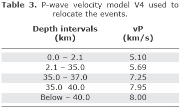
The SSST method was implemented by Lin and Shearer (2005) in their COMPLOC earthquake location code. I relocated the initial dequarried hypocenters, obtained with Hypoinverse, with a modified version of COMPLOC that permits to include regional phases (Pn, Pg, Sn, Sg) and weights the phase arrival picks according to the source-station distance. For this relocation I used the same procedure and velocity models (V2 and V4 in Figure 3) as Castro et al. (2010). These velocity models give smaller travel-time residuals than other velocity models tested by Castro et al. (2010). Models V2 (Table 2) and V4 (Table 3) consist of three and four layers, respectively, with small gradients to make the change of velocity with depth gradual. The P-wave velocity of the shallowest layer is 5.1 km/s, like in the V1 model by Harder and Keller (2000), and 7.95 km/s at the base of the crust (Tables 2 and 3). We divided the region into five rectangles, shown on Figure 4, to minimize regional variations of the velocity structure. One of the rectangles, northwest of the RESNES array, covers the area near Cananea; three rectangles cover the fault segments that ruptured in 1887; and the last rectangle, located in the southeast, covers the plateau of the Sierra Madre Occidental.
The catalog of relocated events was filtered again using the same spatial criteria as before, relocated events near the mines (inside boxes in Figure 1) that occurred from 18:00 hrs UT to 06:00 hrs UT were discarded and only the best relocated events (rms< 1 sec) were kept for further analysis.
Results
Figure 4 shows the best relocated epicenters (with rms< 1 sec) obtained using model V2 and having originated between 2003 and 2011, the fault segments that ruptured during 1887, and the locations of the stations of the RESNES array. To assure that other random quarries were not included, relocated events with focal depths shallower than 2 km were also eliminated. Two groups of earthquakes can be identified: a first group on the western margin of the Sierra Madre Occidental, along the fault segments that ruptured in 1887; and a second group near the southern end of the RESNES array, east of Bacadéhuachi (BAC). Castro et al. (2010) had located an additional group of events in the Sierra Madre Occidental, near the Mulatos, Sonora gold mine (southeasternmost rectangle on Fig. 1), and near Cananea and Nacozari mines. However, the origin times of these events are within the time window and or focal depths used to eliminate quarry blasts from the data set. Most of the events in the Mulatos, Nacozari and Cananea regions are likely to be mining-related; consequently, they were not include in this study.
Figure 5 shows the focal depth distributions of the original locations obtained with Hypoinverse (top row) and of the events relocated with velocity models V2 (bottom row) and V4 (middle row). The hypocenters are projected onto an east-west section (left column) and onto a north-south section (central column). The relocated events show significantly less scatter than the original locations. The seismicity shows well-defined subvertical alignments reaching a depth of 40 km, which are interpreted below. Comparing the initial locations made with Hypoinverse (Figure 5 top row) with those relocated with the SSST algorithm (middle and bottom rows in Figure 5) one can see that events initially located outside of the network (near 1120W and 28.50N) were eliminated for being poor located events (rms> 1.0 sec). These events are difficult to relocate with the SSST method because they are sparse and there are not enough events in their vicinity to calculate an adequate station correction term.
In the right column of Figure 5, the focal depths are grouped in 5-km bins. The depths obtained with the SSST method and model V4 (middle row) show two maxima, one at shallow depths (0-15 km), with 60.6% of the events, and another one near the base of the crust (35-40 km), with 12.8% of the events. On the other hand, most of the foci (84%) located with Hypoinverse have shallow depths (0-15 km). The events relocated with model V2 are all above 30 km, 52% concentrate between 5-15 km, 37% between 15-30 km and the rest (11%) above 5 km. Although the velocity models V2 and V4 give both low residuals compared with other velocity models tested by Castro et al. (2010), the focal depth distribution obtained here with model V2 is more realistic, since all the events are located above the base of the crust and most of them (63%) have shallow depths (above 15 km), as observed in other regions of the Basin and Range province (e.g. Gomberg, 1991). Thus, model V2 is the preferred velocity model used in the next section to interpret the regional seismicity shown in Figures 4 and 6.
Seismotectonic interpretation
The seismicity originating 2003–2011 and relocated with the SSST method are displayed in maps and sections in Figures 1, 4 and 5 (lower row). It shows several clusters and alignments, which are placed here within their neotectonic framework. We also compare the distribution of seismicity of the period 2003–2007 (Castro et al. 2010) with the more recent one during 2008–2011.
As in the period 2003–2007, several microearthquakes of the period 2008–2011 originated to the west and to the south of the segmented 1887 rupture trace (segments Pitáycachi, Teras, and Otates, marked by bold lines and letters P, T, and O, respectively in Figure 6). Four new events originated near and beyond the northern tip of the documented 1887 surface rupture, where additional events were recorded by the Earthscope USArray (Lockridge et al., 2012). Two new events were recorded in 2008–2011 in the stepover between the Pitáycachi and Teras segments, and one additional event west of the Teras segment, but no additional event west of the Otates rupture segment (Figure 6). In the east-west section shown in Figure 5 (bottom row), the recorded microseismicity located along the 1887 rupture trace shows a well-defined subvertical alignment at 109.25° W from the surface to a depth of 30 km.
In addition to the two events documented by Castro et al. (2010), several new events occurred between 2008 and 2011 to the west of the Villa Hidalgo fault (V on Figure 6). Many new events were also recorded in the Bacadéhuachi basin, near station BAC (Figure 6). This basin is bound on its eastern side by several map-scale normal faults (Piguet, 1987; Montigny et al., 1987). Similarly to the microearthquakes recorded along the Villa Hidalgo fault and in the Granados-Huásabas area (Figure 6), these events can be explained by an increase in Coulomb failure stress in this region resulting from the 1887 rupture (Suter and Contreras, 2002). In an alternative interpretation of the microseismicity along these faults, the 1887 rupture may have extended farther south than documented and ruptured one or several of them. However, field checking of the trace of the Villa Hidalgo fault east of Villa Hidalgo did not reveal any obvious morphological or stratigraphic evidence for a recent rupture (Suter, 2013, personal comunication), neither did the detailed structural mapping by Piguet (1987) of the faults between Granados and the plateau of the Sierra Madre Occidental (Figure 6). Nevertheless, these faults should become the target of more detailed, field-based structural and stratigraphic studies to document their activity in the geologically recent past. North of the Bacadéhuachi basin, between stations ARI and HUA, near 109ºW (Figure 6) are three new events (white circles) and one that originated in the 2003-2007 period. These events could be the result of tensional stress that concentrates between the adjacent normal faults, the Villa Hidalgo fault on the west (V in Figure 6) and Otates on the east.
A NNW-SSE oriented epicenter alignment, 70 km long, can be seen on Figure 1, 30–40 km west of Cananea, in north-central Sonora. It is possible that some of these events are caused by mining excavations and the related redistribution of tectonic stress. However, they were removed from the catalog because were originated within the time window scheduled for the mining blasts. Local mapping and compilation of previous mapping by Manuel et al. (2011, plate 2) indicate that the major ranges of this region are bound by normal faults that displace bedrock against Miocene to Holocene sedimentary and volcanic rocks. The Imuris lineament (Figure 1), a major crustal discontinuity (Nourse et al., 1994; Nourse, 1995), passes across the mountain range located to the west of the epicenter alignment, where it is characterized by linear, unembayed regional-scale fault scarps. However, no detailed neotectonic studies exist of this region. Historical earthquakes in the general vicinity of the recorded microseismicity alignment are the 30 March 1916 MMImax VI Nogales and the 16 October 1999 ML 4.5 MMImax VI Magdalena earthquakes (Suter, 2001), as well as an additional 15 June 1897 earthquake felt in the Magdalena area (Boletín Mensual del Observatorio Meteorológico Central de México, 1897, p. 80). Figure 4 shows three events relocated in this area and two reported by the Bulletin of the International Seismological Centre (red circles in Figure 4).
Another major seismicity cluster is observed near Nacozari (station NAC on Figure 1), which is characterized by intense copper mining activity. Since I filtered quarry blasts from the catalog they are absent in the maps of relocated events (Figures 4 and 6), and it is likely that most of these events are mining-related earthquakes, such as mining-induced implosions by rock collapse (Ford et al., 2008; Julià et al., 2009).
Discussion
The seismicity detected by the RESNES array in the period 2008–2011 shows a concentration of events along and southward of the fault segments that ruptured during the 3 May 1887 Mw 7.5 earthquake (Figure 6). This distribution of seismicity enhances the pattern recorded between 2003 and 2007 by the same network (Castro et al., 2010) and can be interpreted as long-lasting aftershock activity taking place in the epicentral area of the 1887 main shock. Large intraplate earthquakes can increase locally the strain energy in the crust and can also increase the Coulomb stress significantly (Li et al., 2007). Changes in Coulomb failure stress resulting from the 1887 earthquake calculated by Suter and Contreras (2002) correlate well with the distribution of events relocated in this study. Stein and Liu (2009) propose that the strain energy release from large intraplate earthquakes may dominate the local strain energy budget for many years following the main shock.
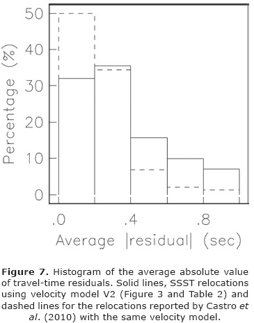
Comparing the errors in location reported by Castro et al. (2010) with those obtained in this study, in term of travel time residuals, Figure 7 shows that 83.2% of the events relocated in this study and 91.1% of the events relocated by Castro et al. (2010) have average residuals of less than 0.5 sec. Although the method (SSST) and the velocity model (V2) used in both studies is the same, Castro et al. (2010) used a larger number of additional stations, from the NARS-Baja and USArray networks. These explain why more events with small average residuals were obtained by Castro et al. (2010).
Based on the parametric catalog of the historical seismicity of northeastern Sonora by Suter (2001) and the seismicity recorded by RESNES during 2003–2007, the region southwest of the RESNES array, near Hermosillo, seems to be seismically inactive (Castro et al., 2010), which is confirmed by the lack of events recorded during 2008–2011. To verify whether this observation is not due to limitations in detection capability of the RESNES network, we searched the Bulletin of the International Seismological Centre (ISC) for earthquakes occurring in our region of interest. Figure 4 (circles filled in red) displays the epicenters reported in the ISC Bulletin from their earliest entry in 1964 to June 2013. Some of the events reported by ISC near Hermosillo are earthquakes caused by motion along faults in the Gulf of California. It is likely that the few events located on the continent are poorly located and actually originated in the Gulf of California. ISC also reports two events southwest of Cananea, next to the Imuris lineament, including the 16 October 1999 ML 4.5 Magdalena earthquake already mentioned previously, and several events near Nacozari. Two of the latter were flagged by the ISC as possible mine blasts, other ones may have been caused by mining excavations and the related redistribution of tectonic stress. Castro et al. (2010) located a larger number of events near Cananea because they eliminated events that occurred only on the schedule provided by the mining company or events having wave forms typical of blasts. In this study all the events within the time window of the blast schedule (from 18:45 hr UT to 04:30 hr UT) were eliminated and the time window was extended 45 min before and 90 min after the schedule in case the blast started before or after the schedule programed.
Conclusions
The microseismicity recorded by the RESNES array during 2003–2011 is mostly located in the epicentral area of the 3 May 1887 Mw 7.5 earthquake, which confirms that this large intraplate event is still generating aftershocks. Most of the relocated earthquakes originated at a crustal depth close to the fault segments that are known to have ruptured in 1887. Additionally, much microseismicity was recorded near the Basin and Range Province faults located to the south of the 1887 rupture, such as the Villa Hidalgo and Granados faults, and the faults bounding the Bacadéhuachi basin. The distribution of seismicity correlates well with numerical models of the changes in Coulomb failure stress resulting from the 1887 earthquake. More knowledge about the past activity of these faults should be gained from field-based geological studies of their structure and Quaternary stratigraphy.
The NNW-SSE oriented alignment of microseismicity located beyond the RESNES network, to the west of Cananea, near the epicenter of the 16 October 1999 ML 4.5 Magdalena earthquake and near a major crustal discontinuity known as the Imuris lineament (Figure 1) is probably caused by mining excavations and the related redistribution of tectonic stress. Similarly, the cluster of microseismicity recorded in the Nacozari region is most likely due to mine tremors induced by rock bursting.
Data and resources
An extensive bibliography related to the 1887 earthquake is posted at www.geo.arizona.edu/gsat/1887eq/bibliography.html. It includes the digitized 1888 report by José Guadalupe Aguilera. The seismograms used in this paper were recorded by stations of the RESNES seismic array. Data from the RESNES network can be requested from the author of this study. Some figures were made using the Generic Mapping Tools (www.soest.hawaii.edu/gmt; Wessel and Smith, 2009). The digital elevation model in Figure 6 was created from SRTM (Shuttle Radar Topography Mission) data with Surfer®9 (www.goldensoftware.com).
Acknowledgments
The installation and operation of the Seismic Network of Northeastern Sonora (RESNES) has been possible thanks to the financial support of the Mexican National Council for Science and Technology (CONACYT) (projects G33102-T and 59216). Carlos Huerta provided logistic support from 2008 to 2012. I am also grateful for the technical assistance given by Luis Inzunza, Antonio Mendoza, Arturo Pérez Vertti and Ignacio Méndez. I am thankful for the participation of César Jacques-Ayala and Oscar Romero (Instituto de Geología, Universidad Nacional Autónoma de México) during the initial part of the project. I am grateful to Max Suter for his useful suggestions and comments during the preparation of the manuscript. The author also thanks the anonymous reviewers, Associate Editor Dr. Xyoli Pérez Campos and Editor-inChief Dr. Cinna Lomnitz, who helped me to improve the manuscript. Elizabeth Morales Hernández provided efficient communication.
References
Aguilera J.G., 1888, Estudio de los fenómenos séismicos del 3 de mayo de 1887. Anales del Ministerio de Fomento de la República Mexicana 10, 5-56. [ Links ]
Averill M.G., Miller K.C., 2013, Upper crustal structure of the southern Rio Grande rift: A composite record of rift and prerift tectonics, in New Perspectives on Rio Grande Rift Basins: From Tectonics to Groundwater, M. R. Hudson, and V. J. S. Grauch (Editors), Geological Society of America Special Paper 494, p. 463–474, doi:10.1130/2013.2494(17). [ Links ]
Castro R.R., Shearer P.M., Astiz L., Suter M., Jacques-Ayala C., Vernon F., 2010, The long-lasting aftershock series of the 3 May 1887 Mw 7.5 Sonora earthquake in the Mexican Basin and Range Province. Bull. Seism. Soc. Am. 100, 1153-1164. [ Links ]
de Polo C.M., Clark D.G., Slemmons D.B., Ramelli A.R., 1991, Historical surface faulting in the Basin-and-Range province, western North America–Implications for fault segmentation. J. Struct. Geol., 13, 123-136. [ Links ]
Ford S.R., Dreger D.S., Walter W.R., 2008, Source Characterization of the 6 August 2007 Crandall Canyon Mine Seismic Event in Central Utah. Seism. Res. Lett., 79, 637-644, doi:10.1785/gssrl.79.5.637. [ Links ]
Gomberg J., 1991, Seismicity and detection/location threshold in the Southern Great Basin Seismic Network. J. Geophys. Res., 96, 16401-16414. [ Links ]
Goodfellow G.E., 1888, The Sonora earthquake. Science 11, 162-166. [ Links ]
Harder S., Keller G.R., 2000, Crustal structure determined from a new wide-angle seismic profile in southwestern New Mexico, in Southwest Passage: a trip through the Phanerozoic, New Mexico Geological Society Guidebook, Fifty-First Annual Field Conference, T. W. Lawton, N. J. McMillan, and V. T. McLemore (Editors), New Mexico Geological Society, Socorro, p. 75-78. [ Links ]
Julià J., Nyblade A.A., Durrheim R., Linzer L., Gök R., Dirks P., Walter W., 2009, Source Mechanisms of Mine-Related Seismicity, Savuka Mine, South Africa. Bull. Seism. Soc. Am., 99, 2801-2814, doi:10.1785/0120080334. [ Links ]
Klein F.W., 2002, User's guide to HYPOINVERSE-2000, a Fortran program to solve for earthquake locations and magnitudes, USGS Open File Report 02-171, 121pp. [ Links ]
Li Q., Liu M., Zhang Q., Sandvol E., 2007, Stress evolution and seismicity in the central-eastern United States: Insights from geodynamic modeling, in Continental Intraplate Earthquakes: Science, Hazard, and Policy Issues, S. Stein, and S. Mazzotti (Editors), Geological Society of America Special Paper 425, 149–166. [ Links ]
Lin G., Shearer P.M., 2005, Test of relative earthquake location techniques using synthetic data. J. Geophys. Res., 110, B04304, doi:10.1029/2004JB003380. [ Links ]
Lockridge J.S., Fouch M.J., Arrowsmith, J. R., 2012, Seismicity within Arizona during the deployment of the EarthScope USArray transportable array. Bull. Seismol. Soc. Am. 102, 1850-1863, doi: 10.1785/0120110297. [ Links ]
Manuel D.J., Lawton T.F., González-León C., Iriondo A., Amato J.M., 2011, Stratigraphy and age of the Upper Jurassic strata in north-central Sonora, Mexico: Southwestern Laurentian record of crustal extension and tectonic transition. Geosphere, 7, 390–414; doi: 10.1130/GES00600.1. [ Links ]
Montigny R., Demant A., Delpretti P., Piguet P., Cochemé J.J., 1987, Chronologie K/Ar des séquences volcaniques tertiaires du nord de la Sierra Madre Occidental (Mexique). Comptes Rendus de l'Académie des Sciences, série II, 304(16), 987-992. [ Links ]
Natali S.G., Sbar M.L., 1982, Seismicity in the epicentral region of the 1887 northeastern Sonora earthquake, Mexico. Bull. Seism. Soc. Am., 72, 181-196. [ Links ]
Nourse J.A., 1995, Jurassic-Cretaceous paleogeography of the Magdalena region, northern Sonora, and its influence on the positioning of Tertiary metamorphic core complexes, in Studies on the Mesozoic of Sonora and adjacent areas, C. Jacques-Ayala, C. M. González-León, and J. Roldán-Quintana (Editors), Geological Society of America Special Paper 301, p. 59–78. [ Links ]
Nourse J.A., Anderson T.A., Silver L.T., 1994, Tertiary metamorphic core complexes in Sonora, northwestern Mexico. Tectonics, 13, 1161-1182. [ Links ]
Orozco y Berra J., 1887, Efemérides séismicas Mexicanas, Memorias de la Sociedad Científica Antonio Alzate 1, 303-541. [ Links ]
Orozco y Berra J., 1888, Efemérides séismicas Mexicanas, adiciones y rectificaciones, Memorias de la Sociedad Científica Antonio Alzate 2, 261-288. [ Links ]
Piguet P., 1987, Contribution à l'étude de la Sierra Madre Occidental (Mexique): La séquence volcanique tertiaire de la transversale Moctezuma – La Norteña: Université de Droit, d'Economie et des Sciences d'Aix-Marseille, Faculté des Sciences et Techniques de St-Jérome, Thèse pour obtenir le grade de Docteur en Sciences, 208 p. [ Links ]
Richards-Dinger K., Shearer P., 2000, Earthquake locations in southern California obtained using source-specific station terms. J. Geophys. Res., 105, 10,939-10,960. [ Links ]
Stein S., Liu M., 2009, Long aftershock sequences within continents and implications for earthquake hazard assessment. Nature, 462, 87-89. [ Links ]
Suter M., 2001, The historical seismicity of northeastern Sonora and northwestern Chihuahua, Mexico (28-32° N, 106-111° W), J. South Am. Earth Sci., 14, 521-532. [ Links ]
Suter M., 2006, Contemporary studies of the 3 May 1887 Mw 7.5 Sonora, Mexico (Basin and Range Province) earthquake. Seism. Res. Lett., 77, 2, 134-147. [ Links ]
Suter M., 2008a, Structural configuration of the Otates fault (southern Basin and Range Province) and its rupture in the 3 May 1887 MW 7.5 Sonora, Mexico, earthquake. Bull. Seism. Soc. Am., 98, 2879-2893. [ Links ]
Suter M., 2008b, Structural configuration of the Teras fault (southern Basin and Range Province) and its rupture in the 3 May 1887 MW 7.5 Sonora, Mexico earthquake. Revista Mexicana de Ciencias Geológicas, 25, 179-195. [ Links ]
Suter M., Contreras J., 2002, Active Tectonics of Northeastern Sonora, Mexico (Southern Basin and Range Province) and the 3 May 1887 MW 7.4 Earthquake. Bull. Seismol. Soc. Am., 92, 581-589. [ Links ]
Vázquez L., 1887, El terremoto del 3 de Mayo, La Constitución, Periódico Oficial del Gobierno del Estado (Hermosillo, Sonora) 9, 24, 1–2. [ Links ]
Wallace T.C., Domitrovic A.M., Pearthree P.A., 1988, Southern Arizona earthquake update. Arizona Geology 18, 4, 6-7. [ Links ]
Wallace T.C., Pearthree P.A., 1989, Recent earthquakes in northern Sonora. Arizona Geology 19, 3, 6-7. [ Links ]
Wessel P., Smith W.H.F., 2009, The Generic Mapping Tools (GMT) version 4.5.0 technical Reference & Cookbook, SOEST/NOAA. [ Links ]
Yeats R.S., Sieh K., Allen C.R., 1997, The geology of earthquakes, Oxford University Press, Oxford, United Kingdom, 568 p. [ Links ]
Yeats R., 2012, Active faults of the World, Cambridge University Press, Cambridge, United Kingdom, 621 p. [ Links ]

