


Serviços Personalizados
Journal
Artigo
 Inglês (pdf)
 Artigo em XML
 Referências do artigo
 Enviar este artigo por email
Indicadores
-
 Citado por SciELO
 -
 Acessos
Links relacionados
-
 Similares em
SciELO
Similares em
SciELO
Compartilhar

 Permalink
Geofísica internacional
versão On-line ISSN 2954-436Xversão impressa ISSN 0016-7169
Geofís. Intl vol.51 no.4 Ciudad de México Out./Dez. 2012
Original paper
Hydrostratigraphy of Haftad Gholle Karst, Markazi province, Iran, optimized by Fuzzy Logic
Mostafa Yousefi Rad*
Department of Geology, Faculty of Earth Sciences Payam Noor University Tehran, Iran. *Corresponding author: mostafa.yousefirad@yahoo.com.
Received: October 05, 2011;
accepted: April 10, 2012;
published on line: September 28, 2012.
Resumen
Este trabajo presenta la litología kárstica de la región de Haftad Gholle en el SE de Arak, Irán empleando el enfoque de lógica borrosa. El área fue dividida en 7 mitades litológicas. El resultado permitió identificar los recursos del agua óptimos en las calizas macizas del Cretácico Inferior.
Palabras clave: Karst, hidroestratigrafía, lógica borrosa, Arak.
Abstract
The objective of this study is to optimize the karstic lithology in the Haftad Gholle area located of South-eastern Arak, NW Iran, using fuzzy logic.The karst of Haftad Gholle area was divided into seven lithologic units; information on effective properties including thickness, RQD (Rock Quality Designation), opening joints, joint distance, porosity, permeability, and bedding were obtained. Using Similarity to Ideal Solution approach, the data were transformed to fuzzy numbers, and the analysis was performed. The results showed that the best karstic water resources correspond to a unit which includes lower massive limestone karstic units (KL1) belonging to the Lower Cretaceous.
Keywords: Karst, Hydrostratigraphy, Fuzzy logic, Arak.
Introduction
A Hydrostratigraphic unit includes all or part of a petrologic set which is separated from other units by hydrogeologic properties (Maxey, 1964).
Seaber (1988) proposed that porosity and permeability are the most important feature in determining a hydrostratigraphic unit, but Van Wagoner (1988) involves other properties such as usual hydrodynamic coefficients in the aquifers to define the properties of a hydrostratigraphic unit. The study area is located 40 km to the southeast of Arak, city in the Markazi province (Figure 1).
Main water resources in the area include Anjadan springs, with a water discharge of about 20 liters per second, and a deep well drilled into the lower Cretaceous with a water discharge of about 10 liters per second.
This study has been done to survey the hydrostratigraphic units belonging to the karstic water resources of Haftad Gholle to the Southeast of Arak in Markazi Province, Iran, The best karstic water resources were determined by the Similarity to Ideal Solution method.
Methodology
Usual methods were used to determine the lithostratigraphy and biostratigraphic properties. A Lugeon test was first performed in seven boreholes drilled in each lithologic unit to determine the permeability and other relevant hydrostratigraphical properties of the lithologic.
All boreholes were sampled to obtain the degree of effective porosity by estimating the amount of drainable water in the laboratory. As the karstic aquifer is open, the storage coefficient was actually determined by effective porosity and total porosity. Also, it water transfer capability of lithologic units were estimated by assuming full saturation from permeability, and thickness of each lithologic unit. Finally, the type of aquifer per lithologic unit was identified using the avaliable information.
Geology
From the geology viewpoint, the study area is located between two central geologic provinces; Iran and Sanandaj-Sirjan (Emami, 1992). The Tabarteh fault forms the border separating these two geologic provinces zones (Figure 2).
Petrology
A stratigraphie section location in (Figure 2) shows that in the study area, there age of the lower Cretaceous age outcropped and these units are subdivided into conglomerates and sandstones (Kcs); dolomites and limey dolomites (Kd); shales and calcareous marls (KML); lower massive limestones (KL1); lower marls and marly limestones (KM1); upper massive limestones (KL2); and upper marls and marly limestones (KM2) from top to bottom respectively.
The carbonate lithologic units are among the most important lithologic units because of more dissolubility, and they contain the principal underground water reserves in the area. The major stratigraphic units are shown in Figure 3.
Structural Properties
Structural features in southeastern Arak are considered determinant for the formation and development of the karst. Tabarteh fault activity has given rise to several sub-faults in the lithologic units (Figure 2).
This fault has also caused joints and fracture systems in lithologic units. Faulting and fracturing are also effective in increasing the effective porosity and developing and accelerating the karst process.
This is evident from the tests of permeability and will not be mentioned further.
But there are other structural properties including thickness of layers, surface RQD, opening joints, joint distance, porosity, permeability, bedding, which have been effective in the formation and development of a karstic aquifer in the area.
The greater the thickness of lithologic units with karstic capability the larger the aquifer (Seaber, 1988). Table 1 summarizes these properties for the lithologic units in the study area.
Hydraulic Properties
The most important purpose of the study is to identify the hydraulic properties of the lithologic units.
This section of the study attemps to identify the hydrostratigraphic unites and determine the role of main lithologic units in forming the karstic aquifer. This provides the best data to classify the hydrostratigraphic units for their contribution in formation of karstic aquifer (Van Wagoner, 1990).
The hydraulic properties in each lithologic units were determined by Lugeon tests and other required tests (Agassi and Afrasiabi, 2004).
Results of these experiments for the lithology of the cretaceous sequence have been presented in Table 1.
According to Table 1, lithologic units KL1 and KL2 are distinguished other units, so that is hydrostratigraphic unit has very good structural and hydraulic properties to form the karstic aquifer in the area.
Finally, we determine the best karstic water resources storage units using the Similarity to Ideal Solution method (TOPSIS).
This method is a popular approach to multiple criteria decision making (MCDM). It has been widely used in the literature. TOPSIS is a technique for order preference by similarity to ideal solution proposed by Hwang and Yoon(1981), Agrawal et al.(1991), Lai, et al.(1994), Kim et al.(1997), Parkan and Wu,(1997), Zanakis et al.(1998), Deng, et al.(2000), Jee and Kang(2000), Feng and Wang(2001), Cheng et al. (2003), Liao(2003), Olson(2004), Opricovic and Tzeng(2004), Abo-Sinna and Amer(2005),Tzeng, et al. (2005).
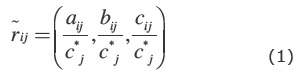
The Fuzzy Technique for Order Preference by Similarity to Ideal Solution (FTOPSIS) (Triantaphyllou and Lin, 1996) is a fuzzy multi-objective decision technique based on simple geometric concepts: the best alternative exhibits the shortest distance from the Best Ideal Solution (BIS) and the farthest distance from the Worst Ideal Solution (WIS) in a Euclidean sense. Just as the LW method, this approach requires as input data the mxn decision matrix DM and the weights wjr with j = 1,..,n measuring the criteria importance. Moreover, a fuzzification process associates to each value dmij of DM a fuzzy value d'ij, with 0 < d'ij < 1, defining the mxn fuzzified decision matrix D', depending on the user satisfaction degree with respect to the criteria.
There are seven called alternative hydrostratigraphic units to select the best aquiferous layer,where the hydrostratigraphic units are conglomerate and sandstone (Kcs); dolomite and limey dolomite (Kd); shale and calcareous marl (KML); lower massive limestone (KL1); lower marl and marly limestone (KM1); upper massive limestone (KL2); upper marl and marly limestone (KM1) from lower to upper respectively.
We want to select one of these seven units based on seven criteria (thickness, surface RQD, opening joints, joints distance, porosity, permeability, and bedding). The thickness, porosity, permeability, and bedding criteria have positive aspects and the surface RQD, opening joints and joints distance criteria have negative aspects, where the hierarchical structure for the decision is shown in Figure 4.
Step 1: Decision matrix and weights vector of criteria
The alternatives have been evaluated by different criteria and the results as decision matrix is presented as Table 2.
The weight vector of criteria is shown in Table 3.
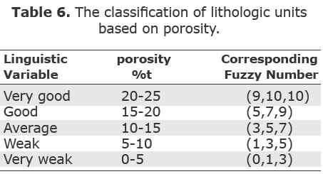
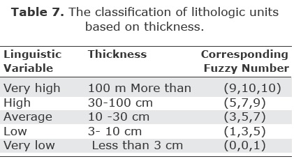
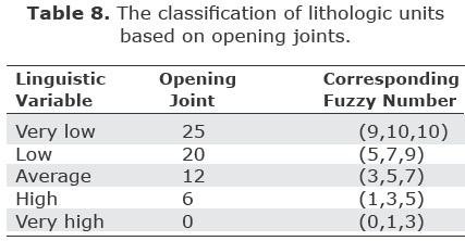
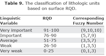
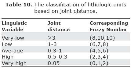
Tables 4 to 10 (5-6-7-8-9) are used to form the fuzzy decision matrix and weight vector.
Using the above tables, the fuzzy weight vector is obtained as Table 11.
Using the above tables, the fuzzy decision matrix is obtained (table 12).
Step 2: Unscaling the decision matrix
The first, Second, Third, fifth, sixth and seventh criteria have a positive aspect, and the following equation is used to unscaling the decision matrix.
Where
ai,j stands for the first component of vector in position column i, and row j, bi,j for the second component of the triade,and so forth.
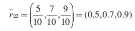
For example, in the first row and column of the decision matrix, we have:
The second, third and fourth criteria have a negative aspect, and following equation is used to unscaling the decision matrix.
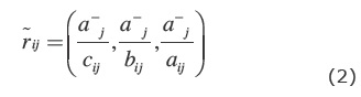
Where

For example, in the array for second row and fourth column of the decision matrix, we have:
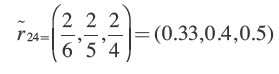
Other arrays for the unscaled decision matrix are calculated by the same calculations that the results would be as table 13.
Step 3: Obtain the weighted unscaled decision matrix
The method of calculating a few arrays of the matrix is as follows:
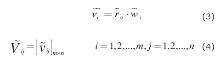
Where wj, j=1,2,..,n is the importance degree of each criterion and vij is Weighted normalized matrix element.
For example for v17 (Kcs Thckiness) and v23(KML Permeability):
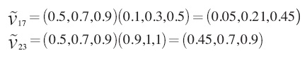
Other arrays for the unscaied decision matrix are calculated by the same calculations that the results would be as Table 14.
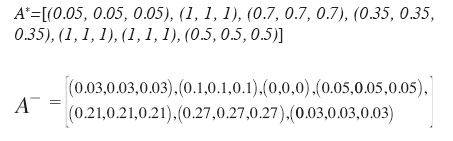
Step 4: Calculate the ideal (A*) and antiideal ( ) alternatives
The method of calculating a few arrays for the matrix is as follows:
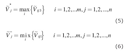
For example for v*7 (The maximum amount of Thickness) and  7 (The minimum amount of Thickness):
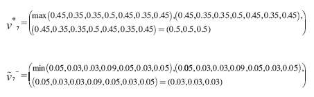
Similar calculations have been done for other alternatives with results as follows:
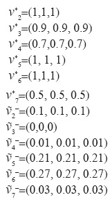
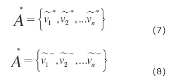
The fuzzy ideal (A*) and anti-ideal (A-) alternatives are defined as follows:
For example for A* and  :
:
Step 5: Determine the distance of any alternative from the ideal and anti-ideal (S* and  ) alternative and similarity attribute.
The distance of first alternative from the fuzzy ideal alternative of each of the criteria is calculated as follows:
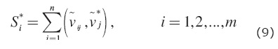
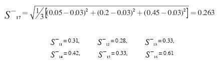
Where d, represents the distance measurement between two fuzzy numbers. For example for S*11 - S*17:
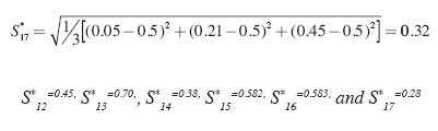
As a result, the distance of first alternative from the fuzzy ideal alternative is equal to:
The distance of first alternative from the fuzzy anti-ideal alternative of each of the criteria is calculated as follows:
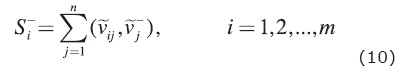
For example for  11–17:
Consequently, the distance of first alternative from the fuzzy ideal alternative or the closeness coefficients (similarity index) of each supplier according to distance from the fuzzy positiveideal solution (FPIS), S* and the fuzzy negativeideal solution (FNIS), , can be calculated as fallows:
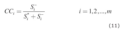
For example 1 and CC1 (For Conglomrate and Sandstone Unit or Kcs) is calculated as follows:
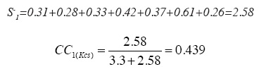
Thus, the similarity attribute for the alternative is equal to:
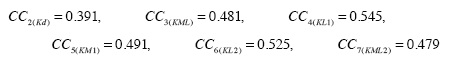
Similar calculation have been done for the other alternatives, and the calculation results for the distance of any alternative from the ideal and anti-ideal alternative has been inserted in the Tables 15-17 (16).
Each of the lithologic units whose its similarity attribute is better than the other units, has more potential unit to become the karstic aquifer. Thus, according to the results obtained from Table 17, the unit KL1 and KL2 are the best units to form the karstic aquifer, and the other units in the area have moderate and weak karstic aquifer conditions.
Conclusions
The objective of present research is to identify the most developed karstic lithologic unit of Haftad Gholleh area in South-eastern Arak in Iran, and the study has been done using the Similarity to Ideal Solution method.
This research indicates that the karst of Haftad Gholleh area can be classified into seven separate lithologic units which they are different by structural and hydraulic properties.
According to the research, the lower massive limestone or KL1 unit is the most important lithologic unit to form the karst of the area and after that, KL2 unit has been effective in forming the karst. Also, Base Lithologic unit of Cretaceous, include conglomerate and sandstone, the least karstic water reservoirs, does not play a important role to form the karst of Haftad Gholleh.
Bibliography
Abo-Sinna M.A., Amer A.H., 2005, Extensions of TOPSIS for multiobjective large-scale nonlinear programming problems. Applied Mathematics and Computation, 162, 243–256. [ Links ]
Agassi A.W., Afrasiabi A., 2004, Karst Hydrology", translation, publication The Design of Providing the Water Engineering Standards in the Country, 207. p. [ Links ]
Agrawal V. P., Kohli V., Gupta S., 1991, Computer aided robot selection: The multiple attribute decision making approach. International Journal of Production Research, 29, 1629–1644. [ Links ]
Cheng S., Chan C.W., Huang G.H., 2003, An integrated multi-criteria decision analysis and inexact mixed integer linear programming approach for solid waste management. Engineering Applications of Artificial Intelligence, 16,.543-554. [ Links ]
Deng H., Yeh C.H., Willis R.J., 2000, Intercompany comparison using modified TOPSIS with objective weights. Computers and Operations Research, 27, 963-973. [ Links ]
Emami H., 1992, Exploration of Qom Quadrangle, scale 1/250000, Geology survey of Iran , 4. p. [ Links ]
Feng C. M. & Wang R. T., 2001, Considering the financial ratios on the performance evaluation of highway bus industry. Transport Reviews, 21,449-467. [ Links ]
Hwang C.L., Yoon K., 1981, Multiple attribute decision making: Methods and applications. Springer. Berlin. [ Links ]
Jee D.H., Kang K.J., 2000, A method for optimal material selection aided with decision making theory. Materials and Design, 21, 199-206. [ Links ]
Kim G., Park C.S., Yoon K.P., 1997, Identifying investment opportunities for advanced manufacturing systems with comparative integrated performance measurement. International Journal of Production Economics, 50, 23-33. [ Links ]
Lai Y.J., Liu T.Y., Hwang C.L., 1994, TOPSIS for MODM. European Journal of Operational Research, 76, 486-500. [ Links ]
Liao H.C., 2003, Using PCR-TOPSIS to optimize Taguchi's multi-response problem. The International Journal of Advanced Manufacturing Technology, 22, 649-655. [ Links ]
Maxey G.B., 1964, Hydrostratigraphic units, Journal of Hydrology, 2, 124-129. [ Links ]
Olson D.L., 2004, Comparison of weights in TOPSIS models. Mathematical and Computer Modelling, 40, 721-727. [ Links ]
Opricovic S., Tzeng G.H., 2004, Compromise alternative by MCDM methods: A comparative analysis of VIKOR and TOPSIS. European Journal of Operational Research, 156, 445-455. [ Links ]
Parkan C., Wu M.L., 1997, On the equivalence of operational performance measurement and multiple attribute decision making. International Journal of Production Research,35, 2,963-2,988. [ Links ]
Seaber P.R., 1988, Hydrostratigraphic units, The Geology of North America, Geological Society of America, 2, 9-14. [ Links ]
Tong L.I., Su C.T., 1997, Optimizing multi-response problems in the Taguchi method by fuzzy multiple attribute decision making. Quality and Reliability Engineering International, 13, 25-34. [ Links ]
Triantaphyllou E., Lin C., 1996, Development and evaluation of five fuzzy multiattribute decision-making methods, International Journal of Approximate Reasoning, 14, 281–310. [ Links ]
Van Wagoner R.M., Mitchum R.M., Campion K.M., Rahmanian V.D., 1990, Siliclastic sequence stratigraphy in well logs, cores, and outcrops: Concepts for high-resolution correlation of time and facies, American Association of Petroleum Geologists Methods in Exploration Series, 7, 55-59. [ Links ]
Zanakis S.H., Solomon A., Wishart N., Dublish S., 1998,Multi-attribute decision making:A simulation comparison of select methods. European Journal of Operational Research, 107, 507-529. [ Links ]

