


Servicios Personalizados
Revista
Articulo
 Inglés (pdf)
 Artículo en XML
 Referencias del artículo
 Enviar artículo por email
Indicadores
-
 Citado por SciELO
 -
 Accesos
Links relacionados
-
 Similares en
SciELO
Similares en
SciELO
Compartir

 Permalink
Geofísica internacional
versión On-line ISSN 2954-436Xversión impresa ISSN 0016-7169
Geofís. Intl vol.50 no.3 Ciudad de México jul./sep. 2011
Artículo original
Subsidence in Celaya, Guanajuato, Central Mexico: implications for groundwater extraction and the neotectonic regime
Rafael Huizar-Álvarez*1, Luis Miguel Mitre-Salazar2, Salvador Marín-Córdova3, José Trujillo-Candelaria4 and Juventino Martínez-Reyes5
1 Instituto de Geología, Universidad Nacional Autónoma de México, Ciudad Universitaria, Delegación Coyoacán, 04510 México, D.F. México Fax: + 52 55 5622-4289, + 52 55 5550 8432 *Corresponding author: huizar@servidor.unam.mx
2 Centro de Geociencias, Campus Juriquilla, Universidad Nacional Autónoma de México Querétaro, Qro. México
3 Instituto Mexicano del Petróleo México D.F.
4 Consultor público Celaya Guanajuato, México
5 Centro de Geociencias Campus Juriquilla Universidad Nacional Autónoma de México Querétaro, Qro., México
Received: December 11, 2009
accepted: November 23, 2010
published on line: June 30, 2011
Resumen
El problema de la subsidencia y agrietamientos del terreno reportado en diferentes partes del mundo y en México, ha sido interpretado en la mayoría de los casos, como resultado de la extracción excesiva de agua subterránea. En la región de Celaya, Guanajuato, la información geológica e hidrológica analizada indica que el proceso que origina los hundimientos y agrietamientos es complejo, y que las condiciones de un área tectónicamente activa, ubicada en la zona de alta sismicidad del país y con manifestaciones de agua termal con temperaturas mayores a los 40°C, deben tener gran influencia en el proceso. Las evidencias geológicas indican que la formación de nuevas fisuras está asociada con el marco geológico-estructural en el subsuelo. La extracción no controlada de agua subterránea es un factor muy importante en el proceso, ya que ésta constituye el agente que modifica las características de saturación inicial de los materiales de relleno del valle, que constituye el acuífero, haciendo que resalten los rasgos estructurales pre existentes, por efecto del movimiento descendente, causado por la disminución de la presión del agua de poro, formando agrietamientos en las zonas de debilidad. Entonces las grietas se originarán preferencialmente en donde están las discontinuidades geológicas.
Palabras clave: subsidencia, grietas, fallas, Celaya-México, vulnerabilidad, extracción de agua subterránea.
Abstract
The problem of land subsidence and formation of earth fissures, in most cases reported in different parts of the world, has been exclusively interpreted as a result of excessive groundwater extraction. In the Celaya, Guanajuato region, geologic and hydrologic information indicates that the process causing this subsidence and earth fissuring is complex. The dynamic tectonics of the area located in an active seismic zone where thermal springs with temperatures above 40 °C are present, should influence the process. The geologic evidence indicates that the formation of new earth fissures is controlled by the geologic-structural framework that existed previous to the deposition of the alluvial valley infill. Uncontrolled groundwater extraction constitutes an important factor because it modifies the initial saturation of the valley infill material and enhances (reactivates) pre-existing structural features, producing a loss of pore water pressure. Most earth fissures in the Celaya area are related to pre-existing structural features.
Key words: land subsidence, earth fissure, faults, Celaya-Mexico, vulnerability, groundwater extraction.
Introduction
The city of Celaya is experiencing a problem similar to different cities of Mexico such as Aguascalientes, Querétaro, Mexico, Morelia, Salamanca, Irapuato, and around the world (i.e., Venice, Shanghai, Houston); namely, subsidence due to excessive groundwater extraction (Murck et al., 1997).
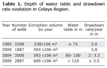
Groundwater extraction in Celaya began in 1910 and the number of wells has increased with the population. The impulse that was given to agricultural activity greatly propitiated withdrawal which has increased since the 1970's. In 1985, for example, 2,200 boreholes provided water for agricultural activity and for the urban population demand; in 1999, two thousand boreholes were censed by the Comision Nacional del Agua (CNA; National Water Commission, 1999). From the total wells available in 1999, 105 boreholes supplied the current urban demand, another 100 were dedicated to industrial activity, and the rest was oriented towards agricultural activities. The volume of total groundwater extraction in 1985 was 538 x 106 m3 / year, whereas in 2004 it reached 593 x 106 m3/ year and 600x106 in 2008 (CNA, 1981; 1999; 2004; 2008). The drawdown of the static water level increased from 10 meters in 1956 to more than 100 meters in 2008.
Meanwhile the Celaya urban center grew and also began to experience problems related to land subsidence. It is possible to assume that this was not just because the city of Celaya was pumping large quantities of groundwater. It is obvious that as urban areas expand, they often extend into former agricultural zones possibly already prone to subsidence and fissuring.
In Celaya the land subsidence phenomenon is characterized by a vertical differential consolidation of sediments along linear elements in the alluvial plain that border rectangular polygons. This differential consolidation giving rise to faults, is potentially more destructive when an entire area collapses in a homogeneous way. It is important to mention that as early as the 1950's, in some sectors of Celaya, earth fissures and settling have been produced by the processes of consolidation.
In Celaya, Trujillo-Candelaria (1985) documented for the first time the existence of two normal faults trending NW 30° SE, with lengths of 2 and 4 km and a vertical displacement of 0.80 m, and related them to long-lasting subsidence processes. Similar interpretations for the origin of earth fissures in the cities of Morelia, Aguascalientes and Ciudad Hidalgo have been formulated by Marín-Córdova et al., (1983), Lermo et al., (1996), and Garduño et al., (2001), respectively.
In the city of Celaya the soil shows an evident differential consolidation, their magnitude has increased and new earth fissures are appearing; contrastingly in the rural areas, subsidence processes are not easily detected. Where detected, earth fissures and gutters are more than 1 m in width and several dozen to hundreds of meters in length and display very little vertical movement. The visible depth of this crack type varies between 1 and 3 m.
The generation of faults and earth fissures that has been associated with subsidence present in the zone of Celaya, has been attributed in some cases to the existence of compressible deposits of variable thickness and to the presence of a vertical fault. In others cases it has been attributed to the possible existence of underground structures that could abruptly modify the potential area of compaction with respect to an adjacent area (Bell, 1981, 1988; Holzer and Pompeyan, 1981).
In spite of the potential danger, the formation and evolution of these earth fissures have not yet been completely understood and continue to be of great interest to many investigations in the field of subsidence (Hem, 1994; Burbey, 1996). Among the several theories that have sought to explain the origin and development of new fissures, some hydrologists postulate that the forces of horizontal groundwater flow, undermine and the evaporation process and can contribute in an important way (Lofgren, 1968; Narasimhan and Holzer, 1978; Alberro and Hernández, 1990; 1990a).
The following considerations are recognized as factors associated with subsidence and fissures origin during the processes of groundwater extraction.
When the groundwater is extracted for long periods and discharge greatly exceeds recharge, the aquifer experiences considerable loss of artesian pressure and experiences increases in effective stress, and subsequent strain and deformations.
The differential subsidence effects are often due to the presence of compressible sediments of variable thickness in the subsurface (Bouwer, 1977; Jachen and Holzer, 1979; Holzer and Pompeyan, 1981). These differential movements can cause extension in the surficial sediments.
In agreement with Burbey (2002); Ortiz-Zamora and Ortega-Guerrero (2007), we think, that when an abrupt lithology-related discontinuity exists in the hydraulic conductivity or transmissivity, or related to a given weakness zone, such as faults or heterogeneities, either in the aquifer or in the overlying unsaturated zone, the generation of new fissures in the unsaturated zone is possible if the tensional stresses in the neighborhood of the weakness zone is significant. Such faults may result in deformation of the land surface.
Taking into account the previous considerations, as well as our field observations, this study was focused to explain in which degree subsidence, fissures and normal faults in the Celaya area are related to natural processes, i.e., to the geologic characteristics of the area, or to groundwater extraction.
Methodology
Throughout the study all the available information, including documents as well as maps of the area, was analyzed later verified in the field. This initial analysis enabled us to establish a regional framework and conceive globally the problem.
The analysis and interpretation of lineaments on satellite images, as well as detailed analysis of diverse geologic maps, provided an integral vision of the geologic and structural context of this region. In a subsequent step, aerial photographs dating from 1973 were used to detect possible features related to subsidence in areas that at the time were not urbanized. In this way it was possible to recognize three main groups of lineaments with a very similar orientation and whose regional extension could be corroborated on satellite images. Some of the lineaments recognized in the aerial photographs were also verified in the field and in some cases it was possible to find evidence of subsidence effects, i.e., presence of settlements of the ground surface, and normal faults in the Celaya City.
On the other hand, differences, on the ground surface level, of the existing lineaments were measured in the city and in the adjacent rural areas where earth fissures also exist, and compared to those reported previously by Trujillo-Candelaria (1985); Vargas (1999).
The stratigraphy and the geologics structures of the study area were obtained from Suter et al. (1992), Aguayo and Marín (1987), Alaniz-Álvarez et al., (2001), and from the geologic cartography of the Instituto de Geología, UNAM. The infill of the alluvial plain to a depth of 300 meters was established from borehole logs provided by the CNA (1999). Finally, the evolution of the potentiometric surface, as well as the hydraulic properties of the materials of the area, was adopted from CNA (1999, 2004) data. This information, was used to elaborate the geologic and hydrogeological conceptual models, and to reach a preliminary model of the mechanics of the subsidence phenomenon in Celaya city area.
The physical context of the Celaya region
The study area is located in the eastern portion of an extensive plain named the Bajío Guanajuatense (Fig. 1) with an approximate surface of 1,170 km2 of which 500 km2 comprise an alluvial plain with an average elevation of 1,750 m, limited to the south and north by volcanic relief. The principals volcanoes are Cerro Grande, to the south, and San Pedro, and Palo Huerfano volcanoes to the north.
Hydrologically, the study area is located in La Laja River basin, that only has runoff in rainy season, but is continuously receiving the waste water of Celaya city. The river flows in a general north-south direction; but four lineament systems with respective orientation N-S; NE-SW; NW-SE: and E-W, control orientation changes of the river channel. For example three kilometers to the southeast of the city of Celaya, changes its course to an abrupt east-west trend.
Geology
Figure 2 shows the compiled regional geology modified after Consejo de Recursos Minerales (1999), Ortega-Gutiérrez et al., (1992), and supplemented by direct field observations. The mountainous terrain of volcanic origin bordering the Celaya City broad alluvial valley pertains to the Transmexican Volcanic Belt. From a regional point of view, the area forms part of the geologic provinces of the Transmexican Volcanic Belt and of the Central Highlands (Ortega-Gutiérrez et al., 1992). The limit between these provinces, in some cases can, easily be recognized by the presence of Plio-Quaternary volcanic rocks. The first province has a younger morphological expression that contrasts notably with that of the volcanic rocks in the second one, which are characterized by a more highly dissected relief. In other cases, the limit corresponds to faults.

Following we describe summarily, from the base to the top, the stratigraphic column:
The oldest rocks reported in the region are located in the northern part of Celaya, in the Rancho Rincón de Centeno and correspond to a volcano-sedimentary sequence with regional low grade metamorphism assigned to the Mesozoic (Mvs). The area where these rocks are exposed is small and the stratigraphic relationships with the overlapping units are discordant, occasionally by the presence of faults.
The rest of the stratigraphic column corresponds to a package of rhyolites from the Oligocene (Tv, Tof), and Neogene (Nb), and a sequence of rhyolitic tuffis dated as Miocene-Pliocene, that crop out mainly in the southeastern and nothwestern part of the study area. At some places these tuffis are very altered and are intercalated with a Tertiary conglomerate composed mostly of volcanic rocks.
The Oligocene-Pliocene volcanic rocks distributed in the northern part of the area are in some cases covered unconformably either by volcanic rocks of basic to intermediate composition of Plio-Quaternary age from the Transmexican Volcanic Belt (QTpv) or by alluvial or occasionally fuvial deposits that make up the valley floor.
Cenozoic alluvial and lacustrine deposits (Plio-Quaternary) constituted by gravel, sand, silt, and clay constitutes the infill of the Celaya plain. At the center of the plain these deposits reach thicknesses up to 200 m or more (Figures 3a and 3b). Considering that these alluvial deposits buried a paleorelief formed during the evolution of the Transmexican Volcanic Belt, it is interpreted that the facies and depositional conditions were very diverse volcanic lacustrine and alluvial sediments with variable thicknesses.

Structural Analysis
The predominant structures in the study area are normal faults and fractures observed in satellite images and aerial photographs that were previously reported on geologic maps. The 568 lineaments recognized (Figure 4a and b) on the satellite images were grouped in two main families: (a) the first one that contains lineaments oriented N 20°-70° E and (b) the second one shows a preferential trend of N 20°-60° W, both directions being almost orthogonal,. A third group contains lineaments with E - W and N - S orientation.
According to their age, these structures also constitute two main groups. The first one corresponds to Mesozoic faults and fractures, which only affected the Mesozoic fold rocks. The second one of Cenozoic age, affected both the Mesozoic rocks folds as well as the volcanic and volcano-sedimentary units in the upper part of the stratigraphic column.
It is important to note that the main trend of both structures sets is similar to that of the fault systems and mapped fractures previously recognized in the region, as well as in areas adjacent to the study region, where it has been confirmed that these lineaments systems are tectonically active (Suter et al., 1992; 1995; 1996; Garduño-Monroy et al., 2001; Alaniz-Álvarez et al., 2001). A minor number of lineaments is with E –W, N-S, respective orientation are associated to important grabens as that of the Chapala, Queretaro, Acambay, Cuitzeo and Bajío. The study area being located in the last one.
Alaniz-Álvarez et al., (2001), have described three regional faults systems, which were activated during the Oligocene-Miocene, affecting Mesozoic and Tertiary rocks of the study area. Toward the east of Celaya city they infer a fourth fault system (Figure 2).
These faults are: i) Bajio Fault, oriented N45°W and dipping towards the SW, verticals displacement greater than 500 m affect the Cretaceous rocks and Oligocene relief of northwest sector; ii) Joya-Ixtapa Fault; affecting La Joya, San Pedro volcanoes and Mesa los Palacios rocks, with a vertical displacement, estimated in 50m by Alaniz-Álvarez et al., (2001). This fault has a N48°E, direction and is dipping towards the SE; iii) Palo Huérfano Fault; cutting vertically the lava flow of the Palo Huérfano volcano; this fault has a NE68°NW direction and is dipping to the NW.
iv) San Miguel Allende Fault; at the northern portion of the study area has a N-S direction; according to Alaniz-Álvarez et al. (2001) this fault stops at the Palo Huérfano volcano, where it presents a vertical displacement of 200 m, and infer that this fault continues south on the plains of Celaya and suppose that it represents an extension of the Taxco Fault system.
The second and third faults systems were previously reported by Aguayo Camargo and Marín-Córdova (1987), and Marin-Cordova et al., (1983), who named them as the sixth regional system fault, that crosses the Transmexican Volcanic Belt from the Pacific coast, between the Balsas and Carrizal rivers, through in Morelia, Queretaro, and Ciudad Valle cities, up to Punta Juarez, Tamaulipas, at the Gulf of Mexico.
These faults were reactivated in the Miocene, and at present are seismically active and, corresponds to the active fault system of the Transmexican Volcanic (Delgado et al., 1993; Suter et al., 1992; 1995; Luhr, 1997; Aguayo and Marín, 1987).), and accordingly should present possible minimum displacements; the fractures occurring in the plain might be the answer to this activity.
In the urban area, faults associated with subsidence show a systematic orientation that varies between N30°W and N20°W (Figures 4a and 4b), being parallel to the second family of lineaments described previously. According to field mapping, subsidence is associated with a light ground deformation displayed by sinking areas, graben-forming faults as shown in Figure 5. Which coincide with the feature of recent and active faults that affect the urban area of Celaya; some of these lineaments, show small vertical movement.
From a structural point of view, the course of La Laja River is controlled by the fracture system N 20°-70° E; N 20°-60° W. The La Laja River, as mentioned above, originates north of study area and has practically a north-south trend in the city of Celaya, where it turns abruptly to the west. The course of the river between Comonfort and Celaya city shows systematic changes in its trajectory, following a regular pattern that could be associated with the existence of underground fractures. The north-south trend could be associated to the San Miguel Allende Fault System.
The fracture that appears to the west of San Miguel Octopan and crosses the La Laja River with an 80 cm opening, apparently has a recent origin and could be explained as a tectonic reactivation of the N65°-70°E fracture system (Figure 4b).
Hydrogeology
From a hydrogeologic point of view in the study area it is possible to identity:
i) an aquitard
ii) a mixed aquifer (intergranular- fissured)
i) The aquitard
The aquitard is composed of a heterogeneous sequence of interstratifed layers of sand, fine-grained tuffis and clays, occupying the central portion of the plain. The intergranular sediment comprises between 30-130 m of clays, 20-100 m of tuffis and 30 m of sand, with lavas in some areas. The maximum aquitard thickness is 90 m in the central zone of the plain, whereas at the periphery it is less than 20 m (Figures 3a and 3b), the hydraulic conductivity in the aquitard is 1 x 10⁻⁶ m2/s; the storage coefficient is 0. 003.
ii) The mixed aquifer
This unit consists mainly of layers of clays, sands, conglomerates and lava flows of variable thicknesses. In the northern part of the study area and at the bottom it is constituted of volcanic rocks of acid composition. Toward the south it is composed of basic and intermediate composition rocks (Consejo de Recursos Minerales, 1999). In the center of the plain, lava flows alternate at different depths with sands and conglomerates (Figures 3a and 3b).
The transmissivity values reported by CNA (1999) for this group of materials are 2.07 * 10-4 m2/s for the intergranular, and 1.65 * 10-3 m2/s for the fissured aquifer while the storage coefficient average 0.05.
In Celaya city, groundwater extraction has caused an important drawdown of the potentiometric surface from 12 to 25 m depth in 1956 to more than 90 m in 2004, towards the north, west and east of this city, the drowdown is more than 100 m (CNA, 2004). In Celaya and Villagran, this has been translated into an average drawdown of 2.8 m/year (Table 1).
Figures 6 a, b, c and d, show the time evolution and spatial distribution of the static water level from 1956 to 2004, it is possible to appreciate that the greatest depths correspond to the farming areas, with focuses at Villagran, Cortazar, Juventino Rosas toward the north and south of Celaya, with a drawdown of 112 m. This drawdown has started to be noted in 1985. From 1980 to 2004, the urban areas of Celaya, Villagran and Cortazar register drawdowns of 170 m and 190 m respectively, originating a hydraulic gradient of 0.002 % with an ENE to WSW trend. The water level has descended at a rate of 35 m in 20 year (1.75 m/y).
The direct consequences of this uncontrolled groundwater extraction are observed in the drying up of dug wells and shallow boreholes, the decrease of the extracted flow system, and the decline in the pore pressure which result in the consolidation and formation of earth fissures in the urban area and in some rural areas. Another important fact is that the number of boreholes increased directly with the demand of water. In 1985, 2,200 existing boreholes had depths ranging between 100 and 250 m (Trujillo-Candelaria 1985), and from 1991, new perforations reached more than 300 m.
Subsidence
Subsidence must be considered as a continuous and long-lived process where different factors determining its occurrence. In particular subsidence and fissures are geological features that are accelerated by man through long-term groundwater extraction, and they represent a disruption of the natural equilibrium. Subsidence process seems to be controlled by the existence of compressible sediments with particular mechanical properties.
Under natural conditions the discharge of a hydrogeologic system produces minimum decreases in the thickness of materials of the saturated area, which can recover later when the recharge takes place. This has been defined as the reversible elastic consolidation (Bell, 1981; Bell, 1988).
Continuous groundwater extraction during a long period of time causes the thickness of the saturated area to diminish constantly, and the effect of non-reversible consolidation can take place. This can be explained by taking into account that when extraction of the interstitial water (pore water) and the hydrogeologic conditions do not allow its recovery, the pressure of the fluid (hydraulic head) diminishes and produces compaction of the land. In addition, these effects can be increased by the load of the urban construction, as in the city of Celaya where there is considerable sinking, while in the irrigated areas that surround the city, the groundwater extraction effect, when present, is evident mainly by earth fissures.
In the Celaya region consolidation and sinking effects of the land surface have been known since the decade of the 1950's (Oropeza-Orozco, personal communication), but it was not until the decade of the 1980's that, due to problems that it caused, the first studies were made. Trujillo-Candelaria (1985) reported that the area affected by the subsidence is limited by two faults that he called, the I) Oriente Fault and II) Poniente Fault. The same author in 1991 described the presence of three additional faults: III) Universidad Pedagogica, IV) Insurgentes, V) Praderas de la Hacienda, and VI) recently this author 2008 described another new fault that named Gobernadores (Trujillo-Candelaria, personal communication) (Figure 7). The decade of the 1990's was a period when sinking was more conspicuous (Vargas, 1999) and at present the affected area continues growing.
The mentioned faults have variable lengths and show different vertical displacements. All of them are systematically oriented NW 30º SE, and show a slight inclination toward the northeast and toward the southwest. In spite of not having a continuous register of the movement along these lineaments, the available measurements of the effects that they caused in the urban area allows to us give an explanation of the extention of the compaction and its possible future effect (Table 2, the main characteristic and subsidence effects of these faults are reviewed here.
I) The Oriente fault
This fault crosses the city with a NW 30° SE orientation and dips to the NE. Consists of an aligned sinking, with a maximal depths of 2 meters, and affecting many urban and industrial facilities located in what at that time were agriculture zones, such as those buildings pertaining to Comisión Federal de Eléctricidad and to FOVISSSTE (Trujillo-Candelaria 1985).
II) Poniente fault
This Fault has practically the same orientation and depth as the previous one. Several constructions have been affected by this fault i.e., building of Comercial Mexicana, which must be demolished before an imminent collapse, and many homes located in the Alameda district. Along its traces, this feature affects petroleum pipelines, waste water conduits, and highways and it disappears at both extremes in agriculture zones.
III) The Universidad Pedagogica fault
Between the Oriente and Universidad Pedago gica faults, a small NW-SE oriented graben and horst has formed (Figures 4a and b, and 5). The associated faults affect the constructions in general with vertical landslides producing steps that vary from a few centimeters to up to 3.20 m of maximum displacement.
IV) Insurgentes fault
Is located approximately 1,500 m, east of the previous structures and it also has a similar trend of NW 30º SE. This fault was first identified at the end of the rainy season in 1984 (Trujillo-Candelaria, 1985), with the presence of small aligned gulliers that formed a creek. It has a length of only 1,200 m and its displacement is of several centimeters and dips toward the northeast.
V) The Praderas fault
Located in the northern part of Celaya city, it is oriented N 15º W and shows a drop about 80 cm, to northeast, and it affects some urban construction of Praderas de la Hacienda residential neighbouring. This fault can also be trace to neighbouring fields.
During the months of July 1996, June 1997 and September 1998, Vargas (1999) monitored the Oriente, Poniente and Universidad Pedagogica faults, and concluded that the Oriente Fault seems to be the most active and that the largest biggest descents correspond to the central and southern part of the city.
VI) Gobernadores fault
(Trujillo-Candelaria, personal communication 2008) describes this new fault, associated with the most recent earth fissures originates in Ceyala city. Trujillo named this fault Gobernadores. Is located approximately 2 km to northeast of Insurgentes fault, it shows a NW trend and a drop of 0.50 cm and dip to SW.
In the present investigation the relative sinking was measured in different places along each fault. In table 2, the maximum and minimum vertical displacements values obtained in this study are compared respectively with to those reported by Trujillo-Candelaria (1985; 1991) and Vargas (1999). For each epoch, the measurements were made taking in account the vertical topographic gradient (the sinking vertical difference) between the floors of the houses existents on both sides of the fault.
These data are of a relative nature because they are not referred to a topographical reference plane. Therefore the Table 2, contains relative values and they represent the places with smallest and largest sinking. It is necessary to mention that the topography of the study area presents slopes down from north to south. Although a systematic monitoring of the subsidence does not exist in Celaya, it is estimated about a mean of 15 cm/yr in this region. The effects of subsidence increased considerably from its first manifestations up to 1983, which led the inhabitants of the city of Celaya, to request governmental aid to repair the damages to their houses and buildings.
Discussion
As already mentioned several studies previously carried out with this purpose in Mexico and in some other countries have proposed that the phenomenon by which the fissures originate has a direct and exclusive association with the subsidence process as a result of the excessive extraction of groundwater, and the mechanical properties of material (Bergado et al., 1987; Ortega-Guerrero et al., 1999; Carbognin et al., 2000; Gabrych and Neighbors 2000; Burbey, T.J., 2002; Xiaoqing et al., 2008; Auvinet 2009 Carreon-Freyre et al., 2009; Phien–wej et al., 2009).
If one takes into account that a considerable number of boreholes exists in the study area and in the neighboring villages, and the withdrawal of water since 1950 has been excessive, it seems reasonable to expect that the previous assumption indeed could hold for the case of Celaya, This proposed mechanism is in part satisfactory, However these studies have avoided the geological influence on the distribution, and geometry of fissures, i.e, some fissures can have a distribution, orientation and irregular form but, many others have a regular form, and geometric distribution and are linear, this is an evidence of geological structure control in the origin, and growing of some fissures and subsidence. Therefore, consideration of some additional factors would help to refine or modify the previous proposed mechanism that could provide a more detailed understanding of land subsidence and cracking origin. Among the factor to take into accounts, one of the most important is the basic geologic context within which the fissures and faults are present and have been generated. Fissuring only occurs in areas with certain geological conditions such as those present in the Celaya alluvial plain, i.e., the presence of poorly consolidated and heterogeneous sequences of clastic sediments deposited mainly over an irregular topography due to tectonic movements. The lithology and thickness of the different units that constitute the alluvial sequence must be extremely variable, both in a vertical sense as well as in their horizontal distribution.
We can observe that distribution of earth fissures and fault systems in Celaya are remarkably orthogonal to each other. There are well-defined parallel linear recent faults, with a systematic vertical displacement to the east, with the exception of the most recent one that is toward the west. The orientation of this fault systems is consistent with one of the preferential trends of the regional faults formed before the alluvial plain formation.
This observation suggest a correlation between the recent crackings and the reactivation of the pre-existing faults that lie below the deposits of the alluvial valley and are not exposed at the surface. Thus, the fissuring processes, the sinking areas, and its geometrical distribution seem to show a close relationship with the structural pattern of the basement, reflecting in some way the arrangement and distribution of the pre-existing faults. Therefore this close correlation supports the interpretation that there is the geological control of the this morphological features.
Furthermore the trend north - south of the la Laja river could be possibly controlled by San Miguel Allende fault. The apparent control that the already mentioned structures have in the subsoil to make those areas susceptible to cracking, together with the differential compaction propitiated by excessive extraction of groundwater, could explain the origin of this phenomenon.
In essence, it is possible to assume that the earth fissures have two possible origins: one is of a tectonic-control component and another of the hydrodynamic type. That is, it is possible to postulate the hypothesis that the loss of pore pressure water due to the quick drawdown of the potentiometric level moves toward the zones corresponding to pre-existent areas of weakness. This gives rise to permeable zones (pseudo channels) where water and sediments (silt, clays) can descend. Where the area of pre-existent weakness corresponds to a fault zone, or earth fissure, the result will be an earth fissure.
Additionally, it should be kept in mind that the alluvial lacustrine sequence is lithologically heterogeneos with the corresponding mechanical properties and therefore the hydraulic conductivity variations having surely an important influence on the fissure formation processes; Principally in the areas where the materials are interdigitated (Ortiz-Zamora and Ortega-Guerrero, 2007).
An additional factor is the relationship to the tectonic regime of the area. As already mentioned, there is evidence of recent tectonic and volcanic activity in the study area and it would be natural and possible for some of the main effects of these geological processes to be present and continue acting in the processes of modeling natural landscape. Although in the study region, important seismicity associated with the generation of faults and fissures has not been reported, this activity exists. The effects of some earthquakes have been felt in the region, such is the case of the 21 January 2003 earthquake (inhabitants, oral communication). The magnitude has not been quantified due to the absence of an appropriate and systematic monitoring system in the study area.
Conclusions
Interpretation of the different subsidence processes that generate earth fissures by differential compaction in the great majority of the cases is not an easy, simple and evident.
In this study we have shown that there is close correlation between the geological context of the study (in particular the volcanic and tectonic regime) and the subsidence and fracture generation. The influence of these processes should be included as important factors in the models accounting for the generation of the earth fissures in close combination with the differential compaction produced by uncontrolled groundwater extraction, together with the differential mechanical properties of materials. Therefore the geological setting is a main factor controlling the emplacement of earth fissures and subsidence in this area.
Thus this study illustrates especially that just a single vector can not be considered responsible of subsidence and fracture generation processes. The subsidence phenomenon, in general, in the study area as well as in other parts of Mexico and the world has been mainly associated with excessive groundwater extraction and focused in general terms on aspects related to soil mechanics. Nevertheless in many cases the importance of the possibility that other geologic processes control the subsidence process should be considered, as pointed by this case study. In fact the six main faults affecting the urban constructions in Celaya City, correspond with the described NW-SE system of fractures (Figs. 4a, b); this supports the influence of geological structure in controlling the emplacement and orientation of the fissures and faults in a lacustrine fill (Fig. 5), subject to excessive groundwater extraction, where the groundwater flows through the identified lineaments and show the existence of these lineament by sub-surface erosion occurring within them.
Acknowledgements
This paper was made possible by the logistical support of the Instituto de Geología (UNAM). We grateful to Felix Malpica for collaboration with the field work, and Ma. Magdalena Espinoza-Jaramillo, her collaboration on cartographic desk drawing. We also very grateful to Dr. Oscar Campos Enriquez for his suggestions and the english corrections.
Bibliography
Aguayo-Camargo J.E., Marín-Córdoba S., 1987, Origen y evolución de los rasgos morfotectónicos postCretacicos de México. Bol. Soc. Geol. Mex T. XLVIII, (2), 15-39. [ Links ]
Alaniz-Álvarez S.A., Nieto-Samaniego A., Reyes-Zaragoza M.A., Orozco-Esquivel T., Ojeda García A., Vasallo L.F. 2001, Estratigrafía y deformación extensional en la región San Miguel Allende-Querétaro. México. Rev. Mexicana de Ciencias Geológicas, 18,(2),129-148. [ Links ]
Alberro J., Hernández R., 1990, Génesis de las grietas de tensión en el Valle de México, el subsuelo de la Cuenca del Valle de México y su relación con la ingeniería de cimentaciones a cinco años del sismo. Soc. Mex. Mech. Suelos, 95 p. [ Links ]
Alberro J., Hernández R., 1990a, Fuerzas de filtración y fracturamiento hidráulico. UNAM. Serie Azul Instituto de Ingeniería, 528, 109 p. [ Links ]
Auvinet G., 2009, Land subsidence in Mexico City, in: Proc. XVIIth IMSSGE. Conf. Geotechnical engineering in urban areas affected by land subsidence. Ed. Auvinet. G. and Juárez. M. vol. 36 Alejandria Egypt, pp. 3-13. [ Links ]
Bell J.W., 1981, Subsidence in Las Vegas Valley. Nevada Bureau of Mines and Geology, Bull, 95, 84 p. [ Links ]
Bell F.G., 1988, Subsidence associated with the extraction of fluids. Engineering Geology of Underground Movements. Geol. Soc. Engin. Geol, Sp. Pub, 5, 363-376. [ Links ]
Bergado D.T., Nutalaya P., Balasubramaniam A.S., Apaipong W., Chang C.C., Khaw L.G., 1987, Causes, effects and predictions of land subsidence in AITCampus, Chao Phraya plain, Bangkok Thailand. Bull. Assoc. Eng. Geol., 25, 1, 57-81. [ Links ]
Bouwer H., 1977, Land subsidence and cracking due to groundwater depletion. Groundwater, 15, 358-364. [ Links ]
Burbey T.J., 1996, Pumpage and water-level change in the principal aquifer of Las Vegas Valley, Nevada 1980-90. Nevada Div. Water Res. Information Report, 34, 224 p. [ Links ]
Burbey T.J., 2002, The influence of fault in basin-fill deposits on land subsidence, Las Vegas Valley, Nevada, USA. Hydrogeol. Journ., 10, 525-538. [ Links ]
Carbognin L., Cecconi G., Ardone A., 2000, Interventions to safeguard the environment of the Venice Lagoon, Italy against the effects of land elevation loss, in Proc,6th Int. symp. Land subsidence, vol 1, Ravena Italy, pp. 309-324. [ Links ]
Carreon-Freyre D.C., Cerca M.L., Ochoa G.H., 2009, Estudio de propagación del fracturamiento ocasionado por subsidencia en dos áreas urbanas geológicamente contrastantes de México: las ciudades de México D.F. y Querétaro. in Proc. XVIIth IMSSGE. Conf. Geotechnical engineering in urban areas affected by land subsidence. Ed. Auvinet. G. and Juárez. M. vol. 36, Alejandria Egypt, pp. 49-57. [ Links ]
Comisión Nacional del Agua CNA., 1981, Estudio geohidrologico de los valles de Silao–Pénjamo Estado de Guanajuato, contrato GAZ, 80-75, 90 p. [ Links ]
Comisión Nacional del Agua CNA., 1999, Estudio hidrogeológico y modelo matemático del acuífero del valle de Celaya, Guanajuato, (plan estatal hidráulico de Gto), contrato CEAS-APA-GTO-ESP-98-0099, 150 p. [ Links ]
Comisión Nacional del Agua CNA., 2004, Cuantificación de la extracción del Agua Subterránea en el Valle de Celaya, Gto., Aplicando Técnicas de Percepción Remota. Contrato 2458. Gonwana Exploraciones. S.A. C.V, 100 p. [ Links ]
Comisión Nacional del Agua., 2008, Actualización de la disponibilidad media anual de agua subterránea acuífero (1115) valle de Celaya, Estado de Guanajuato. Gerencia de evaluación y ordenamiento de acuíferos. Diario oficial de la Federación, Agosto. [ Links ]
Consejo de Recursos Minerales., 1999, Carta Geológico-Minera Celaya F14-C64, Guanajuato. Secretaría de Comercio y Fomento Industrial. Pachuca, México. [ Links ]
Delgado G.H., Martin del Pozo A.L., 1993, Pliocene to Holocene volcanic geology at the junction of Las Cruces Chichinautzin and Ajusco ranges, southwest of Mexico City. Geofísica International, 32, 511-522. [ Links ]
Gabrysch R.K., Neighbors R.J., 2000, Land-surface subsidence and its control in the Houston-Galveston region, Texas, 1906-1995, in Proc. 6th Int. Symp. Land subsidence, vol 2, Ravena, Italy, pp 81-92. [ Links ]
Garduño-Monroy V., Arreygue–Rocha E., Israde-Alcántará I., Rodríguez T., 2001, Efectos de las fallas asociadas a sobreexplotación de acuíferos y la presencia de fallas potencialmente sísmicas en Morelia, Mich. México. Rev. Mexicana de Ciencias Geológicas, 18, 1, 37-54. [ Links ]
Hem D.C., 1994, Hydraulic forces that play a role in generating fissures at depth. Bull. Assoc. Eng. Geol, 31, 293-302. [ Links ]
Holzer T.L., 1978, Documentation of potential for surface faulting related to groundwater development in Las Vegas Valley, Nevada. US. Geol. Surv. Open–File Rep, 79-79, 11 p. [ Links ]
Holzer T.L., Pompeyan E.H., 1981, Earth fissures and localized differential subsidence. Water Res. Ress, 17, 223-227. [ Links ]
Jachen R.C., Holzer T.L., 1979, Geophysical investigations of ground failure related to groundwater extraction in Picacho basin, Arizona. Groundwater, 17, 574-585. [ Links ]
Lermo-Samaniego J., Nieto-Obregón J., Zermeño M., 1996, Fault and fractures in the valley of Aguascalientes, preliminary microzonification, in World Conf. on Earthquake Engin. 11th Amsterdam, Elsevier Paper 1651. [ Links ]
Lofgren B.E., 1968, Analysis of stresses causing land subsidence. U.S. Geol. Surv. Prof. Paper 600-B, 219-225. [ Links ]
Luhr J,F., 1997, Extensional tectonics and diverse primitive volcanic rock in the western Mexican Volcanic Belt. Canadian Minera, 135, 473-500. [ Links ]
Marín-Córdova S., Aguayo C.J.E., Mandujano V.J., Gazcón VI., 1983, Geología con fines económicos en los Municipios de Jungapeo, Cd. Hidalgo, Zinapecuaro y Zitacuaro, Estado de Michoacan. UNAM. Instituto de Geología, para el Gobierno de Michoacan, 40 p. [ Links ]
Murck B., Skiner G., Porter S., 1997, Subsidence. in Dangerous Earth: An Introduction to Geologic hazards. Ed. John Wiley & Sons. Inc, pp. 173-189. [ Links ]
Narasimhan TN., Holzer TL., 1978, Possibility of soil deformation in the partially saturated zone due to pore pressure changes. Geol. Soc. Am. Abstr. Program, 10, 138 p. [ Links ]
Ortega-Guerrero A., Rudolph L.D., Chery A.J., 1999, Analysis of long-term land subsidence near Mexico City; field investigations and predictive modeling. Water Resour. Res., 35, 11, 3327-3341. [ Links ]
Ortega-Gutiérrez F., Mitre-Salazar L.M., Roldan Q.J., Aranda-Gómez J., Moran-Zenteno D., Alaniz-Álvarez S, Nieto-Samaniego A., 1992, Mapa Geológico de la República Mexicana y texto explicativo de la quinta edición de la Carta Geológica de la República Mexicana. Esc. 1:200 000 UNAM. México. [ Links ]
Ortiz Zamora D.C., Guerrero-Ortega M.A., 2007, Origen y evolución de un nuevo lago en la planicie de chalco; implicaciones de peligro por subsidencia e inundación de áreas urbanas en el valle de Chalco (Estado de México) y Tlahuac (Distrito Federal). Invest. Geográficas. Universidad Nacional Autónoma de México, 64, 26-42. ISSN 0188-4611. [ Links ]
Phien-Wej N., Giao P.H., Nutulaya P., 2009, Overview of land subsidence from deep well pumping in Bangkok. in Proc. XVIIth IMSSGE. Conf. Geotechnical engineering in urban areas affected by land subsidence. Ed. Auvinet. G. and Juárez. M. vol. 36 Alejandria Egypt, pp. 15-22. [ Links ]
Secretaria de Desarrollo Urbano y Ecología, SEDUE., 1988, Estudio de factibilidad técnico– financiero para sistema de agua potable y alcantarillado de ciudad de Celaya Gto. Dir. Gral. Infraestructura Urbana, 250 p. [ Links ]
Suter M., Carrillo-Martinez M., Quintero-Legorreta O., 1996, Macroseismic study of shallow earthquakes in the central and eastern parts of the Trans-Mexican Volcanic Belt, Mexico. Seismological Soc. Amer. Bull, 86, 6, 1952-1963. [ Links ]
Suter M., Quintero-Legorreta O., Jonhson C.A., 1992, Active faults and state of stress in the central part of the Transmexican Volcanic Belt, Mexico. Venta del Bravo fault. Jour. Geophy. Res, 97, 8b, 11983-11994. [ Links ]
Suter M, Quintero-Legorreta O., López-Martinez M., Aguirre-Díaz G., Farrar E., 1995, The Acambay graben; active intra arc extension in the Trans-Mexican Volcanic Belt, Mexico. Tectonics, 14, 1245-1262. [ Links ]
Trujillo Candelaria J.A., 1985, Subsidencia de terrenos en la ciudad de Celaya Gto. Soc. Mex. de Mec. de Suelos, 1, 35-42. [ Links ]
–––––––––– 1991, Fallamiento de terrenos por efecto de la sobreexplotación de acuíferos en Celaya Gto. XXIII AIH-Congr. Inter. Sobreexplotación de acuíferos. Canarias, España. T. I, p 175-178. [ Links ]
Vargas Venhumea, R.M., 1999, La subsidencia y su problemática en la ciudad de Celaya Gto. Undergraduate thesis Fac. Filosofía y Letras, UNAM. México. [ Links ]
Xiaoqing Shi, Yuqun Xue, Jichun Wu, Shujun Ye, Yun Zhang, Zixin Wei, Jun Yu, 2008, Characterization of regional lans subsidence in Yangtze Delta, China the example of Su-XiChang area and the city of Shanghai. Hydrogeol. Journ., 16 (3): 593-608. [ Links ]

