


Servicios Personalizados
Revista

Articulo
 Inglés (pdf)
 Artículo en XML
 Referencias del artículo
 Enviar artículo por email
Indicadores
 Citado por SciELO
 Links relacionados
-
 Similares en
SciELO
Similares en
SciELO
Compartir

 Permalink
Geofísica internacional
versión On-line ISSN 2954-436Xversión impresa ISSN 0016-7169
Geofís. Intl vol.48 no.2 Ciudad de México abr./jun. 2009
Article
Late Holocene tectonic land–level changes and tsunamis at Mitla lagoon, Guerrero, Mexico
M. T. Ramírez–Herrera1*, A. B. Cundy2, V. Kostoglodov3, and M. Ortiz4
1 Centro de Investigaciones en Geografía Ambiental, Universidad Nacional Autónoma de México, Campus Morelia, Michoacán, México. * Corresponding author: mtramirez@ciga.unam.mx
2 School of Environment and Technology, University of Brighton, Lewes Road, Brighton BN2 4GJ, UK. E–mail: A.Cundy@brighton.ac.uk
3 Instituto de Geofísica, Universidad Nacional Autónoma de México, Del. Coyoacán, 04510 Mexico City, México. E–mail: vladi@servidor.unam.mx
4 Departamento de Oceanografía Física, Centro de Investigación Científica y Educación Superior de Ensenada, Km. 107, Cta. Tijuana– Ensenada, 22860, Ensenada, BC, México. E–mail: ortizf@cicese.mx
Received: October 5, 2008
Accepted: November 21, 2008
Resumen
Información sedimentológica, estratigráficay geoquímica registra cambios abruptos de elevación, subsidencia de la costa y cambios en la salinidad de la laguna Mitla, que pueden estar asociados a un tsunami en 3400–3500 AP aproximadamente. Las observaciones son respaldadas por datos de microfósiles (polen, diatomeas y fitolitos) de otros estudios en la costa de Guerrero. Los datos de estratigrafía indican una tasa de sedimentación de aproximadamente 1mm/año. El registro del nivel del mar de corto plazo a partir de 1952 de datos de mareógrafos son comparados con el registro de largo plazo (del registro sedimentario, c. 3500 años AP) de la deformación cosísmica esperada en la costa. Los sismos grandes recientes ocurridos en la zona de subducción Mexicana central rompieron un área de ancho limitado, de aproximadamente ~60 km, pero algunos sismos prehistóricos pudieron romper la interfase de acoplamiento de placas completa hasta la trinchera, generando por tanto subsidencia costera significativa y probablemente un tsunami grande.
Palabras clave: Cambios de nivel del mar, holoceno, sismos, tsunami, lagunas costeras tropicales, paleoambientes.
Abstract
Sedimentological, stratigraphic and geochemical data record abrupt land elevation change, coastal subsidence, and changes in the salinity of Mitla lagoon that may be associated with a tsunami around 3400–3500 yr BP. The observations are supported by microfossil data (pollen, diatoms and phytolith) from other studies on the Guerrero coast. Stratigraphic data indicate an average Late Holocene sedimentation rate of about 1 mm/yr. Short–term sea–level records from 1952 of tide gauge data are compared with expected coseismic coastal deformation, and long–term records of coastal deformation from the sediment record c. 3500 yr BP. Recent large earthquakes in the Central Mexico subduction zone ruptured an area of limited width of about ~60 km, but some prehistoric earthquakes may have ruptured the entire coupled plate interface almost up to the trench, thus generating significant coastal subsidence and possibly a large tsunami.
Key words: Sea–level changes, holocene, earthquakes, tsunami, tropical coastal lagoons, paleoenvironments.
Introduction
Repeated tectonic land–elevation changes and tsunamis may leave a distinct sedimentary, micro–palaeontological and geochemical signature in the coastal stratigraphic record at plate margins. The coastal sedimentary record has been examined in various settings to assess the magnitude and return times of historical earthquakes and tsunamis (Atwater, 1987, Long and Shennan, 1994, Atwater et al., 1995, Minoura et al., 1996, Nelson et al., 1996, Nanayama et al., 2003, Cundy et al 2000, Chagué–Goff et al., 2002, Cisternas et al., 2005, Dominey–Howes et al., 2006, Kortekaas and Dawson, 2007; Sawai et al., 2008).
The 2004 Sumatra earthquake and tsunami has raised awareness on the need for paleoseismology studies to help assess earthquake and tsunami hazards at subduction zones. Searching for the traces of prehistoric giant earthquakes is critical for the evaluation of great earthquake potential (Satake and Atwater, 2007). Paleoseismological studies are particularly valuable in areas where there is a limited instrumental and documentary record of previous tectonic events. Relatively few paleoseismic data are available at complex plate boundaries (Natawidjaja et al., 2006, Nanayama et al., 2003; Cisternas et al., 2005, Atwater et al., 1995, 2004; Atwater and Moore, 1992; Sawai et al., 2004, 2008) such as the Mexican subduction zone, where changes in plate convergence rate and angle of subduction, or subduction of major fracture zones and ridges have been documented.
More than 50 documented tsunamis have been registered since 1732 along the Pacific coast of Mexico (Sanchez and Farreras, 1993; Farreras, 1997). Relative sea–level change observations are based mainly on about 50 years of geodetic measurements (Kostoglodov et al., 2001; Lowry et al., 2001; Larson et al., 2004). Studies of coastal sediments for Holocene sea–level change and active tectonic deformation are much less common (Curray, 1969; Gonzalez Quintero, 1980; Boding and Klinger, 1986; Ramirez–Herrera et al., 1998, 2004; Ramirez–Herrera and Urrutia–Fucugauchi, 1999a; Ramirez–Herrera and Zamorano Orozco, 2002). Recent geomorphic and stratigraphic studies on the Guerrero coast have shown the feasibility of using the stratigraphic record in lagoonal sediments to document past earthquake and tsunami events (Ramirez–Herrera et al., 2007). Here we present the results of a study of lagoonal marsh sediment stratigraphy and geochemical sediment composition in Laguna Mitla, Guerrero.
What is the signature of active tectonic deformation and relative sea–level changes on the Pacific coast of Mexico? We discuss the tectonic setting and earthquake and tsunami history of the Guerrero coast. Results of sediment and geochemical analyses are presented and interpreted to identify changes in paleosalinity and local paleoenvironment. The results and interpretations are used to reconstruct paleoenvironmental changes and trace the signature of past relative sea–level changes and possible ancient marine incursions in the lagoonal mashes of the Guerrero coast.
Tectonic Setting, Earthquakes and Tsunami History
The Pacific coast of southwest Mexico parallels the subduction zone of the Rivera–Cocos plate under the North American plate in the south of Mexico (Fig. 1). Subduction has produced several large earthquakes of Mw > 7 over the last century (Singh et al., 1981, 1986; Kostoglodov and Ponce, 1994). The possibility of larger magnitude events is confirmed by the Jalisco 1932 earthquake (Mw 8.2), the Colima 1995 earthquake (Mw 8.0), and the Michoacan earthquake of 1985 (Mw 8.1) that devastated part of Mexico City, causing great human losses and economic damage estimated in the range of billions of dollars (UNAM, Seismology Group, 1986).
Plate convergence rates vary from 5.3 cm/yr to 5.8 cm/yr (Fig. 1). The Northwest Guerrero seismic gap has experienced large historical earthquakes, notably in 1911 (Ms 7.8). However, no large magnitude events and only a few Ms  6 events have occurred since 1911 near the Guerrero gap edges (Lowry et al., 2001; Larson et al., 2004). A major interplate earthquake of estimated magnitude Mw 8.1 to 8.4 may have a high probability of occurrence along this coast (Suarez et al., 1990; Anderson and Menking, 1994; Valdes–Gonzalez and Novelo–Casanova, 1998). The probability of tsunami occurrence is also high. Historical records indicate that at least 10 tsunamis have impacted the Guerrero segment since 1732 AD (Sanchez and Farreras, 1993). Tsunami data analysis recorded by tide gauges during the earthquakes of 11 May 1962 (Mw7.1) and 19 May 1962 (Mw7.0) suggests a coseismic uplift of 15+/–3 cm and 7 +/– 3 cm in Acapulco (Ortiz et al., 2000). The surface projection of the estimated rupture areas of these two events mostly lies onshore, southeast of the study area. However, several moderate magnitude thrust earthquakes have ruptured the plate interface offshore suggesting that the width of the coupled seismogenic zone may extend almost to the trench. One recent near–trench tsunamigenic earthquake suggests that the coupled zone can extend up to the trench (Iglesias et al., 2003). If the entire width of the seismogenic zone ruptures in a large subduction thrust event a substantial coseismic subsidence could occur inland along the coastal area of Guerrero.
Tsunami records in Mexico are produced by tide–gauges and to a lesser degree by post–tsunami measurements or visual observations. Tide–gauge measurements in Mexico began in 1952. Post–tsunami field observation were carried after the October 9, 1995 Colima–Jalisco earthquake Mw 8 (Ortiz et al., 1998, 2000; Borrero et al., 1997). Thirty–four historical tsunamis originated from local sources and were produced by earthquakes (Sanchez and Farreras, 1993; Farreras, 1997). The maximum wave height recorded at tide–gauge stations is 3.0 m. However, historical data for the last three centuries, based on visual observations, suggest that the tsunami wave heights on the Mexican Pacific coast can be much larger. According to documentary records, the November 16, 1925 tsunami that hit the Zihuatanejo coast, Guerrero state, produced a wave 11 m high, and a 3–8 m high tsunami wave in 1782 in Acapulco, Guerrero (Sanchez and Farreras, 1993; Farreras, 1997). The tsunami of June 22, 1932 at Cuyutlan, Colima state, produced a wave 10 m high (Sanchez and Farreras, 1993; Farreras, 1997). Both tsunamis caused considerable damage and human loss.
Historical data suggest the occurrence of a large earthquake on March 28, 1787 rupturing approximately 450 km of the Mexican subduction zone with an equivalent magnitude of about 8.5. The tsunami reached 6.5 km inland (Nuñez–Cornú et al., 2008; Suarez, 2007). This event raises the question as to whether events as large or larger may take place in other segments of the Mexican subduction zone. Or, is the Mexican subduction zone more likely to release strain through frequent small events?
The coast of Guerrero has been populated since pre–Columbian times, but historical sources only extend back to 1732 (Farreras, 1997). Tsunami hazard assessment based on such short data may be underestimated. It is important to help integrate a record of prehistoric tsunamis based on geologic evidence of tsunami deposits not available for the 1500 km–long Mexican subduction zone.
Geomorphic studies
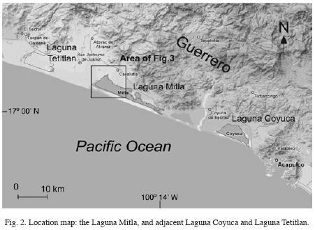
Coastal wetlands are likely to preserve a record of tectonically–induced sea–level changes because of the sensitivity of pollen, diatom and sediment records to uplift or subsidence. We used Landsat TM satellite images and aerial photographs (1:75,000 and 1:25,000 scales) to identify relatively undisturbed wetland sites for field investigations (Fig. 2). The geomorphic environments were mapped and a site was selected for sediment coring at a marsh adjacent to Laguna Mitla on the landward side of the lagoon away from storm activity. The site is about 4 km from the sand bar and the ocean, and away from stream deposition, flooding and erosion. In the marsh area a location showing least anthropogenic disturbance was selected for coring.
Stratigraphy
A core about 6 m long was recovered using a vibrocorer. This core (ACA–03–02, Fig. 3) covers a sediment–stratigraphic record with distinct variations between peat and clay deposition, possibly reflecting changes between terrestrial/brackish and marine deposition. Based on an initial assessment of the core, sediments from this site were felt to show high potential for reconstructing relative sea–level changes in the area (Fig. 2). The 6 meter–long core in a metal tube was split in half, photographed, described, and logged in the field. At field storage facility the core was sampled at 5 cm intervals. Sub–samples were used for radiocarbon dating, geochemical, and visual grain size analysis.
The core location and its approximate relative elevation to mean sea level above the Acapulco tide gauge corrected for geoid variation were determined by differential GPS techniques using double frequency Leica SR520 receivers and AT504 antennas. Nearby GPS stations of the SSN–Sismologia–UNAM" GPS network were used as a reference. All GPS reference stations have approximate orthometric height estimates based on the vertical datum at the Acapulco tide gauge and GPS station ACYA (Acapulco Club de Yates GPS station). This antenna is referenced directly to the bench mark on tide gauge.
Laboratory methods
Sample geochemistry was obtained by Inductively Coupled Plasma Mass Spectrometry (ICP–MS, Perkinelmer 6100DRC Unit). Samples from core depths of 30 cm to 569 cm were analyzed. Sediments from the top 30 cm of the core were highly compacted or were lost during coring, and were not analyzed. Samples were also screened for foraminifera, ostracods and diatoms. Observations of pollen, diatom, phytolith and carbon content for these samples has been described elsewhere (Kennett et al.,2004).
Core chronology was determined using 14C. Radiocarbon dating of wood and charcoal samples at the Accelerator mass–spectrometry (AMS) laboratory at Woods Hole, MA, U.S.A. Plant, wood and charcoal fragments were selected under a binocular microscope. The selected samples were washed with distilled water to remove soil humus and roots. Calibration of radiocarbon dates was performed using the program CALIB 5.0 (Stuiver and Reimer, 1993) and the calibration data set IntCal04 (Reimer et al., 2004).
Results
Geomorphological setting
The coastal landscape along the Guerrero seismic gap is dominated by back–barrier lagoon systems. The lagoons are characterized by extensive bars, marsh areas, mangrove swamps, mudflats and salt pans; with intervening areas dominated by beach ridges, beaches, spits, minor deltas, valleys, extensive alluvial plains and alluvial terraces.
Laguna Mitla is 21 km long and averages 2 km in width. The lagoon is about 1.6 m deep on average and less than 3 m in the deepest part (Guzman–Arroyo et al., 1986). Sediment input is limited. Extensive fringes of mangrove swamps, grassy marshes and salt pans have developed around the lagoon margins. Mangroves line the lagoon on the eastern, western and southern sides, and around islands within the lagoon (Fig. 3). A large salt flat extends inland north of the lagoon. Salt pans also occur inside some of the islands (Fig. 3). Seaward, a sand bar displays sixteen beach ridges. In addition to the active beach ridges, Laguna Mitla has parallel beach ridge remnants within the lagoon. The lagoon is a freshwater–dominated system; it has no open connection to the sea (Paez–Osuna and Osuna–Lopez, 1987). Salinity in the lagoon is very low, ca. 3.5 ppt (Contreras–Espinoza and Warner, 2004).
Stratigraphy
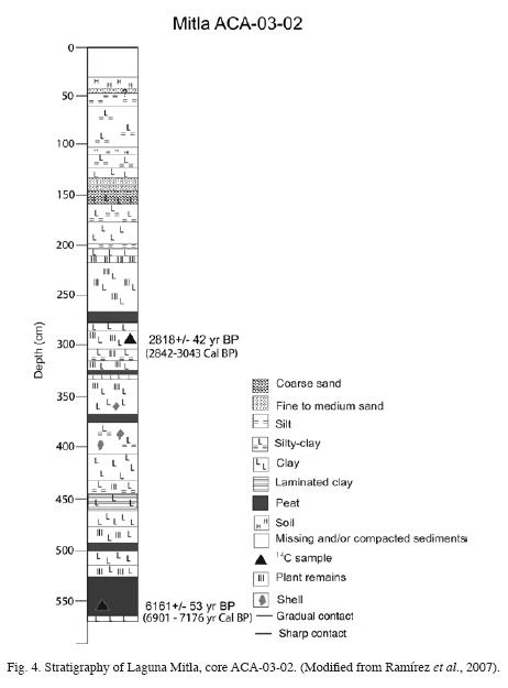
The single sampled core ACA–03–02 (17° 04 24.7" N, 100° 20 51.21" W, at 1.38 meters a.m.s.l, 5.69 m length) showed distinct stratigraphic changes with depth (Fig. 4). The deepest section of the core (c. 456cm – 569 cm core depth) featured interbedded gray clay, black peat, very dark gray to black clay with plant remains, gray clay, black and gray mottled clay, black peat, black clay with abundant plant remains and dark gray clay with plant remains (Fig. 4). A brownish to grayish very finely laminated clay with abundant plant remains is prominent at c. 447 to 456 cm overlain by gray silty clay with large plant/wood fragments at c. 447 cm to 433 cm. A blackish gray clay shows an erosional basal contact at c. 433 cm. The interval between c. 332 cm and 404 cm comprises interbeded very dark gray clay to silty clay with shells and plant remains on top. Interbeded very dark gray clay, black peat, blackish clay with plant remains, dark gray silty clay with abundant charcoal, and dark gray clay occurs between c. 280 cm and 332 cm. From c. 229 cm to 280 cm, highly organic black clay with large woody fragments and well–preserved leaf litter, possibly from mangal vegetation, are present. Peat horizons have apparent erosional contacts at 280 cm and at 260 cm depth, however the 260 cm contact is likely to be a coring artefact, with large fragments of wood at this depth giving the appearance of a contact. Interbedded black clay to very dark gray clay, and very dark gray clay with yellow mottling occurs between c. 200 cm and 229 cm. Gray, yellow streaked silt is interbedded with gray, black and yellow mottled, clay, and gray silty clay between c. 167 cm to 200 cm. Gray clay and gray coarse, poorly sorted sands are interbedded between c. 142 cm and 167 cm, grading to interbedded gray fine sand, and gray silt and clay at c. 136 cm to 142 cm. Gray clay with plant remains and gray fine to medium sand are present between c. 136 cm and 132 cm. Overlaying this, a gray clay with charcoal mottling and silty clay are present between c. 104 cm to 132 cm. Reddish–yellow (iron–oxide rich), dry silty clay, perhaps an incipient soil unit of gray clay, are observed at c. 100 cm to 104 cm. Interbedded gray silty clay and gray silt with isolated iron concretions occurs at c. 45 cm to 104 cm. A sharp and uneven basal contact separates a gray, iron oxide stained medium sand between c. 40 cm and 45 cm. A dark gray silty clay bed with abundant charcoal, plant fragments, and wood (probably a superficial mangrove deposit) comprises the 40 cm to 30 cm interval. Surficial sediments were compacted and/or missing from the top of the core, between c. 0 cm to 30 cm (Fig. 4).
Trace and major element geochemistry
The distribution of over 40 elements was determined from ICP–MS analysis. The concentration vs. depth profile for calcium is highly variable, with concentrations ranging between 5 wt % and zero. Sediments between 223 and 253 cm depth, and 340 cm depth to core base, contain little detectable Ca (Fig. 5). Geochemical profiles for most elements analyzed are similarly variable, and at least partly reflect compositional changes in core stratigraphy including a marked reduction in elements such as Na, S, U, As, V, Sc (Fig. 5); Al and Pb (not shown) occurs between 148 and 223 cm depth, probably reflecting an observed increase in quartz sand content for this depth interval of the core (Fig. 5). Th, La, and Ce (and less distinctly Ti, Cr, Ni, Sc, V and Fe) show prominent concentration maxima at 157 cm depth, which may reflect a pulse of increased heavy mineral input during deposition of sandy sediments. Prominent subsurface concentration maxima occur for As, V, Cu, Ca and Sc (and less distinctly for Ni and Cr) at 287 cm depth. The enrichment in Sc, which is inert to redox reactions, precludes an early–diagenetic source for the observed increases in concentration of these elements. Instead, a distinct concentration maxima at this depth horizon may be a result of pedogenic / laterisation processes, with both Fe and Al also showing slight enrichment here. U and Ca show enriched but slight concentrations at 142 and 151 cm, and 40 cm, coincident with sand beds. Geochemical data via Principal Components Analysis highlight a strong association between As, V, Cu and Sc, but also clearly discriminate Na and S from the other elements (Fig. 6). Na and S (the latter in the form of sulphate or secondary (diagenetic) sulphides generated under brackish to marine conditions) have been used as an indicator of paleosalinity and marine flooding (e.g. López–Buendía et al., 1999; Cundy et al., 2006). Na and S concentration vs. depth profiles show several co–incident subsurface maxima most notably at 561 cm, 370 –380 cm, 330 cm and 260 cm depth. They may reflect increases in paleosalinity and possible marine incursions. Given the dark color of the sediment, a significant proportion of the S measured is likely to be present in the form of secondary diagenetic sulphides, generated via microbially–mediated reduction of seawater sulphate. A general decrease up–core in both Na and S concentrations is also observed, possibly reflecting a generally decreasing marine influence over time.
Radiocarbon ages
Five sub–samples containing organic matter were collected from the core. Two of them were dated via 14C assay: a large wood sample (1.5 cm long) in the black peat from the base of the core and a charcoal fragment at 299–300 cm in the dark gray clay unit (Table 1). The dated fragments came from detritus, thus sample ages may predate deposition by an unknown number of years. We selected fragments that were least likely to be reworked. The fragments were most probably derived from in–situ vegetation. For the purpose of discussion and correlation with other studies in the region, we use yr BP for ages. The top charcoal sample from 299–300 cm depth yielded a radiocarbon age of 2818+42 yr BP (2842–3043 Cal BP). The bottom wood sample from 560–564 cm depth yielded a radiocarbon age of 6161+53 yr BP (6901–7176 Cal BP).
Interpretation
Sedimentary, stratigraphic, and geochemical data from core ACA–03–02 provide evidence of paleoenvironmental and possible paleosalinity changes based on geochemical data. Results from other Guerrero coastal lagoons (Gonzalez–Quintero, 1980; Kennett et al., 2004; Ramirez–Herrera et al., 2007) support the following interpretation of local paleoenvironmental and relative–sea level change.
Paleoenvironments and relative sea–level signature
The 433–569 cm core section shows alternating beds of very dark gray to black finely laminated, organic rich clay and peat. A general downcore increase in Na, U and S concentration, peaking at 561 cm, is indicative of increased salinity at the time of deposition of the extreme basal core units. The absence, or barely detectable presence, of Ca in this core section is most likely indicative of environmental conditions that do not favor the growth and/or post–burial preservation carbonate–shelled organisms such as organic–rich, tropical mangrove swamp/marsh settings (Berkeley et al., submitted). We interpret this environment as a mangrove swamp or shallow marsh formed as a result of the establishment of the beach barrier which isolates Laguna Mitla from high–energy marine deposition. Behind the barrier a brackish lagoon was formed at the time fine sediments were deposited (Fig. 7). Microfossil studies of Laguna Mitla sediments indicate the dominance of Rhizophora (red mangrove) pollen, with Combretacea (white mangrove) and sponge spicules present (Kennett et al., 2004), which support our interpretation of a mangrove swamp or shallow marsh at the time. Our radiocarbon results agree with a proposed date of the establishment of a marginal lagoon setting in the Mitla lagoon by at least 4630+/– 37 yr BP (5297–5647 Cal BP), as reported by Ramirez–Herrera et al. (2007). Following establishment of the beach barrier, the Mitla marsh possibly became progressively more brackish over time (based on a decline in Na, U and S observed in the upper sediments of this core interval).
The radiocarbon dates reported in Table 1 indicate that the cored sediment sequence may be up to c. 6161+53 yr BP (6901–7176 Cal BP) years old, suggesting that the entire cored sequence at Laguna Mitla has been deposited since the mid–Holocene, during and following the period of rapid global decline in the rate of postglacial sea–level rise. Estimates of relative sea–level rise are lacking for the immediate area. However, data from elsewhere along the North American Pacific coast indicate that the rate of regional sea–level rise declined between 6000 and 5200 yr BP (Curray et al., 1969; Atwater et al., 1977; Sirkin, 1985).
The core section between 340 – 433 cm is characterized by very dark gray clay, alternating silty clay and peat with less organic content than the unit below, and the presence of shells. An apparent sharp basal contact divides this unit from the unit below. Also a discernible increase in Na, S, Sr, Ba, Cs, and less distinctly in U and Fe, concentration occurs at about 370–380 cm, suggesting an increase in salinity. The increase in salinity (shown by elemental concentration) suggests a marine flooding event by about 3500 yr BP (by extrapolation). This interpretation is supported by other proxies such as abundant marine diatoms, sponge spicules and the presence of shells in these sediments (Kennett et al., 2004). No conclusively, the apparent sharp basal contact of this unit (less than 3 mm thick) may suggest suddenness of this event. We interpret this flooding event as a sudden relative sea–level change or coastal subsidence (Fig. 7). Similar Na and Sr enriched layers (although of sandier composition), indicative of marine flooding at about 3400 yr BP have been observed at other cores taken in Laguna Mitla (Ramirez–Herrera et al., 2007) and Laguna Coyuca (Ramirez–Herrera et al., 2005). Submerged shell–middens at Laguna Coyuca (Gonzalez–Quintero, 1980; Ramirez–Herrera et al., 2005), and data derived from pollen, diatoms and marine plankton at the adjacent Laguna Tetitlan (Fig. 2) also suggest a marine environment by c. 3170+/–280 yr BP (Gonzalez–Quintero, 1980).
Up–core, about 217 – 340 cm depth, sediments consist of very dark to black clay, with a high organic content, and intercalated peat units. Low concentrations of Ca, and common plant remains (Fig. 4), between 223 and 253 cm, indicate an organic–rich environment or tropical mangrove swamp setting. Prominent subsurface concentration maxima in As, V, Cu, Ca and Sc (and less distinctly Ni and Cr) occur at 287 cm. As noted above, the relative enrichment in Sc (which is not redox sensitive) in this unit indicates that this is not an early diagenetic effect. Instead, it is more likely to be a result of wash–in of material from local terrestrial lateritic soils, which might explain the presence of charcoal in this unit. In general, this sediment core section reflects a deep mangrove swamp probably under constant tidal (marine) flooding at the lower section (Fig. 7). Accordingly, diatoms (mostly marine), sponge spicules, Rhizophora pollen, and Phragmites phytoliths (Phragmites is salt tolerant) are reported as abundant in this section (Kennett et al., 2004). A gradual decrease in paleosalinity up–core (indicated by a significant decrease in Na and S concentration) indicates a decrease in marine/ tidal influence over time at this site.
The 167 to 217 cm core section shows finer sediments with coarse poorly sorted sand (fining upwards) towards the top (at 146 cm). Elemental concentrations (Na, S, As, V, Se, Al, Pb) between 148 and 217 cm, partly reflects the observed increase in quartz sand content over this core section. The geochemical data (specifically the observed decrease in Na and S concentration) broadly support a decrease in salinity. This is in agreement with other palaeosalinity proxies reported from the core: a decrease in salinity has also been suggested by a major reduction in microfossils such as marine diatoms, sponge spicules, and Rhizophora pollen, together with an increase in herbs and the pollen of cultigens (e.g. Asteraceae, Cheno–An, Pocaceae, Polygonaceae, and Zea mays) (Kennett et al., 2004). We interpret this section of the core as corresponding to an environmental change to a marginal mangrove or shallow swamp, a more suitable environment for agriculture suggested by the presence of cultigen pollen proxy (e.g. Zea mays). The observed changes may be explained by a change in frequency and duration of tidal submergence, possibly induced by land elevation changes in this area. A marginal lagoon setting had been proposed for Laguna Mitla by ca. 2300 yr BP from earlier sediment–stratigraphic and microfossil studies of Laguna Mitla (Ramirez–Herrera et al., 2007). A relative drop in sea level, or coastal emergence/tectonic uplift, is suggested by pollen data for the adjacent Laguna Tetitlan, which indicates a decrease in depth of the lagoon to a predominantly shallow–water swamp during the late Holocene ca. 2270+/–105 yr BP (Gonzalez–Quintero, 1980). It is significant that Rhizophora pollen becomes much less abundant after ca. 2270+/–105 yr BP (Gonzalez–Quintero, 1980).
The 30 – 40 cm depth core interval comprises charcoal–rich mangrove sediment. Overall, the elemental composition and sediment data are indicative of a marginal mangrove environment. A reported decrease in Rhizophora pollen and marine diatoms, and the presence of arboreal species, herbs, cultigen, and aquatic species occurs throughout the top 120 cm of the Laguna Mitla sediments (Kennett et al., 2004).
Based on radiocarbon ages of samples from Mitla lagoon, the average net sediment accumulation rate since c. 6161+53 yr BP (6901–7176 Cal BP) was 0.9 to 1.1 mm/yr. It should be noted, however, that this average rate is likely to mask significant variations in sediment accumulation/erosion rates, given the sedimentological variations observed in core ACA–03–02, and the erosional contacts between units (Fig. 4), which indicate the occurrence of erosive episodes, relative sea–level changes or rapid changes in land elevation. This rate, however, is similar to the estimated rate of 0.7–0.9 mm/yr for Laguna Mitla since c. 4630 yr BP (Ramirez–Herrera et al., 2007).
Discussion
Tectonically induced sea–level changes and marine incursions
Are the observed changes a result of climate change? Sea–level changes after ca. 6000–5200 yr BP observed in the sediment–stratigraphic record from Laguna Mitla suggest possible local tectonically–induced changes caused by vertical displacements in coastal elevation, rather than regional (eustatic) sea–level change or climatic changes. The climate record for the Holocene in Mexico is relatively limited (Metcalfe et al., 2000), but data from central and northern Mexico indicate that desert conditions were already established by 4000 yr BP in northern Mexico, while the central highlands record a dry episode that was past by 4000 yr BP and a number of dry intervals in the last 3000 yr BP. A local study in a coastal lagoon in Sonora, Mexico, suggests a wetter climate by 6600 yr BP, though no climate data are provided for the mid– to early–Holocene (Caballero et al., 2005). Thus the strati graphic and geochemical changes, and also changes in microfossils in other studies suggesting increased salinity around 3500–3400 yr BP, cannot be attributed to climate change, instead, a marine incursion as proposed in this study is more plausible.
Are the changes we observe a result of eustatic sea–level change? A single universal Holocene sea–level curve has not been established yet (Pirazolli, 1991) due to the intrinsic difficulties in correlating Holocene sea–level variations worldwide. The current state of the art in Holocene sea–level studies pictures local and regional variations that make a simple extrapolation to other remote regions, such as to the North Sea (Behre, 2003), is questionable. However, sea level was near its present level by ca. 6000 and 5000 yr BP on the California coast (Atwater et al., 1977), on the Northwest Mexico Pacific coast (Curray et al., 1969; Sirkin, 1985) and by 5000 yr BP in the Gulf of Baja California (Ortlieb, 1986, Caballero et al., 2005). The Laguna Mitla stratigraphic record suggests that a beach barrier which isolated Laguna Mitla from high–energy marine deposition had formed in front of a brackish lagoon by ca. 6000 yr BP. Beach barrier construction was concluded at least by 4630 yr BP (Ramirez–Herrera et al., 2007) and by 4660 yr BP at the Coyuca lagoon, near Laguna Mitla (Ramirez–Herrera et al., 2005). An increase in paleosalinity proxies (elemental concentration, micro– and macrofossils) indicates a sudden marine flooding event by 3500 yr BP. Presuming that ENSOs variability was present throughout the mid–Holocene, and underwent a steady increase from the mid–Holocene to the present (Clement et al., 2000): In the mid–Holocene, extreme warm El Niño events were though smaller in amplitude and occurred less frequently. In 1997, during El Niño event, Topex images show a rise of up to 30 cm on the Mexican Pacific coast and input of large volumes of surface warm and less saline water was observed (Filonov et al., 2003); even then, the coast of Guerrero was not inundated far inland and Mitla lagoon sand barrier was not broken, nor overtopping of the lagoon barrier occurred, to our knowledge, nor during the extreme Paulina hurricane storm surges in 1997 (considered the most important hurricane of the century occurring in the North Pacific eastern zone). We believe therefore, that neither relative sea–level rise caused by ENSO, nor storm hurricane surges are likely candidates for the changes observed at Laguna Mitla. Assuming that the sea level was locally stable and the barrier was already established (Curray et al., 1969; Sirkin, 1985, Ortlieb, 1986, Caballero et al., 2005, Ramirez–Herrera et al., 2007), the cause of this change in paleosalinity may have been triggered by a marine incursion (Fig. 7). Recent studies of the sedimentary record of this lagoon indicate a rapid shift from freshwater/brackish to marine conditions at ca. 3400 yr BP (Ramirez–Herrera et al., 2007). Discrete sand layers above the brackish mangrove peat are associated with rapid marine inundation either from a tsunami or a storm–flooding event. The characteristics of the sand deposits (e.g. fining–up sands, internal mud laminations, a sharp–erosional lower contact, and incorporated rip–up mud clasts), an increase in salinity, all agree with described tsunami deposits elsewhere. The distance of the site to the sand barrier (5 km) suggests a catastrophic, seismically–induced, marine flooding (Ramirez–Herrera, et al., 2007).
Did a local earthquake trigger a tsunami which left a sedimentary record in Laguna Mitla? Further indirect evidence for subsidence along this coast is found in the local archeological record, in the form of submerged shell–middens at Laguna Coyuca (Kennett et al., 2004) and marine microfossil proxies (pollen, diatoms and marine plankton) at adjacent Laguna Tetitlan (Gonzalez–Quintero, 1980). Historical data (Farreras, 1997) indicate that tsunami events frequently accompany earthquakes along the Guerrero coastline as noted above and that the 1925 event produced a wave of 7 to 11 m near Zihuatanejo, Guerrero. There is no information on whether any of these tsunamis left a discernable sedimentary signature. The data following support a potential sudden marine flooding event: 1) a sharp contact basal contact between sedimentary units; 2) an abrupt rise in lagoon salinity as recorded by the geochemical data (and microfossil evidence from other studies), which is consistent with, though not exclusive of, sudden incursion of marine waters; 3) re–establishment of reduced salinity conditions in sediments upcore, which supports the interpretation that higher salinities are not the norm for Laguna Mitla.
However the tsunamigenic origin of this event (ca. 3400–3500 yr BP) needs further testing. The tectonic nature of this event, nevertheless, is evident in the stratigraphy of Laguna Mitla which indicates a rapid change from a marginal lagoon to a marine environment by ca. 3500–3400 yr BP (Fig. 7). Short–term sea level records available from 1952 reveal an interseismic subsidence of the Guerrero coast in Acapulco of the order of 3– 4 mm/yr (Alva Vazquez and Kostoglodov, 2007). This suggests that presumably a large subduction thrust earthquake would produce a predominant coastal uplift as the elastic coseismic rebound should balance the strain accumulated during the interseismic period. However, no data are available, to our knowledge, on the coastal response to large earthquakes in historical time within the NW Guerrero gap. Our data show an inconsistency between the predicted coseismic uplift and a notable subsidence of the coastal area derived from the sediment record of a large earthquake and a subsequent marine incursion by ca. 3500 yr BP. We hypothesize that while the recent large earthquakes in the Central Mexico subduction zone have the rupture area width limited (within only 60 km and located below the coast), some prehistoric earthquakes probably ruptured the entire coupled plate interface almost up to the trench that certainly produced significant coastal subsidence and a large marine incursion. Nevertheless, resolving this inconsistency (between interseismic and coeismic coastal deformation) requires more detailed studies.
A gradual return to a less saline mangrove marsh is indicated by a gradual change in sediment, an increase in the pollen of cultigens (e.g. Zea mays), a decrease in Ryzhopora pollen, decrease in marine diatoms, and decrease in geochemical salinity proxies. Here we propose a marginal lagoon or shallow marsh setting by ca. 2050 yr BP. A plausible explanation for a less saline, drier environment is an upward displacement of the marsh surface by a land level change (via tectonic uplift). However, the sediment record of this core is not conclusive in discriminating if this was a gradual or a sudden change. A marginal lagoon setting has been proposed for Laguna Mitla by ca. 2300 yr BP (Ramirez–Herrera et al., 2007) and a relative drop in sea level or coastal emergence (tectonic uplift) has been suggested for the adjacent Laguna Tetitlan by ca. 2270 yr BP (Gonzalez–Quintero, 1980). A marginal mangrove marsh was established by ca. 1150 yr BP, with a minor increase in marine influence for a short period of time.
Conclusions
Mid and Late Holocene sedimentary deposits in Laguna Mitla show strong evidence for changes in depositional environment and palaeosalinity over time, at least some of which may be related to tectonically–induced sea–level change and/or sudden marine inundation. Evidence for land–level changes and marine inundation include buried mangrove peats, sedimentological changes, changes in pa–leosalinity indicated by sediment geochemistry, and pollen and diatom evidence. Radiocarbon dating of the buried mangrove peat suggests that a significant coastal subsidence and marine inundation event occurred by c. 3400–3500 yr BP. Climate changes and regional (eustatic) sea–level changes are unlikely candidates to explain the cause of this inundation, while storms can not explain changes in the lagoon and marsh fill as far inland as those observed (e.g. sand sheets about 5 km inland, Ramirez–Herrera et al., 2007). Hence, a local earthquake and marine incursion, possibly a tsunami, may be responsible for this event. Further work to test this hypothesis will therefore require new targets such as undisturbed beach–ridge plains, salt flats, lagoons; selected trenches and more cores to demonstrate repetition of the processes over time and across new study areas. In addition, the apparent inconsistency observed between the interseismic and coseismic coastal response in this area should be evaluated in more detail through historical (archive and archaeological) and prehistorical (i.e. sedimentary and geomorphological) studies of earthquakes and the resulting coastal response, and numerical modeling of the seismic cycle in the NW Guerrero gap.
Acknowledgements
Financial support was provided to this project by UNAM–Semilla, CONACYT, Consolidación a Grupos de Investigación. Douglas Kennett is thanked for kindly providing logistic support for fieldwork and radiocarbon dates. Special thanks to Marcos Cisternas, Marcelo Lagos, Steven Lefton and Liam Reidy for their useful and constructive comments on an early version of this manuscript. We thank students Melissa Olsen, Sachiko Sakai and Matt Sedor for their enthusiastic field and lab assistance and Alejandra Larrazabal for help with graphics.
Bibliography
Alva Vazquez, A. and V. Kostoglodov, 2007. Aseismic slow slip events in Mexico from tide gauge records. Geos 27, 1, 119. [ Links ]
Anderson, R. S. and K. M. Menking, 1994. The Quaternary marine terraces of Santa Cruz, California: evidence for coseismic uplift on two faults. Geological Society of America Bulletin 106, 649–664. [ Links ]
Atwater, B. F., 1987. Evidence for great Holocene earthquakes along the Outer coast of Washington State. Science 236, 4804, 942–944. [ Links ]
Atwater, B. F. and A. L. Moore, 1992. A tsunami about 1,000 years ago in Puget Sound Washintong. Science 258, 1614–1617. [ Links ]
Atwater, B. F., C. W. Hedel and E. J. Helley, 1977. Late Quaternary depositional history, Holocene sea–level changes, and vertical crustal movement, Southern San Francisco Bay, California, U.S. Geological Survey Professional Paper 1014. [ Links ]
Atwater, B. F., A. R. Nelson, J. J. Clague, G. A. Carver, D. K. Yamaguchi, P. T. Bobrowsky, J. Bourgeois, M. E. Darienzo, W. C. Grant, E. Hemphill–Haley, H. M. Kelsey, G. C. Jacoby, S. P. Nishenko, S. P. Palmer, C. D. Peterson and M. A. Reinhart, 1995. Summary of coastal geologic evidence for past great earthquakes at the Cascadia subduction zone. Earthquake Spectra 11, 1–18. [ Links ]
Atwater, B. F., R. Furukawa, E. Hemphill–Haley, Y. Ikeda and K. Kashima, 2004. Seventeenth–century uplift in Eastern Hokkaido, Japan. Holocene 14, 487–501. [ Links ]
Behre, K.–E., 2003. Eine neue Meeresspiegelkurve für die südliche Nordsee Transgressionen und Regressionen in den letzten 10.000 Jahren. Bd. 28, 9–63. [ Links ]
Berkeley, A., C. T. Perry, S. G. Smithers, B. P. Horton and A. B. Cundy, (submitted). Foraminiferal biofacies across mangrove–mudflat environments at Cocoa Creek, north Queensland, Australia. Marine Geology. [ Links ]
Bodin, P. and T. Klinger, 1986. Coastal uplift and mortality of intertidal organisms caused by the September 1985 Mexico earthquakes. Science 233, 1071–1073. [ Links ]
Borrero, J., M. Ortiz, V. V. Titov and C. E. Synolakis, 1997. Field survey of Mexican tsunami. EOS Transactions American Geophysical Union 78, 8, 85: 87–88. [ Links ]
Caballero, M., M. C. Penalba, M. Martinez, B. Ortega–Guerrero and L. Vazquez, 2005. A Holocene record from a former coastal lagoon in Bahia Quino, Gulf of California, Mexico. The Holocene 15, 1236–1244. [ Links ]
Chagué–Goff, C., S. L. Nichol, A. V. Jenkinson and H. Heijnis, 2000. Signatures of natural catastrophic events and anthropogenic impact in an estuarine environment, New Zealand. Marine Geology 167, 285–301. [ Links ]
Chagué–Goff, C., S. Dawson, J. R. Goff, J. Zachariasen, K. R. Berryman, D. L. Garnett, H. M. Waldron and D. C. Mildenhall, 2002. A tsunami (c. 6300 years BP) and other environmental changes, northern Hawkes Bay, New Zealand. Sedimentary Geology 150, 89–102. [ Links ]
Cisternas, M., B. F. Atwater, F. Torrejón, Y. Sawai, G. Machuca, M. Lagos, A. Eipert, C. Youlton, I. Salgado, T. Kamataki, M. Shishikura, C. P. Rajendran, J. K. Malik, Y. Rizal and M. Husni, 2005: Predecessors of the giant 1960 Chile earthquake. Nature 437, 404–407. [ Links ]
Clement, A. C., R. Seager and M. A. Cane, 2000. Suppression of El Niño during the mid–Holocene by changes in the Earths orbit. Paleoceanography 15, 6, 731–737. [ Links ]
Contreras–Espinosa, F. and B. G. Warner, 2004. Ecosystem characteristics and management considerations for coastal wetlands in Mexico. Hydrobiologia 511, 233–245. [ Links ]
Cundy, A. B., S. Kortekaas, T. Dewez, I. S. Stewart, P. E. F. Collins, I. W. Croudace, H. Maroukian, D. Papanastassiou, P. Gaki–Papanastassiou, K. Pavlopoulos and A. Dawson, 2000. Coastal wetlands as recorders of earthquake subsidence in the Aegean: a case study of the 1894 Gulf of Atalanti earthquakes, central Greece. Marine Geology 170, 3–26. [ Links ]
Cundy, A. B., D. Sprague, L. Hopkinson, H. Maroukian, K. Gaki–Papanasstassiou, D. Papanasstassiou and M. R. Frogley, 2006. Geochemical and stratigraphic indicators of Late Holocene coastal development in the Gythio area, southern Peloponnese, Greece. Marine Geology 230, 161–177. [ Links ]
Curray, J. R., F. J. Emmel and P. J. S. Crampton, 1969. Holocene history of a strand plain lagoonal coast, Nayarit, Mexico. In: Lagunas costeras, Un simposio. Memorias Simposio Internacional, Lagunas costeras, UNAM–UNESCO, Nov. 28–30, 1967, Mexico D.F., pp.63–100. [ Links ]
Dominey–Howes, D. T. M., G. S. Humphreys and P. P. Hesse, 2006. Tsunami and palaeotsunami depositional signatures and their potential value in understanding the late–Holocene tsunami record. The Holocene 16, 1095–1107. [ Links ]
Farreras, S., 1997. Tsunamis en México. En: M. F. Lavin, Contribuciones a la Oceanografía Física en México. Monografía No.3, Unión Geofísica Mexicana, México D. F., pp.73–96. [ Links ]
Filonov, A. E., I. E. Tereshchenko and C. O. Monzon, 2003. Hydrographic monitoring of El Niño 97–98 off the coast of southwest Mexico. Geofísica Internacional 42, 3, 307–312. [ Links ]
González–Quintero, L., 1980. Paleoecología de un sector costero de Guerrero, México (3000 años). Coloquio sobre paleo–botánica y palinología. Memorias, Colección Científica Prehistoria 86, pp. 133–157. [ Links ]
Guzmán–Arroyo, M., O. S. Mañon and P. M. A. Ortíz, 1986. Afinidad limnológica del sistema lagunar costero del estado de Guerrero, México. Boletín del Instituto de Geografía 16, 61–76. [ Links ]
Iglesias A., S. K. Singh, J. F. Pacheco, L. Alcantara, M. Ortiz and M. Ordaz, 2003. Near–Trench Mexican Earthquakes Have Anomalously Low Peak Acceleration. Bulletin of the Seismological Society of America 93, 2: 953–959. [ Links ]
Kennett, D. J., B. Voorhies, J. Iriarte, J. G. Jones, D. Piperno, M. T. Ramirez–Herrera and T. A. Wake, 2004. Avances en el proyecto Arcaico–Formativo: Costa de Guerrero. Instituto Nacional de Antropología e Historia, México, 42p. [ Links ]
Kostoglodov, V. and L. Ponce, 1994. Relationship between subduction and seismicity in the Mexican part of the Middle America trench, Journal of Geophysical Research 99, 729–742. [ Links ]
Kostoglodov, V., R. W. Valenzuela, A. Gorbatov, J. Mimiaga, S. I. Franco, J. A. Alvarado and R. Pelaez, R., 2001. Deformation in the Guerrero seismic gap, Mexico, from leveling observations. Journal of Geodesy 75, 1, 19–32. [ Links ]
Kortekaas, S. and A. G. Dawson, 2007. Distinguishing tsunami and storm deposits: An example from Martinhal, SW Portugal. Sedimentary Geology 200, 2008–221. [ Links ]
Larson, K. M., V. Kostoglodov, A. Lowry, W. Hutton, O. Sanchez, K. Hudnut and G. Suarez, 2004. Crustal deformation measurements in Guerrero, Mexico. Journal of Geophysical Research 109, B04409, doi: 10.1029/2003JB002843. [ Links ]
Long, A. J. and I. Shennan, 1994. Sea–Level Changes in Washington and Oregon and the Earthquake Deformation Cycle. Journal of Coastal Research 10, 825–838. [ Links ]
Lowry, A. R., K. M. Larson, V. Kostoglodov and R. Bilham, 2001. Transient slip on the subduction interface in Guerrero, southern Mexico. Geophysical Research Letters 28, 3753–3756. [ Links ]
Metcalfe, S. E., S. L. OHara, M. Caballero and S. J. Davies, 2000. Records of Late Pleistocene – Holocene climatic change in Mexico – a review. Quaternary Science Reviews, 19, 699 – 721. [ Links ]
Minoura, K., V. G. Gusiakov, A. Kuratov, S. Takeuti, J. I. Svendsen, S. Bondevik and T. Oda, 1996. Tsunami sedimentation associated with the 1923 Kamchatka earthquake. Sedimentary Geology, 106, 145–154. [ Links ]
Nanayama F, K. Satake, R. Furukawa, K. Shimokawa, and B. F. Atwater, 2003. Unusually large earthquakes inferred from tsunami deposits along the Kuril trench. Nature 424,660–63. [ Links ]
Natawidjaja, D. H., K. Sieh, M. Chlieh, J. Galetzka, B. W. Suwargadi, H. Cheng, R. L. Edwards, J.–P. Avouac and S. N. Ward, 2006. Source parameters of the great Sumatran megathrust earthquake of 1797 and 1833 inferred from coral microatolls. Journal of Geophysical Research 111, B06403, doi:10.1029/2005JB004025. [ Links ]
Nelson, A. R., I. ShennanandA. J. Long, 1996. Identifying coseismic subsidence in tidal–wetland: Stratigraphical sequences at the Cascadia subduction zone of western North America. Journal of Geophysical Research 101, B3, 6115–6135. [ Links ]
Nuñez–Cornu, F. J., M. Ortiz and J. J. Sanchez, 2008. The great 1787 Mexican tsunami. Natural Hazards, DOI 10.1007/s11069–008–9239–1, Earth and Environmental Science, Springer, ISSN 0921–030X (Print) 1573–0840 (Online). http://www.springerlink.com/content/52132479530n5425/ [ Links ]
Ortiz, M., S. K. Singh, J. Pacheco and V. Kostoglodov, 1998. Rupture length of October 9, 1995 Colima–Jalisco earthquake (Mw 8) estimated from tsunami data. Geophysical Research Letters, 25, 15: 2857–2860. [ Links ]
Ortiz, M., S. K. Singh, V. Kostoglodov, J. Pacheco, 2000. Source areas of the Acapulco–San Marcos, Mexico earthquakes of 1962 (M 7.1; 7.0) and 1957 (M 7.7), as constrained by tsunami and uplift records. Geofísica Internacional 39, 337–348. [ Links ]
Ortlieb, L., 1986. Nectonique et variations du niveau marin au Quaternaire dans la region du Golfe de Californie, Mexique. Doctorat d'Etat Thesis, Universite d'Aix–Marseille II, France, 2 vols. [ Links ]
Páez–Osuna, F. and J. I. Osuna–López, 1987. Acumulación de metales pesados en Mitla, una laguna costera tropical. Ciencias Marinas 13, 3, 97–112. [ Links ]
Pirazolli, P. A., 1991. World atlas of Holocene sea level changes. Elsevier. Amsterdam. 300 pp. [ Links ]
Ramírez–Herrera, M. T., J. J. Zamorano Orozco, P. M. Ortiz, J. Urrutia–Fucugauchi, R. Reyna, R. Gutierrez, E. León and J. S. Marshall, 1998. Quaternary tectonic uplift along the Pacific coast of Jalisco, Southwest Mexico. EOS Transactions AGU 11(10), Abstract T31E–01. [ Links ]
Ramírez–Herrera, M. T. and J. Urrutia–Fucugauchi, 1999a. Morphotectonic zones along the coast of the Pacific continental margin, southern Mexico. Geomorphology 28, 237–250. [ Links ]
Ramírez–Herrera, M. T., V. Kostoglodov, M. A. Summerfield, J. Urrutia–Fucugauchi and J. J. Zamorano, 1999b. A reconnaissance study of the morphotectonics of the Mexican subduction zone. Annals of Geomorphology 118, 207–226. [ Links ]
Ramírez–Herrera, M. T. and J. J. Zamorano Orozco, 2002. Coastal uplift and mortality of coralline algae caused by a 6.3 Mw earthquake, Oaxaca, Mexico. Journal of Coastal Research 18, 1, 75–81. [ Links ]
Ramírez–Herrera, M. T., V. Kostoglodov and J. Urrutia–Fucugauchi, 2004. Holocene–emerged notches and tectonic uplift along the Jalisco coast, Southwest Mexico. Geomorphology 58, 291–304. [ Links ]
Ramírez–Herrera, M. T., A. Cundy and V. Kostoglodov, 2005. Probables sismos y tsunamis prehistóricos durante los últimos 5000 años en la costa de la brecha sísmica de Guerrero México, Mexico: XV Congreso Nacional de Ingeniería Sísmica, I–07. Sociedad Mexicana de Ingeniería Sísmica México D.F., 1–17. [ Links ]
Ramírez–Herrera, M. T., A. Cundy, V. Kostoglodov, A. Carranza–Edwards, E. Morales, S. Metcalfe, 2007. Sedimentary record of late–Holocene relative sea–level change and tectonic deformation from the Guerrero Seismic Gap, Mexican Pacific coast. The Holocene 17, 8, 1211–1220. [ Links ]
Reimer, P. J., M. G. L. Baillie, E. Bard, A. Bayliss, J. W. Beck, C. J. H. Bertrand, P. G. Blackwell, C. E. Buck, G. S. Burr, K. B. Cutler, P. E. Damon, R. L. Edwards, R. G. Fairbanks, M. Friedrich, T. P. Guilderson, A. G. Hogg, K. A. Hughen, B. Kromer, F. G. McCormac, S. W. Manning, C. B. Ramsey, R. W. Reimer, S. Remmele, J. R. Southon, M. Stuiver, S. Talamo, F. W. Taylor, J. Van der Plicht and C. E. Weyhenmeyer, 2004. IntCal04 Terrestrial radiocarbon age calibration, 26 – 0 ka BP. Radiocarbon 46, 1029–1058. [ Links ]
Sánchez, A. J. and S. F. Farreras, 1993. Catalog of tsunamis on the Western coast of Mexico, World Data Center A for Solid Earth Geophysics, Publication SE–50, National Geophysical Data Center, NOAA, Boulder, Colorado, U.S.A., 79p. [ Links ]
Satake, K. and B. F. Atwater, 2007. Long–term perspectives on giant earthquakes and tsunamis at subduction zones. Annual Review of Earth and Planetary Sciences 35, 349–74. [ Links ]
Sawai, Y., K. Satake, T. Kamataki, H. Nasu and M. Shishikura, 2004. Transient uplift after a seventeenth–century earthquake along the Kuril subduction zone. Science 306, 1918–20. [ Links ]
Sawai Y., Y. Fujii, O. Fujiwara, T. Kamataki, J. Komatsubara, Y. Okamura, K. Satake and M. Shishikura, 2008. Marine incursions of the past 1500 years and evidence of tsunamis at Suijin–numa, a coastal lake facing the Japan Trench. The Holocene 18, 4, 517–528. [ Links ]
Singh, S. K., J. Havskov and L. Astiz, 1981. Seismic gaps and recurrence periods of large large earthquakes along the Mexican subduction zone, Bulletin of the Seismology Society of America 71, 827–843. [ Links ]
Singh, S. K. and G. Suarez, 1986. Review of the Seismicity of Mexico with Emphasis on the September 1985, Michoacan Earthquakes, Instituto de Geofísica, UNAM. [ Links ]
Sirkin, L., 1985. Late Quaternary stratigraphy and environments of the west coastal plain. Palynology 9, 3–25. [ Links ]
Stuiver, M. and P. J. Reimer, 1993. Extended 14C database and revised CALIB radiocarbon calibration program, Radiocarbon 35: 215–230. [ Links ]
Suarez, G., T. Montfret, G. Wittlinger and C. David, 1990. Geometry of subduction and depth of the seismogenic zone in the Guerrero Gap, Mexico. Nature 345, 336–338. [ Links ]
Suarez, G., 2007. How Large can Mexican Subduction Earthquakes be? Evidence of a Very Large Event in 1787 (M8.5). AGU Joint Assembly, Acapulco, Mexico, 22–25 May, 2007. [ Links ]
UNAM Seismology Group, 1986. The September 1985 Michoacan earthquakes: aftershock distribution and history of rupture. Geophysical Research Letters 13, 573–576. [ Links ]
Valdes–Gonzalez, C. and D. A. Novelo–Casanova, 1998. The western Guerrero, Mexico, seismogenic zone from the microseismicity associated to the Petatlan 1979 Petatlan and 1985 Zihuatanejo earthquakes. Tectonophysics 287, 271–277. [ Links ]

